North Beach Redevelopment Initiative Alternative 1 Corpus Christi, Texas
|
|
|
- Jack Armstrong
- 5 years ago
- Views:
Transcription
1
2
3
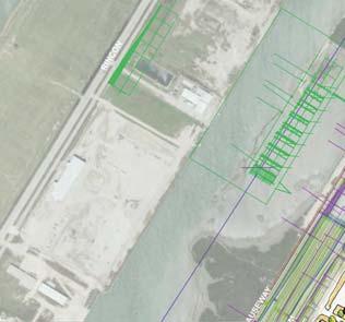
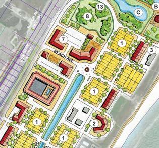
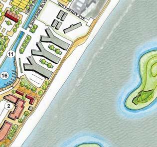
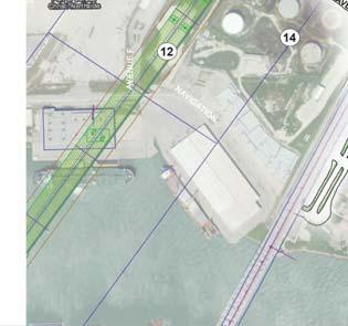
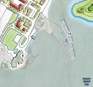
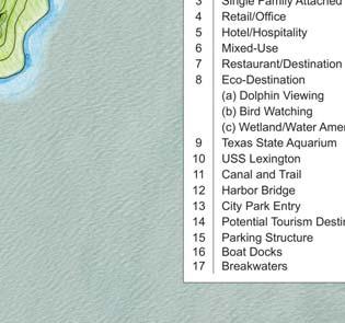
 olphin Viewing (b) Bird Watching (c) Wetland/Water Amenity 9 Texas State Aquarium 0 USS exington Bioswale and Trail Harbor Bridge City Park ntry 4 Potential")
4 A C B 8 BACH TIMON BV SURFSI BV FSPRAY BURSON BRIGPORT BRAKWATR 5 egend Single Family etached Multi-Family Single Family Attached 4 5 Hotel/Hospitality Mixed-Use Restaurant/estination 8 co-estination (a) olphin Viewing (b) Bird Watching (c) Wetland/Water Amenity 9 Texas State Aquarium 0 USS exington Bioswale and Trail Harbor Bridge City Park ntry 4 Potential Tourism estination 5 Parking Structure North Beach Redevelopment Initiative Alternative Corpus Christi, Texas June, 0


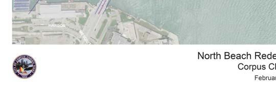

5 North Beach Initiative Corpus Christi, Texas February 8, 08
 Timon Blvd. Overlay (completed) North Beach access improvements Beach Ave.")
 Seagull Blvd. xtension (0) Timon Blvd.")
 Storm Water Management (5) Pedestrian and Bike Trail () Pedestrian Improvements () Close Portion of")
 Close Portion of Gulfbreeze Blvd. () Close Sandbar Ave. () Bring Seagull Blvd.")
 Remove current Seagull Blvd.")
 Canal/ Cove/ Jetties WA N UT Private/ Public Opportunity () Breakwater Islands Private/")


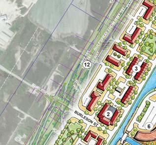
6 North Beach Redevelopment Initiative Capital Improvement Projects (CIP) Propsed CIP ist HU Surfside Blvd. Overlay (completed) Timon Blvd. Overlay (completed) North Beach access improvements Beach Ave. Improvements Traffic Circle and Aquisition Wetlands Identification Gulfspray Ave. Pedestrian and Bike Improvements (9) Seagull Blvd. xtension (0) Timon Blvd. Realignment () Connect Walnut St. and Paul Pl. () Connect lm St. to Surfside Blvd. () Connect Coastal Ave. (4) Storm Water Management (5) Pedestrian and Bike Trail () Pedestrian Improvements () Close Portion of Reef Ave. (8) Close Portion of Seagull Blvd. (9) Close Portion of Timon Blvd. (0) Close Portion of Gulfbreeze Blvd. () Close Sandbar Ave. () Bring Seagull Blvd. to collector standards () Bring streets up to adopted street standards (4) Remove W. Surfside Blvd. (5) Remove current Seagull Blvd. () co-estination () olphin Park (8) Surfside Park (9) Kiwanis Park (0) Potential Cruise Ship Tourism Infrastructure () Canal/ Cove/ Jetties WA N UT Private/ Public Opportunity () Breakwater Islands Private/ Public Opportunity 9 () TxOT street projects OR BU R New Road Construction Projects New Open Space A HO T K B GO F R P P GP P 8 Y SB V B BV AG U BU S WA R SH ICK T I N Bike/Pedestrian Projects 4 A V BR K RS FB R Z BV AC H A TP P N AY 8 A PA U 9 NS B V 0 OR Street Realignment SO T F SS SH Road Closures CH S 5 4 Y w Ne GN AR R 5 PR R V AS U WA YB UR CH TA V SU FS N B HA Y S 5 C CH HW or Ha rb _ 0 February, 08 RIS SA TA V A TO U BO AR A V TR SB RA V Br i dg ea llig nm en t KW AT RF FW Y P A SU WY BR 8 HW IG F BR PU M TI M TA B V CO AS ON M SU R F SI B V ON BV M TIM PU () () () (4) (5) () () (8) SA N 0 BA RA V
 (completed) North Beach access improvements from. Causeway to Surfside Blvd.")

7 North Beach Redevelopment Initiative Proposed Capital Improvement Projects ist Surfside Blvd. Overlay from Coastal Ave. to Reef Ave. (5,400 lf) (completed) Timon Blvd. Overlay from Coastal Ave. to Beach Ave, and from Sandbar Ave. to ast Causeway Blvd. (,50 lf) (completed) North Beach access improvements from. Causeway to Surfside Blvd.: explore curved loop road (,000 lf) or free right turn options (400 lf), requires a detailed engineering, cost-comparison, and design process 4 Beach Ave. roadway/ pedestrian improvements and area beautification from ast Causeway to Beach Parking. ead end at Beach Parking (,50 lf) Construction of Traffic Circle at the intersection of Beach Ave. with Surfside Blvd. and Timon Blvd. including gateway feature with wayfinding (500 lf) and acquisition for roads under current Harbor Bridge from Burleson St. to Breakwater Ave. U.S. Army Corps of ngineers Wetlands Identification for City owned land, right of way, and easements on North Beach Gulfspray Pedestrian and Bicycle infrastructure Improvements from. Causeway Blvd. to Beach Access. (,400 lf) xtend Seagull Blvd. from Plum St. to Burleson St. (,00 lf) Realign Timon Blvd. from Bushick Pl. to Breakwater Ave. (,000 lf) Connect Walnut St. and Paul Pl. from. Causeway Blvd. to New Timon Blvd. alignment (800 lf) Connect lm St. from the New Timon Blvd. alignment (current W. Surfside Blvd.) to Surfside Blvd. (0 lf) Connect Coastal Ave. from Seagull Blvd. to Surfside Blvd. (90 lf) Storm Water Management in median between Surfside Blvd. and Timon Blvd. running north/south from Coastal Ave. to Beach Ave. (8.5 acres) Pedestrian and bicycle trail along Surfside Blvd. and Timon Blvd. median running north/south from Coastal Ave. to Beach Ave. (0,00 lf) Pedestrian improvements from ast Causeway Blvd. at Timon Blvd. under Causeway to West Causeway Blvd. and Beach Ave. (,800 lf) Close Reef Ave. from Seagull Blvd. to Timon Blvd. (00 lf) (in conjunction with new development) Close Seagull Blvd. north of Beach Ave. (50 lf) (in conjunction with new development) Close portion of Timon Blvd. north of Beach Ave. (,000 lf) (in conjunction with co Park development) 0 Close Gulfbreeze Blvd. north of Gulden St. (400 lf) (in conjunction with olphin Park development) 4 5 Close Sandbar Ave. (00 lf) (in conjunction with co Park development) Bring Seagull Blvd. to collector standards from Breakwater Ave. to Gulfspray Blvd. (4,00 lf) Bring streets up to adopted City standards with AA sidewalks and drainage (in conjunction with new development) Remove West Surfside Blvd. from Burleson St. to lm St. (,00 lf) Remove Seagull Blvd. from Burleson St. to lm St. (,500 lf) Public-Private Partnership Opportunity - co-estination to integrate more open space and serve as wetland mitigation opportunity (5 acres) olphin Park Improvements 8 Surfside Park Improvements 9 Kiwanis Park and Community Center Improvements 0 Public-Private Partnership Opportunity - Potential Cruise Ship Tourism Infrastructure Canal, Cove, and Jetties - Private/ Public Opportunity Breakwater Islands - Private/ Public Opportunity TxOT projects associated with Harbor Bridge Relocation: street projects under the current bridge - projects TB *All measurements are approximate February, 08
San Pedro Waterfront Development Efforts Presentation for Trade, Commerce & Technology Committee
 San Pedro Waterfront Development Efforts Presentation for Trade, Commerce & Technology Committee November 17, 2015 Ports O Call Area Redevelopment Ports O Call Area Redevelopment Implementation Schedule
East Link Project Update. Maintenance of Traffic During Construction. April 21, 2015
 East Link Project Update Maintenance of Traffic During Construction April 21, 2015 1 Agenda TFP project 242 Bellevue Way HOV Bellevue Way - Maintenance of Traffic During Construction Early Work Utilities
Public Information Center August 12, 2010
 Route 52 Causeway Bridge Replacement & Somers Point Circle Elimination Project Somers Point Atlantic County Public Information Center August 12, 2010 Ocean City Cape May County Presentation Overview General
Wichita Falls MPO - MTP Project List 1 of 6
 Wichita Falls MPO - MTP Project List 1 of 6 FUNDING SCHEDULE FOR WICHITA FALLS MPO 2015-2040 M TxDOT Ten-Year Plan 2016-2026 TxDOT STATE, PROJECTS (TABLE I) ESTIMATED STATUS HIGHWAY CSJ PROJECT LIMITS
FORT WORTH DISTRICT. Springtown Area Projects. Loyl C. Bussell, P.E. Acting District Engineer. Thursday, February 8, 2018 Date.
 FORT WORTH DISTRICT Springtown Area Projects Loyl C. Bussell, P.E. Acting District Engineer Photo by Liam Frederick Footer Text Thursday, February 8, 2018 Date Maintaining a Safe System TxDOT is responsible
Georgetown-Lewes Rail/Trail Study. Rail/Trail Study: Cool Spring to Cape Henlopen State Park New Road Extension (House Resolution No.
 Georgetown-Lewes Rail/Trail Study Rail/Trail Study: Cool Spring to Cape Henlopen State Park New Road Extension (House Resolution No. 47) August 22, 2011 Presentation Outline Background Benefits Statewide
Northwest Triangle. Redevelopment Proposal. Property Acquisition, Engineering, and Demolition. December, 2005 REDEVELOPMENT AUTHORITY OF THE
 Northwest Triangle Redevelopment Proposal Property Acquisition, Engineering, and Demolition December, 2005 REDEVELOPMENT AUTHORITY OF THE CITY OF YORK York City Redevelopment Authority 14 West Market Street,
Proposed Bicycle Lanes on Yonge Street from Queens Quay to Front Street
 STAFF REPORT ACTION REQUIRED Proposed Bicycle Lanes on Yonge Street from Queens Quay to Front Street Date: March 12, 2007 To: From: Toronto and East York Community Council Director, Transportation Infrastructure
WHY MOVE YOUR BUSINESS TO HOLLYWOOD?
 WHY MOVE YOUR BUSINESS TO HOLLYWOOD? Close to international airport and seaport Centrally located in 3.5 million population No personal income tax Diverse labor force and talent pool Waterfront executive
STORY MILL COMMUNITY PARK
 OWNER: City of Bozeman Department or Parks and Recreation P.O. Box 1230, 415 N. Bozeman Street Bozeman, MT 59715 Tel: (406)-582-2908 APPLICANT: The Trust for Public Land 1007 E. Main Street, Suite 300
Boston Redevelopment Authority 2/26/ Chestnut Hill Avenue Boston/Brookline, MA
 Boston Redevelopment Authority 2/26/2014 Cassidy Playground Waterworks Design revisions made since the DPIR submission March 2013 Massing - Reduced project 16,030 SF, for a total project area of 218,520
ANCLOTE COASTAL TRAIL ALTERNATIVES ANALYSIS STUDY
 ANCLOTE COASTAL TRAIL ALTERNATIVES ANALYSIS STUDY PASCO COUNTY MPO JULY 2015 PROJECT OVERVIEW... INTRODUCTION EXECUTIVE SUMMARY CONTEXT... TAMPA BAY AREA, PINELLAS, & PASCO COUNTY S MULTI-USE TRAIL PLANS
A CASE FOR COMPLETING THE JORDAN RIVER PARKWAY: A
 A CASE FOR COMPLETING THE JORDAN RIVER PARKWAY: A safe crossing at 9000 South and 850 West Proposed 9000 South Underpass Parkway Timeline Parkway, Trail, and Tourism Facts Blueprint Jordan River 1971 1973
DRAFT TH AVE NE URBAN DESIGN MERIT PRESENTATION DPD# NOVEMBER 2017
 DRAFT 11.08.17 4801 24TH AVE NE URBAN DESIGN MERIT PRESENTATION 17-002 DPD#3027312 16 NOVEMBER 2017 PROJECT BACKGROUND URBAN DESIGN ANALYSIS VACATION / NO-VACATION COMPARISON URBAN DESIGN MERIT INTRODUCTION
Project Scope: New City Hall New Police Department New Mixed-Use Parking Structure Community Improvements
 Project Scope: New City Hall New Police Department New Mixed-Use Parking Structure Community Improvements CITY HALL / POLICE DEPARTMENT / MIXED-USE PARKING STRUCTURE A R C H I T E C T S D E S I G N G R
LAGUNA ISLES DEVELOPMENT
 DEVELOPMENT FOR SALE LAGUNA ISLES DEVELOPMENT State Highway 361 South of Downtown Port Aransas, Texas 44.77 ACRES MIXED-USE DEVELOPMENT + 300 planned SF lots, most with bay or golf course frontage and
BON SECOUR VILLAGE 283 ACRE COASTAL MIXED USE DEVELOPMENT OPPORTUNITY GULF SHORES, AL HEATH MILLIGAN. PRINCIPAL
 283 ACRE COASTAL MIXED USE DEVELOPMENT OPPORTUNITY 1642 Powers Ferry Road SE Suite 250 Marietta, GA 30067 www.macallanre.com 283 ACRE COASTAL MIXED USE DEVELOPMENT OPPORTUNITY INTRODUCTION MACALLAN REAL
Add-A-Lane Contract V. along a Section of I-95 includes 6 Bridges
 Newton Needham Chamber of Commerce Add-A-Lane Contract V along a Section of I-95 includes 6 Bridges Project File No. 603711 July 29, 2014 1 Agenda Project Update Overview Bid and Contract Award Schedule
AGENCY NAME TRANSPORTATION
 TRANSPORTATION TRANSPORTATION AGENCY NAME Prince William County FY 2015 BUDGET CIP-TRANSPORTATION 561 Fuller Road/Fuller Heights Road Improvements Total Project Cost - $4.4 M This project will widen Fuller
SANDAG s Regional Transportation Plan
 SANDAG s Regional Transportation Plan Oceanside 5 Camp Pendleton Carlsbad P A C C I I F I C C O O C C E E A A N N 472 398 76 Encinitas 399 78 Solana Beach 472 Vista 15 San Marcos 399 399 470 610 Escondido
US 19 Sunset Point Rd to Countryside Blvd.
 Frontage Lanes Alternative Six-Lane Roadway Two-Lane, One-Way Frontage Lanes Close All Median Openings w/ Concrete Median Barrier Construct Within Existing Right-of-Way Status Update Construction started
Completion: August 2011 LS #321 Design LS #8
 1 CIPNumber c350406 2 c350302 3 c350902 LEGEND PERMITTING/ BIDDING CHARLOTTE COUNTY UTILITIES Burnt Store Water Reclamation Facility (Expansion to 0.75 MGD) East Port Expansion Water Reclamation Facility
Specification Details: Coded Dash Number M28803/1 -MC PART LISTINGS MANUFACTURER'S DESIGNATION OR TYPE NUMBER TEST OR QUALIFICATION REFERENCE
 Specification Details: DLA Land and Maritime - VQ Date: 2/4/2015 Specification: MIL-DTL-28803 Title: Display, Optoelectronic, Readouts, Backlighted Segmented Federal Supply Class (FSC): 5980 Conventional:
Abbott Rd Rehabilitation Phase II - Elmore Rd to Birch Rd
 Abbott Rd Rehabilitation Phase II - Elmore Rd to Birch Rd Project ID SOA07003 Department State of Alaska Project Type Improvement Start Date December 2017 Location Assembly: Section 4, Seats F & G, Assembly:
Airport Planning Area
 PLANNING AREA POLICIES l AIRPORT Airport Planning Area LOCATION AND CONTEXT The Airport Planning Area ( Airport area ) is a key part of Boise s economy and transportation network; it features a multi-purpose
EXTERNAL COMMUNICATIONS TEAM MEETING MARCH 2015
 EXTERNAL COMMUNICATIONS TEAM MEETING MARCH 2015 1 SEGMENT 1 2 THE WISHBONE Connects the TEXpress Managed Toll System to the 35Express Managed Toll System Limits: Crown Road (near Royal Lane) to Valley
RESORT AREA STRATEGIC ACTION PLAN (RASAP) STEERING COMMITTEE MEETING - APRIL 3, 2019
 STEERING COMMITTEE MEETING - APRIL 3, 2019") RESORT AREA STRATEGIC ACTION PLAN (RASAP) STEERING COMMITTEE MEETING - APRIL 3, 2019 Welcome & Introductions - Deb Zywna AGENDA FY 20 Resort CIP Proposed Projects - Kathy Warren ORDFBC Design Guidelines
RESORT AREA STRATEGIC ACTION PLAN (RASAP) STEERING COMMITTEE MEETING - APRIL 3, 2019 Welcome & Introductions - Deb Zywna AGENDA FY 20 Resort CIP Proposed Projects - Kathy Warren ORDFBC Design Guidelines
SAN ANTONIO RIVER IMPROVEMENTS PROJECT. August 6, 2008
 SAN ANTONIO RIVER IMPROVEMENTS PROJECT August 6, 2008 1 History of the SA River Improvements 1921 Flood Olmos Dam Complete in 1929 Downtown Flood Relief Projects in 1950 s Dams on the River Channel and
PUBLIC DRAF MISSION TRAILS REGIONAL PARK Mission Gorge 5-27
 5.4. Mission Gorge MISSION TRAILS REGIONAL PARK The goal for the Mission Gorge area is to provide a variety of sustainable trails and other park amenities that can accommodate the high number of visitors
Dallas Love Field Capital Program. September 16, 2015
 Dallas Love Field Capital Program September 16, 2015 1 The Dallas Airport System Dallas Love Field, Dallas Executive Airport, Downtown Vertiport A $86 million City of Dallas enterprise Operated by the
Trinity River Vision Update
 Trinity River Vision Update Presented to the City Council by: Mark Rauscher, Program Manager Planning & Development Department / Program Management Office August 23, 2011 1 Purpose of the Briefing Overview
SAN RAFAEL City Council January 20, 2015
 SONOMA MARIN AREA RAIL TRANSIT SMART CENTRAL SAN RAFAEL STATUS UPDATE SAN RAFAEL City Council January 20, 2015 CENTRAL SAN RAFAEL SMART SOUTH OF PUERTO SUELLO TUNNEL 1. Active Construction 2. Construction
Northeast Corridor Transportation Update
 Northeast Corridor Transportation Update Presented by: Stuart Basham Division 10 Planning Engineer North Carolina Department of Transportation October 2, 2014 Today s presentation includes: I-485 Outer
Damen Elston Fullerton Reconstruction, Intersection Improvements CDOT Project B-1-501
 Damen Elston Fullerton Reconstruction, Intersection Improvements CDOT Project B-1-501 Bird s Eye View of Existing INTRODUCTION This project is part of the City s Building a New Chicago initiative in conjunction
Lawrence Loop SWOT Analysis
 Alignment: D1 (Map Color: Dark Blue) Description: This alignment connects to the north end of the Burroughs Creek Trail and continues along the west side of the Railroad to 8 th Street. Strengths: - This
Blue River Trail Master Plan JSA to Town Hall June 2004
 Blue River Trail Master Plan JSA to Town Hall June 2004 Prepared for: Silverthorne Town Council Silverthorne SPORT Committee Department of Recreation and Culture Silverthorne Public Works Silverthorne
Basic Project Information
 FY 2015-16 PROJECT DESCRIPTION FORM (2C) Submitting Agency: Loudoun County Basic Project Information Project Title: Loudoun County Parkway (VA Route 607) U.S. 50 to Creighton Rd. (2C) Project Type (check
Clackamas County Development Agency
 Clackamas County Development Agency Development Services Building, 150 Beavercreek Rd., Oregon City, OR 97045 www.clackamas.us/transportation/renewal 503-742-4323 The Clackamas County Board of Commissioners
❷ s é ②s é í t é Pr ③ t tr t á t r ít. á s á rá. Pr ③ t t í t. t í r r t á r t á s ý. r t r é s②sté ②
 ❷ s é ②s é í t é Pr ③ t tr t á t r ít á s á rá Pr ③ t t í t t í rá r í ➎ár t í r r t á r t á s ý r t r é s②sté ② t P á í á ② r í ➎ár ③ í é á s é rá í s é r t é r ② s ý ③ t í é ② rá t ③ t tét rá ③ é r
Welcome to Dayton Parkway Interchange Open House. November 26, 2018
 Welcome to Dayton Parkway Interchange Open House November 26, 2018 Project Partners Minnesota DOT Hennepin County City of Rogers Dayton Project History NW Hennepin County I94 Study 2007/08 Interchange
Birmingham City Centre Vision for Movement
 Birmingham City Centre Vision for Movement Wes Sedman - Centro Commissioning Team Laying the foundations for a vibrant and liveable global city Birmingham Big City Plan - A City Centre Masterplan A vision
FLORIDA S HOLLYWOOD BEACH AND DOWNTOWN BUSINESS AND REDEVELOPMENT OPPORTUNITIES CAPITAL IMPROVEMENT PLAN
 FLORIDA S HOLLYWOOD BEACH AND DOWNTOWN BUSINESS AND REDEVELOPMENT OPPORTUNITIES CAPITAL IMPROVEMENT PLAN 2015-2019 WHY MOVE YOUR BUSINESS TO HOLLYWOOD? Close to international airport and seaport Centrally
Existing Housing Stock. Four Square Revisited Toward Zero Energy Renovation. Getting Bigger as Time Goes On. How Old and New Houses Use Energy
 Fur Squar Rvt Twar Zr Ery Rvat Bty Pttt, FAIA Bu S wwwbu Nubr f Hu Ut (thua) 25000 20000 15000 10000 5000 0 bfr 1919 Ext Hu Stk A f US Hu Stk (a ut typ) I N f Ery Rtrft Nw H 1920 1930 1940 1950 1960 1970
APPENDIX A: Planning Consistency Checklist
 APPENDIXA: PlanningConsistencyChecklist Planning Requirements for Environmental Document Approvals with Segmented Implementation Document Information: Date: 1/20/2015 Document Type: EA Document Status:
Route:140-AM-2 ST ISABELLA Driver:FIRST STUDENT, ( )
") 8/9/2018 1:41:30 PM Route:140-AM-2 ST ISABELLA Driver:FIRST STUDENT, (403-531-3900) End Time:8:45 am EFFECTIVE DATE: September 4, 2018 Route Updated: August 15, 2018 8:33 am (1) INVERNESS PA SE@MCKENZIE
8/9/2018 1:41:30 PM Route:140-AM-2 ST ISABELLA Driver:FIRST STUDENT, (403-531-3900) End Time:8:45 am EFFECTIVE DATE: September 4, 2018 Route Updated: August 15, 2018 8:33 am (1) INVERNESS PA SE@MCKENZIE
Report sales to a QEZE of nonresidential gas (including propane in containers of 100 pounds or more), electric, refrigeration, and steam services.
, electric, refrigeration, and steam services.") New Yk State Department of Taxation and Finance Consumer s Utility and Fuel Taxes f Nonresidential Gas, Electric, Refrigeration, and Steam Services Sold to a Qualified Empire Zone Enterprise (QEZE) File
New Yk State Department of Taxation and Finance Consumer s Utility and Fuel Taxes f Nonresidential Gas, Electric, Refrigeration, and Steam Services Sold to a Qualified Empire Zone Enterprise (QEZE) File
FINAL. Bicycle/Pedestrian Feasibility Study City of DeBary Dirksen Drive Trail. Prepared For: Volusia County MPO
 City of DeBary Dirksen Drive Trail FINAL Prepared By: Reynolds, Smith and Hills, Inc. Prepared For: Volusia County MPO September 2007 Table of Contents INTRODUCTION...1 PROJECT PURPOSE AND SCOPE...2 PHYSICAL
Chapter 4.0 Alternatives Analysis
 Chapter 4.0 Alternatives Analysis Chapter 1 accumulated the baseline of existing airport data, Chapter 2 presented the outlook for the future in terms of operational activity, Chapter 3 defined the facilities
Honolulu International Airport (HNL) Transit Rail Alignment Options Review
 Transit Rail Alignment Options Review") Honolulu International Airport (HNL) Transit Rail Alignment Options Review Presented to: Federal Transit, Region IX By: Debbie Roth, Acting Manager, Western-Pacific Region, Airports Division Steve Wong,
Honolulu International Airport (HNL) Transit Rail Alignment Options Review Presented to: Federal Transit, Region IX By: Debbie Roth, Acting Manager, Western-Pacific Region, Airports Division Steve Wong,
North Denver Cornerstone Collaborative. Six Projects One Vision
 North Denver Cornerstone Collaborative Six Projects One Vision Creating the NDCC: An Initiative of Mayor Michael B. Hancock Founded by Mayor Hancock in January 203. Appointed Kelly Leid as Executive Director
Transportation Supporting Dulles Airport
 Transportation Supporting Dulles Airport Committee for Dulles Economic Development and Transportation Committee July 12, 2018 Tom Biesiadny, Director Fairfax County Multiple Transportation Improvements
Main Street Station Upgrades
 Main Street Station Upgrades Public Meeting Hope United Church 1 Main Street Station Upgrades Bus diversions Planned improvements Construction staging Pedestrian flows 2 Main Street Station Aerial Bar
The Vision for the San Juan Islands Scenic Byway
 The Vision for the San Juan Islands Scenic Byway 2 Judd Cove, Orcas Island, Courtesy of Kurt Thorson (kurtthorson.com) and San Juan County Land Bank Vision for the San Juan Islands Scenic Byway The San
STAGE 2 & 3 Pavement reconstruction within viaduct footprint, pavement widening and resurfacing N/S of viaduct footprint, sidewalk
 STAGE 1 Viaduct removal, deck replacement on the River Bridge, and approach of the Chicago River Bridge north to Roscoe) Maintain local access roadways - 1 lane in each direction A signed alternate route
City of Walnut STUDY AREA PROFILE
 City of Walnut STUDY AREA PROFILE STUDY AREA ID #133 BASE MAP PARK METRICS WHERE ARE PARKS MOST NEEDED AMENITY QUANTITIES AND CONDITIONS PARK NEEDS FRAMEWORK PROJECT COST ESTIMATES PROJECT REPORTING FORM
Business Item No XXX. Proposed Action That the Metropolitan Council approve the Coon Creek Regional Trail Master Plan.
 Business Item No. 2015-XXX Metropolitan Parks and Open Space Commission Meeting date: July 7, 2015 For the Community Development Committee meeting of July 20, 2015 For the Metropolitan Council meeting
Staff Report Sign Design
 Staff Report Sign Design July 29, 2014 Planning & Zoning Commission Meeting Report date July 23, 2014 Project type Sign Design Legal description Section 2, Township 5, Range 82 Lots 3&4, S1/2NW1/4, SW1/4
Committee Report. Community Development Committee For the Metropolitan Council meeting of April 13, Business Item No.
 Committee Report Business Item No. 2016-48 Community Development Committee For the Metropolitan Council meeting of April 13, 2016 Subject: Harriet Island-South St. Paul Regional Trail Master Plan, Saint
Port Everglades Master/Vision Plan Update
 Port Everglades Master/Vision Plan Update Environmental Stakeholder Meeting June 15, 2009 Discussion to Focus On: Updating the 2006 Port Everglades Master Plan Issues dealing with the Turning Notch Potential
Members: Guest(s): USRN DECISION CHANGE
: USRN DECISION CHANGE") AASHTO Special Committee on U.S. Route Numbering () Report to the Standing Committee on Highways (SCOH) Decisions & Meeting Minutes October 29, 2010 - Biloxi, Mississippi Members: Guest(s): Chair Don Vaughn,
AASHTO Special Committee on U.S. Route Numbering () Report to the Standing Committee on Highways (SCOH) Decisions & Meeting Minutes October 29, 2010 - Biloxi, Mississippi Members: Guest(s): Chair Don Vaughn,
Lake Erie Commerce Center Traffic Analysis
 LOCATION: East of NYS Route 5 at Bayview Road Town of Hamburg Erie County, New York PREPARED BY: Wendel Companies 140 John James Audubon Parkway Suite 200 Amherst, New York 14228 January 2012 i ii Table
AGENDA ITEM 5 D WAKULLA ENVIRONMENTAL INSTITUTE (WEI) TRAIL FEASIBILITY STUDY
 TRAIL FEASIBILITY STUDY") March 19, 2018 AGENDA ITEM 5 D WAKULLA ENVIRONMENTAL INSTITUTE (WEI) TRAIL FEASIBILITY STUDY TYPE OF ITEM: Action STATEMENT OF ISSUE The Wakulla Environmental Institute (WEI) Trail is one of several trails
March 19, 2018 AGENDA ITEM 5 D WAKULLA ENVIRONMENTAL INSTITUTE (WEI) TRAIL FEASIBILITY STUDY TYPE OF ITEM: Action STATEMENT OF ISSUE The Wakulla Environmental Institute (WEI) Trail is one of several trails
Public Open House. Chief Peguis Trail Project
 Public Open House Chief Peguis Trail Project CHIEF PEGUIS TRAIL OPEN HOUSE Welcome! Please browse the display boards Project Engineers and City of Winnipeg representatives are available to address your
Wilds. Headwaters. Lakes. Oxbows. Falls
 56 5 4 3 Wilds Headwaters Lakes Oxbows Falls 57 Zones It could be said the on-the-ground essence of this master plan appears within the next 6 pages of this report. As we learned in the preceding Cultural
EXTERNAL COMMUNICATIONS COMMITTEE MEETING APRIL 2015
 EXTERNAL COMMUNICATIONS COMMITTEE MEETING APRIL 2015 35EXPRESS PROJECT OVERVIEW 2 SEGMENT 1 3 SOUTH OF I-635 May Shift northbound mainlane traffic east in the southeast quadrant Miscellaneous frontage
Committee Report. Community Development Committee For the Metropolitan Council meeting of August 12, Business Item No.
 Committee Report Business Item No. 2015-168 Community Development Committee For the Metropolitan Council meeting of August 12, 2015 Subject: Coon Creek Regional Trail Master Plan, Anoka County Proposed
City of Grand Island Tuesday, December 12, 2017 Council Session
 City of Grand Island Tuesday, December 12, 2017 Council Session Item E-3 Public Hearing on One & Six Year Street Improvement Plan Council action will take place under Resolution item I-1. Staff Contact:
SAME/SBA CONFERENCE. Col. Christopher W. Sallese Commander, Galveston District U.S. Army Corps of Engineers April 11, 2012
 SAME/A CONFERENCE Col. Christopher W. Sallese Commander, Galveston District U.S. Army Corps of Engineers April 11, 2012 U.S. Army Corps of Engineers Galveston District BUILDING STRONG 1 History of the
Fuller/Fuller Heights Road Improvements
 Fuller/Fuller Heights Road Improvements Total Project Cost - $4.4M Project Description This project will construct a mini-roundabout at the intersection of Fuller Heights Road and Old Triangle Road to
Exterior Wayfinding Signage Design Standards
 Exterior Wayfinding Signage Design Standards 05/25/12 TABLE OF CONTENTS CONTENTS SIGNAGE POLICY 2 VEHICULAR SIGNS 3 Main Gateway [Sign 1]... 3 Parking Lot [Sign 2]... 4 Building Identification [Sign 3]...
13 MILLION Annual Visitors. 780,000 Square Feet. THE MOST VISITED TOURIST ATTRACTION in South Carolina
 THE MOST VISITED TOURIST ATTRACTION in South Carolina ABOUT BROADWA AT THE BEACH Broadway at the Beach is South Carolina s number one tourist destination, attracting more than 13 million visitors annually.
Dungeness Recreation Area County Park Master Plan
 Dungeness Recreation Area County Park Public Outreach Meeting October 10, 2007 Project Overview USFWS Site Dungeness Recreation Area County Park Meeting Objectives: Re-Introduce project; provide status
P.O. Box 1749 Halifax, Nova Scotia B3J 3A5 Canada Item No Halifax Regional Council January 26, 2016
 P.O. Box 1749 Halifax, Nova Scotia B3J 3A5 Canada Item No. 14.1.2 Halifax Regional Council January 26, 2016 TO: Mayor Savage and Members of Halifax Regional Council SUBMITTED BY: John Traves, Q.C. Acting
City of Palmdale - Westside STUDY AREA PROFILE
 City of Palmdale - Westside STUDY AREA PROFILE STUDY AREA ID #125 BASE MAP PARK METRICS WHERE ARE PARKS MOST NEEDED AMENITY QUANTITIES AND CONDITIONS PARK NEEDS FRAMEWORK PROJECT COST ESTIMATES PROJECT
Changes in TIP projects Draft vs. Final Draft
 Attachment 2 Dollars in $1,000 Key 08698 Franklin Road and Cloverdale Road Intersection Changes in TIP projects Draft vs. Final Draft RW - $1,314 UT - $1,000 CE - $341 CN - $3,675 CN - $499 09438 Caldwell
COASTAL CONSERVANCY. Staff Recommendation November 6, 2008 SAN FRANCISCO BAY TRAIL: CANAL BOULEVARD CONSTRUCTION
 COASTAL CONSERVANCY Staff Recommendation November 6, 2008 SAN FRANCISCO BAY TRAIL: CANAL BOULEVARD CONSTRUCTION File No. 07-037-02 Project Manager: Michelle Jesperson RECOMMENDED ACTION: Authorization
FY Transportation Improvement Program Funding Summary: Local Match for Federal Funds
 CMAQ-Flex AMPA Wide Bicycle Facil. Prog. & Activities 100.5 A300705 City of $25,562 $25,562 AMPA Wide Bicycle Facil. Prog. & Activities 100.6 A300706 City of $25,562 $25,562 AMPA Wide Joint TDM-Travel
Northeast Quadrant Distinctive Features
 NORTHEAST QUADRANT Northeast Quadrant Distinctive Features LAND USE The Northeast Quadrant includes all the area within the planning area that is east of Interstate 5 and to the north of State Route 44.
Onondaga Lake Loop the Lake Trail
 Onondaga Lake Loop the Lake Trail A N A N A LY S I S Created by Lindsay Speer December 2011 The Issue: Healing Relationship with Onondaga Lake Prior proposals from Onondaga County, the U.S. Army Corps
MEMORANDUM. FROM: John A. Bishop, AICP, Assistant Director - Transportation. May 22, 2017 Transportation Committee Meeting
 COUNTY of FREDERICK Department of Planning and Development 540/ 665-5651 Fax: 540/ 665-6395 MEMORANDUM TO: Frederick County Transportation Committee FROM: John A. Bishop, AICP, Assistant Director - Transportation
NEW JERSEY DEPARTMENT OF TRANSPORTATION
 Burlington Burlington County Roadway Safety Improvements (DB #D0302) STPSTU CON $0.000 $0.856 $0.856 $0.000 Burlington County Roadway Safety Improvements C00S(524) $0.856 09/04/2013 County Route 528 Roundabout
CITY OF BROOKFIELD Capital Improvement Fund Budget
 CITY OF BROOKFIELD Capital Improvement Fund Budget The City adopts an annual capital improvement budget, based on a five-year capital improvement program (CIP). The annual budget and CIP are prepared by
San Francisco, California Hunters Point Shipyard. Design for Development
 San Francisco, California Hunters Point Shipyard Design for Development San Francisco, California Hunters Point Shipyard Design for Development Adopted June 3, 2010 by: San Francisco Planning Commission
Regional Wayfinding Sign Strategy Thurston County Trails 2017
 Regional Wayfinding Sign Strategy Thurston County Trails 2017 Partners: Members and partnering organizations of the Thurston Thrives Community Design Action Team City of Lacey, City of Olympia, City of
Auburn Trail / Ontario Pathways Trail Connector Feasibility Study Public Information Meeting Wednesday, August 22, 2012
 Auburn Trail / Ontario Pathways Trail Connector Feasibility Study Public Information Meeting Wednesday, August 22, 2012 Purpose of Feasibility Study Purpose Evaluate the feasibility of constructing a multiuse
As the Toronto Transit Commission (TTC) operates a transit service on Bay Street, City Council approval of this report is required.
 operates a transit service on Bay Street, City Council approval of this report is required.") REPORT FOR ACTION Construction Staging Area - 81 Bay Street Date: December 11, 2017 To: Toronto and East York, Community Council From: Acting Director, Transportation Services Toronto and East York District
REPORT FOR ACTION Construction Staging Area - 81 Bay Street Date: December 11, 2017 To: Toronto and East York, Community Council From: Acting Director, Transportation Services Toronto and East York District
FOR SALE Acres - Tortuga Harbor Development
 Tortuga Harbor development site FOR SALE LOCATION: Tortuga Harbor Development Site, with frontage on Hwy 361 and approximately 800 along the Packery Channel; Site is located just off intersection of Park
The Joint Charlotte County - Punta Gorda and Lee MPO Meeting has changed from 10:00 a.m. to 9:30 a.m.
 The Joint Charlotte County - Punta Gorda and Lee MPO Meeting has changed from 10:00 a.m. to 9:30 a.m. JOINT MEETING OF THE CHARLOTTE COUNTY-PUNTA GORDA METROPOLITAN PLANNING ORGANIZATION BOARD AND LEE
Unincorporated West Whittier - Los Nietos STUDY AREA PROFILE
 Unincorporate West Whittier - Los Nietos STUDY AREA PROFILE STUDY AREA ID #65 BASE MAP PARK METRICS WHERE ARE PARKS MOST NEEDED AMENITY QUANTITIES AND CONDITIONS PARK NEEDS FRAMEWORK PROJECT COST ESTIMATES
Summary of Transportation Development Credits (TDCs) Dallas-Fort Worth Metropolitan Planning Organization (MPO) (As of September 30, 2016)
 Dallas-Fort Worth Metropolitan Planning Organization (MPO) (As of September 30, 2016)") ATTACHMENT 1 Summary of Transportation Development Credits (s) (MPO) Original Allocation of s to Dallas/Fort Worth MPO: 465,846,222 Award Type Amount Current Allocation in 2013 in 2014 in 2015 in 2016
ATTACHMENT 1 Summary of Transportation Development Credits (s) (MPO) Original Allocation of s to Dallas/Fort Worth MPO: 465,846,222 Award Type Amount Current Allocation in 2013 in 2014 in 2015 in 2016
Trails, steps, & P-Patch to be south of I- 5 Colonnade
 UW Campus Trails, steps, & P-Patch to be south of I- 5 Colonnade Blaine and Howe Street steps REI N new lighting existing features connector trail new features or improvements overhead freeway and support
CITY OF WEST BEND NOTICE OF PUBLIC HEARING 2020 COMPREHENSIVE PLAN AMENDMENT
 CITY OF WE BEND NOTICE OF PUBLIC EARING 2020 COMPRNSIVE PLAN AMENDMENT NOTICE IS EBY GIVEN that a Public earing will be held in the City Council Chambers, 1115 S. Main Street, West Bend, Wisconsin, on
Grove Field Airport Environmental Assessment
 Grove Field Airport Environmental Assessment Advisory Committee Meeting #2 December 9, 2008 Port of Camas-Washougal Conference Room 6:00 7:30 PM Agenda: Welcome and Overview Dave Ripp, Director, Port of
Special Committee on U. S. Route Numbering
 Special Committee on U. S. Route Numbering Franklin, Tennessee- Franklin Marriott Cool Springs Monday May 21, 2018 5:30 PM (Central Daylight Time) Conference Call- Tel 1-888-585-9008, Conf. Room No. 191-374-518
TENTATIVE FIVE YEAR WORK PROGRAM FISCAL YEARS
 Florida Department of TRANSPORTATION - DISTRICT ONE TENTATIVE FIVE YEAR WORK PROGRAM FISCAL YEARS 2017-2021 DISTRICT ONE HEADQUARTERS (BARTOW) SOUTHWEST AREA OFFICE (FORT MYERS) MISSION STATEMENT The Department
San Mateo County Transportation Authority Board Meeting November 2, 2017 Item #10 1
 San Mateo County Transportation Authority Board Meeting November 2, 2017 Item #10 1 OVERVIEW Brief recap from October Traffic Analysis Findings Draft Environmental Document Summarized Outcomes Questions
2016 Development Cost Charges (DCC) UPDATE
 UPDATE") 2016 Development Cost Charges (DCC) UPDATE City of Richmond Public Meeting November 3, 2016 Outline Development Cost Charges (DCC) Overview DCC Rate Calculation DCC Recoverable Costs (DCC Programs) Estimated
2016 Development Cost Charges (DCC) UPDATE City of Richmond Public Meeting November 3, 2016 Outline Development Cost Charges (DCC) Overview DCC Rate Calculation DCC Recoverable Costs (DCC Programs) Estimated
Transportation TRANSPORTATION PROJECTS
 Transportation TRANSPORTATION PROJECTS Balls Ford Road Interchange Total Project Cost $142.9M This project includes the construction of a new diverging diamond interchange at Route 234 Bypass (Prince William
Ridgefield Crossing. Mixed-Use Development. Pricing: Site. Possible build-to-suit FOR SALE, GROUND LEASE, OR BUILT-TO-SUIT
 N 65th Ave N 10th St Pioneer St Site S 5th St S 6th Way Mixed-Use Development New mixed-use development with great freeway access. 128 housing units and 11 commercial lots planned. Drive-thru & build-to-suit
Atlantic Street Bridge Project CTDOT Project Nos & (Phase 2)
") Atlantic Street Bridge Project CTDOT Project Nos. 135-301 & 301-163 (Phase 2) Reconstruction of Atlantic Street & Metro North RR Bridge Replacement Track & Station Infrastructure Improvements City of Stamford
Atlantic Street Bridge Project CTDOT Project Nos. 135-301 & 301-163 (Phase 2) Reconstruction of Atlantic Street & Metro North RR Bridge Replacement Track & Station Infrastructure Improvements City of Stamford