El Niño s Role in Polynesian Navigation
|
|
|
- Eustacia Webb
- 5 years ago
- Views:
Transcription


1 El Niño s Role in Polynesian Navigation Based on an In-Depth Study of the Years by Vincent H. Malmström Professor Emeritus of Geography Dartmouth College
2 Heyerdahl s Theory of Pacific Settlement Because the dominant winds and ocean currents in the tropical Pacific are from east to west, Thor Heyerdahl believed it would have been impossible for the Polynesians to have settled the region from the west, i.e., Asia Instead, he argued that the most likely way the islands were populated was from the east, namely from the Americas

3 Most Archaeologists Strongly Disagreed They noted that the language of the Polynesians, as well as their racial affinities and basic foodstuffs, all derive from Asian origins Only one basic crop -- the sweet potato -- is of American origin, as is its native name, kumara

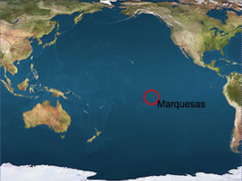
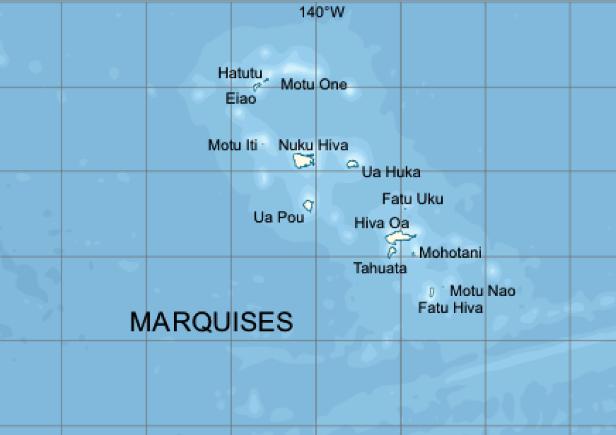
4 From Samoa to the Marquesas After the Polynesians reached Samoa about 1500 BC, we don t hear from them again until about 100 AD When we do, they show up in the easternmost island group in the entire Pacific -- the Marquesas Interestingly, the author s computer simulation of early sailing in the Pacific, which he first tested in 1985, replicated this finding perfectly


5 The Rising Point of Aldebaran Was a Safe Guide to the Marquesas
6
7

8 Another Computer Finding What the computer simulation also revealed was that if, by chance, the Marquesas were bypassed by the Polynesians, their next landfalls would likely be either the Galápagos Islands or the coast of southern Ecuador Coming ashore at the latter point would have brought them in contact with the Cañarí Indians, who not only grew sweet potatoes but also called them kumara!

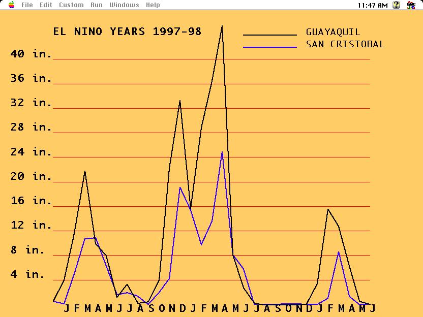
9 The Author Visits Ecuador in 1982 My second research trip to Ecuador in 1982 happened to coincide with an El Niño year, when heavy rains moved in from the Pacific to the west They accompany a back-wash of the Equatorial Counter-Current from eastern Asia, and recur every six to seven years


10 New Odds for Reaching America This means that, if the Polynesians had been out sailing in an El Niño year -- which occurs about 16% of the time -- they would have had tail-winds right into the coast of southern Ecuador -- a situation of which Heyerdahl was obviously not aware
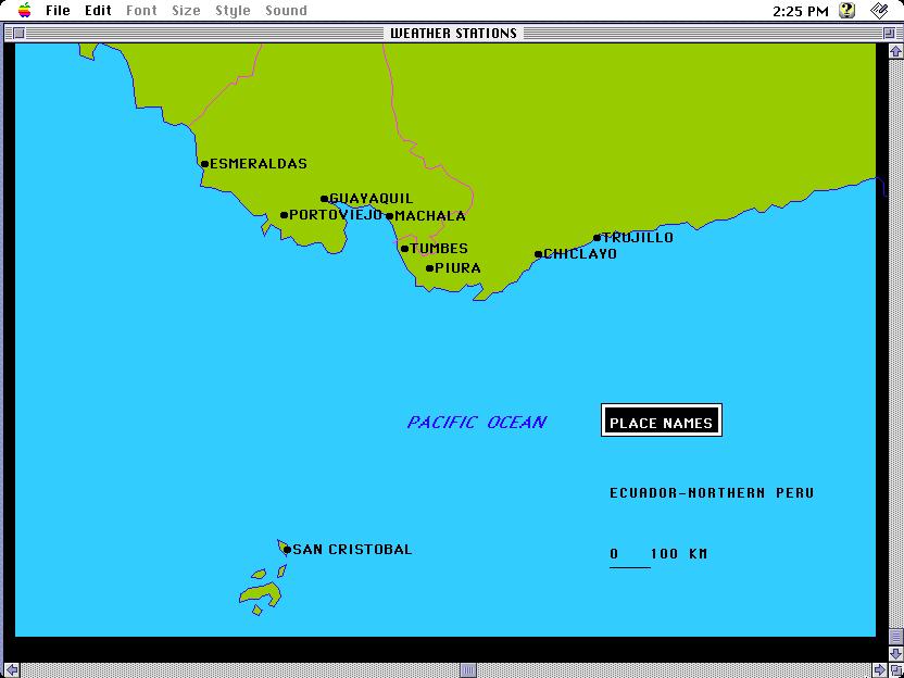
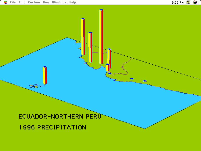
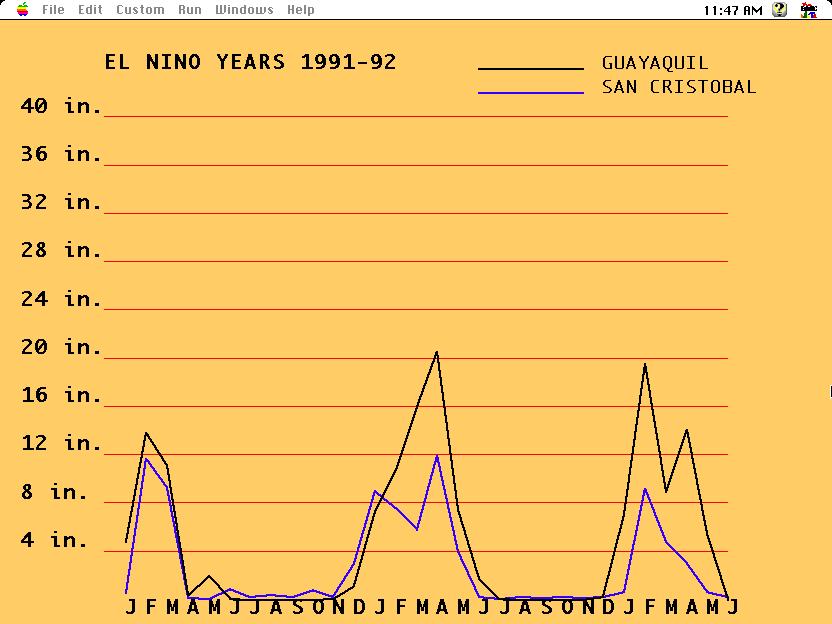
11 The Earliest Clues Show Up to the West When an El Niño back-wash occurs, the earliest places to feel its effects will be out to the west of Ecuador, in the Galápagos Islands To test this notion, the author investigated the latest decade of climatic data from the areas most likely to be affected; the place that turned out to always bear the brunt of these events is the Ecuadorean seaport of Guayaquil
12
13
14
15
16
17
18
19
20
21
22
23
24
25
26
27
28
29
30
31

32

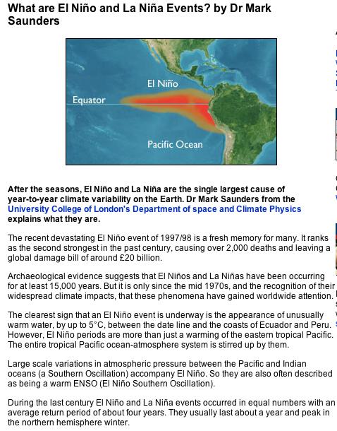
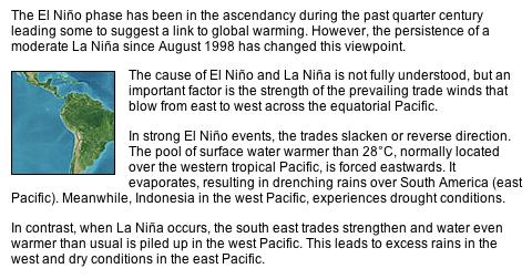
33 The Coastal Effects of El Niño When the Equatorial Counter-Current reaches South America, part of it branches northward along the coast of Ecuador and Colombia where it joins a flow of warm water and part of it branches southward along the coast of Peru where it floats on top of a very cold current
34 The Impact on Peru is Serious The warm southward flowing branch kills off the plankton in the cold water, a source of food for large schools of fish which are also the source of food for sea-birds As this ecological catastrophe unfolds, fish catches often drop by 2/3 during an El Niño event, seriously affecting the local economy


35 The Following Slides Trace El Niño Toward the South The coastal rain falls off sharply as the warm water is chilled by the cold current below From its peak in the Guayaquil area, it declines to almost nothing within a couple hundred miles The Atacama desert extends along the entire coast of Peru and the northern third of Chile, a barren strip of sand and rock punctuated by about 40 small river valleys
36
37
38
39
40


41 The Warm Northward Branch Brings Rains Along the Ecuadorean Coast Porto Viejo and Esmeraldas illustrate the effect along this stretch of coast The native vegetation here changes from desert to scrub to full-fledged tropical rain forest in just a matter of a few miles
42
43
44
45

46 Ecuador s Unique Geographic Location
47
48

49 During El Niño Events, the Rain Belt Shifts Eastward

50 During La Niña Events, the Rain Belt Shifts Westward


51 White areas = Warm Water Purple areas = Cold Water


52 Cyclical Variations in Pacific Water Temperatures
53 Temperature Monitoring System
54 A Case Study of the 1982 El Niño The morning that my student assistant and I were leaving Quito, the capital of Ecuador, for Guayaquil, its main port on the Pacific, the local newspapers told of three little boys, playng in the street, having been washed away the night before by a torrent of rainwater -- never to be found again!
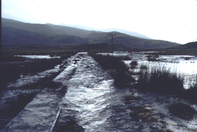
55 Our Rail Journey to the Coast Our train consisted of a Blue Bird school bus fitted with railway wheels and holding a total of 44 passengers As we began our climb out of Quito, the little stream alongside the track was about 6-8 feet wide By the time we reached the pass, it was a roaring river about 300 feet wide
56 The Moment of Decision The driver had to stop where the river crossed the rail-line, because it wasn t obvious if the tracks were still there As we waited for the water to drop, a dead bull and several large logs floated by Although the tracks were clogged with debris, the driver gunned it and we made it across, to the applause of the passengers

57 The Train or Auto-Ferro

58 The Challenge

59 Although we don t know the real number of casualties of the 1982 El Niño, that of 1998 is reckoned to have been responsible for over 2000 deaths -- most of them well beyond the borders of Ecuador and Peru, where it had its most immediate impact The End
A funny sounding lake. South American Landforms, Climate, and Vegetation
 A funny sounding lake South American Landforms, Climate, and Vegetation 3 4 Essential Question: How have physical features and climate affected the population distribution of Latin America? 5 I. Landforms
Latin America. Physical Geography
 Latin America Physical Geography Regions Latin America can be divided into separate regions based on physical geography or cultural geography. Regions If we look at physical geography Latin America has
Friday, November 10, 2017
 Friday, November 10, 2017 Andes and Midlatitude Countries Objective: Summarize the main physical features and regions of the Southern Cone. Identify and locate the urban centers and understand the pattern
The Lesser Antilles. Dominican Republic), and Puerto Rico
, and Puerto Rico") The Caribbean Islands are archipelagoes or groups of islands. The major archipelagoes are: The Greater Antilles - Cuba, Jamaica, Hispaniola (Composed of Haiti and the Dominican Republic), and Puerto Rico
The Caribbean Islands are archipelagoes or groups of islands. The major archipelagoes are: The Greater Antilles - Cuba, Jamaica, Hispaniola (Composed of Haiti and the Dominican Republic), and Puerto Rico
Essential Questions. 1. How have historical figures and events affected South America today?
 South America Essential Questions 1. How have historical figures and events affected South America today? 2. How has location affected the development of countries in South America? 3. How has the role
World Geography Ch. 7.2 Climate Regions of Latin America
 World Geography Ch. 7.2 Climate Regions of Latin America BR: D10 When you think of Latin America, what types of climates do you think are down there? Write down which of the following you believe are there:
What endures from the ancient civilizations that ruled the Andes?
 What endures from the ancient civilizations that ruled the Andes? By Smithsonian Institution, adapted by Newsela staff on 07.19.17 Word Count 1,113 Level 1020L Archaeological site in Moray, Peru, where
Latin America s Physical Geography. EQ: What are characteristics of Latin America s physical features?
 Latin America s Physical Geography EQ: What are characteristics of Latin America s physical features? Your Task: We are going to participate in a Museum Walk! You will travel around the room with a partner
6th Grade Social Studies Chapter 7: The Geography and Early Settlement of Egypt, Kush and Canaan
 I. Introduction (7.1) A. Egyptians settled along the Nile River, in the NE corner of Africa B. civilization lasted from around 3100 B.C. to 350 C. E. C. Kushites settled to the south of Egypt, along the
South America. pg. 520 (5 th) pg. 523 (6 th )
 pg. 523 (6 th )") South America pg. 520 (5 th) pg. 523 (6 th ) Venezuela Rich in Oil Lake Maracaibo Called Little Venice pg. 572 (5 th) pg. 574 (6 th ) Caracas 8 miles Inland 3000 pg. 572 (5 th) pg. 574 (6 th ) Caracas
South America pg. 520 (5 th) pg. 523 (6 th ) Venezuela Rich in Oil Lake Maracaibo Called Little Venice pg. 572 (5 th) pg. 574 (6 th ) Caracas 8 miles Inland 3000 pg. 572 (5 th) pg. 574 (6 th ) Caracas
Latin America. Introduction
 Latin America Introduction What are the 5 Themes of Geography? Draw lines to connect the theme to the definition: Location How humans and the environment impact each other Physical and human characteristics
GEOGRAPHY AND HISTORY
 GEOGRAPHY AND HISTORY YEAR 1, PART 1 www.vicensvives.es Contents 01 Our planet Earth 02 The representation of the Earth: maps 03 The Earth s relief 04 Rivers and seas 05 Weather and climate 06 Climates
Oceania. Australia, New Zealand, and the Pacific Islands. Physical Geography. Where is Australia located?
 Oceania Australia, New Zealand, and the Pacific Islands Physical Geography Australia New Zealand Oceania Where is Australia located? Australia & Oceania are a group of islands located between Asia, Antarctica,
The Land Photo Source: The Atlas of Canada, The Red River, Manatoba, Canada land/physio_red_ri
 The Land The United States and Canada An Overview of the Region The United States and Canada are the two largest countries in North America. The Rio Grande is part of the southwest border of the United
Geographic Qualities of South America
 Geographic Qualities of South America 1. South America is the fourth largest continent in area. It is located in the Western Hemisphere, lying southwest of North America. Most of South America lies in
Chapter 20. The Physical Geography of Africa South of the Sahara
 Chapter 20 The Physical Geography of Africa South of the Sahara Chapter Objectives Identify the major landforms, water systems, and natural resources of Africa south of the Sahara. Describe the relationship
Portuguese Language - Fostering National Unity
 Geography Brazil Brazil Portuguese Language - Fostering National Unity 11 dialects of Portuguese Influenced by Amerindian and African languages, creating differences between Portuguese spoken in Brazil
Chapter 7 Geography and the Early Settlement of Egypt, Kush, and Canaan
 Chapter 7 Geography and the Early Settlement of Egypt, Kush, and Canaan How did geography affect early settlement in Egypt, Kush, and Canaan? Section 7.1 - Introduction RF/NASA//Corbis This satellite photograph
THE GEOGRAPHY OF THE NILE. Section 1
 THE GEOGRAPHY OF THE NILE Section 1 The Nile River is the world s longest river. It flows north from its sources in East Africa to the Mediterranean Sea for more than 4,000 miles. THE COURSE OF THE NILE
Mrs. Reifsnyder World Geography. Unit 8: Latin America Study Guide SOLs Addressed: WG. 1c, 2b, 3c, 4, 10b/c
 Mrs. Reifsnyder World Geography Unit 8: Latin America Study Guide SOLs Addressed: WG. 1c, 2b, 3c, 4, 10b/c Essential Questions: - In what ways do physical, economic, and cultural characteristics influence
Countries Of The World: Mexico
 Countries Of The World: Mexico By National Geographic Kids, adapted by Newsela staff on 06.07.18 Word Count 659 Level MAX Image 1: The pyramids of Guachimontones in Jalisco, Mexico. Mexico is a country
MEETING OF THE ECLAC AD HOC COMMITTEE ON POPULATION AND DEVELOPMENT. Quito, Ecuador, 4-6 July 2012 GENERAL INFORMATION
 MEETING OF THE ECLAC AD HOC COMMITTEE ON POPULATION AND DEVELOPMENT Quito, Ecuador, 4-6 July 2012 GENERAL INFORMATION 1 INTRODUCTION The meeting of the ECLAC Ad Hoc Committee on Population and Development
South American Countries. Capital Location Population Terrain Climate
 South American Countries Capital Location Population Terrain Climate Andes Mountains Four large areas that make up the Central Plains: Llanos, the Selva, the Gran Chaco, and the Pampas Brazilian Highlands
THE TWENTY FIRST ANNUAL SOUTHERN AFRICA REGIONAL CLIMATE OUTLOOK FORUM MID-SEASON REVIEW AND UPDATE
 STATEMENT FROM THE TWENTY FIRST ANNUAL SOUTHERN AFRICA REGIONAL CLIMATE OUTLOOK FORUM (SARCOF-21) MID-SEASON REVIEW AND UPDATE, SADC HEADQUARTERS, GABORONE, BOTSWANA, 5 8 DECEMBER 2017. SUMMARY The bulk
19 th century. 20 th century. 21 th century
 Easter island Information Easter Island is a Polynesian island in the southeastern Pacific Ocean, at the southeastern most point of the Polynesian Triangle. Easter Island is famous for its 887 extant monumental
Ecuador at a Glance. Quito. Capital: 276,840 sq km. Land: US dollar (USD) Currency (code): 1 the US dollar is used; the sucre was eliminated in 2000
 Currency (code): 1 the US dollar is used; the sucre was eliminated in 2000") Capital: Quito Land: 276,840 sq km Currency (code): US dollar (USD) Exchange rates: 1 the US dollar is used; the sucre was eliminated in 2000 Population: 13,755,680 (July 2007 est.) Age structure: 0-14
Capital: Quito Land: 276,840 sq km Currency (code): US dollar (USD) Exchange rates: 1 the US dollar is used; the sucre was eliminated in 2000 Population: 13,755,680 (July 2007 est.) Age structure: 0-14
Rivers. Highlights of some of the World s Most Famous Rivers!
 Rivers Highlights of some of the World s Most Famous Rivers! Directions This Power Point presentation contains information about some of the most famous rivers in the world! Students should use this presentation
Lecture #1: Introduction
 Anthropology G4210 The Rise of Andean Civilization T. D'Altroy September 8, 1999 Lecture #1: Introduction 1. purposes of the course a. examination of the nature and development of societies in the Andes
STUDY GUIDE. The Land. Physical Features of Latin America. Chapter 8, Section 1. Terms to Know DRAWING FROM EXPERIENCE ORGANIZING YOUR THOUGHTS
 For use with textbook pages 193 198. The Land Terms to Know cordillera A mountain range that runs parallel to another mountain range (page 194) altiplano A high plain (page 194) escarpment A steep cliff
Introduction to Africa
 Introduction to Africa Did you know? Africa has more countries than any other continent. The Sahara is a desert that is the size of the U.S. It s the world's largest desert. Most of the world s gold and
CH. 1 Europe and Russia: Physical Geography. Section 1 Land and Water p Europe and Russia are part of the world s largest landmass called.
 CH. 1 Europe and Russia: Physical Geography Section 1 Land and Water p.10-16 Europe and Russia are part of the world s largest landmass called. The country of Russia stretches over both continents. About
World History: Patterns of Interaction
 The Americans: A Separate World, 40,000 B.C. A.D. 700 Although early American civilizations remain mysterious, we know that the earliest Americans most likely migrated from Asia and that complex cultures
EMERGENCY INTERVENTION AFTER ECUADOR EARTHQUAKE
 ECUADOR EARTHQUAKE EMERGENCY INTERVENTION AFTER ECUADOR EARTHQUAKE April 16, 2016 Emergency Type: Emergency Overview April 19, 2016 Earthquake Emergency Date: April 16, 2016 Location: Emergency effects:
Social Studies: The World
 Social Studies: The World What is the name of the continent that is labeled #1 on the map? North America What is the name of the continent that is labeled #2 on the map? South America What is the name
THE PHYSICAL AND CULTURAL GEOGRAPHY OF SOUTH AMERICA
 THE PHYSICAL AND CULTURAL GEOGRAPHY OF SOUTH AMERICA 1 Global location Relative to European capitals Relative to US cities Time zones Two oceans Pacific rim countries - farther to Asia than USA Not on
Chapter 7. Geography and the Early Settlement of Egypt, Kush, and Canaan
 Chapter 7 Geography and the Early Settlement of Egypt, Kush, and Canaan Chapter 7 Geography and the Early Settlement of Egypt, Kush, and Canaan How did geography affect early in Egypt Kush, and Canaan?
High-Interest/Low-Readability Nonfiction. Extreme Places. by Kathryn Wheeler. Carson-Dellosa Publishing Company, Inc. Greensboro, North Carolina
 High-Interest/Low-Readability Nonfiction Extreme Places by Kathryn Wheeler Carson-Dellosa Publishing Company, Inc. Greensboro, North Carolina Credits Editors: Ashley Anderson and Carrie Fox Layout Design:
Latin America. Chapter 9 Physical Geography
 Latin America Chapter 9 Physical Geography Latin American Regions Middle America includes Mexico and the Central American countries The Caribbean Islands South America Mexico Landforms Sierra Madre Oriental
Chapter 17. North Africa, Southwest Asia and Central Asia
 Chapter 17 North Africa, Southwest Asia and Central Asia Chapter Objectives Describe the major landforms and natural resources of North Africa, Southwest Asia, and Central Asia. Discuss the climate and
Location, Climate, & Natural Resources Brain Wrinkles
 Location, Climate, & Natural Resources Standards SS6G10 The student will explain the impact of location, climate, natural resources, and population distribution on Europe. a. Compare how the location,
The Coasts Of Chile, Bolivia, And Peru By Anon
 The Coasts Of Chile, Bolivia, And Peru By Anon If you are searching for a book by Anon The Coasts of Chile, Bolivia, and Peru in pdf format, then you have come on to the faithful site. We furnish full
Month June 2011 South America (except Colombia for HA) Date of submission 01/07/11 MONTHLY REPORT
 Date of submission 01/07/11 MONTHLY REPORT") ANNEX IV-3 EUROPEAN COMMISSION HUMANITARIAN AID OFFICE (ECHO) Monthly report number 2011/6 Month June 2011 Country South America (except Colombia for HA) Date of submission 01/07/11 Author ECHO Quito MONTHLY
ANNEX IV-3 EUROPEAN COMMISSION HUMANITARIAN AID OFFICE (ECHO) Monthly report number 2011/6 Month June 2011 Country South America (except Colombia for HA) Date of submission 01/07/11 Author ECHO Quito MONTHLY
Economy 3. This region s economy was based on agriculture. 4. This region produced items such as textiles, iron, and ships in great quantities. For th
 Geography 1. This region has a climate of warm summers and snowy cold winters. 2. This region has a climate that is generally warm and sunny, with long, hot, humid summers, and mild winters, and heavy
WORLD GEOGRAPHY. Hector Rodriguez
 Mr. Chavira 9th Period WORLD GEOGRAPHY Hector Rodriguez P a g e 1 Table of Contents Latin America Page 2 o Maps Economic Map Page 3 Political Map Page 4 Population Map Page 5 Physical Page 6 o Notes Physical
South America Projects
 South America Projects Study the geography of South America by choosing one of the activities below. South American Travel Brochure Explorer s Journal World Cup Geography Create a Playable Board Game Create
Introduction. We hope you find these materials useful and would welcome any feedback.
 Introduction This planning pack was produced with teachers from County Durham following a visit to São Paulo. The materials support the teaching of geography at key stage one and two within the context
Biosphere reserves: a tool for the management of coastal zones and islands in the Latin American Pacific
 Biosphere reserves: a tool for the management of coastal zones and islands in the Latin American Pacific MIGUEL CLÜSENER-GODT Director (a.i.), Division of Ecological and Earth Sciences Secretary (a.i.),
INTRODUCTION ITINERARY ECUADOR - QUITO TRIP CODE ECTSQGL DEPARTURE DURATION. 4 Days LOCATIONS. Quito, Guayaquil
 INTRODUCTION The Chimu Collections range consists of boutique properties, cruises & itineraries, throughout Latin America, designed for travellers seeking unique experiences. Tren Crucero is the most stunning
Location, Climate, & Natural Resources. Where People Live & How They Trade
 Location, Climate, & Natural Resources Where People Live & How They Trade Standards SS6G13 The student will explain the impact of location, climate, distribution of natural resources, and population distribution
Aviation Competitiveness. James Wiltshire Head of Policy Analysis
 Aviation Competitiveness James Wiltshire Head of Policy Analysis 1 Air Connectivity and Competitiveness Aviation is a major enabler of economic activity and social cohesion Air Connectivity drives economic
Land and People of Peru and Ecuador
 Guide to Reading Main Idea Peru and Ecuador share similar landscapes, climates, and history. Terms to Know navigable foothills empire Reading Strategy Create two ovals like these. Under each heading, list
CHAPTER 12. South America. Section 1: Natural Environments Section 2: History and Culture Section 3: South America Today. HOLT World Geography
 CHAPTER 12 South America Section 1: Natural Environments Section 2: History and Culture Section 3: South America 1 Section 1 Natural Environments Objectives: What are the major landforms and rivers of
Australian Geography. Standards:
 Australian Geography Standards: SS6G12 The student will be able to locate selected features of Australia. a. Locate on a world and regional political-physical map: the Great Barrier Reef, Coral Sea, Ayers
EUROPEAN COMMISSION DIRECTORATE-GENERAL HUMANITARIAN AID AND CIVIL PROTECTION - ECHO
 EUROPEAN COMMISSION DIRECTORATE-GENERAL HUMANITARIAN AID AND CIVIL PROTECTION - ECHO Monthly report number 2013/10 Month OCTOBER Country South America (except Colombia for HA) Date of submission 08/11/13
Chapter 16 ~ Eastern Mediterranean
 Chapter 16 ~ Eastern Mediterranean Physical Geography of the Eastern Mediterranean Landforms This area is known as the Levant and includes Syria, Jordan, Lebanon, Israel, and the Palestinian territories.
STUDY GUIDE. The Land. Chapter 29, Section 1. Both. Terms to Know DRAWING FROM EXPERIENCE ORGANIZING YOUR THOUGHTS
 Chapter 29, Section 1 For use with textbook pages 719 724. The Land Terms to Know cordilleras Parallel mountain ranges and plateaus (page 719) archipelago A group of islands (page 720) insular Relating
SS8G1 The student will describe Georgia with regard to physical features and location.
 SS8G1ab Standards SS8G1 The student will describe Georgia with regard to physical features and location. a. Locate Georgia in relation to the region, nation, continent, and hemispheres. b. Describe the
Brain Wrinkles. Location, Climate, & Natural Resources of. Where People Live & How They Trade
 Location, Climate, & Natural Resources of Where People Live & How They Trade It s south of the US, east of the Pacific Ocean, and west of the Gulf of Mexico & Caribbean Sea. It s great that it s located
September. ECHO Quito team MONTHLY REPORT
 EUROPEAN COMMISSION HUMANITARIAN AID OFFICE (ECHO) Monthly report number 2012/09 Month Country September South America (except Colombia for HA) Date of submission 04/10/12 Author ECHO Quito team 1. SUMMARY
How the Nile River Led to Civilization in Ancient Egypt
 How the Nile River Led to Civilization in Ancient Egypt By USHistory.org, adapted by Newsela staff on 03.07.17 Word Count 786 Level 950L TOP: This photo, taken around 1915, shows the flooding of the Nile
The Geography of Climate
 The Geography of Climate Objective for Today: Today we will examine ways that latitude and landforms influence climate The focus of our study will be the South American Continent in the Formal Region known
Our lives. Inés Mehmet Leila. What you will do. Do you know which countries these people come from? What do you know about these countries?
 1 Our lives Do you know which countries these people come from? What do you know about these countries? What you will do Inés Mehmet Leila This unit is about life in different countries. These are the
Latin America. Physical Geography
 + Latin America Physical Geography + I. Landforms A. Caribbean & Central America 1. Mexico is dominated by two mountain chains, collectively called the Sierra Madre. A high plateau is situated in between.
ADVENTURE TOURS. Inca Trail Salkantay Choquequirao
 ADVENTURE TOURS Inca Trail Salkantay Choquequirao Inca Trail One of thr most fascinating trekking routes in the world 4 days 3 nights Ecuador Colombia Brazil Pacific Ocean Lima Machu Picchu Urubamba Cuzco
STANDARDS: Brain Wrinkles
 STANDARDS: SS6G3 The student will explain the impact of location, climate, distribution of natural resources, and population distribution on Latin America and the Caribbean. a. Compare how the location,
THE TWENTIETH ANNUAL SOUTHERN AFRICA REGIONAL CLIMATE OUTLOOK FORUM
 STATEMENT FROM THE TWENTIENT ANNUAL SOUTHERN AFRICA REGIONAL CLIMATE OUTLOOK FORUM (SARCOF-20), HARARE INTERNATIONAL CONFERENCE CENTRE, HARARE, ZIMBABWE, 24 26 AUGUST 2016. SUMMARY The bulk of Southern
CHAPTER Latin America. Regional Atlas Study Guide. 2 Chapter A. As You Read. B. Reviewing Vocabulary
 CHAPTER 28 9 Many Th ew inventions new Regional Atlas Study Guide Latin America Directions: As you work through the Regional Atlas, complete the chart below by writing two details about each Latin American
Expedition to the Amazon Rainforest Southbound
 Expedition to the Amazon Rainforest Southbound Manaus, Brazil - Montevideo, Uruguay Combine Amazon rainforest, tropical beaches and metropolitan city life along the Brazilian coast. Departing from Manaus,
1st Period Mr. Chavira WORLD GEOGRAPHY. Hector Rodriguez
 1st Period Mr. Chavira WORLD GEOGRAPHY Hector Rodriguez P a g e 1 Table of Contents Latin America Page 2 o Maps Economic Map Page 3 Political Map Page 4 Population Map Page 5 Physical Page 6 o Notes Physical
ECOREGIONAL ASSESSMENT EQUATORIAL PACIFIC EXECUTIVE SUMMARY
 ECOREGIONAL ASSESSMENT EQUATORIAL PACIFIC The Nature Conservancy, Fundación Agua, EcoCiencia, Fundación Jatun Sacha, CDC Ecuador, CDC UNALM 2004. Portafolio de Sitios Prioritarios para la Conservación
Lesson 1: The Lifeline of the Nile
 Lesson 1 Summary Lesson 1: The Lifeline of the Nile Use with pages 78 81. Vocabulary delta a triangular-shaped area of soil at the mouth of a river silt a mixture of soil and small rocks papyrus a plant
TRAIN OF WONDERS. Quito Guayaquil 4 days 4 nights Tuesday to Friday
 TRAIN OF WONDERS Quito Guayaquil 4 days 4 nights Tuesday to Friday Our journey begins in the northern Andes of Ecuador, in the valley of Otavalo, where we will discover traditional cultures, handicrafts,
Countries Of The World: Mexico
 Countries Of The World: Mexico By National Geographic Kids, adapted by Newsela staff on 06.07.18 Word Count 638 Level 800L Image 1: The pyramids of Guachimontones in Jalisco, Mexico. Mexico is a country
LAST TIME (Happy 300 th Birthday Ben Franklin!)
") LAST TIME (Happy 300 th Birthday Ben Franklin!) Latin American Diversity: Introduction Physical Geography of Mexico, Caribbean, and Central America: 1. Mexican drylands 2. Mesoamerican Highlands 3. Coastal
LAST TIME (Happy 300 th Birthday Ben Franklin!) Latin American Diversity: Introduction Physical Geography of Mexico, Caribbean, and Central America: 1. Mexican drylands 2. Mesoamerican Highlands 3. Coastal
Chapter 16 ~ Eastern Mediterranean
 Chapter 16 ~ Eastern Mediterranean Physical Geography of the Eastern Mediterranean Landforms This area is known as the Levant and includes Syria, Jordan, Lebanon, Israel, and the Palestinian territories.
2. The most important crop in Mexico. 3. The Priest who spoke against Spain. 5. Ancient Aztec city, now Mexico City
 Name: Date: Did you hear about what happened at the laundromat last night? Three clothespins held up two shirts! Clues are listed below. Print the word that matches the clue on the blank line by the clue.
ì<(sk$m)=beicea< +^-Ä-U-Ä-U
=beicea< +^-Ä-U-Ä-U") Fascinating Facts The Nile River in Egypt is the world s longest river, but the Amazon River in Brazil moves the most water. The world s largest freshwater lake is Lake Baikal in Russia. The highest temperature
Fascinating Facts The Nile River in Egypt is the world s longest river, but the Amazon River in Brazil moves the most water. The world s largest freshwater lake is Lake Baikal in Russia. The highest temperature
Maggie s Weekly Activity Pack!
 Maggie s Weekly Activity Pack! Name Date Remembering A Great Adventure The Journey of Lewis and Clark It has been two hundred years since Lewis and Clark started their journey across America. In February
Chapter 4. Daily Focus Skills
 Chapter 4 Daily Focus Skills Chapter 4 On a historical map of the ancient Mediterranean area, locate Greece and trace the boundaries of its influence to 300 BC/BCE. Explain how the geographical location
City of San Bernardino Historical and Pioneer Society P.O. Box 875, San Bernardino, CA 92402
 City of San Bernardino Historical and Pioneer Society P.O. Box 875, San Bernardino, CA 92402 LIBRARY NEWS MAY 2009 By Richard D. Thompson, Librarian ARROWHEAD SPRINGS WATER By Ronnie Featherstone. Arrowhead
MACHU PICCHU ONE DAY TRIP
 MACHU PICCHU ONE DAY TRIP MACHU PICCHU ONE DAY TRIP Not having much time is no impediment to not visit Machupicchu, this is the option of one day tour to visit the Inka Citadel of Machupicchu; Choose the
What Is An Ecoregion?
 Ecoregions of Texas What Is An Ecoregion? Ecoregion a major ecosystem with distinctive geography, characteristic plants and animals, and ecosystems that receives uniform solar radiation and moisture Sometimes
LOCATION, CLIMATE, AND NATURAL RESOURCES OF MEXICO
 SS6G3 The student will explain the impact of location, climate, distribution of natural resources, and population distribution on Latin America and the Caribbean. a. Compare how the location, climate,
How the Nile River Led to Civilization in Ancient Egypt
 How the Nile River Led to Civilization in Ancient Egypt By USHistory.org on 03.07.17 Word Count 1,108 Level MAX TOP: This photo, taken around 1915, shows the flooding of the Nile River, which happens each
The Earliest Americans
 The Earliest Americans A Land Bridge Section The Earliest Americans The cultures of the first Americans, including social organization, develop in ways similar to other early cultures. The American Continents
Project Summary. Project Overview
 Don't let its size fool you; Ecuador has so much to offer. To the east lies vast stretches of rainforest jungle - part of the Amazon Basin and home to so many of Ecuador's indigenous people. In the central
Location, Climate, & Natural Resources
 Location, Climate, & Natural Resources UK is a country of islands off the coast of mainland Europe. It consists of England, Northern Ireland, Scotland, & Wales. UK s location makes it a HUB for trade.
Indonesia Orangutan Conservation (Sumatra)
") Indonesia Orangutan Conservation (Sumatra) Travel in a small group, staying in remote forest camps, as you track orangutans and other fascinating native species on this research project, vital to developing
Indonesia Orangutan Conservation (Sumatra) Travel in a small group, staying in remote forest camps, as you track orangutans and other fascinating native species on this research project, vital to developing
Objective. Students will familiarize themselves with the physical features and climates of Latin America.
 Journal Write KWL What do you KNOW about Latin America? What do you WANT TO KNOW about Latin America? What did you LEARN today that you didn t know before? Latin America Objective Students will familiarize
Name: Hour: Day: The Land and Its Regions (pg ) Define, in your own words, escarpment. Define, in your own words, sertão
 Define, in your own words, escarpment. Define, in your own words, sertão") Name: Hour: Day: World Geography Guided Reading Notes Chap 12 & 13 --- ANSWER IN COMPLETE SENTENCES!!!! READ EACH QUESTION CAREFULLY & ANSWER COMPLETELY!!!! Objectives: Upon completion of reading you should
Name: Hour: Day: World Geography Guided Reading Notes Chap 12 & 13 --- ANSWER IN COMPLETE SENTENCES!!!! READ EACH QUESTION CAREFULLY & ANSWER COMPLETELY!!!! Objectives: Upon completion of reading you should
The Geological Pacific Northwest. Wednesday February 6, 2012 Pacific Northwest History Mr. Rice
 The Geological Pacific Northwest Wednesday February 6, 2012 Pacific Northwest History Mr. Rice 1 Free Response #2 Please do not simply list the items for this response. Full sentences!!! Minimum of 3-5
Latin America 11/4/2013. Latin America Today. 580 million people 9% of the world s population Diverse backgrounds:
 Latin America Chapter 10 Human Geography Latin America Today 580 million people 9% of the world s population Diverse backgrounds: Native Americans Europeans Africans Asians 1 Population 393 million live
Ecuador And Galapagos (Tour Details, Maps, Physical/cultural Details)
") Ecuador And Galapagos (Tour Details, Maps, Physical/cultural Details) If searching for the book Ecuador and Galapagos (Tour details, maps, physical/cultural details) in pdf format, then you have come on
Ecuador And Galapagos (Tour Details, Maps, Physical/cultural Details) If searching for the book Ecuador and Galapagos (Tour details, maps, physical/cultural details) in pdf format, then you have come on
The Complete Spitsbergen Expedition
 The Complete Spitsbergen Expedition Longyearbyen, circumnavigating Svalbard (flights from Oslo) This Arctic expedition is one of a kind! We will sail above 80º N, to take you to the ice edge of the Arctic
St. Christopher Camp and Conference Center s Outdoor education program for elementary and middle school students
 St. Christopher Camp and Conference Center s Outdoor education program for elementary and middle school students Since 1980, The Barrier Island Environmental Education Program has provided thousands of
Technical Meeting: Meeting Of Procurement and Hiring Managers. September 6th-7th 2012
 Technical Meeting: Meeting Of Procurement and Hiring Managers September 6th-7th 2012 Geographical location is situated in the southeastern quadrant of the Pacific Ocean and settles its territory at the
Unit 4: The Americas
 Unit 4: The Americas South America Main Idea Several early cultures in South America adapted to extreme environmental condi:ons. One of them, the Inca, built one of the biggest and most powerful empires
THE TWENTY FIRST ANNUAL SOUTHERN AFRICA REGIONAL CLIMATE OUTLOOK FORUM
 STATEMENT FROM THE TWENTY FIRST ANNUAL SOUTHERN AFRICAN REGIONAL CLIMATE OUTLOOK FORUM (SARCOF-21), MASA CONFERENCE CENTRE, GABORONE, BOTSWANA, 23 25 AUGUST 2017. SUMMARY The bulk of Southern African Development
Regional Atlas: Introduction to Latin America
 Chapter 9, Section World Geography Chapter 9 Regional Atlas: Introduction to Latin America Copyright 2003 by Pearson Education, Inc., publishing as Prentice Hall, Upper Saddle River, NJ. All rights reserved.
STUDY GUIDE. The Land. Chapter 17, Section 1. There are frequent earthquakes in the region. Petroleum is a major export in the region.
 For use with textbook pages 421 426. The Land Terms to Know alluvial soil A rich soil made up of sand and mud deposited by flowing water (page 423) wadi A streambed that remains dry until a heavy rain