Vespucci world map #338
|
|
|
- Cameron Gilmore
- 6 years ago
- Views:
Transcription
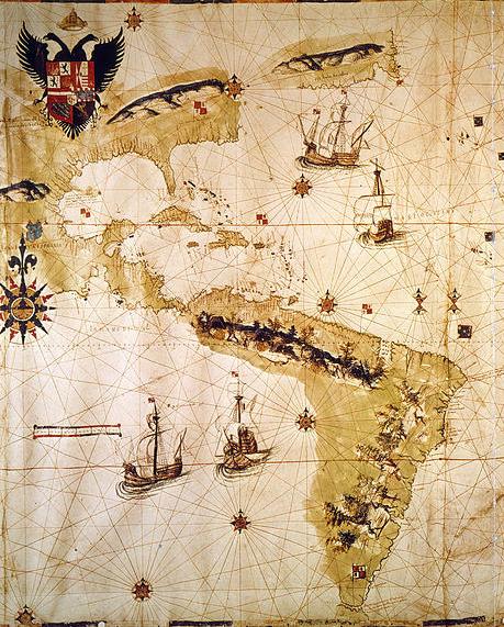
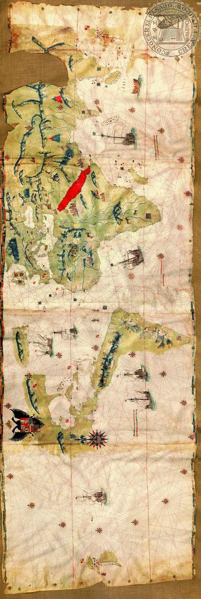
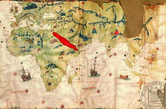
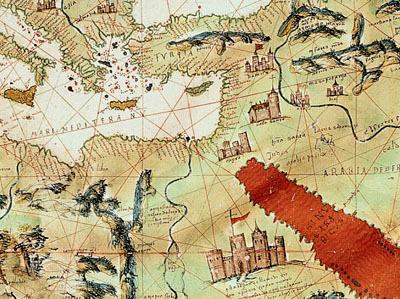
![Vespucci world map Title: Vespucci world map Date: 1526 Author: Juan [Giovanni] Vespucci Description: This large illustrated manuscript planisphere on vellum presents the first cartographic record of](/docs-images/75/72476065/images/1-0.jpg "exploration in North America after the portrayal of the Cabot landfall on the la Cosa chart (#305).")
1 Vespucci world map Title: Vespucci world map Date: 1526 Author: Juan [Giovanni] Vespucci Description: This large illustrated manuscript planisphere on vellum presents the first cartographic record of exploration in North America after the portrayal of the Cabot landfall on the la Cosa chart (#305). The mapmaker, Juan [Giovanni] Vespucci, nephew of Amerigo Vespucci, had made several voyages to American waters, according to Peter Martyr, the first Spanish historian of the Indies. After Amerigo s death at Seville in 1512, Juan, who had inherited his famous uncle s maps, charts, and nautical instruments, was appointed to Amerigo s former position as official Spanish government Pilot at Seville. Juan soon became as important as his uncle in the management of geographical information from Spain s overseas activities. Juan was a member of the council to improve existing charts and the Badajoz-Elvas Commission of 1524, which attempted to resolve Portuguese Spanish claims in the East Indies. During the same year that Vespucci produced this map, he was appointed Examiner of Pilots, replacing the ubiquitous Sebastian Cabot who was then leading an expedition in Brazil. The Spanish reported little progress in the exploration of North America during the following two decades. Juan Ponce de Leon had been in Florida in 1513 searching for the legendary Fountain of Youth and had made an important contribution by describing the Gulf Stream. Freelance slave-raiding trips in the Bahamas and perhaps on the Florida coast were the main activities until
2 In that year Lucas Vasquez Ayllón, prominent Santo Domingo leader, organized an expedition to explore lands thought to exist north of Florida. He sent out a ship under Francisco Gordillo that was joined by another under Pedro de Quexos. In June 1521 they landed at the mouth of a large river, which they named after St. John the Baptist. The two captains claimed the surrounding land for Spain and, against Ayllón s orders, took 150 natives back to Santo Domingo to be sold as slaves. Quexos s ship returned safely, but Gordillo s was lost at sea. Diego Columbus headed a royal investigation that ordered the surviving Indians returned to their homeland and released. Ayllón received a royal grant of the territory and title of governor. In 1525 he sent Quexos back to explore further, and the coastline was probed from Florida to just north of the Chesapeake Bay. Not until July 1526 did Ayllón and his party of colonists land on the Carolina coast at the estuary they called the Jordan River. The colony was a tragic failure, but the pioneering Spaniards left their mark on the American southeastern coast via Vespucci s map. St. Helena, a sound between Beaufort and Edisto Island reflects this: it is one of the oldest place-names still in use on the Atlantic coast. This manuscript map differs significantly from Vespucci s double-hemispheric world map with polar projection printed in The Hispanic Society map is constructed as a portolan chart with compass roses and rhumb lines across the entire surface. The chief compass rose, which extends into Mexico, illustrates the Portuguese influence in cartographic ornamentation during the 16 th century. As can be seen here, Africa, southern Europe, and Asia Minor are well known, also the coasts of Florida, Mexico, Central America and northern South America. On the east coast of the present United States, another Florentine, Giovanni da Verrazzano, has been credited with claiming New England for Francis l of France and for discovering New York Bay in Estêvão Gomes, a Portuguese pilot in the service of Spain, explored the coast as far north as Maine and the Penboscot River (R:desgamos). Vespucci himself had attended the meeting at Badajoz which authorized this expedition. The Bacalaos, now known as the Grand Banks, Cape Race in Newfoundland, Stag River and the land of the bartoas are recorded by Vespucci, along with the new land of Ayllón. This first settlement within the boundaries of the United States had been made by Lucas Vazquez de Ayllón of Toledo near the Santee River (R:Jordan) in South Carolina. The map is also notable as an expression of empire in Charles V s imperial coat of arms is placed above North America while flags of Castile and Leon (gold castles on a red ground and brown lions on a white ground) mark Spanish territories just as the Portuguese ones do for their holdings. Moreover, Vespucci includes many engaging details: eight galleons sailing the ocean, the Red Sea painted red, the tower of Babylon located in Persia, elephants and camels in Africa, indigenous natives in South America and the churches of the Holy Land. On this map Vespucci locates geographical features of which he is certain. Between Newfoundland and Nova Scotia, however, the area southward is blank until Ayllon [Carolina] is marked with a Spanish flag. Although none of the names from the original Gordillo and Quexos voyage appear and Ayllon s colonizing expedition had not returned when the map was produced, the second passage under Quexos in 1525 is reflected on the coastline. The area henceforth appears on maps as Nueva Terra di Ayllon. 2

3 One interesting place-name, Rio de sa verazanas, is shown between the Jordan River and the Chesapeake Bay. This implies that the explorations of Verrazzano, a Florentine sailing for the King of France, were known in Spain. The map is considered to be either a draft or copy of the official Spanish chart kept at Seville, initially called the padron real and later, padron general, it was on the padron that corrections and information of new discoveries were entered as reported under oath by returning pilots. Juan Vespucci provides on this outstanding manuscript map of the world the first documented details of coastal exploration north of Florida. The map is large enough that, unlike other maps of the period, does not avoid the issue of the areas north and south of Eurasia and the New World. The mapmaker clearly believed that Asia was separate from the new discoveries. This map is also one of the earliest surviving maps to mark unmistakably the new Strait of Magellan. Location: The Hispanic Society of America, New York Size: 85 x 26.2 cm; 33.5 x 103 inches References: *Cumming, W.P., The Southeast in Early Maps, no. 7-8, 16-17, Plate 2. *Cumming, W.P., R.A. Skelton & D.B. Quinn, The Discovery of North America, no. 87. *Nebenzahl, K., Atlas of Columbus and the Great Discoveries, pp *Whitfield, P., New Found Lands, pp. 60-1, 96. *Wroth, L.C., The Voyages of Giovanni da Verrazzano, , 197n. no. 36. *illustrated 3
4 4
5 5
6 6
Unit 11 Lesson 9 Great Voyages of Discovery
 Unit 11 Lesson 9 Great Voyages of Discovery Generalization: Contact can lead to conflict and cultural diffusion Big Idea -- The Age of Discovery would not have been possible without the emergence of Spain
Sebastian Cabot World Map
 Sebastian Cabot World Map Cartographer: Sebastian Cabot Date: 1544 Size: 124 x 210 cm Location: Biblitheque Nationale, Res. Ge.AA.582, Paris Description: According to R.W. Shirley, this magnificent elliptical
Spanish Colonies on the Borderlands
 Spanish Colonies on the Borderlands Pages 90 93 Nov 1 8:14 PM 1 Today's Objectives *Describe Spain s colony in Florida. *Explain how Spain established settlements throughout much of North America. *Describe
European Explorers Spain England France Portugal. "Other" countries = no color
 European Explorers 1200-1800 Spain England France Portugal "Other" countries = no color Marco Polo Biography Born = 1254 Died = 1324 Sponsor Country = Italy Years Explored: 1260-1295 Area Explored: Asia,
Journey Around the World with the Universal Atlas of Fernão Vaz Dourado
 OCTOBER 28, 2018 BY MEDIEVALISTS.NET Journey Around the World with the Universal Atlas of Fernão Vaz Dourado By João Carlos Garcia This atlas was made in 1571 by one of the finest Portuguese cartographers,
Victoria, the only ship of Magellan s fleet to complete the circumnavigation (from a 1590 map by cartographer Abraham Ortelius).
.") 1 2 3 4 5 6 7 Ferdinand Magellan was born in the European country of Portugal in 1480. He came from a wealthy family and as a young boy served as a page to Portugal s Queen Leonor for two years. He had
1 2 3 4 5 6 7 Ferdinand Magellan was born in the European country of Portugal in 1480. He came from a wealthy family and as a young boy served as a page to Portugal s Queen Leonor for two years. He had
CHRONOLOGY. of Colonialism in South America
 CHRONOLOGY of Colonialism in South America 1492 Columbus Sails for Spain Detail from: America Sive Novus Orbis, by Theodore de Bry, 1596 Image from: De Insulis nuper in mari Indico repertis, by Christopher
Chapter 10. Transoceanic Exploration (750 to 1500 CE)
") Chapter 10 Transoceanic Exploration (750 to 1500 CE) Muslim Domination of the Afro-Eurasian Region: 750 CE 1258 CE During the Abbasid Dynasty, Muslim rulers controlled most international trade routes in
Chapter 10 Transoceanic Exploration (750 to 1500 CE) Muslim Domination of the Afro-Eurasian Region: 750 CE 1258 CE During the Abbasid Dynasty, Muslim rulers controlled most international trade routes in
The Age of Exploration. It all began with Prince Henry the Navigator.
 The Age of Exploration It all began with Prince Henry the Navigator. Henry as The Navigator Henry never journeyed the sea Henry organized expeditions of sailors to explore the western coast of Africa In
Columbus Writing Activities
 I d enjoy sailing the ocean blue to get to these 6 places. Sailing the Ocean Blue TeachWithMe.com Let s Go Exploring A Class Book By TeachWithMe.com Columbus Writing Activities Trace and then write. Happy
Sebastian Vizcaiňo
 Sebastian Vizcaiňo 1548-1629 Sebastian Vizcaiňo was a California explorer who was more famous for what he named, or rather renamed, than for what he found. In truth, he didn t discover anything that Cabrillo
4th Grade Social Studies 2nd Nine Weeks Test
 4th Grade Social Studies 2nd Nine Weeks Test Multiple Choice Identify the choice that best completes the statement or answers the question. 1 Which is the largest city in the United States? A Philadelphia,
California Explorer Series
 California Explorer Series Sebastian Vizcaino 1548-1629 Sebastian Vizcaino was a California explorer who was more famous for what he named, or rather renamed, than for what he found. In truth, he didn
LEQ: What treaty divided Spanish territory in the new world from Portuguese territory?
 LEQ: What treaty divided Spanish territory in the new world from Portuguese territory? This map shows the voyages of Pedro Cabral in 1500, including when he was blown off course and landed in what is now
LEQ: What is the oldest, continuously occupied city in what is now the United States?
 LEQ: What is the oldest, continuously occupied city in what is now the United States? Although these are not the oldest buildings in St. Augustine, their architectural was influenced by Spanish occupation
Williams, John Garnons. (n.d.). A Map of World Exploration. Retrieved July 31, 2006 from:
. A Map of World Exploration. Retrieved July 31, 2006 from:") Williams, John Garnons. (n.d.). A Map of World Exploration. Retrieved July 31, 2006 from: http://www.explorers.enta.net/. Prince Henry the Navigator, of Portugal, is given credit for being the first to
Williams, John Garnons. (n.d.). A Map of World Exploration. Retrieved July 31, 2006 from: http://www.explorers.enta.net/. Prince Henry the Navigator, of Portugal, is given credit for being the first to
Christopher Columbus Birth: 1451 Death: 1506 Nationality: Italian Birthplace: Genoa, Italy
 Christopher Columbus Birth: 1451 Death: 1506 Nationality: Italian Birthplace: Genoa, Italy Early Life Christopher Columbus was born in Genoa, part of present-day Italy, in 1451. Christopher studied mapmaking
DOWNLOAD OR READ : WHO WAS FERDINAND MAGELLAN PDF EBOOK EPUB MOBI
 DOWNLOAD OR READ : WHO WAS FERDINAND MAGELLAN PDF EBOOK EPUB MOBI Page 1 Page 2 who was ferdinand magellan who was ferdinand magellan pdf who was ferdinand magellan Download who was ferdinand magellan
Chapter 6 The Spanish Colonial Period
 Chapter 6 The Spanish Colonial Period The Spanish had lost interest in Texas after the failed expeditions of the 1500 s. They did build colonies in New Mexico along the upper Rio Grande (remember that
Age Of Exploration History Notes JC-Learn. JC-Learn. History Notes Age of Exploration. 1 P a g e
 JC-Learn History Notes Age of Exploration 1 P a g e Age of Exploration Reasons: (For Good, For God and For Glory). For Good: They wanted to find a route to Asia and the Spice Islands (Great Silk route
Unit 13: La Entrada The Spanish Enter New Mexico
 Assessment Activities: Student Activity Sheet Activity 1. Matching Place Names Draw a line to connect the Spanish Place Name with its English definition. 1. Los Alamos a. mayor 2. Española b. the stream
Warm-up. A. Exports only manufactured goods B. Should import fewer products C. Needs to import more products D. Does not import or export
 Warm-up As with any small country, Cuba has fewer natural resources than countries such as Brazil. This affects their trade in that Cuba A. Exports only manufactured goods B. Should import fewer products
PRESS PACK. April 29 to May 1 Brixham Harbour Town Pontoon NAO VICTORIA. The First Sailing Around The World
 April 29 to May 1 th Brixham Harbour Town Pontoon st NAO VICTORIA The First Sailing Around The World The Nao Victoria was Ferdinand Magellan s ship. Her name is associated with the greatest adventure in
PRESS PACK. April 20 th - 25 th Trinity Landing Cowes Harbour NAO VICTORIA. The First Sailing Around The World
 April 20 th - 25 th Trinity Landing Cowes Harbour NAO VICTORIA The First Sailing Around The World The Nao Victoria was Ferdinand Magellan s ship. Her name is associated with the greatest adventure in the
Louis Jolliet French Explorer and Cartographer Explored the Mississippi River with Jacques Marquette
 Louis Jolliet 1645-1700 French Explorer and Cartographer Explored the Mississippi with Jacques Marquette LOUIS JOLLIET WAS BORN in 1645 in Quebec in what is now Canada. When he was born, it was called
2. The most important crop in Mexico. 3. The Priest who spoke against Spain. 5. Ancient Aztec city, now Mexico City
 Name: Date: Did you hear about what happened at the laundromat last night? Three clothespins held up two shirts! Clues are listed below. Print the word that matches the clue on the blank line by the clue.
In 1492 Columbus sailed the ocean blue. January 12, columbus SMART.notebook. Journey to the Americas. Nov 30 10:52 AM.
 Journey to the Americas Christopher Columbus Admiral Of The Ocean Sea (1451 5/20/1506) Nov 30 10:52 AM In 1492 Columbus sailed the ocean blue Christopher Columbus was an Italian mapmaker, explorer and
Utah Studies DOMINGUEZ AND ESCALANTE
 Utah Studies THE WORLD IN THE 1400 S In the 1400 s merchants in Europe wanted to buy and sell goods with people in faraway places. Some of the reasons for this desire to trade with the world were: the
COLUMBUS The First Trip: The Second Trip: The Third Trip: The Fourth Trip:
 SCURVY Long ago when men were exploring the world for the first time, they would travel on ships for months at a time with not a sign of land. They would bring food and fresh water along on board. Meat
The Age of European Expansion
 The Age of European Expansion 1580-1760 Spanish and Portuguese America 1581-1640 1. The Viceroyalty of New Spain was first established in 1535 by King Charles I 1 2. The 15 Captaincies of Brazil were first
Comprehension Questions:
 Unit 3: Central & South america Comprehension Questions: 1. What is the driest desert on earth? Atacama Desert 2. What two water routes were discovered in the 1500s to get around the tip of South America?
Wolfgang D. Hoelscher
 Explorers High-Interest Nonfiction by Wolfgang D. Hoelscher Carson-Dellosa Publishing Company, Inc. Greensboro, North Carolina Credits Editor: Wolfgang Hoelscher Layout Design: Mark Conrad Inside Illustrations:
The Settlement of A New Land : Canada
 The Settlement of A New Land : Canada Part One : 1600-1713 DIVITO 2018 In the beginning: After the discovery of the great fishing along the coast of the Atlantic Provinces, fertile land along the St. Lawrence,
Chapter 24: Southern Africa. Unit 6
 Chapter 24: Southern Africa Unit 6 Section 1: Physical Geography Landforms Region is made up of 14 countries: 1. Angola 2. Zambia 3. Malawi 4. Mozambique 5. Namibia 6. Botswana 7. Zimbabwe 8. South Africa
LAST TIME Peopling of the Americas. Central American and South American Pre-Columbian Societies
 LAST TIME Peopling of the Americas Central American and South American Pre-Columbian Societies TODAY Spanish colonialism Development and colonial Latin America Political Independence Neo-colonial (post
Brazilian Counterpoint: Nomads, Traders, and Slaves
 Thomas Holloway, History, UC Davis Brazilian Counterpoint: Nomads, Traders, and Slaves Empire to Empire: The Americas in the Age of Exploration CLAS Summer Institute for Teachers
The Age of Exploration
 The Age of Exploration During the Renaissance period Europe experienced a rebirth in knowledge. One of the results was exploration. The inventions and uses of the caravel, and new type of ship, and sextant,
The Lost Settlement of Roanoke
 Name: Date: The Lost Settlement of Roanoke Inthe1500s,Spainwasapowerful nation.itsshipssailedtothespanish coloniesintheamericasandbrought richesbacktospain. SirWalterRaleigh,aseacaptainandsoldier,wasafriendofQueenElizabethI.
Lost Colony of Roanoke
 Lost Colony of Roanoke Lesson Number: 3 Title: The Lost Colony of Roanoke Grade Level: 5 th Time: 50-60 minutes Materials: Per Student: Roanoke: The Lost Colony short story Roanoke Theories worksheet Evidence
The Panama Canal An Engineering Wonder
 The Panama Canal An Engineering Wonder By Priyanka Ann Saini, Sea News - November 28, 2017 The Panama Canal is a modern day engineering wonder. It is approximately 80 kilometers long between the Atlantic
Australian Studies. This map was made in 1753 by Frenchman Jacques Nicolas Bellin.
 There are some (notably British historian Gavin Menzies) who claim that the Chinese were the first mariners to discover Australia. These assertions are yet to be proved. The first records of European mariners
SANTA ELENA EST. 1566
 SANTA ELENA EST. 1566 450 year-old Spanish town under Parris Island Golf Course Santa Elena was founded by Pedro Menendez de Aviles in April 1566. This date was nearly forty years before the founding of
THINGS TO REMEMBER CARIBBEAN STUDIES
 PREMIER CURRICULUM SERIES Based on the Sunshine State Standards for Secondary Education, established by the State of Florida, Department of Education THINGS TO REMEMBER CARIBBEAN STUDIES Copyright 2009
DOMINICAN REPUBLIC. #110A (1900) Voyage of Diego Mendez from Jamaica. Perforate Mint H $2.00
 Voyage of Diego Mendez from Jamaica. Perforate Mint H $2.00") DOMINICAN REPUBLIC #100-110A (Feb 1899-1900) Columbus mausoleum issue, voyage of Diego Mendez from Jamaica, Enriquillo s revolt, Sarcophagus of Columbus, Española guarding remains of Columbus, Bartolomé
DOMINICAN REPUBLIC #100-110A (Feb 1899-1900) Columbus mausoleum issue, voyage of Diego Mendez from Jamaica, Enriquillo s revolt, Sarcophagus of Columbus, Española guarding remains of Columbus, Bartolomé
ITINERARIES
 ALASKA SAN FRANCISCO DEPARTURES 8-Day Alaska Norwegian Sun May 8, 2016 14-Day Ultimate Alaska Norwegian Sun May 15, 2017 SEATTLE DEPARTURES 7-Day Alaska Glacier Bay Norwegian Pearl May 15 Sep 18, 2016
STEP 1: Label the following provinces and territories on the lines provided. Be sure to label your map NEATLY.
 CGC 1P Map of Canada STEP 1: Label the following provinces and territories on the lines provided. Be sure to label your map NEATLY. Label the following provinces and territories in BLOCK LETTERS: Alberta
Chapter 24: Southern Africa. Unit 6
 Chapter 24: Southern Africa Unit 6 Section 1: Physical Geography Landforms Region is made up of 14 countries: 1. 2. Zambia 3. 4. Mozambique 5. 6. Botswana 7. 8. South Africa 9. 10. Swaziland 11. 12. Madagascar
CHESTER SLAVE TRADING PARTNERSHIPS M. M. Schofield, M.A.
 CHESTER SLAVE TRADING PARTNERSHIPS 1750-56 M. M. Schofield, M.A. Since the publication in Transactions volume 126, of a summary of the evidence for Chester men and vessels taking part in the slave trade,
Haitian/Haitian American Curriculum Third Grade Social Studies Lesson Plan The Pirates of the Caribbean
 Haitian/Haitian American Curriculum Third Grade Social Studies Lesson Plan The Pirates of the Caribbean Content/Theme: The Caribbean Grade: Third Grade Primary Benchmark SS.3.G.2.1 Label the countries
LATIN AMERICA. Mexico Central America Caribbean Islands South America
 LATIN AMERICA Mexico Central America Caribbean Islands South America HISTORY First Settlers Hunters/gatherers from Asia crossed land bridge connecting Asia and Alaska Learned to farm over time Maize (corn)
Diving Subic Bay. San Quintin Dive Site Subic Bay. History of the Armed Transport San Quintîn
 History of the Spanish Armed Transport San Quintîn ex S/S Andes Diving Subic Bay San Quintin Dive Site Subic Bay History of the Armed Transport San Quintîn In 1850, the British and North American Royal
Central America and the Caribbean. The Link Between North and South America
 Central America and the Caribbean The Link Between North and South America Today, the combined population of Central American countries is over 40 million larger than all of Canada. Combined, the 7 nations
A BRIEF DISCUSSION ON ZHENG HE S NAUTICAL CHARTS
 International Hydrographie Review, Monaco, LXV(l), January 1988 A BRIEF DISCUSSION ON ZHENG HE S NAUTICAL CHARTS AND THE PRESENTATION OF THE ANCIENT-PRESENT CONTRAST OF ZHENG HE S NAUTICAL CHARTS by ZHU
e Historical Quarterly
 e Historical Quarterly of the St. Lucie Historical Society, Inc. www.stluciehistoricalsociety.org Vol. 31 No. 1 Fall 2013 PRESIDENT S MESSAGE Greetings, everyone! We hope you have had a fantastic summer,
Essential Questions. 1. How have historical figures and events affected South America today?
 South America Essential Questions 1. How have historical figures and events affected South America today? 2. How has location affected the development of countries in South America? 3. How has the role
Exploring South America Learning Lapbook with Study Guide
 A J T L Grades 1-4 Exploring South America Learning Lapbook with Study Guide A Journey Through Learning www.ajourneythroughlearning.com Copyright 2013 A Journey Through Learning 1 Authors-Paula Winget
If you are searching for a ebook The voyage from Lisbon to India, ;: Being an account and journal by Albeticus Vespuccius translated from the
 The Voyage From Lisbon To India, 1505-6;: Being An Account And Journal By Albeticus Vespuccius Translated From The Contemporary Flemish, By Amerigo Vespucci READ ONLINE If you are searching for a ebook
Unit 8 SPAIN IN THE 15TH AND 16TH CENTURIES
 Colegio Bilingüe La Asunción Social Science 5º prim. Unit 8 Unit 8 SPAIN IN THE 15TH AND 16TH CENTURIES The Catholic Monarchs SPAIN IN THE 15TH AND 16 TH CENTURIES Isabel I of Castilla and Fernando II
Content Statement: Explain how Enlightenment ideals influenced the French Revolution and Latin American wars for independence.
 Reforms, Revolutions, and Chapter War 9.3 Section 3 Independence in Latin America Content Statement: Explain how Enlightenment ideals influenced the French Revolution and Latin American wars for independence.
Central Africa Climate?
 Sub-Saharan Africa: All the lands below the Sahara List 4 common traits of countries in Sub-Saharan Africa 4. Define Tribalism and explain how it has affects the region. Chapter 20 Study Guide Define animism
Skill-Builders. Grades 5 6. Social Studies. Writer Kate O Halloran. Editorial Director Susan A. Blair. Cover Designer Roman Laszok
 Daily Skill-Builders Social Studies Grades 5 6 Writer Kate O Halloran Editorial Director Susan A. Blair Cover Designer Roman Laszok Interior Designer Mark Sayer Production Editor Maggie Jones WALCH PUBLISHING
In the realm of the great explorers
 In the realm of the great explorers 19 days- Buenos Aires to Buenos Aires October 2015 / February 2016 ONLY On these departures, due to available flight times, you will stay overnight in a first class
World Civilizations. The Global Experience. Chapter. Early Latin America. AP Seventh Edition
 World Civilizations The Global Experience AP Seventh Edition Chapter 19 Early Latin America Figure 19.1 By the end of the 17th century, a society that fused Hispanic culture and indigenous elements had
Part 5 War between France and Great Britain
 Part 5 War between France and Great Britain The objects of colonial rivalries PAGE 117 France Wanted to control the fur trade Expand their territory Great Britain Wanted to control the fur trade Expand
Calamity Bag Grade 5 Day 3
 Calamity Bag Grade 5 Day 3 Dear Fifth Graders, Please print out and complete these activities for Day 3. If you are unable to print these pages please complete the activities on lined paper. All students
Part 5 War between France and Great Britain
 Part 5 War between France and Great Britain The objects of colonial rivalries PAGE 111 France Wanted to control the fur trade Expand their territory Great Britain Wanted to control the fur trade Expand
THE COMMERCIAL ROUTE OF PIRATES, CONQUERORS & PEOPLE CASCO ANTIGUO, PANAMA LA VIEJA, AGUA CLARA LOCK GATES, SAN LORENZO FORT, PORTOBELO 3D/2N
 THE COMMERCIAL ROUTE OF PIRATES, CONQUERORS & PEOPLE CASCO ANTIGUO, PANAMA LA VIEJA, AGUA CLARA LOCK GATES, SAN LORENZO FORT, PORTOBELO 3D/2N Suggested age: 6 years and up The Experience The commercial
6th Grade Third Nine Weeks Benchmark Assessment
 6th Grade Third Nine Weeks Benchmark Assessment Multiple Choice Identify the choice that best completes the statement or answers the question. Key Concepts 1 Latin America is located in the A Northern
Port Handbook SANSOUCI PUERTO SANTO DOMINGO
 TITLE: Port Handbook ENGLISH VERSION Page 1 of 14 Port Handbook SANSOUCI PUERTO SANTO DOMINGO Latitude: 18 28.000 N LONG 069 53.000 W World Port Index No: 11040. D.R Chart: 25449 B.A Chart: 467 D.M.A Chart:
AN ACT. (S. B. 898) (No ) (Approved May 3, 2014)
 (No ) (Approved May 3, 2014)") (S. B. 898) (No. 50-2014) (Approved May 3, 2014) AN ACT To name the stretch of Cristina Street, from Marina Street facing the Old Fire Station Museum to Mayor Street, in the Autonomous Municipality of
(S. B. 898) (No. 50-2014) (Approved May 3, 2014) AN ACT To name the stretch of Cristina Street, from Marina Street facing the Old Fire Station Museum to Mayor Street, in the Autonomous Municipality of
Chapter 25 Geography and the Settlement of Greece. How did geography influence settlement and way of life in ancient Greece?
 Chapter 25 Geography and the Settlement of Greece 25.1 Introduction How did geography influence settlement and way of life in ancient Greece? Tal Naveh/Shutterstock The ancient Greeks learned to use the
How Spain Colonized Texas
 How Spain Colonized Texas Brief History 1492 Columbus came to America Spaniards came to explore American mainland 1500s Spanish explorers Cabeza de Vaca and Coronado reinforced Spanish claim to Texas Friars
Spanish Land Grant History of Santa Teresa and Sunland Park Abridged by Dr. Paul Maxwell Taken from the NM Office of the State Historian
 Spanish Land Grant History of Santa Teresa and Sunland Park Abridged by Dr. Paul Maxwell Taken from the NM Office of the State Historian Introduction: Ownership of what now encompasses the Sunland Park
00- Was One Person Responsible for the Titanic Disaster- Preview of Tim
 00- Was One Person Responsible for the Titanic Disaster- Preview of Tim Building the Ship: 30 Apr 1907 J Bruce Ismay and William James Pirrie come up with the idea to build Olympic, Titanic and Brittanic
Mrs. Davis s Adventures
 Mrs. Davis s Adventures Latin America Countries & Political Map NAME: DATE: PERIOD: DIRECTIONS: Use your mapping skills and textbook pages: 127, 97, and 3 to complete Mrs. Davis s Story. Transfer the countries
Voyages Of Discovery In The Arctic And Antarctic Seas, And Round The World: Being Personal Narratives Of Attempts To Reach The North And South
 Voyages Of Discovery In The Arctic And Antarctic Seas, And Round The World: Being Personal Narratives Of Attempts To Reach The North And South Poles... Collection - Polar Exploration) (Volume 2) By Robert
Ancient Peoples of the Channel Islands West of the West
 Ancient Peoples of the Channel Islands West of the West 1 Ancient Peoples of the Channel Islands West of the West This presentation was inspired by the 3 hour public television program West of the West
October 24, 2010 Spanish Heritage in The Philippines
 October 24, 2010 Spanish Heritage in The Philippines The Philippines is an island nation situated in Southeast Asia. With 7,107 islands, it is the second largest archipelago in the world. The Philippines
N the northeastern shoulder of the ()
") xii: THE OIJIANAS N the northeastern shoulder of the () continent lies a huge block of territory as large as France and Spain combined. It is in reality an island, since it is bounded on the north and
xii: THE OIJIANAS N the northeastern shoulder of the () continent lies a huge block of territory as large as France and Spain combined. It is in reality an island, since it is bounded on the north and
11/16/15. Today s! Topic: " Latin America Independence Movement
 Classes begin at: 1st Block 8:35am 2 nd Block 10:05am Georgia Cyber Academy s mission is to provide an exemplary individualized and engaging educational experience for all students. Learning Target: I
Taken from UNITED STATES OF AMERICA
 UNITED STATES OF AMERICA SUMMARY OF CLAIMS TYPE DATE SOURCE LIMITS NOTES TERRITORIAL SEA Dec 88 Presidential Proclamation No. 5928 12nm Territorial Sea extension from 3 to 12 nm. Also applies to territories
UNIT 3 Extra Review for Chapters 9-11
 UNIT 3 Extra Review for Chapters 9-11 Mexico Central America Caribbean Islands Middle America is Central America, Mexico, and the Islands of the Caribbean Central America is a region within Middle America.
WALTON RELATIONS & HISTORY. Rio Del Almirante By Sam Carnley. Upcoming Reunions. Recent Genealogy Queries. Featured Article
 WALTON RELATIONS & HISTORY Volume 8, Issue 5 Walton County Heritage Association April 2017 Rio Del Almirante By Sam Carnley On 12 January 1693, the King of Spain ordered a two pronged expedition to Pensacola
Introduction. We hope you find these materials useful and would welcome any feedback.
 Introduction This planning pack was produced with teachers from County Durham following a visit to São Paulo. The materials support the teaching of geography at key stage one and two within the context
Curriculum Pacing Guide Grade/Course 5 Th Grade Geography Grading Period 1 st Nine Weeks
 2013-2014 Curriculum Pacing Guide Grade/Course 5 Th Grade Grading Period 1 st Nine Weeks Time Frame Unit/ photographs, pictures, and tables to Locate and identify: Continents and Oceans -North America
LATIN AMERICAN INDEPENDENCE MOVEMENTS : An Age of Revolutions
 LATIN AMERICAN INDEPENDENCE MOVEMENTS 1750-1914: An Age of Revolutions BACKGROUND Indigenous peoples and civilizations Maya, Aztec, Inca European Colonization, 1500s Spain, Portugal, France American Revolution,
Latin American Revolutions
 Latin American Revolutions The term Latin American Revolutions refers to the various revolutions that took place during the early 19th century that resulted in the creation of a number of independent countries
Geography of CA and CI
 Geography of CA and CI Caribbean Islands Central America -Central America (CA) is an isthmus connecting North America to South America. It consists of 7 countries. -The Pacific side of CA is covered by
2018 Spring Semester Final : STUDY GUIDE
 Name: Hr: 2018 Spring Semester Final : STUDY GUIDE My final is on:, May My final will have questions and will be COLONIZATION OF NORTH & SOUTH AMERICA - Match the regions with the European countries that
6th Grade Western Hemisphere Geography
 6th Grade Western Hemisphere Geography Multiple Choice Identify the choice that best completes the statement or answers the question. 1 Latin America is located in the A Northern Hemisphere. C Western
Countries Of The World: Mexico
 Countries Of The World: Mexico By National Geographic Kids, adapted by Newsela staff on 06.07.18 Word Count 659 Level MAX Image 1: The pyramids of Guachimontones in Jalisco, Mexico. Mexico is a country
Mission Atlas Project. South Georgia and South Sandwich Islands. Country Name: South Georgia and the South Sandwich Islands
 Mission Atlas Project South Georgia and South Sandwich Islands Country Name: South Georgia and the South Sandwich Islands Country Founded in: June 1982 Population: 0, the small military garrison on South
6th Grade Western Hemisphere Geography
 6th Grade Western Hemisphere Geography Multiple Choice Identify the choice that best completes the statement or answers the question. 1 Latin America is located in the A Northern Hemisphere. C Western
JUAN DOMINGUEZ DE MENDOZA
 SUB Hamburg B/119429 JUAN DOMINGUEZ DE MENDOZA SOLDIER AND FRONTIERSMAN OF THE SPANISH SOUTHWEST, 1627 1693 Edited by France V. Scholes Marc Simmons Jose Antonio Esquibel Translated by Eleanor B. Adams
Northeast US and Atlantic Canada - Exploring Canadian Maritimes (Southbound)
") +971 4 512 4047 OFFICE: Marina Plaza, Dubai - UAE Travel period Duration 26 September 2019 10 days Northeast US and Atlantic Canada - Exploring Canadian Maritimes (Southbound) St. John's, Canada - New
+971 4 512 4047 OFFICE: Marina Plaza, Dubai - UAE Travel period Duration 26 September 2019 10 days Northeast US and Atlantic Canada - Exploring Canadian Maritimes (Southbound) St. John's, Canada - New
4/29/14. Video: Haiti s Indigenous People. Haiti this place just can t seem to get a. https://www.youtube.com/watch? v=pmh53kxkj14 29 minutes
 Video: Haiti s Indigenous People Haiti this place just can t seem to get a break v=pmh53kxkj14 29 minutes Flag of Haiti Where is Haiti? I m the map Pre-Columbus Est. 500,000 Arawaks on the island Generally
Ethnicity, Race, Class, Gender in the Andean Countries ANT325
 Ethnicity, Race, Class, Gender in the Andean Countries ANT325 Native Americans 15M - 30 Million people at the time of Conquest Indígenas. Highland Survivors and descendants of the Incas and conquered peoples
A journey through the history of the Sapphire Coast Part 1 Introduction
 HISTORY IN THE SHADOW OF THE MOUNTAINS A journey through the history of the Sapphire Coast Part 1 Introduction Introduction Overview of settlement in Australia The dispersal of people to other lands is
Do Not Write On This Sheet. World Rally. City, country, continient: to city, country, continent:
 World Rally At each checkpoint you must list the city, country, and continent. The teacher must check all answers before you can go on to the next checkpoint. Checkpoint 1: Start at: 29 N 98 W and go to:
When did it happen? kind of pop music during the 1960s. Technology Look at the pictures, and write a h.. Then listen again and check your answers.
 When did it happen? UNIT 7 d b a The Beijing Olympics took place from August 8 to August 4, 008. Motown the newest kind of pop music during the 960s. Robert Ballard s team the Titanic in 985. c The last