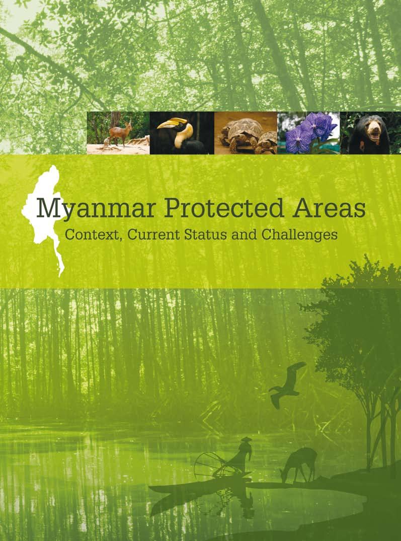
Myanmar Protected Areas. Context, Current Status and Challenges
|
|
|
- Ruby Jacobs
- 5 years ago
- Views:
Transcription
1
2 Context, Current Status and Challenges
3 Forewords In memory of U Uga We, at the European Union, have been fully committed to environmental protection and conservation. Our engagement principles are embedded in the European Union Consensus on Development published in 2005 that outlines our support for biodiversity conservation, water and energy supply as well as the fight against climate change. Environmental protection underpins sustainable development, the more so in a country as Burma/ Myanmar where large parts of the population rely on natural resources for their food, shelter and energy needs. The world s poorest are those directly dependent on natural resources for their daily survival and therefore most vulnerable to environmental hazards. This is why the European Union has made the protection and sustainable management of natural resources a priority in its poverty reduction policies. In Burma/Myanmar, a key instrument for cooperation has been the Non State Actors (NSA) Programme. The overall objective of the NSA programme is to support the emergence of civil society organizations and enable them to fight poverty across a range of sectors such as education, health and livelihoods. The project Strengthening environmental NGOs in Burma/Myanmar implemented jointly by Istituto Oikos and BANCA was the first environment initiative funded by the European Union under this programme. Sound environmental conservation is only effective if based on accurate data and analysis on the state of the environment. This project was a wonderful opportunity to build the knowledge base on biodiversity resources while, at the same time, building capacity for better data collection and analysis. In , the project brokered information exchange among 24 local environmental organisations, and the collection of data in line with internationally approved standards on the natural resources, management, land use, tourism and research in 30 protected areas. Ultimately, BANCA and other local organisations will be better equipped with tools and methodologies to assess biodiversity resources. In addition, we will have a comprehensive database on the state of biodiversity and protected areas across the country. This will allow biodiversity resources to be better understood and we hope it will lead other actors to invest more and better in biodiversity protection and resources conservation. Burma/Myanmar has a unique environment and we must all join forces to ensure that natural resources are sustainably exploited. David Lipman Ambassador Head of Delegation of the European Union to Thailand, Cambodia, Laos and Myanmar III
4 Istituto Oikos believes that biodiversity conservation and equitable natural resources management are crucial to ensure the livelihood of local people, where land degradation and poverty are strictly connected. The approach is based on the following assumption: a well conserved environment is the only guarantee for socio-economic development, poverty alleviation, food security, health and wellbeing for current and future generations. That is why the core of all Istituto Oikos projects, whether they be technical-scientific assistance, environmental evaluations programs, fauna monitoring or support for youth or women s cooperatives, is the relationship between man and nature. Many actions focus on protected areas and on natural areas risking deterioration due to irrational and unplanned use of natural resources. Moreover, the projects never leave aside the awareness-raising factor, so that those involved can understand and share Istituto Oikos objectives, as well as the training of local personnel to ensure the sustainability of work. After 15 years of field activities and more than 150 projects implemented, in Italy and abroad, on biodiversity conservation and sustainable development, Istituto Oikos has gained a wealth of experience in the definition and implementation of methodologies and strategies aimed at integrating the environmental dimension into the socio-economic processes. To reach concrete and sustainable results, as well as to ensure the highest standards of quality in its activities, Istituto Oikos has established firm collaboration with local and national governments, universities, research institutes, conservation, development organisations and business companies, both in Italy and worldwide. Istituto Oikos has been operating in Myanmar since 2006 in order to improve the conservation of natural resources and the capacity building of local NGOs as a tool of sustainable development. Myanmar is a country where natural resources are still well conserved, biodiversity is high and forests cover almost half of the territory. The protected areas of Myanmar conserve spectacular natural, cultural and spiritual values and provide communities with opportunities for recreation and education. As natural areas are progressively being destroyed under different types of human pressure, it becomes increasingly urgent to maintain and improve the condition and management of protected areas. The PA system of Myanmar is essential to continue providing environmental services at community and national level, to prevent climate change and the loss of biodiversity. The protection of cultural values is another important role of the PA system that contributes to spiritual life and Myanmar s historical traditions. Understanding the values within the PA system and evaluating the outcome of management is essential to being able to adapt and improve management practices. In the period , Istituto Oikos and BANCA, with the support of the European Union, the Lombardy Region and Stiftung Drittens Millenium, have managed the project Strengthening environmental NGOs in Burma/Myanmar aimed at improving the capacity of local NGOs to engage in biodiversity conservation and sustainable development programs and coordinate sustainable environmental development investments and activities. The publication : Context, Current Status and Challenges, one of the outputs of the project, presents information on the status of the protected areas in Myanmar. We hope it will help to promote cost-effective initiatives and innovative approaches, to provide technical inputs for policy review processes and to mobilise international awareness and financial support to conserve the unique heritage of Myanmar s protected areas. Rossella Rossi President Istituto Oikos Among South-East Asian countries there is no doubt that Myanmar is the most biologically diverse country on the mainland. It possess a long coastal line of 2,000 kilometers, over 800 islands, mangroves, high mountains of the Eastern Himalayas in the north, a dry zone in the center, Sundaic forest in the south and many types of habitats and ecosystems. There are only few types of habitats left on earth that cannot be found in Myanmar. It still has a high percentage of natural forest cover which is home to a rich diversity of flora and fauna. It is also one of the least explored countries in the world. There have been expressions like after walking two days we found nothing but primeval forest, we barely see a person coming along during our exploration and there is one new bird found in every step we took from nature lovers and bird watchers who have visited Myanmar. The Leaf deer Muntiacus putaonensis and the Myanmar Snub-nosed Monkey Rhinopithecus strykeri are some of the new discoveries within recent years in the Northern part of Myanmar. Other species of reptiles and amphibians new to science have also been reported. The Ministry of Forestry has been trying to protect representative type of forests and up till now has gazetted, nominated and proposed 43 protected areas which cover 7.3 % of total land. But as a developing nation, Myanmar has financial as well as environmental issues. Unfortunately conserving biodiversity and environment is not the top priority of the government. Out of 43 protected area systems only a few have been properly gazetted and have a management system in place. Some are nominated and some are only in a proposal stage. Very few of the gazetted protected areas have full management resources and staff. Even big national parks are short of resources. For them top priorities like regular biodiversity surveys and patrolling are beyond their capacity. As a result very few parks have a comprehensive checklist of flora and fauna. Lampi Island Marine National Park falls in the category that does not have a proper management system and a checklist of flora and fauna that exist in the park. We BANCA and Oikos do sincerely feel honored to conduct this much needed survey which we hope will help the forest department to form a proper management system and serve as a baseline for further evaluation and monitoring of this park. Moreover, we also hope that this publication will serve as a good reference for all existing parks of Myanmar. During recent years people have changed. Their new lifestyle has become more advanced and sophisticated. New changes need new solutions. Population has also increased dramatically and consequently more space becomes essential for their livelihoods and sustainability. The more space they need the more destruction was made to nature and the environment. The lifestyle of people and the changes in the environment have become more interconnected. Issues have become too big and complicated to be handled by a single department or organization alone. Therefore people in the conservation field also have to change. All stakeholders including governments, private and public sectors have to work together to have successful conservation programs. BANCA and Istituto Oikos as stakeholders look forward to assist Myanmar within our capacity especially in the field of biodiversity for successful conservations programs. BANCA appreciates the support of international organizations and the European Union to meet the conservation challenge. Dr Htin Hla Chairman BANCA IV V
5 Acknowledgments Contents A. Bonetti The authors of this publication are researchers affiliated with Istituto Oikos and BANCA. Chapter 1 Context was written by Lara Beffasti (Project Manager, Istituto Oikos) and Valeria Galanti (Biologist, Istituto Oikos). Chapter 2 Protected Areas is co-authored by Lara Beffasti, Valeria Galanti and Tint Tun (Project Manager, BANCA). The maps were produced by Simone Bianchi (GIS expert, Istituto Oikos), Mi Mi Choe (GIS expert, Forest Department) and Thein Ko (GIS expert, BANCA) thanks to data provided by Forest Department and Wildlife Conservation Society, and data collected in the field. Photographs are by project staff in Myanmar during project period Chapter 3 In-depth study of Lampi Island Marine National Park was written by Lara Beffasti and Valeria Galanti, also based on the reports of the field surveys undertaken between 2008 and 2010 by researchers affiliated to MEP and MABR projects listed in Table 15. Photos of the Myeik archipelago have been made available by Andrea Bonetti ( Chapter 4 In-depth study of Rakhine state is co-authored by Simone Bianchi and Roberto Colombo (Researcher, Università Milano Bicocca). Chapter 5 Conclusions and Recommendations was written by Lara Beffasti and Valeria Galanti, also including the results of the stakeholder workshop held in Yangon in March Serena Arduino reviewed the draft text and provided valuable corrections and suggestions. Useful revisions and translations to and from Myanmar language were ably made by Tint Tun and Htoo Htoo. English language editorial support was provided by Guy Waley. The authors wish to express their gratitude for the valuable inputs and involvement to all Istituto Oikos, BANCA and Forest Department staff and others who have made various contributions to the implementation of project activities or in the preparation of this publication and in particular to (in alphabetical order) U Aung Than, U Aye Myint Maung, U Bo Ni, Daw Dewi Thant San, Alessandra Gagliardi, Paola Mariani, Dr. Maung Maung Kyi, Dr. Maung Maung Than,U Maung Maung Thein Pe, U Myint Sein, Daw San San Nwe, Francesca Santapaola, Dr. San Win, U Saw Han, Dr. Saw Mon Theint, U Ohn, U Saw Tun Khaing, U Shein Gai Lai, Sara Stingelin, Daw Thandar Win, U Than Latt Shein, Daw Than Than Aye, U Tin Tun, U Tint Wai, Guido Tosi, Brunella Visaggi, U Win Maung and U Win Naing Thaw. We especially acknowledge U Uga, former Chairman of BANCA, who passed away in April 2010, and without whom this project would have not been possible. We warmly acknowledge Delphine Brissonneau, Programme Officer of the European Union Delegation, and Rossella Rossi, President of Istituto Oikos, who went beyond the call of duty in the support to the programme in Myanmar. Istituto Oikos is grateful to Luca Schueli for the invaluable introduction to Myanmar. All project team wish to thank the participants in all of the meetings, discussions and interviews organized by this project villagers, scientists, foresters, protected area managers, NGO workers and executives alike who shared the willingness to make a positive contribution to the conservation of Myanmar natural resources Forewords III Acknowledgements VI Acronyms used in the text VIII Introduction IX Executive Summary X Executive Summary (Myanmar language) XII Background on Myanmar 1 Natural Features 1 Environmental Policy and Practice 4 Environmental Non-governmental Organizations (ENGOs) 8 11 Methodology 11 Results 14 Alaungdaw Kathapa 22 Bawditataung 24 Bumhpabum 26 Chatthin 28 Hlawga 30 Hponkanrazi 32 Htamanthi 33 Hukaung Valley 34 Hukaung Valley (Extension) 34 Indawgyi Lake 36 Inlay Lake 38 Kahilu 40 Kelatha 42 Khakaborazi 44 Kyaikhtiyoe 46 Kyauk-Pan-Taung 48 Lampi Island 50 Lawkananda 52 Lenya 54 Lenya (Extension)* 54 Loimwe 56 Maharmyaing 58 Mainmahla Kyun 60 Minsontaung 62 Minwuntaung 64 Moscos Island 66 Moyingyi Wetland 68 Mulayit 70 Natma Taung 72 Panlaung-Pyadalin Cave 74 Par Sar 76 Pidaung 78 Popa 80 Pyin-O-Lwin 82 Rakhine Yoma Elephant Range 84 Shinpinkyetthauk 86 Shwesettaw 88 Shwe-U-Daung 90 Tanintharyi National Park Tanintharyi Nature Reserve 94 Taunggyi 96 Thamihla Kyun 98 Wenthtikan 99 In-depth Study of Lampi Island Marine National Park 101 Purpose 101 Results 101 Conclusions and recommendations 118 Box 1 Plain-pouched Hornbill 119 Box 2 Moken Sea Gypsies Checklist of Lampi MNP resources 122 In-depth Study of Rakhine Yoma Elephant Range Wildlife Reserve 133 Data and methods 135 Results 139 Conclusions and recommendations 144 Conclusion 145 Progress and priorities for Myanmar PAs 146 Recommendations 146 References 148 Appendices 150 VI
6 Acronyms used in the text Introduction ASEAN BANCA BLI CAS CBD CITES DOF EIA EBA ENGO FAO FD FRA GEF IBA IUCN KBA MFA MOF MPA MoU NCEA NFMP NGO NSDS NWCD PA PFE SEAFDEC SI UNDP UNEP WCPA WCS WR WS Association of South East Asian Nations Biodiversity And Nature Conservation Association BirdLife International California Academy of Science Convention on Biological Diversity Convention on International Trade in Endangered Species of Wild Fauna and Flora Department of Fisheries Environmental Impact Assessment Endemic Bird Area Environmental Non-governmental Organisation Food and Agricultural Organization Forest Department Forest Resource Assessment Global Environment Facility Important Bird Area International Union for Conservation of Nature Key Biodiversity Area Ministry of Foreign Affairs Ministry Of Forestry Marine Protected Area Memorandum of Understanding National Commission for Environmental Affairs National Forest Master Plan Non-governmental Organization National Sustainable Development Strategy Nature and Wildlife Conservation Division Protected Area Permanent Forest Estate Southeast Asian Fisheries Development Center Smithsonian Institution United Nations Development Programme United Nations Environment Programme World Commission on Protected Areas Wildlife Conservation Society Wildlife Reserve Wildlife Sanctuary Protected areas (PAs) are important tools for biodiversity conservation and sustainable development. PAs safeguard ecosystems and their services, such as water provision, food production, carbon sequestration and climate regulation, thus improving people s livelihoods. They preserve the integrity of spiritual and cultural values placed by indigenous people on wild areas and offer opportunities of inspiration, study and recreation. Due to a long period of isolation, Myanmar has conserved an extraordinary natural and cultural heritage that is in part represented in its protected area system. The expansion of agriculture and industry, pollution, population growth, along with uncontrolled use and extraction of resources, are causing severe environmental and ecosystem degradation. Loss of biodiversity is the most pressing environmental problem because species extinction is irreversible. Realising the urgency of Myanmar environmental challenges, several stakeholders, at national, international and regional level, have committed to support conservation and management of PAs. However, baseline information on natural resources, threats, management, staff, infrastructure, land use, tourism and research in Myanmar PAs was hardly ever updated and not systematically organised, thus limiting the subsequent planning and management of resources. Therefore, the aim of this publication is twofold: to raise awareness on the condition of the conservation of PAs and to mobilise national and international support for cost-effective initiatives, innovative approaches and targeted research in priority sites. The document provides background information on Myanmar natural features, environmental, government and non-government frameworks (Chapter 1). The core section makes available the information retrieved in the period on the status of Myanmar PAs (Chapter 2) and the results of the research conducted in Lampi Island Marine National Park (Chapter 3) and Rakhine Yoma Elephant Range Wildlife Reserve (Chapter 4). Data collection, analysis and organisation were part of the larger Myanmar Environmental Project (MEP) managed by Istituto Oikos in partnership with BANCA. Conclusion and recommendations for the management of Myanmar PAs (Chapter 5) were jointly formulated by stakeholders during the MEP closing workshop held on March 17th 2011 in Yangon. The information presented in this publication is also organised in a database available to stakeholders that will be updated with new data provided by PA managers, academic institutions, environmental organisations and community-based groups working in Myanmar PAs to fill the existing gaps. VIII IX
7 Executive summary This publication presents the information collected on Myanmar protected areas (PAs), with the objective of mobilising national and international support for cost-effective initiatives, innovative approaches and targeted research implemented by non- State actors in collaboration with authorities and communities in sites needing priority conservation actions. Myanmar presents a great variety of habitats and ecosystems, from snow-capped mountains to coral reefs, supporting a rich biodiversity. Demographic and socio-economic pressures have been identified as the main causes of environmental degradation and biodiversity loss. The environmental protection framework set up by Myanmar during the 1990s shows legal and institutional constraints. Environmental laws are very sector-specific and institutions lack capacity and resources for their implementation. Nonetheless, progress has been made towards the integration of environmental issues in the national development process and stakeholders consultation mechanisms have increased coordination in planning. A small but growing number of Myanmar environmental NGOs has emerged and is playing an important role to facilitate environmental education, research work and co-management of resources at local level. In Myanmar there are currently 43 officially-recognised PAs but so far the information on their status has been poor, scattered and not updated. A comprehensive datasheet was prepared to organize in a systematic way the information collected on natural resources, management, staff and infrastructure, tourism, land use and human activities and research, following internationally approved criteria and standards. Existing information was first retrieved from authorities, organisations and academic institutions; then it was verified and integrated through field visits and meetings with stakeholders for 30 PAs while maps were produced for all 43 PAs. All information is organised in a database available to stakeholders. Myanmar PA system currently covers 7.3 % of the country. Despite the long coastline there are only 4 marine protected areas and there is little capacity to conserve and manage marine resources. The number and size of PAs have increased over the years but also some terrestrial habitat types are still underrepresented, in particular beach and dune, mangrove and swamp forests. Human encroachment in PAs is common and requires intervention to limit it, however in most cases the conservation status is considered to be within an acceptable range of variation. Only half of the PAs have partial biodiversity inventories and an operational or management plan including actions that are regularly implemented despite inadequate human, technical and financial resources. Seventeen PAs are only paper parks. Religious tourism and ecotourism exist in many PAs but most lack the resources and skills to invest in effective tourism management and consequently forego the opportunity to generate revenues from it. Scientific research has been conducted in 28 PAs by national and international organisations and universities without a coordinated research programme. Two PAs were selected for in-depth studies: Lampi Island Marine National Park and Rakhine Yoma Elephant Range Wildlife Reserve. Lampi Island Marine National Park (MNP) is the only MNP in Myanmar and the only protected area of the Myeik archipelago. Very little information was available on this area and it had not been updated since Collecting data on this area was considered very important to raise the awareness of Myanmar and international stakeholders on the importance of conserving the archipelago and involving the local heterogeneous population composed by indigenous minorities and migrants from different areas of Myanmar in participatory resources management. The rapid L.Beffasti assessment survey conducted in January 2009 confirmed the great value of the archipelago in terms of biological and cultural attributes, threatened by the uncontrolled and rapid increase of human settlements and activities. Field surveys identified 195 species of plants of the evergreen forest, 63 mangroves and associates, 19 mammals, 228 birds, 19 reptiles, 10 amphibians. Among the marine resources, 333 plankton species, 73 seaweeds, 11 seagrass, 50 gastropods, 42 crabs, 41 bivalves, 35 sea cucumbers and 42 fish species. 29 species are new records for Myanmar (1 phytoplankton, 7 zooplanktons, 2 seagrasses, 1 mangrove tree, 7 fishes, 3 amphibians, 8 birds). Furthermore, the issues of the Salone (or Moken) people were collected, as well as those of other human settlements in the area. As population grows inside and outside the park, the natural resources are increasingly threatened by unsustainable use. Consultations among authorities, organisations and communities were initiated to launch the participatory development of a management plan for the MNP to ensure the incorporation of the needs and aspirations of local communities along with conservations goals. The Rakhine Yoma Elephant Range Wildlife Reserve encompasses a great variety of habitats supporting high biodiversity and many endemic and endangered species, but it is one of the most encroached PAs. Local communities are dependent on natural resources for their livelihoods and are often damaging the environment and using its resources without due regard to sustainability. A GIS database was set up to propose a preliminary classification of vegetation types, which was then verified through a ground-truthing campaign. Ten vegetation classes were identified and land cover maps produced. The vegetation change between 1974 and 2003 was analysed showing the conversion of natural forests to agricultural areas and vice-versa. The main finding is the invasion of Melocanna bambusoides in the area, probably subsequent to forest fires and shifting cultivation practices; creation of a buffer zone and implementation of environmental education and sustainable development activities are crucial to prevent the degradation of the last patches of forest. New data and maps on vegetation change and land use can thus support sustainable development plans and activities, and raise awareness on the current threats to this ecosystem. According to project findings, Myanmar PA system should be reviewed giving emphasis to the management objective and strategically expanded to address gaps in coverage of globally threatened species, underrepresented mangrove and marine habitats, Key Biodiversity Areas and wildlife corridors. It is crucial to improve coordination between Forest Department (FD) and other departments and it is also advisable to pilot joint governance initiatives at local level in collaboration with NGOs and communities. While public awareness needs to be raised, from top to grass root level, on the role and benefits of protected areas in order to achieve comprehensive stakeholder participation in conservation, FD staff, especially young generations, should receive intensive training in ecology and management. This would enable the preparation of a management plan and a biodiversity inventory for every PA to be organised in a central database to facilitate coordination and information sharing at national and international level, also to develop coordinated research programmes. The human impacts of PAs should be measured in order to identify and implement innovative poverty reduction strategies that can contribute to meet the conservation and development goals. To ensure the allocation of adequate resources, sustainable financing mechanisms should be identified, including grants and donations and local business development. X XI

")
8 Executive summary (Myanmar language) XII XIII

 of mainland covered by forests (FAO 2010), Myanmar ranks 6 out of 11 among the Southeast Asian countries in terms of percentage of land area covered by forest (FAO 2009).")
9 1 Background on Myanmar 1.1 Natural Features Introduction Myanmar, the largest country in South East Asia, is part of the Sundaic subregion of the Indo-Malayan Realm (MacKinnon and MacKinnon 1986). Due to the combination and interaction of geography, topography, climate, pattern of seasonal rainfall, presence of high mountains and major rivers, Myanmar presents a great variety of different habitats and ecosystems supporting a rich biodiversity. With about half (48%) of mainland covered by forests (FAO 2010), Myanmar ranks 6 out of 11 among the Southeast Asian countries in terms of percentage of land area covered by forest (FAO 2009). Figure 1 Myanmar Land Area (Source: NCEA 2009b) Forest 48% Other land 16% Other wooded lands 33% Inland water bodies 3% Northern Myanmar presents the highest mountains with permanent snow and glaciers, with Mount Khakaborazi (6,000 m) being the highest in Myanmar and in South East Asia. The country includes extensive lowland plains, major rivers running parallel to each other, one of the largest river deltas in Asia (Ayeyawaddy Delta) and plateau around 1,000 m above sea level like the Shan Plateau. Myanmar, with its 2,280 km long coast and more than 800 small islands, has important coast and marine habitats supporting an abundance of species. The climate is a tropical monsoon climate with three distinctive seasons: hot season from March to May, rainy season from June to October, cold season from November to February, with high rainfall variability, from 500 mm in the Dry Zone up to over 6,000 mm in Tanintharyi Region and northern Rakhine State. Biodiversity About 250 mammal species, more than 1,000 birds, 370 reptiles and 7,000 plants are recorded in Myanmar, including 39 species of mammals, 45 of birds, 21 of reptiles and 38 of plants which are globally threatened (NCEA, 2009a). More species could be added since new discoveries continue to be made every year, including the exceptional discovery, during a survey of FFI and BANCA in Kachin state, of a new species of primate in 2010, the Burmese snub-nosed monkey Rhinopithecus strykeri, immediately classified as critically endangered by IUCN. 76 Key Biodiversity Areas (KBAs) have been identified, out of which 54 are recognized as Important Birds Areas (IBAs) (BLI 2005). Endemism is relatively low compared to other countries in South East Asia. There are seven Endemic Birds Areas EBAs and secondary endemic areas (BLI 2005 and IUCN-WCPA 2007), three exclusively located in Myanmar (Eastern Himalayas, Irrawaddy plains and North Myanmar Lowlands), two stretching across Myanmar and Thailand (Myanmar-Thailand mountains and Peninsular Thailand lowland forests) and two others centered mainly in other countries but extending in Myanmar (Andaman Islands and Yunnan mountains). Natma Taung National Park is a particular area of local endemism. XIV 1 L. Beffasti
10 Background on Myanmar Habitats Important habitat types represented in Myanmar are forests, wetlands and the marine habitat. Eight different forest types are found in Myanmar: tropical evergreen forest, mixed deciduous forest, dry forest, deciduous dipterocarp forest, hill and temperate evergreen forest, tidal forest or mangrove forest, beach and dune forest, swamp forest (Tint, 1995). Figure 2 Forest Types of Myanmar (Source: NCEA 2009b) 38% Mixed Deciduous Forest 25% Hill and Temperate Evergreen Forest 16% Tropical Evergreen Forest 10% Dry Forest 5% Deciduous Dipterocarp (Indaing) Forest 4% Tidal Forest, Beach and Dune Forest, Swamp Forest 2% Fallow Land The tropical evergreen forest is mainly represented in Myanmar by the lowland wet evergreen forest, a lush vegetation forest dominated by high value commercial species like the evergreen Dipterocarpus species. This forest is found quite well conserved along the coast of the Tanintharyi Region. The mixed deciduous forest is the major forest type of Myanmar and is characterized by the high-value timber species of Tectona grandis, commonly known as teak, often found in association with Xylia dolabriformis and different species of Terminalia. The presence of Tectona grandis makes this forest also the most economically important forest of the country. The mixed deciduous forest is strictly associated with bamboo species, which represent an important source of food for many wildlife species, and supports endangered species like the Hoolock Gibbon. The dry forest, represented by thorn scrub and forest, it is found in the Central Dry Zone, characterized by dry and seasonal climate, where the rainfall is usually under 1,000 mm. The dominant species are Terminalia oliveri and Tectona hamiltoniana, with a number of thorny Acacia species. The deciduous dipterocarp forest is found only in five countries in the world, namely Myanmar, Laos, Cambodia, Vietnam and Thailand. Also known as Indaing forest in Myanmar, is commonly found at higher altitudes in the northern part of the country. It is characterized by open canopy of deciduous species of Dipterocarpaceae. This forest type has remained isolated from other similar forests of South East Asia, making it one of the centres of endemism in Myanmar. It hosts endemic species like the critically endangered Burmese Star Tortoise and many threatened species like the vulnerable Eld s Deer. The hill and temperate evergreen forest is found in high rainfall areas, on slopes between 900 m and 1,800 m (hill forests) and over 1,800 m (montane forest). Dominated by tree species of Quercus, Castanopsis, Schima, Fagaceae, Magnoliaceae, Lauraceae and Ericaceae, this forest type is characterized by many climber species and rich and lush undergrowth. Beyond the coniferous forests, sub-alpine forest and L. Beffasti alpine meadows are found at the highest elevations on the mountains, before the level of permanent snow and ice. Mangrove forests (or tidal forests), found along alluvial flats of river deltas and on muddy coastal areas, are salt tolerant and are flooded by seawater during high tide. This type of forest has a very important ecological function since it stabilises the shoreline, protects the coast from erosion and is a particularly important habitat for migratory waterbirds. Mangroves offer a variety of forest and aquatic products to many coastal people and largely support fish production. Myanmar hosts 8.8% of the total mangrove forests area of South East Asia, being the third richest country after Indonesia and Malaysia. Of the total mangroves area in Myanmar, 46% is located in Ayeyawaddy Region, 37% in the Tanintharyi Region and 17% in the Rakhine State (Giesen et al. 2006). They are all considered under threat, although many areas are nominally protected. Beach and dune forest represents a minority of total forest area in Myanmar, and it is found in narrow strips on beaches and dunes along the coasts, usually dominated by Casuarina equisetifolia. The swamp forest, found in the Ayeyawaddy Delta and in the floodplains of other rivers and lakes, and wetlands are of high ecological importance for many bird species which have suffered dramatic population declines across their global distributions. Many of these wetland sites have been recognized as Important Bird Areas and some proposed as Ramsar sites. The marine habitat, supporting a high biomass of fish and other aquatic organism, represents an important source of income for the country, with the fishery sector as the fourth largest sector in Myanmar, and shrimp export accounting for nearly 50% of the total value of fishery export. Coral reefs are extensive on the south east coast of Myanmar (fringing reefs and patch) and around the islands, extending further south into Thailand, covering 1,870 km², with the majority of coral reefs found in the Myeik Archipelago of the Tanintharyi Region. Coral reefs in Myanmar need to be more fully surveyed and better protected since they provide many functions, services and goods in terms of coastal protection and sediment retention, nurseries and habitats for aquatic organism, feeding grounds for economically important species of fish and other seafood products, potential revenues from tourism. Seagrasses are mainly found in Rakhine and Tanintharyi marine areas, while they are absent in the Ayeyawaddy Delta because of high turbidity. Seagrass beds represent a food source and shelter habitat for many economically important species of marine invertebrates and fishes, and globally threatened species like the Dugong (Dugong dugon). Seagrass habitat has an important role in stabilizing the coast, reducing waves and the effects of currents and trapping the sediments, thus protecting coral reefs from sedimentation. 2 3
 for development projects.")
11 Background on Myanmar Environmental problems In 2001, a report of the Myanmar Ministry of Forestry identified the following major threats to forest and biodiversity: conversion of closed forests to other land uses, shifting cultivation, invasive species, illegal fishing and water pollution, wildlife and timber trade, lack of environmental impact assessment (EIA) for development projects. The 4th National Report on Biodiversity (2009) confirms that Myanmar is losing biodiversity due to socio-economic pressure, with the main threats identified in habitat destruction, especially related to forest depletion, degradation and cover change, hunting and illegal wildlife trade. Invasive alien species are considered a minor threat. The net loss of 435,000 hectares of forest per year reported for the period , corresponding to a loss of 1.17%, was reduced to 310,000 hectares per year in the period , corresponding to a loss of 0.93%. Despite this positive trend, Myanmar still remains one of the ten countries in the world with the largest annual net loss of forest area and among the five countries (Indonesia, Australia, Myanmar, Madagascar and Mozambique) with the largest net loss of mangrove area during the period (FAO 2010). In the Ayeyawaddy Region, mangrove forest has been seriously degraded in recent years due to agricultural conversion and the high demand for firewood and charcoal from Yangon, with consequent decline of fish catches and increased vulnerability to natural disasters. In Tanintharyi Region the best conserved mangrove forests are found, especially in the Myeik Archipelago, but still a decrease of 2.4 % per annum is estimated (U Myint Pe 2003). In Rahkine, shrimp farming, representing 89% of all the shrimp farming in the country, has seriously contributed to mangrove depletion and prevented reforestation in many areas. Since shrimp farming is still encouraged without any proper planning, mangrove forests are expected to continue to decrease (Angell 2004). Agricultural expansion, shifting cultivation, conversion of forest to plantations are the main causes of habitat degradation and loss. Rubber plantations have almost doubled from 1990 to 2010 (FAO 2010) and together with large scale palm oil plantations are among the most impacting threats on biodiversity. Although accurate updated estimates are difficult to obtain, illegal wildlife trade in Myanmar is considered to be widespread, causing, with illegal hunting, a general decrease of wildlife population. Colonial period ( ) After an initial phase of uncontrolled overharvesting of forest resources, the colonial government gradually shifted to the systematic management of forests (Bryant 1994). The first Forest Rules (1856), later adopted for the whole Indian province (1865), promoted the adoption of a scientific forestry method set up by the German forester Dietrich Brandis including the adoption of 30-year felling cycles and the prescription of exploitable tree sizes to fix the annual sustainable yield. Brandis guidelines were integrated into the Indian Forest Policy (1894) and Burma Forest Act (1902) and reviewed into the Myanmar Selection System for forest management in use since 1920, marking the government ownership of teak forests. Reserved forests and protected forests were created, whereas government timber-extraction was allowed, thereby restricting only resource access and use by local people. Shifting cultivation (taungya) practices, forest fires for hunting and non-timber forest products extraction were prohibited but difficult to control. To gain popular support for reserved forests, the government promoted the participation of local peasants, in particular Karen hill farmers, in forestry activities by encouraging them to sow teak trees in their taungya fields in exchange for tax exemption, paid labour and land, and thereby creating new plantations. The concern for wildlife conservation aroused only at the beginning of 20th century with the creation of the first wildlife sanctuary of Pidaung for the protection of Sumatran rhinoceros. At the end of the colonial period (1948), the protected areas system included 11 bird and wildlife sanctuaries 1 covering less than 0.3% of total country area. Development of Myanmar environmental governance and legislation In the first thirty years following independence ( ), little attention was paid to environmental protection because the country was facing economic and political struggles. In the 1980s the Forest Department initiated, in collaboration with UNDP and FAO, the Nature Conservation and National Parks project ( ) for the expansion of the protected area system 2 and the establishment of a new institution with specific competence on conservation and PA management. In the 1990s the legal and institutional framework of environmental governance was completely reviewed and updated resulting in the creation of new institutions and the formulation of new policies for forest and protected areas management (a list of environmental laws and policies is given in Appendix 1). Table 1: Chronology of Environmental Governance in Myanmar L.Beffasti 1.2 Environmental Policy and Practice Introduction After a period of intense exploitation of natural resources during the colonial and post-colonial period, Myanmar leaders showed their commitment to conserving the environment and promoting sustainable development with the creation in 1990 of ad hoc institutions in charge of preparing new environmental policies and legislation, of strengthening international cooperation on environmental issues and of improving the management of natural resources. However, the current environmental protection framework shows critical legal and institutional constraints, for instance very sector-specific laws that often exceed the technical and financial capability of the relevant government agencies. The future success of environmental protection in Myanmar depends on the formulation of policies reflecting a more integrated approach to planning and management of resources, as well as on the improved coordination between stakeholders and the allocation of the necessary resources for policy implementation Creation of the National Commission for Environmental Affairs (NCEA) within the Ministry of Foreign Affairs (MFA) with competence on environmental policy and management with the objective of promoting environmental awareness, sustainable use of natural resources and collaboration with international organisations and foreign governments on environmental matters. Creation of the Nature and Wildlife Conservation Division (NWCD 3 ) within the Forest Department to supervise protected areas and wildlife conservation. Creation of the Ministry of Forestry constituted by four entities: 1) Forest Department (FD) which is responsible for conservation and sustainable management of forest, 2) Myanmar Timber Enterprise (MTE) in charge of commercial forest activities, 3) Dry Zone Greening Department coordinating reforestation activities in central Myanmar, 4) Planning and Statistics Department in charge of overall supervision. 1 Chatthin, Kahilu, Kelatha, Moscos Islands, Mulayit, Pidaung, Pyin-O-Lwin, Shwesettaw, Shwe-U-Daung, Taunggyi, Wenthtikan designated protected areas (Htamanti, Minwuntaung and Thamila Kyun were established in the 1970s) for a total area of 4150 km², representing 0,6% of total country area. 3 The original name was Nature Conservation and National Parks Division (NCNPD). 4 5

12 Background on Myanmar % cover of total country area The Ministry of Forestry (MOF) gradually took over the coordination of environmental protection in Myanmar, especially after the nomination of the Minister of Forestry as chairman of the Environmental Conservation Committee in 2004 and the transfer of NCEA from MFA to MOF in As a consequence, the environmental policies and laws are very sectoral and focused on forest management and nature conservation instead of considering environmental issues as cross-cutting within the economic and social development of the country. Furthermore, MOF inherited the extractive mentality of the colonial government and its first priority remains the commercial exploitation of forests. NWCD and NCEA are the lowest institutions in the internal hierarchy of MOF, thus they have little capacity, opportunity and resources to mainstream environmental protection at national level. Nevertheless, both agencies have collaborated in the formulation of the Forest Law (1992) which regulates forest protection and management, establishment of forest plantations, extraction of forest products, as well as administrative action towards offences, replacing the old Burma Forest Act (1902). The importance given to public participation in forest management as well as to private sector involvement is highlighted in the Forest Rules and Community Forestry Instructions issued in 1995 to fulfill this law. In the same year the national Forest Policy was promulgated with the assistance of FAO, aiming for a more integrated approach towards environmental protection. The Forest Policy (1995) recognises different categories of forest: i) reserve (reserved) forests which are fully protected for commercial and local supply, watershed protection and biodiversity conservation, ii) public protected forests protecting trees but allowing other activities, iii) unclass (unclassified) forests where access is open to local people. The protected area system falls under the Protection of Wildlife and Wild Plants and Conservation of Natural Areas Law (1994), which replaced the old Wildlife Protection Act (1936). This law regulates the establishment of six categories of PAs (scientific nature reserve, national park, marine national park, nature reserve, wildlife sanctuary, geo-physically significant reserve) and of other nature reserves determined by the Minister of Forestry, which can be compared to international categories as further explained in chapter 2. In 2001 a 30-year Forest Master Plan was approved mandating the increase of the Permanent Forest Estate PFE (constituted by reserved forests and public protected forests) to 30% and of PAs to 10% of the total country area. These targets reinforced and replaced those set by the Forest Policy (1995), respectively the increase of PFE to 30% and PA system to 5% of the total land area by Furthermore, the Forest Master Plan encourages the registration of unclassified forests into community or private forests. Data collected from combined sources 4 show that although in the decade the forest cover of Myanmar has decreased, the area protected or managed under PFE, PA or community/private forestry has increased, which is indicative of the effort to prevent the conversion of unprotected forest areas to other land uses (see Figure 3). Figure 3 Trend of Forest and Protected Area 4 60% 50% 40% 30% 20% 10% 0% forest cover Reserve forests and Public protected forests Protected Areas Community and private forests Status Status 2004 Status 2009 Status 2030 Since the 1990s Myanmar has also increased the participation in the international fora regarding environmental matters which resulted in the signing of several international environmental agreements which are given in Appendix 2. L. Beffasti Policy implementation As for any other government policy, the effectiveness of environmental policies depends mostly on the political will and the availability of resources to implement it. Biodiversity conservation is hardly being given the first priority, especially in developing countries where it is generally perceived as a constraint to economic development. Furthermore, the legal and institutional constraints described above have an impact on the execution and enforcement of such policies. On one hand, the sectorspecific policies leave gray areas (e.g. no procedures or rules for Environmental Impact Assessments) or produce overlapping (e.g. marine national parks fall under both Ministry of Forestry as protected areas and Ministry of Livestock and Fisheries for the conservation of marine resources). The lack of coordination is not only between different ministries or departments but also between centre and peripheries. Although Myanmar state is highly centralised and most decisions are taken from centre, localities have ways of blocking and influencing decisions, for instance through slow and inaccurate information flow. Alongside the legal and institutional framework, it is important to consider the attitudes of the individuals towards conservation. The conservation and management of PAs rest with forest officers who are specifically trained in planning and implementing forestry operations. Most forest officers are not acknowledgeable of the ecological functions of ecosystems and recognize only a few tree species as valuable. Thus their professional judgment, summed up with the lack of incentives (low salaries and no travel allowance) and the low perceived control from the centre, reinforces the general attitude of neglecting PAs. However, many of NWCD staff are very dedicated to conservation, especially those who have received training abroad or from international agencies, and play a remarkable role 4 Data for the period are from FAO, Asia and the Pacific National Forestry Programmes: Update 34, December Data for 2004 are from Forest Research Institute, Status of forest genetic resources, their conservation and management in Myanmar, Presentation by Aung Zoe Moe Data for 2009 are from NCEA, Sustainable Forest Management: Perspectives on REDD development, Presentation by Htwe Nyo Nyo One example is the famous Buddhist monk Maing Fone of Par Sar, thanks to whom the protected area has been established and conserved so far without the allocation of staff and resources by FD. 6 In 2010 the Forest Department reported international cooperation with the following organisations: Asian Wetland Census (AWC), Birdlife International (BLI), California Academy of Science (CAS), Global Tiger Forum (GTF), International Crane Foundation (ICF), Istituto Oikos, Makino Botanical Garden (MBK), Smithsonian Institute (SI), Wild Bird Society of Japan (WBSJ), Wildlife Conservation Society (WCS), World Conservation Union (IUCN), World Pheasant Association (WPA). Other organizations are working in Myanmar without official recognition. 6 7
.")
13 Background on Myanmar in the protection of the areas where they are assigned. Other actors seem to have a positive influence on the effectiveness of conservation policies, for instance religious figures 5 and non-governmental organizations (NGOs). In particular, the cooperation with international organisations 6, albeit limited by the economic sanctions and the complicated bureaucratical procedures that apply to foreign subjects in Myanmar, has supported research surveys that have resulted in the discovery of new species and the establishment of new PAs, and has provided funding and training for the management of PAs, including development actions to encourage grassroots support for conservation. International cooperation is also contributing to strengthen the civil society of Myanmar by building the capacity of national and local organizations to plan and manage conservation and development initiatives. Recent developments and future trends In 2009 NCEA published the National Sustainable Development Strategy (NSDS) for Myanmar which has been formulated in collaboration with UNEP through the combination of consultative forums and multi-stakeholders mechanisms. This represents an important step towards the improved coordination between relevant stakeholders and the integration of environmental considerations into development. Nevertheless, as of 2010 the members of the National Council for Sustainable Development, who shall be in charge of the implementation of NSDS, still have not been selected, thus deferring the promulgation and enforcement of detailed regulations. Further restructuring of the environmental policies and concerned institutions is expected in 2011, following the election of a new government in November Environmental Non-governmental Organizations (ENGOs) Introduction Myanmar has a small but growing number of NGOs working in the field of biodiversity conservation and sustainable development. Not only the number but also the capacity of ENGOs has increased, with bigger projects in the field and emerging networks of coordination between them. The recent participation of Myanmar ENGOs in stakeholder consultation mechanisms at national level is an indicator of the mounting recognition of their role in the development and implementation of environmental policies, including research work, awareness raising and environmental education. If existing constraints to their operations are overcome, ENGOs can contribute to processes of co-management of resources and sustainable development by coordinating and channeling the opinions, problems and expectations of the most vulnerable groups living in and around key biodiversity areas of Myanmar. Figure 4 Trend of Growth of Myanmar ENGOs (Source: MEP project) No. of ENGOs Year of establishment Overview The number of ENGOs operating in Myanmar is very small compared to neighbouring countries due to the existing restrictions to civil society and the shortage of funding for environmental activities. However, during project duration ( ) 24 organisations working in environment-related sectors have been identified, starting from a baseline data of 10 organisations provided by Local Resource Centre of Yangon in The information collected is also organised in a directory available to stakeholders. Most ENGOs were established by a strong charismatic leader. In particular, the bigger ones have been founded and managed by retired officials of the Forest Department, thus being able to implement their activities with lesser restrictions by township and district authorities. In addition, high-rank forest officers received during their career many opportunities of training and study abroad and collaboration with international agencies. With well-trained executives, direct access to local communities and easier collaboration with authorities, ENGOs seem to be in the best position to implement conservation activities in Myanmar and their potential is recognised by international organisations providing funding. On the other hand, ENGOs mirror to a certain extent some specific features of government departments, for instance very hierarchical management structure with low numbers of women and young people in high positions and weak strategic planning. The internal organisation is generally poor and, although most ENGOs have a management board, one third of them relies only on volunteers. ENGOs coordination was initially based on personal relations among the executives, sharing common education or work patterns, but it has lately become more consistent. The project got underway in March 2010 with the organisation of monthly meetings of the Environmental Working Group within Myanmar NGO Network, chaired in succession by different ENGOs which can hold discussions among themselves in Myanmar language. Parallel to this, the bigger ENGOs have also participated since 2009 in the Environmental Thematic Working Group chaired by UNDP, where government and non-government actors discuss the most pressing Myanmar environmental issues. Table 2 Facts about Myanmar ENGOs (Total number of ENGOs reviewed: 24) Category: Non-governmental organisation 67% Community-based organisation 17% Professional organisation 8% Association 4% Consortium of NGOs 4% Percentage of ENGOs formally registered 50% Percentage of ENGOs with management board 88% Volunteers number: No volunteers 20% >10 15% % Over 50 50% Location of activities: Ayeyawaddy Region 67% Yangon Region 54% Chin State 50% Shan State 42% Kachin State 33% Mon State 21% Rakhine State 21% Tanintharyi Region 17% Mandalay Region 17% Sagaing Region 13% Magwe Region 13% Kayah State 4% Kayin State 4% Bago Region 4% Staff number: No staff 17% >10 25% % Over 50 29% Sectors of activities: Forestry and Agroforestry 50% General Environmental Protection 33% Education 33% Water supply 29% Relief 21% Energy 13% Fisheries 8% Health 4% Banking and Financial Services 4% L. Beffasti 8 9

14 2 Operations and challenges Environmental protection, forestry and public education are the main sectors of activities for Myanmar ENGOs. These are increasingly being integrated with the provision of water, energy and other social services. Some ENGOs also take part in relief operations following natural disasters. Most ENGOs have their main office in Yangon and field offices spread all over Myanmar, except for securityrestricted areas. In particular, most operate in cyclone-affected areas 7 of Yangon and Ayeyawaddy Regions. Only four organisations are based in the ethnic states of Chin, Kachin and Rakhine, where they operate with a strong network of volunteers. In the implementation of their programmes, ENGOs face several constraints. First the funding for environmental activities, especially terrestrial and marine conservation, waste and recycling, climate change, is limited because of the international sanctions 8. At present, funding comes mainly in form of partnership agreements with (or sub-granting by) international organisations. Larger ENGOs have recently been awarded small grants locally from Embassies and other donors based in Yangon. Many ENGOs do not meet the requirements to access either type of funding. Out of 24 organisations, only half are officially recognised by the Myanmar state as non-governmental organisations 9, 2 are registered as professional organisations and the remaining 8 have not yet concluded the registration process. Moreover only registered ENGOs can open a foreign currency bank account at Myanmar Foreign Trade Bank and be exempted from 10% tax that applies to all international transactions. Indeed, the ultimate challenge for ENGOs is to gain the trust of local communities. ENGO workers may be regarded with some suspicion by local people, especially when they are not native to the area or are former forest officers. What is more, ENGOs can work mostly in the least valuable forest areas, waste lands that have become unproductive after few years of intensive exploitation with many difficulties in raising local interest for participation. People start to trust NGOs only when they see that they are not after profiting from forests and that they are bringing solutions for the most pressing issues such as land rights, water and energy supply. However, trust has to be constantly renegotiated by encouraging local participation in planning and implementing sustainable development strategies with immediate effects on poverty reduction. 2.1 Methodology In 2009 Forest Department provided a list of 43 sites, reported in Table 3, which has been updated with the recent designation in August 2010 of the proposed Hukaung Valley wildlife sanctuary extension, for a total of 35 designated and 8 proposed protected areas. Existing information about all the 43 PAs was collected from authorities, universities and organizations in Myanmar, and verified during the years ; rapid assessment surveys to fill the gaps and to verify on-site the existing data were conducted in 30 out of 43 PAs, mainly due to time and logistic constraints. Key information and maps are reported for all PAs. Detailed information is reported only for the 30 surveyed sites. Two in-depth studies were conducted in Lampi Island Marine National Park and Rakhine Yoma Elephant Range Wildlife Reserve and are presented respectively in chapters 3 and 4. To collect information in a systematic way, a comprehensive datasheet was prepared, including sections on 1) general information of the protected area; 2) natural resources: type and status of biodiversity resources; key protected resources; type, extension and severity of threats; flora and fauna checklists; 3) management: availability of management/ operational plans; implementation of management and development actions; type of management problems and respective required actions; 4) staff/ resources: number and qualification of staff; existing infrastructure; needs; 5) tourism; accommodation and facilities; 6) land use and human activities; 7) research: type of activities carried out or in the PAs. The information was collected following criteria and standards identified and/or approved by international organizations like IUCN (Hockings et al. 2006), WWF (Ervin, 2003), IUCN-CMP (2006) and FAO (Young 1994). The information collected is also organised in a database available to stakeholders. 7 Areas hit by the Nargis Cyclone in May EU adopted the Common Position on Myanmar in 1996 (tightened in 2009 and renewed in 2010) including suspension of all bilateral aid except humanitarian assistance; US sanctions are in force since 1997 (stiffened in 2003 and 2010), Canada sanctions since Non-governmental organisations must register at the Home Affairs Ministry. The registration process is long and difficult, and must be renewed periodically (e.g. every other year) and submit monthly reports of their activities to the authorities at township level. 10 L. Beffasti 11

15 Table 3 List of Myanmar PAs* ID Site name National Designation Status Establishment Year Area (km2) 1 Alaungdaw Kathapa National Park Designated Bawditataung Nature Reserve Proposed Bumhpabum Wildlife Sanctuary Designated Chatthin Wildlife Sanctuary Designated Hlawga Wildlife Park Designated Hponkanrazi Wildlife Sanctuary Designated Htamanthi Wildlife Sanctuary Designated Hukaung Valley Wildlife Sanctuary Designated Hukaung Valley (Extension) Wildlife Sanctuary Designated Indawgyi Lake Wildlife Sanctuary Designated Inlay Lake Wildlife Sanctuary Designated Kahilu Wildlife Sanctuary Designated Kelatha Wildlife Sanctuary Designated Khakaborazi National Park Designated Kyaikhtiyoe Wildlife Sanctuary Designated Kyauk-Pan-Taung Wildlife Sanctuary Proposed Lampi Island Marine National Park Designated Lawkananda Wildlife Sanctuary Designated Lenya National Park Proposed Lenya (Extension) National Park Proposed Loimwe Protected Area Designated Maharmyaing Wildlife Sanctuary Proposed Mainmahla Kyun Wildlife Sanctuary Designated Minsontaung Wildlife Sanctuary Designated Minwuntaung Wildlife Sanctuary Designated Moscos Island Wildlife Sanctuary Designated Moyingyi Wetland Bird Sanctuary Designated Mulayit Wildlife Sanctuary Designated Natma Taung National Park Proposed Panlaung-Pyadalin Cave Wildlife Sanctuary Designated Parasar (Par Sar) Protected Area Designated Pidaung Wildlife Sanctuary Designated Popa Mountain Park Designated Pyin-O-Lwin Bird Sanctuary Designated Rakhine Yoma Elephant Range Wildlife Reserve Designated Shinpinkyetthauk Wildlife Sanctuary Proposed Shwesettaw Wildlife Sanctuary Designated Shwe-U-Daung Wildlife Sanctuary Designated Tanintharyi National Park Proposed Tanintharyi Nature Reserve Designated Taunggyi Bird Sanctuary Designated Thamihla Kyun Wildlife Sanctuary Designated Wenthtikan Bird Sanctuary Designated *PAs in bold have been visited by the MEP project staff in the period
16 Number of PAs 2.2 Table 4 Classification of Results 1. General Information Number and size According to Forest Department (2009), 43 protected areas exist in Myanmar. Thirty-five sites were designated in the period , including the extension of Hukaung Valley wildlife sanctuary in Eight additional sites have been proposed in the period , also thanks to the efforts of international organizations and conventions, and are still at the proposal stage. Of these, the notification of Natma Taung National Park (proposed in 1997) is expected as soon as boundary demarcation is completed. There is no available information on the status of designation process of the remaining 7 proposed sites. The 35 designated protected areas cover approximately 42,000 km² of land, representing 6.2% of the total country area. With the establishment of 8 additional protected areas, proposed from 2001 to 2008, Myanmar would increase by 7,400 km² (1.1%) the total protected land, reaching 49,500 km² and representing 7.3% of the total land area, surpassing the 5% target set by the Myanmar s Forest Policy (1995), but still under the 10% set by the National Forest Master Plan (2001). PAs range in size from 0.5 km² (Lawkananda Wildlife Sanctuary) to 22,000 km² (Hukaung Valley Wildlife Sanctuary including extension), with 28% of PAs under 100 km² wide, 42% between 100 and 1,000 km², and 30% over 1,000 km². The average size is 930 km² and 1,200 km², respectively for proposed and designated areas. Differences in size are largely reflected by the different years of establishment. Old protected areas were very small in size because they aimed at protecting specific resources. Later established protected areas are larger in order to protect entire landscapes and ecosystems and wideranging species (Rao et al. 2002). In particular, Hukaung Valley Wildlife Sanctuary (2010) covers 44% of the total protected area coverage. Eleven protected areas were established in the first half of the 20th century covering 1,336 km² of land, fourteen between 1970 and 2000 adding 9,110 km², and nine new protected areas were declared in the first decade of the 21st century, adding 15,713 km² of protected areas to the system corresponding to an increase of 1.6% of national protected land. The trend is illustrated in the graph below Figure 5 Trend of growth of Myanmar PAs (Source: MEP project) Categories Myanmar PAs fall under seven categories recognized by the Protection of Wildlife and Wild Plants and Conservation of Natural Areas Law (1994) which have been compared to international categories (Salter 1997) Date of PA establishment No. of PAs Size Size in Km 2 Myanmar categories N. of PAs Designated N. of PAs Proposed TOT IUCN categories a. Scientific Nature Reserve I (Strict Nature Reserve) b. National Park II (National Park) c. Marine National Park II (National Park) d. Nature Reserve VI (Protected Area with Sustainable Use of Natural Resources) e. Wildlife Sanctuary 26* 3 29 IV (Habitat/Species Management Area) f. Geo-physically Significant Reserve g. Other Nature Reserve determined by the Minister V (Protected Landscape/ Seascape) 5** 0 5 NA * including 4 Bird Sanctuaries ** including 1 Wildlife Park, 1 Mountain Park, 1 Wildlife Reserve, 2 Protected Areas None of the existing PAs are classified in the two categories Scientific Nature Reserve and Geo-physically Significant Reserve, while the majority of PAs are included in the category wildlife sanctuary. The list includes five protected areas lying under the seventh category of other Nature Reserve established by the Minister. In particular Hlawga Wildlife Park and Popa Mountain Park were established with the main objective of education and recreation, Rakhine Yoma Elephant Range Wildlife Reserve aims to combine conservation and controlled timber extraction to meet the needs of wildlife and local communities; Loimwe Protected Area was established to preserve the scenic beauty of the landscape and Par Sar Protected Area was upgraded from the status of reserved forest thanks to the influence of a famous Buddhist monk willing to protect the area around the pagoda. Referred to IUCN categories (Dudley, 2008), the majority of Myanmar PAs belongs to category IV Habitat/species management area, where the PA is managed mainly for conservation through management interventions, while all the other IUCN categories are under-represented. In spite of the rich marine and coastal habitat, there are only 4 marine protected areas (MPA) 10 including 1 marine national park and 3 wildlife sanctuaries. Currently, only Thamihla Kyun Wildlife Sanctuary is classified as MPA while the remaining three are considered as both terrestrial and marine. Conservation efforts in all sites seem more focused on forest resources and terrestrial wildlife protection than on marine ecosystems. Site governance All Myanmar protected areas were until very recently government managed, in particular 22 by Forest Department and 21 by NWCD (which is the competent division for conservation within the Forest Department). In 2010 the site governance of Hlawga Wildlife Park has changed to joint management between government and private companies. The site was established in 1989 with the main objective of providing an environmental education centre near Yangon. The joint venture has strengthened the recreation purpose of the park by increasing tourist infrastructures and facilities. MOF is currently considering handing over the governance of other PAs, including Khakaborazi National Park, to private entrepreneurs, which raises greater concerns for biodiversity conservation. Indeed, Khakaborazi National Park could benefit from the establishment of a Park for Peace with the neighbouring protected areas in China and Nepal (UNEP-WCM 2007 Global List of Transboundary Protected Areas). Although some 10 Lampi Island, Mainmahla Kyunn, Moscos islands, Thamila Kyunn
.")

 or natural features like rivers and islands.")
17 PAs are located close to national borders, like the Khakaborazi National Park, Lenya National Park with Namtok Huay Yang in Thailand, Tanintharyi Nature Reserve with Kaengkrachan Forest Complex in Thailand, there is no experience of transboundary protected area management which could play a crucial role in preserving biodiversity, as already noted by U Uga (in Henning 2007, 251). Lampi Marine National Park could also become part, together with the surrounding Myeik Archipelago, of the Ranong Biosphere Reserve already established in Thailand. There are at present no areas of governmentdelegated management to NGOs although, for instance, the role played by WCS in the management of Hukaung Valley Wildlife Sanctuary is very important, both in terms of provision of training and funding. There are also no examples of collaborative management with communities, nor areas established and run by indigenous groups. About half of the 43 PAs have demarcated boundaries, most of them by road signs (boundary posts and board signals) or natural features like rivers and islands. The areas where the demarcation process is incomplete (Lenya, Lenya extension and Tanintharyi Nature Reserve) are not accessible by FD staff due to the presence of insurgents. The boundaries of Natma Taung National Park are also still under demarcation within the process of notification of the PA that is not yet concluded. Protection level Thirty-one of the PAs are totally protected and 12 are partially protected, whereas permanent settlements and activities like tourism, fishing, agriculture, logging and industry are explicitly allowed in the notification. Key resources All the designated and proposed protected areas support threatened species of mammal, bird and reptile (Appendix 3). Six PAs were designated/proposed to protect not only threatened species but their habitats. Specifically, Bawditataung Nature Reserve (proposed), Popa Mountain Park and Shwesettaw Wildlife Sanctuary have the main objective of protecting the dry forest of the central dry zone of Myanmar; Lampi Island Marine National Park was designated to protect coral reefs; Moyingyi Wetland Bird Sanctuary the wetland area; Chatthin Wildlife Sanctuary was designated to conserve the Indaing Forest (the only PA in Myanmar to support this type of forest). L. Beffasti L. Beffasti 2. Natural Resources Habitat representation With an occurrence of 28%, the mixed deciduous forest is the main forest type in the PAs, with 17% represented by the moist upper type, followed by hill and temperate evergreen forest with an occurrence of 24%, hill forest (21%, of which 11% is coniferous forest ) and dry forest (6%). The mangrove forest is present only in the 3% of the sample PAs, in Mainmahla Kyun Wildlife Sanctuary, where mangrove forest cover is almost total, in Lampi Island Marine National Park, where mangrove forest cover is approximately only 2% of total forest cover, and in Tanintharyi National Park. Considering the importance of mangroves, this habitat type is still under represented in the protected area system. Hlawga Wildlife Park is the only PA containing swamp forest with an approximate cover of 20% of the site, thus leaving a gap in the conservation of this important habitat type. Figure 6 Representation of habitat types in Myanmar PAs (Source: MEP project) Marine Habitat Wetland Swamp Forest Beach And Dune Forest Mangrove Forest Grassland Alpine Shrubs Hill And Temperate Evergreen Forest Deciduous Dipterocarp Forest Dry Forest Mixed Deciduos Forest Evergreen Forest L. Beffasti N of protected areas 16 17
18 Threats According to park staff, the conservation status of most protected area is good, i.e. within acceptable range of variation but requires some intervention. Significant concern has been expressed for areas like Kahilu, Lenya and Rakhine Yoma Elephant Range where large areas have been encroached or are not accessible to FD staff for security reasons. Information on the threats to biodiversity inside and outside the PAs have been collected following the classification proposed by IUCN-CMP (2006), that classifies threats into eleven main categories and from three to six subcategories as indicated in the table below. Table 5 Classification of threats to biodiversity (IUCN CMP 2006) 1 Residential & Commercial Development 2 Agriculture & Aquaculture 3 Energy Production & Mining 4 Transportation & Service Corridors 5 Biological Resource Use 6 Human Intrusions & Disturbance 7 Natural System Modifications 8 Invasive & Other Problematic Species & Genes 9 Pollution 10 Geological Events 11 Climate Change & Severe Weather 1.1 Housing & Urban Areas 1.2 Commercial & Industrial Areas 1.3 Tourism & Recreation Areas 2.1 Annual & Perennial Non-Timber Crops 2.2 Wood & Pulp Plantations 2.3 Livestock Farming & Ranching 2.4 Marine & Freshwater Aquaculture 3.1 Oil & Gas Drilling 3.2 Mining & Quarrying 3.3 Renewable Energy 4.1 Roads & Railroads 4.2 Utility & Service Lines 4.3 Shipping Lanes 4.4 Flight Paths 5.1 Hunting & Collecting Terrestrial Animals 5.2 Gathering Terrestrial Plants 5.3 Logging & Wood Harvesting 5.4 Fishing & Harvesting Aquatic Resources 6.1 Recreational Activities 6.2 War, Civil Unrest & Military Exercises 6.3 Work & Other Activities 7.1 Fire & Fire Suppression 7.2 Dams & Water Management/Use 7.3 Other Ecosystem Modifications 8.1 Invasive Non-Native/Alien Species 8.2 Problematic Native Species 8.3 Introduced Genetic Material 9.1 Household Sewage & Urban Waste Water 9.2 Industrial & Military Effluents 9.3 Agricultural & Forestry Effluents 9.4 Garbage & Solid Waste 9.5 Air-Borne Pollutants 9.6 Excess Energy 10.1 Volcanoes 10.2 Earthquakes/Tsunamis 10.3 Avalanches/Landslides 11.1 Habitat Shifting & Alteration 11.2 Droughts 11.3 Temperature Extremes 11.4 Storms & Flooding Threats inside Hunting, logging, agriculture and human settlements are the most common threats occurring in the 30 PAs surveyed on the ground. Biological Resource Use (threat 5) is reported in 25 out of 30 surveyed PAs, with hunting and collecting terrestrial animals (sub-threat 5.1) as the main threat of the category followed by logging and wood harvesting (5.3). Fishing (5.4) and gathering terrestrial plants (5.2) occur respectively in 8 and 6 sites. Shifting cultivation and/or permanent agricultural fields (2.1) are present inside 11 PAs linked to the presence of housing and urban areas. Forest fires (7.1) are also reported in 6 PAs, connected to traditional agricultural and hunting practices of local people. Figure 7 Recorded threats inside the PAs. (Source: MEP project) % of PAs reporting threat The mere presence of illegal activities inside the PAs does not necessarily mean that they are a serious threat to biodiversity. In fact, in terms of severity of threats, the most widespread threats like the n.5 (Biological Resource Use), are considered by local managers and staff of mild to moderate severity, while uncommon threats like n. 7 that includes dams and water management use and n. 8 including invasive non native species, are considered of high impact with a widespread extension. Threats outside The findings of threat occurrence outside the PAs reflect largely the trend inside the PAs (Fig.8). Among the main threats recorded outside, the most common threat is related to hunting and collecting terrestrial animals (5.1) and logging and wood harvesting (5.3), with an incidence of 18% and 14% respectively of all the threats recorded. Another important threat outside the PAs, with a frequency of 16% is related to commercial plantation (2.1). Threats n.8 (Invasive species) and n. 9 (Pollution) are not recorded outside PAs but this is probably due to a different perception of the problem. Figure 8 Recorded threats outside the PAs. (Source: MEP project) % of PAs reporting threat outside 50% 40% 30% 20% 10% 0% 50% 40% 30% 20% 10% 0% subth 4 subth 3 subth 2 subth 1 Th. 1 Th. 2 Th. 3 Th. 4 Th. 5 Th. 6 Th. 7 Th. 8 Th. 9 Th. 10 Th. 11 Type of threat subth 4 subth 3 subth 2 subth 1 Th. 1 Th. 2 Th. 3 Th. 4 Th. 5 Th. 6 Th. 7 Th. 8 Th. 9 Th. 10 Th. 11 Type of threat 18 19

19 Fauna and Flora checklist Many PAs have partial or complete checklists of some natural resources, due to research activities on specific topics carried out, or because resources identification is part of the annual operational plan. The most common checklists are those on mammals, trees and birds owned respectively by 25, 23 and 22 of PAs. Fewer PAs (9-11) possess checklists on insects, amphibians and reptiles. The PAs which do more inventories of different biological resources are Indawgyi Lake Wildlife Sanctuary, Lampi Island Marine National Park, Alaungdaw Kathapa National Park, Chatthin Wildlife Sanctuary, Htamanthi Wildlife Sanctuary, Khakaborazi National Park, Panlaung-Pyadalin Cave Wildlife Sanctuary and Shwesettaw Wildlife Sanctuary. All these sites are managed by NWCD. 3. Management In terms of management 20 PAs have a planning document, in most cases an annual operational plan, and park wardens have to report about its completion to headquarters at the end of every year. Patrolling, environmental education and wildlife surveys are implemented in approximately half of the surveyed PAs. Development actions performed by park staff include, in 23% of the visited sites, community based natural resources management and community forestry in the surroundings areas of the PA. Outreach programs are implemented in 30% of the PA visited, in form of collaboration and meetings with neighbouring communities, but also in terms of education programs. In 70% of the PAs visited, lack of budget and staff (both in numbers and quality) are mentioned as the main constraints to the implementation of management actions. Conflicts with local communities and insurgents are identified as main limit to management in 15% of the visited sites. 4. Staff/Resources Over 65% of the sample has some infrastructure for management, at least the park warden office, and staff assigned with some level of training. In most cases physical and human resources were judged inadequate by PA authority or staff. There are 17 out of 43 PAs with no allocated staff and all are under the governance of FD. Staff is missing in all proposed areas except Bawditataung and Natma Taung. The number of staff allocated to remaining 26 sites ranges from a minimum of 4 for Kelatha to a maximum of 131 for Hlawga without any correlation to the size of the PA. For instance, only 17 staff are allocated to the largest (Hukaung Valley, km²) and over 30 to the smallest (Lawkananda, 0,5 km 2 ). In general, PAs governed under NWCD have more infrastructure and staff, and consequently perform more conservation and management activities than those governed by FD, where the office is in general quite far from the PA and management actions are limited to sporadic patrolling and gap planting. Lack of financial resources is reported as the main cause of insufficient monitoring and patrolling; staff is not paid any travel allowance and vehicles and tools are inadequate. 7. Research Research surveys have been implemented in 65% of sites, mainly by local universities, local NGOs and a few international organisations (WCS, California Academy of Science, Smithsonian Institute, Istituto Oikos). There are no clear procedures to undertake research in the PAs. Local researchers make agreements with park wardens while international scientists are required to get security clearance from the central FD office. Furthermore, research results are often not available at the park office. 2.3 Protected Areas Datasheets In the following section, we report the general information provided by Forest Department and the maps produced by project GIS experts for all 43 PAs and selected information collected by the project on natural resources, threats, management, tourism, land use and human activities, research, about the 30 surveyed sites. All the information retrieved during the project has been inserted in a database available to stakeholders upon request. Such database has been created using MS Access 2007 and comprises a Graphic User Interface to easily browse all the Protected Areas. The instructions on how to use the Database are present in the Database itself. The maps displayed in the present publication have been created using data retrieved from different sources such as: SRTM for the digital elevation model (USGS 2004, Shuttle Radar Topography Mission, Global Land Cover Facility); Landsat 5 and 7 for satellite images (NASA); the UN agency MIMU-OCHA for the administrative boundaries, towns and road connections (Myanmar Information Management Unit, The boundaries of the Protected Areas have been retrieved from the Forest Department and the Wildlife Conservation Society. Such boundaries, as well as the position of the Head Quarters and Ranger Posts, have been corrected when necessary after the field trips in the PAs of the present project. The two resulting maps have the objective to display the general topographic location and characteristics of each PA, and give more detailed information on the vegetation cover from remotely sensed data. To appreciate such information a colour scale is provided: black means generally presence of water; cyan-white means bare soils or artificial surfaces; red, on the other side, means presence of any kind of vegetation. 5. Tourism Tourism is permitted in some PAs, especially those that are listed among the Myanmar ecotourism sites (Moyingyi, Popa, Shwesettaw, Inlay Lake, Alaungdaw Kathapa, Natma Taung, Khakaborazi, Hponkanrazi, Mainmahla Kyun, Lampi Island, Hukaung Valley, Chatthin). Furthermore, religious tourism is present in other areas such as Kyaikhtiyoe, Bumhpabum and Par Sar. Tourism facilities are available in 19 sites but tourism statistics were not available at the park offices because they are managed under the Myanmar Travel and Tourism. No community-based tourism activities were recorded inside or in the proximity of protected areas except for Inlay lake, which is one of the main tourist destinations in Myanmar. Figures for international tourism are very small for Myanmar compared to neighbouring countries but more investments are expected in the future, with special attention to ecotourism. 6. Land use and Human activities Land use classification consists of 10 categories according to Young (1994) namely: 1) not used 2) conservation 3) collection 4) forestry 5) agricultural production 6) fisheries production 7) recreation 8) mineral extraction 9) settlement 10) use restricted by security. Data confirm that agricultural production, forestry and fisheries production are implemented in the majority of protected areas. Tourism and recreation areas are present in 32% of the analysed PAs, mining activities are reported in 10 sites, and security issues related to the presence of either insurgents or army compounds inside 6 sites. A.Bonetti 20 21
 135-1335 Myanmar category National Park IUCN category II Site Governance Nature and Wildlife Conservation Division Demarcated Year gazetted 1989 Protection level Partial (Recreation/Tourism")
, Mixed Deciduous Forest (Moist and Dry Upper Forest, Lower Forest), Hill Forest")


20 ALAUNGDAW KATHAPA Site ID 1 Locality Sagaing Region, Kani and Mingin Townships Coordinates N22 23, E94 25 Size (km²) 1597 Altitude (m. asl) Myanmar category National Park IUCN category II Site Governance Nature and Wildlife Conservation Division Demarcated Year gazetted 1989 Protection level Partial (Recreation/Tourism allowed) Legend of topographic maps Head Quarters Ranger Post Towns Protected Areas State/Region Roads Water areas Rivers Elevation m. asl 0 m. asl Main purposes Habitat Key resources Conservation, Cultural Heritage, Recreation/Tourism Evergreen Forest (Typical), Mixed Deciduous Forest (Moist and Dry Upper Forest, Lower Forest), Hill Forest (Pine) Asian Elephant, Leopard, Gaur, Sambar Deer, Serow, Asiatic Black Bear Legend of satellite maps Water Depth Deep Shallow Vegetation Density High Low SITE DESCRIPTION Alaungdaw Kathapa National Park is located in Kani and Mingin Townships of Sagaing Region in upper Myanmar. It is also an ASEAN Heritage Park. Sandy, gravel, very sticky clay, limestone, shale and rock are the ground types of the site. Average rainfall ranges from 25 to 50mm and average temperature is recorded as 10 to 40 C. Elevation ranges from 135 to 1335m in the site. Two rivers, Pahtolone and Taungdwin Chaung Magyi, flow in the park. NATURAL RESOURCES Mixed deciduous forest (moist upper, dry upper and lower) is the typical forest type of the site. Other forest types are evergreen forest and pine forest. About 150 tree species, 42 orchid species, 10 bamboo species, 4 cane species and more than 50 medicinal plants have been recorded from the park. Regarding the wildlife, the Indian tiger (Panthera tigris) is probably not present anymore. Twenty to 40 leopards (Panthera pardus), about 50 Asian elephants (Elephas maximus), 40 gaurs (Bos gaurus), 300 sambar deers (Cervus unicolor), muntjac, bear, cat species, insects and aquatic animals have been observed by park staff. Thirteen reptile species, 240 butterfly species and more than 240 bird species are also recorded from the park. MANAGEMENT Annual management plan. Buffer zone designated. Management actions in place: Monthly patrolling by two patrol groups Occasional special inspection by park warden Meetings with the local communities Management problems: Insufficient budget Insufficient manpower Conflicts with local communities (such as poachers) STAFF / RESOURCES A total of 86 staff is working for the site. Four ranger posts are built with 27 assigned staff. Local and international trainings are arranged for the staff. TOURISM Alaungdaw Kathapa is the name of the legendary monk living there in historical times. The site is famous for the cave and pagoda and receives every year many local and pilgrims and tourists, especially during the annual pagoda festival. THREATS INSIDE Tourism & Recreation Areas Oil & Gas Drilling Roads & Railroads Hunting & Collecting Terrestrial Animals Gathering Terrestrial Plants OUTSIDE Logging & Wood Harvesting Hunting & Collecting Terrestrial Animals Annual & Perennial Non-Timber Crops Oil & Gas Drilling LAND USE AND HUMAN ACTIVITIES INSIDE Conservation Cultural heritage Research Recreation OUTSIDE Management of natural forests by Myanmar Timber Enterprise Permanent cropping RESEARCH No information available
 85 375 Myanmar category Nature Reserve IUCN category VI Site Governance Forest Department Demarcated Year proposed 2008 Legend of topographic maps Head Quarters Ranger Post Towns Protected Areas")

21 BAWDITATAUNG Site ID 2 Locality Sagaing Region, Monywa and Chaung Oo Townships Coordinates N22 04, E Size (km²) 73 Altitude (m. asl) Myanmar category Nature Reserve IUCN category VI Site Governance Forest Department Demarcated Year proposed 2008 Legend of topographic maps Head Quarters Ranger Post Towns Protected Areas State/Region Roads Water areas Rivers Elevation m. asl 0 m. asl Protection level Main purposes Total Conservation, Cultural heritage Legend of satellite maps Water Depth Vegetation Density Habitat Key resources Dry Forest Dry Zone Ecosystem Deep Shallow High Low SITE DESCRIPTION Bawditataung Nature Reserve is situated in Monywa and Chaung Oo Townships of Sagaing Region in middle Myanmar. The reserve is 20 km away from Monywa town. Kyaukkar (375 m) is the highest hill of the Bawditataung range. The site is marked with 21 boundary posts on the ground. Young sandstone is upper layer and old sand stone is lower layer of the ground. The site has ridges, slopes and streams. The site has been designed to conserve the dry zone ecosystem and to promote the cultural heritage site of the pagodas. It has a hot and a dry season and the temperature ranges from 8 to 40 C. NATURAL RESOURCES Tropical dry forest is the forest type of the Reserve. About 40% of the area is covered by dry forest, 30% by agricultural fields and plantations, 25% by urban/industrial areas and 5% by geological formations. MANAGEMENT Annual management plan Management actions in place: Reforestation Nature conservation STAFF / RESOURCES 2 rangers and 8 foresters from the Forest Department and Tropical Region Greening Department have been working for the site. There are no ranger posts in Bawditataung but there are some buildings in the Pagoda Compound, not too far from head office based at Monywa. Access to the site is easy due to the presence of motor roads and nearby Monywa town. TOURISM The Bawditataung Nature Reserve is a national cultural heritage site. Standing Buddha concrete image is built in the site and it is the tallest and biggest standing Buddha image in Myanmar. The site is visited by many local and foreign pilgrims and tourists every year. Various types of accommodation are located at nearby Monywa town THREATS LAND USE AND HUMAN ACTIVITIES INSIDE Housing & Urban Areas Tourism & Recreation Areas The site is frequented by visitors from various parts of Myanmar, with consequent issues of pollution, littering and disturbance to the environment. INSIDE Forest plantations Conservation Recreation Reforestation activities are carried out by FD and local authorities OUTSIDE Housing & Urban Areas Annual & Perennial Non-Timber Crops Livestock Farming & Ranching There are many villages outside the PA. However, it is reported that the villagers respect the site because of its religious value and the presence of the monks. OUTSIDE Agriculture RESEARCH No information available
 140 3,435 Myanmar category Wildlife Sanctuary IUCN category IV Site Governance Forest Department Demarcated Year")

 Asian Elephant, Gaur, Serow, Deer Spp.")
22 BUMHPABUM Site ID 3 Locality Kachin State, Sumprabom Township Coordinates N 26 31, E Size (km²) 1,854 Altitude (m. asl) 140 3,435 Myanmar category Wildlife Sanctuary IUCN category IV Site Governance Forest Department Demarcated Year gazetted 2004 Protection level Total Legend of topographic maps Head Quarters Ranger Post Towns Protected Areas State/Region Roads Water areas Rivers Elevation m. asl 0 m. asl Main purposes Habitat Key resources Conservation Evergreen Forest (Typical), Hill Forest (Evergreen), Hill Forest (Pine Forest) Asian Elephant, Gaur, Serow, Deer Spp., Clouded Leopard, Asiatic Golden Cat, Golden Jackal, Red Goral, Leopard, Birds Spp. Legend of satellite maps Water Depth Vegetation Density Deep High Shallow Low 26 27
 165 260 Myanmar category Wildlife Sanctuary IUCN category IV Site Governance Nature and Wildlife Conservation Division Demarcated Year gazetted 1941 Protection level Total Legend of topographic")
, Grassland Eld s Deer, Sambar Deer, Barking Deer, Gaur")


23 CHATTHIN Site ID 4 Locality Sagaing Region, Kanbalu and Kawlin Townships Coordinates N 23 34, E Size (km²) 269 Altitude (m. asl) Myanmar category Wildlife Sanctuary IUCN category IV Site Governance Nature and Wildlife Conservation Division Demarcated Year gazetted 1941 Protection level Total Legend of topographic maps Head Quarters Ranger Post Towns Protected Areas State/Region Roads Water areas Rivers Elevation m. asl 0 m. asl Main purposes Habitat Key resources Conservation, Research/Education, Recreation/Tourism Indaing Forest, Mixed Deciduous Forest (Dry Upper), Grassland Eld s Deer, Sambar Deer, Barking Deer, Gaur Legend of satellite maps Water Depth Vegetation Density Deep High Shallow Low SITE DESCRIPTION Chatthin Wildlife Sanctuary is situated in Kanbalu and Kawlin Townships of Sagaing Region in upper Myanmar. Boundary of the site is marked with posts and board signals on the ground. Elevation of the site ranges from 165 to 260 m. NATURAL RESOURCES Indaing forest is the main forest type covering about 90% of the site. Checklists of 263 tree species, 240 birds, 160 insects, 47 fishes, 38 reptiles, 15 amphibians and 13 mammals are available at the Zoology Department of the University of Yangon. Eld s deer (Cervus eldi thamin), is one of the three subspecies of Eld s deer and is native to Myanmar. MANAGEMENT There is an annual management plan in place whose effectiveness is judged good. A buffer zone is present and the following activities are allowed in it: agriculture, fuel wood collection and fishing. Park staff patrol the buffer zone in cooperation with local villagers. Management actions in place: Patrolling in order to reduce illegal hunting and logging Environmental education to reduce timber exploitation pressure Faunal surveys of Eld s deer, Birds, Dhole, Squirrel. Management of Natural Forests Forest replantation through Community forestry is also implemented. Management problems: insufficient manpower insufficient budget Required actions: Provision of GPS, binoculars and computer Training to staff for communication and awareness raising activities with local communities Training to local community for the management of community forests STAFF / RESOURCES 39 Staff from the Nature and Wildlife Conservation Division of the Forest Department are assigned to the site, including 1 warden, 8 rangers, 21 foresters and 9 labourers. 7 staff members have graduate level education. In addition, the warden and two rangers attended trainings. Only park warden can use computer at intermediate level. Park Warden office is situated in Kanbalu Township of Sagaing Region. 5 ranger posts are located in the surrounding villages (San Myaung, Kin san, Nyaung Gon, Pe Tabin, Let Khot Pin) each with at least 1 ranger and 1 forest guard allocated. THREATS INSIDE Hunting & Collecting Terrestrial Animals (subsistence) Gathering Terrestrial Plants Logging & Wood Harvesting Fishing & Harvesting Aquatic Resources Fire & Fire suppression. LAND USE AND HUMAN ACTIVITIES INSIDE Forest plantations for reforestation Extensive grazing Shifting cultivation during rainy season Fishing with poison OUTSIDE Permanent cropping Fishing OUTSIDE Fishing & Harvesting Aquatic Resources Hunting & Collecting Terrestrial Animals RESEARCH The NWCD and the Zoology Department of Yangon University have implemented research on the following subjects: Dipterocarp forest ecology, Myanmar hare habitat, ant and earthworm ecology, human impact assessment on fish species
 20 55 Myanmar category IUCN category Site Governance Wildlife Park NA Joint management by NWCD and private companies Demarcated Elevation 5.800 m.")
, Mixed Deciduous Forest (Lower), Swamp Forest Eld s Deer, Sambar Deer,Barking Deer, Hog Deer,")


24 HLAWGA Site ID 5 Legend of topographic maps Locality Coordinates Size (km²) 6 Yangon Region, Mingaladon Township N17 02, E96 06 Head Quarters Ranger Post Towns Protected Areas State/Region Roads Water areas Rivers Altitude (m. asl) Myanmar category IUCN category Site Governance Wildlife Park NA Joint management by NWCD and private companies Demarcated Elevation m. asl Year gazetted 1989 Protection level Partial (Recreation/Tourism allowed) 0 m. asl Main purposes Habitat Key resources Research/Education, Conservation Evergreen Forest (Typical), Mixed Deciduous Forest (Lower), Swamp Forest Eld s Deer, Sambar Deer,Barking Deer, Hog Deer, Migratory birds Legend of satellite maps Water Depth Vegetation Density Deep High Shallow Low SITE DESCRIPTION Hlawga Wildlife Park is an open zoo created in 1982 by the Forest Department in the proximity of Yangon with the objectives of providing environmental education facilities, protecting the forest and plant cover in the catchment of the Hlawga lake, and establishing a representative collection of Myanmar indigenous plants and wildlife species. In 2010 the site has passed to joint management of NWCD and private entities. NATURAL RESOURCES The site preserves three types of habitat: evergreen forests, mixed deciduous forests and swamp forests. 108 tree species have been identified. Common tree species are Dipterocarps. Deciduous species like teak (Tectona grandis) are also found. Barking deer, hog deer and wild boar are the most common of the 12 mammal species from the retrieved checklist. The overpopulation of non-native macaques (Macaca spp.) is negatively influencing the ecological balance of the site. Resident and migratory birds are abundant inside the park, with 191 identified species. MANAGEMENT Annual management plan Buffer zone designated Management actions in place: Weekly monitoring of animal populations and tree cover Regular patrolling of the Buffer Zone Management problems: Introduction of non-native spp. Park staff routinely allocated to other sites Required actions: Increased patrolling The park is zoned in 3 areas: the mini zoo (where the education and management buildings are located), the open zoo (with facilities for jungle trekking, bird watching and wildlife safaris) and the buffer zone (where plantations are allowed). Change in management strategies is expected after the change of governance of the site. STAFF / RESOURCES At the time of the visit (2009) the site was well equipped with human resources (130 staff) and adequate infrastructure. The rangers (30) had been trained by Forest Department on forestry issues. Capacity building had been provided with the help from international organizations (Smithsonian Institute and WCS) to the Forest staff. The park facilities include one head office, 6 ranger posts, an education centre, an information centre, a veterinary clinic and an engineer section. In 2010, as a result of the joint management of the park with a private company, the staff was reorganised (rangers were sent back to central offices) and infrastructures are under renovation. TOURISM The site is visited every year by more than local tourists and 400 foreigners, mainly coming from Yangon city. Tourists can use park facilities (tea shops, picnic sites, recreation sites, aviary, mini-zoo, biodiversity museum, environmental education centre and chalets). THREATS LAND USE AND HUMAN ACTIVITIES Tourism & Recreation Areas Logging & Wood Harvesting Invasive Non-Native/Alien Species The site is highly frequented by visitors from Yangon and is used as a set for shooting local movies which is the main cause of littering, security problems and wildlife disturbance. INSIDE Recreation OUTSIDE Agriculture Army compound (restricted area) The site is surrounded by anthropical activities due to the closeness to the biggest city in Myanmar. To decrease the pressure on natural resources, a buffer zone has been designated where only plantations are allowed
 295 5,165 Myanmar category IUCN category Site Governance Kachin State; Putao, Machanbaw and Naungmon Townships Wildlife Sanctuary IV Year gazetted 2003 Protection level Main purposes Habitat Key")
 Barking Deer, Birds spp., Eastern Hoolock Gibbon, Red Goral, Small Asian Mongoose, Wild Dog Head Quarters Ranger Post Towns Protected Areas State/Region Roads Water areas Rivers Elevation 5.")
25 HPONKANRAZI HTAMANTHI Site ID 6 Legend of topographic maps Site ID 7 Legend of topographic maps Locality Coordinates N27 38, E97 16 Size (km²) 2,704 Altitude (m. asl) 295 5,165 Myanmar category IUCN category Site Governance Kachin State; Putao, Machanbaw and Naungmon Townships Wildlife Sanctuary IV Year gazetted 2003 Protection level Main purposes Habitat Key resources Forest Department Demarcated Total Conservation, Research/ Education, Recreation/ Ecotourism Alpine Shrubs, Mountainous Temperate Forest, Hill Forest (Pine), Mixed Deciduous Forest (Moist Upper) Barking Deer, Birds spp., Eastern Hoolock Gibbon, Red Goral, Small Asian Mongoose, Wild Dog Head Quarters Ranger Post Towns Protected Areas State/Region Roads Water areas Rivers Elevation m. asl 0 m. asl Legend of satellite maps Water Depth Vegetation Density Deep High Shallow Low Locality Coordinates N25 25, E95 32 Size (km²) 2,151 Altitude (m. asl) 105 2,465 Myanmar category IUCN category Site Governance Sagaing Region, Homalin and Kamti Townships Wildlife Sanctuary IV Year gazetted 1974 Protection level Main purposes Habitat Key resources Nature and Wildlife Conservation Division Demarcated Total Conservation, Research/Education Evergreen Forest (Typical), Mixed Deciduous Forest (Moist Upper) White-winged Duck, Asian Elephant, Tiger, Western Hoolock Gibbon, Masked Finfoot, Sumatran and Javan Rhinoceros (extinct since 1980) Head Quarters Ranger Post Towns Protected Areas State/Region Roads Water areas Rivers Elevation m. asl 0m. asl Legend of satellite maps Water Depth Vegetation Density Deep High Shallow Low 32 33
 185 3,435 Myanmar category Wildlife Sanctuary IUCN category IV Site Governance Nature and Wildlife Conservation Division Demarcated Year gazetted 2004 Protection level Total Legend of")
, Mixed Deciduous Forest (Moist Upper), Hill Forest (Evergreen And Pine) Tiger, Asian Elephant,")
26 HUKAUNG VALLEY / HUKAUNG VALLEY (EXTENSION) HUKAUNG VALLEY Site ID 8 Locality Kachin State, Tanaing Township Coordinates N 26 42, E Size (km²) 6,371 Altitude (m. asl) 185 3,435 Myanmar category Wildlife Sanctuary IUCN category IV Site Governance Nature and Wildlife Conservation Division Demarcated Year gazetted 2004 Protection level Total Legend of topographic maps Head Quarters Ranger Post Towns Protected Areas State/Region Roads Water areas Rivers Elevation m. asl 0 m. asl Main purposes Habitat Key resources Conservation, Research/Education Evergreen Forest (Typical), Mixed Deciduous Forest (Moist Upper), Hill Forest (Evergreen And Pine) Tiger, Asian Elephant, Hoolock Gibbon, Sun Bear, Asiatic Black Bear, White-bellied heron, White-winged duck, Masked Finfoot, Green Peafowl Legend of satellite maps Water Depth Vegetation Density Deep High Shallow Low HUKAUNG VALLEY (EXTENSION) Site ID 9 Locality Coordinates N 26 23, E Size (km²) 15,431 Altitude (m. asl) 125 3,255 Myanmar category IUCN category Site Governance Kachin State; Kamaing and Tanaing Townships. Sagaing Region, Nayun and Kamti Townships Wildlife Sanctuary IV Year gazetted 2010 Protection level Main purposes Habitat Key resources Nature and Wildlife Conservation Division Demarcated Total Conservation, Research/Education, Recreation/Ecotourism Evergreen Forest (Typical), Mixed Deciduous Forest (Moist Upper), Hill Forest (Evergreen and Pine) Tiger, Asian Elephant, Hoolock gibbon, Sun Bear, Asiatic Black Bear, White- bellied Heron, White-winged Duck, Masked Finfoot, Green Peafowl SITE DESCRIPTION Hukaung valley wildlife sanctuary is situated in Northern Forest Complex of Myanmar. In combination with its extension, the site is the world s biggest tiger reserved area. However, over 3,500 km² inside the PA extension are occupied by commercial plantations. The two sites are managed as one protected area and share staff and infrastructure. NATURAL RESOURCES The area has been created with the purpose of conserving the tigers and their habitat. The area is mostly covered by evergreen forest (typical). Mixed deciduous forest (moist upper), hill forest (evergreen) and hill forest (pine forest) are the other forest types of the site. Checklists of 40 mammals and 140 birds are available at the park warden s office. MANAGEMENT Soon after the declaration of the protected area, the FD made a cooperation agreement with the US-based Wildlife Conservation Society (WCS) for the conservation and management of the site. An annual management plan with good effectiveness is in place including management and conservation actions, also supported by two international organizations (Panthera and WCS): Tiger survey Elephant survey and protection Bird survey Patrolling Conservation and environmental education Community-based natural resources management Required actions: More human resources to perform patrolling in such a wide area. More environmental awareness seminars for local community, also to raise knowledge of community forestry. STAFF / RESOURCES A joint project between FD and WCS has provided the site with the necessary infrastructure, equipment and tools. The park warden s office is situated at Tanaing town and the office has 17 staff. Four ranger posts have been positioned with two forest guards at each station. An education centre has been set up. Staff received specific training. They have basic IT knowledge. Staff and infrastructures have not been upgraded with the extension of the site. Consequently they are not sufficient to properly manage both sites. TOURISM Two guest houses were built in the office compound and two persons can stay at each house. LAND USE AND HUMAN ACTIVITIES NSIDE Management of natural resources Forest plantation Grazing Small-scale gold mining Agriculture (commercial farms) OUTSIDE Agriculture (commercial farms) Fishing Mining Road and railroad RESEARCH Since 1999 tiger surveys have been undertaken in the Hukaung valley by the Forest Department in cooperation with WCS, facilitating the designation of the site and its extension. THREATS INSIDE Housing & Urban Areas (temporary human settlements) Mining & Quarrying (gold) Hunting & Collecting Terrestrial Animals OUTSIDE Housing & Urban Areas Mining & Quarrying (commercial goldmine) Commercial & Industrial Areas (farms owned by one of the biggest Myanmar business groups) 34 35
 105-1,400 Protected Areas Myanmar category IUCN category Site Governance Wildlife Sanctuary IV Year gazetted 2004 Protection level Nature and Wildlife Conservation Division Demarcated Partial")
, Wetland, Evergreen Forest (Riverine), Mixed")

27 INDAWGYI LAKE Site ID 10 Legend of topographic maps Locality Kachin State, Monyin Township Head Quarters Coordinates N 25 07, E Ranger Post Size (km²) 815 Towns Altitude (m. asl) 105-1,400 Protected Areas Myanmar category IUCN category Site Governance Wildlife Sanctuary IV Year gazetted 2004 Protection level Nature and Wildlife Conservation Division Demarcated Partial (Recreation/Tourism and Fishing allowed) State/Region Roads Water areas Rivers Elevation m. asl Main purposes Habitat Key resources Conservation, Cultural heritage, Research/Education, Recreation/Tourism Mixed Deciduous Forest (Moist Upper), Wetland, Evergreen Forest (Riverine), Mixed Deciduous Forest (Bamboo), Hill Forest (Pine Forest) Hoolock Gibbon, Burmese Bushlark, Hooded Treepie, Great Hornbill, Slender-billed Vulture, White-rumped Vulture, Himalayan Vulture 0 m. asl Legend of satellite maps Water Depth Vegetation Density Deep High Shallow Low SITE DESCRIPTION Indawgyi Lake Wildlife Sanctuary is situated in Monyin Township of Kachin State in northern Myanmar. It is an Important Bird Area (IBA) and an ASEAN Heritage site. NATURAL RESOURCES 50% of the site is covered by mixed deciduous forest and 30% is wetland. Evergreen forest (riverine), mixed deciduous forest (bamboo), hill forest (pine forest) are other forest types of the site. Checklists of 165 different types of trees and medicinal plants, 38 mammals, 448 birds, 41 reptiles, 34 amphibians and 50 butterflies are available at the park warden s office. BLI has designated the area as IBA in 2004 for the presence of 10 threatened bird species, including the critically endangered White-rumped Vulture Gyps bengalensis and the near threatened Hooded Treepie Crypsirina cucullata endemic to Myanmar. MANAGEMENT Annual management plan Buffer zone designated Management actions in place: Patrolling Environmental education Participatory rural assessment Biodiversity surveys Management problems: Budget Manpower Required equipment: computer, camera, GPS, binoculars, telescope, bird watching tower and rest house for departmental visitors Required actions inside Shifting cultivation control Fishing regulation according to spawning seasons Electric fishing prevention Required actions outside Gold mining control STAFF / RESOURCES A total of 14 staff has been working at the site. The park warden s office is situated in Monyin township. Ranger posts are situated at Monyin, Lonton sp. and Nantmon. Three ranger posts with four staff in Monyin, five buildings with six staff at Loneton and one building with four staff at Nantmon guard post. Staff attended local training and training in other countries. TOURISM The site is visited every year by local and foreign tourists but statistics on numbers of tourists are missing. A military guest house and a guest house which belongs to the local authority are present at the site. The pagoda at the site is famous in Myanmar. THREATS LAND USE AND HUMAN ACTIVITIES INSIDE Hunting & Collecting Terrestrial Animals Gathering Terrestrial Plants Logging & Wood Harvesting Fishing & Harvesting Aquatic Resources Mining & Quarrying (gold) INSIDE Fishing OUTSIDE Gold mining Cultivation OUTSIDE Hunting & Collecting Terrestrial Animals Gathering Terrestrial Plants RESEARCH Gibbon project: evaluation of the status of Hoolock Gibbon conducted by BANCA in
 642 N20 13, E96 56 Altitude (m.")
 Conservation, Natural resources maintenance, Cultural heritage, Recreation/Ecotourism Wetland, Hill")

, besides native aquatic plants")
28 INLAY LAKE Site ID 11 Legend of topographic maps Locality Shan State (Nyaung Shwe, Pinlaung and Peh Kon Townships) Head Quarters Ranger Post Towns Protected Areas State/Region Roads Water areas Rivers Coordinates Size (km²) 642 N20 13, E96 56 Altitude (m. asl) 830-1,270 Myanmar category IUCN category Wildlife Sanctuary IV Site Governance Nature and Wildlife Conservation Division Demarcated Elevation m. asl Year gazetted m. asl Protection level Main purposes Habitat Key resources Partial (Fishing and Agriculture allowed) Conservation, Natural resources maintenance, Cultural heritage, Recreation/Ecotourism Wetland, Hill Forest Wetland Ecosystem; Migratory birds Legend of satellite maps Water Depth Vegetation Density Deep High Shallow Low SITE DESCRIPTION The site is located on the Shan plateau of East Myanmar, in the Thanlwin river basin. The natural lake is fairly shallow and is located in a broad valley between two limestone ridges rising up to 1,200 m asl and covered by hill forest. The wetland sanctuary has been established to protect migratory birds and their habitats. It is famous for its traditional floating agriculture and it is also a major source of hydropower for Myanmar. NATURAL RESOURCES The key resource of the site is a large population of many migratory and resident birds (according to the Park staff, 175 species have been recorded), besides native aquatic plants and freshwater fishes. MANAGEMENT Annual operation plan Buffer zone proposed Management actions in place: Patrolling Census of aquatic species and resident and migratory bird species Plantations outside the PA Environmental education activities with schools Community forestry outside Management problems: Budget constraints Actions required: Zone management Equipment maintenance STAFF / RESOURCES The human resources (13 staff) are barely sufficient to manage the site. More foresters are needed to carry out conservation activities on the surrounding slopes. Many infrastructures are present, such as office, ranger posts and a bird watching centre, and equipment is provided. Staff has a different level of training in environmental issues and computer literacy is higher than elsewhere. Access to the site is easy due to the presence of motor roads around the lake and boat transportation inside. TOURISM Inlay Lake is one of Myanmar ecotourism sites and ASEAN heritage site. It is visited every year by a large number of local and foreign visitors. Cultural highlights are the traditional Intha leg-rowing, fishing techniques, floating cultivations, traditional weaving and tobacco production, as well as important pagodas. Many accommodation and lodging facilities are provided around the lake as well as trekking opportunities in the surrounding hills. Community-based tourism options are available. THREATS LAND USE AND HUMAN ACTIVITIES The site is in a state of environmental emergency. Poor agricultural practices based on the inappropriate use of chemical fertilizers and pesticides are polluting the water. The growing tourism industry is an increasing threat to water quality due to the growing facilities that have been built inside and outside the protected area without due respect to environmental issues. Zoning recommendations are not respected by local fishermen that are increasingly abandoning traditional practices. Soil erosion in the surrounding slopes, which have been largely converted to agriculture, is the main cause of a severe sedimentation in the water body. All this is resulting in the alarming lowering of the water level and of its quality. Poaching, the collection of firewood and housepoles, gathering orchids, traditional gold mining are localized threats considered to be of limited impact. Agricultural production Fisheries production Recreation Floating plantations (tomato, flowers) and fishing represent the main income-generation strategy for the local communities. Tourism is a boost for the local economy. RESEARCH Yangon University in collaboration with BANCA studied the sedimentation of the site and the use of pesticides. Taunggyi University studied the plankton
 20-260 Myanmar category IUCN category Site Governance Kayin State, Phapon and Paan Townships Wildlife Sanctuary IV Year gazetted 1928 Forest Department Demarcated Legend of topographic maps Head")
 Legend of satellite maps Water Depth Vegetation Density Deep High Key resources Mouse Deer, Hog")
29 KAHILU Site ID 12 Locality Coordinates N 17 32, E Size (km²) 161 Altitude (m. asl) Myanmar category IUCN category Site Governance Kayin State, Phapon and Paan Townships Wildlife Sanctuary IV Year gazetted 1928 Forest Department Demarcated Legend of topographic maps Head Quarters Ranger Post Towns Protected Areas State/Region Roads Water areas Rivers Elevation m. asl 0 m. asl Protection level Main purposes Habitat Total Conservation Mixed Deciduous Forest (Moist Upper) Legend of satellite maps Water Depth Vegetation Density Deep High Key resources Mouse Deer, Hog Deer, Serow Shallow Low SITE DESCRIPTION Kahilu Wildlife Sanctuary is situated in Phapon and Paan Townships of Kayin State. The Sanctuary is located on the west side of the road which links between Kamamaung and Phapon. The topography of the Sanctuary is mostly flat with some hills gradually lowering from north-west to south-east. Two streams, Yepu chaung and Kayindone chaung, flow in the Sanctuary. Rainfall is recorded at about 3,800 mm per year. NATURAL RESOURCES Moist upper mixed deciduous forest is the main forest type of the Kahilu Wildlife Sanctuary. Many bird species (junglefowl, parrot, myna, hornbill, woodpecker, dove, partridge, lapwing, drongos, kite and owl), monkeys and the Barking deer are found in the site. Teak and iron wood trees also occur inside the Sanctuary. THREATS Annual & Perennial Non-Timber Crops (shifting cultivation) Hunting & Collecting Terrestrial Animals Gathering Terrestrial Plants Dams & Water Management/Use Occurrence of Sumatran rhinoceros was reported about 65 years ago. In , tracks of two Sumatran rhinoceros were seen in the site. In , one animal had still been spotted. But, no information later than 1948 is available. MANAGEMENT The area is not managed because of security issues. The presence of insurgents is the main constraint to the occasional visits of forest staff and other researchers. Required resources: electricity; phone line; field equipment. STAFF / RESOURCES No human resources nor infrastructure is allocated to the site. At least 10 Park staff are considered necessary. TOURISM No available information. Access to foreign visitors is restricted. LAND USE AND HUMAN ACTIVITIES A dam is to be built near to Myaingyingu, about 33 km downstream from the Salween-Moei River confluence. Here, there is a particularly powerful rapid that becomes a waterfall which belongs to the Kahilu Wildlife Sanctuary. Part of the sanctuary may be flooded if the development project is carried out. RESEARCH No information available
 0 355 State/Region Myanmar category IUCN category Site Governance Wildlife Sanctuary IV Forest Department Demarcated Roads Water areas Rivers Elevation 5.800 m.")


30 KELATHA Site ID 13 Legend of topographic maps Locality Mon State, Belin Township Coordinates N17 13, E97 07 Size (km²) 24 Head Quarters Ranger Post Towns Protected Areas Altitude (m. asl) State/Region Myanmar category IUCN category Site Governance Wildlife Sanctuary IV Forest Department Demarcated Roads Water areas Rivers Elevation m. asl Year gazetted 1942 Protection level Main purposes Habitat Key resources Partial Conservation Mixed Deciduous Forest (Moist Upper), Evergreen Forest (Typical) Monkeys, Wild Cats, Pangolin, Barking Deer 0 m. asl Legend of satellite maps Water Depth Vegetation Density Deep High Shallow Low SITE DESCRIPTION Kelatha Wildlife Sanctuary is situated in Belin Township, Mon State. It is a small sanctuary of about 24 square kilometers whose boundaries are demarcated by a road running all around the site. Settlements, farming and collection of non-timber-forest-products are allowed. NATURAL RESOURCES Forest types of the Kelatha Wildlife Sanctuary are mixed deciduous and typical evergreen forest. According to the information obtained in the park, leopard, serow, barking deer, sambar deer, wild boar, different species of monkeys, wildfowl, pheasant, hornbill and peacock were observed in the site in MANAGEMENT Forest Department Office is located at Belin town. Management actions in place: No available information Management problems: No available information Required actions: No available information STAFF / RESOURCES Two rangers and two foresters are assigned from FD office in Belin. There are no field office, ranger posts or any other buildings inside. Staff didn t receive any special training and doesn t have any field equipment. Accessibility to the site is good thanks to a concrete road taking to the Kelatha pagoda. No field office for the site. Access to the site is easy due to the presence of motor roads and tracks. TOURISM The site receives many local pilgrims who visit the pagoda and monasteries. Visitor statistics are not available. THREATS LAND USE AND HUMAN ACTIVITIES Annual & Perennial Non Timber Crops Hunting & Collecting Terrestrial Animals Logging & Wood Harvesting Shifting cultivation farmers are encroaching park borders. Poaching and illegal logging for subsistence are moderate and localized threats. INSIDE Recreation Mining In the area there are 42 monasteries and granite stone production for road construction is underway. OUTSIDE Agricultural production Human settlement The site is surrounded by villages and anthropical activities. According to a survey conducted in 1996, there were no villagers who earn their living from forest and forest products of the site. Paddy fields in the surrounding area are fertile and they produce a good harvest. Villages and horticulture farms are located almost continuously one beside another and villagers are very concerned by forest fire outbreaks
 900 5,710 Myanmar category IUCN category Site Governance Year gazetted 1998 Protection level Main purposes Habitat")
, Hill Forest (Pine Forest), Mixed Deciduous Forest (Moist Upper) Legend of")

31 KHAKABORAZI Site ID 14 Locality Coordinates N28 04, E97 50 Size (km²) 3,812 Altitude (m. asl) 900 5,710 Myanmar category IUCN category Site Governance Year gazetted 1998 Protection level Main purposes Habitat Kachin State, Naungmon Township National Park II Nature and Wildlife Conservation Division Demarcated Total Conservation, Research/ Education Evergreen Forest (Typical), Hill Forest (Pine Forest), Mixed Deciduous Forest (Moist Upper) Legend of topographic maps Head Quarters Ranger Post Towns Protected Areas State/Region Roads Water areas Rivers Elevation m. asl 0 m. asl Legend of satellite maps Water Depth Vegetation Density Deep High Key resources Black Musk Deer, Red Panda, Takin, Red Goral Shallow Low 44 45
 50-1,090 Myanmar category IUCN category Site Governance Wildlife Sanctuary IV Year gazetted 2001 Protection level Main purposes Habitat Key resources Nature and Wildlife Conservation Division")


32 KYAIKHTIYOE Site ID 15 Locality Mon State, Kyaikhto Township Coordinates N17 28, E97 05 Size (km²) 156 Altitude (m. asl) 50-1,090 Myanmar category IUCN category Site Governance Wildlife Sanctuary IV Year gazetted 2001 Protection level Main purposes Habitat Key resources Nature and Wildlife Conservation Division Demarcated Partial Conservation Evergreen Forest (Typical), Mixed Deciduous Forest (Moist Upper) Leopard, Serow, Red Goral, Tiger Legend of topographic maps Head Quarters Ranger Post Towns Protected Areas State/Region Roads Water areas Rivers Elevation m. asl 0 m. asl Legend of satellite maps Water Depth Vegetation Density Deep High Shallow Low SITE DESCRIPTION The site was proposed as Wildlife Sanctuary in 1998 and gazetted in 2001 in order to conserve the flora and fauna of the surroundings of Kyaikhtiyoe Pagoda which is a National Heritage monument. The Kyaikhtiyoe Pagoda is built on a spectacular geological rock formation and has become a site of worship. The rock is a massive stone close to the top of the mountain and on the brink of a cliff. Now the rock has been covered by the golden leaves left by the Buddhist pilgrims and it is called the Golden Rock Pagoda. NATURAL RESOURCES The wildlife sanctuary was established to protect globally threatened species (Leopard, Serow, Goral). Leopard is still spotted in the wildlife sanctuary while there is no other recent available information on the presence of other species in the Sanctuary. MANAGEMENT An annual operation plan is present. According to Park staff, more patrolling and inspecting is needed. STAFF / RESOURCES Some staff is present (1 Park Warden, at least 2 rangers and 2 more foresters), but it is not sufficient: more administrative and field staff are needed. Only the Park Warden has received specific environmental training by Forest Department and local NGOs. The IT skills are low and digital equipment is required. One Park Office and 4 Ranger Posts are present. TOURISM The Kyaikhtiyoe Pagoda on the Golden Rock (Golden Rock Pagoda) is considered one of the most famous tourist spots of Myanmar and is visited every year by thousands of pilgrims and tourists, especially during pagoda festival. Many facilities are present for tourists (hotels, restaurants and transport, etc.). A 15-km-long road crosses was built inside the sanctuary to take the pilgrims to the pagoda with trucks. Private vehicles are not allowed. THREATS Hunting & Collecting Terrestrial Animals Logging & Wood Harvesting Fire & Fire Suppression The main dangers to the area are the illegal logging of bamboo and poles for housing and working tools, and the poaching of the protected populations of Barking Deer and Wild Boar for subsistence by local hunters. Forest fires during the dry season are becoming a serious threat. RESEARCH Yangon university studied orchids and ferns (2005) and bamboo rats (2008). A bird survey was implemented by local NGO Myanmar Birds and Nature Society (2008) and an herpetology survey by CAS (2008). LAND USE AND HUMAN ACTIVITIES INSIDE Recreation The site is highly used for the tourist activities and facilities. OUTSIDE Agricultural production (Temporary and Permanent cropping) Forestry (Forest Plantation) Apart from tourism, there are many agricultural activities, for subsistence (with crops like rice, peanuts, pepper and durian) and commercial rubber forest plantations 46 47
 25 1,310 Myanmar category Wildlife Sanctuary IUCN category IV Site Governance Forest Department Demarcated Year proposed")

 Wild Boar, Leopard, Jungle Cat, Barking Deer, Serow, Red Goral, Clouded Leopard, Barking Deer, Sambar")
33 KYAUK-PAN-TAUNG Site ID 16 Locality Chin State, Paletwa Township Coordinates N 21 21, E Size (km²) 133 Altitude (m. asl) 25 1,310 Myanmar category Wildlife Sanctuary IUCN category IV Site Governance Forest Department Demarcated Year proposed 2001 Protection level Total Legend of topographic maps Head Quarters Ranger Post Towns Protected Areas State/Region Roads Water areas Rivers Elevation m. asl 0 m. asl Main purposes Habitat Key resources Conservation, Research/ Education, Recreation/ Ecotourism Evergreen Forest (Typical), Hill Forest (Evergreen) Wild Boar, Leopard, Jungle Cat, Barking Deer, Serow, Red Goral, Clouded Leopard, Barking Deer, Sambar Deer Legend of satellite maps Water Depth Vegetation Density Deep High Shallow Low M. Karim 48 49
 0 455 Myanmar category IUCN category Site Governance National Park II Nature and Wildlife Conservation Division Demarcated Elevation 5.800 m.")


34 LAMPI ISLAND Site ID 17 Legend of topographic maps Locality Coordinates N 10 50, E Size (km²) 205 Tanintharyi Region (Boke Pyin Township) Head Quarters Ranger Post Towns Protected Areas State/Region Roads Water areas Rivers Altitude (m. asl) Myanmar category IUCN category Site Governance National Park II Nature and Wildlife Conservation Division Demarcated Elevation m. asl Year gazetted 1996 Protection level Main purposes Habitat Key resources Total Conservation Evergreen Forest (Typical), Mangrove Forest, Beach and Dune Forest, Sea Grass Beds, Coral Reefs Coral Reefs, Mouse Deer and Salone Ethnic Groups 0 m. asl Legend of satellite maps Water Depth Vegetation Density Deep High Shallow Low SITE DESCRIPTION Lampi Island Marine National Park encompasses a section of the Myeik Archipelago including Lampi Island, several smaller islands and the seas around them. The sea between Lampi and the mainland is on average 12 m deep and nowhere deeper than 24 m. Lampi island is generally hilly and rises steeply from sea level up to 455 m. The majority of the coast is rocky, presenting also sandy beaches, bays and inlets. Lampi island has two major perennial rivers and many small seasonal streams. Lampi habitats are mostly intact, and if measures are put into place soon, the representativeness and key attributes of this vast island ecosystem can be conserved at this site. Lampi is an ASEAN heritage site, an Important Bird Area (IBA) and a designated Myanmar ecotourism site. NATURAL RESOURCES Evergreen forest is the major forest type of the site. Mangrove and beach & dune forests are also present at the site. Coral reefs fringe the islands. Seagrass beds are present especially in the east side of the island. MANAGEMENT In 2009 the MEP project initiated consultations among the different stakeholders aimed at launching the process for a participatory development of the management plan to ensure the involvement of local communities and the incorporation of their needs and aspirations. It has also supported field surveys to gather scientific data on the naturalistic and cultural features of the area, to enable participatory planning and management of natural resources. STAFF / RESOURCES The planned staff will include 25 people but none has been assigned yet. Istituto Oikos and BANCA have supported the construction of a field camp at Makyone Galet village on Bo Cho Island which is very near to the southern coast of Lampi island. The camp includes a basic office and a rest house and is equipped with 1 motorboat, 3 GPS, 2 binoculars, 1 laptop, 1 printer, camping equipment, field guides. TOURISM At present there is no tourist accommodation on Lampi Island or on the other islands inside the marine national park, and visitors are not allowed to spend the night on these islands. Therefore, visitor opportunities to Lampi are limited to sailing cruises including diving opportunities. The few boats allowed to bring tourists in the Myeik Archipelago belong to Myanmar or Thai companies which have license from Myanmar Ministry of Hotel and Tourism. THREATS RESEARCH Housing & Urban Areas Fishing & Harvesting Aquatic Resources Hunting & Collecting Terrestrial Animals Logging & Wood Harvesting Wood & Pulp Plantations Garbage & Solid Waste For a detailed list see chapter 3. LAND USE Residential (4 villages inside and 1 outside) Industrial (fish factory in War Kyunn) Fishing Temporary and permanent cropping Surveys to Lampi were conducted by FAO in 1983, WCS in ) and Ecoswiss in Since 2008 Istituto Oikos and BANCA have been conducting field research on several topics. In the Myeik Archipelago, marine biological surveys were conducted by the Department of Botany and Zoology of Moulmein (Mawlamyine) University. The Department of Marine Science at Mawlamyine and Myeik Universities also conducted marine biological studies 50 51
 45 70 Myanmar category Wildlife Sanctuary IUCN category IV Site Governance Nature and Wildlife Conservation Division Demarcated Year gazetted 1995 Legend of topographic maps Head Quarters Ranger")
 Conservation Dry Forest Burmese Star Tortoise and Rare Birds Legend of satellite maps Water Depth Vegetation")

35 LAWKANANDA Site ID 18 Locality Mandalay Region (Nyaung Oo Township) Coordinates N 21 07, E Size (km²) 0.47 Altitude (m. asl) Myanmar category Wildlife Sanctuary IUCN category IV Site Governance Nature and Wildlife Conservation Division Demarcated Year gazetted 1995 Legend of topographic maps Head Quarters Ranger Post Towns Protected Areas State/Region Roads Water areas Rivers Elevation m. asl 0 m. asl Protection level Main purposes Habitat Key resources Partial (Recreation allowed) Conservation Dry Forest Burmese Star Tortoise and Rare Birds Legend of satellite maps Water Depth Vegetation Density Deep High Shallow Low SITE DESCRIPTION Lawkananda wildlife sanctuary has been created with the main purpose of conserving the dry forest ecosystem of central Myanmar which is threatened by advancing desertification. This small protected area is strategically located close to the famous pagodas of Bagan and it borders with the Ayeyawaddy river which is one of Myanmar s major rivers. NATURAL RESOURCES The protected area is entirely covered by dry forest hosting four types of deer (barking, sambar, hog and eld s deer), the endangered (but not native) star tortoise and rare birds. MANAGEMENT The area doesn t have any management plan. Nevertheless the park staff implement several conservation activities, including conservation of commercial timber trees (Tectona grandis, Dipterocarpus species), captive animals breeding (star tortoise, eld s deer), bird annual survey, as well as management activities such as patrolling, cleaning, floods and fire protection. In addition, there is a mobile environmental education programme for the surrounding villages. STAFF / RESOURCES The park has 31 staff members including 1 warden, 3 rangers, 4 foresters and 23 clerks and labourers. These are based at the park head office and park staff quarters. The park warden and the rangers have received several trainings from the Forest Department and the Smithsonian Institution. As yet, although they have some basic IT skills, there is no computer available. TOURISM In 2008 the park received about 4,500 visitors, less than 10% were foreigners. Tourist statistics are kept at park head office. There are no tourist facilities except for a restaurant which is privately owned and managed. LAND USE The only allowed land use within the park boundaries is recreation. There are several high value pagodas and archeological sites which are protected by the Forest Department and conserved by the Archeology Department. The population living in the surrounding areas is very poor and, except for those employed in tourism, most rely on subsistence agriculture, fisheries and livestock herding. All these activities have a high impact on the fragile dry forest ecosystem and are as well very vulnerable to the frequent droughts with consequent issues of water scarcity and food insecurity. THREATS RESEARCH Because of the advancing desertification and the local reliance on firewood, local people often encroach the park in search of dry wood. Besides, during the dry season they take their cattle to graze in the Ayeyawaddy river bed, thereby damaging the habitat for birds. However, drought periods, forest fires and the poaching of snakes represent the main threats to the dry forest ecosystem. Illegal fishing is reported in the park creek. In addition, some tourists try to access the park without paying entry fees, some of them also take away valuable relics. Most worringly, tourism businessmen are very interested in building hotel facilities inside the area. Research on the star tortoise has been implemented by a PhD student of Mandalay University. Furthermore, the Forest Department has further researched the ecology and biology of star tortoises in order to plan the reintroduction of 400 confiscated animals to the Minsontaung Wildlife Sanctuary
 10 855 Myanmar category IUCN category Site Governance Year proposed 2002 Tanintharyi Region, Bokepyin Township National Park II Forest Department Demarcation in course Legend of topographic maps")
 Natural resources maintenance Evergreen Forest (Typical) Legend of satellite maps Water Depth Vegetation")
36 LENYA / LENYA (EXTENSION) LENYA Site ID 19 Locality Coordinates N 11 08, E Size (km²) 1,761 Altitude (m. asl) Myanmar category IUCN category Site Governance Year proposed 2002 Tanintharyi Region, Bokepyin Township National Park II Forest Department Demarcation in course Legend of topographic maps Head Quarters Ranger Post Towns Protected Areas State/Region Roads Water areas Rivers Elevation m. asl 0 m. asl Protection level Main purposes Habitat Partial (Tree logging, Forest plantations allowed) Natural resources maintenance Evergreen Forest (Typical) Legend of satellite maps Water Depth Vegetation Density Deep High Key resources Gurney s Pitta, Tapir, Asian Elephant, Barking Deer, Sambar Deer, Wild Boar, Bear, Pangolin, Hoolock Gibbon, Porcupine, Mouse Deer, Wild Cat, Civet Shallow Low LENYA (EXTENSION) Site ID 20 Locality Tanintharyi Region, Bokepyin Township Coordinates N 11 35, E99 19 Size (km²) 1,399 Altitude (m. asl) 15-1,240 Myanmar category IUCN category Site Governance Year proposed 2004 Protection level Main purposes Habitat Key resources National Park II Forest Department Demarcation in course Partial (Tree logging, Forest plantations allowed) Natural resources maintenance Evergreen forest (typical) Asian Elephant, Tapir, Gaur, Banteng, Sambar Deer, Gurney s Pitta SITE DESCRIPTION The creation of Lenya National Park and its extension was proposed after the rediscovery of the endangered bird species of Gurney s Pitta, but it has not been gazetted yet. Therefore, the area is still unprotected and its conservation status is considered only fair due to the presence of commercial plantations and human settlements within its borders. NATURAL RESOURCES The area is covered by evergreen forest of medium conservation value. The highlight is the discovery in 2008 by BLI of 9,300-35,000 Gurney s Pitta (Pitta gurneyi) territories in the Lenya area. This bird species was considered extinct until the rediscovery of a population in Thailand in After this discovery the species was downlisted by IUCN from critically endangered to endangered and 99% of the population is in Myanmar. The lowland extension of Lenya National Park will contain much of the Gurney s Pitta population, thus ensuring the species long-term survival. MANAGEMENT The protected area is still only a proposal and there is neither management plan nor staff allocated. BLI received funding for the designation and protection of Lenya National Park and its extension which is still on hold pending the signing of a memorandum of understanding with FD. The staff of Kawthoung Forest Department is in charge of the management of both sites (Lenya and its extension) but they have no financial resources to implement any enforcement. In addition, they haven t been able to conclude the boundary demarcation in the north-eastern part due to the alleged presence of insurgents. STAFF / RESOURCES No infrastructure is present in the site and its extension. No staff is assigned but the Forest Department of Kawthoung is in charge of inspections. LAND USE Although the area should be reserved for natural resources maintenance, a big portion of the land has been or is being converted to oilpalm and timber plantations. THREATS Loss of lowland Sundaic forest for the establishment of palm oil plantation along with encroachment from surrounding human settlements, is the main threat to the Gurney s Pitta and other wildlife. RESEARCH Ornithological research was funded by the UK government s Darwin Initiative and led by the Royal Society for the Protection of Birds, the British arm of BLI, in partnership with the Myanmar NGO, Biodiversity and Nature Conservation Association (BANCA) and the Indochina programme of BLI
 925-1,920 Myanmar category Protected Area IUCN category NA Site Governance Forest Department Demarcated Year gazetted 1996 Legend of topographic maps Head Quarters Ranger Post Towns Protected")
, Hill Forest (Pine) Legend of satellite maps Water Depth Vegetation Density Deep High Key resources Asiatic Black Bear,")

37 LOIMWE Site ID 21 Locality Shan State, Kyaing Tong Township Coordinates N 21 12, E Size (km²) 43 Altitude (m. asl) 925-1,920 Myanmar category Protected Area IUCN category NA Site Governance Forest Department Demarcated Year gazetted 1996 Legend of topographic maps Head Quarters Ranger Post Towns Protected Areas State/Region Roads Water areas Rivers Elevation m. asl 0 m. asl Protection level Main purposes Habitat Total Conservation Hill Forest (Dry), Hill Forest (Pine) Legend of satellite maps Water Depth Vegetation Density Deep High Key resources Asiatic Black Bear, Pangolin, Pheasant Shallow Low SITE DESCRIPTION Loimwe is a Protected Area established in 1996 around a hill station which was built by the British government as a location for officers summer vacations during colonial times. Old buildings are still present and some have been renewed. The site is endowed with beautiful mountain scenery, and the surroundings are inhabited by several ethnic tribes (Ann, Wa, Palaung, etc.). NATURAL RESOURCES Dry hill forest is the forest type of the site as it covers 80% and the other forest type is pine forest which covers 20% of the site. MANAGEMENT The site is managed from the Forest Department of Kyaing Tong Township. However, the only activities carried out are scattered tree planting in forest gaps. No management plan is present. Around the town of Loimwe, experimental agricultural plots are run from the Ministry of Agriculture and Irrigation and/or local NGOs. STAFF / RESOURCES Proper staff needs to be allocated to the site. No facilities are present. TOURISM From the town of Kyaing Tong it is possible to request a permit to visit the place and do trekking in the surrounding mountains, with the opportunity to meet the local tribes and buy traditional handicraft. Overnight stays are allowed only in the town of Kyaing Tong where a variety of hotels and other forms of accommodation are available. LAND USE AND HUMAN ACTIVITIES INSIDE Permanent cropping Shifting cultivation Residential Security restricted areas The most famous crops in the area are the paddy rice, tea, fruit plantation (apples), tomatoes. Other important sources of income are beekeeping and the production of local spirits. A few herds of cows are present over an extended area. The town of Loimwe is inhabited by local farmers and government officers. OUTSIDE The agricultural activities outside the site are similar. Human settlements increase in the proximity of Kyaing Tong. RESEARCH No research records available at FD office. THREATS Logging & Wood Harvesting Annual & Perennial Non-Timber Crops Hunting & Collecting Terrestrial Animals Even if the population density in and around the site is not high, increasing practices of shifting cultivation and conversion of slopes to paddy rice cultivation are becoming more dangerous threats. Another important problem is the exploitation of timber and the magnitude of the logs collected seems to be very high. Few poachers for their own subsistence are present
 145 590 Myanmar category IUCN category Site Governance Sagaing Region, Kalay and Mawlaik Townships Wildlife Sanctuary IV Year")
, Mixed Deciduous Forest (Moist Upper) Banteng, Sambar Deer, Asiatic Wild")

38 MAHARMYAING Site ID 22 Locality Coordinates N 23 21, E Size (km²) 1,180 Altitude (m. asl) Myanmar category IUCN category Site Governance Sagaing Region, Kalay and Mawlaik Townships Wildlife Sanctuary IV Year proposed 2002 Protection level Main purposes Habitat Key resources Forest Department Demarcated Total Conservation, Research/ Education, Recreation/ Ecotourism Evergreen Forest (Typical), Mixed Deciduous Forest (Moist Upper) Banteng, Sambar Deer, Asiatic Wild Dog, Hoolock Gibbon, Small Asian Mongoose, Wild Boar, Mongoose, Asian Elephant, Jungle Cat Legend of topographic maps Head Quarters Ranger Post Towns Protected Areas State/Region Roads Water areas Rivers Elevation m. asl 0 m. asl Legend of satellite maps Water Depth Vegetation Density Deep High Shallow Low 58 59
 0 30 Myanmar category IUCN category Site Governance Wildlife Sanctuary IV Nature and Wildlife Conservation Division Demarcated Elevation 5.")


39 MAINMAHLA KYUN Site ID 23 Legend of topographic maps Locality Coordinates N 15 58, E Size (km²) 137 Ayeyawaddy Region, Bogale Township Head Quarters Ranger Post Towns Protected Areas State/Region Roads Water areas Rivers Altitude (m. asl) 0 30 Myanmar category IUCN category Site Governance Wildlife Sanctuary IV Nature and Wildlife Conservation Division Demarcated Elevation m. asl Year gazetted 1993 Protection level Main purposes Habitat Key resources Total Conservation, Cultural heritage, Recreation/ Ecotourism, Research/ Education Mangrove Forest Mangroves, Salt-water Crocodile, Birds spp. 0 m. asl Legend of satellite maps Water Depth Vegetation Density Deep High Shallow Low SITE DESCRIPTION Mainmahla Kyun Wildlife Sanctuary is situated in Bogalay Township, Ayeyawaddy Region. It is an island of low flat land delta area and it is located very near to the open sea. The site is fringed by the Bogalay River in the east and by the Kadonkani River in the west. Many small streams are present as a network in the Sanctuary and accessibility into the streams is governed by the tide. The Sanctuary is covered with mangrove forest only. Soil type is tidal mud and silt. Annual rainfall of the site ranges from 2,500 to 3,000 mm. Myauktayar pagoda, a famous pagoda of the region, is situated to the south-east of the Sanctuary. Mainmahla Kyun is one of Myanmar s ASEAN Heritage sites. NATURAL RESOURCES Mangroves are the main resources of the site. About 40 mangrove species have been recorded; 53 medicine plant species, 11 orchid species, 18 mammals, including Irrawaddy dolphin species, 117 bird species, 59 fish species, 12 shrimp species, 10 crab species, 35 butterfly species and 26 snake species have been recorded by the Sanctuary staff. MANAGEMENT Annual management plan Management actions in place: Fire protection and infrastructure renovation Crocodile conservation Monitoring animal populations and tree cover Regular patrolling Awareness raising Management problems: Budget Inadequate staff Required actions: Increase patrolling Communication equipments Field equipments Guard post STAFF / RESOURCES The administrative office is located in Bogalay town which is 12 miles away from the site in the north. The conservation and research activities have been performed with 14 permanent forest staff and seven daily wages staff. Two crocodile conservation camps with natural pond are located on the west side of the island. Monitoring, research and capacity building activities have also been conducted in coordination and collaboration with both local and international organizations and agencies. The park facilities include one head office, 2 ranger posts, three small field camps, an education centre and a boat. TOURISM The site is occasionally busy with pilgrims mainly from the villages of that area to the Myauktayar pagoda. The development of ecotourism is an objective of the site and a few foreign tourists have visited the site. A guest house was built by a local environmental NGO, FREDA, on the Byone hmwe Island which is situated on the west side of the Kadonkani River facing the Sanctuary in the east. THREATS LAND USE AND HUMAN ACTIVITIES Gathering Terrestrial Plants (collection of ferns, tha bot and nipa palm) Logging & Wood Harvesting (mangrove wood for charcoal and firewood) Fishing & Harvesting of Aquatic Resources (poison fishing practice) INSIDE Conservation Research Recreation Conservationists, researchers and tourists are allowed to come to the Sanctuary with permission. OUTSIDE Fishery Restricted area (reserved forest) Mangrove plantation 60 61
 195 375 Myanmar category IUCN category Site Governance Mandalay Region, Nwahtogyi Township Wildlife Sanctuary IV Year gazetted 2001 Protection level Main purposes Habitat Nature and Wildlife")


40 MINSONTAUNG Site ID 24 Locality Coordinates N 21 25, E Size (km²) 23 Altitude (m. asl) Myanmar category IUCN category Site Governance Mandalay Region, Nwahtogyi Township Wildlife Sanctuary IV Year gazetted 2001 Protection level Main purposes Habitat Nature and Wildlife Conservation Division Demarcated Total Recreation/Ecotourism, Research/Education, Conservation Dry Forest Legend of topographic maps Head Quarters Ranger Post Towns Protected Areas State/Region Roads Water areas Rivers Elevation m. asl 0 m. asl Legend of satellite maps Water Depth Vegetation Density Deep High Key resources Burmese Star Tortoise Shallow Low SITE DESCRIPTION Minsontaung Wildlife Sanctuary was established for the promotion of ecotourism, public education and the conservation of dry zone ecosystem. NATURAL RESOURCES The area is covered by dry forest hosting over seventy bird species, including 3 Myanmar endemic species (Whitethroated Babbler, Hooded Treepie and Burmese Bushlark). Barking deers, civets, rodents and bats can be found in the site. Furthermore, checklists of 9 species of amphibians, 26 reptiles, over 50 butterflies are available at park office. A highlight is the critically endangered Burmese Star Tortoise. MANAGEMENT A 5-year management plan is available at the site and conservation and management actions are implemented by park staff, in some cases, with the support of university and international agencies. Park staff patrol the site twice a week and perform an annual bird survey. In 2008 the star tortoise was reintroduced from Lawkananda Wildlife Sanctuary. In addition, park staff are educating the population of neighbouring villages on environmental issues with the support of Conservation International. STAFF / RESOURCES 10 staff members are permanently allocated to the site, including 1 warden, 2 rangers, 3 foresters and 4 clerks and labourers. All staff has been trained by Conservation International on the conservation of the star tortoises. Park infrastructure is constituted by a park warden office and five water ponds against droughts. The office needs electricity and computers. TOURISM No available information. THREATS The main threat to Minsontaung forest and biodiversity is the occurrence of bush/forest fire outbreaks. Another issue is the poaching of star tortoise to be sold to foreign markets, especially Japan, as a pet. Occasionally local people encroach the protected forest to collect firewood or in search of pasture land for their livestock. LAND USE AND HUMAN ACTIVITIES Conservation is the only land use allowed inside the area. Outside local people depend on shifting cultivation (sesame, peas, etc.). RESEARCH Herpetological research has been conducted by the California Academy of Science
 206 Altitude (m.")


41 MINWUNTAUNG Site ID 25 Locality Sagaing Region, Sagaing Township Coordinates N 22 03, E Size (km²) 206 Altitude (m. asl) Myanmar category Wildlife Sanctuary IUCN category IV Site Governance Forest Department Demarcated Year gazetted 1972 Legend of topographic maps Head Quarters Ranger Post Towns Protected Areas State/Region Roads Water areas Rivers Elevation m. asl 0 m. asl Protection level Main purposes Habitat Total Conservation Dry Forest Legend of satellite maps Water Depth Vegetation Density Deep High Key resources Barking Deer, Hog Deer, Birds spp. Shallow Low 64 65
 0-355 Myanmar category Wildlife Sanctuary IUCN category IV Site Governance Forest Department Demarcated Year gazetted 1927 Legend of topographic maps Head Quarters Ranger Post Towns Protected")
 Deep High Key resources")

 is evergreen forest.")
42 MOSCOS ISLAND Site ID 26 Locality Tanintharyi Region, Yebyu and Launglon Townships Coordinates N 14 04, E Size (km²) 49 Altitude (m. asl) Myanmar category Wildlife Sanctuary IUCN category IV Site Governance Forest Department Demarcated Year gazetted 1927 Legend of topographic maps Head Quarters Ranger Post Towns Protected Areas State/Region Roads Water areas Rivers Elevation m. asl 0 m. asl Protection level Main purposes Total Conservation, Natural resources maintenance Legend of satellite maps Water Depth Vegetation Density Habitat Evergreen Forest (Typical) Deep High Key resources Sambar Deer, Swiftlets, Barking Deer Shallow Low SITE DESCRIPTION Moscos Island Wildlife Sanctuary is situated in Dawei District, Tanintharyi Region. The sanctuary comprises the south, middle and north Moscos group of islands in the northern part of the Andaman Sea. Except for some rocky islands, they are covered with evergreen forest. The size reported in the list provided by FD in 2009 (49 km²) is not consistent with the size calculated with the GIS boundary (17.5 km²). NATURAL RESOURCES Although it is one of the four marine protected areas, mostly the terrestrial part of the islands is protected. The most common forest type (75%) is evergreen forest. Swiftlets, Collocalia fuciphaga, make nests on the rocky islands of the sanctuary which have a very high commercial value. MANAGEMENT The site is not managed. Occasional visits by the Forester Department staff based in the coast are aimed at the collection of edible birdnests. No further information is available as we weren t given access to the site and local offices don t have any data. STAFF / RESOURCES The site is situated on the remote island groups and it has no field office and staff. It can only be reached by boat after receiving permits from the Navy. TOURISM No tourism is allowed in the island but Maungmagan scenic beach, which is situated on the coast in front of middle Moscos, is one of the most famous tourist attractions of Myanmar. It is 15 km south from Dawei town and airport, thus accessible in less than 2 hours travel from Yangon. There is only one beach resort in Kanton village, mostly hosting Myanmar tourists. LAND USE AND HUMAN ACTIVITIES INSIDE Edible birdnest collection Turtle Conservation Restricted area Regional Development Project Military frontier base Sea turtle conservation has been conducted by the Department of Fishery at the South Moscos (Longlon boak) Island. An army base is also stationed on the South Moscos Island. Birdnest collection at some rocky islands of the Sanctuary is permitted to the private sector by the Forest Department. Some northern Islands are included in the Dawei deepsea port and industrial zone development project area which has been jointly implemented with Thailand. OUTSIDE Fishery Restricted area Regional Development Project The site is surrounded by sea and some villages on the mainland are fish landing sites and they are busy with artisanal nearshore fishing boats THREATS RESEARCH The islands of Maungma Kan (middle islands) are under the control of the Navy but fishing and harvesting of aquatic resources still represents the main threat together with the overextraction of birdnests. No information available
 0 30 Myanmar category Bird Sanctuary IUCN category IV Site Governance Nature and Wildlife Conservation Division Demarcated Year gazetted 1988 Legend of topographic maps Head Quarters Ranger Post")
 Conservation Wetland Wetland Ecosystem, Water Birds Legend of satellite maps Water Depth Vegetation Density Deep")

43 MOYINGYI WETLAND Site ID 27 Locality Bago Region, Bago and Waw Townships Coordinates N 17 32, E Size (km²) 104 Altitude (m. asl) 0 30 Myanmar category Bird Sanctuary IUCN category IV Site Governance Nature and Wildlife Conservation Division Demarcated Year gazetted 1988 Legend of topographic maps Head Quarters Ranger Post Towns Protected Areas State/Region Roads Water areas Rivers Elevation m. asl 0 m. asl Protection level Main purposes Habitat Key resources Partial (fishing allowed) Conservation Wetland Wetland Ecosystem, Water Birds Legend of satellite maps Water Depth Vegetation Density Deep High Shallow Low SITE DESCRIPTION The site is located around an artificial lake constructed in 1904 in the Bago Region, 113 km far from Yangon City. The area is mostly flat. Therefore, it becomes flooded during the rainy season and dry during summer, although some permanent water bodies exist. It aims to conserve resident and migratory birds and their habitats, which also constitute the main attraction for tourists. NATURAL RESOURCES The site supports several wetland habitats with high ecological value for resident and migratory waterbirds. More than 20 aquatic plants are present, including Kaing grass and Nwaysaba (Oxyza officinalis), growing especially in the shallow areas of the site, which are a breeding ground for water birds. Checklists of 130 bird species, 20 reptiles, 9 amphibians, 45 fish and 30 insects are compiled at the sanctuary office. MANAGEMENT The site is managed according to an annual management plan that includes patrolling activities, maintenance of roads and building and zoning programme. No human access is allowed in the core zone which is delimited by nets. In addition, a no-fishing zone is marked by poles. Nevertheless increasing conflicts with the poor local communities are reported. More patrolling against illegal fishing, environmental education campaigns and the involvement of local authorities are necessary actions for the conservation of site. STAFF / RESOURCES The sanctuary has eight staff. The staff training level is satisfactory. Park warden, rangers and clerks have universitylevel education in environmental subjects. In addition, warden and rangers have received further training from Forest Department and NGOs. Nevertheless the level of IT skills is very low. In terms of infrastructure, the park warden office, where five staff are based, is located in the Pyin Bon Gyi village. Three ranger posts (1 staff each) are located in the villages of Kapin, Pyun Chaung and Pauk Taw. The information centre, nine boat houses and two rest houses are located close to the reservoir and are accessible by motor road. Another road (32 km) surrounds the reservoir but is accessible only during the dry season. Basic tools and equipment (binoculars, telescope, GPS, camera, etc.) are available in the site. The office doesn t have electricity or phone line for budget limitations. The birdwatching towers were destroyed by the Nargis cyclone in 2007 and need to be rebuilt. TOURISM The site was visited by over 2,000 tourists in The potential is high for bird-watchers and nature lovers LAND USE AND HUMAN ACTIVITIES Fishing is tolerated in the basin for daily subsistence of local communities. 17 villages surround the site and mainly rely on rice cultivation. Rice fields are expanding inside because they are allowed by local authorities against the recommendations of Forest Department. THREATS RESEARCH Overfishing, including illegal fishing techniques such as electric fishing, is the main threat for the site. Of moderate concern is the large number of water buffalos and other livestock grazing in the marshy areas of the sanctuary during the dry season. In addition, rice cultivation and human settlements are encroaching as the water level recedes within the basin. Wetland biodiversity of the site has been studied by the Zoology Department of Yangon University, California Academy of Science, Wild Bird Society of Myanmar and the Forest Department
 80 2010 Myanmar category Wildlife Sanctuary IUCN category IV Site Governance Forest Department Demarcated Year")

, Hill Forest (Evergreen) Barking Deer, Tiger, Leopard, Javan Rhinoceros (extinct since 1948) Legend of")
44 MULAYIT Site ID 28 Locality Kayin State (Kya-in Seik-kyi Township) Coordinates N 16 06, E Size (km²) 139 Altitude (m. asl) Myanmar category Wildlife Sanctuary IUCN category IV Site Governance Forest Department Demarcated Year gazetted 1936 Protection level Unknown Legend of topographic maps Head Quarters Ranger Post Towns Protected Areas State/Region Roads Water areas Rivers Elevation m. asl 0 m. asl Main purposes Habitat Key resources Conservation Grassland, Evergreen Forest (Typical), Mixed Deciduous Forest (Moist Upper), Hill Forest (Evergreen) Barking Deer, Tiger, Leopard, Javan Rhinoceros (extinct since 1948) Legend of satellite maps Water Depth Vegetation Density Deep High Shallow Low 70 71
 740 3,070 Myanmar category National Park IUCN category II Site Governance Nature and Wildlife Conservation Division Demarcation in course Year proposed 1997 Legend of topographic maps Head")
, Grassland Gaur, Serow, Goral, White-blowed Nuthatch, Avifauna Legend of satellite maps")
 and one of the world s high plant diversity site (IUCN 2005).")
45 NATMA TAUNG Site ID 29 Locality Chin State; Matupi, Mindat and Kanpetlet Townships Coordinates N 21 25, E Size (km²) 723 Altitude (m. asl) 740 3,070 Myanmar category National Park IUCN category II Site Governance Nature and Wildlife Conservation Division Demarcation in course Year proposed 1997 Legend of topographic maps Head Quarters Ranger Post Towns Protected Areas State/Region Roads Water areas Rivers Elevation m. asl 0 m. asl Protection level Main purposes Habitat Key resources Total Conservation Hill Forest (Evergreen and Pine), Grassland Gaur, Serow, Goral, White-blowed Nuthatch, Avifauna Legend of satellite maps Water Depth Vegetation Density Deep High Shallow Low SITE DESCRIPTION The site has been proposed as a National Park in 1997 but the designation process along with boundary demarcation is still ongoing. The area preserves plant species endemism. it is an Important Bird Area (IBA, designated by BLI 2004) and one of the world s high plant diversity site (IUCN 2005). Natma Taung is also an important catchment of two big rivers and nine medium and small rivers, on which 3 million people depend for their livelihood. The highest elevation is 3,200 m at Natmataung Peak while Kanpetlet area is about 1,390 m which is the most populated area. NATURAL RESOURCES The forest cover is made up of hill forest and comprises dipterocarp forest, pine forest, laurel and stone oak forest, oak forests, oak and rhododendron forests and meadows. 808 species of plants (including 70 ferns), 299 birds, 23 amphibians, 65 reptiles and 77 butterflies have been identified and checklists are available at the park office. A rich variety of wild orchid species, including endangered medicinal orchids, occurs at altitudes between 1,000 and 2,000 m and are very important for the livelihood of local people in terms of local use and tourism. MANAGEMENT The park is managed according to an annual plan based on zoning principles. In the core zone, flora and fauna are regularly monitored by park staff and biodiversity surveys are occasionally conducted with international agencies. Patrolling is undermined by the lack of tools and financial resources. In the buffer zone, livelihood inputs have been provided to the local communities by a network of international and national agencies (JICA, UNDP, CARE, BLI, BANCA) in collaboration with park authorities and community-based organisations. STAFF / RESOURCES Although the site has not been officially designated yet, 32 staff members (1 Park warden, 5 rangers, 6 foresters, 3 clerks and 17 labourers) work in the park during the open season. The head office is located in Kanpetlet town where the warden and clerks are based. Remaining staff is allocated to two offices in Mindat and Matupi towns. Two guardposts, a colonial building and bungalows are present but are not currently in use. TOURISM The park is considered as an ecotourism site and is visited by a few hundred visitors every year. Three lodges can accommodate local and foreign tourists who are mostly interested in bird watching, trekking and meeting the local Chin communities. Foreigners need special permission to access the area which can be obtained only by local tour agencies. THREATS LAND USE AND HUMAN ACTIVITIES The presence of human settlements inside and outside the site is increasingly impacting upon biodiversity and forests. Some villagers are poaching wildlife and illegally extracting forest products from Natma Taung forests. The fire from shifting cultivations is spreading also into the protected forests and is difficult to control. Furthermore, fallow period between two successive cultivation periods has been reduced to 3-4 years resulting in erosion, landslides, loss of land fertility and productivity. Recreation Agricultural production Natma Taung National Park and its buffer zone are populated by about 120 villages and 32 of which are located inside the park. Forest degradation is caused not only by forest fires and shifting cultivation but also by encroachment of government-promoted tea plantations. RESEARCH BLI, CAS, Makino Botanical Garden have undertaken research in the site in collaboration with the park authorities
 150 1,555 Myanmar category IUCN category Site Governance Wildlife Sanctuary IV Year gazetted 2002 Protection level Main purposes Habitat Key resources Nature and Wildlife Conservation Division")


46 PANLAUNG-PYADALIN CAVE Site ID 30 Locality Shan State, Ywa Ngan Township Coordinates N 21 01, E Size (km²) 334 Altitude (m. asl) 150 1,555 Myanmar category IUCN category Site Governance Wildlife Sanctuary IV Year gazetted 2002 Protection level Main purposes Habitat Key resources Nature and Wildlife Conservation Division Demarcated Total Conservation, Cultural heritage, Research/ Education, Recreation/ Ecotourism Mixed Deciduous Forest (Moist Upper), Mixed Deciduous Forest (Dry Upper), Indaing Forest Asian Elephant, Banteng, Gaur, Clouded Leopard, Serow Legend of topographic maps Head Quarters Ranger Post Towns Protected Areas State/Region Roads Water areas Rivers Elevation m. asl 0 m. asl Legend of satellite maps Water Depth Vegetation Density Deep High Shallow Low SITE DESCRIPTION Panlaung-Pyadalin Cave Wildlife Sanctuary is situated in Ywa Ngan Township of Shan State. It was established with the purpose of preserving the archeological site of the Pyadalin limestone caves, to conserve the surrounding environment and habitat for mammals like Wild Elephants, Gaur, Leopard, Banteng, Sambar, many species of monkeys and many species of birds. The sanctuary is an important watershed area for the Kingda dam. The climate is hot and dry in lower elevation and moderate in higher elevation, with average rainfall recorded between 1,250 2,000 mm per year. NATURAL RESOURCES Moist upper and dry upper mixed deciduous forests and deciduous dipterocarp (Indaing) forest are the forest types of the site. A new species of lizard, Cyrtodactylus chrysopylos, was discovered in 2003 by the California Academy of Science. MANAGEMENT Annual operation plan Management actions in place: Environmental education Management problems: Budget THREATS INSIDE Logging & Wood Harvesting OUTSIDE Housing & Urban Areas Man power Required actions: To build a field office and guard posts Settlement for the encroaching people Provision of communication and field equipments STAFF / RESOURCES The site is administered by the Nature and Wildlife Conservation Division of the Forest Department. The office with 12 staff for the site is located at Ywa Ngan town. Four ranger posts have been built. Local and international trainings were given for the staff. TOURISM The site is easily accessible all season to local tourists who can reach it by car 37 km east from Kume on Yangon Mandalay Highway. The main attractions are the two limestone Pyadalin caves located in the Panlaung forest reserve. The smaller contains paintings that are over 11,000 years old, dated between the Mesolithic and Neolithic periods. Both caves contain over 1,600 stone relics and many animal and human bones and red ochre. LAND USE AND HUMAN ACTIVITIES INSIDE Conservation Recreation OUTSIDE Agriculture 74 75
 370 1,105 Myanmar category Protected Area IUCN category NA Site Governance Forest Department Demarcated Year proposed 1996 Legend of topographic maps Head Quarters Ranger Post Towns Protected")
, Hill Forest (Dry) Legend of satellite maps Water Depth Vegetation Density Deep High Key resources")

47 PAR SAR Site ID 31 Locality Shan State, Tachilek Township Coordinates N 20 31, E Size (km²) 77 Altitude (m. asl) 370 1,105 Myanmar category Protected Area IUCN category NA Site Governance Forest Department Demarcated Year proposed 1996 Legend of topographic maps Head Quarters Ranger Post Towns Protected Areas State/Region Roads Water areas Rivers Elevation m. asl 0 m. asl Protection level Main purposes Habitat Total Conservation Mixed Deciduous Forest (Moist Upper), Hill Forest (Dry) Legend of satellite maps Water Depth Vegetation Density Deep High Key resources Jungle Fowl, Chinese Pangolin Shallow Low SITE DESCRIPTION The site was a Reserved Forest until 1996, and then it was upgraded to the status of protected area thanks to the efforts of Reverend Maing Fone, a famous Shan ethnic Buddhist monk, who has been promoting nature conservation activities around the Pagoda of Lwan Lin town. NATURAL RESOURCES Very little information is available. Park staff report the presence of the Sun Bear (Ursus malayanus). MANAGEMENT The site is managed by the Forest Department of the Keng Tung Township. However, the only activities carried out are scattered tree planting in forest gaps. No management plan is present. Security problems are reported as one of the major management constraints. STAFF / RESOURCES No park staff, no infrastructure, no facilities and equipment are present on site. TOURISM No information on tourism is available and access is restricted for security reasons. There are local pilgrims visiting the Pagoda. Foreign tourists are allowed in Tachilek town with a special visa which can be obtained at the Thai border or a special permit from Yangon from where they can reach the area only by plane. THREATS Annual & Perennial Non-Timber Crops Wood & Pulp Plantations Hunting & Collecting Terrestrial Animals The natural resources of the area are threatened by the increasing pressure of shifting cultivation. Moreover, being villages so close to the PA borders, illegal logging or poaching activities may occur in the forest. Around the area artificial plantations (like Rubber tree and Tea) could cause an encroachment of the natural habitats. LAND USE AND HUMAN ACTIVITIES INSIDE Shifting cultivation OUTSIDE Management of natural forests Forest Plantations Permanent cropping Around the site there are some activities of Community Forestry. However, the main land uses are plantations of Rubber tree and Tea. RESEARCH No information available
 155 665 Myanmar category Wildlife Sanctuary IUCN category IV Site Governance Nature and Wildlife Conservation Division Demarcated Year gazetted 1918 Protection level Total Legend of topographic")
, Agricultural/Plantation Areas Legend of satellite maps Water Depth Vegetation Density Key resources Leopard,")

48 PIDAUNG Site ID 32 Locality Kachin State (Myitkyina Township) Coordinates N 25 29, E Size (km²) 122 Altitude (m. asl) Myanmar category Wildlife Sanctuary IUCN category IV Site Governance Nature and Wildlife Conservation Division Demarcated Year gazetted 1918 Protection level Total Legend of topographic maps Head Quarters Ranger Post Towns Protected Areas State/Region Roads Water areas Rivers Elevation m. asl 0 m. asl Main purposes Habitat Conservation, Research/Education Evergreen Forest (Typical), Agricultural/Plantation Areas Legend of satellite maps Water Depth Vegetation Density Key resources Leopard, Gaur, Sambar Deer, Hog Deer, Wild Boar, Asiatic Black Bear, Rhesus Macaque, Hoolock Gibbon, Wreathed Hornbill, Oriental Pied Hornbill Deep Shallow High Low SITE DESCRIPTION The sanctuary was the first Protected Area to be designated in Myanmar. It is situated in Myitkyina Township of Kachin State in northern Myanmar. The Sanctuary was established in order to conserve biodiversity, to educate local people in environmental conservation, to encourage local people to participate in conservation activities and to develop their socio-economic conditions. NATURAL RESOURCES Evergreen forest covers 80% of the site. The site was established to protect many threatened species, but only leopard and Hoolock Gibbon, among the most threatened species, were observed recently. MANAGEMENT Annual operation plan Management actions in place: Regular patrolling General observation of animal distribution Collection of medicinal plants Educational talks on conservation and protected area at villages Erection of boundary marker boards Border line inspection Forest plantation Management problems: Financial constraint Inadequate manpower Difficult access to the site Required actions: More patrolling More staff Staff training Budget Computer training Provision of field and communication equipments Staff quarters STAFF / RESOURCES The Warden s office is situated at Myitkyina town and nine permanent forest staff and two daily wages staff are assigned duties for the site. Two ranger posts have been built. Local and international training were provided for the staff. TOURISM No available information THREATS LAND USE AND HUMAN ACTIVITIES INSIDE and OUTSIDE Annual & Perennial Non-Timber Crops Logging & Wood Harvesting Hunting & Collecting Terrestrial animals INSIDE Shifting cultivation Conservation Forest replantation OUTSIDE Shifting cultivation Temporary buildings RESEARCH No available information
 285 1,490 Myanmar category Mountain Park IUCN category IV Site Governance Nature and Wildlife Conservation Division Demarcated Year gazetted 1989 Protection level Partial (Tourism and")
 Forest, Mixed Deciduous Forest")

49 POPA Site ID 33 Locality Mandalay Region, Kyaukpadaung Township Coordinates N 20 53, E Size (km²) 129 Altitude (m. asl) 285 1,490 Myanmar category Mountain Park IUCN category IV Site Governance Nature and Wildlife Conservation Division Demarcated Year gazetted 1989 Protection level Partial (Tourism and settlements allowed) Legend of topographic maps Head Quarters Ranger Post Towns Protected Areas State/Region Roads Water areas Rivers Elevation m. asl 0 m. asl Main purposes Habitat Key resources Conservation, Natural resources maintenance, Research/ Education, Recreation/Ecotourism Deciduous Dipterocarp Forest (Indaing) Forest, Mixed Deciduous Forest (Dry Upper), Dry Forest Dry Zone Ecosystem, Traditional Medicinal Plants Legend of satellite maps Water Depth Vegetation Density Deep High Shallow Low SITE DESCRIPTION Popa mountain is an extinct volcano in middle Myanmar. Popa Mountain Park was established to protect the dry zone ecosystem, conserve the watershed area of Kyetmauk Taung reservoir, conserve medicinal plant species of Popa mountain, to conduct public education and research, and to promote ecotourism. NATURAL RESOURCES The deciduous dipterocarp forest (Indaing) and the dry forest (Than-Dahat) are the main forest types of the site. Checklists of trees, mammals, birds and butterflies of the park are compiled at the office. Medicinal plants of Popa Mountain are famous all over Myanmar. Many globally threatened species of mammals are recorded in the area (Eld s Deer, Dusky Langur, Capped Langur, Dhole). Checklists of trees, mammals, birds and insects are available. MANAGEMENT The site has a 4-year management plan. There is a buffer zone where the Forest Department (and in particular former NWCD directors) has supported the local people to establish cash crops and firewood plantations. Management actions include weekly patrolling and annual biodiversity surveys. Special conservation actions target the dusky leaf monkey population inhabiting the old crater. The establishment of banana and mango plantations have supported the development of the villagers located in the buffer zone, although further assistance is needed. STAFF / RESOURCES About 120 staff are allocated to the protected area and have been trained over time by Forest Department, the Smithsonian Institute, WCS and Japan Makino Botanical Garden. Existing infrastructure includes 1 park warden office, 4 ranger posts, 1 guest house, 1 environmental education centre, 1 library for medicinal plants, staff quarters. The park is in need of field and communication equipment and tools such as computers, GPS and binoculars. TOURISM Popa mountain is a famous tour site of Myanmar and many local and foreign tourists visit Popa throughout the year due to its good location on the way to or from famous ancient Bagan pagodas. Most only pay a one-day visit to the Nats temples and have a walk in the mountain trails. Restaurants are available inside the area as well as a government guest house and a private luxury hotel for overnight guests. THREATS LAND USE AND HUMAN ACTIVITIES Tourism & Recreation Areas Annual & Perennial Non-Timber Crops plantation Logging & Wood Harvesting Housing & Urban Areas Gathering Terrestrial Plants There are severe conflicts with neighbouring communities who clear the forest for tourism activities, tea plantations and agricultural expansion (banana and mango). Several villages and extensive banana and mango plantations are located in the buffer zone. Illegal collection of firewood and medicinal plants (especially Michelia champaca) is conducted but impact is difficult to estimate. Permitted land uses inside the area are conservation, research, recreation and extraction of medicinal plants. Neighbouring villages depend on tourism and the cultivation of permanent crops (Bean, Pea, Maize, Sesame, Onion). RESEARCH Herpetological research was conducted by CAS and a PhD thesis was written on the ecology of the Dusky Leaf Monkey
 127 Altitude (m.")

")
50 PYIN-O-LWIN Site ID 34 Locality Mandalay Region, Pyin-O-Lwin Township Coordinates N 22 00, E Size (km²) 127 Altitude (m. asl) 975-1,210 Myanmar category Bird Sanctuary IUCN category IV Site Governance Forest Department Demarcated Year gazetted 1918 Legend of topographic maps Head Quarters Ranger Post Towns Protected Areas State/Region Roads Water areas Rivers Elevation m. asl 0 m. asl Protection level Main purposes Habitat Total Conservation, Research/ Education Hill Forest (Evergreen) Legend of satellite maps Water Depth Vegetation Density Deep High Key resources Green Peafowl, Barking Deer, Grey Peacock Pheasant Shallow Low 82 83

 Elephant, Gaur, Leopard, Jackal,")

51 RAKHINE YOMA ELEPHANT RANGE Site ID 35 Legend of topographic maps Locality Coordinates Size (km²) 1,756 Rakhine State, Thandwe and Gwa Townships) N18 00, E94 45 Head Quarters Ranger Post Towns Protected Areas State/Region Roads Water areas Rivers Altitude (m. asl) 20 1,270 Myanmar category IUCN category Site Governance Wildlife Reserve NA Nature and Wildlife Conservation Division Demarcated Elevation m. asl Year gazetted 1997 Protection level Main purposes Habitat Key resources Total Conservation Evergreen Forest, Bamboo Brakes, Mixed Deciduous Forest (Moist Upper) Elephant, Gaur, Leopard, Jackal, Asiatic Black Bear 0 m. asl Legend of satellite maps Water Depth Vegetation Density Deep High Shallow Low SITE DESCRIPTION The site is located in the southern part of the Rakhine Yoma mountain range. The topography consists of a series of steep ridges running from north to south, with the main drainage lines cutting them from east to west. The area is famous for luxurious patches of evergreen forest as well as the presence of bamboo brakes (mainly Melocanna bambusoides). The key protected resources are 150 Asian Elephants, which constitutes the largest remaining population of wild elephants in Myanmar, and the endemic species of Rakhine Forest Turtle (Heosemys depressa). NATURAL RESOURCES Most of the site is covered with evergreen forest, bamboo brakes and mixed deciduous forest (moist upper). Nine mammals are recorded: Asian Elephant, Clouded Leopard, Leopard, Gaur, Common Otter, Hoolock Gibbon, Barking Deer, Sambar Deer, Hog Deer, Malaysian Sun Bear, Himalayan Black Bear. Tigers were present until 30 years ago but are now extinct. Rakhine Forest Turtle (Heosemys depressa) is endemic to the range and critically endangered. 123 bird species including Bamboo Woodpecker, Oriental Pied Hornbill, Great Hornbill, Red-headed Trogon, Green-billed Malkoha, Vernal Hanging Parrot and Green Lora have been recorded and a checklist is compiled at the park warden s office. MANAGEMENT An annual plan is present, as well as indications for a Buffer zone. However, both tools are not implemented. Conflicts between wild elephants and agricultural activities have been reported in the villages around the site. STAFF / RESOURCES A Park Warden is present, along with 15 other staff from the Nature and Wildlife Conservation Division of the Forest Department. More rangers for patrolling activities are needed. The Park Office is located in the town of Gwa, and four Ranger posts are present in the surrounding areas of the PA, outside its border. Equipment such as boats and motorbikes are needed in order to patrol the area and a new ranger post is required in the southern part to control poaching. TOURISM Access to the site is difficult with no transportation except footpath. The area is restricted to foreign visitors and special permits are needed to access it. Permits can be requested through local travel agencies in Yangon. Nevertheless, the potential for ecotourism is very high due to the proximity to a major tourism destination, Ngapali beach, on the Rakhine coast. THREATS LAND USE AND HUMAN ACTIVITIES INSIDE Many poachers enter the sanctuary from the southern point, at the boundary between Ayeyawaddy Division and Rakhine State. Gaur and Barking Deer are mainly hunted for meat; elephant for trade; Malaysian sun bear for selling legs to Thailand; otter for selling parts of the body to Thailand. River poisoning for fishing is also reported. OUTSIDE Shifting cultivation fields in the buffer zone by poor landless families who are encroaching into the protected area. Tree cutting for charcoal production to be sold to Yangon. Poison fishing is mainly done by outsiders. INSIDE Shifting cultivation OUTSIDE Permanent cultivation Fishing (capture) RESEARCH ACTIVITIES Surveys on tortoises and gibbons were implemented respectively by WCS and FFI in collaboration with the community-based organisation Rakhine Coastal Area Conservation Association (RCA)


,")
52 SHINPINKYETTHAUK Site ID 36 Locality Bago Region, Taungoo and Oaktwin Townships Coordinates N 18 54, E Size (km²) 72 Altitude (m. asl) Myanmar category Wildlife Sanctuary IUCN category IV Site Governance Forest Department Demarcated Year proposed 2006 Protection level Total Legend of topographic maps Head Quarters Ranger Post Towns Protected Areas State/Region Roads Water areas Rivers Elevation m. asl 0 m. asl Main purposes Habitat Key resources Conservation, Research/ Education, Recreation/ Ecotourism Evergreen Forest (Typical), Mixed Deciduous Forest (Moist Upper) Asiatic Wild Dog, Sunda Pangolin, Reptile Spp., Wild Boar, Barking Deer, Hog Deer Legend of satellite maps Water Depth Vegetation Density Deep High Shallow Low 86 87
 553 Altitude (m.")
, Mixed Deciduous Forest (Moist Upper) Eld s Deer, Sambar Deer,")


53 SHWESETTAW Site ID 37 Legend of topographic maps Locality Magway Region, Minbu, Pwintphyu, Ngape and Saytotetaya Townships Head Quarters Ranger Post Towns Protected Areas State/Region Roads Water areas Rivers Coordinates N 20 12, E Size (km²) 553 Altitude (m. asl) Myanmar category IUCN category Site Governance Wildlife Sanctuary IV Nature and Wildlife Conservation Division Demarcated Elevation m. asl Year gazetted 1940 Protection level Main purposes Habitat Key resources Total Conservation Mixed Deciduous Forest (Dry Upper), Mixed Deciduous Forest (Moist Upper) Eld s Deer, Sambar Deer, Barking Deer, Gaur, Burmese Star Tortoise, Dry Zone Ecosystem 0 m. asl Legend of satellite maps Water Depth Vegetation Density Deep High Shallow Low SITE DESCRIPTION The Shwesettaw Wildlife Sanctuary is situated in Minbu, Pwint Phyu, Ngape and Saytotetaya Townships of Magwe Region in middle Myanmar. The site boundaries are well marked by the Mone and Mann streams. The site was established to conserve the dry zone ecosystem conservation and especially the habitat of Eld s deer Cervus eldii. NATURAL RESOURCES Dry upper and moist upper mixed deciduous forests cover respectively 80% and 20% of the Sanctuary. The critically endangered Burmese Star Tortoise Geochelone platynota endemic to Myanmar, is present in the site, together with other globally threatened species like the endangered Dhole Cuon alpinus and the Sunda Pangolin Manis javanica. Checklists of trees, mammals, birds, reptiles, amphibians and butterflies are available. MANAGEMENT Annual operation plan Buffer zone designated (firewood, post and bamboo collection allowed) Management actions in place: Recovery centre for Burmese star tortoise (Geochelone platynota) Regular patrolling Erection of warning and notification signboards Annual Eld s deer counting Annual migratory birds observation Public environmental education Management problems: Budget constraint Human capacity constraint Required actions: More staff More patrolling Improvement of water ponds Building of one watchtower Improve the livelihood of people in buffer area STAFF / RESOURCES The site is well conserved with 54 forest staff and adequate infrastructure. The park warden s office is situated in the site. Twelve ranger posts are stationed with 1 range officer and 2 forest guards at each post. Trainings for the forest staff were conducted in collaboration with SI, WCS and CAS. There is neither capacity nor equipment for computer operation. One well furnished guest house, provided by FREDA, for 12 people is built in the administrative office compound. Access to the site is easy due to the presence of motor roads and tracks. TOURISM Shwesettaw pagoda is situated in the site and it is one of the most famous pagodas of Myanmar. The site is visited every year by about 200,000 local pilgrims and tourists. Private temporary lodges for 800 guests are built along the Man Stream during the pagoda festival. THREATS LAND USE AND HUMAN ACTIVITIES INSIDE The most severe threat is the hydropower dam and power cable line construction. Collection of Burmese star tortoise and poaching of deer, shifting cultivation and forest encroachment occur in the site. INSIDE Conservation Recreation Fishing Research OUTSIDE Agriculture OUTSIDE Increasing human pressure in the buffer zone in terms of human settlement, collection of firewood and house poles, agriculture expansion. RESEARCH ACTIVITIES A study on the eld s deer was undertaken by FD in collaboration with SI. Star tortoise was studied by FD. The Zoology department of Yangon university has studied endemic and endangered species (2004) and wildlife trade (2008)
 326 Altitude (m.")


54 SHWE-U-DAUNG Site ID 38 Legend of topographic maps Locality Mandalay Region, Thabaikkyin and Mogok Townships; Shan State, Mong Mit Township Head Quarters Ranger Post Coordinates N 23 01, E96 13 Size (km²) 326 Altitude (m. asl) 180-1,845 Myanmar category IUCN category Wildlife Sanctuary IV Towns Protected Areas State/Region Roads Water areas Rivers Site Governance Nature and Wildlife Conservation Division Demarcated Elevation m. asl Year gazetted m. asl Protection level Main purposes Habitat Key resources Total Conservation, Research/Education Evergreen Forest (Typical), Mixed Deciduous Forest (Dry Upper), Indaing Forest Gaur, Elephant, Banteng, Bears, Sambar Deer, Serow Deer Legend of satellite maps Water Depth Vegetation Density Deep High Shallow Low SITE DESCRIPTION Shwe-U-Daung Wildlife Sanctuary is situated in Thabaikkyin and Moegoke Townships of Mandalay Region and Moemate Township of Shan State. Objectives of the Sanctuary are: to prevent biodiversity habitat loss and degradation; to support the agriculture and livestock breeding activities of the surrounding villages; to conserve elephants; to prevent poaching and hill-side cultivation and to serve as an ecotourism site. NATURAL RESOURCES Evergreen forest is the main forest type of the site. Mixed deciduous and deciduous dipterocarp (Indaing) forests are also present. Checklists of plants, mammals, are available at the park warden office and WCS. MANAGEMENT Annual operation plan Management actions in place: Regular patrolling Environmental education Research Management problems: Inadequate manpower Budget Required actions: Environmental awareness raising Enhance patrolling activities More ranger posts Provision of communication and field equipments Education center building Computer training. STAFF / RESOURCES Headquarters is situated in Thabaikkyin town and a total of 15 permanent and one temporary staff are working at the office. Four ranger posts are built. Local and international training have been provided to the staff. Computer knowledge is at a basic level. TOURISM No information available. THREATS LAND USE AND HUMAN ACTIVITIES INSIDE Logging & Wood Harvesting Mining & Quarrying (gold) Hunting & Collecting Terrestrial Animals Gathering Terrestrial Plants Housing & Urban Areas OUTSIDE Housing & Urban Areas Wood & Pulp Plantations Roads & Railroads Hunting & Collecting Terrestrial Animals Logging & Wood Harvesting INSIDE Conservation Research Forest plantation OUTSIDE Forest plantations Gold mining Human settlement RESEARCH The Zoology department of Yangon university studied the habitat utilization and distribution of wild elephant Elephas maximus 90 91
 2072 Altitude (m.")

, Hill Forest (Evergreen), Mangrove")
55 TANINTHARYI NATIONAL PARK Site ID 39 Locality Tanintharyi Region, Tanintharyi Township Coordinates N 12 41, E Size (km²) 2072 Altitude (m. asl) 0-1,490 Myanmar category National Park IUCN category II Site Governance Forest Department Demarcated Year proposed 2002 Protection level Total Legend of topographic maps Head Quarters Ranger Post Towns Protected Areas State/Region Roads Water areas Rivers Elevation m. asl 0 m. asl Main purposes Habitat Key resources Conservation Evergreen Forest (Typical), Hill Forest (Evergreen), Mangrove Forest Sambar Deer, Asian Elephant, Barking Deer, Serow, Red Goral, Leopard, Birds Spp Legend of satellite maps Water Depth Vegetation Density Deep High Shallow Low 92 93
 20-130 Myanmar category Nature Reserve IUCN category VI Site Governance Forest Department Demarcation in course Year gazetted 2005 Protection level Partial (Industry allowed) Legend of")
, Mixed Deciduous Forest (Bamboo), Grassland Legend of")

56 TANINTHARYI NATURE RESERVE Site ID 40 Locality Tanintharyi Region (Yebyu and Tavoy Townships) Coordinates N 14 36, E Size (km²) 1,700 Altitude (m. asl) Myanmar category Nature Reserve IUCN category VI Site Governance Forest Department Demarcation in course Year gazetted 2005 Protection level Partial (Industry allowed) Legend of topographic maps Head Quarters Ranger Post Towns Protected Areas State/Region Roads Water areas Rivers Elevation m. asl 0 m. asl Main purposes Habitat Conservation, Scientific research and education, Natural Resources Maintenance Evergreen Forest (Giant and Riverine), Mixed Deciduous Forest (Bamboo), Grassland Legend of satellite maps Water Depth Vegetation Density Deep High Key resources Gurney s Pitta, Elephant Shallow Low SITE DESCRIPTION The protected area has been created with the main purpose of conserving the tropical rain forest and constituent biodiversity in the Tanintharyi region. The management plan also says that it aims to contribute to the reduction of climate change and to support the management of natural gas transportation corridor from offshore drilling rigs in an ecologically sound manner. NATURAL RESOURCES Over 75% of the area is covered by evergreen forest which supports a rich biodiversity. Checklists of trees, mammals and birds are available. The site hosts the endangered Gurney s Pitta (Pitta gurneyi) endemic to Thailand and Myanmar, and almost 70 species of mammals, many of which are globally threatened. Checklists of trees, mammals and birds are available. MANAGEMENT The Total company has funded a multi-year project to the Forest Department for the conservation and management of the reserve. The project has supported all human resources (staff and consultants) as well as park infrastructure and equipment. The project has prepared a 4-year management plan of the area to last until The plan extends to the buffer zone where several villages are located whose livelihoods depend on agriculture, fishing, hunting and THREATS Main threats to the conservation of the area are shifting cultivations, illegal hunting and logging, outbreak of frequent forest fires and catastrophic floods associated with massive landslides. Outside the area, forest is rapidly being converted into rubber plantations. subsistence logging. Park staff is conducting environmental education seminars for the communities in order to try to encourage the establishment of community forestry. STAFF / RESOURCES A total of 32 staff members are allocated to the reserve, 3 of which are based in Yangon (project director and clerks). The park warden, 9 rangers, 7 foresters and labourers are based at Gangaw taung village. Former staff received training from WCS and CAS but at the end of the first phase of the project they were all transferred to other sites. Access to the area is possible thanks to a main road which cuts longitudinally from the coast to the mountains on the top of the gas pipeline. There is 1 head office, 4 ranger posts and 1 forest nursery. The facilities are equipped with necessary tools to perform patrolling and monitoring activities. TOURISM No tourists allowed in the site. LAND USE AND HUMAN ACTIVITIES Allowed land uses are only conservation and infrastructure (gas pipeline). Part of the area is restricted for security reasons, both for the presence of an army quarter and for insurgents. The villagers in the buffer zone rely on the paddy fields associated to shifting cultivation while rubber plantations belong to the businessmen. RESEARCH Research has been carried out by park staff in association with the University of Forestry, Yezin, on socio-economic and flora studies and by NWCD on mammals and birds. CAS has studied reptiles and fish of the site
 1,045 1,750 Myanmar category Bird Sanctuary IUCN category IV Site Governance Forest Department Demarcated Year gazetted 1989 Legend of topographic maps Head Quarters Ranger Post Towns Protected")
 Legend of satellite maps Water Depth Vegetation Density Deep High Key resources Birds spp.")
 is not consistent with the size calculated with the GIS boundary (8 km²).")

57 TAUNGGYI Site ID 41 Locality Shan State, Taunggyi Township Coordinates N 20 43, E Size (km²) 16 Altitude (m. asl) 1,045 1,750 Myanmar category Bird Sanctuary IUCN category IV Site Governance Forest Department Demarcated Year gazetted 1989 Legend of topographic maps Head Quarters Ranger Post Towns Protected Areas State/Region Roads Water areas Rivers Elevation m. asl 0 m. asl Protection level Main purposes Habitat Unknown Conservation Hill Forest (Pine and Dry) Legend of satellite maps Water Depth Vegetation Density Deep High Key resources Birds spp. Shallow Low SITE DESCRIPTION Established since August 1906 as the Taunggyi Wildlife Reserve, the area was redesignated as a Bird Sanctuary in The size reported in the list provided by FD in 2009 (16 km²) is not consistent with the size calculated with the GIS boundary (8 km²). The purpose of the area is to conserve resident birds and the dry hill forest ecosystem. It is very famous for the beautiful Shwe Pon Pwint pagoda on the top of the hill, which is visited by many pilgrims, especially during the annual Balloon Festival. NATURAL RESOURCES The area is covered by dry hill forest; pine forest and moist forest types. Main species are Pine (Pinus species); Wetthitcha (Quercus semiserrata); Cherry (Betula alnoides); Laukya (Schima khassina); Zi phyu (Emblica officinalis). The forest is supposedly habitat for a variety of resident birds, but no checklist is available. MANAGEMENT The area falls under the responsibility of the Shan state Forest Department of Taunggyi town which has demarcated its boundaries with visible signs and performs occasional patrolling. There is no management plan. PARK RESOURCES There is no park infrastructure and no staff assigned to protect and conserve the area. TOURISM The area offers various opportunities for Study and Recreation: a) Observation of Dry hill forest and Pine forest ecosystem; b) Observation of Resident Bird species; c) Observation and enjoyment of scenic beauty of the Shan Plateau. In spite of that, it is mostly accessed by Myanmar pilgrims visiting the pagoda. Many of the international tourists come from nearby Inlay lake (site 11) and occasionally proceed to visit Pyadalin caves (site 30). LAND USE AND HUMAN ACTIVITIES INSIDE Recreation (Religious tourism) OUTSIDE The site is surrounded by Taunggyi town which is the fourth largest city in Myanmar, which used to be a trading centre for agricultural goods. The north-eastern part of the city is occupied by an important army compound. THREATS Fire & Fire Suppression Logging & Wood Harvesting (firewood and turpentine oil) Housing & Urban areas (proximity to Taunggyi town) RESEARCH According to the FD, no research survey has been implemented in the site

 0 35 Myanmar category IUCN category Site Governance Wildlife Sanctuary IV Year gazetted 1970 Protection level Main purposes Habitat Key resources Forest")

 60 90 Myanmar category Bird Sanctuary IUCN category IV Site Governance Forest Department Demarcated Year gazetted 1939 Protection level Total Main purposes")
58 THAMIHLA KYUN WENTHTIKAN Site ID 42 Legend of topographic maps Site ID 43 Legend of topographic maps Locality Coordinates N 15 51, E Size (km²) 0.88 Ayeyawaddy Region, Ngaputaw Township Head Quarters Ranger Post Towns Protected Areas Locality Magway Region,Salin Township Coordinates N 20 34, E Size (km²) 4.4 Head Quarters Ranger Post Towns Protected Areas Altitude (m. asl) 0 35 Myanmar category IUCN category Site Governance Wildlife Sanctuary IV Year gazetted 1970 Protection level Main purposes Habitat Key resources Forest Department Demarcated Total Conservation Mixed Deciduous Forest (Lower), Evergreen Forest (Typical) Olive Ridley, Green Turtle, Logger Head Turtle, Leatherback, Hawksbill Turtle State/Region Roads Water areas Rivers Elevation m. asl 0 m. asl Legend of satellite maps Water Depth Vegetation Density Deep High Shallow Low Altitude (m. asl) Myanmar category Bird Sanctuary IUCN category IV Site Governance Forest Department Demarcated Year gazetted 1939 Protection level Total Main purposes Conservation Habitat Mixed Deciduous Forest (Moist Upper), Dry Forest, Wetland Key resources Water Bird species State/Region Roads Water areas Rivers Elevation m. asl 0 m. asl Legend of satellite maps Water Depth Vegetation Density Deep High Shallow Low 98 99

 were collected from reputable sources: FAO 1983b;")
59 3 In-depth Study of Lampi Island Marine National Park A. Bonetti L. Beffasti Purpose The objective of this in-depth study was to verify existing information and to collect new mainly qualitative data to fill in some of the gaps in the existing information on the protected area, with the available resources and under the strong limitations of accessibility (permits and climate). Prior to the current surveys, information on the occurrence and status of critical biodiversity in Lampi Island Marine National Park (MNP) were collected from reputable sources: FAO 1983b; FD-UNDP-FAO 1986; Rabinowitz 1995; Fischer 1996 & Up-to-date, reliable and more comprehensive information are needed to guide future planning and management strategies. To fulfil this objectives, surveys were undertaken of marine and terrestrial flora and fauna, specifically on plant, mammal, bird, reptile, amphibian, fish, crab, mollusc, sea-cucumber, seaweed and plankton species. Interviews to local villagers to asses socio-economic conditions were also conducted. Time and resource constraints allowed the organization of a limited number of surveys of the flora and fauna of Lampi Island MNP. The focus of the surveys was selected based on the analysis of the main gaps concerning biodiversity information and on the consensus agreed between stakeholders, in particular Istituto Oikos, BANCA and FD. Priority was given to qualitative surveys in order to produce information on the type of biodiversity resources present in the protected area. Surveys took place in the period in the framework of the MABR ( ) and MEP ( ) projects. A detailed list of surveys is given under paragraph 7 - Research (current chapter). The description of the Lampi Island MNP contained in this chapter therefore present the preliminary findings of the surveys carried out under the MABR and MEP projects, being fully aware that further investigation is required and desired to bring more significant results, fill the remaining information gaps and continue to update the data. Results Geography The Myeik Archipelago, located in the Tanintharyi Region, the most southern Region of Myanmar, comprises 800 islands distributed along 600 km of coastline in the Andaman sea. The Archipelago was formed by a combination of tectonic movement and volcanic activity. The islands, ranging in size from very small to hundreds of square kilometers, are covered by tropical lowland wet evergreen forests with a high biodiversity and surrounded by an extensive coral reef system. Lampi Island Marine National Park is one of the four marine protected areas in Myanmar and the only protected site in the Myeik Archipelago. It protects a variety of different habitats (evergreen forest, mangrove forest, beach and dune forest, coral reefs, sea grass) and a rich biodiversity. 195 plant species of the evergreen forest and 63 species typical of the mangrove forest, 19 mammal, 228 bird, 19 reptile, 10 amphibian, 42 fish, 42 crab, 50 gastropod, 41 bivalves, 35 sea-cucumber (holothurians), 73 seaweed, 11 seagrass and 333 plankton species have been identified so far and more are likely to be added with further surveys (see paragraph 3.4 checklist). The protected area provides food, water and energy sources to the local population (3,000 people in 5 settlements). Spiritual and cultural values are attributed to the site by Moken sea gypsies who consider Lampi as a Mother island. Socioeconomic and demographic pressures are the main threats to the natural and cultural values of the park.

60 In-depth Study of Lampi Island Marine National Park 1. General Information Lampi Island Marine National Park is located in Boke Pyin Township of Tanintharyi Region. The protected area was designated in 1996 to include an area extending two miles from the outer islands but there is no demarcation buoy or signal. Lampi Island is the biggest island and the core of the site. It is 205 km² and is oriented in a north-south direction, with a length of 48 km and a maximum width of about 6 km. Lampi Island is generally hilly ( m), presenting a rocky coast with presence of sandy beaches, bays and inlets. The sea depth between Lampi Island MNP and the mainland is on average 12 m and nowhere deeper than 24m. The protection level of the site is total. According to the notification no. 40/96, the boundaries of Lampi Island Marine National Park are as follows: North boundary: two nautical miles north from the shoreline of Two Hill Island. East Boundary: two nautical miles east from the shoreline of Pulo Gabon Island, Dolphin Islands (War Kyunn), Marble Island, Gregory Group Islands, Palo Taban Islands. South Boundary: two nautical miles south from the shoreline of Pulo Tuhan Island which is south east of Lampi Island, Palo Nalo (Bo Cho) Island, Gu Gyi (Kyun) Island, Pulo Lobiaung Island. West Boundary: two nautical miles west from the shoreline of Kanzagyi Island, Wa Ale Kyun Island, Ko Phawt Island, Pulo Tayu Island, Kular Island, Observation Island, Pulo Tu-ante Island, Pulo Lobiaung (Lin Shu) Island. Legal reference Notification letter No. 40/96 from Minister of Forestry Lieutenant Gen. Chit Swe (1996 August 20th) Laws and policy framework affecting the MNP Protection of Wildlife and Wild Plants and Conservation of Natural Areas Law, Art. 8A, 1994 Forest Department: Notification letter to DOF, 2004 February 23rd, REF: No fishing within 2 miles offshore from the low water level around Lampi Island Ministry of Home Affairs, General Administration Office, Boke Pyin: Notification of Lampi Island Marine National Park, N. 7/96, 1st September 1996 Key protected resources Coral reefs, Lesser Mouse-deer Tragulus javanicus subsp. Lampensis, Salone ethnic culture (see Box 2). 2. Natural Resources Lampi Island MNP is covered by tropical lowland wet evergreen forest in the interior, mangrove forest along rivers and fresh-water sources, and beach and dune forest along the coast. Other important habitat types are coral reefs, seagrass, freshwater streams and swamps. The main island of Lampi has two major perennial rivers and many small seasonal streams. Fresh-water resources are abundant. The variety of habitats supports a high diversity of both terrestrial and marine resources. The whole area of the Myeik Archipelago is rich in coral reefs, seaweed and seagrass beds which serve as important habitats for molluscs, crustaceans, echinoderms and fishes, of which many species are of economic importance as food resources for local use and export. The seagrass meadows around Lampi Island MNP also supports threatened species like the green turtle and the dugong that feed on seagrass, and a variety of birds that feed in the intertidal zone and sublittoral zone. Mangrove forests, found in the park in a very good conservation status, also provide an important habitat for many species of molluscs, crustaceans and fishes. The evergreen forest, characterized by a high diversity of plants, still has small populations of valuable tree species like Dipterocarpus, Shorea, Vatica and Hopea, although mature exemplars are quite scarce due to illegal selected logging. The interior of Lampi, covered by thick evergreen forest, supports a good variety of amphibians, reptiles, birds and mammals. The rational management and conservation of the different habitats of Lampi Island Marine National Park is essential for the conservation of the rich biodiversity of the area. HABITAT TYPES Evergreen forest type covers 22% of the MNP area, mangrove forest 2%, dune and beach forest 1%; 75% of the MNP coverage is represented by marine habitat. Forest habitat A total of 195 tree species representing 120 genera and 50 families were recorded in the studied area


61 In-depth Study of Lampi Island Marine National Park (MEP, ), belonging to evergreen forest and beach and dune forest and 63 species were identified in the mangrove forest. The evergreen forest is the dominant vegetation type in Lampi Island MNP, characterized by large trees that can reach more than 26 meter in height. Common species are Bouea burmanica, Cinnamonum sp., Dipterocarpus costatus, Dipterocarpus obtusifolius, Firmicana colorata, Homalium griffithianum, Lophopetalum filiforme, Macaranga gigantean, Phoebe tavoyana, Pterospermum acerifolium, Parashorea stellata, Strombosia javanica, Shorea farinose, Vatica dyeri, Xerospermum noronhianum, Wendlandia glabrata. The beach and dune forest is found along narrow strips on beaches and dunes along the coast in the locality of Baik Aw or Tourist River, Balaik Aw and Bawin Aw. It supports pure stands of Casuarina equisetifolia and species of Dillenia and Calophyllum. Beach and dune forest in Lampi Island MNP (L. Beffasti) Evergreen Forest in Lampi Island MNP (A. Bonetti) 17 tree species found in Lampi Island MNP are threatened according to IUCN categories: Scientific name Status (Red List 2010) Anisoptera curtisii Dipterocarpus dyeri Dipterocarpus grandiflorus Dipterocarpus turbinatus Hopea helferi Hopea sangal Parashorea stellata Shorea farinosa Diospyros crumenata Dipterocarpus alatus Dipterocarpus costatus Shorea gratissima Syzygium zeylanicum Ternstroemia penangiana Abarema bigemina Hopea odorata Memecylon grande CR CR CR CR CR CR CR CR EN EN EN EN EN EN VU VU VU Table 6 Threatened tree species of Lampi Island MNP CR = Critically Endangered EN = Endangered VU = Vulnerable The mangrove forest, although minor in terms of extension, is in almost intact conditions with high ecological value. The pristine areas are located at Labi Chaung, Khe Chaung, Mi Gyaung Aw and Thit Wa Aw on the west coast and in Bulet Aw on the east coast of Lampi Island. The mangrove survey conducted in Lampi Island MNP area in February-April 2010 recorded a total of 63 species belonging to 31 families, comprising both woody species (40 species) and mangrove associates (23 species of shrubs and climbers), which is a reflection of the fact that the Myeik Archipelago is located within the Indo-Malayan biogeographic region which has the highest diversity of mangroves in the world. Two community types of mangrove forests are found in Lampi Island MNP, the Rhizophora apiculata community and the Bruguiera cylindrica community, well correlated to the level of tidal zone and the sediment types. Dominant species of mangroves are Rhizophora apiculata (Byu-che-dauk-apo) and Rhizophora mucronata (Byu-che-dauk-ama), species that in the seashore where salinity is very high are the only ones present. One species Pemphis acidula recorded during the mangrove study is of particular interest since it is known to occur in East Africa but absent from South India to Sumatra, and it reappears in East Malaysia. Its presence on Lampi and adjacent islands fills a critical gap in the available information about the distribution of this species. On the other hand, some mangrove species such as Sonneratia apuitala (Kan-pa-la), Sonneratia cassiolaris (La-mu), Xylocarpus mulocensis (Kya-na) and Amoora cucullata (Pan-tha-ka), present in other mangrove areas of Myanmar, are not found in Lampi area, due to high salinity (3.5% - 3.8%) and soil types (loamy sand and sandy loam soils are common). Scientific name Status (Red List 2010) Sonneratia griffithii Heritiera fomes Aegialitis rotundifolia Brownlowia tersa CR EN NT NT Table 7 Threatened and near threatened mangrove species of Lampi Island MNP CR = Critically Endangered EN = Endangered NT = Near Threatened

62 In-depth Study of Lampi Island Marine National Park Marine habitat The marine habitat is more difficult to study, in part due to the fact that the NWCD has no trained staff for marine protected areas, and in part because marine surveys require specific equipment and tools that are not readily available in a remote area. Coral reefs remain largely unexplored despite being one of the main resources of the MNP for notification letter. On the other hand, it was possible to conduct research on plankton, seagrass, seaweeds and some aquatic fauna (echinoderms, molluscs, crustaceans and fishes). Data available on coral reefs as from Fischer (1985), Reef Check Europe (2001) and GCRMN (2005), affirm that the Myeik Archipelago contains 1,700 km² of coral formations, with the major ones around the smaller islands, especially in the Gregory Group, and relatively poor formations around the main island of Lampi. The coral formations consists of fringing reefs, submerged pinnacles and seamounts, limestone caves, sheer and sloping rock walls, and boulder-strewn sand bottoms. Reef Check Europe in 2001 identified in the Myeik Archipelago 61 species and 31 genera of hermatypic corals, and 4 species and 3 genera of ahermatypic corals. Reef Check Europe estimated that between 60 and 95 species of hard corals are to be found in the Myeik Archipelago. According to the recent research by the Department of Marine Science at Mawlamyine University, a total of 512 species of hard corals (Scleractenian and Hydrozoa corals) were identified from 24 islands of the Myeik Archipelago. The highest species composition was observed at Pa lei Island (Sir J. Malcolm Island) representing 104 species and 42 genera, and followed by Sin Island (High Island), Ka mar Island (Sir E. Owen Island) and Thayawthedangyi Island (Elphinstone Island). Additional coral reef surveys are required, specifically in Lampi Island MNP, to confirm species composition and to verify the conservation status. Coral reefs of Pony island (A. Bonetti) In the seagrass meadows around Lampi Island MNP, 11 species of seagrass were found, among which Halophila minor and Thalassia hemprichii (dominant species in Lampi Island) are new records for Myanmar. Cymodocea serrulata is the rarest species in the area, as it was recorded at only one site on the east of Lampi Island. There is evidence that seagrass beds in the park provide feeding habitat for dugongs (Dugong dugon) and green turtles (Chelonia mydas), both of which are threatened and are the object of considerable conservation efforts. Halophila ovalis is the dominant species in the seagrass beds grazed by dugongs. The number, size and species composition of the meadows observed in the Lampi Island MNP suggest that there is enough seagrass in the area to support a small population of dugongs. The plankton survey of March 2010 recorded 136 species of phytoplankton belonging to 49 genera and 150 species of zooplankton belonging to 93 genera were observed. Eight species of plankton are identified as new records for Myanmar: one phytoplankton species, the pinnate diatom Pleurosigma nicobaricum, and seven zooplankton species, namely: Pegantha sp. (Hydromedusa), Pelagia noctiluca (Jelly fish), Pleurobranchia rhodopis (Ctenophore) Phtisica marina (Amphipod), Thallassomysis sewelli (Mysid), Salpa maxima (Salp), Iasis zonaria (Salp). The seaweed surveys recorded 73 species belonging to 46 genus, belonging to blue-green algae Cyanophyta (2 species), green algae Chlorophyta (24 species), brown algae Phaeophyta (9 species) and red algae Rhodophyta (38). Some important economically, industrially and medicinally seaweed species were observed. Some green algae, such as Catenella, Caulerpa and Ulva can be used for the production of health foods and sea vegetables. Catenella which is known as Kyauk Pwint in Myanmar, is a famous seafood item and it is also used as food and medicine to cure or prevent gout. Certain species of brown algae, for example, Dicthyota, Padina, Turbinaria and Sargassum, could be utilized for the production of alginates, manitol and iodine. Certain species of red algae, such as Gracilaria could be used for the production of agar-agar while species of Catenella, Hypnea and Acanthophora are harvested for the production of carrageenan compounds. Fauna The project identified 32 species of sea cucumbers, 17 of these were found in the catches of fishermen of Lampi Island MNP. The diverse sea cucumber fauna supports a small-scale industry that is an important source of income for local fishers. Interviews with local fishers of sea-cucumbers and dry fish revealed that the sea-cucumber market is a very profitable one, both for the local and for the foreign market, with prices ranging from 9 euros/kg for species like Holothuria atra up to more than 30 euros/kg for species like the sandfish Holothuria scabra, one of the most valuable species. The uncontrolled fishing of sea cucumber inside the park is arguably leading to over-exploitation, as is the case with other sea cucumber fisheries in the region. However, the existence of some apparently healthy stocks in some bays of Lampi Island provides an opportunity to conserve this important fishery through proper management. The survey of molluscs fauna revealed in the water surrounding the MNP, both within and outside the two miles of protection, 50 gastropod species belonging to 27 families and 41 bivalve species belonging to 18 families. Among the Gastropods found in Lampi Island MNP, many species are of economic importance as food resource and for traditional decoration and shell jewellery: i) Trochus niloticus is the most economically important shell, collected for commercial use by local divers; ii) Strombus canarium (Strombidae), very common and abundant in mud, muddy sand habitat and algae bottom of south and southeast part of Lampi, is collected for food and traditional decoration, for both local use and export to neighbouring countries; iii) Cerithidea cingulata (Potamidae), a shell traditionally used for decoration in other coastal areas of Myanmar but not in Lampi Island MNP, is abundant in muddy sand, muddy rock and mangrove fringe habitats; iv) Babylonia areolata (Buccinidae), harvested on sand and mud grounds near Ko Phawt Island, for food and traditional decoration, both for local use and for export to Thailand; v) Turbo marmoratus is collected for export to Thailand as a food resource and for shell jewellery. Most of the species of Family Cypraeidae, generally known as Kywe poke kha yu, are very common and inhabit reef areas and sandy habitats among rock environments, tidal pools, branch corals and seaweed of the intertidal and sublittoral zone. Almost all species are collected for the food and shell market. The most famous is Cypraea tigris (tiger cowrie), collected for its shell. Only one individual of this species was found in Lampi Island MNP, suggesting the need for further investigation. Among the Bivalves found in Lampi Island MNP, the species of economic importance are: i) pearl oyster Pinctada margaritifera found on hard substrate in clear water along the coast of Lampi Island and several nearby islands north of Lampi Island; ii) three species of hammer oyster (Malleidae), Malleus malleus, Malleus albus, Malleus regula, abundant in rocky and coral reef habitats around the Island, are used by Moken people as traditional food; iii) edible Polymesoda bangalensis found in brackish water in mangrove swamps area of Crocodile River bank. Giant clams (Tridacna spp.), collected for their flesh and shell, have also high commercial value both for the export market and for local trade
 The crustaceans survey concentrated only on crabs, recording 42 crab species belonging to 25 genera and 11 families.")

63 In-depth Study of Lampi Island Marine National Park Hermit crab in Lampi Island MNP (A. Bonetti) Mangrove Pit-Viper in Lampi Island MNP (A. Bonetti) The crustaceans survey concentrated only on crabs, recording 42 crab species belonging to 25 genera and 11 families. Among these, families Grapsidae, Potunidae and Ocypodidae are the most diverse groups represented respectively by 11, 9 and 8 species. The species Sesarma intermedia has the highest abundance followed by Sesarma minutum and Sesarma picta. Highest abundance of crabs were observed in the seagrass habitat type with 15 species (Charybdids and Matuta species) followed by mangrove, sandy beach and sea habitat types respectively with 10, 8 and 7 species. Many of these crabs are potentially economically important as primary food species such as the mud crab, Scylla serrata, and the larger species belonging to the genus Sesarma, which is also the most abundant in Lampi Island MNP. A species with commercial potential is the mangrove stone crab of the genus Potunus. Many species, in particular the sesarmines and ocypodids, are ecologically important in mangrove energetics, being involved in nutrient cycling. A partial preliminary icthyological (fish) assessment survey at Lampi Island MNP recorded a total of 42 fish species belonging to 22 families, including 7 new records for Myanmar belonging to the family Oryziatidae. A more detailed fish surveys is needed, including a fish stock assessment. The herpetofauna surveys was carried out only in the west part of Lampi Island MNP and adjacent to Bo Cho Island for time and logistic constraints; 10 amphibians and 19 reptiles, out of which one species Leptolalax heteropus (amphibians, order Anura) is a new record for Myanmar. Two species of Amphibians (Ichthyophis spp. order Gymnophiona and Occidozyga spp. Order Anura ) could be new to science but still need verification. From local people knowledge, eight more species have been recorded to occur in Lampi Island MNP but need confirmation. Most of the amphibians and reptiles found in Lampi MNP are restricted to evergreen and mangrove forests in good conditions, proving the importance of the forests for the diversity of amphibians and reptiles. Mountain streams represent another important habitat for many species like Limnonectes blythii and Leptolalax heteropus. The species of the genus Ichthyophis was found in agriculture habitat of muddy area and beside of stream. Species utilizing the mangrove streams consist mainly of arboreal snakes (Cryptetytrops purpureomaculatus) and larger species of giant frogs (Limnonectes blythii, Limnonectes doriae, Limnonectes hascheanus, Limnonectes cf.macrognathus, Ingerana tenasserimensis and Occidozyga s.) found on fresh water creek and spring. Cyrtodactylus oldhami (Slender toe gecko) is found in evergreen forest, while forest crested Lizard Draco blanfordii and flying Dragon Calotes emma inhabit the mangrove habitat at Tourist River site. Three species of sea turtles are reported to inhabit Lampi Island MNP and surroundings, out of the five species considered to be living in the waters of Myanmar, although Hawksbill (Eretmochelys imbricata) and Leatherback (Dermochelys coriacea) are considered extremely rare. Carapaces of Green Turtle and Loggerhead Turtle were found on the beaches of the park, confirming the existence of these species in the area, while for the Olive Ridley Turtle information are coming only from interviews to local people and no direct observations were done by the survey team. Table 9 Threatened sea turtlesof Lampi Island Scientific name Common name Status (Red List 2010) Note Caretta caretta Loggerhead Turtle EN Carapaces found Table 8 Threatened and near threatened herpetofauna of Lampi Island Scientific name Common name Status (Red List 2010) Indotestudo elongata Yellow Tortoise EN Limnonectes blythii Blyth s Giant Frog NT EN= Endangered; NT=Near Threatened Chelonia mydas Green Turtle EN Carapaces found Lepidochelys olivacea Olive Ridley Turtle VU Information from local people EN = Endangered ; VU = Vulnerable Several beaches on the main Lampi Island and on smaller islands of the MNP were indicated by local people as sea turtle breeding sites. Evidences were found only on a beach close to Sitta Galet village, where two nests with open eggshells were found. Local people reported that the turtles hatchlings occurred between 15 and 20 November
. The assessment survey on mammals recorded 19 species of small, medium and large size mammal.")
64 In-depth Study of Lampi Island Marine National Park Several bird surveys were carried out in different years and periods of the year, first under the MABR project ( ) and then in the framework of the MEP project ( ). The assessment survey on mammals recorded 19 species of small, medium and large size mammal. Out of these, 7 species are in danger according to the IUCN Red List of Threatened Species (2010). Beach Thicknee in Lampi Island MNP (A. Bonetti) A total of 228 species were observed in Lampi Island Marine National Park and surrounding areas. Out of these, 8 species are new records for Myanmar: Malaysian Plover (Charadrius peronii), Bar-tailed Godwit (Limosa lapponica), Common Tern (Sterna hirundo), Rusty-breasted Cuckoo (Cacomantis sepulcralis), Short-tailed Babbler (Malacocincla malaccensis), Little Curlew (Numenius minitus), Grey-chested Jungle Flycatcher (Rhinomyias umbratilis), Golden-bellied Gerygone (Gerygone sulphurea). 19 species are listed as threatened and near threatened in the IUCN Red List of Threatened Species. Table 11 Threatened and near threatened mammals of Lampi Island MNP Scientific name Common name Status (IUCN Red List 2010) Elephas maximus Asian Elephant EN Sunda pangolin Sunda Pangolin EN Dugong dugon Dugong VU Macaca nemestrina Southern Pig-tailed Macaque VU Aonyx cinerea Oriental Small-clawed Otter VU Ratufa bicolor Black Giant Squirrel NT Trachypithecus obscurus Dusky Langur NT EN=Endangered; VU=Vulnerable; NT=Near Threatened Table 10 Threatened and near threatened birds of Lampi Island MNP Scientific name Aceros subruficollis Common name Plain-pouched Hornbill Status (Red List 2010) VU The Lesser Mouse-deer can be considered abundant on Lampi Island since it is very common to find traces of this animal in the forest, but the high incidence of illegal hunting reported by the villagers Spizaetus nanus Wallace s Hawk Eagle VU and directly observed by the project team, poses serious concern about the long term survival of the population of Lesser Mouse-deer in Lampi. The Lesser Mouse-deer found in Lampi is considered a Rollulus rouloul Crested Partridge NT subspecies (Tragulus kanchil subsp. lampensis) although further investigation is required to confirm it. 11 Caloperdix oculea Ferruginous Partridge NT A large colony of island flying foxes Pteropus hypomelanus, between individuals, was recorded Megalaima mystacophanos Red-throated Barbet NT (MABR, MEP) on the small island of Than dar Ni Island in the Gregory Group, although in 2010 only few individuals were observed. The Dugong (Dugong dugon) occurs in the area since feeding trails were Buceros bicornis Great Hornbill NT observed several times starting from 2008, on a dense seagrass meadow in the east coast of Lampi Halcyon amauroptera Brown-winged Kingfisher NT Island, where Halophila ovalis is the dominant seagrass species (one of the dugong s favourite seagrass Phaenicophaeus diardi Black-bellied Malkoha NT species). Occurrence of dugong at some islands of Myeik Archipelago such as Sular Island, La Ngan Island, Bo Lut Island and War Kyunn Island was also reported by local people. The feeding trails found in Treron fulvicollis Cinnamon-headed Green Pigeon NT Lampi constitute the first proof of the occurrence of the dugong in the Myeik Archipelago. Numenius arquata Eurasian Curlew NT Mammal species mentioned by the FAO report (1983) and in the notification letter for the establishment Esacus neglectus Beach Thicknee NT of Lampi Island MNP, like the Barking Deer (Muntiacus muntjak), the capped Langur (Trachypithecus pileatus) and the White-handed Gibbon (Hylobates lar), were not found during the current surveys and Ichthyophaga ichthyaetus Grey-headed Fish Eagle NT nor had they been observed by local people. Pitta megarhyncha Mangrove Pitta NT Threats Pericrocotus igneus Fiery Minivet NT Lampi Island Marine National Park has total protection, but its status until now of paper park, with no staff and infrastructure, has caused an increasing development of illegal human activities and settlements. Aegithina viridissima Green Lora NT The main island of Lampi is the only one where also local people have the perception that activities Rhinomyias umbratilis Gray-chested Jungle Flycatcher NT conducted there are in a sort of illegality framework, while on the minor islands, although part of the Anthreptes rhodolaema Red-throated Sunbird NT marine NP, there is an unwritten consensus about the possibility to exercise different types of activity and to establish temporary or even permanent settlements. Therefore the MNP is coming under increasing Charadrius peronii Malaysian Plover NT threat from settlements and human activities even within the park s boundaries. As human population Platysmurus leucopterus Black Magpie NT increases in its immediate vicinity, there is a corresponding increase in the use of natural resources also VU=Vulnerable; NT=Near Threatened inside the protected area to satisfy human needs. The main threats recorded by the project in the area can be classified as follows, according to the IUCN and the Conservation Measures Partnership (CMP) classification of threats: Additional surveys in different periods of the year are needed as well as specific studies on population densities and dynamics for species of conservation concern like the vulnerable Plain-pouched Hornbill (see Box 1) and Wallace s Hawk Eagle. 11 For a discussion on mouse-deer systematics, see Miller (1903) and Meijaard & Groves (2004)


65 In-depth Study of Lampi Island Marine National Park Table 12 Threats recorded in Lampi Island MNP IUCN-CMP THREATS CLASSIFICATION 1 Residential & Commercial Development 1.1 Housing & Urban Areas 2 Agriculture & Aquaculture 2.1 Annual & Perennial Non-Timber Crops 5 Biological Resource Use 5.1 Hunting & Collecting Terrestrial Animals 5.3 Logging & Wood Harvesting 5.4 Fishing & Harvesting Aquatic Resources 7 Natural System Modifications 7.2 Dams & Water Management/Use 7.3 Other Ecosystem Modifications 9 Pollution 9.1 Household Sewage & Urban Waste Water 11 Climate Change & Severe Weather 11.1 Climate change THREATS IDENTIFIED INSIDE LAMPI ISLAND MNP Illegal and legal human settlements on 4 small islands causing forest destruction Agricultural expansion (rubber, beetlenut, mango and other plantations in Makyone Galet village) Heavy poaching of forest mammals (mouse-deer, wild pig, monkeys, civet) Extraction of akarwood and rattan Logging of mangroves in Crocodile river and Ko Phawt Logging of mature trees of Dipterocarpus and other valuable species Overfishing, illegal fishing techniques incl. dynamite fishing Overharvesting of marine flora and fauna (including sea cucumbers, sea shells, echinoderms, etc.) Unplanned/illegal water use from springs and rivers, for domestic use and commercial use (fish factory located in War Kyunn) Sedimentation especially in the East side Waste disposal from existing settlements and visiting fishing boats Change in sea currents Sea level rise THREATS IDENTIFIED OUTSIDE LAMPI ISLAND MNP Growing population in Nyaung Wee and increasing number of fishing boats. Forest clearing for rubber plantation in Kyun Pila. Heavy poaching of forest mammals (mouse-deer, wild pig, monkeys, civet) Logging of mature trees of Dipterocarpus and other valuable species in Nyaung Wee. Overfishing, illegal fishing techniques including dynamite fishing Overharvesting of marine flora and fauna (including sea cucumbers, sea shells, echinoderms, etc.) Sand digging on Pine Tree Island Waste disposal from fishing boats Change in sea currents 3. Management Although Lampi Island Marine National Park was designated in 1996, no management or operational plan was prepared and systematically implemented. As a consequence of weak control over the territory, the human settlements inside and outside the protected area have considerably and rapidly increased. In 2009 the MEP project initiated consultations among the different stakeholders aimed at launching the process for a participatory development of the management plan to ensure the involvement of local communities and the incorporation of their needs and aspirations. It has also supported field surveys to gather scientific data on the naturalistic and cultural features of the area, the results of which are reported in this publication, to enable participatory planning and management of natural resources. Low levels of social cohesion among the heterogeneous population groups and of trust towards the authorities are a major obstacle to the organization of successful meetings where all people feel free to express their opinion. In order to ensure productive discussion during multi-stakeholder workshops, focus group discussions (FGDs) have been conducted to obtain a better insight into local perceptions of the status of the environment, threats, problems and solutions, as they emerge, while a small number of people with the same livelihood strategy interacts. Furthermore, every focus group has elected a representative who would participate at the first general workshop on Conservation and Sustainable Management of Lampi Island Marine National Park which took place in the village of Makyone Galet on 8th and 9th December 2010 with representatives from authorities, communities and NGOs. All stakeholders took part in mixed group discussion on the values and threats of the park and the objectives of the management plan. Finally, a zoning exercise was conducted to receive suggestions on how to plan conservation and sustainable use of resources. More workshops need to be conducted during the preparation of the general management plan which aims to be finalized in Yet the implementation of the GMP hangs on the resource allocation by the FD with the possible support from NGOs. 4. Park staff and other resources At present Lampi Island MNP has no staff assigned on site but only on paper. 25 people were formally assigned as park staff - wardens and rangers, but they are not yet present in the park. In 2010 Istituto Oikos and BANCA supported the construction of a field camp at Makyone Galet village on Bo Cho Island which is very near to the southern coast of Lampi Island. The camp includes a basic office and a rest house and is equipped with 1 motorboat, 3 GPS, 2 binoculars, 1 laptop, 1 printer, field guides. Four ranger posts will be necessary to facilitate patrolling especially in the proximity of human settlements, equipped with a 48 miles radar station. Since the area has no or very basic services, there is the need to have park staff who are well trained in boat handling and maintenance procedures, swimming, diving, first aid and basic life saving techniques. Wardens and rangers should be specifically trained on field surveys and monitoring techniques, especially on marine ecosystem management. Furthermore, park staff organization should include a community outreach program. Table 13 Park staff assigned to Lampi MNP Park Warden Range officer Rangers Foresters Forest guards Upper clerk Lower clerk Typewriter Permanent Labourer 11.4 Storms & Flooding Forest destruction due to storm in 1989 in War Kyunn L. Beffasti


66 In-depth Study of Lampi Island Marine National Park 5. Tourism Ecotourism was identified as one of the main vocation of the site by the 1995 joint survey prior to the designation of the Marine National Park. At that time the whole archipelago was closed to tourism due to security concerns. In January 1997 the Ministry of Tourism issued the Tourist Transport Business licence to three companies based in Phuket, Thailand. Nowadays the number of companies allowed to bring tourists to Lampi Island MNP and other selected islands of the archipelago has increased to 34, including both Thai and Myanmar companies. Nonetheless, the development of tourist infrastructures has been slow and limited to three sites: Andaman Resort - Kha Yin Gwa (MacLeod) Island Andaman club - Thu Htay Island Treasure Island Resort - Pakchan river, off Kawthaung At present there is no accommodation for tourists on Lampi Island or on the other islands closer to Lampi. Opportunities to visit Lampi are limited to sailing cruises including diving opportunities. There are no recreation facilities inside the MNP. Tea shops and restaurants offer very low standard of food options. Local authorities look at ecotourism as a possible tool to boost the local economy, also including community-based tourism opportunities, in form of guided walks or boat trips. 6. Land use Table 14 Household (HH) trend in Lampi Island MNP 1 Survey year Source FD BANCA Istituto Oikos Makyone Galet War Kyunn During the survey period ( ), 4 permanent human settlements (Makyone Galet, War Kyunn, Ko Phawt and Sittat Galet) were identified in Lampi Island MNP core area and 1 in the proposed buffer zone (Nyaung Wee). Only Makyone Galet is an officially recognised village, War Kyunn is a private work camp and Ko Phawt, Sittat Galet and Nyaung Wee were until 2008 only temporary camps. Since the area has been opened to tourism and business in , the population size of the area has dramatically increased through several flows of migration in the last 15 years as illustrated in table 1. Although human settlements are officially not allowed in the park, this rule has been applied so far only to Lampi main island, for instance the former Moken settlement has been moved from southern Lampi Island to Bo Cho Island (still inside park boundaries). The proposal (field report 1995) to move War Kyunn fish factory to the coast has been diresgarded. There are no official rules for land allocation and use in the five human settlements of Lampi area but the informal tenure system is respected by all community members, thus secure in its own context. In the former days a person who was the first to use a parcel of land for dwelling or farming was recognized as having land rights. Land resources were relatively abundant to local population so that every household could easily find suitable lands for settlement and cultivation. Hence, there have, till recently, been very few land disputes and all disputes could be settled personally or locally through mediation by community leaders. The land tenure system of War Kyunn camp is an interesting exception to this rule. According to local informants, War Kyunn land has been almost entirely leased to Annawarsoe company for the last 25 years. The company brought migrant workers from various places of Tanintharyi Region, especially from Palaw Township, to establish a huge fishing industry, raising the number of residents in the War Kyunn who are only tenants. Rational planning of human settlements is required to avoid future conflicts among villagers and destructive impact on natural resources HUMAN ACTIVITIES The project livelihood survey (2010) shows that fishery is still the most important economic activity of the area. The number of fishing boats, both in-shore and off-shore, has increased, as well as the type of catches and fishing gear and techniques. This has induced the opening of other smaller economic activities to provide fishers with a wide range of consumer goods and services (from karaoke to mechanical workshops). The living standards and education level of most households surveyed in Lampi area are low. Many are self-employed fishers, yet they contracted large debts to buy the fishing equipment. Access to electricity and safe water is limited. In addition, the health facilities and waste management (and infrastructure) is lacking and people stress that these issues need urgent attention. 3 Ko Phawt Not existing 8 30 Sea cucumber collector in Lampi Island MNP (L. Beffasti) 4 Sitta Galet Not existing Nyaung Wee Only boats TOTAL In 1995 two Salone villages were situated on the southern tip of Lampi island on the passage ( Galet in local language) that faces up to Bo Cho island. After designation of Lampi Island MNP in 1996, the villages have been resettled on the northern coast of Bo Cho island, facing the same passage and maintaining the same name. 13 Formerly the area was designated as a restricted or black area with security problems, namely insurgents and pirates
 List of technical reports on Lampi Island MNP produced in the framework of the MABR and MEP projects.")

67 In-depth Study of Lampi Island Marine National Park Agriculture in Makyone Galet (Lampi Island MNP) (A.Bonetti) List of technical reports on Lampi Island MNP produced in the framework of the MABR and MEP projects. Surveys implemented in the period were part of the Mergui Archipelago Biodiversity Research (MABR) project managed by Ecoswiss in partnership with Istituto Oikos and BANCA, funded by Stiftung Drittes Millennium. Surveys implemented in the period were part of the Myanmar Environmental Project (MEP) and Conservation and Sustainable Management of Lampi MNP (COSMO) project, both managed by Istituto Oikos in partnership with BANCA, co-funded by European Union, Regione Lombardia and Stiftung Dritt Millennium. Survey reports are reported in chronological order in Table 15. They are available under request (coverpage for contacts). Table 15 Survey reports about Lampi Island MNP Survey title Conducted by Timeframe Fisheries Although fishing is prohibited inside the park boundaries, a variety of fishing gears are used by subsistence and commercial fishermen for different catches. Lines, net and set gillnet are used for prawn fishing especially in War Kyunn area; traps, bag and artificial prawn baits are used to catch squid in the area of Makyone Galet, Ko Phawt, Sitta Galet and War Kyunn. A very small minority of fishermen has the necessary collection and carrying license from the Fishery Department. Local fishers use fishing vessels of small-medium dimension and they have frequent disputes with large fishing vessels illegally coming to catch near the shore destroying their traps and nets as well as the fishing ground. The collection of molluscs and sea cucumber is common amongst the Moken-Salone and Karen people respectively. The main market for the Lampi catches is neighboring Thailand. The illegal practice of dynamite fishing (or blast fishing) is common in this area and its destructive effects are visible on the corals around Lampi Island. Secondary occupations Grocery, general stores and tea shops are common in the five human settlements. Shopkeepers buy food supply directly from Kawthoung (border town in Myanmar) and/or Ranong (border town in Thailand) and resell to the local inhabitants and fishers from passing fishing boats. Hunting, especially by Karen migrants, is an illegal yet very lucrative livelihood. A single hunter can kill daily 10 to 20 animals such as mouse-deer, pangolin, giant lizard and wild-pigs, which he sells to the local fishermen or keeps conserved in cool box and then sends to Makyone Galet market. Although on small scale and with basic equipment, hunting in Lampi area could have severe consequences on the biodiversity of the site. Horticultural farming is only present in Makyone Galet village and War Kyunn work camp. Cashew, betel and rubber are the main crops of Makyone Galet and cashew betel and mango are primary cash crops in War Kyunn. The vegetables consumed in the area are mainly imported from Kawthoung. Very recently, due to the State policy encouraging rubber plantations under an agricultural. commercialization scheme, local people of Makyone Galet have started to convert the natural forest of Bo Cho Island into private rubber plantations. Logging is illegal but common in the site, especially in Bo Cho Island during rainy season when the transport of logs from the forest to the boats is made easier by water streams. The most common trees felled in the forest are Shorea sp., Dipterocarpus sp., Firmiana sp., Syzygium sp., Cinnamomum sp., Shorea farinose Fischer Mitra, Heritiera javanica (Blume), Artocarpus calophyllus Kurz, Hopea sangol Korth, Hopea odorata Roxb., Strombosia javanica Blume. 7. Research The isolation of the Myeik Archipelago precluded for many years the possibility to conduct scientific expeditions in the area. Only recently Istituto Oikos and the local partner BANCA, in collaboration with other organizations like Ecoswiss, and with the support of Forest Department, had the opportunities to jointly organize some basic resource assessments in Lampi Island Marine National Park. Birds of the Mergui Archipelago: preliminary observations Andrea Bonetti Sea Cucumber Report Barry Bendel May 2008 Socio-economic survey report Tint Tun and Aung Myint Oo May 2008 Lampi fish report Tint Swe, San Tha Tun and Tint Tun September 2008 Seagrass report Barry Bendel and Tint Tun December 2008 Mangrove of Myeik Archipelago rapid survey assessment Hornbills of Myanmar (poster presented at the fifth International Hornbill conference in Singapore March 2009) Win Maung January 2009 Lara Beffasti and Tint Tun March 2009 Birds survey report San San Nwe and Nila Pwin April 2010 Flora survey report Ei Ei Phyo and Myint Sein April 2010 Livelihoods survey report Lara Beffasti and Saw Mon Theint April 2010 Mammals survey report Khin Maung Soe, Thaw Sin, Pyi Phyo Swe April 2010 Mangroves survey report Moe Min Win April 2010 Marine resources survey report Birds survey report Saw Han Shein (plankton), Tint Tun, Tint Wai and Thuang Htut (seagrass and seaweeds) Sein Myo Aung, Saw Moises, San San Nwe and Nila Pwint April 2010 December 2010 Crabs survey report Tat Su Mar December 2010 Dugongs status survey report Tint Tun December 2010 Focus Group Discussion Report Saw Mon Theint and Than Than Aye December 2010 Molluscs survey report Tint Tun, Tint Wai and Thaung Htut December 2010 Reptiles and amphibians survey report Kyo Soe Lwin and Khin Mar Tin December 2010 Salone cultural ecology study Mya Thidar Aung and Moe Thidar Twe December 2010 Sea turtles survey report Aung Hlaing Win and Htet Myint Aung December

68 BOX 1 Plain-pouched Hornbill In-depth Study of Lampi Island Marine National Park 3.3 Conclusions and recommendations Lampi Island Marine National Park preserves important natural and cultural resources. It is the only protected area of the Myeik Archipelago and the only marine national park of Myanmar. The diversity of marine and terrestrial biodiversity is of significant value at national, international and regional level (IBA, ASEAN heritage site). A total of fifty globally protected species have been identified so far but it is likely that further and more detailed surveys inside and outside Lampi Island MNP will lead to more discoveries. Lampi mangrove forests are the best conserved of Myanmar and, possibly, of the region. Seagrass beds provide a feeding habitat for endangered species such as dugongs and sea turtles. Both habitats are under threat of degradation. Some 3,000 people depend on the natural resources of Lampi Island Marine National Park. The current conflicts between resource protection and use by people need to be addressed in time. Destruction and overexploitation must be prevented by promoting the participation of all stakeholders in conservation and wise management of resources and encouraging sustainable revenue-generating activities. If it is set in such a way as successful, the participatory approach initiated in Lampi Island MNP will be the cornerstone of how Myanmar can work to protect its precious resources and natural environment. The following recommendations are made for the conservation and sustainable development of the Lampi Island MNP. The conservation and management goals of the protected area should be realistically achievable in the present situation, considering that, although not allowed on paper, there are already not only permanent villages and settlements, but many commercial activities. At present, only Lampi Island is to some extent protected while smaller islands and the marine side have been left totally unprotected ever since the park designation. A 4-year management plan, where different uses and limits of use are defined according to different zones, should be prepared and enacted in time. The creation of a management/advisory committee including representatives of Forest Department, Navy and Fisheries Department (as recommended by Rabinowitz 1995), as well as civil society is envisaged to support the park staff in accomplishing the conservation and development goals. Zoning: total protection should be granted to the main Lampi Island and to priority habitats inside the park boundaries, for instance mangrove forests, seagrass beds and coral reefs. Sustainable management of resources in the other minor islands of Lampi Island MNP should be encouraged, starting with the legalization of existing villages and definition of a land plan. In particular, further expansion of human settlements should be contained and support to the livelihoods of current settlers should be given to promote wise resource use and participation in controlling illegal activities, like logging, poaching, fishing with illegal techniques. Park staff should be permanently allocated to the newly constructed park office in Makyone Galet for the implementation of the activities according to the management plan, monitoring key resources and patrolling illegal activities, in particular logging and dynamite fishing. More research should be conducted to monitor the status of key resources and to fill information gaps, in particular on coral reefs, sea turtles nesting sites, dugongs, plain-pouched hornbill. Information about the park should be divulgated to the villages and boats, signs should be installed around the perimeter. Stakeholder consultations should continue to be organised on a regular basis with attention to gender and ethnic balance. Collaboration between the park staff and organised groups of villagers should be encouraged, especially to control illegal logging and fishing, and to regulate the access and use of water resources. Environmental education should be included in the school programmes and seminars regularly organised for the communities. Sound waste management should be initiated starting with cleaning campaigns on the beach and around water springs. Water, energy and health programmes are needed to address current problems. As recommended by Rabinowitz (1995) and Fischer (1996), ecotourism should be developed only after park management is in place and in a manner that favours community-based initiatives. As the only protected area of Myeik Archipelago in the Myanmar side, the site ought to be connected to Surin and Similan MPAs in Thailand within a large transboundary reserve to apply the Convention on Biological Diversity (CBD) ecosystem approach and accommodate different land uses and planning needs. Plain-pouched Hornbill in Lampi Island MNP (A. Bonetti) The Plain-pouched hornbill Aceros subruficollis is an endangered species listed as vulnerable in the IUCN Red List (2010) due to its small and declining population. The main threats are hunting and shrinking of the preferred habitat, the lowland wet evergreen forest. The species is confined to Southern Myanmar and adjacent Thailand, and to northern Malaysia. Historically described (Anderson, 1889) as common in Myanmar and occurring in great numbers in the Myeik Archipelago, being the commonest hornbill in the area, it was not recorded in Myanmar since as far back as 1941 (Smith 1942) and in the Myeik Archipelago since 1920 (unknown source in BLI 2005). It appears to have undergone a rapid and huge decline in the last century (Rasmussen in litt. 1999). During the MABR and MEP project surveys in Myeik Archipelago and Lampi Island MNP ( ), two roosting sites were localized, a major one with up to 150 individuals in Hornbill Island, and a minor one, comprising individuals, on an islet immediately south of Bo Cho Island. At least one count per year was done at the Hornbill Island roost from 2006 and 2010, in the period between December and April, recording a maximum of 149 (end of January 2006) and a minimum of 43 (beginning of December 2010) individuals. More counts at fixed period should be carried out to understand if the variation in numbers is related to the breeding season or to a population decline. Furthermore, to assess the conservation status of the species, more surveys in the whole Myeik Archipelago are needed. Plain-pouched Hornbill trend in Lampi Island MNP (Source: MABR ; MEP ) N individuals January January 2006 April 2006 March 2007 March 2008 Survey period January 2009 March 2009 March 2010 December
 have lived in the Myeik Archipelago since the last century, roaming the sea from island to island, collecting and trading sea products.")

69 BOX 2 Moken Sea Gypsies In-depth Study of Lampi Island Marine National Park An indigenous population arisen from aboriginal Malay stock, the Moken (as they call themselves or Salone as they are called in Myanmar) have lived in the Myeik Archipelago since the last century, roaming the sea from island to island, collecting and trading sea products. During the rainy season the sea gypsies used to settle in some islands that offered good shelter and whose forests provided food when the sea was too rough for navigation. They built their huts on stilts very close to the shore, in order to be able to constantly check the sea and their boats. Most live also during the dry season in the huts, except when they have to embark in longer fishing trips. It is estimated that a total population of 4,000 Moken still inhabit the archipelago both on the Myanmar and Thai side. However, in the surroundings of Lampi Island Marine National Park the project ( ) recorded less than 100 Moken households (about 400 individuals) based, at the villages of Makyone Galet, Nyaung Wee and Ko Phawt. A reason for their sedentarisation, is the decrease in number of the traditional Moken big boats kabang in the archipelago. In Lampi area, there are only a few kabangs left and they are either owned by non-moken fishermen or they are stranded on the shore out of use. Moken nowadays own smaller dug-out canoes and row close to the coastline in search of sea products or have one big boat pull many canoes to the fishing ground and back. There are still a few men in the Nyaung Wee village able to build boats in the traditional way. They carve a type of wood which is not hard but very floatable such as Taungpain-hne (Artocarpus chaplasha), Katut (Aporusa wallichii), Kan-soe (Heritiera javanica), Zi (Zizyphus sp.) and Tha-pyay (Sizygium sp.). The raw boat is then heated using Tha-naigther (Hopea odorata) wood over bamboo slats or dry coconut shells to brighten the original colour and kill moths, and eventually it is smeared with oil dregs. Finally, the boat is heated again to become light on the surface of the water. The boat can be used continuously for six years if some basic maintenance work, such as clearing away the moss and occasional heating, is Moken village in Nyaung Wee (A. Bonetti) regularly done. For their housing they mostly use a kind of wood called La-nga-dote which lasts long without being eaten by moths or worm-holed. The roofing is made of thatch which they cut from the plants themselves. The Moken of Makyone Galet now build their houses with timber and corrugated iron like the other migrants. But they usually choose as building site the sand beach along the coastal line. Moken do not traditionally conserve any specific area or resource. They have never perceived resources as limited because under such a limited population pressure and low impact activities, resources would regenerate during their movements from island to island or during the rainy season. Yet they believe that one shouldn t be greedy but take from the sea and the forest only what is necessary for subsistence. Livelihoods In former days the Mokens livelihood depended on the collection of a variety of molluscs and other marine creatures together with subsistence spear fishing and hunting. A good income generating activity was the collection of sea cucumbers at low tide or even up to m deep grounds. Moken are famous for being good divers 14. Nevertheless, recently the resources in and around the park have become scarcer and Moken can not compete with the better equipped divers from Dawei and Ayeyawaddy region in search 14 A study demonstrates that Moken children have a 50% better underwater vision than European children (Gislen et al., 2003) kg of squid is sold for 1,5-2 USD (2010). of valuable sea cucumbers for the Chinese market. Since the main economic activity of Moken living in and around Lampi has become squid fishing (Loligo sp.). However, as opposite to Myanmar fishers who use kerosene lamps to attract and catch a variety of squid known as Kin-mon yet fout, they only catch the small squids Kin-mon gandu with a very basic technique of putting a fake fish as bait into the water. In the former days the bait was carved out of wood but now it has been replaced by a Thai made plastic toy. A good catch is said to be about 5-7 kg whereas on unlucky days it is just about 1-2 kg or none. During moon waxing days, when best catches are expected, several canoes tied together with a long rope go out fishing pulled by a motorboat. The trip may last for a few days, during which Moken, mainly women, will have to sleep in the small canoe and eventually sell all the catch to the motorboat owner at a very low price 15, in exchange for the diesel and food rations consumed during the trip. For their subsistence the Moken collect mainly sea worms, sea urchins and different kinds of molluscs. These activities are exclusively performed by women, while men try to catch several kinds of crabs among the rocks at ebb tide or fish by spearing in the open sea. Though sea people, they use forest products for a number of purposes apart from boat and house construction, mainly for food, firewood and traditional medicine. Especially during the rainy season, Moken hunt in the forests with their dogs for wildboars, mouse-deer and bats, and they gather wild vegetables and fruits. They especially look for a big tuber kywe-ou, small fruits called Ma-yan, purgative crotons and cockscomb flowers which they call Taw-kyet-mauk. They use a variety of medicinal herbs to treat the most common diseases. A mixture of honey and the gum of a creeper Lar-lat is prepared as a remedy for high temperature. Boiled leaves and branches of Ba-ine are taken by women that have recently given birth. The same medicinal herb is also used as a medication Moken kabang and dug-out canoes in Lampi Island MNP (A. Bonetti) when their babies suffer from stomach ache by grinding the branch and smearing it over the belly. The scale of a pangolin is believed to be useful in preventing infantile ailments that can result in nervous disorders and muscular dysfunctions. What future for the sea gypsies? The quickening and broadening processes of economic, political, social and technological development in the archipelago are leading to the marginalisation and impoverishment of the Moken. The reliance on a single catch (squid) is eroding their ecological knowledge of the archipelago and its resources. In addition, without motorboats they have no choice but to work as underpaid temporary labourers for traders from the mainland coming to settle in the park. Without ID cards Moken can not access the, albeit poor, public education and health services and they can t own land or fishing license. With these premises, integration into Myanmar society is difficult and almost limited to women choosing to marry a Myanmar man, learn his language and adopt Buddhist religion. Pure Moken households live in the smaller huts without water and electricity, separated from the other migrants. The rate of alcoholism and drug abuse is alarming and, summed up with low hygienic standards and an increasingly polluted environment, is leading towards shorter life- spans especially among men. As the competition over resources in Lampi steadily increases, a few Moken groups have chosen to move to more distant islands, resuming the nomadic lifestyle from which they derived their identity and freedom
70 In-depth Study of Lampi Island Marine National Park 3.4 Checklist of Lampi Island MNP resources Species that are new records for Myanmar or possible new species, are indicated in red. PHYTOPLANKTON (in alphabetical order) Scientific Name 1 Bacillaria paradoxa 2 Bacteriastrum comosum 3 Bacteriastrum elongatum 4 Bacteriastrum hyalinum 5 Bacteriastrum varians 6 Bellerochea malleus 7 Biddulphia sinensis 8 Campylodiscus undulatus 9 Cerataulina bergoni 10 Ceratium candelabrum 11 Ceratium deflexum 12 Ceratium dens 13 Ceratium extensum 14 Ceratium fusus 15 Ceratium macroceros 16 Ceratium pennatum 17 Ceratium ponectum 18 Ceratium pulchellum 19 Ceratium sumatranum 20 Ceratium tenue 21 Ceratium trichoceros 22 Ceratium tripos 23 Ceratium turca 24 Ceratium vulture 25 Chaetoceros affinis 26 Chaetoceros coarctatus 27 Chaetoceros compressus 28 Chaetoceros curvisetus 29 Chaetoceros decipiens 30 Chaetoceros denticulatum 31 Chaetoceros lauderi 32 Chaetoceros lorenzianus 33 Chaetoceros paradoxum 34 Chaetoceros peruvianus 35 Chaetoceros pseudicrinatus 36 Chaetoceros pseudicurvisetus 37 Chaetoceros rostratus 38 Chaetoceros siamensis 39 Chaetoceros subtilis 40 Chaetoceros tortissimus 41 Chaetoceros weisfiogii 42 Climacodium biconcavum 43 Climacodium frauenfeldianum 44 Cocconeid pediculus 45 Coscinodiscus astromphalus 46 Coscinodiscus cintrales 47 Coscinodiscus concinnus 48 Coscinodiscus excentricus 49 Coscinodiscus gigas 50 Coscinodiscus janesianus 51 Coscinodiscus lineatus 52 Coscinodiscus nodulifer 53 Coscinodiscus oculus-iridis 54 Coscinodiscus radiatus 55 Coscinodiscus subtilis 56 Cyclotella comta 57 Dictyocha fibula 58 Dinophysis homunculus 59 Dinophysis miles 60 Diplosalis lenticulata 61 Ditylum brightwelll 62 Ditylum sol 63 Eucampia cornuta 64 Eucampia zoodiacus 65 Frgilaria oceanica 66 Gonyaulax polygramma 67 Gonyaulax sp. 68 Guinardia flaccida 69 Gymnodinium sp 70 Gyrosigma sp 71 Hemiaulus indica 72 Hemiaulus sinensis 73 Hemidiscus cuneiformis 74 Hyalodiscus stelliger 75 Lauderia borealis(annulata ) 76 Leptocylindrus danicus 77 Melosira borreri 78 Navicula cuspidata 79 Navicula sp.1 80 Navicula sp.2 81 Nitzschia closterium 82 Nitzschia seriata 83 Nitzschia sigma 84 Nitzschia sp 85 Noctiluca scintillans 86 Ornithocercus magnificus 87 Ornithocercus steini 88 Peridinum (Protoperidinium) catenatum 89 Peridinum (Protoperidinium) cerasus 90 Peridinum (Protoperidinium) conicum 91 Peridinum (Protoperidinium) depressum 92 Peridinum (Protoperidinium) divergens 93 Peridinum (Protoperidinium) oceanicum 94 Peridinum (Protoperidinium) steini 95 Pinnularia sp. 96 Pleurosigma aesturii 97 Pleurosigma intermedia 98 Pleurosigma nicobaricum 99 Pleurosigma normani 100 Pleurosigma sp Pleurosigma sp Podolampas biped 103 Pyrocystis fusiformis 104 Pyrocystis lunula 105 Pyrocystis noctiluca 106 Pyrophacus horologicum 107 Rhizosolenia (Proboscia)alata 108 Rhizosolenia (Pseudosolinia) calcaravis 109 Rhizosolenia alata f. innermis 110 Rhizosolenia alata f. indica 111 Rhizosolenia bergoni 112 Rhizosolenia castracenei 113 Rhizosolenia clevei 114 Rhizosolenia imbricata 115 Rhizosolenia rhombus 116 Rhizosolenia robusta 117 Rhizosolenia setigera 118 Rhizosolenia stoltertofothii 119 Rhizosolenia styliformis 120 Schrodirella delicatula 121 Skeletonema costatum 122 Stephanopyxis palmeriana 123 Streptotheca thamensis 124 Thalassiaosira sp Thalassioira gravida 126 Thalassionema nitzschioides 127 Thalassiosira rotula 128 Thalassiosira subtilis 129 Thalassiothrix frauenfeldii 130 Thallassiothrix longissima 131 Thallassiothrix mediterranea 132 Triceratium favus 133 Triceratium reticulatum 134 Triceratium revale 135 Trichodesmium theibauti 136 Trichodesmiun (Oscillatoria) erythraeum ZOOPLANKTON (in alphabetical order) Scientific Name 1 Abyla hakaeli 2 Abylopsis eschscholtzi 3 Acartia centula 4 Acartia erythraea 5 Acartia spinicauda 6 Acetes indicus 7 Acrocalanus gibbe 8 Acrocalanus gracilis 9 Aequorea macrodactyla 10 Aequorea sp. 11 Alciopa sp. 12 Aulophaera sp. 13 Aurellia sp. 14 Beroe cucumis 15 Beroe forskali 16 Bolivina sp. 17 Bougainvilea pyramidata 18 Brachycelus sp. 19 Calanopia elliptica 20 Calanus sp. 21 Callizona sp. 22 Candacia bradyi 23 Canthocalanus pouper 24 Cavolinia longirostris 25 Centropages furcatus 26 Clytemnestra rostrata 27 Clytemnestra scutellata 28 Codonellopsis morchella 29 Codonellopsis ostenfeldi 30 Codonellopsis parva 31 Conchoecia elegans 32 Conchoecia sp. 33 Corycaeus andrewsi 34 Corycaeus catus 35 Corycaeus latus 36 Corycaeus sp.1 37 Corycaeus sp.2 38 Corycaeus speciosus 39 Creseis acicula 40 Cypridina noctiluca 41 Dactylometra pacifica 42 Diphyes appendiculata 43 Diphyes chamisonis 44 Diphyes dispar 45 Disoma sp. 46 Doliolum denticulatum 47 Doliolum nationalis 48 Dromosphoera sp. 49 Eirene sp. 50 Eucalanus crassus 51 Eucalanus minachus 52 Eucalanus subcrassus 53 Euchaeta concinna 54 Euphysa bigelowi 55 Euterpona acutifrons 56 Eutintinnus lusus-undae 57 Evadne teroestina 58 Fritillaria formica 59 Fritillaria haplostoma 60 Fritillaria pellucid 61 Fritillaria venusta 62 Gammaris sp. 63 Gastrosaccus sp. 64 Globigerina bulloides 65 Globoquadrina sp. 66 Heliocladus sp. 67 Hyperia sp. 68 Iasis zonaria (solitary forms) 69 Krohnitta subtilis 70 Labidocera acuta 71 Labidocera bengaliensis 72 Labidocera euchaeta 73 Labidocera minuta 74 Labidocera pectinata 75 Laophonte sp. 76 Lensia conoidea 77 Lensia sp. 78 Leprotintinnus nordqvisti 79 Leucosolenia(spicules) sp. 80 Liriope tetraphylla 81 Lopadorhynchus sp. 82 Lucicutia flavicornis 83 Lucifer penicilifer 84 Macrosetella gracilis 85 Mastigias papua 86 Metacalanus sp. 87 Microsetella morvigeca 88 Microsetella rosea 89 Notholca sp. (Loricas) 90 Obelia sp. 91 Oikopleura cophocerca 92 Oikopleura dioica 93 Oikopleura longicauda 94 Oithona brevicornis 95 Oithona linearis 96 Oithona nana 97 Oithona plumefera 98 Oithona rigesa 99 Oithona similis 100 Oncaea conifer 101 Oncaea venusta 102 Paracalanus aculetus 103 Paracalanus crassirostris 104 Paracalanus parvus 105 Pegantha sp. 106 Pegea confoederata 107 Pelagia noctiluca 108 Pelagobia longicirrata 109 Penilia avirostris 110 Phialidium discoid 111 Phtisica marina 112 Pleurobranchia pileus 113 Pleurobranchia rhodopis 114 Pontella andersoni 115 Pontella danae 116 Pontellopsis scotti 117 Pseudodiaptomus aurivilli 118 Pterosagitta draco 119 Pyrocypris sp. 120 Rhopilema asamushi 121 Rhopilema esculenta 122 Sagitta bedoti 123 Sagitta crassa 124 Sagitta enflata 125 Sagitta hexaptera 126 Sagitta neglecta 127 Sagitta pulchra 128 Sagitta terox 129 Salpa fusiformis (solitary and aggregate forms) 130 Salpa maxima (solitary form) 131 Saphirella sp. 132 Sapphirina nigromaculata 133 Stegosoma magnum 134 Stomolophus sp 135 Sulculeoria biloba 136 Temora discaudata 137 Temora turbinate 138 Thalassomysis sewelli 139 Thalia democratica (solitary form) 140 Tintinnopsis aperta 141 Tintinnopsis beroidea 142 Tintinnopsis butschlii 143 Tintinnopsis cylindrical 144 Tintinnopsis gracilis 145 Tintinnopsis mortenseni 146 Tintinnopsis nana 147 Tintinnopsis radix 148 Tortanus forcipatus 149 Undinula vulgaris 150 Vorticella oceanica MEROPLANKTON (in alphabetical order) Scientific Name 1 Actinotrocha of Phoronids 2 Alim of Stomatopods (various) 3 Arachnactis larva of anthozoa 4 Auricularia of Holothurouds 5 Bipinnaria of Starfish 6 Copepodite of various taxa of Copepods (various development states 1-4) 7 Cydippid larva of ctenophore 8 Cypris of Acorn barnacle 9 Echinopluteus of Echinoids 10 Juvenile of Acetes 11 Juvenile of Cryptonisidis 12 Juvenile of Leptochela 13 Lanice larva 14 Larvae of Alciopids 15 Larvae of alpheid caridean (various) 16 Larvae of Anomuran (Pagurid) 17 Larvae of Megalonids 18 Larvae of Nereid (various) 19 Larvae of Palae monid caridean (various) 20 Larvae of Processid caridean (various) 21 Larvae of Savellarids 22 Larvae of Spionids 23 Larvae of Tuberellids
 53 Diospyros peregrina (Gaertn) Gurte Bot-the 54 Diospyros crumentata Thwaites Taung-bok")
71 In-depth Study of Lampi Island Marine National Park 24 Megalopa of brachyuran (various) 25 Metanectochaete (late) larvae (various) 9 Caulerpa verticillata 10 Chaetomorpha gracilis 30 Polysiphonia sp1. 31 Polysiphonia subtilissima SPECIES OF THE EVERGREEN FOREST & DUNE AND BEACH FOREST (in alphabetical order) 53 Diospyros peregrina (Gaertn) Gurte Bot-the 54 Diospyros crumentata Thwaites Taung-bok 26 Mitraria larvae 27 Mysis of Penaeids (various) 11 Chaetomorpha sp1. 12 Chaetomorpha sp2. 32 Portieria hornemanii 33 Rhodymenia sp. N Scientific Name Myanmar Name 55 Diospyros ehretioides Wall. Auk-chin-sa 56 Dipterocarpus alatus Roxb. Ka-nyin-phyu 28 Nauplius of Acorn barnacle 13 Cladophora sp1. 34 Spondylothamnion sp. 1 Abarema bigemina (L.) Kosterm. Hin-cho-gyi 57 Dipterocarpus costatus Gaertm.f. Ka-nyin-ni 29 Nauplius of Calanoids (various) 14 Cladophora sp2. 35 Tolypiocladia calodictyon 2 Actinodaphne sesquipetalis Me-daung 58 Dipterocarpus dyeri Pierre Ka-nyin 30 Nauplius of Cyclopoids (various) 15 Codium arabicum 36 Tolypiocladia glomerulata 3 Adenanthera pavonina L. Ywe-gyi 59 Dipterocarpus grandiflorus Blanco Kanyin 31 Nauplius of Goose barnacle 16 Codium edule 37 Vanvoorstia spectabilis 4 Albizia odoratissima (L.f.) Benth. Taung-ma-gyi 60 Dipterocarpus obtusifolius Teysm Ka-nyin 32 Nauplius of Pontillids (various) 17 Codium geppei 38 Wrangelia hainanensis 5 Albizia sp. Sit_myaw 61 Dipterocarpus tuberculatus Roxb. In 33 Nectochaete larvae (various) 18 Halimeda discoidea 6 Alstonia scholaris (L.) R. Br. Taung-mayo 62 Dipterocarpus turbinatus Gaertn.f. Ka-nyin 34 Ophipluteus of Brittle Star 19 Halimeda macroloba 7 Anacardium occidentale L. Thiho-thayet 63 Dolichandrone serrulata L.f. Tha-kut 35 Pilidium larvae 20 Halimeda opuntia 8 Anisoptera curtisii Dyer Kaung-hmu 64 Dolichandrone sp. Ye-tha-kut 36 Planktonic fish eggs 21 Rhizoclonium sp. 9 Anthocephalus chinensis Rich Ma-U 65 Dracontomelon sp. Payar-koe-su-pin 37 Planktonic fish larvae 22 Ulva intestinalis 10 Antiaris toxicaria (Pers.) Lesch. Hmya-seik 66 Duabanga grandiflora Walp. Myauk-ngo 38 Planula larva of hydrozoa 23 Ulva reticulata 11 Aporusa frutescens Blume Liyo 67 Elaeocarpus sp. Moo-ti-ya 39 Polydora larva 24 Ulva sp. 12 Aporusa villosula Kurz. Thit-khauk 68 Engelhardtia spicata Blume Taung-min-sok 40 Trochophora larvae (various) Brown algae (Phylum: Phaeophyta) 13 Aporusa wallichii Hook.f. Ka-dauk 69 Eriolaena sp. Taung-tha-yaw 41 Veligers of gastropods (various) 1 Dictyota bartayresiana 14 Aquilania agallocha Roxb. Akyaw 70 Erythrina stricta Roxb. Taung-kathit 42 Viligers of bivalves (various) 2 Dictyota divaricata 15 Archidendron jiringa Jack Da-nyin 71 Exoecaria agallocha L. Ta-yaw 43 Young nematodes (unidentified) 3 Lobophora variegata 16 Ardisia polycephala Wall. Kyet-ma-oke 72 Ficus glomerata Roxb. Taung-tha-phan 44 Zoea and juveniles of Lucifer 4 Padina minor 17 Artocarpus calophyllus Kurz Taung-bein 73 Ficus hispida L. Kha-aung 45 Zoea of brachyuran (various) 5 Padina australis 18 Artocarpus chaplasha Roxb. Taung-peinne 74 Ficus pisocarpa Nyaung 46 Zoea of Penaeids (various) 6 Padina sp. 19 Baccaurea parviflora Muell. Arg. Kana-so 75 Ficus sp.(1) Pa-aung 47 Zoea of Porcellanids (various) 7 Sargassum stolonifolium 20 Baccaurea sapida Muell. Arg. Sha-yu-tar 76 Ficus sp.(2) Ye-tha-phan 8 Sargassum polycystum 21 Barringtonia racemosa (L.) Spreng Ye-kyi 77 Ficus sp.(3) Ka-dut-pho SEAGRASS 9 Turbinaria ornata Red algae (Phylum: Rhodophyta) 22 Bischofia javanica Blume Ye-pa-don 23 Bombax insigne Wall Taung-let-pan 78 Firmiana colorata (Roxb.) R. Br. Gant-phyu 79 Firmiana sp. Gan-ni Scientific Name 1 Cymodocea rotundata 2 Cymodocea serrulata 3 Syringodium isoetifolium 4 Enhalus accoroides 5 Halodule pinifolia 6 Halodule uninervis 7 Halophila baccarii 8 Halophila minor 9 Halophila ovalis 10 Halophila decipiens 11 Thalassia hemprichii 1 Acanthophora spicifera 2 Actinotrichia fragilis 3 Amphiroa fragilissima 4 Asterocystes ornate 5 Bostrychia binderii 6 Catenella nipae 7 Centroceras clavulatum 8 Ceramium sp1. 9 Ceramium sp2. 10 Dichotomaria marginata 11 Dichotomaria obtusata 12 Endosiphonia clavigera 13 Galaxaura filamentosa 24 Bouea burmanica Griff. Ma-yan 25 Bridelia sp. Not known 26 Bruguiera conjugata (L.) Merr. Byu-u-talon 27 Bruguiera gymnorhiza (L.) Lamk. Byu-oak-song 28 Calophyllum amoenum Wall. Tha-ra-phi 29 Calophylum inophyllum L. Pon-nyet 30 Carallia brachiata (Lour.) Merr. Yap-pin 31 Carallia sp. Ma-ni-awl-za 32 Castanopsis argyrophylla King Thit-tat 33 Casuarina equisetifolia Forst. Lae-tha-pin 34 Celtis sp. Thit-pok-taing 35 Cerbera manghas L. Ye-za-lat 36 Cinnamomum iners Hman-thin 80 Garcinia cowa Roxb. Taung-tha-le 81 Garcinia heterandra Wall. Taung-min-gut 82 Glycosmis cyanocarpa Spreng. Mat-paw 83 Gmelina arborea Roxb. Ye-ma-nae 84 Heritiera fomes Buch._ham. Ye-ka-na-zo 85 Heritiera javanica (Blume) Kosterm. Kant-so 86 Heritiera sp.(1) Taung-ka-naso-phyu 87 Heritiera sp.(2) Taung-ka-naso-ani 88 Hibiscus tiliaceus L. Pin-le-shaw 89 Holigarna kurzii King Che-po 90 Homalium griffithianum Kurz. Taung-ka-byaw 91 Homalium tomentosun Benth. Myauk-chaw 92 Hopea helferi (Dyer) Brandis Thingan-kyauk 14 Galaxaura rugosa 37 Cinnamomum sp. (1) Taung-pa-yon 93 Hopea odorata Roxb. Thin-gan SEAWEEDS Scientific Name Blue green algae (Phylum: Cyanophyta) 15 Gelidiella acerosa 16 Gelidium arenarium 17 Gracilaria 18 Gracilaria canaliculata 38 Cinnamomum sp. (2) Kara-way-yaing 39 Cinnamomum sp. (3) Kyam-bo 40 Cinnamomum verum Pres Thit-kya-bo 41 Citrus hystrix DC. Bya-thi 94 Hopea sangal Korth. Thingan-magale 95 Hopea sp. Thinganwar 96 Hypobathrum racemosum Kurz Pinle-kyetyo 97 Lagerstroemia floribunda Jack Pyinma 1 Lyngbya sp. 19 Grateloupia durvillaei 42 Coccoceras plicatum Muell. Arg. Yaung-ban 98 Lagerstroemia sp. Tha-beik-kyan 2 Oscillatoria sp. 20 Grateloupia filicina 43 Crateva sp. Not known 99 Lagerstroemia speciosa (L.) Pers. Pyin-ma Green algae (Phyum: Chlorophyta) 21 Hydropuntia eucheumoides 44 Croton robustus Kurz. Tha-yin-phyu 100 Lagerstroemia tomentosa Presl. Le-sa 1 Anadyomene stellata 22 Hypnea pannosa 45 Crptocarya griffithina Wight Ka-lak-thiang 101 Lannea coromandelica (Houtt.) Merr. Ye-kyaung-sha 2 Avrainvillea erecta 23 Hypnea charoides 46 Crypteronia sp. Yon-bin 102 Lepisanthes tetraphylla (Vabl) Radlk Myauk-nyo 3 Boergesenia forbesii 24 Hypnea musciformis var. Hippuriodes 47 Cynometra ramiflora L. Myin-ga 103 Limonia acidissima L. Thee-pin 4 Boodlea composita 25 Hypnea saidana 48 Dalbergia rimosa Roxb. Not known 104 Linociera terniflora Wall. San-sae-pin 5 Caulerpa racemosa 26 Jania sp. 49 Derris indica Burrel Than-that 105 Litsea grandis (Nees) Hook. F. Tha-ku-mae-nal 6 Caulerpa serrulata 27 Martensia fragilis 50 Dialium indum L. Taung-ka-ye 106 Litsea lancifolia On-don 7 Caulerpa sertulariodes 8 Caulerpa taxifolia 28 Phyllophora sp. 29 Plocamium cartilagineum A. Bonetti 51 Dillenia parviflora Griff. Zin-byun 52 Dillenia sp. Thaung-thami-laung 107 Litsea sp. Taung-ta-gu 108 Lophopetalum filiforme Laws. Yemane-ani
72 In-depth Study of Lampi Island Marine National Park 109 Lophopetalum fimbriatum Wight Yemane-aphyu 165 Syzygium formosum (Wall) Masam. Tha-bye-phyu 21 Cerbera manghas - 7 Morph cousteaui 110 Lophopetalum sp. Yae-ma-nae-chauk 111 Macaranga denticulata Muell. Arg. Not known 112 Macaranga gigantea Phet-wun 113 Maesa ramentacea A.DC. Nga-nwa 114 Mallotus floribundus Muell. Arg. Taung-ka-do 166 Syzygium fruticosum Kyet-yoe_tha-bye 167 Syzygium grande (ight) Walp. Thabye-ywet-gyi 168 Syzygium gratum (Wight) SN. Mitra Thebye-pauk-pauk 169 Syzygium inophyllum DC. Thabye-satche 170 Syzygium polyanthum (Wight) Walp. Mat-la-ga 22 Cerbera odollam - 23 Ceriops decandra Ma-da-ma 24 Ceriops targal Ma-da-ma-myaw 25 Clerodendrum inerme Taw-kyaung-pan 26 Cynometra iripa - 8 Lollyfish Holothuria atra 9 Pinkfish Holothuria edulis 10 Holothuria fuscocinerea 11 Holothuria hilla 115 Mallotus oblongifolius Mull.Arg. Not known 171 Syzygium sp.(1) Tha-bye 27 Derris indica Thin-win-phyu 12 Holothuria impatiens 116 Mallotus sp. Not known 117 Manglietia insignis (Wall.) Blume Taung-saga-wa 118 Melanorrhoea glabra Wall. Thit-sae 119 Memecylon grande Retz. Taung-phyu 120 Mesua nervosa Planch.&Triana Gan-gaw 172 Syzygium sp.(2) Thabyae-khun-bya 173 Syzygium zeylanicum (L.) DC. Thabye-ni 174 Tamarindus indica L. Ma-gyi 175 Tarennoidea wallichii (Hook.f.) D. Khat-mya 176 Terminalia catappa L. Ban-da 28 Derris trifoliata New-net 29 Diospyros embryopteris Tae 30 Dolichandrone spathacea Yae-tha-kut 31 Ecoecaria agallocha Tha-yaw 32 Erythrina indica Pin-le-ka-thit 13 Holothuria leucospilota 14 Holothuria moebii 15 Sandfish Holothuria scabra 16 Holothuria verrucosa 121 Mesua sp. Gant-gwe-paung 177 Ternstroemia penangiana Choisy Let-put-thi-pin 33 Finlaysonia maritima Byauk-new 17 Holothuria pardalis 122 Michelia champaca L. Sa-ga-pin 123 Millettia atropurpurea Dunn. Kywe-da-nyin 124 Mitragyna rotundifoliakuntze Bin-ga 125 Morinda angustifolia Roxb. Nibase 126 Myristica angustifolia Roxb. Kywe-thwe 178 Tetrameles nudiflora R. Br. Thit-pok 179 Trema orientalis (L.) Blume Kywe-sa 180 Tristania merguensis Griff. Mya-kamaung 181 Unknown Not-known 182 Unknown Not-known 34 Flagellaria indica Myauk-kyein 35 Heritiera fomes Ye-ka-na-so 36 Heritiera littoralis Kon-ka-na-so 37 Hibscus tiliaceus Tha-man-shaw 38 Intsia bijuge Sa-gar-lun 18 Holothuria sp. ** 19 Holothuria sp. ** 20 Holothuria sp. ** 21 Holothuria sp. 127 Myrsine sp. Min-ka-zaw 183 Unknown 1 Pin-sein 39 Ipomoea pes-caprae Pin-le-kazun 22 Flowerfish Pearsonothuria graeffei 128 Opuntia dillenii (Ker Gawl.) Haw. Ka-la-zaung 129 Ormosia watsonii Fisch Le-zin 130 Palaquium obovatum (Griff.) Engl. Pinle-byin 131 Parashorea stellata Kurz Lay-tha-yet 132 Payena paralleloneura Kurz Zin-zwel 133 Pemphis acidula Forst. Not-known 184 Unknown 2 Man-bar 185 Unknown 3 Pan-da-nyin 186 Unknown 4 Sanwin-pok 187 Vatica dyeri King Kanyin-Kyaung-che 188 Vitex pubescens Vahl. Kyet-yo 189 Wendlandia tinctoria DC. Thit-me 40 Lumnitzera littorea Eik-ma-thwe-ni 41 Lumnitzera racemosa Eik-ma-thwe-phyu 42 Merope angulata Taw-shauk 43 Nypa fruticans Da-ni 44 Oncoperma tigillarium Ka-zaung 45 Pandanas foetidus Tha-baw 23 Greenfish Stichopus chloronotus ** 24 Curryfish Stichopus hermanni 25 Dragonfish Stichopus c.f. horrens sp Stichopus c.f. horrens sp Stichopus c.f. naso 134 Phoebe tavoyana Hook. F. Kye-se 135 Podocarpus neriifolicus D.Don Thit-min 136 Prismatomeris albidiflora Thwaites Kyet-yon 137 Pterocarpus sp. Pa-dauk-pho 138 Pterospermum acerifolium Willd. Taung-phet-wun 139 Pterospermum jackiamun Nwa-ba-byin 190 Wendlandia glabrata DC. Thit-phyu 191 Wendlandia sp.(1) Kywe-nan 192 Wendlandia sp.(2) Sa-kit-pin 193 Xerospermum noronhianum Blume Taung-kyetmauk 194 Xylocarpus gangeticus C.E.Park. Pinle-on 195 Ziziphus sp. Not known 46 Pandanas tectorius - 47 Pemphis acidula - 48 Phoemix paludosa - 49 Premna obtusifolia Taw-taung-tan-gyi 50 Rhizophora apiculata Byu-chae-dauk-pho 51 Rhizophora mucronata Byu-chae-dauk-ma 28 Stichopus vastus 29 Opheodesma sp Opheodesma sp Opheodesma sp Protankyra sp. 140 Pterygota alata (Roxb.) R.Br. Khok-thin-nya 52 Sarcolobus carinatus Sut-kha-mon-new 33 Synaptula sp Quercus sp. Not known 142 Rhizophora candelaria DC. Byu-chidauk-apo 143 Rhizophora mucronata Lam. Byu-chidauk-ama 144 Samadera lucida Wall Ka-the 145 Sandoricum koetjape (Burm.f) Merr. Thit-to SPECIES OF THE MANGROVE FOREST (in alphabetical order) N Scientific Name Myanmar Name 1 Acanthus illicifolius Kha-ya 53 Scaevola taccada - 54 Scyphiphora hydrophyllaceae - 55 Sesuvium portulacastrum - 56 Sonneratia alba La-mu-ka-thet 57 Sonneratia griffithii La-ba 34 Synaptula sp Ohshimella ehrenbergii GASTROPODS (MOLLUSCS) 146 Sapium baccatum Roxb. Aw-le 147 Sapium insigne (Muell.Arg.) Trimen Taung-kala 2 Acrostichum aureum Nyet-kyi-taung-gyi 3 Acrostichum speciosum Nyet-kyi-taung-thay 58 Terminalia catappa Ban-da 59 Thespesia populnea - N Scientific Name Common Name 148 Scaevola taccada (Gaertn.) Roxb. Not known 149 Semecarpus heterophyllus Blume Kyae-pin 150 Senna timoriensis DC. Taw-me-za-li 151 Shorea cinerea Fisher Ka-dut-ni 152 Shorea farinosa Fischer U-ban 153 Shorea gratissima Dyner U-ban-hput 154 Shorea sp.(1) Not known 155 Shorea sp.(2) Hput-ma-tet 156 Shorea sp.(3) Ka-dut-phyu 157 Spondias sp.(1) Taw-gwe 158 Spondias sp.(2) Not known 159 Sterculia foetida Linn. Let-khok 160 Sterculia sp. Not known 161 Sterculia urens Roxb. Shaw 162 Strombosia javanica Blume Ban-na-tha 163 Swintonia floribunda Griff. Taung-tha-yet 164 Syzygium cymosum DC. Thabye-kyetter 4 Aegialitis rotundifolia Sar-pin 5 Aegialitis annulata 6 Aegiceras corniculatum Yae-kha-ya 7 Aegiceras iripa - 8 Avicennia alba Tha-me-kyet-tet 9 Avicennia marina Tha-me-phyu 10 Avicennia officinalis Tha-me-gyi 11 Barringtonia asiatica - 12 Brownlowia tersa Yae-tha-man 13 Bruguiera cylindrica Bue-khar-kyeik-leim 14 Bruguiera gymnorhiza Byu-oak-sung 15 Bruguiera parviflora Hni-phyu 16 Bruguiera sexangula Byu-shwe-war 17 Caesalpinia crista Alo-lay-new 18 Calamus arborescens Da-non 19 Calophyllum inophyllum Pon-nyet 20 Calycopteris floribunda Kywet-new 60 Xylocarpus moluccensis 61 Xylocarpus granatum Pin-le-ohn 62 Xylocarpus rumphii - 63 Morinda citrifolia - ECHINODERMS-HOLOTHUROIDEA (SEA CUCUMBERS) N Species Name Scientific Name 1 Stonefish Actinopyga lecanora 2 Actinopyga sp. ** 3 Bohadschia atra 4 Bohadschia marmorata 5 Chalkfish Morph tenuissima 6 Morph vitiensis 1 Architectonica maxima (Philippi, 1849) Giant Sundial 2 Babylonia areolata (Link, 1807) Maculated Ivory Whelk 3 Casis cornuta (Linnaeus, 1758) Horned Helmet 4 Rhinoclavis vertagus (Linnaeus, 1758) Common Vertagus 5 Conus suratensis Hwass,1792 Suratan Cone 6 Conus litteratus Linnaeus, 1758 Lettered Cone 7 Cypraea tigris Linnaeus, 1758 Tiger Cowrie 8 Cypraea vitellus Linnaeus, 1758 Pacific Deer Cowrie 9 Cypraea talpa Linnaeus, 1758 Mole Cowrie 10 Cypraea eglantine Duclos, 1833 Eglamtine Cowrie 11 Cypraea mauritiana Linnaeus, 1758 Humpback Cowrie 12 Pleuroplaea trapezium (Linnaeus, 1758) Rapizium Horse Conch 13 Fusinus colus (Linnaeus,1758) Distaff Spidle
73 14 Ficus subintermedia (Orbigny,1852) Underlined Fig Shell 15 Marginella ventricosa 16 Ellobium aurismidae (Linnaeus, 1758) 17 Pugilina cochlidium (Linnaeus,1758) Spiral Melongena 18 Chicireus torrefactus (Sowerby, 1841) Firebrand Murex 19 Chicoreus ramosus (Linnaeus,1758) Ramose Murex 20 Murex ternispina Lamaeck, 1822 Black Spined Murex 21 Thais alouina (Roding, 1798) Alou Rock Shell 22 Nassarius dorsatus (Roding, 1798) Channeled Nassa 23 Polinices mammilla (Linnaeus,1758) Pear Shaped Moon Snail 24 Natica lineate (Roding, 1798) Lined Moon Anail 25 Natica vitellus (Linnaeus,1758) Calf Moon Snail 26 Nerita costata Gmelin, 1791 Costate Nerite 27 Nerita polita Linnaeus, 1758 Polished Nerite 28 Nerita albicilla Linnaeus, 1758 Oxpalate Nerite 29 Nerita chameleon Linnaeus, 1758 Chamelon Nerite 30 Oliva miniacea (Roding, 1798) Redmouth Oliver 31 Cellana rota (Gmelin, 1791) Rayed Limpet 32 Cerithidea cingulata (Gmelin, 1791) Girdled Horn Shell 33 Cymatium sp. Triton Shell 34 Strombus canarium Linnaeus, 1758 Dog Conch 35 Strombus luhuanus Linnaeus, 1758 Strawberry Conch 36 Strombus variabilis Swainson, 1820 Variable Conch 37 Strombus urceus Linnaeus, 1758 Little Pitcher Conch 38 Lambis lambis (Linnaeus,1758) 39 Lambis chiragra chiragra (Linnaeus,1758) Common Spider Conch Chiragra Spider Conch 40 Terebra areolata (Link, 1807) Fly Spotted Auger 41 Tonna dolium (Linnaeus, 1758) Spotted Tun 42 Tonna olearium (Linnaeus, 1758) Oily Tun 43 Trochus niloticus Linnaeus, 1767 Commercial Top 44 Tectus pyramis (Born, 1778) Pyramid Top 45 Turbo argyrostomus Linnaeus, 1758 Silvermouth Turban 46 Turbo marmoratus Linnaeus, 1758 Green Turban 47 Turritella duplicate (Linnaeus, 1758) Duplicate Turret 48 Turritella terebra (Linnaeus,1758) Screw Turret 49 Melo melo (Lightfoot, 1786) Indian Volute 50 Xenophora solaris (Linnaeus, 1764) BIVALVES (MOLLUSCS) Sunburust Carrier Shell N Scientific Name Common Name 1 Scapharca inaequivalvis (Bruguiere,1789) Inequivalve Ark 2 Arca ventricosa Lamarck,1819 Ventricose Ark 3 Barbatia foliate (Firsskal,1775) Decussate Ark 4 Scapharca indica (Gmelin,1791) Rudder Ark 5 Fragum unedo (Linnaeus,1758) Pacific Strawberry Cockle 6 Fragum fragum (Linnaeus,1758) White Strawberry Cockle 7 Trachycardium rugosum (Lamarck,1819) Pacific Yellow Cockle 8 Fulvia papyraea (Bruguiere,1789) Paper Cockle 9 Polymesoda bangalensis (Larmarck,1818) Bengali Geloina 10 Donax socortum (Linnaeus, 1758) Leather Donax 11 Donax faba Gmelin, 1791 Pacific Bean Donax 12 Hyotissa hyotis (Linnaeus, 1758) Honeycomb Oyster 13 Isognomon isognomum (Linnaeus, 1758) Wader Tree Oyster 14 Anondontia edentula (Linnaeus, 1758) Toothless Lucine 15 Mactra sp. Trough Shell 16 Malleus malleus (Linnaeus, 1758) Black Hummer Oyster 17 Malleus regula (Fosskal, 1775) Straight Hummer Oyster 18 Malleus albus (Lamarck,1819) White Hammer Oyster 19 Septifer bilocularis (Linnaeus, 1758) Box Mussel 20 Modiolus aratus (Dunker,1857) Furrowed Horse Mussel 21 Modiolus metcafei (Hanley,1843) Yellow Banded Horse Mussel 22 Minnivola pyxidata (Born, 1778) Box Scallop 23 Gloripallium pallium (Linnaeus, 1758) Royal Cloak Scallop 24 Atlrina vexillum (Born,1778) Flag Pen Shell 25 Placuna ephippium (Philipsson,1788) Saddle Oyster 26 Pinctada margaritifera (Linnaeus,1758) Blacklip Pearl Oyster 27 Pinctada maculate (Gould, 1850) Spotted Pearl Oyster 28 Solen grandis Dunker, 1861 Grand Razer Shell 29 Solen roseomaculatus Pilsbry, 1901 Spotted Razer Shell 30 Siliqua radiate Radar Clam 31 Spondylus barbatus Reeve, 1856 Bearded Thorny Oyster 32 Spondylus sp.1 Thorny Oyster 33 Spondylus sp.2 Thorny Oyster 34 Tridacna crocea Lamarck, 1819 Crocus Giant Clam 35 Paphia textile (Gmelin,1791) Textile Venus 36 Placamen tiara (Dillwyn, 1817) Tiar Venus 37 Katelysia hiantina (Lamarck, 1818) Hiant Venus 38 Paphia sp.1 Venus 39 Periglypta puerpera (Linnaeus, 1771) Youthful Venus 40 Cyclina sinensis (Gmelin, 1791) Oriential Cyclina 41 Sunetta menstruali (Menke, 1843) Mauve Sunetta CRAB (CRUSTACEAN) N Scientific Name Common Name 1 Dorippe astuta 2 Philyra pisum 3 Matuta lunaris 4 Matuta planipes 5 Matuta cuetispina 6 Calappi japonica 7 Calappi lophos 8 Doclea andersoni 9 Dromia dehaani 10 Scylla serrata 11 Potunus pelagicus 12 Potunus sanguinolentus 13 Charybdids cruciata 14 Charybdids annulata 15 Charybdids merguiensis Mangrove crab 16 Charybdids rivers-andersoni 17 Charybdids callianassa 18 Thalamita prymna 19 Leptodicus exaratus 20 Etisus laevimanus 21 Etisus rhynchophorus 22 Pilumnus vespertilio 23 Geocarcinus logostoma 24 Ocypoda routandus 25 Ocypoda stimpsons 26 Gelasimus annulipes Venigar crab 27 Gelasimus tetragonun Venigar crab 28 Macrophthalamus depressus Venigar crab 29 Scopimera globosa Mangrove crab 30 Dottila myctiroides 31 Grapsus strigosus Mangrove crab 32 Pseudograpsus intermedius Mangrove crab 33 Clistocoeloma Mangrove crab 34 Varuna littreta Hairy crab 35 Sesarma quadratum Paddler crab 36 Sesarma biden - 37 Sesarma singaporensis 38 Sesarma andersoni 39 Sesarma picta 40 Sesarma intermedia 41 Sesarma minutum 42 Raninia ranina FISH (in alphabetical order) N Scientific Name 1 Albula neoguinaica 2 Alepes djeddaba 3 Ambassis interruptus 4 Ambassis vachelli 5 Atherinomorus endrachtensis 6 Atherinomorus ogilbyi 7 Blenny 8 Carangoides chrysophrys 9 Carangoides ferdau 10 Epinephelus areolatus 11 Epinephelus sp. 12 Gerres abbreviatus 13 Gerres oyena 14 Gerres filamentosus 15 Half beak larvae (Hemirhamphus sp.) 16 Hemirhamphus far 17 Hyporhamphus offinis 18 Ilisha melastoma 19 Leiognathus equulus 20 Liza tade 21 Liza vaigiensis 22 Megalaspis cordyla 23 Megalops cyprinoids 24 Opisthopterus tardoore 25 Opisthopterus valenciennesi 26 Oryzias sp. 27 Pentaprion longimanus 28 Periophthalmus koelreuteri 29 Platybelone platyura 30 Pomadasys olivaceun 31 Rastrelliger karnagurta 32 Rhoniscus sp. 33 Saurida micropectoralis 34 Scomberoides tol 35 Selar crumenophthalmus 36 Selaroides leptolepis 37 Siganus canaliculatus 38 Siganus lineatus 39 Sillago sihama 40 Tetraodon sp. 41 Therapon jarbua 42 Tylosurus gavialoides AMPHIBIAN N Scientific Name Common Name Note 1 Bufo melanostictus Common Toad 2 Leptolalax heteropus Variable Slender Frog 3 Ingerana tenasserimensis Tanintharyi Frog 4 Limnonectes blythii Blyth's Giant Frog 5 Limnonectes doriae Frog 6 Limnonectes hascheanus Frog 7 Limnonectes macrognathus Big-headed Frog 8 Occidozyga spp. Floating Frog Possible new species
74 In-depth Study of Lampi Island Marine National Park 9 Polypedates leucomystax REPTILE N Scientific Name Common Name 1 Caretta caretta Loggerhead Turtle 2 Chelonia mydas Green Turtle 3 Lepidochelys olivacea Olive Ridley Turtle 4 Indotestudo elongata Yellow Tortoise 5 Calotes emma Forest Creasted Lizard 6 Draco blanfordii Flying Dragon 7 Cyrtodactylus oldhami Slender Toe Gecko 8 Gekko gecko Tocky 9 Hemidactylus spp. House Gecko 10 Dasia olivacea Olive Tree Skink 11 Eutropis multifasciata Common Sun Skink 12 Sphenomorphus maculatus Streamside Skink 13 Tropidophorus spp. Water Skink 14 Varanus salvator Water Monitor Lizard 15 Python reticulatus Reticulated Python 16 Ahaetulla prasina Oriental Whip Snake 17 Boiga cyanea Green Cat Snake 18 Dendrelaphis spp. Bronzebacks Snake 19 Trimeresurus purpureomaculatus Mangrove Pit-viper BIRD N Scientific Name Common Tree Frog 10 Ichthyophis spp. Caecilians Possible new species Common Name 1 Rollulus rouloul Crested Partridge 2 Caloperdix oculea Ferruginous Partridge 3 Dinopium javanense Common Flameback 4 Chrysocolaptes lucidus Greater Flameback 5 Hemicircus canente Heart-spotted Woodpecker 6 Mulleripicus pulverulentus Great Slaty Woodpecker 7 Megalaima haemacephala Coppersmith Barbet 8 Megalaima australis Blue-eared Barbet 9 Megalaima asiatica Blue-throated Barbet 10 Megalaima mystacophanos Red-throated Barbet 11 Buceros bicornis Great Hornbill 12 Anthracoceros albirostris Oriental Pied Hornbill 13 Anorrhinus galeritus Bushy-crested Hornbill 14 Aceros subruficollis Plain-pouched Hornbill 15 Harpactes oreskios Orange-breasted Trogon 16 Eurystomus orientalis Dollarbird 17 Alcedo atthis Common Kingfisher 18 Ceyx rufidorsa Rufous-backed Kingfisher 19 Halcyon amauroptera Brown-winged Kingfisher 20 Halcyon capensis Stork-billed Kingfisher 21 Halcyon smyrnensis White-throated Kingfisher 22 Halcyon pileata Black-capped Kingfisher 23 Halcyon coromanda Ruddy Kingfisher 24 Todiramphus chloris Collared Kingfisher 25 Merops leschenaulti Chestnut-eeaded Bee-eater 26 Cacomantis sepulcralis Rusty-breasted Cuckoo 27 Hiercoccyx fugax Malaysian Hawk Cuckoo 28 Eudynamys scolopacea Asian Koel 29 Phaenicophaeus diardi Black-bellied Malkoha 30 Phaenicophaeus tristis Green-billed Malkoha 31 Phaenicophaeus sumatranus Chestnut-bellied Malkoha 32 Centropus sinensis Greater Coucal 33 Loriculus vernalis Vernal Hanging Parrot 34 Loriculus galgulus Blue-crowned Hanging Parrot 35 Collocalia esculenta Glossy Swiftlet 36 Collocalia maxima Black-nest Swiftlet 37 Collocalia fuciphaga Edible Nest Swiftlet 38 Collocallia germane Germain Swiftlet 39 Hirundapus giganteus Brown-backed Needletail 40 Rhaphidura leucopygialis Silver-rumped Needletail 41 Apus affinis House Swift 42 Hemiprocne longipennis Grey-rumped Treeswift 43 Hemiprocne comate Whiskered Treeswift 44 Otus sunia Oriental Scops Owl 45 Otus bakkamoena Collared Scops Owl 46 Bubo sumatranus Barred Eagle Owl 47 Glaucidium cuculoides Asian Barred Owlet 48 Glaucidium brodiei Collared Owlet 49 Ninox scutulata Brown Hawk Owl 50 Tyto alba Barn Owl 51 Strix leptogrammica Brown Wood Owl 52 Caprimulgus macrurus Large-tailed Nightjar 53 Eurostopodus macrotis Great Eared Nightjar 54 Columba livia Rock Pigeon 55 Streptopelia chinensis Spotted Dove 56 Chalcophaps indica Emerald Dove 57 Caloenas nicobarica Nicobar Pigeon 58 Treron vernans Pink-necked Green Pigeon 59 Treron bicincta Orange-breasted Green Pigeon 60 Treron pompadora Pompadour Green Pigeon 61 Treron curvirostra Thick-billed Green Pigeon 62 Treron fulvicollis Cinnamon-Headed Green Pigeon 63 Ducula bicolar Pied Imperial Pigeon 64 Ducula aenea Green Imperial Pigeon 65 Ducula badia Mountain Imperial Pigeon 66 Rallina spp Crake 67 Lymnocryptes minimus Jack Snipe 68 Limosa limosa Black-tailed Godwit 69 Limosa lapponica Bar-tailed Godwit 70 Numenius minutus Little Curlew 71 Numenius phaeopus Whimbrel 72 Numenius arquata Eurasian Curlew 73 Tringa totanus Common Redshank 74 Tringa nebularia Common Greenshank 75 Tringa ochropus Green Sandpiper 76 Actitis hypoleucos Common Sandpiper 77 Arenaria interpres Ruddy Turnstone 78 Esacus recurvirostris Great Thick-knee 79 Esacus neglectus Beach Thick-knee 80 Charadrius peronii Malaysian Plover 81 Pluvialis squatarola Grey Plover 82 Charadrius leschenaultii Greater Sand Plover 83 Gelocbelidon nilotica Gull-billed Tern 84 Sterna anaethetus Bridled Tern 85 Sterna aurantia River Tern 86 Sterna bengalensis Lesser Crested Tern 87 Sterna bergii Great Creasted Tern 88 Sterna hirundo Common Tern 89 Sterna albifrons Little Tern 90 Sterna dougallii Roseate Tern 91 Sterna sumatrana Black-naped Tern 92 Chlidonias hybridus Whiskered Tern 93 Chlidonias leucopterus White-winged Tern 94 Pandion haliaetus Osprey 95 Pernis ptilorhyncus Oriental Honey Buzzard 96 Milvus migrans Black Kite 97 Aviceda jerdoni Jerdon s Baza 98 Haliastur indus Brahminy Kite 99 Haliaeetus leucogaster White-bellied Sea Eagle 100 Ichthyophaga ichthyaetus Grey-headed Fish Eagle 101 Accipiter trivirgatus Crested Goshawk 102 Accipiter badius Shikra 103 Accipiter Soloensis Chinese Sparrowhawk 104 Accipiter gularis Japanese Sparrowhawk 105 Accipiter virgatus Besra 106 Butastur teesa White-eyed Buzzard 107 Butastur indicus Grey-faced Buzzard 108 Buteo buteo Common Buzzard 109 Spizaetus cirrhatus Changeable Hawk Eagle 110 Spizaetus nanus Wallace's Hawk Eagle 111 Spilornis cheela Crested Serpent Eagle 112 Hieraaetus pennatus Booted Eagle 113 Falco tinnunculus Common Kestrel 114 Falco Peregrinus Peregrine Falcon 115 Egretta sacra Pacific Reef Egret 116 Ardea sumatrana Great-billed Heron 117 Ardea cinerea Grey Heron 118 Casmerodius albus Great Egret 119 Mesophoyx intermedia Intermediate Egret 120 Bubulcus ibis Cattle Egret 121 Ardeola spp Pond Heron 122 Butorides striatus Little Heron 123 Gorsa chius melano lophus Malayan Night Haron 124 Nycticorax nycticorax Black-crowned Night Heron 125 Ixobrychus cinnamomeus Cinnamon Bittern 126 Calyptomena viridis Green Broadbill 127 Pitta cyanea Blue Pitta 128 Pitta sordid Hooded Pitta 129 Pitta megarhyncha Mangrove Pitta 130 Irena puella Asian Fairy Bluebird 131 Chloropsis sonnerati Greater Green Leafbird 132 Chloropsis cyanopogon Lesser Green Leafbird 133 Lanius cristatussuperciliosus Brown Shrike 134 Lanius cristatus Brown Shrike 135 Corvus macrorhynchos Large-Billed Crow 136 Platysmurus leucopterus Black Magpie 137 Cissa chinensis Common Green Magpie 138 Oriolus chinensis Black-naped Oriole 139 Pericrocotus cantonensis Swinhoe's Minivet 140 Pericrocotus divaricatus Ashy Minivet 141 Pericrocotus igneus Fiery Minivet 142 Pericrocotus flammeus Scarlet Minivet 143 Rhipidura albicollis White-throated Fantail 144 Rhipidura javanica Pied Fantail 145 Dicrurus macrocercus Black Drongo 146 Dicrurus leucophaeus Ashy Drongo 147 Dicrurus remifer Lesser Racket-tailed Drongo 148 Dicrurus paradiseus Greater Racket-tailed Drongo 149 Pachycephala grisola Mangrove Whistler 150 Hypothymis azurea Black-naped Monarch 151 Terpsiphone paradisi Asian Paradise Flycatcher 152 Philentoma pyrhopterum Rufous-winged Philentoma 153 Aegithina tiphia Common Iora 154 Aegithina viridissima Green Iora 155 Tephrodornis gularis Large Woodshrike 156 Monticola solitarius Blue Rock Thrush 157 Zoothera citrina Orange-headed Thrush 158 Rhinomyias umbratilis Grey-chested Jungle Flycatcher 159 Muscicapa sibirica Dark-sided Flycatcher 160 Muscicapa dauurica Asian Brown Flycatcher

75 4 In-depth Study of Rakhine Yoma Elephant Range Wildlife Reserve 161 Ficedula parva Red-throated Flycatcher 162 Copsychus saularis Oriental Magpie Robin 163 Copsychus malabaricus White-rumped Shama 164 Acridotheres tristis Common Myna 165 Gracula religiosa Hill Myna 166 Acridotheres fuscus Jungle Myna 167 Riparia paludicola Plain Martin 168 Riparia riparia Sand Martin 169 Hirundo rustica Barn Swallow 170 Hirundo daurica Red-rumped Swallow 171 Delichon dasypus Asian House Martin 172 Hirundo tahitica Pacific Swallow 173 Pycnonotus atriceps Black-headed Bulbul 174 Pycnonotus finlaysoni Stripe-throated Bulbul 175 Pycnonotus goiavier Yellow-vented Bulbul 176 Pycnonotus brunneus Red-eyed Bulbul 177 Pycnonotus plumosus Olive-winged Bulbul 178 Alophoixus pallidus Puff-throated Bulbul 179 Alophoixus ochraceus Ochraceous Bulbul 180 Alophoixus bres Grey-cheeked Bulbul 181 Iole virescens Olive Bulbul 182 Iole propinqua Grey-Eyed Bulbul 183 Prinia hodgsonii Grey-breasted Prinia 184 Zosterops palpebrosus Oriental White-eye 185 Zosterops everetti Everett s White-eye 186 Gerygone sulphurea Golden-bellied Gerygone 187 Acrocephalus aedon Thick-billed Warbler 188 Orthotomus sutorius Common Tailorbird 189 Orthotomus atrogularis Dark-necked Tailorbird 190 Orthotomus sericeus Rufous-tailed Tailorbird 191 Phylloscopus fuscatus Dusky Warbler 192 Phylloscopus inornatus Yellow-browed Warbler 193 Phylloscopus borealis Arctic Warbler 194 Phylloscopus trochiloides Greenish Warbler 195 Phylloscopus magnirostris Large-billed Leaf Warbler 196 Phylloscopus tenellipes Pale-legged Warbler 197 Phylloscopus coronatus Eastern Crowned Warbler 198 Garrulax pectoralis Greater Necklaced Laughingthrush 199 Malacocincla abbotti Abbott's Babbler 200 Pellorneum tickelli Buff-breasted Babbler 201 Pellorneum ruficeps Puff-throated Babbler 202 Macronous gularis Striped Tit Babbler 203 Alcippe poioicephala Brown-cheeked Fulvetta 204 Malacocincla malaccensis Short-tailed Babbler 205 Pellorneum capistratum Black-capped Babbler 206 Trichastoma bicolor Ferruginous Babbler 207 Malacopteron magnirostre Moustached Babbler 208 Malacopteron magnum Rufous-crowned Babbler 209 Stachyris erythroptera Chest-nut Winged Babbler 210 Erpornis zantholeuca White-bellied Erpornis 211 Dicaeum agile Thick-billed Flowerpecker 212 Dicaeum trigonostigma Orange-bellied Flowerpecker 213 Dicaeum concolor Plain Flowerpecker 214 Dicaeum cruentatum Scarlet-backed Flowerpecker 215 Anthreptes simplex Plain Sunbird 216 Anthreptes malacensis Brown-throated Sunbird 217 Anthreptes rhodolaema Red-throated Sunbird 218 Nectarinia sperata Purple-throated Sunbird 219 Nectarinia calcostetha Copper-throated Sunbird 220 Nectarinia asiatica Purple Sunbird 221 Nectarinia jugularis Olive-backed Sunbird 222 Aethopyga saturata Black-throated Sunbird 223 Aethopyga siparaja Crimson Sunbird 224 Arachnothera longirostra Little Spiderhunter 225 Dendronanthus indicus Forest Wagtail 226 Motacilla citreola Citrine Wagtail 227 Motacilla flava Yellow Wagtail 228 Motacilla cinerea Grey Wagtail MAMMAL N Scientific Name Common Name 1 Elephas maximus Asian Elephant 2 Dugong dugon Dugong 3 Ratufa bicolor Black Giant Squirrel 4 Callosciurus erythraeus Pallas's Squirrel 5 Galeopterus variegatus Sunda Colugo 6 Macaca fascicularis Long-Tailed Macacque (Crab Eating Monkey) 7 Macaca nemestrina Southern Pig-Tailed Macaque 8 Trachypithecus obscurus Dusky Langur 9 Tragulus kanchil Lesser Mouse-Deer 10 Sus scrofa Eurasian Wild Pig 11 Tursiops aduncus Indo-Pacific Bottlenose Dolphin 12 Aonyx cinerea Oriental Small Clawed-Otter 13 Paradoxurus hermaphroditus Common Palm Civet 14 Arctogalidia trivirgata Small-Toothed Palm Civet (Three Stripe Palm Civet) 15 Pteropus hypomelanus Island Flying Fox 16 Cynopterus sphinx Greater Short-Nosed Fruit Bat 17 Megaderma lyra Greater False Vampire 18 Taphozous longimanus Long-Winged Tomb Bat 19 Manis javanica Sunda Pangolin F. Bianchi Introduction The Rakhine Yoma Elephant Range Wildlife Reserve has been selected for in-depth study because of its vulnerability to the loss of biodiversity due to human pressure in the area. The threats are several: logging for timber, fuel wood or poles; forest encroachment for cultivation (both permanent and shifting); trade-driven hunting of endangered species. BANCA has already worked in the area alongside the Rakhine Coastal Conservation Association (RCCA), among the most important and diffused CBOs operating in southern Rakhine State, in projects about environmental awareness, community forestry and biodiversity assessment. RCCA itself has expressed its interest in the result of a research involving the Rakhine Yoma region; therefore, after a joint consultation, the following objectives for this in-depth study have been decided: 1) to prepare a land cover map of the Rakhine Yoma Elephant Range Wildlife Reserve and of the surrounding areas; 2) to conduct a study of the vegetation changes which have occurred in the last decades; 3) to draw up management-relevant recommendations Land Cover maps usually represent the different vegetation types covering a portion of the Earth s surface. Due to the lack of existing reliable maps of the study area, it has been decided to use the knowledge of both BANCA and RCCA experts, alongside the photointerpretation of remotely sensed data, such as from Landsat Satellite. BANCA and RCCA experts successfully contributed to the field survey and actively participated to the map legend formulation. Images acquired from the space are a powerful tool to discriminate the different vegetation types present on the Earth s surface, and, given the possibility to analyse data coming from different years, to study the vegetation change dynamics. The outputs of this project will provide RCCA with a valuable tool for planning future conservation activities and addressing current threats, identifying the most vulnerable areas in the Rakhine Yoma. Although some land cover maps derived from satellite imageries exist for this area, none of these maps has a fine spatial resolution and an appropriate legend derived from a field survey. The study has also been extended to the surroundings of the PA to better understand the situation in the more inhabited regions, and because it is not possible to separate the environment of the Rakhine Yoma from the close coastal and valley regions situated around it. The Department of Environmental Sciences, Remote Sensing Lab., University of Milano Bicocca (Italy), has been directly involved in the process

76 In-depth Study of Rakhine Yoma Elephant Range Wildlife Reserve Geography The Rakhine Yoma Elephant Range Wildlife Reserve (WR) is located in the southern portion of the Rakhine State, in the Thandwe District, inside the homonymous mountain range. The central area of the Yoma consists of a series of ridges running more or less from north to south, although the main drainage lines cut across them from east to west. The streams are in steep valleys with many waterfalls. The geology is dominated by Cretaceous Flysch-type sediments and limestones. The main lithologies found are sandstone, shales and limestone, where the soils are principally of the red brown forest type. The steep slopes and the friable soils result in frequent landslides. The area experiences a monsoonal climate typical of that found throughout Southern Myanmar. Rainfall occurs only between May and September, with an annual rainfall on the coast of more than 4000 mm (source: World Meteorological Organization and FAOCLIM database), decreasing towards the mainland to the east. The humidity is highly intercepted by the mountains, and in the valley of the Ayeyawaddy annual rainfall drops to around 1000 mm. Temperatures are usually between 20 C in January and less than 30 C during April/ May. The leafless season for the deciduous species starts in December and ends at the beginning of the rainy season in May. The protected area was established in 2002 and is more than 1,700 Km². large. The main key protected resources are wildlife species, among the most important is a population of wild Asian Elephant (Elephas maximus): according to the Park staff, currently there are around 150 living in the area. The topography of the protected area is mountainous, ranging from 80 meters asl. in the valleys of the southern region, to more than 1,200 meters asl in the northern heights. Several streams and rivers dissect the area and are all part of the western catchment (e.g. Kyeintali river), flowing westwards to the sea which is located only around 15 km from the border of the PA. Moving towards the east side, outside the protected area, the elevation decreases as well, eventually reaching the large alluvial valley of the Ayeyawaddy river.the main vegetation types occurring inside the mountain range and in the protected area are the evergreen forest and the bamboo brakes. Going towards the sea there are many deciduous species mixing with the evergreen, and occasional mangrove forests or agricultural areas on the coast and in the narrow valleys. The pattern of vegetation types is determined by rainfall, altitude and exposure, therefore an interesting natural mosaic of different habitats was observed also in previous surveys (FAO 1983a). On the east side dry deciduous species became quickly dominant, and eventually the agricultural areas prevail close the Ayeyawaddy River: the pattern of the vegetation seems to Location of Rakhine Yoma Elephant Range WR be more homogenous. 4.1 Data and methods The study was conducted following subsequent steps. In this context, a simple overview of the methodology used is given; for more information it is possible to contact the authors. Step 1. Data harmonisation and collection The first step was to carry out consultation meetings with Forestry experts from BANCA and Environmental experts from RCCA to review the baseline knowledge about the vegetation of the study area. At the same time, a GIS database was set up using, as a basis, topographic maps, Landsat satellite images and Digital Elevation Models, alongside many shapefiles coming from the Myanmar Information Management Unit (MIMU), the mapping facility of United Nations operating in Yangon. Combining all the information, a preliminary land cover classification of years was carried out. The most evident land cover classes were drawn in a map, such as mangrove forests, bamboo brakes, evergreen forests, mixed deciduous forest and agricultural areas. With the same approach, a satellite image dating from 1974 was analyzed using as a primary source of information the knowledge of the past situation of the RCCA expert, eventually producing another draft vegetation map. Vegetation maps from international organizations, such as the JRC GLC2000 Project, UNEP 2001 Land Use/ Land Cover, and ESA Ionia GlobCover, have been retrieved and their accuracy analysed. Unfortunately their spatial accuracy is very low compared to the needs of the present ²project, and some errors were found in such maps mainly due to the lack of a ground survey. For example, the UNEP 2001 land cover map erroneously classified some areas as covered by coniferous forest that are in fact absent in the study area. Therefore it has been chosen not to use them. Data used in this study are summarised in Table 1. Table 16 GIS data used LIST OF GIS DATA USED: Digital Elevation Models: Aster GDEM (a product of METI and NASA), 30 m of resolution Landsat Satellite Images (USGS NASA): 1) Landsat 7 ETM+, p133r048, Date: ) Landsat 7 ETM+, p133r047, Date: ) Landsat 7 ETM+, p134r047, Date: ) Landsat 1 TM, p143r048, Date: Topographic Maps: Indian Grid IVB, Sheets 85J-85K-85L, Half-Inch to One Mile Climate: FAOCLIM database Shapefiles: Administrative boundaries, Road network, Hydrology (all from Myanmar Information Management Unit) Step 2. Ground truth campaign Subsequently, a field trip of five days (from 22nd to 26th March 2010) was organized to collect ground truth data, in order to refine the preliminary classification and define a complete legend of the vegetation types occurring in the area. The map below indicates the route followed by the field team, comprising: a remote Sensing researcher from the University of Milano - Bicocca, a GIS expert from the Istituto Oikos, a forestry expert from BANCA, an environmental expert from RCCA


77 In-depth Study of Rakhine Yoma Elephant Range Wildlife Reserve During all the stops the following data was collected: vegetation type; dominant tree species; qualitative assessment of the vegetation status; observations on morphology, soil and lithology; panoramic views of the inaccessible areas; observation of the possible vegetation changes in place. For the last item the local knowledge of the RCCA expert and of all the local inhabitants interviewed was crucial. Step 3. Land cover maps After organizing all the data collected, 10 land cover classes were defined as indicated in the legend below.it was possible to identify the same land cover classes in all the satellite maps utilised for the analysis, with the exception for the 1974 map which do not include category 9 Plantation and degraded dry deciduous land, that was not yet present in the past. By means of visual interpretation of satellite images and using the previously described legend the Land Cover map of years and the Land Cover map of 1974 were drawn up. Land cover map of Rakhine area 1974 (left) and (right) Topography of the Rakhine Yoma and Ground Survey trip route (March 2010) The main constraint of the trip was the lack of roads accessible by vehicles: the team could not enter inside the protected area itself. Paths permitted walking access only to the park border and, in future, it will be useful to plan a walking tour of a few days within the Park, identifying some strategic environmental points/areas. However, all the different regions have been crossed and four main transects have been carried out to cover all the possible situations: one East-West transect in the southern mountain range; one South-North in the coastal area; another one West-East in the northern range; and finally one in the inland valley region. Although the ground-truth of the land cover were collected far away from the PA, satellite multispectral data allowed to derive transfer keys based on multispectral signatures, colour and spatial patterns typical of each land cover and hence to extrapolate the information at regional level. In spite of the technical differences in the maps of different years that make difficult an accurate comparison, the land cover maps from 1974 and have been overlapped and a spatial analysis has been carried out to underline the areas where changes have occurred. Small changes, less than 1 hectare, have been excluded because are caused probably only by an imperfect overlapping of the maps caused by the technical differences of the dataset of satellite images used
 the multi-temporal Landsat MSS and ETM+ images, acquired respectively")


78 In-depth Study of Rakhine Yoma Elephant Range Wildlife Reserve Step 4. Change detection analysis In order to detect and to evaluate the land cover changes (decreasing and recovering process over time) the multi-temporal Landsat MSS and ETM+ images, acquired respectively on 23 November 1978 and 17 November 2001 at full vegetation cover in the cool season, were initially pre-processed and adopted for a NDVI (Normalised Difference Vegetation Index) Image Differencing algorithm for change detection. Changes were classified into 5 categories such as increase, moderate increase, no-change, moderate decrease and decrease of NDVI change. A final map illustrating the types of change found in the study area was produced. Land cover change in Rakhine Yoma Elephant Range WR 4.2 Results Description of land cover classes A brief description of each land cover classes is presented, including mention of the causes of degradation. Mangrove Forest This class can be commonly encountered around the coastal area, principally along the estuaries. Main species are trees such as Avicennia officinalis and Rhizophora spp. Largely diffused by human activities is the palm Nipa fruticans, used for its fibres. Even if their extension is limited as total surface (only 2% of the study area), mangrove forests cover a big portion of the seaside. The importance of this ecosystem for the coastal region is very high in terms of biodiversity, coastal stabilisation, primary production and provision of nursery habitat for marine fish. The main threats to this habitat are the permanent conversion to agriculture or fish nurseries, and the degradation due to over-collection of fuel wood and poles. Western Coastal and Valley Agricultural Areas This class comprises three different kinds of vegetation: the large agricultural fields situated on the coastal region; the small farms in the narrow valleys of the eastern side of the Rakhine Yoma; the seminatural dune and beach forests, often substituted with artificial plantation of palm species (such as coconut). The main crops are: dry paddy rice; different kinds of nuts and beans; chilli; tobacco. The surface of this class is around the 4% of the total. Western Mixed Deciduous Forest This forest type is encountered in the lowest western slopes of the Rakhine Yoma, where the evergreen species are reduced in abundance and mostly only deciduous trees are present: Xylia dolabriformis (Pyinkado or Iron Wood), Lannea grandis (Nabe), and Lagerstromea speciosa (Pyinma). Due to their close location to the most inhabited areas of the coastal region, this class is highly threatened by human pressure for timber, fuelwood and housing material. Moreover, as a result of traditional practices of weed and vermin control in the bordering agricultural areas, these forests are usually disturbed by fires. As a result, generally the fertility of this class seems to be severely degraded. Some artificial plantations have been found of Hevea brasiliensis (Rubber tree), Tectona grandis (Kyun or Teak), and Xylia dolabriformis, established mostly more than 10 years ago. The surface of this class is limited, covering only around the 3% of the study area. Closed Semi-Evergreen Forest An intermediate step between the lowland mixed deciduous woodland and the evergreen forest present at the higher altitude, in this class deciduous and evergreen species are intimately mixed together. The most common species are Xylia dolabriformis and Dipterocarpus spp. (Kanyin), which are particularly characteristic of this ecosystem and can both form almost pure patches. Other trees occurring are Lannea grandis, Lagerstromea speciosa, as well as other evergreen species. Bamboos, like Bambusa polymorpha (Kyathaung Wa), and rattans (Calamus sp) are also found. The overall status of these forests seems to be better than the previous Western Mixed Deciduous Forest, although they cover only 4% and are increasingly threatened by human activities such as wood collection and fire disturbances
79 In-depth Study of Rakhine Yoma Elephant Range Wildlife Reserve Evergreen Forest Typical vegetation of the central Rakhine Yoma, these forests are located mainly in the mountainous regions of the study area, covering around 19% of the total. The dominant trees are Dipterocarpus spp., but also examples of Swintonia floribunda (Taung Theyet), Michelia champaca (Sagawa) and Mesua ferrea (Gangaw) have been found. Some scattered deciduous trees are present, like Xylia dolabriformis, Lannea grandis and Lagerstromea speciosa. The lower storey is rich in many species, mainly evergreen and bamboos like Melocanna bambusoides (Kayin-Wa). The main threats are timber exploitation and shifting cultivation that are causing a dangerous fragmentation and encroachment of this habitat. The overall status of the remaining patches of forests seems to be still good. Sparse Semi-evergreen Forest The identification of this class turned out to be the most difficult due to the high habitat fragmentation. This situation comprises a deeply intermixed mosaic of evergreen trees and deciduous trees, as scattered big examples or small plots, and pure patches of Melocanna bambusoides, with different percentages of composition. The process that has led to the creation of this vegetation seems generally the introduction of Melocanna bambusoides in the evergreen and semi-evergreen forests, and then the establishment of this aggressive species as pure patches. Totally this class comprises about 22% of the surface. Bamboo Brakes Other typical vegetation of the area, this class covers around 15% of the study area and is dominated by Melocanna bambusoides, accompanied by scattered deciduous or evergreen individual trees. This intrusive species has been signaled since 1956 (Chein Hoe 1956) and has the potential to spread to and substitute many other forest types. As the dense growth of this bamboo precludes natural regeneration of most species, the tendency is to produce pure plots of Melocanna bambusoides. The flowering of this species occurs in mass after years, and then they all wither and die. Other bamboo species present in the region are Dendrocalamus longispatus (Talagu Wa), Gigantochloa macrostachya (Wa Pyu Gyi) and Bambusa polymorpha. Eastern dry deciduous forest and shrubs Due to the low rainfall occurring on the eastern slopes, the vegetation is here formed entirely by deciduous species. Generally the dominant layer is close but not dense, and there is a thick understorey of bamboo (Dendrocalamus strictus or Hmyin Wa). The main trees found are Lannea grandis and Albizzia procera (Sit). The area covered by this class is around 12% of the entire study area. Close to the road many evidences of wood collection and over-exploitation have been observed, and the overall status seems to decrease heading more and more to the lowest eastern slopes where the population density is higher. Plantation and degraded dry deciduous land Moving towards the lowest slopes on the east side, the natural dry vegetation becomes highly degraded by over-logging and forest fires. Remaining scattered patches of the so called Indaing forest can be found: the main species present are Dipterocarpus obtusifolius (Inbo) and Dendrocalamus strictus. Common in the area are large plantations of Tectona grandis, established in the last 2 to 3 years, or other tree crops like cashew nuts. This class is covering around 13% of the total. Serious evidences of soil erosion, in forms of both rills and gullies, are widely present. The habitat degradation due to human over-exploitation of natural resources and modification on the natural vegetation cover is high. Eastern Agricultural Areas Differences from its western counterparts come from the diverse topographic location: the valley of the Ayeyawaddy River. Due to the presence of extensive terraces of both alluvial and colluvial material, the size of the farms is usually bigger, with a more homogenous distribution. Main crops are paddy rice, both dry and irrigated, fruit trees, cotton, nuts, palms. The surface of this class is around 6% of the total. Between the fields, some remaining patches of degraded dry deciduous forest are present. DESCRIPTION OF VEGETATION COVER CHANGE AND IDENTIFICATION OF MAIN CAUSES OF CHANGE The overlapping of the land cover maps from 1974 and 2000/2003 has allowed to identify main changes in the vegetation cover of the area. The conversion from any type of natural vegetation to agriculture areas has been estimated at around 173 km² on the Ayeyawaddy valley and 92 Km² on the coastal side. This is consistent with the higher rate of agricultural development possible in the lowlands close to the Ayeyawaddy River. An inverse process, still to be analysed, has been the conversion of agricultural or degraded forest areas in mixed deciduous forest: the surface involved has been estimated at 92 km². Also the conversion from Eastern Dry Deciduous Forest to Plantation & Dry Degraded Forest is an indication of the high negative human impact on the eastern slopes. This change has been noted in about 99 km². The lower rainfalls and worst soil conditions could be enhancing the degradation process, giving to the vegetation fewer chances to regenerate properly. The largest change has been identified however in the transformation from any class to the Sparse Semi-Evergreen Forest or Bamboo Brakes (Table 17), evidence of the invasion of Melocanna bambusoides in the area. More than 1,455 km² has been identified as being subject to this trend. Although the Melocanna bambusoides is found naturally in the Rakhine Yoma Elephant Range WR, it has been confirmed from this study that human practices in the area, like shifting cultivation and forest fires, are a cause of first spreading of bamboo in new areas, where later it established itself as pure patches. Vegetation class AREA (Km2) PERCENTAGE of COVER Vegetation class AREA (Km2) PERCENTAGE of COVER Bamboo brakes % Bamboo brakes % Evergreen forest % Evergreen forest % Sparse semi-evergreen forest % Sparse semi-evergreen forest % Table 17 Main changes occurred in the vegetation cover classes from 1974 to 2000 in Rakhine Yoma Elephant Range WR


80 In-depth Study of Rakhine Yoma Elephant Range Wildlife Reserve The main drivers identified during field survey as causes of the vegetation cover changes are: woodlands clearing to establish agricultural fields; conversion of natural vegetation to artificial plantation; fires and shifting cultivation followed by bamboo invasion. In general in the field a general degradation has been observed due to wood over-exploitation and forest fires, higher in the forests close to the lowland inhabited areas than in the highest mountains. This process seems to be severe in both sides, even if it is generally higher on the eastern valley, maybe for differences in climate regimes. IDENTIFICATION OF TYPES OF CHANGE Figure 5 shows the final map, and a more detailed subset, to illustrate the types of change found in the study area. In Figure 5 the magnitude of increase and decrease of vegetation NDVI is expressed in tones of cyan and red, respectively. Recent road networks, quarries and dams constitute large decrease of vegetation and are easily detected from their spatial pattern. There are also clearly visible negative and positive changes due to clear cutting and regeneration which represent the traditional slash and burn cultivations in hilly and mountainous forest. Overall, within the protected area about 70% of surface remain stable in time and this area cannot be considered to be a hot spot of degradation. On the contrary the western and eastern mixed deciduous forest are more affected by damage (prevalently human-induced) with variable intensity and recovering in relation to distance from the coast line and hence to the spatial pattern of rainfall (data not shown). Within the park a net decrease of NDVI of about 10% was however observed from 1974 to The main land cover found in the area consists of Bamboo Brakes, Evergreen and Sparse Semi-Evergreen forest. Overall, it appears that evergreen forests are subjected to subtle degradation associated to an increase of vigour in bamboo formations. NDVI changes for land cover (2000) within the Rakhine Yoma Elephant Range WR Vegetation change in Rakhine Yoma Elephant Range WR

81 In-depth Study of Rakhine Yoma Elephant Range Wildlife Reserve 5 Conclusion 4.3 Conclusions and recommendations The study has achieved the objectives agreed among stakeholders. A land cover map representing the different vegetation types covering the Rakhine Yoma Elephant Range Wildlife Reserve and the surrounding areas is now available. Local stakeholders have the possibility to use the maps and data produced during the present activity to conduct future activities and raise awareness on the problems threatening ecosystem and biodiversity in relation to the generation of a protected area. Overall, it seems that from the 1974 this remote protected area has not undergone major changes in terms of vegetation reduction and cannot be considered as a hot spot of degradation. Generally, human activities are reduced inside the Wildlife Sanctuary compared with the surrounding areas and the vegetation status seems to be better, even if it is subject to fragmentation mainly due to shifting cultivation. Moreover, due to the high impact of the human activities all around the border, also the protected area may be at risk for future encroachment due to agricultural expansion or commercial plantation. In this context it should be useful to quantify the human-pressure and potential future market which may determine uncontrolled change in the protected area. As well as the danger of encroachment, also the degradation of the remaining patches of forest owing to over-exploitation of timber, fires started by people and soil erosion seem to be a major concern. Many small landslides have been also detected on satellite images and during field survey, but they have not been quantified. Creation of a buffer zone, accessibility tracks, elephant inventory, spring and water points, should be evaluated in the future in order to generate a strategic and sustainable plan for the development of the PA. An interesting scientific point would be to evaluate the ecological/biological effect of the expansion of Melocanna bambusoides, and to understand how much human activity is enhancing this process. Also the impacts of this process on the wildlife could not been assessed in the present study, but they are nevertheless of critical importance and should be investigated in the future. For example, the population of wild elephants widely feeds on bamboos. At the same time, a population of Hoolock Gibbons (Bunopithecus hoolock) seems to be present in the southern fringes of the Rakhine Yoma, and for this monkey large patches of bamboo brakes are a barrier (Pers. comm., Gibbon Project from BANCA). Overall a reduction of greenness was found using the satellite images and, although some trends can be outlined, evergreen forests appear subject to degradation while bamboo formations increase in vigour. L. Beffasti
82 Conclusion 5.1 Progress and priorities for Myanmar PAs The Myanmar protected area system currently includes 35 designated and 8 proposed PAs that were established in the period The 43 PAs cover 49,500 km² which is equivalent to 7.3% of total country area. PAs fall under five of the seven categories foreseen by the Protection of Wildlife and Wild Plants and Conservation of Natural Areas Law (1994). In particular, 29 PAs are Wildlife Sanctuaries comparable to IUCN category IV (Habitat/Species management area). However, the category description is often inconsistent with the current protection level and restrictions on site. In spite of Myanmar s long coastline, only 4 out of 43 sites are MPAs. The capacity and resources for marine resources management by park authorities need to be enhanced also by increasing coordination with DOF and universities. In terms of governance, 22 sites fall under FD and 21 under NWCD. Two experiences of joint governance with private companies in Hlawga Wildlife Park and Hukaung Valley Wildlife Sanctuary present incompatibilities between conservation and economic goals, highlighting the need for coordinated land use planning and a clear and transparent regulatory system. No other forms of joint governance (including transboundary PAs) exist in Myanmar. The number and the size of Myanmar PAs have increased over the years in a positive trend aimed at the protection of entire ecosystems instead of single species. Nonetheless, some habitats are still underrepresented, in particular beach and dune, mangrove and swamp forests. The conservation status of most PAs is generally judged good by park staff, i.e. within acceptable range of variation but requires some intervention. Biological resource use, agriculture and human settlements occur respectively in 87%, 47% and 43% of surveyed PAs. Less common threats, such as infrastructure and invasive species, are considered of higher impact on biodiversity conservation. About half of PAs have partial biodiversity inventories and management or operational plans. In these sites which, interestingly, fall under NWCD governance, monitoring, patrolling and environmental education are implemented regularly despite the inadequate human, technical and financial resources. Absence of infrastructure and staff is reported in 17 sites 16 where no conservation and management actions are systematically implemented. Twelve out of 43 PAs are listed among Myanmar ecotourism sites but access to 8 of them is difficult and in most cases special permits for foreign visitors are required. Religious tourism occurs in many areas related to the presence of famous Buddhist pagodas. Nevertheless, the presence of tourists is reported more as a threat than as a resource due to the fact that tourist revenues do not directly contribute to support PA management. Research surveys have been implemented in 65% of sites by national and international organisations and universities as well as by FD staff, without coordinated research programmes. Consequently, information was not always made available to park wardens and data are difficult to compare. 5.2 Recommendations 1. Review and strengthen the protected area system The legal framework of PAs should be rationalised and updated. Existing PAs should be re-categorised according to updated information with emphasis given to the purpose of management. More importantly, objectives need to be realistically achievable in respective sites. The protected area system should be strategically expanded to reach the target of 10% of total country area (NFMP 2001) by addressing gaps in coverage of globally threatened species and Key Biodiversity Areas (BLI 2005) as well as wildlife corridors, in full compliance with the rights of indigenous peoples mobile peoples and local communities (Durban Action Plan 2003). Underrepresented habitats, in particular mangroves and swamp forests, should be protected. The constitution of more MPAs is also to be considered a priority. 16 Bumhpabum, Hponkarazi, Kahilu, Kelatha, Kyauk-Pan-Taung, Lenya, Lenya (ext.), Loimwe, Maharmyaing, Mulayit, Par Sar, Pyin-O-Lwin, Shinpinkyetthauk, Tanintharyi National Park, Taunggy, Thamila Kyun, Wenthtikan. PA governance should be enhanced to ensure effectiveness. The coordination of FD/NWCD with other stakeholders is crucial to achieve the management objectives, share costs and benefits, and create long-term support to conservation. Other forms of governance should be piloted, in particular co-managed protected areas (including transboundary PAs) and community conserved areas, to build a flexible and responsive PA system (Borrini-Feyerabend et al. 2004) as recommended by CBD convention ratified by Myanmar in Raise awareness and build capacity for conservation Communication and education on the role and benefits of protected areas need to be increased through awareness raising campaign targeting from decision makers to grassroots levels, also using the media. Intensified capacity-building of FD staff at local and national level, with special attention to the young generations, is needed to address timely the complex issues related to PA management and secure effective implementation of conservation actions. The creation of a platform on conservation and protected areas among policy-makers, practitioners and communities is essential to achieve comprehensive stakeholder participation The knowledge at national and international level of natural, cultural and social values of Myanmar PAs should be improved, also through the international designation of PAs (e.g. World Heritage Sites, Biosphere Reserves, Ramsar sites, etc.), to enhance technical, technological, scientific and financial cooperation. 3. Improve protected area management All PAs should have at least an annual management plan that needs to be site-specific and include a land use plan agreed with local authorities and other relevant stakeholders. In those sites containing cultural heritage premises, human settlements or permanent economic activities, the plan should be sensitive to the spiritual values and contain different management zones. However, the majority of the area should be managed for the primary purpose of the site according to the legal category. PAs should be provided with adequate human, technical and financial resources to implement effectively the conservation and management activities foreseen by the management plan. Priority should be given to the 17 under-resourced PAs. The management effectiveness of PAs should be periodically assessed using IUCN procedures. An inventory of biodiversity should be compiled in all PAs through the collaboration with academic institutions and NGOs. Procedures for monitoring should be standardised and based on globallyagreed criteria. Checklists should be organized in a database at the central office of NWCD to facilitate information sharing on priority species at national and international level. Information should be periodically sent to the WCPA website and ASEAN Centre for Biodiversity (ACP). The human impacts of PAs should be measured in order to identify and implement innovative poverty reduction strategies that can contribute to meet the conservation and development goals. Such mechanisms may include: community forestry, payments for environmental services, fish spillover, ecotourism and protected area jobs. 4. Support collaboration and sustainable financing Collaboration of PAs with NGOs and universities is essential and needs to be enhanced. In particular, there is a need for coordinated research programmes related to conservation actions. Every site should establish research priorities and researchers should give a copy of their findings to the park warden who communicates to central office. A combination of financing mechanisms should be identified to ensure stable revenue sources for PAs, to support the management of the area and the sustainable development of its surroundings. Donor-funded projects in collaboration with INGOs can support the preparation of management plans and/or biodiversity inventories can train the park staff and provide infrastructure and tools. However, a sustainable strategy should create a stable cash flow for management operations through the involvement of all stakeholders benefitting from the ecosystem services provided by the site. Besides grants and donations, PAs could benefit from the development of local businesses (e.g. communitybased initiatives, marketing ecosystem services, ecotourism) that are also more flexible to amend based on impacts and needs
83 References Conclusion Angell, C.L. (2004) Review of Critical Habitats: Mangroves and Coral Reefs. Final Report. BOBLME. Anon. (2003) Gurney s pitta rediscovered in Myanmar. World Birdwatch 25 (3): 12. Aung, M. (2007) Policy and practice in Myanmar s protected area system. Journal of Environmental Management 84 (2007) BLI (2005) Myanmar Investment Opportunities in Biodiversity Conservation. Yangon: Birdlife International. BLI (2004) Important Bird Areas in Asia. Birdlife Conservation Series N. 13. Cambridge, UK: Birdlife International. BLI and IUCN WCPA South-East Asia (2007) Gap analysis of protected area coverage in the ASEAN countries. Cambridge, UK: Birdlife International. Bryant, RL (1994) From Laissez-Faire to Scientific Forestry: Forest Management in Early Colonial Burma, in: Bryant, RL Forest & Conservation History. Vol. 38 (4) Chein Hoe, T (1856) The Forest Types of Burma, published by the Chief Conservator of Forests, Burma. Clarke, JE (1999) Biodiversity and protected areas: Myanmar. Unpublished report to the Regional Environmental Technical Assistance 5771 Poverty Reduction and Environmental Management in Remote Greater Mekong Subregion Watershed Project (Phase I). Dudley, N. (ed) (2008) Guidelines for Applying Protected Area Management Categories. Gland, Switzerland: IUCN. Ervin, J. (2003) WWF: Rapid Assessment and Prioritization of Protected Area Management (RAPPAM) Methodology. Gland, Switzerland: WWF. FAO (2010) Global Forest Resource Assessment (FRA). Country Report Myanmar. Rome: FAO. FAO (2009) State of the World s Forests. Rome: FAO. FAO (2009b) Myanmar Forestry Outlook Study, Bangkok: FAO. FAO (2000) Asia and the Pacific National Forestry Programme. Update 34. FAO (1983a) A study on the Taungup pass Central Arakan. Unpublished report FAO (1983b) Nature Conservation and National Parks Project Burma. Report on a reconnaissance of part of Pakchan Reserved Forest and Lampi Island. Unpublished report. FD (2009) An updated list of notified and proposed protected areas, March FD (1995), Myanmar Forest Policy 1995, Forest Department, Ministry of Forestry, the Union of Myanmar. Fischer, K. (1996) Lampi Island National Park, Mergui Archipelago, Union of Myanmar. Preliminary recommendations for marine conservation. Unpublished report. Young, A. (1994) Towards an international classification of land use. Consultancy report to UNEP/FAO, February FRI (2009) Status of forest genetic resources, their conservation and management in Myanmar, Presentation by Aung Zoe Moe to the International Symposium on Forest Genetic Resources Conservation and Sustainable Utilization towards Climate Change Mitigation and Adaptation. Kuala Lumpur, Malaysia, 5-8 October Giesen, W., Wulffraat, S., Zieren, M., Scholten, L. (2006) Mangrove Guidebook for South East Asia. Bangkok: FAO. Henning, D.H (2007) Some Biodiversity Points and Suggestions for the Myanmar Protected Area System. USDA Forest Service Proceedings RMRS-P Hockings, M., Stolton, S., Leverington, F., Dudley, N. And Courrau, J. (2006) Evaluating effectiveness- a framework for assessing management effectiveness of protected areas. 2nd edition. Gland, Switzerland: IUCN. IUCN (2010). IUCN Red List of Threatened Species. Version IUCN-CMP (2006) Unified Classification of Direct Threats, Version 1.0. Ivanoff, J., Lejard, T. (2002) A journey through the Mergui Archipelago. Bangkok: White Lotus. Kywe, T. (2008) The properties of hardwoods, identification and its utilization in Myanmar. Yangon: ITTO. Lwin, K.N., Thwin, K.M.M. (2003) Birds of Myanmar. Yangon. MacKinnon, J. and MacKinnon, K. (1986) Review of the Protected Areas System of the Indo-Malayan Realm. Gland, Switzerland: IUCN. MOF (2001) National Forestry Action Plan ( to ). Vol.1 & 2. Ministry of Forestry. Union of Myanmar. MOF (1995) Preliminary survey for the development of Lampi Marine National Park in Bok Pyin Township, Tanintharyi Division. Unpublished field report prepared by the multi-disciplinary team of related professionals. NCEA (2009a) Fourth National Report to the United Nations Convention of Biological Diversity. NCEA 2009b, Sustainable Forest Management: Perspectives on REDD development, Presentation by Htwe Nyo Nyo at Greater Mekong Subregion (GMS) Working Group on Environment, 4th Semi-Annual Meeting (WGE - SAM 4) & Technical Workshop November 2009, Bangkok, Thailand. NCEA (1997) Myanmar Agenda 21. NCEA, MOF, UNEP (2006) Myanmar National Environmental Performance Assessment (EPA) Report. Bangkok: GMS Environment Operations Centre. Rabinowitz, A. (1995) Lampi Island, Mergui Archipelago, Myanmar. Unpublished trip report. Rao, M., Rabinowitz, A. and Khaing, S.T. (2002) Status review of the Protected-Area system in Myanmar, with recommendations for conservation planning, Conservation Biology, 16(2): Salter, R. E. (1994) Priorities for further development of the protected areas system in Myanmar. Technical note. Yangon: NWCD. Skidmore, M. and Wilson, T. (eds) (2007) Myanmar the state, community and the environment. Asia Pacific Press. SLORC (1994) Protection of Wildlife, Wild Plants and Conservation of Natural Areas Law. Smythies, B.E., Birds of Burma. Fourth edition. Natural History Publication (Borneo), Kota Kinabalu, Malaysia. Tan, A.K.J. (1998) Preliminary Assessment of Myanmar s Environmental Law. apcel/dbase/myanmar/reportmy.html#sec4.1 (last accessed on 31st March 2009). Tint, K. (1995) Status Report on the Forestry Sector of Myanmar. Yangon: Forest Department. U Myint Pe National report of Myanmar on the sustainable management of the Bay of Bengal Large Marine Ecosystem (BOBLME) GEF PDF Block B Phase of FAO/BOBLME Programme. Chennai, India. Lysenko I., Besançon C., Savy C. (2007) 2007 UNEP-WCMC Global List of Transboundary Protected Areas. Cambridge, UK: UNEP. U Uga (2001) Biodiversity Conservation in Myanmar: A Review with Reflections and Recommendations. A manuscript submitted to Conservation and Research Centre of National Zoological Park. Smithsonian Institution. Front Royal, Virginia, USA. U Uga (2002) Requirements for nature, wildlife and biodiversity conservation and eco region descriptions of Myanmar based on bio units. A manuscript, submitted to the Centre for Southeast Asian Studies, Kyoto University, Japan. UNDP and FAO (1982) Maungmagan, Moscos islands and Mergui Archipelago. Report on a preliminary survey. FAO BUR/80/006. Wilkinson C., Souter D., Goldberg J. (eds.) (2005) Status of coral reefs in tsunami affected countries. Townsville, Australia: Australian Institute of Marine Science. Wilkinson, C. (ed.) (2004) Status of coral reefs of the world: Volume 1. Townsville, Australia: Australian Institute of Marine Science
84 Appendices Conclusion Appendix 1 Major Myanmar Environmental Laws and Policies Laws and policies are given in chronological order according to the date of approval. # Legislation Year Purposes/objectives 1 Forest Rules 1856 To regulate teak harvesting (All India, including the then Province of Burma) 2 Elephant Preservation Act 1879 To regulate the capturing of wild elephants 3 Burma Forest Act Indian Forest Policy 1894 To impose law enforcement in forests throughout the country (not applicable to private land) To ensure maintenance of adequate forest cover for the general wellbeing of the country, meeting needs of local people and maximum revenue collection. 5 Burma Forest Act & Rules 1902 To impose sustainable management of forests 6 Wild Birds & Animals Protection Act Burma Village Act Burma Game Rules Wild Birds and Animals Protection Act Amendment Wild Birds and Animals Protection Act Amendment 11 The Wildlife Protection Act The Wildlife Protection Act Amendment To protect the fauna (birds and mammals) (applied to all of British India) To encourage forest conservation and teak plantation through the establishment of forest taungya villages To establish seasons and bag limits on game birds and mammals (under Burma Forest Act) 1929 To increase the number of protected species 1934 To increase the number of protected species To establish wildlife sanctuaries, to designate hunting seasons, and to accord complete and partial protection to mammals, birds and reptiles (except snakes) 1956 To accord protected status to additional wildlife species 13 Burma Forest Act Amendment 1956 To regulate timber harvesting 14 Forest Law 1992 To conserve and manage the forest systematically, and to control timber extraction 15 National Environmental Policy Protection of Wildlife and Wild Plants and Conservation of Natural Areas Law Myanmar Forest Policy Forest Rules and Community Forestry Instructions Myanmar Agenda To enhance the quality of the life of all Myanmar citizens through the integration of environmental considerations into the development process To protect wild animals and plants, conserve natural areas, and fulfil Myanmar s obligations under international agreements To conserve the environment and biodiversity; to promote sustainable management of natural forests, and to establish forest plantations To regulate sustainable forest management and forest plantations, and promote community participation To promote biodiversity conservation through the involvement of local communities in designing and planning protected area management, gathering data, consultation and decision-making. 20 National Forest Master Plan 2001 To maintain the forest and biodiversity of Myanmar Rules on Protection of Wildlife, and Protected Area Conservation Law National Sustainable Development Strategy To establish a procedural framework for the 1994 Protection of Flora and Fauna, and Protected Area Conservation Law Sustainable management of natural resources, integrated economic development, sustainable social development. Appendix 2 Major International Conventions related to protected areas and forest lands signed by Myanmar Conventions are given in chronological order according to the date of accession (Ac), acceptance (At) or ratification (R) by Myanmar. International Convention Place Year Convention for the Protection of the Ozone Layer (Vienna Convention) Vienna (Ac) Protocol on Substances that Deplete the Ozone Layer (Montreal Protocol) Montreal (Ac) London Amendment to the Montreal Protocol London (Ac) Convention for the Protection of the World Cultural and Natural Heritage Paris (At) Convention on Biological Diversity Rio de Janeiro (R) United Nations Convention to Combat Desertification in those Countries Experiencing Serious Drought and/or Desertification, Particularly in Africa Convention on International Trade in Endangered Species of Wild Fauna and Flora (CITES) Paris (Ac) Bonn (Ac) United Nations Framework Convention on Climate Change New York (Ac) Convention on Wetlands (Ramsar Convention) Ramsar (R) Copenhagen Amendment to the Montreal Protocol Copenhagen (Ac) Date of deposit by Myanmar
85 Conclusion Appendix 3 Key resources supported by PAs as for notification letter LC=Least Concern, NT=Near Threatened, VU=Vulnerable, EN=Endagered, CR=Critically Endangered Common name Scientific name Reptiles STATUS Red List PAs supporting threatened species Loggerhead Turtle Caretta caretta EN 42 Green Turtle Chelonia mydas EN 42 Salt-Water Crocodile Crocodylus porosus LR/LC 23 Leatherback Dermochelys coriacea CR 42 Hawksbill Turtle Eretmochelys imbricata CR 42 Endemic to Myanmar Burmese Star Tortoise Geochelone platynota CR 18,24,37 Endemic Olive Ridley Lepidochelys olivacea VU 42 Birds Wreathed Hornbill Aceros undulatus LC 32 Plain-Pouched Hornbill Aceros subruficollis VU 17 Oriental Pied Hornbill Antharcoceros albirostris LC 32 White Bellied Heron Ardea insignis CR 8, 9 Great Hornbill Buceros bicornis NT 10 White-Winged Duck Cairina scutulata EN 7,8,9 Edible Nest Swiftlet Collocalia fuciphaga LC 26 Hooded Treepie Crypsirina cucullata NT 10 Endemic Red Junglefowl Gallus gallus LC 31 White-Rumped Vulture Gyps bengalensis CR 10 Himalayan Vulture Gyps himalayensis LC 10 Slender-Billed Vulture Gyps tenuirostris CR 10 Masked Finfoot Heliopais personatus EN 7,8,9 Burmese Bushlark Mirafra microptera LC 10 endemic Green Peafowl Pavo muticus EN 8,9,34 Gurney's Pitta Pitta gurneyi EN 19,20,40 Grey Peacock Pheasant Polyplectron bicalcaratum LC 34 White-Browed Nuthatch Sitta victoriae EN 29 endemic Mammals Red Panda Ailurus fulgens VU 14 Hog Deer Axis porcinus EN 5,12,25 Gaur Bos gaurus VU 3, 29, 32,35,37,38 Banteng Bos javanicus EN 22,38 Takin Budorcas taxicolor VU 14 Golden Jackal Canis aureus LC 3 Serow Capricornis milneedwardsii NT 1,3,12,15,16,29,38,39 Eld s Deer Cervus eldi thamin EN 4,5,37 endemic Wild Boar Sus scrofa not threatened 32,36 Sambar Deer Cervus unicolor VU 1,5,16,19,22,26,32,37,38,39 Dhole (Asiatic Wild Dog) Cuon alpinus EN 6,22,36 Asian Elephant Elephas maximus EN 1,3,7,8,9,19,22,35,38, 39,40 Jungle Cat Felis chaus LC 16,22 Small Asian Mongoose Herpestes javanicus LC 6,22 Western Hoolock Gibbon Hoolock hoolock (Bunopithecus hoolock) EN 7,8,9,10,19,32 Eastern Hoolock Gibbon Hoolock leuconedys VU 6,22 Rhesus Monkey Macaca mulatta LC 32 Sunda Pangolin Manis javanica EN 13,19,21,36 Chinese Pangolin Manis pentadactyla EN 31 Black Musk Deer Moschus fuscus EN 14 Barking Deer Muntiacus muntjak LC 5,6,13,16,19,25,26,28, 34,36,37,39 Red Goral Naemorhedus baileyi VU 3,6,14,15,16,29,39 Clouded Leopard Neofelis nebulosa VU 3,16 Leopard Panthera pardus NT 1,3,15,16,28,32,35, 39 Tiger Panthera tigris EN 1,7,8,9,15,28 Asiatic Golden Cat Pardofelis temminckii NT 3 endemic Wild Boar Sus scrofa LC 16,19,22,28,32,36 Asian Tapir Tapirus indicus EN 19 Lesser Mouse-deer Tragulus kanchil (javanicus) Tragulus javanicus subsp. Lampensis LC Unknownn Sun Bear Ursus malayanus unknown 8,9 12,19 Asiatic Black Bear Ursus thibetanus VU 1,8,9,19,21,32,35,
86
STATUS OF BIODIVERSITY CONSERVATION IN MYANMAR. Thein Aung Assistant Director, Nature and Wildlife Conservation Division, Forest Department.
 STATUS OF BIODIVERSITY CONSERVATION IN MYANMAR Thein Aung Assistant Director, Nature and Wildlife Conservation Division, Forest Department. INTRODUCTION Myanmar possesses a great extent of forest biological
TOWARDS SUSTAINABLE MANAGEMENT OF MARINE AND COASTAL HABITATS ASIA- PACIFIC DAY FOR THE OCEAN
 TOWARDS SUSTAINABLE MANAGEMENT OF MARINE AND COASTAL HABITATS WANNAKIAT THUBTHIMSANG PHUKET MARINE BIOLOGICAL CENTER, DMCR, THAILAND ASIA- PACIFIC DAY FOR THE OCEAN 20 NOVEMBER 2018, CONFERENCE ROOM 4,
Developing Lampi Marine National Park as an Ecotourism Role Model
 Developing Lampi Marine National Park as an Ecotourism Role Model Ms Tania Miorin, Country Director, Istituto Oikos & Dr Paul Rogers, Ecotourism Consultant PART I: BACKGROUND Ms Tania miorin OIKOS in Myanmar
Wetlands Biodiversity in Southeast Asia: Areas of Cooperation with ACB
 Asia Regional Preparatory Meeting for COP 11 of the Ramsar Convention Mercure Convention Center, Jakarta, Indonesia, 14-18 November 2011 Wetlands Biodiversity in Southeast Asia: Areas of Cooperation with
BABIA GÓRA DECLARATION ON SUSTAINABLE TOURISM DEVELOPMENT IN MOUNTAIN AREAS
 BABIA GÓRA DECLARATION ON SUSTAINABLE TOURISM DEVELOPMENT IN MOUNTAIN AREAS The participants of the International Workshop for CEE Countries Tourism in Mountain Areas and the Convention on Biological Diversity",
COMMUNICATION AND AWARENESS-RAISING STRATEGY
 MEMORANDUM OF UNDERSTANDING ON THE CONSERVATION OF MIGRATORY SHARKS CMS/Sharks/Outcome 3.5 14 December 2018 3 rd Meeting of the Signatories (Sharks MOS3) Monaco, 10 14 December 2018 COMMUNICATION AND AWARENESS-RAISING
1. Thailand has four biosphere reserves which located in different parts of the country. They are as follows;
 Country Report on MAB programme : Kingdom of Thailand The MAB National Committee of Thailand In occasion of 26th Session of the International Co-ordinating Council of the Man and the Biosphere Programme
QUÉBEC DECLARATION ON ECOTOURISM World Ecotourism Summit Québec City, Canada, 2002
 QUÉBEC DECLARATION ON ECOTOURISM World Ecotourism Summit Québec City, Canada, 2002 The participants at the Summit acknowledge the World Summit on Sustainable Development (WSSD) in Johannesburg, August/September
Tourism and Wetlands
 CONVENTION ON WETLANDS (Ramsar, Iran, 1971) 43 rd Meeting of the Standing Committee Gland, Switzerland, 31 October 4 November 2011 DOC. SC43-27 Tourism and Wetlands Action requested. The Standing Committee
June 29 th 2015 SOS LEMURS SPECIAL INITIATIVE
 June 29 th 2015 SOS LEMURS SPECIAL INITIATIVE 1 SUMMARY FOREWORD...3 SOS LEMURS HELP US SAVE MADAGASCAR S ICONS...3 EMERGENCY ACTION PLAN...4 WHY PROTECT LEMURS?... 4 THE IUCN ACTION PLAN!... 5 GENERAL
4) Data sources and reporting ) References at the international level... 5
 Data sources and reporting ) References at the international level... 5") D- 1: Protected areas (PA) 1) General description... 2 1.1) Brief definition... 2 1.2) Units of measurement... 2 1.3) Context...2 2) Relevance for environmental policy... 2 2.1) Purpose... 2 2.2) Issue...
D- 1: Protected areas (PA) 1) General description... 2 1.1) Brief definition... 2 1.2) Units of measurement... 2 1.3) Context...2 2) Relevance for environmental policy... 2 2.1) Purpose... 2 2.2) Issue...
Union of Myanmar Forest Department
 Union of Myanmar Forest Department Country Report for Regional Sharing Workshop on Assessment of Challenges and Opportunities in the Asia Pacific Region for RIO+20 INTRODUCTION 1. Country Profile Location
The Regional Coral Reef Task Force and Action plan. 27 th ICRI. Cairns Australia July 2012
 The Regional Coral Reef Task Force and Action plan 27 th ICRI Cairns Australia July 2012 Western Indian Ocean Region East Africa mainland states Indian Ocean Islands states Biogeographic division of the
Overview of Protected Areas Management in Nepal. Hari Bhadra Acharya Under Secretary Department of National Parks and Wildlife Conservation, Nepal
 Overview of Protected Areas Management in Nepal Hari Bhadra Acharya Under Secretary Department of National Parks and Wildlife Conservation, Nepal July 17, 2014 Contents Contents History of Protected Area
A Proposed Framework for the Development of Joint Cooperation On Nature Conservation and Sustainable Tourism At World Heritage Natural sites.
 Introduction: A Proposed Framework for the Development of Joint Cooperation On Nature Conservation and Sustainable Tourism At World Heritage Natural sites Between The tourism industry and the UNESCO, World
 AGREEMENT Between Director of the Białowieża National Park, based in Białowieża (Poland) and Director of the National Park Bialowieża Forest, based in Kamieniuki (Belarus) and Head Forester of the Białowieża
REGIONAL AGREEMENT AND FRAMEWORK FOR MARINE MAMMALS CONSERVATION IN THE WCR: THE SPAW PROTOCOL AND THE MARINE MAMMAL ACTION PLAN
 REGIONAL AGREEMENT AND FRAMEWORK FOR MARINE MAMMALS CONSERVATION IN THE WCR: THE SPAW PROTOCOL AND THE MARINE MAMMAL ACTION PLAN ALESSANDRA VANZELLA-KHOURI SPAW Programme Officer United Nations Environment
Decision Making in Collaborative Management of Protected Areas in Afghanistan: A Case Study from Band-e-Amir National Park, Bamiyan, Afghanistan
 Decision Making in Collaborative Management of Protected Areas in Afghanistan: A Case Study from Band-e-Amir National Park, Bamiyan, Afghanistan POYA Ghulam Hussain Master course student Tokyo University
Global Sustainable Tourism Destinations Criteria
 Global Sustainable Tourism Destinations Criteria Draft destination level Global Sustainable Tourism Criteria as proposed after Destinations and International Standards joint working group meeting and follow-up
PPCR/SC.4/5 October 9, Meeting of the PPCR Sub-Committee Washington, D.C. October 28, REVIEW OF ON-GOING WORK OF THE MDBs IN DJIBOUTI
 PPCR/SC.4/5 October 9, 2009 Meeting of the PPCR Sub-Committee Washington, D.C. October 28, 2009 REVIEW OF ON-GOING WORK OF THE MDBs IN DJIBOUTI Proposed Sub-Committee Decision The Sub-Committee reviewed
Getting Rural Youth Ready for Work in Burma. (Myanmar) Project No:
 Project No:") Final Technical Report Getting Rural Youth Ready for Work in Burma Supported by (Myanmar) Project No: 108265-001 Implemented by Tag International Development Yangon, Myanmar 31 st January 2017 Implemented
Final Technical Report Getting Rural Youth Ready for Work in Burma Supported by (Myanmar) Project No: 108265-001 Implemented by Tag International Development Yangon, Myanmar 31 st January 2017 Implemented
The results of the National Tourism Development Strategy Assessments
 The results of the National Tourism Development Strategy Assessments - 2012 (I) The assessment tool In 2012 the Sustainable Tourism Working Group of the CEEweb for Biodiversity prepared a guidance for
We, Ministers, assembled in Berlin for the International Conference on Biodiversity and Tourism from 6 to 8 March 1997
 March 8th, 1997 Berlin Declaration BIOLOGICAL DIVERSITY AND SUSTAINABLE TOURISM We, Ministers, assembled in Berlin for the International Conference on Biodiversity and Tourism from 6 to 8 March 1997 -
Korean Protected Areas in WDPA. Sung-gon Kim Programme Specialist Korea National Park Service & Korea Protected Areas Forum
 Korean Protected Areas in WDPA Sung-gon Kim Programme Specialist Korea National Park Service & Korea Protected Areas Forum Nov. 15 th 2013 Table of Contents Ⅰ. The definitions of Protected Areas Ⅱ. General
REDD+ IN YUCATAN PENINSULA
 REDD+ IN YUCATAN PENINSULA JOINING FORCES TO PRODUCE AND PRESERVE 2 3 Campeche, Yucatan, and Quintana Roo combat deforestation together in the Yucatan Peninsula and build a new path for growth A peninsular
LATIN AMERICA / CARIBBEAN COIBA NATIONAL PARK PANAMA
 LATIN AMERICA / CARIBBEAN COIBA NATIONAL PARK PANAMA WORLD HERITAGE NOMINATION IUCN TECHNICAL EVALUATION COIBA NATIONAL PARK (PANAMA) ID Nº 1138 Bis Background note: Coiba National Park was nominated for
Protected Areas & Ecotourism
 Protected Areas & Ecotourism IUCN Best Practice Guidelines, tools & protected area/ecotourism highlights from around the world Kathy Zischka, Director Annual General Meeting Australian 2 November Committee
Community-based tourism at Gunung Halimun National Park
 Asia-Pacific Environmental Innovation Strategies (APEIS) Research on Innovative and Strategic Policy Options (RISPO) Good Practices Inventory Community-based tourism at Gunung Halimun National Park Summary
Nature Conservation and Developing Sustainable tourism in Myanmar
 Nature Conservation and Developing Sustainable tourism in Myanmar Myanmar Tourism O Tourism in Myanmar has boomed in recent years, with the industry generating nearly $1.8 billion in revenue in 2014 as
Title/Name of the area: Chwaka Bay, Zanzibar
 Title/Name of the area: Chwaka Bay, Zanzibar Presented by: Dr. Charles Lugomela, Ag. Head, Department of Aquatic Sciences and Fisheries, University of Dar es Salaam, P.O. Box 35064 Dar es Salaam, Tanzania
Resolution XI.7. Tourism, recreation and wetlands
 11 th Meeting of the Conference of the Parties to the Convention on Wetlands (Ramsar, Iran, 1971) Wetlands: home and destination Bucharest, Romania, 6-13 July 2012 Resolution XI.7 Tourism, recreation and
GOAL. Achieve gender equality and empower all women and girls NATURE COUNT$ How do ecosystems and biodiversity support this SDG?
 NATURE COUNT$ GOAL 5 Achieve gender equality and empower all women and girls Photo: UNDP Afghanistan/Robert Few SDG 5 promotes equality between men and women through the elimination of discrimination,
MARINE PROTECTED AREA IN MALAYSIA
 MARINE PROTECTED AREA IN MALAYSIA AB RAHIM GOR YAMAN Director, Division of Planning and Management Department of Marine Park Ministry of Natural Resources and Environment abrahim@nre.gov.my History of
Twelve Apostles Marine National Park Australia
 EVALUATION REPORT Twelve Apostles Marine National Park Australia Location: Victoria, Australia coastal waters Global Ocean Refuge Status: Nominated (2017), Evaluated (2017) MPAtlas.org ID: 7703885 Manager(s):
The Conservation Contributions of Ecotourism Cassandra Wardle
 The Conservation Contributions of Ecotourism Cassandra Wardle PhD Candidate, Gold Coast, Australia Supervisors: Ralf Buckley, Aishath Shakeela and Guy Castley State of the Environment State of the Environment
PRIMA Open Online Public Consultation
 PRIMA Open Online Public Consultation Short Summary Report Published on 1 June 2016 Research and Introduction Objective of the consultation: to collect views and opinions on the scope, objectives, and
Protection of the Sulu Sulawesi Marine Ecoregion Philippines Experience
 Protection of the Sulu Sulawesi Marine Ecoregion Philippines Experience Presented during the EAS Congress 2015 On 18 November 2015 in Danang, Vietnam Presentation Outline I. Philippines SSME II. Issues
Monitoring the Environmental Status of the Heart of Borneo
 Monitoring the Environmental Status of the Heart of Borneo By: Stephan Wulffraat The Heart of Borneo conservation initiative has been going on now for several years and has gained increasing support from
HELLENIC REPUBLIC Voluntary National Review on the Implementation of the 2030 Agenda for Sustainable Development. 16 July 2018
 HELLENIC REPUBLIC Voluntary National Review on the Implementation of the 2030 Agenda for Sustainable Development 16 July 2018 1 HELLENIC REPUBLIC Voluntary National Review on the Implementation of the
The Design of Nature Reserves
 The Design of Nature Reserves Goals Maintenance of MVP s for targeted species Maintenance of intact communities Minimization of disease Considerations of reserve design 1. Disturbance regime Fire Insect
Vietnam Marine Protected Area Management Effectiveness Evaluation
 Vietnam Marine Protected Area Management Effectiveness Evaluation 5 th EAS Congress (16-21 November, 2015) Bui Thi Thu Hien IUCN Viet Nam Marine Protected Areas: Global Status There are over 161,000 protected
BIGI PAN MUMA (MULTIPLE-USE MANAGEMENT AREA)
") BIGI PAN MUMA (MULTIPLE-USE MANAGEMENT AREA) EXCHANGE OF NATIONAL EXPERIENCES IN THE SPHERE OF DEVELOPMENT OF ENVIRONMENTALLY SUSTAINABLE COMMUNITY -BASED TOURISM IN PROTECTED NATURAL AREAS (ANPS) AMONG
BIGI PAN MUMA (MULTIPLE-USE MANAGEMENT AREA) EXCHANGE OF NATIONAL EXPERIENCES IN THE SPHERE OF DEVELOPMENT OF ENVIRONMENTALLY SUSTAINABLE COMMUNITY -BASED TOURISM IN PROTECTED NATURAL AREAS (ANPS) AMONG
UNESCO-IUCN Monitoring Mission to Mount Kenya National Park/Natural Forest World Heritage Site, Kenya January 2003
 In the framework of the UNESCO/Italy Funds in Trust Cooperation for the preservation of World Heritage UNESCO-IUCN Monitoring Mission to Mount Kenya National Park/Natural Forest World Heritage Site, Kenya
Member s report on activities related to ICRI
 Member s Report INTERNATIONAL CORAL REEF INITIATIVE (ICRI) 32 nd General Meeting 7-9 December 2017 Nairobi, Kenya Member s report on activities related to ICRI MALAYSIA Reporting period November November
MEETING CONCLUSIONS. Andean South America Regional Meeting Lima, Peru 5-7 March ECOTOURISM PLANNING
 MEETING CONCLUSIONS Andean South America Regional Meeting Lima, Peru 5-7 March 2002 1.0 ECOTOURISM PLANNING 1.1 Protected Areas Ecotourism in Protected Areas is part of an integrated vision of tourism
SUSTAINABLE AND ENVIRONMENTALLY FRIENDLY TOURISM IN THE COASTAL ZONES OF THE BALTIC SEA AREA
 CONVENTION ON THE PROTECTION OF THE MARINE ENVIRONMENT OF THE BALTIC SEA AREA HELSINKI COMMISSION - Baltic Marine HELCOM 21/2000 Environment Protection Commission Minutes of the Meeting 21st Meeting Helsinki,
What is Pimachiowin Aki? What is The Land that Gives Life?
 What is Pimachiowin Aki? What is The Land that Gives Life? Pimachiowin Aki is Canada s newest and first mixed (cultural and natural) World Heritage Site. In Anishaabemowin, the Ojibwe language, Pimachiowin
THE CARICOM REGIONAL IMPLEMENTATION PLAN
 THE CARICOM REGIONAL IMPLEMENTATION PLAN Presented at the First Regional Workshop on Ensemble Climate Modeling August 20-29, 2012 University of the West Indies, Mona, Jamaica By Joseph McGann, Programme
The Regional Coral Reef Task Force and Action plan. Indian Ocean Day. Reunion December 2011
 The Regional Coral Reef Task Force and Action plan Indian Ocean Day Reunion December 2011 Western Indian Ocean Region East Africa mainland states Indian Ocean Islands states Biogeographic division of the
Seychelles National Parks Authority Aspects of Research
 Seychelles National Parks Authority Aspects of Research First Pan-African Conference on Sustainable Tourism Management in African National Parks and Protected Areas: Challenges and Opportunities 15-18
POVERTY REDUCTION THROUGH COMMUNITY-BASED TOURISM IN VIET NAM: A CASE STUDY
 POVERTY REDUCTION THROUGH COMMUNITY-BASED TOURISM IN VIET NAM: A CASE STUDY A paper contributed by the ITC Export-led Poverty Reduction Programme Team (EPRP) POVERTY REDUCTION THROUGH COMMUNITY-BASED TOURISM
COUNTRY REPORT-2016/2017 THE INDONESIAN MAB PROGRAMME NATIONAL COMMITTEE: Management and Development of Biosphere Reserves in Indonesia
 COUNTRY REPORT-2016/2017 THE INDONESIAN MAB PROGRAMME NATIONAL COMMITTEE: Management and Development of Biosphere Reserves in Indonesia Indonesia is recognized as a country of mega-diversity with ecosystems
A vision for a healthier, more prosperous and secure future for all coastal communities. Can Gio Biosphere Reserve 2010 IUCN Vietnam MERD
 A vision for a healthier, more prosperous and secure future for all coastal communities Can Gio Biosphere Reserve 2010 IUCN Vietnam MERD Local woman caring for mangroves in Hau Loc, Thanh Hoa CARE International
Creation of a Community-managed Biodiversity Park in the Saloum Delta of Senegal. Voré Gana Seck Director GREEN Senegal for People, Land, Ocean
 Creation of a Community-managed Biodiversity Park in the Saloum Delta of Senegal Voré Gana Seck Director GREEN Senegal for People, Land, Ocean Rationale for the Creation of the Biodiversity Park F In line
Draft LAW. ON SOME AMENDAMENTS IN THE LAW No.9587, DATED ON THE PROTECTION OF BIODIVERSITY AS AMENDED. Draft 2. Version 1.
 Technical Assistance for Strengthening the Capacity of the Ministry of Environment, Forests and Water Administration in Albania for Law Drafting and Enforcement of National Environmental Legislation A
Protection of Ulcinj Saline
 Strasbourg, 25 March 2015 T-PVS/Files (2015) 21 [files21e_2015.docx] CONVENTION ON THE CONSERVATION OF EUROPEAN WILDLIFE AND NATURAL HABITATS Standing Committee 35 th meeting Strasbourg, 1-4 December 2015
Ohrid Lake and Prespa Lake, Sub basin s on Crn Drim river basin International Workshop, Sarajevo, Bosna and Hercegovina May 2009
 Ohrid Lake and Prespa Lake, Sub basin s on Crn Drim river basin International Workshop, Sarajevo, Bosna and Hercegovina 18-20 May 2009 Ms. Darinka Jantinska Ministry of Environment and Physical Planning
ICRI and cold-water corals
 Background Agenda Item 10.2 ICRI GM (1) 2004/10.2/1 INTERNATIONAL CORAL REEF INITIATIVE (ICRI) General Meeting Okinawa, Japan, 3-4 July 2004 ICRI and cold-water corals Submitted by the UK 1. At the ICRI
Communicating the Economic and Social Importance of Coral Reefs for South East Asian countries
 Communicating the Economic and Social Importance of Coral Reefs for South East Asian countries This fact sheet will provide you with information extracted from economic studies BASICS Coral reefs are among
FRAMEWORK LAW ON THE PROTECTION AND RESCUE OF PEOPLE AND PROPERTY IN THE EVENT OF NATURAL OR OTHER DISASTERS IN BOSNIA AND HERZEGOVINA
 Pursuant to Article IV4.a) of the Constitution of Bosnia and Herzegovina, at the 28 th session of the House of Representatives held on 29 April 2008, and at the 17 th session of the House of Peoples held
How South Africa is making progress towards the Aichi 2020 Target 11
 How South Africa is making progress towards the Aichi 2020 Target 11 Montreal, Canada 2 May 2016 Oceans and Coasts Content Protected area considerations and progress 1994-2010 Terrestrial Protected Area
Community-based tourism at Gunung Gede Pangrango National Park, Indonesia
 Asia-Pacific Environmental Innovation Strategies (APEIS) Research on Innovative and Strategic Policy Options (RISPO) Good Practices Inventory Community-based tourism at Gunung Gede Pangrango National Park,
Project Concept Note
 North-East Asian Subregional Programme for Environmental Cooperation (NEASPEC) 1. Overview 1. Project Title 2. Goals Project Concept Note Study on Transborder Movement of Amur Tigers and Leopards using
NCC SUBMISSION ON EXPLANATION OF INTENDED EFFECT: STATE ENVIRONMENTAL PLANNING POLICY NO 44 KOALA HABITAT PROTECTION
 Director, Planning Frameworks NSW Department of Planning and Environment GPO Box 39 Sydney NSW 2001 16 December 2016 NCC SUBMISSION ON EXPLANATION OF INTENDED EFFECT: STATE ENVIRONMENTAL PLANNING POLICY
11 January Dear Public Consultations Team of the White Paper Task Force,
 Public Consultations Team White Paper Task Force Department of Foreign Affairs and Trade RG Casey Building John McEwan Crescent Barton ACT 0221 Australia 11 January 2017 Dear Public Consultations Team
Credit No IN. National Project Director 9,Institutional Area, Lodhi Road, New Delhi Tel:
 Sub:Selection of Consultants for preparation of eco-tourism management plan forvedaranyam area in Tamil Nadu. ICZMP (Integrated Coastal Zone Management Project) Credit No. 4765 0 IN Amendment #1 The TOR
U.S. Activities in Puerto Rico, U.S. Virgin Islands and the Wider Caribbean. NOAA and the US Coral Reef Task Force
 U.S. Activities in Puerto Rico, U.S. Virgin Islands and the Wider Caribbean NOAA and the US Coral Reef Task Force U.S. Coral Reef Task Force Co-Chairs: National Oceanic and Atmospheric Administration (NOAA)
Contribution of Marine Protected Areas to the Blue Economy and Sustainable Fisheries
 2015/HLPD-FSBE/012 Session: 1 Contribution of Marine Protected Areas to the Blue Economy and Sustainable Fisheries Purpose: Information Submitted by: Philippines High Level Policy Dialogue on Food Security
Jamaica Member Report
 National Environment and Jamaica Member Report International Coral Reef Initiative 28 th General Meeting October 14-17, 2013 Belize City, Belize Loúreene Jones Coastal and Marine Resources Beaches Wetlands
Activity Concept Note:
 Activity Concept Note: Summary Provide a short summary of the proposed Activity including indicative New Zealand funding level and note whether this is a New Zealandled or partner-led process. Why: Rationale
photos Department of Environment and Conservation Biodiversity Conservation
 photos Department of Environment and Conservation Biodiversity Conservation EcoEducation - making the connections to biodiversity conservation Do you consider experiential learning of biodiversity in the
Protected Areas in the Arabian Peninsula
 Protected Areas in the Arabian Peninsula Khaldoun Al Omari Abstract. Protected areas help conserve key elements of biodiversity, play a significant role in social and economic development, and embody many
Terms of Reference (ToR) for a Short-Term assignment
 for a Short-Term assignment") Terms of Reference (ToR) for a Short-Term assignment Technical assistance requested Expert for climate change mitigation and adaptation Project Title Outline of the Climate Adaptation Strategy and basin-wide
Terms of Reference (ToR) for a Short-Term assignment Technical assistance requested Expert for climate change mitigation and adaptation Project Title Outline of the Climate Adaptation Strategy and basin-wide
SCALING AND AMPLIFYING MPAS FOR THE EFFECTIVE CONSERVATION OF THE CENTER OF CENTER OF MARINE BIODIVERSITY,
 SCALING AND AMPLIFYING MPAS FOR THE EFFECTIVE CONSERVATION OF THE CENTER OF CENTER OF MARINE BIODIVERSITY, THE VERDE ISLAND PASSAGE A. Rex F. Montebon, Ph.D. 2015 EAS Congress Furama Resort, Danang, Vietnam
Terrestrial Protected Area Nomination: Central Mangrove Wetland South-West, Grand Cayman
 Terrestrial Protected Area Nomination: Central Mangrove Wetland South-West, Grand Cayman The attached nomination, proposing that a parcel of land in the Central Mangrove Wetland be made a Protected Area
IMPORTANCE OF MANGROVES
 IMPORTANCE OF MANGROVES WHAT ARE MANGROVE TREES? They are shrubs or small trees that grow in coastal saline or brackish water (salt water). A Mangrove is a tropical marine tree or a shrub. It has special
Initiative internationale des récifs coralliens/ International Coral Reef Initiative
 Initiative internationale des récifs coralliens/ International Coral Reef Initiative International Coral Reef Initiative A unique informal partnership bringing together governments, international organizations,
ACTION PLAN FOR THE PERIOD concerning the STRATEGY ON IMPLEMENTATION OF THE FRAMEWORK AGREEMENT ON THE SAVA RIVER BASIN
 Doc. 1S-26-O-11-5/1-2 ACTION PLAN FOR THE PERIOD 2011-2015 concerning the STRATEGY ON IMPLEMENTATION OF THE FRAMEWORK AGREEMENT ON THE SAVA RIVER BASIN April 2011 Table of Contents INTRODUCTION... 5 1.
Satoquo SEINO (Graduate School of Engineering, Kyushu University, Japan)
") A reconsideration of horseshoe crab conservation methodology in Japan over the last 100 years and prospects for a marine protected area network in Asian seas Satoquo SEINO (Graduate School of Engineering,
A reconsideration of horseshoe crab conservation methodology in Japan over the last 100 years and prospects for a marine protected area network in Asian seas Satoquo SEINO (Graduate School of Engineering,
Draft Resolution on wetlands in polar and subpolar regions
 RAMSAR CONVENTION ON WETLANDS 54th Meeting of the Standing Committee Gland, Switzerland, 23 27 April 2018 Submitted by Sweden Draft Resolution on wetlands in polar and subpolar regions SC54-Com.15 (21.14)
PRESPA BIOSPHERE RESERVE MANAGEMENT MACEDONIAN PERSPECTIVE
 PRESPA BIOSPHERE RESERVE MANAGEMENT MACEDONIAN PERSPECTIVE Secretariat by Ohrid, 10.03.2016 Prespa Ohid TBB reserve Biodiversity richness trans-boundary level Total Species richness Registered over 1500
Win-win arrangements towards achieving the Sustainable Development Goals in the ASEAN Region
 THE EAST ASIAN SEAS CONGRESS 2015 Win-win arrangements towards achieving the Sustainable Development Goals in the ASEAN Region Roberto V. Oliva Executive Director ASEAN Centre for Biodiversity Workshop
European Union Delegation in Albania Organization for Security and Co-operation in Europe Presence in Albania
 The Secretariat of the Convention on the Conservation of European Wildlife and Natural Habitats (Bern Convention). The Secretariat of the Convention on Wetlands of International Importance especially as
Official Journal of the European Union L 337/43
 22.12.2005 Official Journal of the European Union L 337/43 PROTOCOL on the implementation of the Alpine Convention of 1991 in the field of tourism Tourism Protocol Preamble THE FEDERAL REPUBLIC OF GERMANY,
Ecological Corridors: Legal Framework for the Baekdu Daegan Mountain System (South Korea) Katie Miller* Kim Hyun**
 Katie Miller* Kim Hyun**") Ecological Corridors: Legal Framework for the Baekdu Daegan Mountain System (South Korea) Katie Miller* Kim Hyun** Information concerning the legal instruments discussed in this case study is current as
Ecological Corridors: Legal Framework for the Baekdu Daegan Mountain System (South Korea) Katie Miller* Kim Hyun** Information concerning the legal instruments discussed in this case study is current as
What is an Marine Protected Area?
 Policies, Issues, and Implications of Marine Protected Areas Kara Anlauf University of Idaho Before the House Subcommittee on Fisheries Conservation, Wildlife and Oceans April 29, 2003 What is an Marine
UNITED NATIONS NATIONS UNIES. United Nations Transitional Administration in East Timor au Timor Oriental UNTAET REGULATION NO.
 UNITED NATIONS NATIONS UNIES United Nations Transitional Administration Administration Transitoire de Nations Unies in East Timor au Timor Oriental UNTAET REGULATION NO. 2000/19 UNTAET/REG/2000/19 30 June
MSc Tourism and Sustainable Development LM562 (Under Review)
") MSc Tourism and Sustainable Development LM562 (Under Review) 1. Introduction Understanding the relationships between tourism, environment and development has been one of the major objectives of governments,
MSc Tourism and Sustainable Development LM562 (Under Review) 1. Introduction Understanding the relationships between tourism, environment and development has been one of the major objectives of governments,
Submission to NSW Koala Strategy Consultation Process. March 2017
 Submission to NSW Koala Strategy Consultation Process March 2017 Table of contents Opening 3 Response 3 Whole-of-government NSW koala strategy 3 State Environment Planning Policy (SEPP) 44 3 The draft
Terms of Reference for Promoting Community Managed Ecotourism in CHAL and TAL
 Terms of Reference for Promoting Community Managed Ecotourism in CHAL and TAL 1. Background The Hariyo Ban Program is a 5 year USAID funded program. The goal of the program is to reduce adverse impacts
33. Coiba National Park and its Special Zone of Marine Protection (Panama) N 1138 rev)
 N 1138 rev)") World Heritage status of the area and the Outstanding Universal Value of the Monarch butterfly migration phenomenon, c) Explore options for the development of non-butterfly related tourism activities;
World Heritage status of the area and the Outstanding Universal Value of the Monarch butterfly migration phenomenon, c) Explore options for the development of non-butterfly related tourism activities;
Hauraki Maori Trust Board STRATEGIC PLAN
 Hauraki Maori Trust Board STRATEGIC PLAN FOR THE CUSTOMARY FISHERIES OF HAURAKI 2002-2052 1 This strategic planning document was developed for and approved by the Hauraki Maori Trust Board on 12 February
ECOTOURISM For Nature Conservation and Sustainable Mountain Tourism
 ECOTOURISM For Nature Conservation and Sustainable Mountain Tourism A Case Study of Himalaya, Karakorum and Hindu Kush (HKH) Region By Nazir Sabir President, Alpine Club of Pakistan Presented at IMS Congress
Biodiversity and Protected Areas-- Ukraine
 Biodiversity and Protected Areas-- Ukraine EarthTrends Country Profiles Ukraine Europe World Total Land Area (000 ha) 60,370 2,301,873 13,328,979 Protected Areas Extent of Protected Areas by IUCN Category
Coral Reef status in South Asian Seas Region and its possible restoration partnering with other Agencies
 Coral Reef status in South Asian Seas Region and its possible restoration partnering with other Agencies Dr. Sivaji Patra Senior Programme Officer (Regional) South Asian Seas Programme-SACEP 06 th December,
Bazaruto Archipelago National Park-Mozambique. Mozambique. Workshop on MPAs- Is MPAs a useful tool In Fisheries management?
 Bazaruto Archipelago National Park-Mozambique Workshop on MPAs- Is MPAs a useful tool In Fisheries management? Norway ; 24-25 25 October 2006 By Paula Santana Afonso Institute for Fisheries Research Mozambique
PERTH AND KINROSS COUNCIL. Housing and Health Committee. 25 May Perth and Kinross Local Housing Strategy
 PERTH AND KINROSS COUNCIL 7 16/234 Housing and Health Committee 25 May 2016 Perth and Kinross Local Housing Strategy 2016-2021 Report by Director (Housing and Social Work) PURPOSE OF REPORT This report
THE STORY OF MALDIVES. DR MARIYAM SHAKEELA Minister Of Environment and Energy Republic Of Maldives
 THE STORY OF MALDIVES DR MARIYAM SHAKEELA Minister Of Environment and Energy Republic Of Maldives Significance of ecotourism & coral reefs on regional economy Coral reefs are among the most diverse and
ECOTOURISM. Hill & Mountain Ecosystems
 ECOTOURISM Hill & Mountain Ecosystems Importance of Hill & Mountain Areas Home to most indigenous populations Provider of essential resources Major source of water supply Centres of culture and indigenous
STATEMENT BY THE MOST HONOURABLE ANDREW HOLNESS, ON, MP PRIME MINISTER OF JAMAICA AT THE HIGH LEVEL PANEL FOR A SUSTAINABLE OCEAN ECONOMY
 STATEMENT BY THE MOST HONOURABLE ANDREW HOLNESS, ON, MP PRIME MINISTER OF JAMAICA AT THE HIGH LEVEL PANEL FOR A SUSTAINABLE OCEAN ECONOMY NEW YORK 24 SEPTEMBER 2018 Mr. Chairman, I am quite honoured to