Brackendale Eagles Park Baynes Island Ecological Reserve Tantalus Park. Management Plan. February Squamish Nation
|
|
|
- Megan Haynes
- 6 years ago
- Views:
Transcription


1 Brackendale Eagles Park Baynes Island Ecological Reserve Tantalus Park Brackendale Eagles Park Baynes Island Ecological Reserve Tantalus Park February 2012 Squamish Nation
2 This document replaces the direction provided in the Baynes Island Ecological Reserve Purpose Statement (2003).
3 Brackendale Eagles Park Baynes Island Ecological Reserve Tantalus Park Approved by:
4
5 Acknowledgements BC Parks staff prepared this management plan from 2000 to 2003 with assistance from the Brackendale Eagles/Baynes Island/Tantalus (BEBIT) Advisory Group: Carol Ann Berkley Cheryle Bass, District of Squamish Dale Douglas, British Columbia Aviation Council Darlene Anderson, Outdoor Recreation Council Doug Banner, Vancouver Coast Mountain Tourism Association Graeme Taylor, Association of Canadian Mountain Guides Greg Richardson, Helicopter Association of Canada Jim Wisnia, North Vancouver Outdoor School Liz Scremin Meg Fellowes, Squamish Estuary Conservation Society Monika Bittel, British Columbia Mountaineering Club Pam Tattersfield, Squamish Lillooet Regional District Peter Woodsworth, Federation of Mountain Clubs of British Columbia Ron Royston, the Alpine Club of Canada Thor Froslev, Brackendale Eagles Reserve Society The management planning process was coordinated by Brian Bawtinheimer, Tom Bell, Heather Gorrell and Vicki Haberl of BC Parks. In 2009, BC Parks engaged the Squamish Nation in a review of the draft management plan and subsequent revisions were made to better reflect the knowledge and interests of the Nation in these protected areas. BC Parks would like to thank the Squamish Nation representatives who reviewed the draft management plan and provided comments including: Chief Bill Williams, Squamish Nation Chief Ian Campbell, Squamish Nation Aaron Bruce, Ratcliff and Company BC Parks would like to thank those who took the time to attend workshops and make written submissions to assist in the development of this management plan. i
6 ii
7 Table of Contents Acknowledgements... i 1.0 Introduction Purpose Planning Area Legislative Framework Management Commitments Planning Process Values and Roles of the Protected Areas Significance in the Protected Areas System Cultural Heritage Biological Diversity and Natural Environment Recreation Management Direction Vision Collaborative Management with Squamish Nation Cultural Heritage Management Biological Diversity and Natural Environment Management Recreation Management Zoning Plan Implementation Policy Context Implementation Adaptive Management Appendix A: Appropriate Uses Chart Appendix B: Biogeoclimatic Zones List of Figures Figure 1: Regional Context Map... 2 Figure 2: Baynes Island Ecological Reserve Map... 5 Figure 3: Tantalus Park Map... 6 Figure 4: Brackendale Eagles Park Map... 7 Figure 5: Biogeoclimatic Zones Tantalus Park Map Figure 6: Recreational Facilities in Tantalus Park Map Figure 7: Zoning Map Tantalus Park iii
8 1.0 Introduction 1.1 Purpose This management plan was developed for three protected areas - Brackendale Eagles Park, Baynes Island Ecological Reserve and Tantalus Park. As these protected areas are separated only by right-of-ways and some private lands, their management planning direction has been considered collectively in order to provide a consistent approach to managing natural, cultural and recreational values across their boundaries. For the purposes of this management plan, are referred to in the management plan as the BEBIT protected areas. The management plan: establishes long-term strategic direction for the protected areas; sets out a vision for the future state of the protected areas; addresses current issues affecting that long-term vision; defines appropriate levels and types of recreational activities; defines the location and kinds of facilities that will be developed to accommodate uses; and, identifies acceptable uses of natural resources. 1.2 Planning Area together form a network of protected lands and waters to the west of Squamish, British Columbia. They range from the Squamish River to the high peaks of the Tantalus Range. Nearby protected areas include Alice Lake Park, Shannon Falls Park, Stawamus Chief Park, Murrin Park, Garibaldi Park and Esté-tiwilh Sigurd Creek Conservancy (Figure 1). The 1,112 hectare Esté-tiwilh/Sigurd Creek Conservancy, directly adjacent to the northern boundary of Tantalus Park, was established in 2008 as an outcome of the Sea-to-Sky Land and Resource and the Land Use Planning Agreement between the Squamish Nation and the Province of British Columbia (LUPA). 1

9 Figure 1: Regional Context Map 2
10 1.3 Legislative Framework The management of natural, recreational, and cultural values in the BEBIT protected areas will be based upon agreements between British Columbia and the Squamish Nation (see section 1.4), the Protected Areas of British Columbia Act, the Park Act, Park, Conservancy and Recreation Area Regulation, Ministry of Environment and Squamish Nation policies, the role of the protected areas in the system of parks and protected areas in British Columbia, and this management plan. The BEBIT protected areas were established in large part as a result of recommendations made by the Lower Mainland Regional Public Advisory Committee during the Lower Mainland Protected Areas Strategy. The Lower Mainland Regional Public Advisory Committee completed their report in 1996, which recommended the protection of the area that is now a part of Tantalus Park and Brackendale Eagles Park. Baynes Island Ecological Reserve Baynes Island was established in 1975 as an ecological reserve in order to protect 71 hectares of floodplain cottonwood stands for purposes of hybridisation and stock improvement (Figure 2). The purpose of the Ecological Reserve Act is to reserve Crown land for ecological purposes, including the following: areas suitable for scientific research and educational purposes associated with studies in productivity and other aspects of the natural environment; areas that are representative examples of natural ecosystems in British Columbia; areas that serve as examples of ecosystems that have been modified by human beings and offer an opportunity to study the recovery of the natural ecosystem from modification; areas where rare or endangered native plants and animals in their natural habitat may be preserved; and, areas that contain unique and rare examples of botanical, zoological or geological phenomena. Brackendale Eagles Park and Tantalus Park In 1988, the Lake Lovely Water Recreation Area was established for the purpose of protecting the alpine lake area and for providing mountaineering opportunities in the Tantalus Range. In 1999, over 11,000 hectares of the Tantalus Range were established as Tantalus Park, a Class A park, including the Lake Lovely Water area (Figure 3). Also in 1999, 755 hectares of Squamish River floodplain were protected as Brackendale Eagles, a Class A park (Figure 4). This area was recognised for providing crucial habitat for the wintering Bald Eagles that congregate each season to feed primarily on spawning Chum Salmon and Pink Salmon. 3
11 Class A parks are dedicated to the preservation of their natural environments for the inspiration, use and enjoyment of the public. 1.4 Management Commitments In 2001, the Squamish Nation completed their land use plan, Xay Temixw: Sacred Land. The land use plan identified several areas in Squamish Nation traditional territory to be set aside as protected areas - called Kwékwayex Kwelháynexw ta Skwxwú7mesh Temixw, also known as Wild Spirit Places. In June 2007, the Squamish Nation and British Columbia entered into the Agreement on Land Use Planning between the Squamish Nation and the Province of British Columbia (LUPA). Under the agreement, the Province agreed to establish new protected areas, including the Estétiwilh/Sigurd Creek Conservancy which protects lands and waters to the north of Tantalus Park. In June 2007, the Squamish Nation and British Columbia entered into a Collaborative Agreement for the Management of Protected Areas in Squamish Nation Traditional Territory to promote collaboration and communication between them in the management and planning of protected areas in Squamish Nation traditional territory. 1.5 Planning Process This management plan was prepared with a high degree of public involvement. From 2000 to 2003, a public advisory committee helped prepare the draft management plan. Public open houses were held on the draft management plan in both North Vancouver and Squamish. In recognition of the collaborative relationship, Squamish Nation reviewed the draft management plan in 2009 and provided input to strengthen the management plan s direction with respect to Squamish Nation interests, and to better reflect the knowledge and interests of the Squamish Nation in these protected areas. At that same time, Squamish Nation and BC Parks collaboratively developed the management direction for Esté-tiwilh/Sigurd Creek Conservancy. The management direction for Esté-tiwilh/Sigurd Creek Conservancy has been considered in this management plan. 4

12 Figure 2: Baynes Island Ecological Reserve Map 5

13 Figure 3: Tantalus Park Map 6

14 Figure 4: Brackendale Eagles Park Map 7
15 2.0 Values and Roles of the Protected Areas 2.1 Significance in the Protected Areas System The roles of the protected areas as described below, together with the vision statement for the BEBIT protected areas (see section 3.1), guide the management activities outlined in this management plan. The BEBIT management planning area is comprised of two protected areas primarily protected for ecological values (Brackendale Eagles Park and Baynes Island Ecological Reserve) and one area primarily protected for recreation opportunities (Tantalus Park). The BEBIT protected areas: contribute to protecting important cultural features and landscapes of the Squamish Nation; protect floodplain areas that contain critical perching, roosting and feeding habitats that support high numbers of wintering Bald Eagles; protect the significant wet subalpine meadow in the Niobe basin to the northwest of Omega Mountain; and, complement the ecological and recreation values found in nearby parks by providing outstanding wildlife viewing opportunities (Brackendale Eagles Park and Baynes Island Ecological Reserve) and backcountry recreation opportunities (mountaineering and hiking in Tantalus Park). The opportunity to access Tantalus Park by air also contributes to the variety of recreation opportunities available within the region s protected areas. 2.2 Cultural Heritage These protected areas are within the traditional territory of the Squamish Nation, and contribute to protecting important cultural features and landscapes of the Squamish Nation. Located in one of the most intensively used parts of Squamish Nation territory, the BEBIT protected areas conserve the natural environments of the lower Squamish River. These lands and waters, as well as hunting grounds within the forests and mountains of the Tantalus Range, have a long history of Squamish Nation use and occupation. Numerous camps and several villages are found along the banks of the Squamish River, with intensive use of the river for salmon fishing and hunting in the upland forests. Higher elevation forests and mountains were accessed for hunting, especially for Mountain Goats. Numerous Indian Reserves are situated adjacent to the protected areas. The Squamish region contains numerous prehistoric, historic and culturally significant sites. Several archaeological sites have been identified adjacent to Tantalus Park along the Squamish River. The Squamish West Síiyamín ta Skwxwú7mesh cultural site is situated adjacent to the boundary of the park in the vicinity of the Lake Lovely Water access trail. This cultural site was established under the Sea to Sky Land and Resource to maintain natural 8
16 areas for spiritual and cultural use. First Nations traditional use in higher elevation areas within the park is not well documented and further information is required. First Nations traditional use within Brackendale Eagles Park and Baynes Island Ecological Reserve is not well documented and further information is required. There are no documented archaeological sites within the park or ecological reserve boundaries; however, there are several sites adjacent to the protected areas. 2.3 Biological Diversity and Natural Environment Baynes Island Ecological Reserve and Brackendale Eagles Park Brackendale Eagles Park and Baynes Island Ecological Reserve are bordered on the east by the Squamish River with several side channels and tributary creeks located within the protected areas. Water is a key resource for the park and ecological reserve. The ecology of the river floodplain and the Bald Eagles is dependent on maintaining high quality freshwater systems. The shoreline and upland areas of Baynes Island are constantly evolving due to erosion, river channel movement and gravel deposition. It is difficult to predict the long-term effect of these natural changes but the integrity of the ecological reserve may be impacted at some future point. The most significant wildlife occurring within the protected areas are the overwintering Bald Eagles. From mid-october until late March, large numbers of Bald Eagles congregate along the Squamish and Cheakamus rivers to feed on spawned salmon. In the 1990s, single day counts inventoried over 3,700 eagles in the Squamish and Cheakamus river systems. Annual Bald Eagle counts have shown declines in recent years, with number coming in under 1,000 birds in recent years While the park and ecological reserve protect critical wintering habitat for eagles, they also require significant habitat areas outside the park and ecological reserve to maintain healthy populations. The protected areas protect the habitat of a number of other species including many associated with the floodplain and riparian areas. Further information can be found in the Background Report for Brackendale Eagles Park. The Squamish River supports seven species of anadromous salmonids (e.g., Coho Salmon, Chinook Salmon) as well as resident salmonids. The park and ecological reserve lie within the Southern Pacific Ranges Ecosection and the Coastal Western Hemlock biogeoclimatic zone. Forests are dominated by Douglas-fir, western redcedar and western hemlock. Floodplain areas adjacent to the Squamish River have a large deciduous component of red alder, black cottonwood, and bigleaf maple, as well as Sitka spruce, which provide the important roosting areas for Bald Eagles. 9
17 Tantalus Park Tantalus Park lies within the Southern Pacific Ranges Ecosection and contains portions of the Alpine Tundra, Mountain Hemlock and Coastal Western Hemlock biogeoclimatic zones (Figure 5). Almost 41% of the park is considered a part of the Alpine Tundra Biogeoclimatic Zone and primarily occurs in the high elevation areas along the Tantalus Range and around Sigurd Lake. Vegetation in these areas consists of lichens, herbs and small shrubs with small amounts of subalpine fir, Engelmann spruce, mountain hemlock and whitebark pine. The Mountain Hemlock Biogeoclimatic Zone is within an elevational band from 1,000 metres to 1,400 metres above sea level. Approximately 31% of the park lies within this zone. Tree species include mountain hemlock, western hemlock, western redcedar, yellow-cedar, Douglas-fir and Amabalis fir. Shrubs include blueberry, huckleberry, false azalea and white flowered rhododendron. Portions of the park below 1,000 metres fall within the Coastal Western Hemlock Biogeoclimatic Zone. The dominant tree species is western hemlock with patches of western redcedar and Douglas-fir. Vegetation in the park is typical of these zones and ranges from high alpine non-forested areas through to large coastal western hemlock and western redcedar stands. Tantalus Park contains some mid- and high-elevation old-growth forests. Most of the forests in the park have been subject only to natural disturbance. The park contributes to the habitat requirements for species associated with its three biogeoclimatic zones. These species include Black Bear, Wolverine, Mountain Goat, Coastal Tailed Frog and Black-tailed Deer. Portions of the eastern slopes of Tantalus Park are recognised as potential Spotted Owl and Marbled Murrelet habitat. Other species such as Grizzly Bear and Grey Wolf have occurred historically within the park but their presence has not been recently confirmed. Many of the wildlife species use habitat both within and outside the park. For example, Bald Eagles primarily use floodplain areas outside of Tantalus Park for most of their habitat needs. However, during storm periods this species uses some of the mid-elevation conifer stands within the park for protection. Two larger lakes, Lake Lovely Water and Sigurd Lake, several smaller lakes and numerous creeks and streams drain from the park east into the Squamish River. The creeks and streams are located in steep terrain with fast flows, numerous obstructions or drops, and as a result have relatively low fisheries values. Detailed information related to the water quality and other attributes is not available. The park boundary extends down to the riparian areas near the Squamish River in a few locations. Shrubs and herbs in this area include blueberry, huckleberry, falsebox, bunchberry and Queen s cup. 10
18 A 14 hectare wet subalpine meadow is located in the Niobe Basin to the northwest of Omega Mountain. Due to the fragility of the plant species, short alpine growing season, and extensive wetted areas, this meadow is highly sensitive to impacts from recreational use. A detailed vegetation inventory is not available at this time for the park. Due to the presence of old-growth forest, it is likely that rare or unique values and plant communities occur within the park area. A fire management plan has been developed for the park with objectives that include protecting public safety, and maintaining natural ecosystems, habitat and biodiversity, allowing natural processes to occur where possible, and protecting natural and cultural values within and adjacent to the park. Please refer to Appendix B for a summary of the biogeoclimatic zone representation associated with the BEBIT protected areas. 11
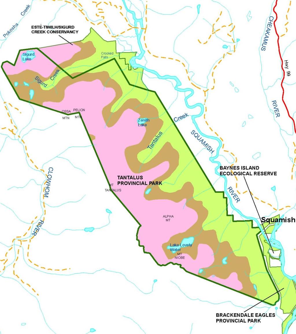
19 Figure 5: Biogeoclimatic Zones Tantalus Park Map 12
20 2.4 Recreation Baynes Island Ecological Reserve Access to Baynes Island Ecological Reserve for recreational activities is not encouraged. Brackendale Eagles Park Brackendale Eagles Park has a history of low recreational use. Small numbers of visitors engage in activities along the river and gravel beach areas, including fishing, canoeing, river rafting and wildlife viewing. Brackendale Eagles Park provides significant opportunities to view wintering Bald Eagles which can be enjoyed from areas outside the park boundary. Adjacent areas along the east bank of the Squamish River have seen significant increases in recreational use associated with viewing of wintering Bald Eagles and their habitat. Human presence in both upland and shoreline areas can disturb and stress wintering Bald Eagles at a particularly vulnerable stage in their life cycle. At present, the public viewing areas are located opposite the park on the east side of the river. As a result, impacts on the eagles and their wintering habitat within the park are minimised. In the past there has been interest in a pedestrian crossing over the Squamish River for recreational access. One proposal identified a crossing at the south end of Brackendale Eagles Park, providing access to the Fries Creek area and the south end of the Tantalus Range. Although the purpose of the crossing was not specifically intended to promote use within Brackendale Eagles Park, easier access across the river would encourage additional recreational use on the west side of the river. Any additional use within the park would have significant potential to disrupt and impact wintering bald eagles. By protecting key Bald Eagle habitat, Brackendale Eagles Park supports commercial recreation and provides wildlife viewing opportunities for commercial operators using the viewing areas on the east side of the river. The Squamish River offers good sport fishing opportunities for Pacific Salmon and a variety of trout, including Lake Trout (Char). Fishing occurs primarily from the eastern shore of the river but occasionally by boat or from the gravel bars on the western shore. Anglers can disrupt eagle feeding and roosting activities by their presence and activities within the eagle wintering habitat. Brackendale Eagles Park is part of Wildlife Management Unit 2-6. Historically hunting activity within Brackendale Eagles Park has been low. Commercial river rafting companies operate on the lower Squamish River. Commercial trips that land within the boundaries of the park require a valid park use permit. To date, no companies have applied for, or been issued, park use permits for this activity. 13
21 Tantalus Park Tantalus Park has a long history of recreational use that began in 1911 when its highest peak, Mt. Tantalus, was first ascended. Access to the park was initially gained by crossing the Squamish River and then hiking into base areas. In the 1930s a trappers /prospectors trail to the upper Sigurd Creek valley was cut out and later used by climbers and hikers. Over time a rough recreational trail was developed to Lake Lovely Water. Over the decades, the popularity of the area has grown, particularly as a destination for mountaineering activities. Hiking and fishing also became established activities in the Lake Lovely Water area. Lake Lovely Water and the peaks and glaciers of the Tantalus Range are the dominant recreational features. Tantalus Park provides high quality mountaineering opportunities in a wilderness setting, accessible on a two to three day trip from Vancouver. Historically, the majority of use of the Tantalus area has been centred on the Lake Lovely Water area. Lake Lovely Water offers opportunities for mountaineering, overnight hiking, and backcountry camping. In 1961, the Alpine Club of Canada built a backcountry cabin near the outlet creek at the lake. In 2005, the Alpine Club of Canada also built a cabin (Haberl Hut) just outside the park boundary at the Serratus-Dione col, about a six-hour hike above the Lake Lovely Water cabin. There are a few developed campsites adjacent to the Alpine Club of Canada cabin at Lake Lovely Water. There are no developed sites elsewhere in the park although camping does occur in many dispersed locations. There is a primitive trail system within the Lake Lovely Water area. The area around Sigurd Lake and creek offers opportunities for overnight hiking, backcountry camping, mountaineering and backcountry skiing. Present facilities include the Sigurd Creek trail to the Mt. Pelion and Mt. Ossa area. The trailhead and first half of the Sigurd Creek trail are within the Esté-tiwilh/Sigurd Creek Conservancy. Hiking trails within the park are poorly developed and difficult, and are generally most suitable for intermediate or experienced hikers. The trails in the park are relatively unique in the Vancouver region in that they travel through essentially undisturbed forest from near sea level to alpine regions. Existing trails currently see moderate levels of use. However, due to the close proximity to the Lower Mainland and the Sea to Sky Corridor, the use of these trails is expected to increase as they become better known. This is particularly true of the Lake Lovely Water access trail if the trailhead and river crossing are better established. There are other routes in the park (e.g., Henrietta Lake near Woodfibre to Lake Lovely Water) but these involve route finding and mountaineering skills. Due to the steepness of the terrain and difficulty in gaining access across the Squamish River, it is generally not feasible to develop additional trails. Exceptions to this may be a trail from Pokosha Creek to the Sigurd Lake area and a trail from the Squamish River to Zenith Lake. The park is isolated by the Squamish River and by the severity of the terrain. Access to the park is generally gained by the Lake Lovely Water access trail, the Sigurd Creek trail or by air. Both air 14
22 and hiking access are important and appropriate methods to access the park. Approximately 40% of park visitors use aircraft-supported access. Over the last three decades both hiking and air access have become more popular. The trailhead and parking area for the Lake Lovely Water access trail is located on Indian Reserve #11 on the east side of the Squamish River. Users then cross the Squamish River by boat and then hike across private land before entering the park. At this time there are no agreements in place with either the Squamish Nation or the private landowner for continued access across their properties. Only the northern boundary of the park can be reached by vehicle. From the upper Squamish Valley road, park visitors can access the Ashlu River Forest Service Road (FSR). Off the Ashlu River Forest Service Road, a rough spur road goes to the Sigurd Creek trailhead and the northern boundary of Esté-tiwilh/Sigurd Creek Conservancy. A rough trail from this location goes south and west through the conservancy to a crossing of Sigurd Creek that provides access to Ossa and Pelion mountains within Tantalus Park. The park provides spectacular viewing opportunities both within the park and of the park itself from nearby viewing areas. The mountains, glacial features, lakes and low elevation forests provide key landscape values. Significant viewpoints are at Lake Lovely Water, from the upper Squamish Valley Road and from the Tantalus Viewpoint on Highway 99 outside of the park. Much of the land adjacent to the park is not protected making it difficult to preserve the viewscape from the park. The Squamish River valley, Stawamus Chief Park and Garibaldi Park to the east do provide outstanding viewing opportunities for park visitors. Commercial recreation opportunities in Tantalus Park are focussed on guided mountaineering and aircraft-based recreation. Guiding for hiking or backpacking can occur but will be limited by the lack of trail systems and the severity of the terrain. Commercial operators, including guides, can provide a diversity of recreational opportunities and enhanced experiences for park visitors. Areas adjacent to the park are heavily used for mechanised and non-mechanised commercial recreation including river rafting, heli-hiking, all-terrain vehicle tours and other operations. The Canada West Mountain School and the Association of Canadian Mountain Guides have park use permits for commercial guiding. As well, the Alpine Club of Canada holds a park use permit for the cabin at Lake Lovely Water. This area has been a destination for commercial aircraft sightseeing tours since the 1980s. The Squamish airport is located to the southeast of the park and provides a base for quick helicopter access. Landing locations include Lake Lovely Water, higher elevation drop off areas for mountaineers, and sightseeing points for day users. Floatplanes generally come from either Whistler or the Vancouver area to land at Lake Lovely Water. Air access is not allowed at Sigurd Lake. Commercial flights occur in Tantalus Park under park use permits which are issued on an annual basis. 15
23 In June 2003, an Aviation for Tantalus Park was developed by BC Parks with input from a stakeholder group. The plan outlines guidelines for the management of commercial aircraft access and use over Tantalus Park. These guidelines are designed to minimize the impacts of aircraft access and use on wildlife and recreational experiences. The stakeholders generally agreed that private aircraft use is not an issue at this time. Lake Lovely Water has been stocked with Rainbow Trout and provides good fishing opportunities. Fishing generally occurs from the shore or from small rowboats kept at the Alpine Club of Canada cabin. There is no fishing known to occur in any of the other lakes or streams found in the park. Tantalus Park is included as part of Wildlife Management Unit 2-6. Species currently open to harvest (subject to regulations) include Black-tailed Deer, Black Bear, Wolf, Coyote, Racoon, Skunk, Snowshoe Hare, Bobcat, Cougar, upland game birds and waterfowl. Current hunting pressure within the park is unknown but is likely light in comparison to other areas in this management unit. Figure 6 shows the recreational facilities, including approved fixed wing and helicopter landing sites located within the park. 16


24 Figure 6: Recreational Facilities in Tantalus Park Map 17
25 3.0 Management Direction 3.1 Vision The purpose of the vision statement is to identify the role and function of the protected areas beyond the life of the management plan. The vision statement is forward-looking and describes the desired future for the protected areas. A clear vision provides the context to guide the short-term and long-term management of a protected area. Tantalus Park, Brackendale Eagles Park and Baynes Island Ecological Reserve contribute significantly to the conservation, cultural heritage and recreation values on regional, provincial, national, and international levels. While the three protected areas have differing main purposes, the collective area is managed recognising that values transcend boundaries. Public and commercial activities are in harmony with natural and cultural values and are sustainable. The protected areas are managed in a manner that protects and enables their continued use and enjoyment by First Nations for hunting, fishing and other social, ceremonial, and sustenance purposes, subject to conservation and public safety. Of particular importance is the relationship between the Squamish Nation and the Squamish River and floodplain including the importance of salmon and floodplain vegetation. Tantalus Park offers exceptional mountaineering as well as landscape viewing, hiking, and fishing in a wilderness setting. The old-growth coastal forest ecosystem is managed to maintain important wildlife and vegetation values. Access is by both foot and air, and is managed to minimise impacts to backcountry values while offering opportunities to enjoy the mountain peaks and glaciers. Brackendale Eagles Park is a core area of important habitat for wintering Bald Eagles each year from October to March. Management actions ensure that feeding, perching and roosting habitats are protected and that Bald Eagle viewing opportunities are encouraged from areas outside the park. BC Parks works closely with the community of Squamish, Squamish Nation, and other agencies and groups to raise awareness about the importance of this natural phenomenon and ensure that the area remains recognised as internationally important. Recreation does not occur in the park during the winter months while the eagles are present. When recreation does occur it will be limited to low intensity, sustainable activities that require no facilities. Baynes Island Ecological Reserve protects the black cottonwood floodplain ecosystem. Recreation is not encouraged on Baynes Island but opportunities for scientific study and research are permitted to enhance scientific knowledge of low elevation coastal floodplain ecology. 18
26 3.2 Collaborative Management with Squamish Nation Under the Squamish Nation British Columbia Collaborative Agreement for the Management of Protected Areas in Squamish Nation Traditional Territory, the parties have committed to joint development and/or review of protected area management plans. This management plan reflects Squamish Nation s input. Currently, Squamish Nation is involved in treaty negotiations with senior levels of government. Squamish Nation s contributions to this management plan are recognised and understood to be without prejudice to future treaty negotiations. Once formal treaty agreements have been reached with Squamish Nation, this management plan will be reviewed to determine whether it is in compliance with treaty. If it is not in compliance, then the management plan will be revised accordingly. Any changes will be made through a public process to build understanding of what any changes may mean to the protected areas and their use. Objectives To maintain ongoing communication and working relationships with the Squamish Nation whose traditional territory includes the BEBIT protected areas. Strategies Manage the BEBIT protected areas in a manner consistent with the Collaborative Agreement for the Management of Protected Areas in Squamish Nation Traditional Territory. 3.3 Cultural Heritage Management Brackendale Eagles Park and Baynes Island Ecological Reserve Objectives Identify, protect and present, as appropriate, significant cultural features and values including traditional uses practiced by First Nations in Brackendale Eagles Park. Strategies Work with Squamish Nation to identify and inventory traditional use areas, and cultural, spiritual and sustenance resources. Develop protocols for the continued practice of traditional activities by present and future generations of First Nations. Provide Squamish Nation with priority access to Bald Eagle carcasses and/or feathers. 19
27 Tantalus Park Objectives Identify and protect significant cultural features and values including traditional use patterns by First Nations in the park area. Provide First Nations with access to land and resources within the protected areas for food, social, and ceremonial purposes, subject to conservation and public safety. Strategies Work with Squamish Nation to identify and inventory traditional use areas, and cultural, spiritual and sustenance resources. Develop strategies that ensure the continued opportunity to practice traditional activities by present and future generations of First Nations. Manage areas of Tantalus Park that are adjacent to the Esté-tiwilh/Sigurd Creek Conservancy in a manner that is consistent with the values and management direction of the conservancy. 3.4 Biological Diversity and Natural Environment Management Brackendale Eagles Park and Baynes Island Ecological Reserve Objectives Encourage and contribute to maintaining healthy freshwater systems, including water quality and quantity. Protect important fish habitats within the protected areas including Squamish River spawning gravels, rearing areas and side channels. Conserve the naturally occurring diversity and succession within the protected areas. Maintain natural ecosystem processes while protecting the important riparian and floodplain forests along the Squamish River. Preserve old-growth forest ecology within the ecological reserve for research and education purposes. Strategies Implement management strategies that protect water resources and monitor for impacts to water quality and quantity. Work closely with other agencies and adjacent landowners to manage water resources that extend across protected area boundaries. Encourage management approaches that will not adversely impact water resources. Implement the fire management plan in conjunction with other relevant provincial agencies. Work cooperatively with other agencies and adjacent landowners to manage vegetation values that extend across protected area boundaries. Encourage management approaches that will not adversely impact protected area values. Work cooperatively with other agencies, organisations and individuals to identify, research and monitor vegetation, particularly any rare or endangered species or plant communities. 20
28 Brackendale Eagles Park and Baynes Island Ecological Reserve (cont.) Objectives Protect the ecological integrity of the park and ecological reserve. Strategies Provide input into activities for adjacent areas to ensure values associated with the park and ecological reserve are considered. Encourage agencies, organisations and participants to adopt management approaches that will not adversely impact protected area values. As feasible, on a willing seller-willing buyer basis acquire adjacent private lands (including PIDs , , , , , , and ) and recommend that the lands be added to the park. Maintain the existing diversity of wildlife species in the protected areas and sustain current wildlife populations. Protect the habitats associated with perching, roosting and feeding areas for wintering Bald Eagles. Work closely with other agencies and adjacent landowners to manage wildlife values that extend across protected area boundaries. Encourage management approaches that will not adversely impact wildlife values. Discourage or restrict recreational activities and use that may disrupt wintering Bald Eagles or the floodplain habitat. Work to identify, research and monitor wildlife, particularly species at risk. Tantalus Park Objectives Maintain the freshwater systems and watersheds of the park in their natural condition, free from contaminants or pollution. Maintain water quality and quantity in the park to sustain wildlife and maintain human health and aesthetic values. Strategies Develop a baseline inventory of water quality at Lake Lovely Water. Ensure sanitary facilities are properly designed, located away from water sources and well managed and maintained. Ensure park developments are constructed and maintained to minimise soil erosion and runoff. Provide the public with information on minimising impacts to water quality in the backcountry. Prohibit fish stocking in alpine or sub-alpine lakes other than Lake Lovely Water. 21
29 Tantalus Park (cont.) Objectives Conserve the naturally occurring biodiversity and succession of plant associations within the park. Maintain natural ecosystems processes while protecting the important riparian and floodplain forests along the Squamish River. Strategies Protect the integrity of the forests including important wildlife habitats. Consider impacts to forested ecosystems, including old-growth forest, within the park when assessing development plans or new recreational facilities. Work cooperatively with agencies, organizations and individuals to identify, research and monitor vegetation, particularly rare or endangered species or plant communities. Work cooperatively with other agencies to manage vegetation values that extend across park boundaries. Encourage management techniques that will not adversely impact park values. Maintain the existing diversity of wildlife species in the park and sustain current wildlife population levels. Identify and protect the habitats associated with wintering Bald Eagles. Ensure any new trails or facilities are planned and managed in a manner that is sensitive to the habitats and requirements of wildlife. Work cooperatively with other agencies to manage wildlife values that extend across park boundaries. Encourage management approaches that will not adversely impact wildlife values. Undertake surveys of key wildlife species within the park and determine important habitat areas. Identify areas within the park which are utilized by wintering Bald Eagles and manage for these values. Work cooperatively with agencies, organisations and individuals to identify, research and monitor wildlife, particularly rare or endangered species or wildlife habitats. 22
30 3.5 Recreation Management The following sections outline the types of recreation opportunities in each protected area, associated objectives, and the facilities or services required for each opportunity. Before any facilities are developed or altered, an impact assessment is required to determine what impacts may occur, and what adjustments should be made to minimise impacts. Brackendale Eagles Park and Baynes Island Ecological Reserve Objectives Prevent human activities from impacting on wintering Bald Eagles and their habitat within the upland and shoreline areas. Strategies Do not encourage access to Baynes Island Ecological Reserve for recreational activities. Do not develop recreation facilities within the park. Recreational use will not be encouraged or promoted within any part of the park. Recreation activities will be managed to maintain the present low numbers and low intensity of use. Discourage or restrict recreational activities that may disrupt wintering Bald Eagles or the floodplain habitat in Brackendale Eagles Park. Recreational use, except for fishing, will be closed from October 1 to March 31 of each year within those parts of Brackendale Eagles Park that lie on the western side of the Squamish River. Consult with the relevant provincial agency, Fisheries and Oceans Canada and angling groups regarding the implementation of fishing closures that match the above general recreation closure. Guided angling will be subject to seasonal fishing closures. Only small guided angling parties (of up to four people) are acceptable. From April 1 to September 30, those parts of Brackendale Eagles Park that lie on the western side of the Squamish River will be open to low intensity, low use recreation. This area will be closed to campfires, overnight camping, trail development, mountain biking, horseback riding and mechanised recreation. 23
31 Brackendale Eagles Park and Baynes Island Ecological Reserve (cont.) Objectives Strategies (cont.) Prevent and control any impacts to wintering Bald Eagles from a proposed future pedestrian bridge crossing upon the park. Commercial river rafting operators will not be permitted to land anywhere in the park during the recreational closure period from October 1 to March 31. Water access to Brackendale Eagles Park will be restricted to non-motorised water craft (e.g., canoes, river rafts). In cooperation with community volunteers, BC Parks will monitor impacts from recreation and, where impacts are found, will undertake appropriate actions to control impacts. These actions could include signage, rehabilitation or recreational closures. Recreational use within those parts of the park that lie on the east side of the Squamish River will be managed to protect wintering eagles and their habitat. Encourage bridge proponents to place the crossing outside the park. Prior to considering a crossing location within the park, proponents would have to demonstrate that there is no other feasible crossing point. If the placement of the crossing is to be considered within the park, the project would undergo an impact assessment on the structure and on the crossing site to assess potential impacts on values within the park. Protection of park values, including Bald Eagle habitat, would be the first priority within the assessment and in any potential mitigation actions. Control over recreational use would be considered an important mitigation action. Protect the Bald Eagle viewing opportunities. Work co-operatively with agencies involved in adjacent development to incorporate appropriate visual management considerations. Encourage viewing of park resources, including Bald Eagles and their habitat, from outside the park. This could be from the eastern shore of the Squamish River or from appropriately conducted river rafting trips. 24
32 Brackendale Eagles Park and Baynes Island Ecological Reserve (cont.) Objectives Due to the small size of the park and the seasonal closure of the upland areas to recreational use, maintain the closure of the park to hunting. Support appropriate commercial recreation while protecting the natural values of the park. Provide visitor information that enhances visitor experiences and protects the values of the park and ecological reserve. Strategies Ensure that the closure of the park to hunting is maintained, other than for First Nations for food, social and ceremonial purposes. Do not permit commercial activities in the upland areas of the park. The use of the area for river rafting is supported if appropriate wildlife viewing practices are followed. Work with commercial operators and stakeholders to encourage appropriate viewing practices. Provide Squamish Nation with enhanced access to compatible economic opportunities in the park consistent with the Collaborative Agreement for the Management of Protected Areas in Squamish Nation Traditional Territory. This may include guided fishing and nature viewing. Do not permit commercial filming in order to protect conservation values. Do not promote use and visitation of the park and ecological reserve. Information based on interpretive themes will be provided to enhance the visitors experiences. Information will be provided at viewing sites outside the park through cooperation with the District of Squamish and other key groups. Interpretive themes will focus on the eagles and the floodplain ecosystem, with reference to the cultural importance of the area to the Squamish Nation and their long history of occupation and use of the Squamish River. Although the Bald Eagles are an important and dominant theme, other elements of the ecosystem (e.g., the importance of salmonids and black cottonwood forests) should also be addressed. Deliver park messages in cooperation with other agencies and non-governmental organisations (e.g., Eagle Watch). Access to the viewing sites on the east side of the river is well signed within the District of Squamish, and highway signs are not required. 25
33 Brackendale Eagles Park and Baynes Island Ecological Reserve (cont.) Objectives Strategies (cont.) Provide only regulatory signs within the park. Include the park in standard BC Parks brochures, maps website. Tantalus Park BC Parks recognises the wide variety of public and commercial recreation that has historically occurred in the Tantalus Range. However, increasing use has lead to occasional conflicts between mechanised (aircraft) and non-mechanised users. BC Parks will implement strategies that allow for continued recreational use while minimising impacts to the park s values. Objectives Continue to provide both hiking and air access into Tantalus Park while minimizing potential conflicts between access methods. Strategies BC Parks and Squamish Nation will explore options to establish a protocol to improve public access to the Lake Lovely Water trailhead and river crossing through Indian Reserve #11 and the Squamish West Síiyamín ta Skwxwú7mesh cultural site. Discuss options with the private landowner of District Lot 1510 to secure a hiking trail corridor for the beginning of the Lake Lovely Water trail where it crosses private land. If the above options are not feasible, investigate alternative access to Lake Lovely Water from the Squamish River. Manage aircraft access in accordance with the Aviation (2003). This plan includes direction such as: Floatplane access will continue at Lake Lovely Water but changes will be considered on shore landing sites and use patterns to control impacts. Helicopter access will continue at Lake Lovely Water and identified sites within the Lake Lovely Water basin and identified sites within the Nature Recreation Zone. The Wilderness Recreation Zone will be closed to public and commercial aviation use. Develop guidelines for boating on Lake Lovely Water consistent with the Aviation. 26
34 Tantalus Park (cont.) Objectives Protect viewing opportunities and viewscapes towards, and from, the park. Provide a variety of mountaineering experiences. Maintain and improve the opportunities for hiking within the park. Strategies Work cooperatively with agencies involved in adjacent development to incorporate appropriate visual management considerations. Ensure any proposed development or facilities in the park are aesthetically pleasing and blend with the natural environment. Work cooperatively with other agencies to ensure park messages are considered in the provision of viewing opportunities at the Tantalus Viewpoint on Highway 99 and at other locations. Encourage the continued presence of the Alpine Club of Canada cabin at Lake Lovely Water and the high-elevation Haberl Hut just west of the park. Work with the mountaineering community and other users to maintain the quality of the experience while minimizing environmental impacts. Maintain and manage the trails within the park to minimize environmental impacts, increase public safety and improve the quality of the visitor experience. Complete a trail plan for the trails and routes located within the Lake Lovely Water basin. Identify requirements and opportunities for trail relocations and improvements, including a new trail that avoids the Special Feature Zone. Consider trail improvements in the Sigurd Lake area. A rough trail that used to provide access to Sigurd Lake is no longer maintained, but should be reviewed in the future, and upgraded should use and interest warrant it. In cooperation with mountaineering and hiking groups, assess the opportunity for a connecting trail to the Pokosha Creek area from Sigurd Creek in the adjacent Esté-tiwilh/Sigurd Creek Conservancy and from the Squamish River to Zenith Lake. If these trails are shown to be feasible, then develop the trails as resources allow. 27
35 Tantalus Park (cont.) Objectives Provide wilderness camping opportunities for hikers and mountaineers while minimising environmental impacts. Maintain hunting as an acceptable activity within the park so long as wildlife populations are sustainable. Manage Lake Lovely Water for a high quality recreational fishery in conjunction with the provincial fisheries program. Strategies Design a site plan for the area at the mouth of Lake Lovely Water including the Alpine Club of Canada cabin and existing campsites. Within this plan identify trails, locations for toilet facilities, and up to 20 campsites. Assess the needs and impacts of wilderness camping at the undeveloped sites and provide facilities as required (e.g., pit toilets, designated campsites). Where facilities are not appropriate (e.g., high bivouac sites) encourage and provide information to users on appropriate camping and sanitation measures. Explore the possibility of a wilderness campsite for the Sigurd Creek/Sigurd Lake area. Close the park to campfires. The Lake Lovely Water cabin will continue to be managed by the Alpine Club of Canada under a park use permit, and will provide overnight accommodation for both members and nonmembers under the administration of the club. The Lake Lovely Water cabin is the only backcountry cabin/hut permitted in the park (the Serratus-Dione col is serviced by the Haberl Hut which is situated outside the park boundary). Mountain biking, snowmobiling, and the use of horses or other pack or riding animals are not appropriate activities in the park. Monitor wildlife populations to determine and inform decisions around hunting opportunities, seasons and quotas. Permit fish stocking only in Lake Lovely Water. Develop a fisheries management plan for Lake Lovely Water that builds on current knowledge and addresses lake stocking requirements, guided angling, habitat protection and enhancement priorities. 28
36 Tantalus Park (cont.) Objectives Allow for commercial recreation opportunities that enhance the recreational experience for park visitors while minimising environmental, cultural and social impacts. Provide Squamish Nation with enhanced access to compatible economic opportunities in the protected area, consistent with the Collaborative Agreement for the Management of Protected Areas in Squamish Nation Traditional Territory. Strategies Assess new commercial recreation proposals (e.g., heli-hiking) in the park and consider park use permit applications that meet the direction in the management plan, are consistent with the Squamish Nation/BC Parks collaborative management agreement, are considered low impact through BC Parks impact assessment process, maintain the values of the park and conform to the direction in the management plan. Provide visitor information which enhances the visitors experiences and protects the park values. BC Parks will assist with the provision of interpretive messages outside the park. There will be no interpretive signage in the park itself, although interpretive messages may be included in park brochures or other information sources. The most appropriate site for interpretive signage and messages is located outside of the park at the Tantalus Viewpoint on Highway 99. Key interpretive themes include the geology of the Coast Range, glaciology, climate change, attributes of the ecosystems of the Squamish River valley from floodplain to alpine areas, the recreational features of Tantalus Park with a particular focus on its mountaineering history, and the cultural significance of these landscapes to the Squamish Nation. 3.6 Zoning Zoning assists in the planning and management of protected areas by communicating and focusing management direction in particular areas using a landscape level approach. Management objectives for a spatial area describe the desired natural environment conditions and visitor experience opportunities on a given landscape. Refer to Appendix A for more information on appropriate uses in the different zones. 29
37 Brackendale Eagles Park Brackendale Eagles Park is managed as a single zone, the Special Feature Zone. This zone includes all of the area found within Brackendale Eagles Park. The size of this zone is 755 hectares. The objective of this zone is to protect Bald Eagles, Bald Eagle habitat and the floodplain ecosystem found within Brackendale Eagles Park, and the First Nations cultural values associated with this area and its features. Activities within the zone will be managed to protect the natural values of the park and to maintain low intensity recreational use. The Special Feature Zone was applied for the following reasons: The primary management direction will be the protection of Bald Eagles, Bald Eagle habitat and the associated floodplain ecosystem. The area will be managed without facility development or intensive use. The area is relatively small and will be managed as a single unit. Baynes Island Ecological Reserve The intent of ecological reserves is to preserve representative and special natural ecosystems, plant and animal species, features and phenomena. Ecological reserves prohibit consumptive uses; scientific research and education are the two principle uses. The purpose of the Baynes Island Ecological Reserve is to preserve floodplain cottonwood stands and associated natural values in the lower Squamish River valley. BC Parks zoning framework does not apply to ecological reserves so no zoning has been applied to Baynes Island Ecological Reserve. Appendix A indicates the activities that are appropriate in the ecological reserve. Tantalus Park Tantalus Park is managed under three zones: Nature Recreation, Wilderness Recreation and Special Feature (Figure 5). Nature Recreation Zone This zone covers the area primarily above the Mountain Hemlock Biogeoclimatic Zone. This zone includes 5,830 hectares and covers about 51% of the park. The objective of this zone is to protect scenic values, cultural values and to provide for backcountry recreation opportunities in a largely undisturbed natural environment. The portion of the park zoned Nature Recreation accommodates the more heavily used and developed portions of the park which are found in the elevations in, or above, the subalpine 30
38 level. This zone allows for appropriate recreation developments at Lake Lovely Water and the continued aircraft access. This zone will be managed for moderate levels of use and facility development and for access by foot or air. The principal forms of development will be hiking trails to Lake Lovely Water from the Squamish River, a hiking trail system and a wilderness campground in the Lake Lovely Water basin, and the Alpine Club of Canada cabin. No trail development will occur within this zone outside of the Lake Lovely Water basin and Lake Lovely Water access trail. Appendix 1 provides further information on the activities within this zone. Wilderness Recreation Zone This zone consists of the Coastal Western Hemlock Biogeoclimatic Zone, the lower elevations of the Mountain Hemlock Biogeoclimatic Zone, and the Alpine Tundra Biogeoclimatic Zone around Sigurd Lake. This zone encompasses 5,510 hectares; approximately 49% of the park. The objective of this zone is to protect a remote, undisturbed natural landscape and to provide backcountry recreation opportunities dependent on a pristine environment. This portion of the park is zoned Wilderness Recreation to provide a more solitary and remote experience than found elsewhere in the park. Facility development will be limited and access will be non-motorised only. This zone will be managed for low levels of development and for access and use by foot only. Trail development will be limited to the access trail from Squamish River to Lake Lovely Water, the Sigurd Creek trail and possibly future trail connections between Pokosha Creek and Sigurd Lake, and a trail to Zenith Lake. Facility development will be limited to campsites at Sigurd Creek or Sigurd Lake and possibly Zenith Lake. Special Feature Zone The objective of this zone is to protect and preserve the significant natural values found in the wet subalpine meadow in the Niobe basin to the northwest of Omega Mountain. This 14 hectare area of the park is zoned Special Feature to protect the fragile vegetation from trail development and use. This zone will be managed for no facility development, including trails, and for very limited human use within the meadow area. Hikers and mountaineers will be encouraged, by the use of signage and other messaging, to bypass the meadow using adjacent upland areas. 31


39 Figure 7: Zoning Map Tantalus Park. 32
MARBLE RIVER PROVINCIAL PARK
 MARBLE RIVER PROVINCIAL PARK PURPOSE STATEMENT AND ZONING PLAN March 2003 MARBLE RIVER PROVINCIAL PARK Purpose Statement and Zoning Plan Primary Role The primary role of Marble River Park is to protect
2.0 PARK VISION AND ROLES
 2.0 PARK VISION AND ROLES 2.1 Significance in the Protected Area System Marble Range and Edge Hills provincial parks protect 6.8% of the Pavillion Ranges Ecosection, which is located in the Southern Interior
Mackinnon Esker Ecological Reserve Draft - Management Plan
 Mackinnon Esker Ecological Reserve Draft - Management Plan May 2011 Photo Credit: This document replaces the direction provided in the Carp Lake Provincial Park and Protected Area and Mackinnon Esker Ecological
MANAGEMENT DIRECTION STATEMENT June, 1999
 Thompson River District MANAGEMENT DIRECTION STATEMENT June, 1999 for Clearwater River Corridor (Addition to Wells Gray Park) Ministry of Environment Lands and Parks BC Parks Division ii Table of Contents
MANAGEMENT DIRECTION STATEMENT
 Skeena District MAAGEMET DIRECTIO STATEMET July, 2000 for Driftwood Canyon Provincial Park Ministry of Environment Lands and Parks BC Parks Division i Table of Contents Driftwood Canyon Park Approvals
MAIN LAKE PROVINCIAL PARK
 MAIN LAKE PROVINCIAL PARK PURPOSE STATEMENT AND ZONING PLAN March 2003 MAIN LAKE PROVINCIAL PARK Purpose Statement and Zoning Plan Primary Role The primary role of Main Lake Park is to protect a biologically
ANAGEMENT P LAN. February, for Elk Lakes and Height of the Rockies Provincial Parks. Ministry of Environment, Lands and Parks BC Parks Division
 M ANAGEMENT P LAN February, 1999 for Elk Lakes and Height of the Rockies Provincial Parks Ministry of Environment, Lands and Parks BC Parks Division Elk Lakes & Height of the Rockies Provincial Parks M
Role of the Protected Area
 Role of the Protected Area Provincial and Regional Context Height of the Rockies and Elk Lakes provincial parks lie in southeastern British Columbia in the Rocky Mountains, about 85 km southwest of Calgary,
As outlined in the Tatshenshini-Alsek Park Management Agreement, park management will:
 Management Strategy General Strategy The priority management focus for the park is to ensure that its internationally significant natural, cultural heritage and recreational values are protected and that
MANAGEMENT DIRECTION STATEMENT March 2003
 Skeena Region MAAGEMET DIRECTIO STATEMET March 2003 for Meziadin Lake Provincial Park Ministry of Water, Land and Air Protection Environmental Stewardsh Division This page left blank on purpose ii Table
Bridge River Delta Park. Management Plan. Final Public Review Draft
 Bridge River Delta Park Management Plan Final Public Review Draft March 2016 Bridge River Delta Park Management Plan Approved by: Jeff Leahy Regional Director Thompson Cariboo Region BC Parks Date Brian
Appendix A BC Provincial Parks System Goals
 Appendix A BC Provincial Parks System Goals The British Columbia Provincial Parks System has two mandates: To conserve significant and representative natural and cultural resources To provide a wide variety
D IRECTION S TATEMENT
 Vancouver Island Region M ANAGEMENT D IRECTION S TATEMENT September 2003 for Lower Nimpkish Provincial Park Ministry of Water, Land and Air Protection Environmental Stewardship Lower Nimpkish Provincial
MANAGEMENT DIRECTION STATEMENT June, 1999
 Thompson River District MANAGEMENT DIRECTION STATEMENT June, 1999 for Roche Lake Provincial Park Ministry of Environment Lands and Parks BC Parks Division Table of Contents I. Introduction A. Setting
Marchand Provincial Park. Management Plan
 Marchand Provincial Park Management Plan 2 Marchand Provincial Park Table of Contents 1. Introduction... 3 2. Park History... 3 3. Park Attributes... 4 3.1 Natural... 4 3.2 Recreational... 4 3.3 Additional
MANAGEMENT DIRECTION STATEMENT
 Lower Mainland District MAAGEMET DIRECTIO STATEMET January 2001 for Liumchen Ecological Reserve Ministry of Environment Lands and Parks BC Parks Division Table of Contents Page Introduction... 1 Purpose
Outdoor Recreation Opportunities Management
 Outdoor Recreation Opportunities Management Introduction The natural features of Height of the Rockies and Elk Lakes provincial parks provide a wide variety of outdoor recreational activities. However,
MANAGEMENT DIRECTION STATEMENT June, 1999
 Garibaldi/Sunshine Coast District MAAGEMET DIRECTIO STATEMET June, 1999 for Homathko Estuary Provincial Park Ministry of Environment Lands and Parks BC Parks Division TABLE OF COTETS Introduction...1
5.0 OUTDOOR RECREATION OPPORTUNITIES AND MANAGEMENT
 5.0 OUTDOOR RECREATION OPPORTUNITIES AND MANAGEMENT 5.1 Introduction This section describes the range of recreational activities that currently take place in Marble Range and Edge Hills Parks, as well
FINGER-TATUK PROVINCIAL PARK
 FINGER-TATUK PROVINCIAL PARK PURPOSE STATEMENT AND ZONING PLAN March 2003 FINGER-TATUK PROVINCIAL PARK Purpose Statement and Zoning Plan Finger-Tatuk Provincial Park is 17,151 ha in size. It includes the
Yard Creek Provincial Park. Management Plan
 Yard Creek Provincial Park Management Plan Draft January 2010 Yard Creek Provincial Park Management Plan Approved by: telàlsemkin/siyam/chief Scott Benton Bill Williams Squamish Executive Director ation
CARMANAH WALBRAN PROVINCIAL PARK
 CARMANAH WALBRAN PROVINCIAL PARK PURPOSE STATEMENT AND ZONING PLAN September 2003 1 CARMANAH WALBRAN PROVINCIAL PARK Purpose Statement and Zoning Plan Carmanah Walbran Provincial Park is an expansion of
Pillar Park. Management Plan
 Pillar Park Management Plan January 2014 Pillar Park Management Plan Approved by: Jeff Leahy Regional Director Thompson Cariboo Region BC Parks January 9, 2014 Date Brian Bawtinheimer Executive Director
ANAGEMENT P LAN. July for Chilliwack Lake Park & Chilliwack River Ecological Reserve. Ministry of Environment, Lands and Parks BC Parks Division
 M ANAGEMENT P LAN July 2000 for Chilliwack Lake Park & Chilliwack River Ecological Reserve Ministry of Environment, Lands and Parks BC Parks Division Chilliwack Lake Provincial Park & Chilliwack River
OMINEACA PROVINCIAL PARK
 OMINEACA PROVINCIAL PARK AND PROTECTED AREA PURPOSE STATEMENT AND ZONING PLAN March 2003 OMINECA PROVINCIAL PARK AND PROTECTED AREA Purpose Statement and Zoning Plan Omineca Park and Omineca Protected
SUGARBOWL-GRIZZLY DEN PROVINCIAL PARK AND SUGARBOWL-GRIZZLY DEN PROTECTED AREA Purpose Statement and Zoning Plan
 SUGARBOWL-GRIZZLY DEN PROVINCIAL PARK AND SUGARBOWL-GRIZZLY DEN PROTECTED AREA Purpose Statement and Zoning Plan Located one hour east of Prince George on Highway 16, Sugarbowl-Grizzly Den Provincial Park
ANAGEMENT. LAN November, 1996
 M ANAGEMENT P LAN November, 1996 for Paul Lake Provincial Park Ministry of Environment, Lands and Parks BC Parks Department Paul Lake Provincial Park M ANAGEMENT P LAN Prepared by BC Parks Kamloops Area
Fred Antoine Park. Management Plan. Final Public Review Draft
 Fred Antoine Park Management Plan Final Public Review Draft March 2016 Fred Antoine Park Management Plan Approved by: Jeff Leahy Regional Director Thompson Cariboo Region BC Parks Date Brian Bawtinheimer
PROUDLY BRINGING YOU CANADA AT ITS BEST. Management Planning Program NEWSLETTER #1 OCTOBER, 2000
 PROUDLY BRINGING YOU CANADA AT ITS BEST VUNTUT NATIONAL PARK Management Planning Program NEWSLETTER #1 OCTOBER, 2000 INTRODUCTION This newsletter launches the development of the first management plan for
Wallace Lake Provincial Park. Management Plan
 Wallace Lake Provincial Park Management Plan 2 Wallace Lake Provincial Park Table of Contents 1. Introduction... 3 2. Park History... 3 3. Park Attributes... 4 3.1 Natural... 4 3.2 Recreational... 4 4.
Qwalímak/Upper Birkenhead Conservancy. Management Plan
 Qwalímak/Upper Birkenhead Conservancy Management Plan March 2012 Cover photo: Upper Birkenhead River Photo credit: Liz Scroggins Qwalímak/Upper Birkenhead Conservancy Management Plan Acknowledgements
ROBERTS CREEK PROVINCIAL PARK MASTER PLAN. November, 1981
 Ministry of Lands, Parks and Housing Parks and Outdoor Recreation Division Park Operations Branch North Vancouver, B. C. ROBERTS CREEK PROVINCIAL PARK MASTER PLAN November, 1981 Mr. G. Trachuk Director
Mackinnon Esker Ecological Reserve. Management Plan
 Mackinnon Esker Ecological Reserve Management Plan March 2017 Cover Page Photo Credit: Rob Bell This document replaces the direction provided in the Carp Lake Provincial Park and Protected Area and Mackinnon
Preferred Recreation Recommendations Stemilt-Squilchuck Recreation Plan March 2018
 Preferred Recreation Recommendations Stemilt-Squilchuck Recreation Plan March 2018 Below are the recommended recreation ideas and strategies that package together the various recreation concepts compiled
NECHAKO CANYON PROTECTED AREA
 NECHAKO CANYON PROTECTED AREA PURPOSE STATEMENT AND ZONING PLAN March 2003 1 Nechako Canyon Protected Area Purpose Statement and Zoning Plan The Nechako Canyon Protected Area (1,246 hectares) is located
Land Management Summary
 photo credit: ANGAIR Anglesea Heath Land Management Summary The Anglesea Heath (6,501 ha) was incorporated into the Great Otway National Park in January 2018. This provides an opportunity to consider the
VARGAS ISLAND PROVINCIAL PARK
 VARGAS ISLAND PROVINCIAL PARK PURPOSE STATEMENT AND ZONING PLAN February 2003 VARGAS ISLAND PROVINCIAL PARK Purpose Statement and Zoning Plan Primary Role The primary role of Vargas Island Park is to protect
KOOTENAY LAKE PROVINCIAL PARK (MIDGE CREEK SITE)
") KOOTENAY LAKE PROVINCIAL PARK (MIDGE CREEK SITE) PURPOSE STATEMENT AND ZONING PLAN February 2003 Approved by: KOOTENAY LAKE PROVINCIAL PARK (Midge Creek Site) Purpose Statement and Zoning Plan Primary
KOOTENAY LAKE PROVINCIAL PARK (MIDGE CREEK SITE) PURPOSE STATEMENT AND ZONING PLAN February 2003 Approved by: KOOTENAY LAKE PROVINCIAL PARK (Midge Creek Site) Purpose Statement and Zoning Plan Primary
SANTA-BOCA PROVINCIAL PARK
 SANTA-BOCA PROVINCIAL PARK PURPOSE STATEMENT AND ZONING PLAN March 2003 SANTA-BOCA PROVINCIAL PARK Purpose Statement and Zoning Plan Primary Role The primary role of Santa-Boca Park is to provide marine-based
Victor Lake Park. Management Plan
 Victor Lake Park Management Plan November 2012 Victor Lake Park Management Plan Approved by: Jeff Leahy, Regional Director Thompson Cariboo Region BC Parks March 28, 2012 Date Brian Bawtinheimer, Executive
BROUGHTON ARCHIPELAGO PROVINCIAL PARK
 BROUGHTON ARCHIPELAGO PROVINCIAL PARK PURPOSE STATEMENT AND ZONING PLAN March 2003 BROUGHTON ARCHIPELAGO PROVINCIAL PARK Purpose Statement and Zoning Plan Primary Role The primary role is to contribute
Kwadacha Wilderness Provincial Park and Kwadacha Addition (Kwadacha Recreation Area) Purpose Statement and Zoning Plan
 Purpose Statement and Zoning Plan") Kwadacha Wilderness Provincial Park and Kwadacha Addition (Kwadacha Recreation Area) Purpose Statement and Zoning Plan Located in a remote area of the northern interior of BC, this large park straddles
Kwadacha Wilderness Provincial Park and Kwadacha Addition (Kwadacha Recreation Area) Purpose Statement and Zoning Plan Located in a remote area of the northern interior of BC, this large park straddles
Whitemouth Falls Provincial Park. Draft Management Plan
 Whitemouth Falls Provincial Park Draft Management Plan Whitemouth Falls Provincial Park Draft Management Plan Table of Contents 1. Introduction... 3 2. Park History... 3 3. Park Attributes... 4 3.1 Natural...
MANAGEMENT DIRECTION STATEMENT November 1999
 Garibaldi/Sunshine Coast District MAAGEMET DIRECTIO STATEMET ovember 1999 for Upper Lillooet Provincial Park Ministry of Environment Lands and Parks BC Parks Division UPPER LILLOOET PROVICIAL PARK APPROVALS
ARCTIC PACIFIC LAKES PROVINCIAL PARK
 ARCTIC PACIFIC LAKES PROVINCIAL PARK PURPOSE STATEMENT AND ZONING PLAN March 2003 ARCTIC PACIFIC LAKES PROVINCIAL PARK Purpose Statement and Zoning Plan Located 90 km northeast of Prince George in the
Birch Point Provincial Park. Management Plan
 Birch Point Provincial Park Management Plan 2 Birch Point Provincial Park Table of Contents 1. Introduction... 3 2. Park History... 3 3. Park Attributes... 4 3.1 Natural... 4 3.2 Recreational... 4 4. Park
Stuart River Provincial Park Purpose Statement and Zoning Plan
 Stuart River Provincial Park Purpose Statement and Zoning Plan Stuart River Provincial Park protects three-quarters of the 110 kilometer long Stuart River corridor between Stuart Lake and the Nechako River.
Wallace Lake Provincial Park. Draft Management Plan
 Wallace Lake Provincial Park Draft Management Plan Wallace Lake Provincial Park Draft Management Plan Table of Contents 1. Introduction... 3 2. Park History... 3 3. Park Attributes... 4 3.1 Natural...
Outdoor Recreation Opportunities Management
 Outdoor Recreation Opportunities Management Introduction A major role of a management plan is to provide direction regarding the types of recreation that are appropriate, and to outline the steps that
Pembina Valley Provincial Park. Draft Management Plan
 Pembina Valley Provincial Park Draft Management Plan 2 Pembina Valley Provincial Park Table of Contents 1. Introduction... 3 2. Park History... 3 3. Park Attributes... 3 3.1 Natural... 3 3.2 Recreational...
Numaykoos Lake Provincial Park. Management Plan
 Numaykoos Lake Provincial Park Management Plan 2 Numaykoos Lake Provincial Park Table of Contents 1. Introduction... 3 2. Background... 3 3. Park Purpose... 5 4. Park Management Guidelines... 6 Appendix...
Restore and implement protected status that is equivalent, or better than what was lost during the mid-1990 s
 THE ROSSLAND RANGE, OLD GLORY AREA. Executive summary. The Friends of the Rossland Range Society, on behalf of the local outdoor community, seeks to accomplish the following with respect to the Old Glory
Watchorn Provincial Park. Management Plan
 Watchorn Provincial Park Management Plan 2 Watchorn Provincial Park Table of Contents 1. Introduction... 3 2. Park History... 3 3. Park Attributes... 3 3.1 Natural... 4 3.2 Recreational... 4 3.3 Additional
APPENDIX. Alberta Land Stewardship Act AMENDMENTS TO THE SOUTH SASKATCHEWAN REGIONAL PLAN
 APPENDIX Alberta Land Stewardship Act AMENDMENTS TO THE SOUTH SASKATCHEWAN REGIONAL PLAN 1 All references to Alberta Environment and Sustainable Resource Development, Environment and Sustainable Resource
Steps in the Management Planning Process
 Steps in the Management Planning Process Developing a management plan for Kalamalka Lake Park will follow a multi-stage process. The planning process for this park is currently in the Draft Management
MANAGEMENT DIRECTION STATEMENT March 2003
 Skeena Region MAAGEMET DIRECTIO STATEMET March 2003 for Great Glacier Provincial Park Ministry of Water, Land an Air Protection Environmental Stewardship Division ii This management direction statement
Natural and Cultural Values and Their Management...18
 Skagit Valley Provincial Park Management Plan Table of Contents Plan Highlights...4 Introduction...5 The Management Planning Process...5 Background Summary...6 Relationship to Other Land Use Planning...8
MANAGEMENT DIRECTION STATEMENT
 Skeena District MAAGEMET DIRECTIO STATEMET August 2000 for Driftwood Extension to Babine Mountains Park Ministry of Environment Lands and Parks BC Parks Division This management direction statement was
BURGES JAMES GADSDEN PROVINCIAL PARK PURPOSE STATEMENT AND ZONING PLAN
 BURGES JAMES GADSDEN PROVINCIAL PARK PURPOSE STATEMENT AND ZONING PLAN February 2003 BURGES JAMES GADSDEN PROVINCIAL PARK Purpose Statement and Zoning Plan Primary Role The primary role of Burges James
STONE MOUNTAIN PROVINCIAL PARK Purpose Statement and Zoning Plan
 1 STONE MOUNTAIN PROVINCIAL PARK Purpose Statement and Zoning Plan Stone Mountain Provincial Park is situated 140 km west of Fort Nelson at Kilometre 595 of the Alaska Highway. The 25 690 ha park is located
BACKCOUNTRY TRAIL FLOOD REHABILITATION PROGRAM
 BACKCOUNTRY TRAIL FLOOD REHABILITATION PROGRAM Backcountry Trail Flood Rehabilitation A June 2013 Flood Recovery Program Summary In June 2013, parts of Southern Alberta were devastated from significant
SHUSWAP LAKE MARINE PROVINCIAL PARK
 SHUSWAP LAKE MARINE PROVINCIAL PARK Purpose Statement and Zoning Plan The primary role of the Shuswap Lake Marine Provincial Park is to provide a system of sites for marine overnight and day use of Shuswap
Finn Creek Park. Management Direction Statement Amendment
 Finn Creek Park Management Direction Statement Amendment November 2013 Management Direction Statement Amendment Approved by: Jeff Leahy Regional Director, Thompson Cariboo BC Parks November 12, 2013 Date
RE: Access Fund Comments on Yosemite National Park Wilderness Stewardship Plan, Preliminary Ideas and Concepts
 September 30, 2016 Superintendent Yosemite National Park Attn: Wilderness Stewardship Plan P.O. Box 577 Yosemite, CA 95389 RE: Access Fund Comments on Yosemite National Park Wilderness Stewardship Plan,
OCTOPUS ISLANDS PROVINCIAL PARK
 OCTOPUS ISLANDS PROVINCIAL PARK PURPOSE STATEMENT AND ZONING PLAN February 2003 OCTOPUS ISLANDS PROVINCIAL PARK Purpose Statement and Zoning Plan Primary Role The primary role of Octopus Islands Park is
BELLHOUSE PROVINCIAL PARK
 BELLHOUSE PROVINCIAL PARK PURPOSE STATEMENT AND ZONING PLAN March 2003 1 BELLHOUSE PROVINCIAL PARK Purpose Statement and Zoning Plan Primary Role The primary role of Bellhouse Provincial Park is to protect
Beaver Creek Provincial Park. Management Plan
 Beaver Creek Provincial Park Management Plan 2 Beaver Creek Provincial Park Table of Contents 1. Introduction... 3 2. Park History... 3 3. Park Attributes... 4 3.1 Natural... 4 3.2 Recreational... 4 4.
KANANASKIS COUNTRY PROVINCIAL RECREATION AREAS MANAGEMENT PLAN DRAFT TERMS OF REFERENCE - November 20, 2007
 KANANASKIS COUNTRY PROVINCIAL RECREATION AREAS MANAGEMENT PLAN DRAFT TERMS OF REFERENCE - November 20, 2007 BACKGROUND There are 42 Provincial Recreation Areas (PRAs) within Kananaskis Country located
Evaluation of Outstanding Remarkable Values for Collawash River March 2011
 Evaluation of Outstanding Remarkable Values for Collawash River March 0 Segment From headwaters of East Fork Collawash River to Buckeye Creek Mileage: miles Free flowing: Yes Scenic:, Substantial River
Ed Bird Estella Lakes Provincial Park Purpose Statement and Zoning Plan
 Ed Bird Estella Lakes Provincial Park Purpose Statement and Zoning Plan Ed Bird Estella Lakes Provincial Park is situated at the most northern tip of Williston Lake, 3 km from Tsay Kay Dene and 67 km south
MILLIGAN HILLS PROVINCIAL PARK
 MILLIGAN HILLS PROVINCIAL PARK PURPOSE STATEMENT AND ZONING PLAN Peace Region 2006 Approved by: Andy Ackerman, Regional Manager Environmental Stewardship Division Peace Region Date: 2006 Nancy Wilkin Assistant
Nakina Moraine Provincial Park. Interim Management Statement. Ontario. Ministry of Natural Resources
 Nakina Moraine Provincial Park Interim Management Statement Ontario Ministry of Natural Resources 1999, Queen's Printer for Ontario Printed in Ontario, Canada Additional copies of this publication can
MANAGEMENT DIRECTION STATEMENT October, 1999
 Thompson River District MAAGEMET DIRECTIO STATEMET October, 1999 for Chu Chua Cottonwood Provincial Park Ministry of Environment Lands and Parks BC Parks Division Ministry of Environment, Lands and Parks
ONE ISLAND LAKE PROVINCIAL PARK Purpose Statement and Zoning Plan
 ONE ISLAND LAKE PROVINCIAL PARK Purpose Statement and Zoning Plan Primary Role The primary role of One Island Lake Provincial Park is to provide recreational opportunities to regional and residential area
Sand Lakes Provincial Park. Draft Management Plan
 Sand Lakes Provincial Park Draft Management Plan 2 Sand Lakes Provincial Park Table of Contents 1. Introduction... 3 2. Background... 3 3. Park Purpose... 5 4. Park Management Guidelines... 6 Appendix...
MANAGEMENT DIRECTION STATEMENT March 2003
 Skeena Region MAAGEMET DIRECTIO STATEMET March 2003 for Lava Forks Provincial Park Ministry of Water, Land and Air Protection Environmental Stewardshi Division This management direction statement was
Theme: Predominately natural/natural appearing; rustic improvements to protect resources. Size*: 2,500 + acres Infrastructure**:
 Recreation Opportunity Spectrum (ROS) Classes The Recreation Opportunity Spectrum (ROS) provides a way to describe the variations in the degree of isolation from the sounds and influences of people, and
WORKSHEET 1 Wilderness Qualities or Attributes Evaluating the Effects of Project Activities on Wilderness Attributes
 WORKSHEET 1 Wilderness Qualities or Attributes Evaluating the Effects of Project Activities on Wilderness Attributes Date: 3/7/2017 Roadless Area: Ruby South Description of Project Activity or Impact to
SPECTACLE LAKE PROVINCIAL PARK PURPOSE STATEMENT AND ZONING PLAN
 SPECTACLE LAKE PROVINCIAL PARK PURPOSE STATEMENT AND ZONING PLAN August 2003 1 SPECTACLE LAKE PROVINCIAL PARK Purpose Statement and Zoning Plan Primary Role The primary role of Spectacle Lake Park is to
SLIM CREEK PROVINCIAL PARK
 SLIM CREEK PROVINCIAL PARK PURPOSE STATEMENT AND ZONING PLAN March 2003 1 Slim Creek Provincial Park Purpose Statement and Zoning Plan Slim Creek Provincial Park is located along Highway 16, approximately
Segment 2: La Crescent to Miller s Corner
 goal of the USFWS refuges is to conserve, protect and enhance fish, wildlife and plants and their habitats for the continuing benefit of the American people. Refuge lands are used largely for fishing,
Pinawa Provincial Park. Draft Management Plan
 Pinawa Provincial Park Draft Management Plan Pinawa Provincial Park Draft Management Plan Table of Contents 1. Introduction... 3 2. Park History... 3 3. Park Attributes... 4 3.1 Natural... 4 3.2 Recreational...
DECISION MEMO. Rawhide Trail #7073 Maintenance and Reconstruction
 Page 1 of 6 Background DECISION MEMO USDA Forest Service Jefferson Ranger District Jefferson County, Montana Rawhide Trail #7073 is located in the Elkhorn Mountain Range approximately 10 miles east of
Proposal to Redevelop Lower Kananaskis River-Barrier Lake. Bow Valley Provincial Park
 Frequently Asked Questions Proposal to Redevelop Lower Kananaskis River-Barrier Lake Bow Valley Provincial Park Frequently Asked Questions What has been decided? What are the details of the plan? What
Davis Lake Provincial Park ANAGEMENT P LAN. (Draft Report Under Review) Prepared by Regional Operations Lower Mainland North Vancouver, BC
 Prepared by Regional Operations Lower Mainland North Vancouver, BC") Davis Lake Provincial Park M ANAGEMENT P LAN (Draft Report Under Review) Prepared by Regional Operations Lower Mainland North Vancouver, BC M ANAGEMENT P LAN April 2002 for Davis Lake Provincial Park Ministry
Davis Lake Provincial Park M ANAGEMENT P LAN (Draft Report Under Review) Prepared by Regional Operations Lower Mainland North Vancouver, BC M ANAGEMENT P LAN April 2002 for Davis Lake Provincial Park Ministry
A GUIDE TO MANITOBA PROTECTED AREAS & LANDS PROTECTION
 A GUIDE TO MANITOBA PROTECTED AREAS & LANDS PROTECTION Manitoba Wildands December 2008 Discussions about the establishment of protected lands need to be clear about the definition of protection. We will
Whitefish Range Partnership Tentatively Approved by WRP 11/18/2013!Rec. Wilderness Page 1
 Whitefish Range Partnership Tentatively Approved by WRP 11/18/2013!Rec. Wilderness Page 1 Recommended Wilderness Background The Whitefish Range has a long management and legislative history associated
South Atikaki Provincial Park. Draft Management Plan
 South Atikaki Provincial Park Draft Management Plan South Atikaki Provincial Park Draft Management Plan Table of Contents 1. Introduction... 3 2. Park History... 3 3. Park Attributes... 3 3.1 Natural...
Michipicoten Island Regional Plan
 Michipicoten Island Regional Plan This is one of twenty Regional Plans that support implementation of the Lake Superior Biodiversity Conservation Strategy (Strategy). The Strategy, prepared and overseen
HEATHER-DINA LAKES PROVINCIAL PARK
 HEATHER-DINA LAKES PROVINCIAL PARK PURPOSE STATEMENT AND ZONING PLAN March 2003 HEATHER-DINA LAKES PROVINCIAL PARK Purpose Statement and Zoning Plan Heather-Dina Lakes Provincial Park is located 25 km
Criddle/Vane Homestead Provincial Park. Management Plan
 Criddle/Vane Homestead Provincial Park Management Plan 2 Criddle/Vane Homestead Provincial Park Table of Contents 1. Introduction... 3 2. Park History.... 3 3. Park Attributes.... 4 3.1 Natural.... 4 3.2
Final Environmental Impact Statement for the Merced Wild and Scenic River. Comprehensive Management Plan, Yosemite National Park, Madera and Mariposa
 This document is scheduled to be published in the Federal Register on 02/26/2014 and available online at http://federalregister.gov/a/2014-04061, and on FDsys.gov DEPARTMENT OF THE INTERIOR 4312-FF NATIONAL
Seager Wheeler Lake. Representative Area. -- Concept Management Plan --
 Seager Wheeler Lake Representative Area -- Concept Management Plan -- Saskatchewan Environment and Resource Management January, 1999 Saskatchewan s Representative Areas Network Program The Government of
Hudson Bay Lowlands Proposed Protected Areas
 Hudson Bay Lowlands Proposed Protected Areas Hudson Bay Lowlands Proposed Protected Areas The Protected Areas Initiative has identified portions of the Hudson Bay Lowlands region that have significant
ROAD AND TRAIL PROJECT APPROVAL
 ROAD AND TRAIL PROJECT APPROVAL www.marincountyparks.org Marin County Parks, 3501 Civic Center Dr, Suite 260, San Rafael, CA 94903 DATE: July 12, 2017 PRESERVE: Gary Giacomini Open Space Preserve PROJECT:
Ouimet Canyon Provincial Nature Reserve. Management Plan
 Ouimet Canyon Provincial Nature Reserve Management Plan NOTE: This document has been scanned and formatted, and therefore is slightly different from the original version. -March 2002 Additional copies
April 10, Mark Stiles San Juan Public Lands Center Manager 15 Burnett Court Durango, CO Dear Mark,
 Mark Stiles San Juan Public Lands Center Manager 15 Burnett Court Durango, CO 81301 Dear Mark, We are pleased to offer the following comments on the draft San Juan Public Lands Center management plans
FINAL TESTIMONY 1 COMMITTEE ON RESOURCES UNITED STATES HOUSE OF REPRESENTATIVES. July 13, 2005 CONCERNING. Motorized Recreational Use of Federal Lands
 FINAL TESTIMONY 1 STATEMENT OF DALE BOSWORTH CHIEF Of the FOREST SERVICE UNITED STATES DEPARTMENT OF AGRICULTURE Before the SUBCOMMITTEE ON FORESTS AND FOREST HEALTH And the SUBCOMMITTEE ON NATIONAL PARKS,
Peace Region. MANAGEMENT Plan. January for Toad River Hot Springs Provincial Park. Ministry of Environment. Environmental Stewardship Division
 Peace Region MANAGEMENT Plan January 2009 for Toad River Hot Springs Provincial Park Ministry of Environment Environmental Stewardship Division Toad River Hot Springs Park Approvals Page Forward This management
Trappist Monastery Provincial Park. Management Plan
 Trappist Monastery Provincial Park Management Plan 2 Trappist Monastery Provincial Park Table of Contents 1. Introduction... 3 2. Park History... 3 3. Park Attributes... 4 3.1 Natural... 4 3.2 Recreational...