2 Moose Lake & Birch Point. Provincial Parks. 3 Whiteshell Provincial Park. 4 Whitemouth Falls Provincial Park. 5 Pinawa Dam Provincial Park.
|
|
|
- Nickolas Hampton
- 6 years ago
- Views:
Transcription


1
2 Lake Winnipeg 1 Main Route Buffalo Point First Nation 2 Moose Lake & Birch Point Provincial Parks 3 Whiteshell Provincial Park 4 Whitemouth Falls Provincial Park 5 Pinawa Dam Provincial Park 6 Pinawa 7 Winnipeg River to Traverse Bay - Highway 11 8 Grand Beach Provincial Park 9 BirdsHillProvincialPark 10 Lockport 11 Oak Hammock Marsh Wildlife Management Area 12 Narcisse Wildlife Management Area (Snake Dens) Sandy Bar Hecla-Grindstone Provincial Park Site Locations 15 Alternate Route Spur Woods Wildlife Management Area 16 Tall Grass Prairie Preserve 17 Rat River Wildlife Management Area 18 St. Malo Wildlife Management Area St.MaloProvincialPark 20 Winnipeg FortWhyte Alive Living Prairie Museum Assiniboine Park and Forest 21 St. Francois Xavier to Portage la Prairie - Highway 26 St. Ambroise Provincial Park Delta Marsh Wildlife Management Area Lake Manitoba Winnipeg Legend Site Locations Main Birding Trail Route Alternate Birding Trail Route First Nations Provincial Parks Wildlife Management Areas Provincial Forests Provincial Trunk Highways Provincial Roads Other Roads Kilometres Miles 2 1


3
4

5 Legend Birding Sites Provincial Trunk Highways Provincial Roads Other Roads 308 Northwest Angle Provincial Forest Moose Lake 2 Moose Lake Provincial Park 525 Birch Point Provincial Park Buffalo Bay Sprague 12 Middlebro 1 Buffalo Point First Nation Kilometres Miles
6
7
8 Pointe du Bois Lac du Bonnet Pinawa Seven Sisters River Hills Birding Sites Falcon Creek Trailhead South Whiteshell Trail Whiteshell River Trailhead Whiteshell Fish Hatchery McGillivray Falls Trailhead The Lily Pond Alfred Hole Goose Sanctuary Amisk Trailhead Rainbow Falls Forester Pine Point Rapids Trailhead Bannock Point Petroforms Whiteshell River Bridge Nutimik Museum 44 Rennie Whiteshell Provincial Whiteshell Provincial Park 44 Falcon Lake West Hawk Lake Legend Prawda Forest Provincial Trunk Highways Provincial Roads East Braintree Kilometres Other Roads Miles
9

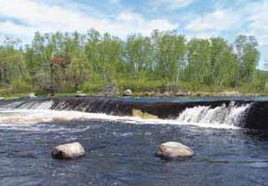
10 Lac du Bonnet 5 Pinawa Dam Provincial Park Pinawa 6 Whitemouth Falls Provincial Park 4 Natalie Lake Seven Sisters Whiteshell Provincial Park 307 Whiteshell Provincial Forest River Hills Kilometres Miles Legend Provincial Trunk Highways Provincial Roads Other Roads
11
12
13 Traverse Bay 11 Fort Alexander Catfish 7 Creek Wildlife Management Area Birding Sites 304 Lac du Bonnet McArthur Falls Great Falls Maple Creek Road St. Georges Powerview - Pine Falls Belair Provincial Forest Powerview - Pine Falls 6 St. Georges Kilometres Great Falls McArthur Falls 2 Lac du Bonnet Legend Provincial Trunk Highways Provincial Roads Other Roads Pinawa Miles Seven Sisters
14 Lake Winnipeg Grand Beach Grand Marais Hillside Beach Grand Beach Provincial Park Belair Belair Provincial Forest Traverse Bay Fort Alexander Catfish Creek Wildlife Management Area Kilometres Miles Legend Provincial Trunk Highways Stead Provincial Roads Other Roads
15
16 8 Legend Provincial Trunk Highways Provincial Roads Other Roads 27 Saint Andrews 9 Lockport Birds Hill Provincial Park East St. Paul 101 Winnipeg Birds Hill Kilometres Oakbank Miles
17
18
19 Kilometres Miles Gunton Petersfield Oak Hammock Marsh Wildlife Management Area Clandeboye Selkirk Stony Mountain Lockport Birding Sites Interpretive Centre Main Observation Mound Tall Grass Prairie 3 Artesian Spring Trail North Observation Mound Oak Bluff Oak Hammock Road Kilometres Miles Legend Provincial Trunk Highways Provincial Roads Other Roads

20 Poplarfield Chatfield Narcisse Wildlife Management Area 12 Narcisse Snake Dens Narcisse Kilometres Miles Legend Provincial Trunk Highways Provincial Roads Other Roads
21 234 Hecla- Grindstone Provincial Park 329 Riverton Sandy Bar 13 Legend Provincial Trunk Highways Provincial Roads Other Roads Lake Winnipeg Balaton Beach Kilometres Miles

22 Legend Provincial Trunk Highways Other Roads Gull 7 Harbour 5 6 Hecla-Grindstone Provincial Park Hecla Island 4 Hecla Village Lake Winnipeg Birding Sites Grassy Marsh Trails Black Wolf Trail Wildlife Viewing Tower Hecla Village Kilometres Miles West Quarry Trail Lighthouse Trail North Cliffs
23

24 Sandilands Provincial Forest Menisino 15 Spur Woods Wildlife Management Area Piney Legend Provincial Trunk Highways Provincial Roads Other Roads Kilometres Miles

25 Tall Grass Prairie Preserve Stuartburn Wildlife Management Area Roseau River Stuartburn Agassiz Trail 201 Vita Tolstoi Kilometres Miles Prairie Shore Trail 209 Gardenton Legend Birding Sites Provincial Trunk Highways Provincial Roads Other Roads

26 Rosa Rat River Wildlife Management Areas 17 Dufrost 23 St. Malo La Rochelle St. Malo Provincial Park Roseau River St. Malo Wildlife Management Areas Carlowrie 59 Rosa Stuartburn Kilometres Legend Provincial Trunk Highways Provincial Roads Kilometres Legend Provincial Trunk Highways Provincial Roads Miles Other Roads Miles Other Roads
27
28
29 Birding Sites 1 FortWhyte Alive 2 Living Prairie Museum 3 Assiniboine Park and Forest Mc Creary Rd Kilometres Miles 75 Legend Provincial Trunk Highways Provincial Roads Other Roads
30

31 Lake Manitoba Delta Beach Oakland Portage la Prairie High Bluff 331 St. Ambroise 430 Poplar Point Oakville Kilometres Miles Marquette Elie Fannystelle 2 Lake Francis Woodlands Warren 67 Grosse Isle Rosser St. Francois Xavier 424 Legend Birding Sites Provincial Trunk Highways Provincial Roads Other Roads

32 242 Westbourne 16 Delta Beach Oakland MacDonald Lake Manitoba St. Ambroise 22 Provincial Delta Marsh Park Wildlife Management Area Portage la Prairie Tin Town High Bluff Lake Francis Wildlife Management Area 227 St. Marks 26 St. Ambroise 430 Poplar Point Kilometres Miles 331 Legend Provincial Trunk Highways Provincial Roads Other Roads
33
34
35 TRANSCANADA TRAIL 504 VICTORIA BEACH LAKE 304 HILLSIDE BEACH WINNIPEG SAGKEENG FIRST NATION BELAIR POWERVIEW ST. GEORGES 12 BORDER to BEACHES FORT ALEXANDER 11 Grand Beach Provincial Park GRAND BEACH GRAND MARAIS 59 SILVER FALLS 500 GREAT FALLS 304 BEACONIA STEAD 11 TRAIL LEGEND 12 KM 313 BROKENHEAD FIRST NATION POINTE du BOIS Existing Trail Prior To B2B Trail Completed Trail Under Construction Trail Proposed Trail Proposed Trail Proposed LAC du BONNET 520 Pinawa Dam Provincial Park PINAWA Whitemouth Falls Provincial Park Trail Requiring Upgrading SEVEN SISTERS OntarioTrail Connection (?) North Star Trail Birds Hill Provincial Park WHITEMOUTH ELMA RENNIE WINNIPEG WEST HAWK FALCON LAKE First Nations Provincial Parks Rural Municipal Boundaries SHOAL LAKE FIRST NATION #40 SHOAL LAKE FIRST NATION #39A Kilometres MAPS PRODUCED BY WOODRIDGE MAPPING SERVICES " # ( %! ) #! # ( " # ) 2! > /! 0 / #! +# ) * " 1 # & 2 ' ( / 2 "
36
37
38
39
40
41
42 Manitoba's Pine To Prairie Birding Trail Winnipeg - Manitoba Locations 1 Buffalo Point First Nation 2 Moose Lake and Birch Point Provincial Parks 3 Whiteshell Provincial Park 4 Whitemouth Falls Provincial Park 5 Pinawa Dam Provincial Park 6 Pinawa 7 Winnipeg River to Traverse Bay (Highway 11) 8 Grand Beach Provincial Park 9 Birds Hill Provincial Park 10 Lockport 11 Oak Hammock Marsh Wildlife Management Area 12 Narcisse Wildlife Management Area and Snake Dens 13 Sandy Bar 14 Hecla-Grindstone Provincial Park 15 Spur Woods Wildlife Management Area 16 Tall Grass Prairie Preserve 17 Rat River Wildlife Management Area 18 St. Malo Wildlife Management Area 19 St. Malo Provincial Park FortWhyte Alive Living Prairie Museum Assiniboine Park and Forest St. Francois Xavier to Portage la Prairie (Highway 26) St. Ambroise Provincial Park Delta Marsh Wildlife Management Area Minnesota's Pine To Prairie Birding Trail 30 Felton Prairie 33 Pelican Rapids City Parks 34 Maplewood State Park 40 Fergus Falls Lake Alice 44 Glendalough State Park Minnesota Locations 1 Warroad Point Park 2 Lost River State Forest 3 Roseau Waste Water Treatment Ponds 4 Roseau River Wildlife Management Area 5 Beltrami Island State Forest 6 Red Lake Wildlife Management Area 7 Hayes Lake State Park 8 The Wallace C. Dayton Conservation and Wildlife Area 9 Lake Bronson State Park 10 Twin Lakes Wildlife Management Area 11 Thief Lake Wildlife Management Area 12 Agassiz National Wildlife Refuge 13 Old Mill State Park 14 Wetlands, Pines and Prairie Audubon Sanctuary 15 Thief River Falls Waste Water Treatment Ponds 16 Gully Rice Paddies / Gully Fen Scientific and Natural Area 17 Pembina Trail Preserve Scientific and Natural Area 18 Pankratz Memorial Prairie 19 Tympanuchus Wildlife Management Area 20 Burnham Creek Wildlife Management Area 21 Glacial Ridge National Wildlife Refuge 22 Rydell National Wildlife Refuge 23 Agassiz Dunes Scientific and Natural Area Agassiz Environmental Learning Center 24 Waubun Wildlife Management Area 25 Helliksen Prairie Waterfowl Production Area 26 Hamden Slough National Wildlife Refuge 27 Tamarac National Wildlife Refuge 28 Detroit Lakes Wetlands Management District 29 Dunton Locks County Park 31 Buffalo River State Park / Regional Science Center 32 Bluestem Prairie Scientific and Natural Area 35 Anna Gronseth Prairie / Town Hall Prairie 36 Rothsay Wildlife Management Area 37 Kettledrummer Prairie / Foxhome Prairie 38 Breckenridge Waste Water Treatment Ponds 39 Prairie Wetlands Learning Center 41 Fergus Falls Riverview Waterfowl Sanctuary 42 Agassiz Waterfowl Production Area 43 Orwell Wildlife Management Area 45 Egret Island Scientific and Natural Area (Pelican Lake)

43 MANITOBA LEGEND MAIN BIRDING TRAIL SITE LOCATION HECLA 8 ALTERNATE BIRDING TRAIL SITE LOCATION RIVERTON CITY/TOWN NARCISSE 11 8 PINE FALLS/POWERVIEW GRAND BEACH ST. AMBROISE 23 DELTA MARSH 11 4 LOCKPORT 26 PORTAGE la PRAIRIE 21 ST. FRANCIS XAVIER LAC du BONNET 7 9 PINAWA 6 SEVEN SISTERS WINNIPEG RENNIE 44 FALCON LAKE 59 ST. MALO Kilometres TOLSTOI SPRAGUE ROSEAU WARROAD THIEF RIVER FALLS 14 MINNESOTA LEGEND SITE LOCATION BIRDING TRAIL WINGER FERTILE CITY/TOWN DETROIT LAKES PELICAN RAPIDS /41 FERGUS FALLS MANITOBA Miles MINNESOTA 50
44
Black Island Hecla/Grindstone Provincial Park. Aghaming. Seymourville. Hollow Water First Nation. Manigotagan. Observation Point
 Study Moose Creek 105 W Management 100 W Area 95 W 90 W 60 N Lee Lake agement Area 55 N Washow Bay Shorncliffe UV 234 Manitoba 55 N Hecla Black Island Hecla/Grindstone Aghaming Seymourville Hollow Water
Public Review on Proposed Changes to Trapping Policy
 Public Review on Proposed Changes to Trapping Policy in Manitoba s Provincial Parks and Other Crown Lands With Recreational Developments In December 2012, two dogs were killed in traps while they were
Public Water System Compliance with Provincial Physical, Chemical, and Microbial Standards - Seasonal Systems
 Upgrades, ALBERT BEACH TRAINOR SUBDIVISION 150 Well Private NR NR NR NR NR
2018 SPRING ROAD RESTRICTIONS (SRR) ORDER # 1 RESPECTING THE OPERATION OF VEHICLES ON HIGHWAYS IN THE PROVINCE OF MANITOBA
 ORDER # 1 RESPECTING THE OPERATION OF VEHICLES ON HIGHWAYS IN THE PROVINCE OF MANITOBA") 2018 SPRING ROAD RESTRICTIONS (SRR) ORDER # 1 RESPECTING THE OPERATION OF VEHICLES ON HIGHWAYS IN THE PROVINCE OF MANITOBA Pursuant to subsections 86(1), 86(2) and 86(3), The Highway Traffic Act (C.C.S.M.
2018 SPRING ROAD RESTRICTIONS (SRR) ORDER # 1 RESPECTING THE OPERATION OF VEHICLES ON HIGHWAYS IN THE PROVINCE OF MANITOBA Pursuant to subsections 86(1), 86(2) and 86(3), The Highway Traffic Act (C.C.S.M.
MANITOBA PROTECTED AREAS CHART
 MANITOBA PROTECTED AREAS CHART Manitoba Wildlands February 2011 Name of Protected Area (listed by type) Ecological Reserves Armit Meadows Ecological Reserve Baralzon Lake Ecological Reserve Birch River
Provincial Water Advisories Rescinded Since 2000
 Since 2000 1 03-Jul-09 22-Jun-09 Interlake Camp Neustadt Gimli, RM of 2 26-Jun-09 11-Jun-09 Burntwood & Churchill Lynn Lake - PWS Town of Lynn Lake 3 08-Jun-09 27-May-09 Norman Lynn Lake Lynn Lake 4 15-May-09
Bridges and Structures
 Bridges and Structures Commitment: $2. million over five years Manitoba Infrastructure and Transportation has a five-year plan to invest $2 billion in Manitoba s road system. Of this, $.2 billion is for
Neso Lake. Classification: Landscape Description: Park Purpose: Recreation Park
 Neso Lake Classification: Recreation Park Landscape Description: This small recreation park provides access to Neso Lake and the Mistik Creek canoe route. It is located in the Churchill River Upland portion
Powerview-Pine Falls. Pine. Falls G.S. Mas k wa ST 304. Brightstone Sand Hills P.F. Thalberg Bush WMA ST Lac du Bonnet.
 2 Teulon 4 4 Bri Stonewall ST gh ts to n e So u th 4 5 Bri gh ts to n e File Location: U: \Project s\55402_pointedubois_spillway_replacement\arc0\mxd\pointe _TECHREP_P rotectedareas_400k_b_draft.mxd ST
Seniors Housing Interlake-Eastern Regional Health Authority
 Seniors Interlake-Eastern Regional Health Authority Disclaimer: The Seniors and Healthy Aging Branch created this directory as a public service in response to older adults and families requests for information.
Major Parks. Ada. Argyle. Crookston. East Grand Forks. Malmberg Prairie. Game Refuges. Lockhart Swamp. Pankratz Memorial Prairie
 Lockhart Swamp Ada 10 mi. N and 6.5 mi. E of Ada on Co. Rd 5. Old Mill State Park Argyle 218-847-1579 33489 240th Ave. NW 17 mi. NE of Warren, or 13 miles E of Argyle or 11 miles W of Newfolden on County
The dialling plan for the area served by NPA Codes 204 and 431 will be as follows:
 Number: PL- 419 Date: May 6, 2011 From: Canadian Numbering Administrator (CNA) Subject: NPA 431 to Overlay NPA 204 (Manitoba, Canada) Related Previous Planning Letters: None In Telecom Decision CRTC 2010-526
$1 Million+ Lottery Winners in Manitoba As of June 29, 2017 AMOUNT GAME DRAW CITY. $ 50,000, LOTTO MAX November 6, 2009 Sagkeeng First Nation
 As of June 29, 2017 AMOUNT GAME DRAW CITY DATE $ 50,000,000.00 LOTTO MAX November 6, 2009 Sagkeeng First Nation $ 27,227,325.00 LOTTO 6/49 November 12, 2005 Winnipeg $ 19,899,826.30 SUPER 7 December 14,
Segment 2: La Crescent to Miller s Corner
 goal of the USFWS refuges is to conserve, protect and enhance fish, wildlife and plants and their habitats for the continuing benefit of the American people. Refuge lands are used largely for fishing,
January Sunday Monday Tuesday Wednesday Thursday Friday Saturday
 January 2012 1 2 Day Observed New Year s Day 3 4 5 6 7 8 9 10 11 12 13 14 15 16 17 18 19 20 21 22 23 24 25 7:00 p.m. Water and Sewer Gimli 26 27 28 29 30 31 Unless otherwise noted, hearings will be held
Seddons. Corner. Molson. Whitemouth. Vivian Ste. Rita [\ 15. Ross Ste-Geneviève. Hadashville. Richer M602F BOREAL SHIELD ECOZONE. Marchand. St.
 [\ 8 [\ 9 Stonewall [\ 67 Gosse Isle Stony Mountain Beausejou Seddons Cone Molson [\ 26 Dosey Rosse Headingley City of Assiniboine Rive Oakbank Riel Deacons Cone Hazelidge Dugald Glass Cooks Ceek Cloveleaf
Protected Areas Manitoba Chronology
 Protected Areas Manitoba Chronology 1990-2010 At a minimum, protected areas prohibit, through legal means, logging, mining (including aggregate extraction), and oil, petroleum, natural gas or hydro-electric
Whitemouth Falls Provincial Park. Draft Management Plan
 Whitemouth Falls Provincial Park Draft Management Plan Whitemouth Falls Provincial Park Draft Management Plan Table of Contents 1. Introduction... 3 2. Park History... 3 3. Park Attributes... 4 3.1 Natural...
Alberta Carsland Bow River Headworks System Brochure
 Location / Folder Title Description/Publisher Type Year Alberta Alberta's parks and protected areas Booklet 2000 Alberta Slave River Feasibility Study Newsprint Report Alberta Slave River Feasibility Study
Tenders. Manitoba Infrastructure
 Tenders Manitoba Heavy Construction Association Unit 3-1680 Ellice Ave. Winnipeg, MB R3H 0Z2 Tel: (204) 947-1379 Fax: (204) 943-2279 www.mhca.mb.ca Email: jocelyn@mhca.mb.ca Manitoba Infrastructure Reference
Pinawa Provincial Park. Draft Management Plan
 Pinawa Provincial Park Draft Management Plan Pinawa Provincial Park Draft Management Plan Table of Contents 1. Introduction... 3 2. Park History... 3 3. Park Attributes... 4 3.1 Natural... 4 3.2 Recreational...
DISTRIBUTION OF STUDENTS FIRST ADMITTED FROM MANITOBA HIGH SCHOOLS 1 Regular Session
 DISTRIBUTION OF STUDENTS FIRST ADMITTED FROM MANITOBA HIGH SCHOOLS 1 Regular Session 2003-2004 SCHOOL FULL PART DIVISION SCHOOL FULL PART DIVISION Public High Schools Winnipeg Birtle 4 0 Park West Aboriginal
ORGANIZATIONS FUNDED IN 2018 (rural Manitoba - sorted by region) ORGANISATIONS FINANCÉES EN 2018 (régions rurales du Manitoba - classées par régions)
 ORGANISATIONS FINANCÉES EN 2018 (régions rurales du Manitoba - classées par régions)") ORGANIZATIONS FUNDED IN 2018 (rural Manitoba - sorted by region) ORGANISATIONS FINANCÉES EN 2018 (régions rurales du Manitoba - classées par régions) Central A Rocha Canada Border Land School Division
ORGANIZATIONS FUNDED IN 2018 (rural Manitoba - sorted by region) ORGANISATIONS FINANCÉES EN 2018 (régions rurales du Manitoba - classées par régions) Central A Rocha Canada Border Land School Division
Manitoba Bureau of Statistics
 Province of Manitoba Manitoba Bureau of Statistics Manitoba Bureau of Statistics Manitoba Population and Dwelling s Statistics Canada has released the population and dwelling counts from the May of the
TransCanada PipeLines Limited Section 58 Application Emerson Extension Delivery Point Reconnections Attachment 6. Survey and Access Maps
 Section 58 pplication ttachment 6 Survey and ccess Maps RGE 4 RGE 5 Dufrost Ste Elizabeth St Malo Saint Malo Sales 216 St Jean 200 Baptiste Carlowrie rnaud 217 Barkfield Morris 218 218 Halbstadt 7 1-4-EPM
IOWA ORNITHOLOGISTS' UNION - Birding Sites in Dallas County
 IOWA ORNITHOLOGISTS' UNION - Birding Sites in Dallas County Printed on 7/19/2018 Beaver Bottoms Wetland (restricted) (Important Bird Area) GPS Coordinates:, Ownership: Private (see directions for access)
Criddle/Vane Homestead
 Heritage Parks Criddle/Vane Homestead contains the first entomology laboratory in western Canada. The last family members left the homestead in 1960. The park features building and structural remnants
Sasagiu Rapids Provincial Park. Draft Management Plan
 Sasagiu Rapids Provincial Park Draft Management Plan 2 Sasagiu Rapids Provincial Park Table of Contents 1. Introduction... 3 2. Background and Park Attributes... 3 2.1 Park History.... 3 2.2 Natural Features...
APPENDIX 19-II. Ontario Trail Network Trailheads EAST-WEST TIE TRANSMISSION PROJECT AMENDED ENVIRONMENTAL ASSESSMENT REPORT
 EAST-WEST TIE TRANSMISSION PROJECT AMENDED ENVIRONMENTAL ASSESSMENT REPORT APPENDIX 19-II Ontario Network heads Report. 1536607/2000/2219 Ontario Network heads in the n-commercial Land and Resource Use
Photography Guide U.P. of Michigan
 Photography Guide U.P. of Michigan Porcupine Mountains Pictured Rocks National Seashore & Tahquamenon Falls By Bill Welch The U.P. of Michigan Michigan s Upper Peninsula (the U.P.) is a forest covered
Birch Point Provincial Park. Management Plan
 Birch Point Provincial Park Management Plan 2 Birch Point Provincial Park Table of Contents 1. Introduction... 3 2. Park History... 3 3. Park Attributes... 4 3.1 Natural... 4 3.2 Recreational... 4 4. Park
SOUTH SECTION TRAIL SITES as of Mon Oct
 SOUTH SECTION TRAIL SITES as of Mon Oct. 16 2017 Partial Site is open but some hiking trails/facilities may be closed Closed Site is closed until further notice Open Site is open Unknown We have no information
MANITOBA PROVINCIAL PARKS THE 2010 SEASONAL CAMPER S GUIDE
 MANITOBA PROVINCIAL PARKS THE 2010 SEASONAL CAMPER S GUIDE Manitoba's Provincial Parks offer you the enjoyment of outdoor living and an opportunity to be close to nature with your family and friends. Manitoba
Atikaki. Established: Classification: Landscape Description: Park Purpose: July 18, Wilderness Park
 Wilderness Parks Atikaki Established: July 18, 1985 Classification: Wilderness Park Landscape Description: Total park area is 3,981 km 2, characterized by a landscape of rock outcrops and granite cliffs
THE ISLANDS PROVINCIAL PARK
 THE ISLANDS PROVINCIAL PARK Situated at the mouth of the Roseway River on Nova Scotia s scenic South Shore, The Islands is located across the harbour from the historic town of Shelburne. The park s picturesque
Location Photography 13
 13 Location Photography CONTEMPORARY WINNIPEG 1 2 3 4 14 CONTEMPORARY WINNIPEG 5 6 7 8 9 10 11 15 CONTEMPORARY WINNIPEG 12 13 14 15 16 CONTEMPORARY WINNIPEG 16 17 EXCHANGE DISTRICT, DOWNTOWN 18 17 19 20
INDIAN AGENCIES, RESERVES AND BANDS FOR THE PROVINCE OF SASKATCHEWAN. List A - Indian Reserves in alphabetical order
 .INDIAN AFFAIRS AND NORTHERN DEVELOPMENT LIBRARY SJBUQTHEQUE DES AFFAIRES INDIENNES ET DU NORD CANADIEN v-* INDIAN AGENCIES, RESERVES AND BANDS FOR THE PROVINCE OF SASKATCHEWAN List A - Indian Reserves
2012 Seasonal Camping
 Parks & Natural Areas www.manitobaparks.com 2012 Seasonal Camping We are pleased to be able to provide you with a copy of the 2012 Seasonal Camping Package, including an updated Seasonal Camper s Guide
Heritage Grants Program 2016/2017 January Intake - Grant Approvals
 Heritage Grants Program 2016/2017 January Intake - Grant Approvals CENTRAL Boundary Trail Heritage Region Incorporated The Heritage Landscape of the Boundary Trail Heritage Region Phase II South Central
gpp architcture inc. Saint-Georges Community Development Corporation Société de développement communautaire de Saint-Georges
 Prepared by: Pré pa ré pa r: Prepared for: Pr ép ar é pou r: gpp architcture inc. Saint-Georges Community Development Corporation Société de développement communautaire de Saint-Georges Guy Préfontaine
Appendix J: National and State Airport Classifications
 Appendix : National and State Airport Classifications The National Plan of Integrated Airports (NPIAS) is constantly updated as state and local airport and system plans are completed and accepted by the
PORTAGE LA PRAIRIE, CITY R.M. of Portage la Prairie Special Places
 Culture Heritage & Tourism CENTRAL Portage and District Heritage Advisory PORTAGE LA PRAIRIE, CITY R.M. of Portage la Prairie Special Places $5,337.00 Portage la Prairie Municipal Heritage Advisory PORTAGE
Watchorn Provincial Park. Management Plan
 Watchorn Provincial Park Management Plan 2 Watchorn Provincial Park Table of Contents 1. Introduction... 3 2. Park History... 3 3. Park Attributes... 3 3.1 Natural... 4 3.2 Recreational... 4 3.3 Additional
Cottager. Cottager. mission statement
 mission statement Since 1992 magazine has delivered a beautifully crafted, glossy magazine that gets right to the heart of cottage living. We talk about everything from building and renovating to fishing,
SNAPSHOT Investing in Roads and Bridges 2016 Budget for a Better Minnesota
 SNAPSHOT Investing in Roads and Bridges 2016 Budget for a Better Minnesota Modern roads, bridges, and transit are the foundation of an economy that works for all Minnesotans everywhere in Minnesota. Our
Members of the Wetland Ecology 2010 class:
 Members of the Wetland Ecology 2010 class: Attached is an information package that describes the class this year, including a draft copy of the course outline and some information on the Delta Marsh Field
2.1 Physical and Biological Description Matabitchuan River Watershed
 2.1 Physical and Biological Description Watershed 2.1.1 Physical Description The system watershed has a total area of about 933 km 2 and is a tributary system to Lake Temiskaming and the Ottawa River Drainage
n e w s r e l e a s e
 n e w s r e l e a s e FOR IMMEDIATE RELEASE September 23, 2011 Advance voting opens tomorrow More opportunities than ever to vote in advance More advance voting locations and an additional day of advance
Approved Raffle Licences
 Approved Raffle s With Dates From January 1, 2018 Current as of: April 16, 2018 Lic # Organization Name Org Final Prize Value 3945 Minnedosa Golf & Country Club Minnedosa 07/26/2016 01/02/2018 Minnedosa
STATE OF MINNESOTA DEPARTMENT OF NATURAL RESOURCES
 STATE OF MINNESOTA DEPARTMENT OF NATURAL RESOURCES Pursuant to Minnesota Statutes, Section 105.391, Subd.1, the Commissioner of Natural Resources hereby publishes the final inventory of Protected (i.e.
Level IV Ecoregions of the Northeast Glacial Lakes Watershed Project Area
 Level IV Ecoregions of the Northeast Glacial Lakes Watershed Project Area Ecoregions are areas having similar ecosystems and environmental resources including geology, physiography, vegetation, climate,
Wallace Lake Provincial Park. Draft Management Plan
 Wallace Lake Provincial Park Draft Management Plan Wallace Lake Provincial Park Draft Management Plan Table of Contents 1. Introduction... 3 2. Park History... 3 3. Park Attributes... 4 3.1 Natural...
COMMUNITY DEVELOPMENT PROJECTS. The following projects are receiving funding from the Neighbourhoods Alive! program:
 COMMUNITY DEVELOPMENT PROJECTS The following projects are receiving funding from the Neighbourhoods Alive! program: Applicant Location Project Funding Mealshare Aid Foundation Tackling Youth Hunger in
IOWA ORNITHOLOGISTS' UNION - Birding Sites in Linn County
 IOWA ORNITHOLOGISTS' UNION - Birding Sites in Linn County Printed on 6/15/2018 Bever Park (ebird Hotspot) GPS Coordinates: 41.9851219,-91.6269125 Restrooms Parking Trails ADA Accessible Trails Boyson Trail
Happening every Saturday between June 3 and September 30, 2017 From 9:00am-2:00pm Bronx Park Community Centre Contact:
 Winnipeg Markets, Festivals, and Meals Le Marche St. Norbert Farmers Market Happening every Saturday between May 20 th and October 28 th, 2017 From 8:00am-3:00pm Le Marche St. Norbert Farmers Market Contact:
(/ 12 (/ 18 (/ 18 (/ 12 (/ 51 (/ 14 Æ%106 Æ% 106 Æ% 213 Æ% 104 Æ% 89 Æ% 26 Æ% 73 Æ% 59 Æ% 138 Æ% 92 Æ% 26 Æ% 67 Æ% 11 Æ% 11 Æ% 11. Æÿ H Æÿ Z.
 WAUKESHA Existing Ice Age Trail, subject to change as it evolves toward completion Glacial Drumlin Rail-Trail 94 Ice Age Trail Rock, Walworth and Jefferson Counties Other Trail Unofficial Connecting Route
Green Legacy. Securing our. Greenlands Strategy
 Greenlands Strategy Securing our Green Legacy Together we can create an interconnected network of Greenlands for the health and well-being of the environment and future generations Caring for the Credit
Multi-purpose Trails 22 NORTHWEST MINNESOTA VISITOR & RECREATION GUIDE. Pine to Prairie Birding Trail. Red River/Pembina Oxcart Trail
 1-800-433-1888 http://www.mnbirdtrail.com/ Throughout all of region 43 stops available. Kittson county part of trail goes through the Twin Lakes Wildlife Area. A unique collection of habitats in Northwestern
Broward County Land Use Plan: Environmentally Sensitive Lands
 US27 HIATUS RD NW 136TH AVE SW 136TH AVE FLAMINGO RD LYONS RD CYPRESS RD Broward County Land Use Plan: Environmentally Sensitive Lands PALM BEACH COUNTY N USHY 27 284939 334939 045039 095039 44 CONSERVATION
Segment 4: Hokah to Mound Prairie
 Root River Wildlife Management Area The main unit of this WMA is located just north of the Root River and the city of Hokah. Its 443 acres include mixed hardwoods of oak, basswood, ash, cottonwood, elm
South Atikaki Provincial Park. Draft Management Plan
 South Atikaki Provincial Park Draft Management Plan South Atikaki Provincial Park Draft Management Plan Table of Contents 1. Introduction... 3 2. Park History... 3 3. Park Attributes... 3 3.1 Natural...
Manitoba Regional Health Authority (RHA) DISTRICTS MCHP Area Definitions for the period 2002 to 2012
 DISTRICTS MCHP Area Definitions for the period 2002 to 2012") The following list identifies the RHAs and RHA Districts in Manitoba between the period 2002 and 2012. The 11 RHAs are listed using major headings with numbers and include the MCHP - Manitoba Health codes
The following list identifies the RHAs and RHA Districts in Manitoba between the period 2002 and 2012. The 11 RHAs are listed using major headings with numbers and include the MCHP - Manitoba Health codes
Pembina Valley Provincial Park. Draft Management Plan
 Pembina Valley Provincial Park Draft Management Plan 2 Pembina Valley Provincial Park Table of Contents 1. Introduction... 3 2. Park History... 3 3. Park Attributes... 3 3.1 Natural... 3 3.2 Recreational...
DAKOTA CULTURE UPPER SIOUX COMMUNITY: AREA CHARACTER ANALYSIS ALIGNMENT STRATEGY
 UPPER SIOUX COMMUNITY: AREA CHARACTER ANALYSIS ALIGNMENT STRATEGY 51 AREA CHARACTER ANALYSIS: OPPORTUNITIES & CONSTRAINTS RECREATIONAL VEHICLE PARK: A recreational vehicle park will be built to accommodate
Wallace Lake Provincial Park. Management Plan
 Wallace Lake Provincial Park Management Plan 2 Wallace Lake Provincial Park Table of Contents 1. Introduction... 3 2. Park History... 3 3. Park Attributes... 4 3.1 Natural... 4 3.2 Recreational... 4 4.
Manitoba DIRECT SERVICE POINTS
 Alexander MB3 $750 Yes Altamont MB3 $4000 Yes Altona MB3 Yes Anola MB3 $750 Yes Arborg MB3 $750 Yes Arden MB3 $4000 Yes Argyle MB3 $750 Yes Arnaud MB3 $2000 Yes Arnes MB3 $2000 Yes Arrow River MB3 $5000
Norris Lake Provincial Park. Draft Management Plan
 Norris Lake Provincial Park Draft Management Plan 2 Norris Lake Provincial Park Table of Contents 1. Introduction... 3 2. Park History... 3 3. Park Attributes... 4 3.1 Natural... 4 3.2 Recreational...
Portage Spillway Provincial Park. Draft Management Plan
 Portage Spillway Provincial Park Draft Management Plan 2 Portage Spillway Provincial Park Table of Contents 1. Introduction... 3 2. Park History... 3 3. Park Attributes... 4 3.1 Natural... 4 3.2 Recreational...
T R I P G U I D E
 2018 TRIP GUIDE ABOUT US OUR TRIPS TAKE IN THE MOST BEAUTIFUL AND WILD CORNERS OF MANITOBA We re a Manitoba travel company founded to help people enjoy unique travel experiences and opportunities. We
Delaware Wildlife Area
 Delaware Wildlife Area 8 miles away from Delaware 4,670 acre Wildlife Area 1) Take Rt. 36/East Williams Street eastward 2) Take left onto Rt. 42/Lake Street 3) Slight left onto Horseshoe Rd./CR. 220 4)
THE FLORIDA TRAIL ASSOCIATION. Congressional Report. Trail Operations Report
 THE FLORIDA TRAIL ASSOCIATION Congressional Report 2017 Trail Operations Report 1 Like on Facebook: facebook.com/floridatrailassociation Follow on Twitter: twitter.com/floridatrail See on Instagram: instagram.com/floridatrail
Manitoba DIRECT SERVICE POINTS
 Alexander MB3 $750 Yes Altamont MB3 $6000 Yes Altona MB3 Yes Anola MB3 $750 Yes Arborg MB3 $750 Yes Arden MB3 $6000 Yes Argyle MB3 $750 Yes Arnaud MB3 $750 Yes Arnes MB3 $750 Yes Arrow River MB3 $7000
306 Ice Age Trail Guidebook : 200,000 compilation scale. February 3, Marsh. Glenbeulah. Greenbush. Sheboygan. Parnell. Segment.
 G MANITOWOC Existing Ice Age Trail, subject to change as it evolves toward completion FOND DU LAC Other Trail Unofficial Connecting Route (unmarked) County Boundary ublic or IATA Land Miles 0 1 2 3 4 Marsh
IOWA ORNITHOLOGISTS' UNION - Birding Sites in Cerro Gordo County
 IOWA ORNITHOLOGISTS' UNION - Birding Sites in Cerro Gordo County Printed on 11/17/2018 Blue-wing Marsh GPS Coordinates: 43.0834956379463,-93.4430980682373 Pure natural area primarily used for hunting.
proof Northwest District
 1 Northwest District The Northwest Florida Water Management District is the most rural of all five water management districts. From just east of Tallahassee west to the Florida/Alabama line, and from the
Rail Trail Walking Challenge!
 Included with these routes is the Municipality of the District of Lunenburg s trail brochure. This map gives a rough estimate of the locations of our 6 rail trails, all managed by volunteer associations!
Seager Wheeler Lake. Representative Area. -- Concept Management Plan --
 Seager Wheeler Lake Representative Area -- Concept Management Plan -- Saskatchewan Environment and Resource Management January, 1999 Saskatchewan s Representative Areas Network Program The Government of
Locations. Emerson Morris Sainte Agathe Saint Adolphe Saint Norbert Winnipeg (The Forks) St. Andrews Lockport Selkirk Netley Creek
 St. Andrews Lockport Selkirk Netley Creek") Locations Emerson Morris Sainte Agathe Saint Adolphe Saint Norbert Winnipeg (The Forks) St. Andrews Lockport Selkirk Netley Creek The water in the Red River has a tendency to fluctuate and even to flood
Locations Emerson Morris Sainte Agathe Saint Adolphe Saint Norbert Winnipeg (The Forks) St. Andrews Lockport Selkirk Netley Creek The water in the Red River has a tendency to fluctuate and even to flood
This document is made available electronically by the Minnesota Legislative Reference Library as part of an ongoing digital archiving project.
 This document is made available electronically by the Minnesota Legislative Reference Library as part of an ongoing digital archiving project. http://www.leg.state.mn.us/lrl/lrl.asp (Funding for document
SITE SELECTORS INFORMATION
 SITE SELECTORS INFORMATION Location Morden is located in South Central Manitoba, 112 km from Winnipeg City Limits, 19 km from the U.S. border, 127 km from the Winnipeg International Airport. The exact
Back to the Land. A Genealogical Guide to Finding Farms on the Canadian Prairies. Including an index to townships in the 1901 census
 A Genealogical Guide to Finding Farms on the Canadian Prairies Including an index to townships in the 1901 census Compiled by Dave Obee Second edition A Genealogical Guide to Finding Farms on the Canadian
V I S I T O R S G U I DE 2 018
 VISITOR S GUIDE 2018 WELCOME TO MANITOBA PARKS. As Minister of Sustainable Development, I am pleased to welcome you to Manitoba s provincial parks, where the great outdoors provides a memorable environment
Recreation in the Battle River Basin: Overview. John Thompson, Watrecon Consulting
 Recreation in the Battle River Basin: Overview John Thompson, Watrecon Consulting Recreation Rates for Alberta & Battle Basin Households 1996 2004 Battle Basin Alberta Battle Basin Alberta Bird Watching
Split Rock 100th anniversary. Superior Point Light. Eagle Harbor Lighthouse. Marquette Harbor Lightouse. Grand Island Lighthouse(before)
") Split Rock 100th anniversary Split Rock Lighthouse Duluth Entry Lights Superior Point Light Two Harbors Lighthouse Eagle Harbor Lighthouse History Eagle Harbor Lighthouse Eagle Harbor Lighthouse 2 Ontonagon
Split Rock 100th anniversary Split Rock Lighthouse Duluth Entry Lights Superior Point Light Two Harbors Lighthouse Eagle Harbor Lighthouse History Eagle Harbor Lighthouse Eagle Harbor Lighthouse 2 Ontonagon
SITE SELECTORS INFORMATION
 SITE SELECTORS INFORMATION Location Morden is located in South Central Manitoba, 112 km from Winnipeg City Limits, 19 km from the U.S. border, 127 km from the Winnipeg International Airport. The exact
WEST SECTION TRAIL SITES as of Mon October
 WEST SECTION TRAIL SITES as of Mon October 9 2017 Partial Site is open but some hiking trails/facilities may be closed Closed Site is closed until further notice Open Site is open Unknown We have no information
Prepared by Cathy Quinlan & Brad Hertner Upper Thames River Conservation Authority. For the City of Woodstock
 Prepared by Cathy Quinlan & Brad Hertner Upper Thames River Conservation Authority For the City of Woodstock Burgess Park and Standard Tube Parks in the west end of Woodstock Pittock Reservoir Along the
STATE OF MINNESOTA DEPARTMENT OF NATURAL RESOURCES
 STATE OF MINNESOTA DEPARTMENT OF NATURAL RESOURCES Pursuant to Minnesota Statutes, Section 105.391, Subd. 1, the Commissioner of Natural Resources hereby publishes the final inventory of Protected (i.e.
Alltel Communications, LLC 2000 Technology Drive. Senior Counsel office mobile fax.
 Alltel Communications, LLC 2000 Technology Drive Mankato, MN 56001 Sean Simpson Senior Counsel 507-385-2455 office 507-327-2455 mobile 507-385-2200 fax February 6,2008 Mr. Burl Ham Executive Secretary
GST/HST Incremental Federal Rebate for Municipalities Report - January 1, 2017 to December 31, 2017
 2625360 MANITOBA ASSOCIATION INC. NEEPAWA R0J $773.94 285 PEMBINA INC. WINNIPEG R2K $13,044.03 4508841 MANITOBA ASSOCIATION INC. WINNIPEG R2K $1,487.42 474 HARGRAVE CORPORATION WINNIPEG R3A $2,182.39 6869166
STORNETTA BROTHERS COASTAL RANCH
 STORNETTA BROTHERS COASTAL RANCH Location: Surrounding Point Arena Lighthouse and immediately south of Manchester State Park Mendocino Co., CA Acres: 1,860 Resources: Over two miles of Pacific Ocean coastline
Valid Petroleum Permits as of April 14, 2011
 Permit # Business Name Expiry Date Municipality Type of Facility 20777 STONEY'S PLACE 30 Apr 11 Deloraine U/G 20598 H & L MOTORS 30 Apr 11 Glenboro A/G 20597 H & L MOTORS 30 Apr 11 Glenboro U/G 21919 FIVE
Cross-sections involving a location within Manitoba and a location outside Manitoba:
 Bell MTS SUPPLEMETARY TARIFF CRTC 24002 SPECIAL SERVICES AD FACILITIES 9th Revised Page 149 Cancels 8th Revised Page 149 ITEGRATED DIGITAL ETWORK SERVICES 6016 FORBEARACE OF ITER-EXCHAGE PRIVATE LIE SERVICES
Milwaukee River (Washington County) Segment. Kewaskum. Æÿ B. Æÿ D Southern. Kewaskum. Segment.
 Segment. Kewaskum. Æÿ B. Æÿ D Southern. Kewaskum. Segment.") Ice Age Trail Washington County Washington County FOND DU LAC WASHINGTON Æ% 28 Æÿ H Milwaukee River (Washington County) Æÿ B Æÿ S State Forest Northern Kettle Moraine Æÿ H Æ% 28 Ice Age Trail Alliance
Ice Age Trail Washington County Washington County FOND DU LAC WASHINGTON Æ% 28 Æÿ H Milwaukee River (Washington County) Æÿ B Æÿ S State Forest Northern Kettle Moraine Æÿ H Æ% 28 Ice Age Trail Alliance
Bratt ") 4. % F l o r i d a D e s i g n a t e d P a d d l i n g T r a i l s ") 164 «97 ") 99. Barrineau Park. M a p 1. M a p 2.
 4. % F l o r i d a D e s i g n a t e d P a d d l i n g T r a i l s ) 164 «97 ) 99. Barrineau Park. M a p 1. M a p 2.") F l o r i d a D e s i g n a t e d P a d d l i n g T r a i l s Bratt ") 4 Bluff Springs «4 Jay ") P e r d i d o R i v e r P e r d i d o CR R99A i v Walnut e r Hill ") 164 ") 97A «89 «97 ") 197 Barrineau
F l o r i d a D e s i g n a t e d P a d d l i n g T r a i l s Bratt ") 4 Bluff Springs «4 Jay ") P e r d i d o R i v e r P e r d i d o CR R99A i v Walnut e r Hill ") 164 ") 97A «89 «97 ") 197 Barrineau
Mille Lacs Moraine SNA Approach
 Approach Tower Road N46 16.636 W93 51.289 N46 16.491 W93 51.285 s Parking N46 16.329 W93 51.265 Approach Tower Road N46 16.636 W93 51.289 N46 16.491 W93 51.285 s Parking N46 16.329 W93 51.265 Borden s
Bon Portage Island Conservation Campaign
 Bon Portage Island Conservation Campaign Protecting a Coastal Treasure Final Report to Nova Scotia Habitat Conservation Fund September 2012 Protection of Bon Portage Island Over the course of this two-year
Sunday - Wisconsin Creek
 2015 I Heart Wisconsin River Trip State Natural Area Boat landings people could meet me Ruth Oppedahl Help needed Campsite or lodging ruth@oppedahl.com Bird City/Important Bird Area (IBA) Dams/portages
Clearwater Lake Provincial Park. Draft Management Plan
 Clearwater Lake Provincial Park Draft Management Plan Clearwater Lake Provincial Park Draft Management Plan Table of Contents 1. Introduction... 3 2. Park History... 4 3. Park Attributes... 4 3.1 Location/Access...4
BIRDING Lake Fayetteville
 BIRDING Lake Fayetteville Lake Fayetteville is an impoundment of Clear Creek, created as a water supply for Fayetteville in 1949. With development of other water supplies, especially Beaver Lake, Lake