East Carson River Strategy
|
|
|
- Irma Goodman
- 6 years ago
- Views:
Transcription

1 United States Department of Agriculture Forest Service July 2007 East Carson River Strategy, Humboldt-Toiyabe National Forest, Alpine County, California and Douglas County, Nevada For Information Contact: David Loomis Humboldt-Toiyabe National Forest 1536 South Carson St. Carson City, NV
2 The U.S. Department of Agriculture (USDA) prohibits discrimination in all its programs and activities on the basis of race, color, national origin, gender, religion, age, disability, political beliefs, sexual orientation, or marital or family status. (Not all prohibited bases apply to all programs.) Persons with disabilities who require alternative means for communication of program information (Braille, large print, audiotape, etc.) should contact USDA's TARGET Center at (202) (voice and TDD). To file a complaint of discrimination, write USDA, Director, Office of Civil Rights, Room 326-W, Whitten Building, 14th and Independence Avenue, SW, Washington, DC or call (202) (voice and TDD). USDA is an equal opportunity provider and employer.
3
4 Table of Contents EXECUTIVE SUMMARY... 1 Objective...1 Background...1 What We Found:...3 Recreation...3 Wildlife/Plant Habitat...4 Weed management...4 Fish and Amphibian Habitat...4 Watershed Resources...5 Heritage Resources...5 Wild and Scenic River Management...6 Roads...7 APPENDIX... 9 Chapter 1: Characterization...9 River Landscape Character...9 Land Use Status...11 Chapter 2: Issues...3 Recreation...3 Wildlife/Plant habitat...3 Weed management...3 Fish and amphibian habitat...4 Watershed Conditions...4 Heritage resource management...4 Wild and Scenic River Management...5 Roads...5 Chapter 3: Current and Desired Conditions...6 Recreation...6 Watershed...9 Fisheries...11 Wildlife Habitat...14 Wild and Scenic River Management...16 Heritage Resources...18 Roads...19 Chapter 4: Recommendations...21 Recreation...21 Wildlife/Plant Habitat...21 Weed management...22 Fish and Amphibian Habitat...22 Watershed Resources...22 Heritage Resources...23
5 Wild and Scenic River Management...23 Roads...24 List of Preparers...25 References...26
6 Executive Summary: East Carson River Strategy, Humboldt-Toiyabe National Forest, Alpine County, California and Douglas County, Nevada

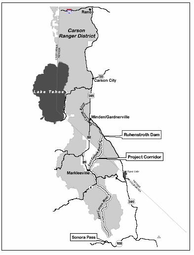
7 Executive Summary Objective This strategy lays out a solid plan of action for enhancing the management of National Forest System lands and details a vision for the future of the East Carson River country. The strategy outlines recommendations for enhancing recreational experiences, ecosystem functions, transportation, and the scenic beauty of this area. It provides information for site-specific decisions, sets priorities for management actions, and identifies special situations needing attention. While it does contain specific recommendations, it does not make final decisions. Any site specific action that would be undertaken as a result of these recommendations will require compliance with the National Environmental Policy Act that includes an environmental analysis and opportunities for public comment. Background descends through a variety of mountain, meadow, and canyon habitats into the sagebrush and desert shrub of the Great Basin in Nevada. It is recognized as only one of two major free flowing rivers on the eastern Sierra. The study section flows approximately 52 miles from the Carson-Iceberg Wilderness in Alpine County, California into Douglas County, Nevada. The river passes through the Carson- Iceberg Wilderness on the Humboldt- Toiyabe National Forest, BLM, other Forest Service lands, private, California Fish & Game lands and traditional Washoe Tribal lands. The 10.2 miles from Hangman s Bridge on CA Route 89/4 south of Markleeville downstream to the State line is designated scenic under the California Wild and Scenic Rivers Act. Scenic river segments are defined as free from impoundments, with shorelines or watersheds still largely primitive and shorelines largely undeveloped, but accessible in places by roads. The East Fork of the Carson River originates in a glaciated alpine valley at the base of 11,500 ft Sonora Peak, near the border of Alpine and Mono counties in California. It drops steeply from the rugged alpine country of the Sierra Crest to the pastoral lowlands of Carson Valley where it joins with the West Fork to form the main stem of the Carson River. It Figure 1: Headwaters of the East Carson near Sonora Pass 1

8 The wide range of vegetation communities along the East Fork of the Carson River creates a mosaic of landscapes which are both biologically diverse and highly valuable to a variety of wildlife species. Beginning from the upper reaches of the river to its confluence with Wolf Creek, vegetation includes primarily wet meadow riparian interspersed with mixed conifer and aspen. A pure strain of Lahontan cutthroat trout, a threatened species, occupy approximately five miles of the River from the headwaters to Carson Falls. Stretching north to Hangman s Bridge, the riparian canopy becomes fairly open and intermittent and is dominated primarily by cottonwood and willow. Bald eagles have been observed perched in the cottonwoods in this area while foraging in the river. From Hangman s Bridge north to the Ruhenstroth dam, the river corridor contains a patchy distribution of mixed aged willow/alder shrublands expanding into upland communities of sagebrush, bitterbrush and mahogany. River otters are known to occur in this section of the River and much of the upland shrub communities are utilized by the Turtle Rock and Carson River deer herds as important winter range. The East Carson country has a rich cultural heritage. People have occupied of the eastern Sierra Nevada for 12,000 years. Through out this time people have used areas within and surrounding the East Fork of the Carson River for habitation, hunting, gathering plants, mining, and spiritual reasons. As the first leaves appeared in the warming sun my People went high into the mountains, to the headwaters of the Carson River and to Tahoe, the big lake in the sky. In these places they would hunt with their bows for deer and mountain sheep, forage highland plants, and net trout in the clear alpine waters. Washoe Village Elder 2
9 What We Found: Based on our analysis we have identified the following topic areas: 1) Recreation; 2) Wildlife/Plant Habitat; 3) Fish and Amphibian Habitat 5) Watershed Resources; 6) Heritage Resources; 7) Wild and Scenic River Management Recreation Current Situation The East Carson River country provides a wide variety of recreation opportunities, but is declining in quality due to overuse in some areas. Use of the river corridor for day use is the predominant recreation use. This includes floating during the spring runoff season, off-highway vehicles, hunting, and fishing outside the Wilderness. Overnight camping is increasing both during the float season as well as at other times of the year where motorized vehicles can drive to the river. An increase in user created camping sites, fire rings, trash, and new or expanded impact areas from additional use is occurring, particularly at the hot spring area in Alpine County. Recommendations Reduce sanitation problems along the river by closing the overflowing unmaintained pit toilet at the hot springs. Establish a requirement to pack out human waste. Enhance signage along the river, at vehicle access points, and at the put in and take out areas for rafting. Protect the main Hot Springs area by providing overnight camping opportunities in other areas. Allow for current pool development at the Hot Springs that are natural in appearance and compatible with the natural character of the River corridor. Protect the Hot Springs from overuse by educating visitors that no new permanent pools, benches or other structures will be constructed at any of the hot springs in the river corridor. Protect stream banks and water quality by establishing camping at designated sites only downstream from Centerville Flat. Clearly sign these sites. 3
10 Re-engineer/relocate the whitewater rafting take out point and inform responsible state, local, and private parties about the safety issues at Ruhenstroth dam. Wildlife/Plant Habitat Current Situation Much of the Carson River corridor provides excellent winter range for mule deer as well as suitable habitat for a variety of other wildlife species, including sage grouse and pygmy rabbit. However, some of the native plant communities in these areas are currently being converted to homogenous stands of cheatgrass and no longer provide adequate forage or cover for these species. Recommendations Protect vital riparian habitat from being cut away by implementing a no woodcutting policy in the river corridor. Implement a native plant restoration project in cheatgrass areas to enhance mule deer and other mammal and bird habitat. Enhance signage Weed management Current Situation The dense riparian vegetation found along the river corridor provides important habitat for a variety of migratory songbirds. However, large infestations of noxious weeds, including yellow starthistle hoary cress, Canada thistle, bull thistle, Russian knapweed and tall white top, are currently outcompeting and replacing native riparian vegetation along sections of the river. These weeds can also be carried downstream into agricultural areas and damage croplands. While not classified as an official noxious weed, cheatgrass has also invaded much of the lower stretch of the river, replacing native vegetation, increasing fire danger, and spreading onto adjacent private lands. Recommendations Accelerate weed control/eradication efforts in the River corridor. Coordinate and cooperate funding and weed eradication projects with the Alpine/ Upper Carson River Invasive Weed management group Enhance signage and guidance regarding invasive species Fish and Amphibian Habitat Current Situation The recreational fishery habitat between Carson Falls and Ruhenstroth Dam is being affected by loss of streamside vegetation, hiking, recreational fishing, horse and stock use, dispersed camping, improper disposal of human waste, leave-no-trace principles not being practiced, usage of nondesignated roads, cattle grazing, and the expansion of noxious weeds. Portions of the current habitat of the Lahontan Cutthroat Trout, a threatened and endangered fish, are being affected 4

11 by hiking trails in the vicinity of the East Fork of the Carson River. Recommendations Manage recreation use along the river as outlined in the recreation section in order to enhance and protect fish habitat. Re-route portions of the hiking trails along the river in the Carson Iceberg Wilderness in order to protect the critical aquatic refuge for Lahontan Cutthroat Trout. Establish a critical aquatic refuge to protect threatened species habitat upstream of Carson Falls. A stream corridor condition assessment for the Upper Carson River watershed was completed in The assessment team recommended floodplain restoration on the reach of the East Fork adjacent to HWY 4 between the confluence with Wolf Creek downstream to Hangman s Bridge. Much of this reach has been impacted by the proximity of the highway. Recommendations Pursue opportunities from willing sellers only to acquire easements or property in the River corridor to protect watershed and other resources. Due to the limited private land base in California, acquisitions should be limited to the lower stretches of the river in Nevada. Harden campsites and roads at the Centerville Flat dispersed camping area to protect watershed resources. Designate campsites on Forest Service lands in the river corridor downstream from Centerville Flat in order to protect watershed and other resources. Heritage Resources Figure 2: Lahontan Cutthroat Trout above Carson Falls Watershed Resources Current Situation Current Situation The River is within the traditional land use areas of the Washoe people. They had temporary camps for resource extraction and long term occupation sites along the East Fork of the Carson River in addition to its use as a travel route. Cultural resources of the Washoe people occur on these lands. 5

12 Discovery of the Comstock Lode in 1859 brought an influx of prospectors and in 1860 gold was discovered along the River at what would become the Silver Mountain Mining District. Construction of mines, mills and towns have all left physical remains along the River. Recommendations Monitor cultural sites near hot springs and adjust management as necessary to address any problems. Evaluate Centerville Flat for heritage resources. Harden campsites and roads at the Centerville Flat dispersed camping area Flat to protect historic resources. Enhance signage related to protection of heritage resources. Consult with the Washoe Tribe on issues related to their cultural resources. and erosion, the potential for a water diversion structure near Horseshoe Bend, and the potential for future restrictions on private land use, livestock grazing, weed management, and hazard tree removal. Public concerns also include the need to manage the river as wild and scenic in order to protect recreation, watershed, and wildlife values and to protect the free flowing river for the use and enjoyment of future generations. It s recognized that a wild and scenic designation could enhance management by providing additional appropriated and grant funding for weed control, recreation use, watershed enhancement and other purposes. Recommendations Move forward with wild and scenic suitability study. Consider excluding portions of Wild and Scenic River Management Current Situation The East Fork of the Carson River was determined to be eligible for Wild and Scenic River status in the Toiyabe Plan of A suitability study to recommend all, portions, or none of the River for designation as Wild and Scenic has not been completed yet. Public concerns about management for wild and scenic river values include the need to protect Highway 4 from flooding the river with potential conflicts, such as those along Highway 4 and at Horseshoe Bend. Ensure no interference with use of private lands along the river. Ensure that no new 6
13 Roads requirements for fencing private lands are established. Preserve current livestock grazing opportunities. Preserve potential for weed management. Preserve current practice of removing hazard trees. Current Situation Off-highway vehicles (OHV) often pass through tribal (BIA allotment lands), private and national forest system lands to access the river. Damage has occurred to tributaries such as Bryant Creek and its riparian zone, as well as to private property including River Ranch, and the river corridor especially at the Hot Springs. Some motorized users coming from Haypress Flat down the Barney-Riley Trail are trespassing through California Fish & Game property at the Hot Springs. During most of the year when there is low water flow (i.e. unsuitable for float trips), some users cross the river in their vehicles onto the west side to access the Hot Springs area which is closed to motorized vehicles. Motorized users have historically accessed the river on Forest Roads 689 & 690 from China Springs area in Douglas County, Nevada. Day and overnight use in this area is increasing and impacting the riverbank. New campsites and fire rings are appearing and used more often along this section of the river down to private property at River Ranch. The private property owners at River Ranch replaced a wire fence several years ago with a pipe and rail fence set in concrete to gate off motorized use trespassing on their property. Occasionally, OHV s have removed the parking lot barricades at the Take-out in order to drive down to and/or through the river. OHV web sites have been encouraging trespass vehicle use on areas closed to vehicles. Recommendations Keep Forest Roads 689 and 690 in Douglas County open for public access to the river upstream of Horseshoe Bend. Work with Alpine County and Cal Fish and Game on vehicle management on route 310 across from the hot springs. Vehicles are going through Cal Fish and Game lands and causing damage in the hot springs area. Work with Douglas County, BIA, and the Washoe Tribe on management of Forest Road 189. It goes mostly through private/indian allotment land, causing damage to Bryant creek and hot springs area. Monitor OHV/Hot Springs web sites and send them notices about legal access and responsibility. Protect stream bank integrity, visual quality, and water quality by enhancing public education, signage and enforcement of closed areas. Rehabilitate new user created roads in areas set aside for non-motorized use. 7
14 Close and rehab the user created road/hill climb above the hot springs. Coordinate with the BLM on future management of the Scossa Canyon road. 8

15 Appendix Chapter 1: Characterization This is the first of four chapters that document the East Carson River Strategy. In this chapter, the dominant features, human uses, and land use status of the river are highlighted. Chapter 2 identifies the issues that focus analysis. Chapter 3 describes current and desired conditions in terms relevant to core issues. Chapter 4 describes recommendations for management activities that move conditions from current to desired and are responsive to the issues. River Landscape Character The East Fork of the Carson River originates in a glaciated alpine valley at the base of 11,500 ft Sonora Peak, near the border of Alpine and Mono counties in California. It drops steeply from the rugged alpine country of the Sierra Crest to the pastoral lowlands of Carson Valley where it joins with the West Fork to form the main stem of the Carson River. It descends through a variety of mountain, meadow, and canyon habitats into the sagebrush and desert shrub of the Great Basin in Nevada. It is recognized as only one of two major free flowing rivers on the eastern Sierra. The study section flows approximately 52 miles from the Carson-Iceberg Wilderness in Alpine County, California into Douglas County, Nevada. The river passes through the Carson- Iceberg Wilderness on the Humboldt- Toiyabe National Forest, BLM, other Forest Service lands, private, California Fish & Game and traditional Washoe Tribe lands. The 10.2 miles from Hangman s Bridge on CA Route 89/4 south of Markleeville downstream to the State line is designated scenic under the California Wild and Scenic Rivers Act. Scenic river segments are defined as.free from impoundments, with shorelines or watersheds still largely primitive and shorelines largely undeveloped, but accessible in places by roads. The section of the river from the confluence with Wolf Creek upstream to Carson Falls is a California state designated Wild Trout The section from Hangman s Bridge downstream to CA/NV state line is designated California Wild and Heritage Trout catch and release waters. The wide range of vegetation communities along the East Fork of the Carson River creates a mosaic of Figure 3: Carson Falls 9

16 landscapes which are both biologically diverse and highly valuable to a variety of wildlife species. Beginning from the upper reaches of the river to its confluence with Wolf Creek, vegetation includes primarily wet meadow Figure 4: Wolf Creek Meadows riparian interspersed with mixed conifer and aspen. Dense patches of willow which occur along this stretch provide high quality habitat for willow flycatcher as well as a multitude of migratory songbirds. A pure strain of Lahontan cutthroat trout, a threatened species, occupy approximately five miles of the River from the headwaters to Carson Falls. Stretching north to Hangman s Bridge, the riparian canopy becomes fairly open and intermittent and is dominated primarily by cottonwood and willow. Bald eagles have been observed perched in the cottonwoods in this area while foraging in the river. From Hangman s Bridge north to the Ruhenstroth dam, the river corridor contains a patchy distribution of mixed aged willow/alder shrublands expanding into upland communities of sagebrush, bitterbrush and mahogany. River otters are known to occur in this section of the River and much of the upland shrub communities are utilized by the Turtle Rock and Carson River deer herds as important winter range. The East Carson country has a rich cultural heritage. People have occupied of the eastern Sierra Nevada for 12,000 years. Through out this time people have used areas within and surrounding the East Fork of the Carson River for habitation, hunting, gathering plants, mining, and spiritual reasons. Temporary camps along the river were maintained by specific families as seasonal fishing camps. The Bagley Valley area in particular was used for processing food plants and hunting Mountain sheep (d Azevedo 1956). Discovery of the Comstock Lode in 1859 brought an influx of prospectors and in 1860 gold was discovered along the River at what would become the Silver Mountain Mining District. The influx of prospectors, laborers and merchants lead to the establishment of the towns of Monitor, Mountain Bullion, and Markleeville. The construction demanded large quantities of timber, which was cut from the mountain forests up slope of the river corridor. In the fall of 1862 the Carson River Lumber Company organized the first wood drive down the 10
17 river. By the mid 1860s large quantities of saw logs were flumed down to the river forming large log runs down the East Fork of the Carson. The last log drive occurred in 1896 (Murphy 1982). Land Use Status The Toiyabe National Forest adopted a Land and Resource Management Plan (Forest Plan) in It provides guidance based on management areas. The East Carson River country falls into Management Area 3, Walker and Management Area 5, Wilderness. Toiyabe Forest Plan Management Area MA-3: Alpine Management Area Direction Protect the East Fork of the Carson River from any activity that may reduce its suitability for Wild, Scenic, and/or Recreational River classification until a suitability study is completed and recommendation is made. Interim management will be in accordance with Wild and Scenic River Management Guidelines. Cooperate with the BLM to improve the quality of the hot springs along the river. Miles 25 MA-5: Wilderness Wilderness will be managed to provide outstanding opportunities for solitude, physical and mental challenge, primitive recreation, and to maintain wilderness characteristics of the land. 52 Sierra Framework Amendment All of the National Forest System lands in the analysis area were included in the Sierra Nevada Forest Plan Amendment of 2004, commonly known as the Sierra Framework Amendment. This amendment established management direction for old forest ecosystems; aquatic, riparian, and meadow ecosystems; fire and fuels management; and control of noxious weeds. Tools to address these problem areas include landscape analyses, riparian conservation areas, and critical aquatic refuges. Landscape Analyses The East Carson River Strategy is a type of landscape analysis as identified in the Sierra Framework Amendment. It characterizes the current status, and future trends of an area. It identifies opportunities and priorities for correcting problems. Landscape analyses are not decision processes. They only identify opportunities for needed projects. Project level plans are decision processes subject to the National Environmental Policy Act. Riparian Conservation Areas The Framework amendment identified riparian conservation areas around lakes and along perennial and intermittent streams. They are managed to maintain or restore the 11
18 structure and function of aquatic, riparian and meadow ecosystems. Standards and guidelines were developed to protect water quality, biological characteristics, in-stream flows, and hydrologic connectivity. Other measures ensure a renewable supply of large down logs that can reach the stream channel and provide suitable wildlife habitat. Standards and guidelines ensure that management activities including fuels reduction projects enhance or maintain physical and biological characteristics associated with aquatic and riparian dependent species. Critical Aquatic Refuges Critical aquatic refuges provide habitat for native fish, amphibian, and aquatic invertebrates. They provide protection for threatened, endangered, or sensitive species, including Lahontan cutthroat trout. 2

19 Chapter 2: Issues Issues identify the resource concerns or opportunities that are unique or relevant to the East Carson River. Their relevance is determined by their relationship to ecosystem functions and human uses of National Forest System Lands along the River. The analysis of issues is focused by identifying key questions for each issue. Recreation The East Carson River country provides a wide variety of recreation opportunities, but is declining in quality due to overuse in some areas. Use of the river corridor for day use is the predominant recreation use. This includes floating during the spring runoff season, off-highway vehicles, hunting, and fishing outside the Wilderness. Overnight camping is increasing both during the float season as well as at other times of the year where motorized vehicles can drive to the river. An increase in user created camping sites, fire rings, trash, and new or expanded impact areas from additional use is occurring, particularly at the hot spring area in Alpine County. Key Questions: What are the appropriate recreation opportunities along the East Carson River? What management actions are needed to accommodate those opportunities? Wildlife/Plant habitat Much of the Carson River corridor provides excellent winter range for mule deer as well as suitable habitat for a variety of other wildlife species, including sage grouse and pygmy rabbit. However, some of the native plant communities in these areas are currently being converted to homogenous stands of cheatgrass and no longer provide adequate forage or cover for these species. Key Questions: What actions are needed to preserve and restore habitat for mule deer and other wildlife within the East Fork of the Carson River corridor? How can native plant communities be protected along the River? Weed management Figure 5: Yellow starthistle The dense riparian vegetation found along the river corridor provides important habitat for a variety of migratory songbirds. However, large infestations of noxious weeds, including yellow starthistle and tall white top, are currently out-competing and replacing native riparian vegetation along sections of the river. These weeds can also be carried downstream into agricultural areas and damage croplands. While not classified as an official noxious weed, cheatgrass has also invaded much of the lower stretch of the river, replacing 3

20 native vegetation, increasing fire danger, and spreading onto adjacent private lands. Key Questions What actions are necessary to reduce noxious weeds and restore native riparian plant communities? What actions are needed to prevent future spread of noxious weeds along the river? Fish and amphibian habitat The recreational fishery habitat between Carson Falls and Ruhenstroth Dam is being affected by loss of streamside Figure 6: Lahontan cutthroat trout above Carson Falls vegetation, hiking, recreational fishing, horse and stock use, dispersed camping, improper disposal of human waste, leave-no-trace principles not being practiced, usage of nondesignated roads, cattle grazing, and the expansion of noxious weeds. Portions of the current habitat of the Lahontan Cutthroat Trout, a threatened and endangered fish, are being affected by hiking trails in the vicinity of the East Fork of the Carson River. Key Questions: What are the objectives for preserving/enhancing fisheries and amphibian habitat within the East Fork Carson River corridor? What projects are needed to achieve those objectives? Watershed Conditions The East Carson River has its headwaters on the eastern side of the Sierra Crest just south of Sonora Pass, at an elevation near 11,000 feet. From the headwaters the river flows north through NF, BLM and private lands, until its confluence with the West Fork Carson River approximately 56 miles downstream. The primary tributaries in the upper reaches of the East Carson River, above Ruhenstroth Dam, are Silver King, Wolf, Pleasant Valley and Markleeville Creeks. Snowpack development and melt are the dominant factors in producing runoff in the East Carson River. During most years, precipitation falls as snow from November through April. The snow pack begins to melt in March, typically reaches a maximum in May, and then recedes through the remainder of the summer. The East Fork Carson River has been gauged below its confluence with Markleeville Creek for peak flows since 1961 and daily flows beginning in Peak flows have ranged from 586 cfs (cubic feet per second) during the drought year of 1977, to 18,900 cfs during the New Years flood of Key Questions: What are the appropriate water quality conditions? What projects are needed to achieve those conditions? Heritage resource management The River is within the traditional land use areas of the Washoe people. They had temporary camps for resource extraction and long term occupation sites along the East Fork of the Carson 4
21 River in addition to its use as a travel route. Discovery of the Comstock Lode in 1859 brought an influx of prospectors and in 1860 gold was discovered along the River at what would become the Silver Mountain Mining District. Construction of mines, mills and towns have all left physical remains along the River. Key Questions: Where are key cultural resource areas? What measures are needed to protect these areas? Wild and Scenic River Management The East Fork of the Carson River was determined to be eligible for Wild and Scenic River status in the Toiyabe Plan on A suitability study to recommend all, portions, or none of the River for designation as Wild and Scenic has not been completed yet. Public concerns about management for wild and scenic river values include the need to protect Highway 4 from flooding and erosion, the potential for a water diversion structure near Horseshoe Bend, and the potential for future restrictions private land use, livestock grazing, weed management, and hazard tree removal. Public concerns also include the need to manage the river as wild and scenic in order to protect recreation, watershed, and wildlife values and to protect the free flowing river for the use and enjoyment of future generations. It s recognized that a wild and scenic designation could enhance management by providing additional appropriated and grant funding for weed control, recreation use, watershed enhancement and other purposes. Key Questions: Should a suitability study be completed? If yes, what parameters and river sections should be considered in the study? Roads Off-highway vehicles (OHV) often pass through tribal, private and national forest system lands to access the river. Damage has occurred to tributaries such as Bryant Creek and its riparian zone, as well as to private property including River Ranch, and the river corridor especially at the Hot Springs. Some motorized users coming from Haypress Flat down the Barney-Riley Trail are trespassing through California Fish & Game property at the Hot Springs. During most of the year when there is low water flow (i.e. unsuitable for float trips), some users cross the river in their vehicles onto the west side to access the Hot Springs area which has been/is closed to motorized Key Questions: What is the appropriate road network for the River Corridor? What measures are needed to maintain this network and keep vehicles on the roads? 5
22 Chapter 3: Current and Desired Conditions This chapter displays information about conditions as they are now and as they should be in the future. The description of current conditions is focused on the issues and key questions displayed in Chapter 2. Desired conditions are derived from the Forest Plan, as amended by the Sierra Framework. This provides a contemporary, comprehensive set of goals relevant to the River. Recreation Current Conditions Developed Recreation Facilities The BLM manages the Hangman s Bridge river launch site on Highway 89/4 just south of Markleeville, CA. It has a single riser SST and a small parking lot whose vehicle capacity is routinely exceeded during the spring float season. It also serves as a parking lot for fishers accessing the catch and release waters. A gated dirt road leads over a mile downstream to the river. The non-motorized path down to the river has an uneven surface from erosion, is not wide enough for an inflated raft, and the beach width is inadequate for the number of boats and people The gravel bar in the floodplain adjacent to Highway 4/89 was created during the January 1997 flood less than ½ mile south of Hangman s. This undeveloped area is mostly on private land belonging to Carson River Resort with a small portion on BLM. The public and customers staying at the Resort use this site to launch more than Hangman s. It often fills before Hangman s and/or serves as the overflow from Hangman s on busy float days. In recent years, with the increase in private floaters, both sites are often filled to capacity and users park on the shoulder of the State highway. The Forest Service s Markleeville Campground is less than a mile from the BLM Hangman s Bridge launch. It has 10 campsites, water, and a single riser SST situated on Markleeville Creek (which feeds into the main river). The Carson River Resort is located about a mile upstream of the Hangman s Bridge launch and is privately owned and operated. It has a retail store, campground, rental cabins, and direct river access. The Forest Service manages the Carson River Take-out in Douglas County, NV just upstream from Ruhenstroth Dam. It has a double riser SST, large multi-lot parking area, and take-out ramp that was severely damaged by flooding in early It has been routinely vandalized and tagged since its construction in In 2004, vandals poured gasoline down into the restroom sewage vaults. The resulting fire required replacing the entire vault below ground, the toilet risers, and the large stack that vents the building at a cost over $12,000. Most of the year it serves as a destination for local users who sometimes engage in illegal non-recreational activities. The takeout ramp down to and in to the river was partially washed out during flooding in early Currently, routine maintenance is provided through an agreement with the Douglas County Department of Parks and Recreation. There are no trailheads directly on the River. The East Carson River Trail in 6
23 the Carson-Iceberg Wilderness begins at the High Trail/East Carson River Trailhead in Wolf Creek Meadows. Dispersed Recreation Within the Carson-Iceberg Wilderness use of the river corridor is limited to nonmotorized muscle means e.g. horses and on foot. Fishing, day hiking, equestrian, and overnight camping are the primary activities. Overnight use concentrates on the river corridor and is primarily within 100 of the river edge. Fire rings, trash, barren soil, firewood collection, horse tethering sites, and user created paths occur in multiple places. A low number of river users come in from Monitor Pass road then down Bagley Valley to the Vaquero Camp area. Use of the river corridor for day use is the predominant recreation use. This includes floating during the spring runoff season, off-highway vehicles, hunting, and fishing outside the Wilderness. During the highest flows in the spring, floaters desiring a Class III river experience launch informally at the Highway 4 bridge near the Wolf Creek Road junction and run the river down to Hangman s. Often they arrange a shuttle at Hangman s to take them back upriver to rerun of lap the same section. Overnight camping is increasing both during the float season as well as at other times of the year where motorized vehicles can drive to the river. An increase in user created camping sites, fire rings, trash, and new or expanded impact areas from additional use is occurring. Leave No Trace guidelines for western rivers are not being followed by most users especially in the non-float season. The number of commercial outfitter/guides under permit to the Forest Service for guiding fishing and floating the river has remained relatively constant from year to year. Commercial overnight use is not allowed at the Hot Springs and commercial party size is restricted. However by contrast, the number of private floaters and fishermen has increased approximately fourfold in the last fifteen years. Fishing use (both legal and poaching) of the river downstream from Hangman s Bridge has increased markedly since it was designated a California Wild and Heritage Trout section. The variety of watercraft going down the river has also increased in diversity and numbers. Year-round day and overnight use is highest and most concentrated at the natural Hot Springs approximately halfway between Hangman s and the Nevada takeout. Prior to the unauthorized construction of two stone basins in the Hot Springs feeder creek starting in 2000, use and impacts monitored year after year at the Hot Springs remained stable and low. An inoperable fiberglass portable toilet was removed in the mid-1990 s by the Forest Service and replaced by a hand dug pit toilet. It did not show any increase in use until the early 2000 s and is now full. Following construction of the stone pools, use and impacts have been steadily increasing year-round. Additional unauthorized work on the stone pool structures that allow some control of the water temperature in the pools has now created new year-round use at the site. Impacts that are increasing at the Hot Springs from public use include: OHV hill climbing, cutting of live trees for firewood, 7
24 area devoid of dead downed wood for fires, vandalism of archeological resources, proliferation of fire rings, increase in size of the historic camping area, creation of new campsites fanning out from the historic camping area including new campsites up and downstream, improperly disposed of human waste, trampling of the adjacent riverbank (from watercraft and vehicles) and area surrounding the stone pools down to bare soil, additional new unauthorized structures being built in and around the two stone pools, increased OHV use of the site year-round. Since the stone pools were constructed at the Hot Springs new day & overnight use, campsites, footpaths, impacts, and human made structures are appearing in other nearby hot springs. In 2005 volunteers who assisted river users at the put-ins found out that many river users are coming from the west slope of the Sierra where they encountered rivers that are more regulated. The main reasons they come to the Carson are for the Hot Springs, scenery, and lack of regulation & permits. Desired Future Conditions Developed Recreation A launch facility accommodates floaters desiring the Wolf Creek to Hangman s section along Highway 4 at the upper end of this section. The BLM s launch facility at Hangman s Bridge provides adequate parking, restrooms, river access, river user & fisherman information, and selfregistration river permit system if in effect. Interpretive, river user, fisheries habitat, and fishermen information is provided in conjunction with the Ebbetts Pass National Scenic Byway. The Forest Service s Markleeville Campground accommodates overnight river users who are floating and/or fishing the Wild Trout section below Hangman s. The Carson River Take-out in Douglas County, Nevada has a long term maintenance agreement that has a regular presence, cleans the facilities, and maintains the improvements. The Forest Service and Douglas County routinely patrol the take-out year-round so visitors have security and the site is used strictly for legal recreational purposes. The Centerville Flats dispersed camping area is clearly defined to protect its archeological and historical resources as well as the riverbank. River access from the High Trail/Carson River Trailhead and Bagley continues to adequately provide river access in the Carson-Iceberg Wilderness. Dispersed Recreation The use within the Carson-Iceberg Wilderness continues to be limited under the Wilderness Act to nonmotorized muscle means e.g. horses 8

25 and on foot. Fishing, day hiking, equestrian, and overnight camping are the primary activities. BLM, Forest Service, and California Department of Fish & Game employees regularly and routinely patrol the river corridor. They provide information, maintain facilities, enforce regulations, and enforce state fishing regulations. Users practice guidelines provided in the Leave No Trace-Outdoor Skills & Ethics booklet for Western River Corridors year-round. Leave No Trace information and regulations are issued with each permit issued. As a result, the river corridor condition is on an upward trend and users have a quality recreation experience. Overnight camping and impacts from motorized and non-motorized users have diminished. There is no increase in user created camping sites, fire rings, trash, human sanitation problems, and new or expanded user impact areas. The number of commercial outfitter/guides under permit to the Forest Service for guiding fishing and floating the river provides a quality recreation float experience for the public. Illegal fishing use along the river downstream from Hangman s Bridge does not occur. The sport fisheries objectives of the California Wild and Heritage Trout section being met and sustained. The number of campsites and overnight users is stable. Day and overnight use levels provide river users a quality uncrowded experience in a natural setting. Fire hazards and evidence of campfires outside designated campsites is at a low level. The Hot Springs and other sensitive river corridor areas no longer have unauthorized structures being constructed. Archeological resources in and around the Hot Springs and other culturally sites have been protected. Native vegetation has returned to the area around the Hot Springs and other formerly impacted sites. Watershed Current Condition The East Carson River has its headwaters on the eastern side of the Sierra Crest just south of Sonora Pass, at an elevation near 11,000 feet. From the headwaters the river flows north through NF, BLM and private lands, until its confluence with the West Fork Carson River approximately 56 miles downstream. The primary tributaries in the upper reaches of the East Carson River, above Ruhenstroth Dam, are Silver King, Wolf, Pleasant Valley and Markleeville Creeks. Figure 7: East Carson River Canyon near Bagley Valley 9

26 Snowpack development and melt are the dominant factors in producing runoff in the East Carson River. During most years, precipitation falls as snow from November through April. The snow pack begins to melt in March, typically reaches a maximum in May, and then recedes through the remainder of the summer. The East Fork Carson River has been gauged below its confluence with Markleeville Creek for peak flows since 1961 and daily flows beginning in Peak flows have ranged from 586 cfs (cubic feet per second) during the drought year of 1977, to 18,900 cfs during the New Years flood of The East Fork Carson River is dominated by poorly consolidated volcanic rocks that tend to be friable and very erosive. In the East Fork, channels are strongly incised into this material, and adjacent slopes are extremely steep. Large landslides throughout the East Fork watershed cause the episodic delivery of sediment to the channel. On the East Fork, just downstream of the Wolf Creek confluence, a massive landslide is evident that dates back to at least the 1960 s. This landslide is currently Figure 8: East Carson River upstream of Centerville 10 active, with additional movement occurring during high flows. During the 1997 flood the landslide appears to have blocked the entire channel, resulting in channel aggradation upstream and incision of the landslide mass. Water Quality: There is a limited amount of water quality data for the East Fork Carson River and its tributaries. Currently, Indian Creek, Bryant Creek (both CA & NV), Leviathan Creek, Monitor Creek, and the reach of the East Carson River from state line downstream to HWY 395 have been listed under Section 303(d) of the Federal Clean Water Act. Bryant Creek, Leviathan Creek and Monitor Creek are all affected by acid mine drainage from Leviathan Mine and Colorado Hill and are listed for various metals. Water quality in these creeks is being improved through the CERCLA process of mine site restoration. Indian Creek is listed for pathogens from grazing related sources. The reach of the East Carson River in Nevada is currently listed for turbidity and iron. Although NV doesn t list likely sources, turbidity is caused by erosion which can be generated from OHV use,
27 grazing and other disturbances. Much of the East Carson River in Nevada was previously listed for nitrate, phosphates, and total dissolved solids. One of the sources for these constituents is grazing. These constituents may still exceed water quality standards, but are no longer listed since the state developed TMDLs. Two efforts are going on to collect water quality data in the Carson River watershed. The Carson Water Subconservancy District is leading the effort to conduct a comprehensive water quality monitoring program for the Upper Carson River Watershed in Alpine County, California. The purpose of this project is to identify causes of water quality problems and provide current information on water quality conditions on the West Fork and East Fork of the Carson River and Indian Creek, a tributary to the East Fork. The data has been collected and is currently being analyzed by the Desert Research Institute. The CWSD expects to have a draft Carson River management plan, which will include this water quality data, completed in June, with the final plan out in December. The Alpine Watershed Group has created a volunteer citizen water quality monitoring program. This program, which began in spring 2005, includes two sampling sites on the East Carson River and one site on Markleeville Creek. This program may provide some useful baseline data if it is continued for the next five years. One of its main purposes at this point is to inform and engage the community in effective watershed stewardship. Watershed Condition: A stream corridor condition assessment for the Upper Carson River watershed was completed in The assessment was conducted for the Alpine Watershed Group. The purpose of the project was to describe the current condition of both the West Fork and East Fork of the Carson River and provide restoration recommendations. The assessment team recommended floodplain restoration on the reach of the East Fork adjacent to HWY 4 between the confluence with Wolf Creek downstream to Hangman s Bridge. Much of this reach has been impacted by the proximity of the highway. Recommendations were also made for three reaches of Markleeville Creek. The Alpine Watershed Group, in conjunction with the Carson RD, is beginning the restoration process on the reach of stream through the guard station. Desired Conditions Water quality meets the goals of the Clean Water Act and California state water quality standards. The physical structure and condition of stream banks and shorelines minimizes erosion and sustains desired habitat diversity. Fisheries Current Conditions The East Fork Carson River upstream of Carson Falls supports a small population of Lahontan cutthroat trout, a Federally-listed threatened species. The East Fork Carson River from Carson Falls downstream to Ruhenstroth Dam supports a highly popular recreational fishery. This same stretch of river between Carson Falls and Ruhenstroth Dam was also 11
28 historically inhabited by Lahontan cutthroat trout. The Lahontan cutthroat trout and recreational fishery habitat within the East Fork Carson River corridor is at less than optimum condition due to the impacts from loss of streamside vegetation, hiking, recreational fishing, horse and stock use, dispersed camping, improper disposal of human waste, leave-no-trace principles not being practiced, usage of nondesignated roads, cattle grazing, and the expansion of noxious weeds. The East Fork Carson River corridor also provides important habitat for mountain yellow-legged frogs and Yosemite toads, two species of amphibians whose populations have declined throughout the Sierra Nevada mountain range. Recreational Fisheries The East Fork Carson River between Carson Falls and Ruhenstroth Dam is known for great recreational fishing opportunities. Rainbow, brook, and brown trout are common throughout this area. The California Department of Fish and Game and Alpine County stock the East Fork Carson River with these nonnative fishes regularly. The recreational fishery habitat between Carson Falls and Ruhenstroth Dam is being affected by loss of streamside vegetation, hiking, recreational fishing, horse and stock use, dispersed camping, improper disposal of human waste, leave-no-trace principles not being practiced, usage of nondesignated roads, cattle grazing, and the expansion of noxious weeds. If managed inappropriately, all of these activities and impacts have the potential to result in severe degradation of the recreational fishery habitat. Lahontan Cutthroat Trout The Carson River Watershed historically provided an estimated 300 miles of stream habitat for the native Lahontan Cutthroat trout. Populations of these fish within the watershed were interactive and interconnected, and therefore these metapopulations had high genetic diversity and were capable of long term persistence through adverse conditions. Currently the Lahontan cutthroat trout occupies approximately 9.0 miles of habitat in the Carson River drainage: approximately 3.0 percent of their historic range. Lahontan cutthroat trout have been introduced into six Carson River tributaries that were previously unoccupied by Lahontan cutthroat trout. The entire East Fork Carson River upstream of Ruhenstroth Dam was historically inhabited by Lahontan cutthroat trout. The Lahontan cutthroat trout was listed as endangered in 1970 and reclassified to threatened in 1975 to allow regulated fishing and more management flexibility. The primary causes for the decline of Lahontan cutthroat trout include: 1) reduction and alteration of stream discharge; 2) alteration of stream channels and morphology; 3) degradation of water quality; and 4) introductions of non-native fish species. The Carson River corridor downstream of Carson Falls is primarily inhabited by non-native fishes which include: rainbow trout, brook trout, and brown trout. A small population of pure Lahontan cutthroat trout still exists in the East Fork Carson River upstream of Carson Falls. 12
Decision Memo for Desolation Trail: Mill D to Desolation Lake Trail Relocation
 for Salt Lake County, Utah Uinta-Wasatch-Cache National Forest Salt Lake Ranger District 1. Background The present location of the Desolation Trail (#1159) between Mill D and Desolation Lake follows old
Decision Memo Ice Age Trail Improvement (CRAC 37)
") Decision Memo Ice Age Trail Improvement (CRAC 37) U.S. Forest Service Chequamegon-Nicolet National Forest, Medford-Park Falls Ranger District Taylor County, Wisconsin T32N, R2W, Town of Grover, Section
Decision Memo Ice Age Trail Improvement (CRAC 37) U.S. Forest Service Chequamegon-Nicolet National Forest, Medford-Park Falls Ranger District Taylor County, Wisconsin T32N, R2W, Town of Grover, Section
Proposed Action. Payette National Forest Over-Snow Grooming in Valley, Adams and Idaho Counties. United States Department of Agriculture
 United States Department of Agriculture Forest Service January 2012 Proposed Action Payette National Forest Over-Snow Grooming in Valley, Adams and Idaho Counties Payette National Forest Valley, Adams
Tracy Ridge Shared Use Trails and Plan Amendment Project
 Tracy Ridge Shared Use Trails and Plan Amendment Project Scoping Document Forest Service Allegheny National Forest Bradford Ranger District McKean, County, Pennsylvania In accordance with Federal civil
BACKGROUND DECISION. Decision Memo Page 1 of 6
 DECISION MEMO DEVIL S ELBOW BY-PASS, BOUNDARY TRAIL NO.1 U.S. FOREST SERVICE T9N, R7E, SECTION 9 RANGE 5E COWLITZ COUNTY WA MOUNT ST. HELENS NATIONAL VOLCANIC MONUMENT, GIFFORD PINCHOT NATIONAL FOREST
Connie Rudd Superintendent, Black Canyon of the Gunnison National Park
 National Park Service U.S. Department of the Interior Black Canyon of the Gunnison National Park and Curecanti National Recreation Area Information Brochure #1 Wilderness and Backcountry Management Plan
Theme: Predominately natural/natural appearing; rustic improvements to protect resources. Size*: 2,500 + acres Infrastructure**:
 Recreation Opportunity Spectrum (ROS) Classes The Recreation Opportunity Spectrum (ROS) provides a way to describe the variations in the degree of isolation from the sounds and influences of people, and
White Mountain National Forest
 White Mountain National Forest United States Department of Agriculture Forest Service Eastern Region Boles Brook Snowmobile Bridge Decision Memo Boles Brook Snowmobile Bridge Project Town of Woodstock
Final Recreation Report. Sunflower Allotment Grazing Analysis. July 2015
 Final Recreation Report Sunflower Allotment Grazing Analysis July 2015 Table of Contents Introduction... 3 Affected Environment... 3 Four Peaks Wilderness Area... 3 Dispersed Recreation... 3 Environmental
Fossil Creek Wild & Scenic River Comprehensive River Management Plan Forest Service Proposed Action - details March 28, 2011
 Fossil Creek Wild & Scenic River Comprehensive River Management Plan Forest Service Proposed Action - details March 28, 2011 Primary Goals of the Proposed Action 1. Maintain or enhance ORVs primarily by
Preferred Recreation Recommendations Stemilt-Squilchuck Recreation Plan March 2018
 Preferred Recreation Recommendations Stemilt-Squilchuck Recreation Plan March 2018 Below are the recommended recreation ideas and strategies that package together the various recreation concepts compiled
Crystal Lake Area Trails
 Lake Area Trails Welcome to the Lake area of the Big Snowy Mountains! This island mountain range in central Montana features peaks reaching to 8,600 feet and long, high ridges from which vistas of the
Logo Department Name Agency Organization Organization Address Information 5700 North Sabino Canyon Road
 Logo Department Name Agency Organization Organization Address Information United States Forest Coronado National Forest 5700 North Sabino Canyon Road Department of Service Santa Catalina Ranger District
Buford / New Castle Motorized Trail
 Buford / New Castle Motorized Trail Rifle Ranger District, White River National Forest Garfield County, Colorado Comments Welcome The Rifle Ranger District of the White River National Forest welcomes your
MANAGEMENT DIRECTION STATEMENT June, 1999
 Thompson River District MANAGEMENT DIRECTION STATEMENT June, 1999 for Roche Lake Provincial Park Ministry of Environment Lands and Parks BC Parks Division Table of Contents I. Introduction A. Setting
Yard Creek Provincial Park. Management Plan
 Yard Creek Provincial Park Management Plan Draft January 2010 Yard Creek Provincial Park Management Plan Approved by: telàlsemkin/siyam/chief Scott Benton Bill Williams Squamish Executive Director ation
Rogue River Access and Management Plan Draft Alternatives
 Rogue River Access and Management Plan Draft Alternatives The Rogue River Access and Management Plan was initiated in December, 2011 and is being led by Jackson County Parks (JCP) and Oregon Department
Continental Divide National Scenic Trail Legislative History and Planning Guidance
 Continental Divide National Scenic Trail Legislative History and Planning Guidance Legislation, Policy, and Direction Regarding National Scenic Trails The National Trails System Act, P.L. 90-543, was passed
White Mountain National Forest. Pond of Safety Accessible Trail & Shoreline Access Project. Scoping Report. Township of Randolph Coos County, NH
 White Mountain National Forest United States Department of Agriculture Forest Service Eastern Region Pond of Safety Accessible Trail & Shoreline Access Project Township of Randolph Coos County, NH Scoping
GREENWOOD VEGETATION MANAGEMENT
 APPENDIX G GREENWOOD VEGETATION MANAGEMENT PROJECT RECREATION RESOURCE REPORT Prepared by: Laurie A. Smith Supervisory Forester Stearns Ranger District Daniel Boone National Forest August 4, 2016 The
FINAL TESTIMONY 1 COMMITTEE ON RESOURCES UNITED STATES HOUSE OF REPRESENTATIVES. July 13, 2005 CONCERNING. Motorized Recreational Use of Federal Lands
 FINAL TESTIMONY 1 STATEMENT OF DALE BOSWORTH CHIEF Of the FOREST SERVICE UNITED STATES DEPARTMENT OF AGRICULTURE Before the SUBCOMMITTEE ON FORESTS AND FOREST HEALTH And the SUBCOMMITTEE ON NATIONAL PARKS,
As outlined in the Tatshenshini-Alsek Park Management Agreement, park management will:
 Management Strategy General Strategy The priority management focus for the park is to ensure that its internationally significant natural, cultural heritage and recreational values are protected and that
Existing Resource Information
 Botanical and Wildlife Vegetation alliances/wildlife habitats Grasslands annual/perennial Chaparral mixed/montane/chamise-redshank Riparian montane/valley foothill riparian Sierran mixed conifer Montane
PURPOSE AND NEED. Introduction
 Public Scoping: Allocation of Recreation Capacity for Commercial Outfitter Guide Services on North Kruzof Island Trails (Kruzof Island Outfitter Guide) PURPOSE AND NEED Introduction The U.S. Department
Decision Memo Sun Valley Super Enduro & Cross-Country Mountain Bike Race. Recreation Event
 Decision Memo 2015 Sun Valley Super Enduro & Cross-Country Mountain Bike Race Recreation Event USDA Forest Service Ketchum Ranger District, Sawtooth National Forest Blaine County, Idaho Background The
Piedra River Protection Workgroup Meeting #5 Feb. 21, 2012 Ross Aragon Community Center, Pagosa Springs
 Piedra River Protection Workgroup Meeting #5 Feb. 21, 2012 Ross Aragon Community Center, Pagosa Springs What happened at this meeting? - Identified conservation easements - Discussed In-stream Flows -
Chapter 6: POLICY AND PROCEDURE RECOMMENDATIONS
 Chapter 6 POLICY AND PROCEDURE RECOMMENDATIONS FOR SRRA Below are seven policy elements that should be considered for adoption by the Southwest Regional Recreation Authority of Virginia: 1. Develop strategies
Bear Creek Habitat Improvement Project
 06/10/10 Bear Creek Habitat Improvement Project El Paso County, Colorado Pike National Forest and Colorado Springs Utilities Owned Land Report prepared by: Eric Billmeyer Executive Director Rocky Mountain
Williamson Rock/Pacific Crest National Scenic Trail (PCT) Project EIS. Notice of intent to prepare an Environmental Impact Statement.
 Project EIS. Notice of intent to prepare an Environmental Impact Statement.") [3411-15-P] DEPARTMENT OF AGRICULTURE Forest Service Angeles National Forest; Los Angeles County, CA Williamson Rock/Pacific Crest National Scenic Trail (PCT) Project EIS AGENCY: ACTION: Forest Service,
[3411-15-P] DEPARTMENT OF AGRICULTURE Forest Service Angeles National Forest; Los Angeles County, CA Williamson Rock/Pacific Crest National Scenic Trail (PCT) Project EIS AGENCY: ACTION: Forest Service,
2.0 PARK VISION AND ROLES
 2.0 PARK VISION AND ROLES 2.1 Significance in the Protected Area System Marble Range and Edge Hills provincial parks protect 6.8% of the Pavillion Ranges Ecosection, which is located in the Southern Interior
Central Cascades Wilderness Strategies Project
 Central Cascades Wilderness Strategies Project Wilderness is Unique What makes designated Wilderness different from other national forest lands? Wilderness Act of 1964 to assure that an increasing population
April 10, Mark Stiles San Juan Public Lands Center Manager 15 Burnett Court Durango, CO Dear Mark,
 Mark Stiles San Juan Public Lands Center Manager 15 Burnett Court Durango, CO 81301 Dear Mark, We are pleased to offer the following comments on the draft San Juan Public Lands Center management plans
City of Durango 5.8 FUNDING TRAILS DEVELOPMENT
 5.8 FUNDING TRAILS DEVELOPMENT The City has been successful in establishing dedicated local funding sources as well as applying for grants to develop the City s trail system, having received nearly $2.4
National Forests and Grasslands in Texas
 United States Department of Agriculture Forest Service National Forests and Grasslands in Texas Sam Houston NF 394 FM 1375 West New Waverly, Texas 77358 Phone 936-344-6205 Dear Friends, File Code: 1950
Tahoe National Forest Over-Snow Vehicle Use Designation
 Tahoe National Forest Over-Snow Vehicle Use Designation USDA Forest Service Tahoe National Forest February 20, 2015 Introduction The Forest Service, U.S. Department of Agriculture will prepare an Environmental
Recreation Opportunity Spectrum for River Management v
 Recreation Opportunity Spectrum for Management v. 120803 Introduction The following Recreation Opportunity Spectrum (ROS) characterizations and matrices mirror the presentation in the ROS Primer and Field
Planning Grazing. Pasture Planning. Fencing for Grazing Systems. High Tensile. High Tensile. High Tensile 3/31/2014. water, and paddocks
 Planning Grazing Systemsfencing, water, and paddocks Dan Ludwig NRCS Grazing Specialist- SE PA Natural Resources Conservation Service Berks County Grazing School Fencing Perimeter Paddock Alleyway Water
Final Environmental Impact Statement for the Merced Wild and Scenic River. Comprehensive Management Plan, Yosemite National Park, Madera and Mariposa
 This document is scheduled to be published in the Federal Register on 02/26/2014 and available online at http://federalregister.gov/a/2014-04061, and on FDsys.gov DEPARTMENT OF THE INTERIOR 4312-FF NATIONAL
PROPOSED ACTION South 3000 East Salt Lake City, UT United States Department of Agriculture
 United States Department of Agriculture Forest Service Uinta-Wasatch-Cache National Forest Salt Lake Ranger District 6944 South 3000 East Salt Lake City, UT 84121 801-733-2660 File Code: 1950/2300 Date:
BUCK POINT RANCH. Aspen Associates Realty
 BUCK POINT RANCH Aspen Associates Realty www.aspenassociatesrealty.com 970.544.5800 WELCOME TO Buck Point Ranch is a 960± acre property located in one of the last pristine valleys in close proximity to
DECISION MEMO North Zone (Legacy Trails) Trail Stabilization Project
 Trail Stabilization Project") DECISION MEMO North Zone (Legacy Trails) Trail Stabilization Project USDA FOREST SERVICE Rocky Mountain Region (R2) Shoshone National Forest Wapiti and Greybull Ranger District Park County, Wyoming Background
DECISION MEMO North Zone (Legacy Trails) Trail Stabilization Project USDA FOREST SERVICE Rocky Mountain Region (R2) Shoshone National Forest Wapiti and Greybull Ranger District Park County, Wyoming Background
Wilderness Areas Designated by the White Pine County bill
 Wilderness Areas Designated by the White Pine County bill SEC. 321. SHORT TITLE. This subtitle may be cited as the `Pam White Wilderness Act of 2006'. SEC. 322. FINDINGS. Congress finds that-- The White
Decision Memo Broken Wheel Ranch Equestrian Outfitter Special-Use Permit Proposed Action
 Decision Memo Broken Wheel Ranch Equestrian Outfitter Special-Use Permit USDA Forest Service Mississippi Bluffs Ranger District, Shawnee National Forest Jackson and Union Counties, Illinois Proposed Action
Desolation Wilderness Eldorado National Forest Lake Tahoe Basin Management Unit
 United States Department of Agriculture Forest Service Pacific Southwest Region Desolation Wilderness Eldorado National Forest Lake Tahoe Basin Management Unit Welcome to Desolation Wilderness, 63,960
MASTER PLAN EXECUTIVE SUMMARY
 Biscuit Run State Park Scottsville Road (State Route 20) Charlottesville, VA 22902 Biscuit Run State Park MASTER PLAN EXECUTIVE SUMMARY Department of Conservation and Recreation Division of Planning and
DOYLE SPRINGS PLANNING UNIT Kern-Tule River Watershed
 Existing Conditions & Uses Overview Consists of a mostly forested parcel with small hydropower developments and part of a private recreation cabin development, along with two small transmission line corridor
RE: Access Fund Comments on Yosemite National Park Wilderness Stewardship Plan, Preliminary Ideas and Concepts
 September 30, 2016 Superintendent Yosemite National Park Attn: Wilderness Stewardship Plan P.O. Box 577 Yosemite, CA 95389 RE: Access Fund Comments on Yosemite National Park Wilderness Stewardship Plan,
Blue River Trail Master Plan JSA to Town Hall June 2004
 Blue River Trail Master Plan JSA to Town Hall June 2004 Prepared for: Silverthorne Town Council Silverthorne SPORT Committee Department of Recreation and Culture Silverthorne Public Works Silverthorne
ANAGEMENT. LAN November, 1996
 M ANAGEMENT P LAN November, 1996 for Paul Lake Provincial Park Ministry of Environment, Lands and Parks BC Parks Department Paul Lake Provincial Park M ANAGEMENT P LAN Prepared by BC Parks Kamloops Area
Daisy Dean Trail 628/619 ATV Trail Construction
 Background and Purpose and Need The Daisy Dean ATV Trail Construction Project is located in the Little Belt Mountains, Musselshell Ranger District, Lewis and Clark National Forest approximately 32 miles
DRAFT. Dorabelle Campground Rehabilitation
 DRAFT Dorabelle Campground Rehabilitation September 2012 1.1 REGIONAL SETTING AND PROJECT LOCATION The Dorabelle Campground is located on the western shore of Shaver Lake in Fresno County, California (Section
Buffalo Pass Trails Project
 Buffalo Pass Trails Project Hahns Peak/Bears Ears Ranger District, Medicine Bow-Routt National Forests and Thunder Basin National Grassland Routt County, Colorado T6N 83W Sections 3-5, 8; T6N 84W Sections
Chapter 2: El Dorado County Characteristics and Demographics
 Chapter 2: El Dorado County Characteristics and Demographics 2.1 Geographic Area and Demographics El Dorado County comprises 1,805 square miles with over half of the area in the Eldorado National Forest
ROAD AND TRAIL PROJECT APPROVAL
 ROAD AND TRAIL PROJECT APPROVAL www.marincountyparks.org Marin County Parks, 3501 Civic Center Dr, Suite 260, San Rafael, CA 94903 DATE: July 12, 2017 PRESERVE: Gary Giacomini Open Space Preserve PROJECT:
WORKSHEET 1 Wilderness Qualities or Attributes Evaluating the Effects of Project Activities on Wilderness Attributes
 WORKSHEET 1 Wilderness Qualities or Attributes Evaluating the Effects of Project Activities on Wilderness Attributes Date: 3/7/2017 Roadless Area: Ruby South Description of Project Activity or Impact to
USDA Forest Service Deschutes National Forest DECISION MEMO. Round Lake Christian Camp Master Plan for Reconstruction and New Facilities
 USDA Forest Service Deschutes National Forest DECISION MEMO Round Lake Christian Camp Master Plan for Reconstruction and New Facilities Jefferson County, Oregon T. 13 S., R. 8 E., Section 16, W.M. Background:
Procedure for the Use of Power-Driven Mobility Devices on Mass Audubon Sanctuaries 1 September 17, 2012
 Procedure for the Use of Power-Driven Mobility Devices on Mass Audubon Sanctuaries 1 September 17, 2012 Background As part of Mass Audubon s mission to preserve the nature of Massachusetts for people and
Description of the Proposed Action for the Big Creek / Yellow Pine Travel Plan (Snow-free Season) and Big Creek Ford Project
 and Big Creek Ford Project") Description of the Proposed Action for the Big Creek / Yellow Pine Travel Plan (Snow-free Season) and Big Creek Ford Project Payette National Forest Krassel Ranger District Valley and Idaho Counties, Idaho
Description of the Proposed Action for the Big Creek / Yellow Pine Travel Plan (Snow-free Season) and Big Creek Ford Project Payette National Forest Krassel Ranger District Valley and Idaho Counties, Idaho
Dumont Dunes Special Recreation Management Area (SRMA)
") Dumont Dunes Special Recreation Management Area (SRMA) RMA/RECREATION MANAGEMENT ZONE (RMZ) OBJECTIVE(S) DECISIONS Objective Statement: Designate this area as a Special Recreation Management Area. To manage
Dumont Dunes Special Recreation Management Area (SRMA) RMA/RECREATION MANAGEMENT ZONE (RMZ) OBJECTIVE(S) DECISIONS Objective Statement: Designate this area as a Special Recreation Management Area. To manage
CHAPTER III: TRAIL DESIGN STANDARDS, SPECIFICATIONS & PERMITS
 CHAPTER III Trail Design Standards, Specifications & Permits This chapter discusses trail standards, preferred surface types for different activities, permits, and other requirements one must consider
Other Agencies and Organizations
 Daniel Boone National Forest 1700 Bypass Road WInchester, KY 40391 859-745-3100 Location Northern terminus is near Morehead, Kentucky. Southern terminus is located in the Big South Fork NRRA in Tennessee.
Wallace Falls State Park Classification and Management Planning Stage 3 Preliminary Recommendations July 18, 2018 Sultan City Hall
 Wallace Falls State Park Classification and Management Planning Stage 3 Preliminary Recommendations July 18, 2018 Sultan City Hall Thanks for coming! This document contains State Parks preliminary recommendations
Understanding the caring capacity of the visitor experience Provide facilities to support a high level user experience Address visual quality through
 Understanding the caring capacity of the visitor experience Provide facilities to support a high level user experience Address visual quality through recreation ecological restoration opportunities Collaboration
Carson City Open Space APNs and , west of Deer Run Road bridge
 32 acres (See separate packet for information on this open space property) OPEN SPACE PROPERTY APNs 008-541-73 and 008-541-92 (north and south sides of the river) Morgan Mill Road River Access Area (parking
Plumas National Forest Public Motorized Travel Management
 United States Department of Agriculture Forest Service Pacific Southwest Region R5-MB-189 August 2010 Plumas National Forest Public Motorized Travel Management Plumas, Lassen, Yuba, Butte and Sierra Counties;
Non-motorized Trail Plan & Proposal. August 8, 2014
 Town of Star Valley Ranch, Wyoming and the Star Valley Ranch Association in partnership with the USDA Forest Service, Bridger-Teton National Forest, Greys River Ranger District Non-motorized Trail Plan
MCARTHUR SWAMP PLANNING UNIT Pit-McCloud River Watershed
 Existing Conditions & Uses Overview Spring-fed lake and rivers; valuable grazing lands and important waterfowl area Planning unit provides the only public access to Ahjumawi Lava Springs State Park 7,596
Brinker Creek Ranch. Colorado - Routt County - Yampa
 Located at the base of the Flattops Range in the Steamboat/Vail corridor, Brinker Creek Ranch consists of 1,451 acres ideally suited for high country grazing and native grass hay production. Traditionally
5.0 OUTDOOR RECREATION OPPORTUNITIES AND MANAGEMENT
 5.0 OUTDOOR RECREATION OPPORTUNITIES AND MANAGEMENT 5.1 Introduction This section describes the range of recreational activities that currently take place in Marble Range and Edge Hills Parks, as well
MAIN LAKE PROVINCIAL PARK
 MAIN LAKE PROVINCIAL PARK PURPOSE STATEMENT AND ZONING PLAN March 2003 MAIN LAKE PROVINCIAL PARK Purpose Statement and Zoning Plan Primary Role The primary role of Main Lake Park is to protect a biologically
MANAGEMENT DIRECTION STATEMENT June, 1999
 Thompson River District MANAGEMENT DIRECTION STATEMENT June, 1999 for Clearwater River Corridor (Addition to Wells Gray Park) Ministry of Environment Lands and Parks BC Parks Division ii Table of Contents
Sawtooth National Forest Fairfield Ranger District
 United States Department of Agriculture Forest Service Sawtooth National Forest Fairfield Ranger District P.O. Box 189 Fairfield, ID. 83327 208-764-3202 Fax: 208-764-3211 File Code: 1950/7700 Date: December
WILDERNESS PLANNING. Wilderness. Interagency Regional Wilderness Stewardship Training. Alamosa, Colorado - March 26-29, 2007
 WILDERNESS PLANNING Interagency Regional Wilderness Stewardship Training Alamosa, Colorado - March 26-29, 2007 Suzanne Stutzman Lead Planner/Wilderness Coordinator National Park Service, Intermountain
Segment 2: La Crescent to Miller s Corner
 goal of the USFWS refuges is to conserve, protect and enhance fish, wildlife and plants and their habitats for the continuing benefit of the American people. Refuge lands are used largely for fishing,
APPENDIX. Alberta Land Stewardship Act AMENDMENTS TO THE SOUTH SASKATCHEWAN REGIONAL PLAN
 APPENDIX Alberta Land Stewardship Act AMENDMENTS TO THE SOUTH SASKATCHEWAN REGIONAL PLAN 1 All references to Alberta Environment and Sustainable Resource Development, Environment and Sustainable Resource
CHAPTER 5. Chapter 5 Recreation Element
 CHAPTER 5 Recreation Element Chapter 5 Recreation Element The Recreation Element of the Meyers Area Plan is a supplement to the Recreation Element of the TRPA Regional Plan and the El Dorado County General
2.0 Physical Characteristics
 _ 2.0 Physical Characteristics 2.1 Existing Land Use for the Project The site is comprised of approximately 114 acres bounded by Highway 101 to the north, the existing town of Los Alamos to the east, State
Kelly Motorized Trails Project Proposed Action
 Kelly Motorized Trails Project Proposed Action November 28, 2011 The Flagstaff Ranger District of the Coconino National Forest is seeking public input on the proposed Kelly Motorized Trails Project (formerly
Appendix A Appendix A (Project Specifications) Auk Auk / Black Diamond (Trail 44) Reroute
 Auk Auk / Black Diamond (Trail 44) Reroute") Appendix A (Project Specifications) Auk Auk / Black Diamond (Trail 44) Reroute I. Proposed Action: This project proposes to reroute approximately 1,800 feet of a 50 inch wide trail, off of private property
Appendix A (Project Specifications) Auk Auk / Black Diamond (Trail 44) Reroute I. Proposed Action: This project proposes to reroute approximately 1,800 feet of a 50 inch wide trail, off of private property
Rule Governing the Designation and Establishment of All-Terrain Vehicle Use Trails on State Land
 Rule Governing the Designation and Establishment of All-Terrain Vehicle Use Trails on State Land 1.0 Authority 1.1 This rule is promulgated pursuant to 23 V.S.A. 3506. Section 3506 (b)(4) states that an
Draft Environmental Impact Statement
 United States Department of Agriculture Forest Service Pacific Southwest Region Draft Environmental Impact Statement Inyo National Forest Motorized Travel Management R5-MB-182 January 2009 Inyo Mountains
South Colony Basin Recreation Fee Proposal
 South Colony Basin Recreation Fee Proposal Purpose and Need for Collecting Fees in South Colony Basin: Forest Service appropriated funds have not been sufficient to maintain current recreational services
The Roots of Carrying Capacity
 1 Applying Carrying Capacity Concepts in Wilderness 1872 1964...shall be preserved for the use & enjoyment of the American people...in such manner as will leave them unimpaired for future generations...
White Mountain National Forest Saco Ranger District
 United States Department of Agriculture Forest Service White Mountain National Forest Saco Ranger District 33 Kancamagus Highway Conway, NH 03818 Comm: (603) 447-5448 TTY: (603) 447-3121 File Code: 1950
Hiawatha National Forest St. Ignace Ranger District. File Code: 1950 Date: August 5, 2011
 United States Department of Agriculture Forest Service Hiawatha National Forest St. Ignace Ranger District W1900 West US-2 St. Ignace, MI 49781 906-643-7900 File Code: 1950 Date: August 5, 2011 Dear National
BIGHORN BACKCOUNTRY ACCESS MANAGEMENT PLAN
 BIGHORN BACKCOUNTRY ACCESS MANAGEMENT PLAN October, 2002 SPECTACULAR BY NATURE BIGHORN BACKCOUNTRY Alberta s Bighorn Backcountry offers spectacular Rocky Mountain scenery and unforgettable recreational
X. WHATCOM CREEK SMA. X.1 Watershed Analysis. X.1.1 Landscape Setting
 X. WHATCOM CREEK SMA Summary: The entire length of Whatcom Creek is located within the City of Bellingham. SMA jurisdiction associated with this creek is approximately 300 acres. Land use is dominated
The following criteria were used to identify Benchmark Areas:
 7.0 BENCHMARK AREAS The Churn Creek Protected Area offers a significant opportunity to learn more about how grassland ecosystems function. One of the key tools that will be used to monitor larger grassland
Evaluation of Outstanding Remarkable Values for Collawash River March 2011
 Evaluation of Outstanding Remarkable Values for Collawash River March 0 Segment From headwaters of East Fork Collawash River to Buckeye Creek Mileage: miles Free flowing: Yes Scenic:, Substantial River
Outdoor Recreation Opportunities Management
 Outdoor Recreation Opportunities Management Introduction The natural features of Height of the Rockies and Elk Lakes provincial parks provide a wide variety of outdoor recreational activities. However,
White Mountain National Forest. Rumney Rocks Project Supplemental Environmental Assessment. 30-day Comment Report
 White Mountain National Forest United States Department of Agriculture Forest Service Rumney Rocks Project Supplemental Environmental Assessment Eastern Region Town of Rumney, Grafton County, NH 30-day
Appendix 3. Greenway Design Standards. The Whitemarsh Township Greenway Plan
 Appendix 3 Greenway Design Standards This chapter discusses two design standards for the greenway types discussed above. First, trail design standards are presented together with trailhead facilities and
Flow Stand Up Paddle Board Parkway Plan Analysis
 Regional Parks Department Jeffrey R. Leatherman, Director County of Sacramento Divisions Administration Golf Leisure Services Maintenance Rangers Therapeutic Recreation Services Flow Stand Up Paddle Board
Appendix 1: Best Management Practices For Hang Gliding and Paragliding in Jasper National Parks
 Appendix 1: Best Management Practices For Hang Gliding and Paragliding in Jasper National Parks Name of Best Management Practice Best Management Practices for Hang Gliding and Paragliding in Jasper National
DECISION MEMO. Rawhide Trail #7073 Maintenance and Reconstruction
 Page 1 of 6 Background DECISION MEMO USDA Forest Service Jefferson Ranger District Jefferson County, Montana Rawhide Trail #7073 is located in the Elkhorn Mountain Range approximately 10 miles east of
MARBLE RIVER PROVINCIAL PARK
 MARBLE RIVER PROVINCIAL PARK PURPOSE STATEMENT AND ZONING PLAN March 2003 MARBLE RIVER PROVINCIAL PARK Purpose Statement and Zoning Plan Primary Role The primary role of Marble River Park is to protect
PAUL S PLACE ELK, DEER AND VIEWS FISHTAIL, MONTANA
 McCaslin Land 2010 PAUL S PLACE ELK, DEER AND VIEWS FISHTAIL, MONTANA LOCATION Paul s Place is ideally located in the foothills of the Beartooth Mountains, approximately 5 to 5-1/2 miles west of Fishtail,
San Juan Resource Area Recreation Impact Inventory/Monitoring
 San Juan Resource Area Recreation Impact Inventory/Monitoring Indian Creek Climbing Area Overview & Summary of Findings 2007 Pam Foti, Professor Aaron Divine, Lecturer Janet Lynn, Program Coordinator Northern
Uinta-Wasatch-Cache National Forest Salt Lake Ranger District
 United States Department of Agriculture Forest Service Uinta-Wasatch-Cache National Forest Salt Lake Ranger District 6944 South 3000 East Salt Lake City, UT 84121 801-733-2660 File Code: 1950/2300 Date:
Special Recreation Management Areas Extensive Recreation Management Areas Public Lands Not Designated as Recreation Management Areas
 From the Proposed RMP: Special Recreation Management Areas SRMAs are an administrative unit where the existing or proposed recreation opportunities and recreation setting characteristics are recognized