Photo essay: Algerian wetlands
|
|
|
- Abner Leonard
- 5 years ago
- Views:
Transcription

1 Photo essay: Algerian wetlands 13 February 2001 Algeria In ceremonies in Algiers on World Wetlands Day, 2 February 2001, the Government of Algeria announced the designation of ten new Wetlands of International Importance. These new sites are extremely important additions to the Ramsar List, because they include an impressive array of under-represented wetland types typical of arid lands, including salt-bed chotts, oases, and "gueltas", totalling more than 1.8 million hectares. In addition to their key geographical position for migratory birds seeking support for their daunting journeys across the Sahara, these sites include guelta wetlands not so far to be found in the Ramsar classification system, human-made below-ground hydrological systems in the ancient "fouggara" irrigation system, rich evolutionary adaptations to the harsh arid conditions in isolated circumstances, and unique cultural significance in the ancestral fouggara water distribution social organization frequently in the shadow of remains of 14th century Ksar oasis fortresses. Ramsar's Anada Tiéga and Denis Landenbergue of WWF's Living Waters Campaign participated in the ceremonies in Algiers and both commended the Government of Algeria for these impressive designations, and the Living Waters Campaign is also to be thanked for its support to Algeria throughout the process of preparing these new sites for designation.


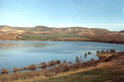
2 Chott Ech Chergui.02/02/01; Saïda; 855,500 ha; 34º27 N 000º50 E. The second largest chott in North Africa, after the Chott Djerid in Tunisia: an extensive closed depression containing permanent and seasonal saline, brackish, and freshwater lakes and pools, as well as hot springs. The site is representative of the Mediterranean region in the diversity of habitats which are included, from steppe areas that are always green to the surroundings of the chott and the "sebkhas" which are completely without vegetation, as well as purely aquatic lake and marsh vegetation. Many threatened and vulnerable plant species are present, as well as at least two vulnerable species of Anatidae, and it is an important nesting and wintering site for several species of migratory waterbirds. Human uses include agriculture, and raising of livestock, particularly sheep and camels; the thermal springs offer possibilities for tourism. Overgrazing, poaching, desertification, and deforestation for firewood are seen as potential threats. Ramsar site no


3 See more of Chott Ech Chergui here. Chott El Hodna.02/02/01; M Sila, Batna; 362,000 ha; 35º18 N 004º40 E. Part of a series of chotts created by waters descending from the Atlas Tellien to the north and the Saharan Atlas to the south, typical landscape of vegetated Maghreb steppe with seasonal brackish and saline lakes, pools, and marshes and freshwater springs. The peripheral zone of chott, characterized by wadis and oases, surrounds the central zone of the sebkha, with a complete absence of vegetation. The site is important for a number of endangered species, notably gazelles, bustards, and marbled teal, and also qualifies for the List for its significance as habitat for indigenous fish species. Human uses include pastoralism and salt extraction, and the area is home to Roman ruins and other archaeological remains. Potential threats include pollution from urban and industrial waste water; over-exploitation of water, salt, sand, and soil; over-grazing and deforestation for firewood. Ramsar site no Chott Merrouane et Oued Khrouf.02/02/01; El Oued; 337,700 ha; 33º55 N 006º10 E. The chott is characterized by saline ponds and lakes that are permanent by virtue of the flow of the Wadi Khrouf, containing continuous runoff of

, salt extraction, and recreational hunting and fishing.")
4 excess irrigation for cultivation of palms and waste water from neighboring communes. Located in a region of arid steppe, the site is internationally important for passing migratory birds, some of which are classed by IUCN as vulnerable, as well as for several indigenous fish species. Other wetland types listed as present include freshwater springs/oases, irrigation channels, salt exploitation sites, and drainage canals. Human uses include livestock raising (principally sheep), salt extraction, and recreational hunting and fishing. Water pollution and over-grazing are seen as potential threats to the ecological character of the site. Ramsar site no Complexe de zones humides de la plaine de Guerbes-Sanhadja.02/02/01; Skikda, El Tarf; 42,100 ha; 36º53 N 007º16 E. Planned Regional Nature Park. A large coastal plain between the hills of Skikda and the forested massif of Chetaïbi near Cap de Fer, including the delta of the Wadi El Kébir. Amongst the characteristic dunes can be found a multitude of depressions and valleys forming lakes and "garâas" (marshes) from a few to several dozen hectares in area, on a plain that is described as a "bioclimatic crossroads" including sub-saharan and European as well as Mediterranean characteristics. In addition to its significant biological diversity, the site is important for migratory birds (especially as a nesting place for Oxyura leucocephala and Aythya nyroca) and fish and eels. Human uses include agriculture (especially tomatoes and melons) and grazing; potential threats include unmanaged agricultural expansion and runoff and waste-water from upstream villages. Ramsar site no
 in the center of a limestone Saharan plateau characterized by intermittent streams, lakes, and marshes, freshwater springs, and subterranean karst hydrological systems.")

5 La Vallée d Iherir. 02/02/01; Illizi; 6,500 ha; 25º24 N 008º25 E. Parc National du Tassili; UNESCO World Heritage site. A high valley (1100m-1400m) in the center of a limestone Saharan plateau characterized by intermittent streams, lakes, and marshes, freshwater springs, and subterranean karst hydrological systems. The isolated nature of the site has led to remarkable evolutionary phenomena, described as "at the same time, a laboratory and a museum of the process of evolution", particularly for species which have been best able to resist the desertification of the area, such as lizards, serpents, and four species of fish. Basic palm and fig culture is practiced near the site by the Tuareg community on terraces above the valley floor, and some raising of vegetables takes place in areas shaded by trees. The rocky mountain walls bear rich pictorial evidence of some of the first human inhabitants of the Sahara; this has encouraged fairly significant tourism, which, however, was drastically diminished between 1992 and 2000 and is only recently beginning to recover. Ramsar site no


6 Les Gueltates d Issakarassene.02/02/01; Tamanrasset; 35,100 ha; 22º25 N 005º45 E. Parc National de L Ahaggar. A "guelta" is a wetland type specific to the mountains of Haggar and Tassili, a kind of rocky basin or "crater-hole" hollowed out of the riverbed. Either permanent or intermittent, gueltates are often found between 1,000 and 2,000 meters altitude, and their depth may vary between 4 and 15 meters. Permanent gueltates play a very important role in the lives of Tuareg nomads of the region and their livestock, as well as serving as stopover for migratory birds crossing the Sahara. Issakarassene, in the Haggar mountains, is a permanent wetland of a type that does not yet figure in the Ramsar classification system, fed both by permanent underground sources and sometimes by torrential rainstorms. The site supports a concentration of the last remaining examples of formerly thriving flora and fauna, of which several wetland-dependent species have been able to develop various forms of adaptation that have permitted them thus far to survive the gradual process of aridification of the


7 Sahara, including fish species endemic to the desert the cheetah Acinonyx jubatus and the gazelle Gazella dorcas are both classed as vulnerable by IUCN. The rocky, "lunar" landscape supports few human uses except as a source of water for nomads and their animals, and no significant threats are foreseen, except eventually a possible increase in tourism. Ramsar site no Marais de la Macta. 02/02/01; Mascara, Mostaganem, Oran; 44,500 ha; 35º41 N 000º10 W. In a triangular depression separated from the Gulf of Arzew near Oran by a dune cordon, a complex of open water, marsh, and more or less humid steppe some nine miles inland, supplied by three permanent wadis. The site represents a wetland type that is rare in North Africa in the diversity of habitats it contains, most notably "sansouires" salt marshes that recall the Camargue in France. A large biodiversity is found there, including a great variety of halophilic vegetation, as well as numerous invertebrates and fish. The wetland is important for both local residents and nomads, particular during dry periods, for pasturage for their cattle and their sheep, respectively. Ramsar site no Oasis de Ouled Saïd.02/02/01; Adrar; 25,400 ha; 29º24 N 000º18 E. A rare human-made wetland created on the vestiges of a "fossil" wadi; over time, the diminution of the water in the wadi required the construction of a "fouggara", an ingenious system for the capture and distribution of groundwater. The water, distributed in little open-air channels within the tradition of an ancestral social organization, is shared out equitably to individual gardens for the cultivation of palms, mainly, with some cereals and fruits as well. The site is also important for migratory birds and includes important archaelogical remains of an original Arab/Muslim architecture of "Ksars" (fortresses) from the 14 th century. The fouggara method in use at Ouled Saïd is said to be an outstanding illustration of the Ramsar wise use principle, but because the oasis requires constant human maintenance and is slowly but surely being overtaken by the sand, Algerian authorities have requested at the time of designation that the site be placed on the Montreux Record. Ramsar
 and associated village, with palm cultivation below.")
, probably the first human-made subterranean hydrological system in the Ramsar List.")
8 site no Oasis de Tamantit et Sid Ahmed Timmi.02/02/01; Adrar; 95,700 ha; 27º45 N 000º15 E. National Heritage Monument. A succession of several oases, each overlooked by an ancient Ksar (fortress) and associated village, with palm cultivation below. Residents practice the traditional method of distribution of water for irrigation by means of "fouggara", a human-made hydraulic system said to have originated in Persia and been introduced to the Maghreb during the Arab conquest of the 7 th century. The site is classed as, among others, wetland type Zk(c), probably the first human-made subterranean hydrological system in the Ramsar List. The isolation of the site and the hostile environmental conditions have favored the evolution of a very interesting biological diversity. Depletion of groundwater reserves, caused in part by increasing use of modern agricultural pump-irrigation and monoculture, is seen as a potential threat, as is continuous advance of the "ergs" or wind-driven sand dunes. There is some tourism, with pedestrian and camel-back tours of the Ksars and fouggara, and local crafts are in considerable demand. Ramsar site no


9 Sebkha d Oran.02/02/01; Oran; 56,870 ha; 35º22 N 000º48 W. A large endorrheic depression of tectonic origin, with a seasonal saline lake and flats characterized by halophilic vegetation. The site surpasses the 1% threshold for pink flamingos and shelduck (Criterion 6). Ramsar site no
10 Source URL:
Intermediate report. Letter of agreement FAO - GCB/RAB/013/ITA
 Treated waste water for sustainable production of valuable biomass, soil and water quality improvement and combating desertification in Algeria and Tunisia Letter of agreement FAO - GCB/RAB/013/ITA Intermediate
سبل تفعيل تنفيذ ا تفاقية الا راضى الرطبة فى المنطقة العربية
 CONVENTION ON WETLANDS "RAMSAR" AND THE ARAB REGION سبل تفعيل تنفيذ ا تفاقية الا راضى الرطبة فى المنطقة العربية "رامسار" National Institute of Oceanography and Fisheries WETLANDS SERVICES AND PRODUCTS
Chapter 17. North Africa, Southwest Asia and Central Asia
 Chapter 17 North Africa, Southwest Asia and Central Asia Chapter Objectives Describe the major landforms and natural resources of North Africa, Southwest Asia, and Central Asia. Discuss the climate and
Congo names four large Ramsar sites
 Congo names four large Ramsar sites 1 February 2008 Congo The Republic of Congo designates four sites on World Wetlands Day 2008 The Direction Générale de l'environnement of the Republic of Congo has taken
SS7G1 The student will locate selected features of Africa.
 Standards SS7G1 The student will locate selected features of Africa. a. Locate on a world and regional political-physical map: the Sahara, Sahel, savanna, tropical rain forest, Congo River, Niger River,
GASCO Abr Seina Onshore Gas Pipeline
 4.0 Existing Environment 4.1 INTRODUCTION The route of Abr Seina pipeline 32, 111 km, starts from El Tina Shark (long. 31 o 1 27.7 lat. 32 o 20 47.4 ) to El Arish, northern Sinai. A general survey was
GEOGRAPHY AND HISTORY
 GEOGRAPHY AND HISTORY YEAR 1, PART 1 www.vicensvives.es Contents 01 Our planet Earth 02 The representation of the Earth: maps 03 The Earth s relief 04 Rivers and seas 05 Weather and climate 06 Climates
Biosphere Reserve of IRAN. Mehrasa Mehrdadi Department of Environment of IRAN
 Biosphere Reserve of IRAN Mehrasa Mehrdadi Department of Environment of IRAN Biodiversity in Iran Comprises a land area of 1.64 million km² The average altitude is over 1200 m, Is bordered by Turkmenistan,
EUROPEAN COMMISSION DG XI.D.2. COUNCIL DIRECTIVE 79/409/EEC on the conservation of wild birds. and
 EUROPEAN COMMISSION DG XI.D.2 COUNCIL DIRECTIVE 79/409/EEC on the conservation of wild birds and COUNCIL DIRECTIVE 92/43/EEC on the conservation of natural habitats and of wild fauna and flora STANDARD
Africa: Physical geography
 Africa: Physical geography By National Geographic Society, adapted by Newsela staff on 09.15.17 Word Count 1,279 Level 1040L African elephants roam the savannas, which cover almost half of the African
Brain Wrinkles. Africa: The impact of location, climate, & physical characteristics on where people live, the type of work they do, & how they travel
 Africa: The impact of location, climate, & physical characteristics on where people live, the type of work they do, & how they travel STANDARDS: SS7G3 The student will explain the impact of location, climate,
Chapter 16 ~ Eastern Mediterranean
 Chapter 16 ~ Eastern Mediterranean Physical Geography of the Eastern Mediterranean Landforms This area is known as the Levant and includes Syria, Jordan, Lebanon, Israel, and the Palestinian territories.
Forms of Natural Protection in Greece
 Forms of Natural Protection in Greece 105 th Primary School of Thessaloniki NATIONAL PARKS AND PROTECTED AREAS The irregular and constantly increasing human intervention in nature and the relentless exploitation
Geography of Qatar. Contents. State Borders. al-khor, Qatar. Photo Flickr. Loading index...
 Geography of Qatar al-khor, Qatar. Photo Flickr Contents Loading index... State Borders The small (sub)peninsula of Qatar is about 160 kilometres in length and between 55 and 90 kilometres in width. Its
STUDY GUIDE. The Land. Chapter 17, Section 1. There are frequent earthquakes in the region. Petroleum is a major export in the region.
 For use with textbook pages 421 426. The Land Terms to Know alluvial soil A rich soil made up of sand and mud deposited by flowing water (page 423) wadi A streambed that remains dry until a heavy rain
IMPACTS OF THE RECENT TSUNAMI ON THE BUNDALA NATIONAL PARK THE FIRST RAMSAR WETLAND IN SRI LANKA
 IMPACTS OF THE RECENT TSUNAMI ON THE BUNDALA NATIONAL PARK THE FIRST RAMSAR WETLAND IN SRI LANKA by C.N.B. Bambaradeniya, IUCN The World Conservation Union, Sri Lanka Country Office (Email: cnb@iucnsl.org)
UNIT 5 AFRICA PHYSICAL GEOGRAPHY SG 1 - PART II
 UNIT 5 AFRICA PHYSICAL GEOGRAPHY SG 1 - PART II III. CLIMATE & VEGETATION A. The four main climate zones are tropical wet, tropical wet/dry (split into monsoon & savanna), semiarid, and arid. Other climate
Chapter 16 ~ Eastern Mediterranean
 Chapter 16 ~ Eastern Mediterranean Physical Geography of the Eastern Mediterranean Landforms This area is known as the Levant and includes Syria, Jordan, Lebanon, Israel, and the Palestinian territories.
 AGREEMENT Between Director of the Białowieża National Park, based in Białowieża (Poland) and Director of the National Park Bialowieża Forest, based in Kamieniuki (Belarus) and Head Forester of the Białowieża
Special animals of the caves of the Kinabatangan need protection!
 Special animals of the caves of the Kinabatangan need protection! Limestone and caves Although limestone occupies only a very small fraction of the land area, it harbours disproportionate biodiversity.
Lake Ohrid. our shared responsibilities and benefits. Protecting
 Towards strengthened governance of the shared transboundary natural and cultural heritage of the Lake Ohrid region Protecting Lake Ohrid region our shared responsibilities and benefits This publication
North Africa. Chapter 25. Chapter 25, Section
 Chapter 25, Section World Geography Chapter 25 North Africa Copyright 2003 by Pearson Education, Inc., publishing as Prentice Hall, Upper Saddle River, NJ. All rights reserved. Chapter 25, Section World
Terrestrial Protected Area Nomination: Central Mangrove Wetland South-West, Grand Cayman
 Terrestrial Protected Area Nomination: Central Mangrove Wetland South-West, Grand Cayman The attached nomination, proposing that a parcel of land in the Central Mangrove Wetland be made a Protected Area
photos Department of Environment and Conservation Biodiversity Conservation
 photos Department of Environment and Conservation Biodiversity Conservation EcoEducation - making the connections to biodiversity conservation Do you consider experiential learning of biodiversity in the
5 proposed wetland sites
 PROPOSED WETLAND SITES OF VIETNAM Hoang Van Thang, PhD. 5 proposed wetland sites 1. Lak Lake 2. Lo Go Sa Mat 3. Tram Chim 4. UMi Minh hthuong 5. Mui Ca Mau Lak Lake Coordinates: 12o24 22 12o26 25 N 108o09
THE STATUS OF DORCAS GAZELLE IN ETHIOPIA
 THE STATUS OF DORCAS GAZELLE IN ETHIOPIA Paper presented in the second workshop on the conservation and restoration of Sahelo-Saharan Antelopes. 1-5 May 2003 by Mohammed Ali and Ababu Ange Zeleke May /
INTRODUCTION Background: Definitions Wetlands in Egypt Threats to Wetlands Wetland Services
 INTRODUCTION Background: Definitions Wetlands in Egypt Threats to Wetlands Wetland Services NATIONAL STRATEGY Mission: Goal Guiding Principles Objectives and Bases of Action Actions to Achieve Objectives
Boatswain bay biodiversity reserve
 Boatswain bay biodiversity reserve March 2003 1 1. Plan and description 1.1. Geographic location, boundaries and dimensions The plan of the proposed Boatswain bay biodiversity reserve and its location
Just how big is Africa?
 The United States China India The United Kingdom Portugal Spain France Belgium Germany The Netherlands Switzerland Italy Eastern Europe Japan 11.7 million sq. miles Just how big is Africa? Chapter 18 Section
Geography (cont) Sorghum, rice, millet, rice, wheat and corn grown on savannahs. Not just one big plain though mountainous and swampy areas too
 Sorghum, rice, millet, rice, wheat and corn grown on savannahs. Not just one big plain though mountainous and swampy areas too") Geography & Society in Africa: 500 BCE-900 CE Geography Around 5000 miles wide and long Various climates, jungles, snow-capped mountains, deserts and rain-soaked areas. 40% desert - largely uninhabitable
Geography & Society in Africa: 500 BCE-900 CE Geography Around 5000 miles wide and long Various climates, jungles, snow-capped mountains, deserts and rain-soaked areas. 40% desert - largely uninhabitable
Appendix A Geographic and Geologic Terms Connected With Egypt
 Appendix A Geographic and Geologic Terms Connected With Egypt Egypt Official name is the Arab Republic of Egypt. Total area is 1,002,450 km 2, which makes Egypt the 29th largest country in the world. Only
New Ramsar sites for Poland
 New Ramsar sites for Poland 31 October 2005 Poland Poland designates five new Wetlands of International Importance The Secretariat is pleased to announce that the Government of Poland has designated five
Creation of a Community-managed Biodiversity Park in the Saloum Delta of Senegal. Voré Gana Seck Director GREEN Senegal for People, Land, Ocean
 Creation of a Community-managed Biodiversity Park in the Saloum Delta of Senegal Voré Gana Seck Director GREEN Senegal for People, Land, Ocean Rationale for the Creation of the Biodiversity Park F In line
Middle East Part I Notes
 Middle East Part I Notes What do we already know about the Middle East? What do we already know about the Middle East? Pre-Test 1. T/F- The U.S. is currently fighting a war in the Middle East. 2. Which
Portugal designates five varied Ramsar sites
 Portugal designates five varied Ramsar sites 11 mai 2006 Portugal Interesting new Ramsar sites in Portugal The Secretariat is very pleased to announce that the government of Portugal has designated five
What Is An Ecoregion?
 Ecoregions of Texas What Is An Ecoregion? Ecoregion a major ecosystem with distinctive geography, characteristic plants and animals, and ecosystems that receives uniform solar radiation and moisture Sometimes
Wetlands Reservoirs of Biodiversity. Billy McCord, SCDNR
 Wetlands Reservoirs of Biodiversity Billy McCord, SCDNR Estuaries Tidal Deepwater Intertidal Salt Marsh Tidal Riverine Fresh & Brackish Deepwater Tidal Emergent Marsh Freshwater Riverine Seasonally Flooded
UNIT 5 PHYSICAL GEOGRAPHY SG 1 - PART I
 UNIT 5 PHYSICAL GEOGRAPHY SG 1 - PART I Africa is HUGE! I. LANDFORMS A. Plateaus - an area of relatively level high ground. 1. Africa s interior is dominated by series of plateaus and elevated basins such
Drin River Basin: the blue heart of the Balkans... 3
 Drin River Basin The blue heart of the Balkans 1 The Mediterranean Information Office for Environment, Culture and Sustainable Development (MIO ECSDE) is a non profit Federation of 126 Mediterranean NGOs
Brief Description of Northern the West Bank, Palestine Prepared by: Dr. Ahmed Ghodieh Department of Geography An-Najah National University Nablus,
 Brief Description of Northern the West Bank, Palestine Prepared by: Dr. Ahmed Ghodieh Department of Geography An-Najah National University Nablus, Palestine Brief Description of Northern the West Bank
The Values of the Tasmanian Wilderness World Heritage
 The Values of the Tasmanian Wilderness World Heritage Area The natural and cultural values that have resulted in the TWWHA being reserved as conservation land and inscribed on the World Heritage List are:
CONVENTION ON INTERNATIONAL TRADE IN ENDANGERED SPECIES OF WILD FAUNA AND FLORA
 CoP14 Prop. 12 CONVENTION ON INTERNATIONAL TRADE IN ENDANGERED SPECIES OF WILD FAUNA AND FLORA Fourteenth meeting of the Conference of the Parties The Hague (Netherlands), 3-15 June 2007 CONSIDERATION
World Heritage Site 1. World Heritage Site 2
 World Heritage Site 1 These massive waterfalls are located on the border of two African countries. The native name for the falls translates to Smoke that Thunders. The mist from these thundering river
Case Study: 1. The Clarence River Catchment
 Case Study: 1. The Clarence River Catchment The NSW coastline is a great natural asset, making an enormous contribution to the economy. The resources of coastal catchments such as the Clarence River Catchment,
2019 EXCURSION THE ARDECHE GORGES
 The following shore excursions are offered during the cruise. The three letter code for our Rhone cruise is LMX so all the excursions indicated by these three letters will be offered during the cruise.
Belarus seminar on transboundary wetland sites
 Belarus seminar on transboundary wetland sites 12 May 2004 Belarus Transboundary Ramsar Sites On 28-29 April 2004, a seminar on transboundary wetland sites took place in the town of Lida (Republic of Belarus),
Ceremonies for Albania's Butrint
 Ceremonies for Albania's Butrint 18 July 2003 Albania The Ramsar Site diploma was presented to the Albanian authorities on 14 July 2003 during an official ceremony for the designation of Albania's second
Physical characteristics and biomes:
 Physical characteristics and biomes: Sahel region, bordering Sahara Characteristics Area suffers from lack of rainfall, over grazing, which causes loss of vegetation and loss of inhabitable areas causing
PARTICULARITIES AND THREATS ON THE BIODIVERSITY FROM CROATIA
 PARTICULARITIES AND THREATS ON THE BIODIVERSITY FROM CROATIA Associate Professor Ph.D. Andreea BĂLTĂREŢU Dimitrie Cantemir Christian University, Faculty of Touristic and Commercial Management, Romania
SUPPORT TO WATER RESOURCES MANAGEMENT IN THE DRINA RIVER BASIN DRAFT ROOF REPORT INTRODUCTION AND GENERAL APPROACH
 SUPPORT TO WATER RESOURCES MANAGEMENT IN THE DRINA RIVER BASIN DRAFT ROOF REPORT INTRODUCTION AND GENERAL APPROACH Nadja Zeleznik, REC Public Concultation Beograd, Serbia, 4 July 2017 1 1. Introduction
SAHHA SAHARA CAMEL TREKS AND SOUTH TUNISIA TOURS EcoTourism
 SAHHA SAHARA CAMEL TREKS AND SOUTH TUNISIA TOURS EcoTourism SAHARA ADVENTURE & Taste of South Tunisia (3 Days/2 Nights) (Beginning and ending in Djerba) DAY 1: We will pick you up in Djerba, either at
Chapter 7: The Geography and Settlement of Egypt, Kush, and Canaan
 Chapter 7: The Geography and Settlement of Egypt, Kush, and Canaan Learning Target: I can explain how geography affected early settlement in Egypt, Kush, and Canaan. Ancient Egypt and the Middle East Can
ECOREGIONAL ASSESSMENT EQUATORIAL PACIFIC EXECUTIVE SUMMARY
 ECOREGIONAL ASSESSMENT EQUATORIAL PACIFIC The Nature Conservancy, Fundación Agua, EcoCiencia, Fundación Jatun Sacha, CDC Ecuador, CDC UNALM 2004. Portafolio de Sitios Prioritarios para la Conservación
Region 1 Piney Woods
 Region 1 Piney Woods Piney Woods 1. This ecoregion is found in East Texas. 2. Climate: average annual rainfall of 36 to 50 inches is fairly uniformly distributed throughout the year, and humidity and temperatures
Prosjekt Lesina Mediteranean sea Coastal lagoon
 Prosjekt Lesina Mediteranean sea Coastal lagoon PERIODE 2012-2015 LAND The Lesina Lagoon, alternatively known as the Lake of Lesina due to its small and previously fleeting hydrological connection to the
Draft Resolution on wetlands in polar and subpolar regions
 RAMSAR CONVENTION ON WETLANDS 54th Meeting of the Standing Committee Gland, Switzerland, 23 27 April 2018 Submitted by Sweden Draft Resolution on wetlands in polar and subpolar regions SC54-Com.15 (21.14)
Chapter 7 Geography and the Early Settlement of Egypt, Kush, and Canaan
 Chapter 7 Geography and the Early Settlement of Egypt, Kush, and Canaan How did geography affect early settlement in Egypt, Kush, and Canaan? Section 7.1 - Introduction RF/NASA//Corbis This satellite photograph
The Vjosa River in Albania
 The Vjosa River in Albania Europe s Wild jewel - beautiful, unknown and threatened The extensive braided river section near Tepelena would drown in a reservoir of the future Kalivaç dam. (Romy Durst) Major
Unit 9 The Middle East SG 1 - Physical Geography, Population & Demographics
 Unit 9 The Middle East SG 1 - Physical Geography, Population & Demographics I. Physical Geography A. The Middle East includes southwestern Asia and North Africa. 1. The name is Eurocentric. Middle East
Tourism and Wetlands
 CONVENTION ON WETLANDS (Ramsar, Iran, 1971) 43 rd Meeting of the Standing Committee Gland, Switzerland, 31 October 4 November 2011 DOC. SC43-27 Tourism and Wetlands Action requested. The Standing Committee
Protection of Ulcinj Saline
 Strasbourg, 25 March 2015 T-PVS/Files (2015) 21 [files21e_2015.docx] CONVENTION ON THE CONSERVATION OF EUROPEAN WILDLIFE AND NATURAL HABITATS Standing Committee 35 th meeting Strasbourg, 1-4 December 2015
Africa s. Presentation, Graphic Organizers, & Activities
 Africa s Presentation, Graphic Organizers, & Activities STANDARDS: SS7G1 Locate selected features of Africa. a. Locate on a world and regional political-physical map: Sahara, Sahel, savanna, tropical rain
Title/Name of the area: Chwaka Bay, Zanzibar
 Title/Name of the area: Chwaka Bay, Zanzibar Presented by: Dr. Charles Lugomela, Ag. Head, Department of Aquatic Sciences and Fisheries, University of Dar es Salaam, P.O. Box 35064 Dar es Salaam, Tanzania
Data on Albanian Biodiversity and Mapping
 Data on Albanian Biodiversity and Mapping Petrit Hoda University of Tirana, Botanical Garden Albana Zotaj Academy of Sciences Institute of Geographical Studies Country profile Area 28748 km2 Population
Wetland of Lakes Koronia and Volvi, by Themis Nasopoulou Ramsar Wetland of Lakes Koronia and Volvi
 Preliminary hour by- hour Schedule By Themis Nasopoulou Ecoguide-Journalist MSc Biological Diversity E-mail: nasthem1@hotmail.com Mob.tel.: 0030-6937122299 Ramsar Wetland of Lakes Koronia and Volvi Litohoro
Brador hills biodiversity reserve
 Brador hills biodiversity reserve September 2003 1. Plan and description 1.1. Geographic location, boundaries and dimensions The plan of the proposed Brador hills biodiversity reserve and its location
LATIN AMERICA / CARIBBEAN COIBA NATIONAL PARK PANAMA
 LATIN AMERICA / CARIBBEAN COIBA NATIONAL PARK PANAMA WORLD HERITAGE NOMINATION IUCN TECHNICAL EVALUATION COIBA NATIONAL PARK (PANAMA) ID Nº 1138 Bis Background note: Coiba National Park was nominated for
Crete Study Site Description
 Crete Study Site Description 1. Location Crete (the largest island of Greece) is located in the south part of Greece covering an area of 8.335 km 2 or 6.3% of the Greek territory, including the surrounding
Chapter 20. The Physical Geography of Africa South of the Sahara
 Chapter 20 The Physical Geography of Africa South of the Sahara Chapter Objectives Identify the major landforms, water systems, and natural resources of Africa south of the Sahara. Describe the relationship
Caring for our Lake our Future
 Caring for our Lake our Future The Management Plan for Lake Shkodra Nature Park A Summary Photo Tonin Macaj This brochure is partly funded by the European Union Lake Shkodra: plentiful nature, long human
1. What are the problems with tourism in Jordan? 2. How is sustainable tourism being encouraged?
 Jordan 1. What are the problems with tourism in Jordan? 2. How is sustainable tourism being encouraged? TAB 1 QUESTION - What are the problems with tourism in Jordan? Before looking into tourism in Jordan
Current conditions. Guatemala's Maya Biosphere Reserve. No clear idea of speed of deforestation. Deforestion by pollen analysis
 Current conditions Most obvious human transformation is cutting of forests Guatemala's Maya Biosphere Reserve An Eco-Friendly Adventure Along the Maya Trails Key ecological roles: repository for biodiversity
Draft Resolution on wetlands in polar and subpolar regions
 RAMSAR CONVENTION ON WETLANDS 54th Meeting of the Standing Committee Gland, Switzerland, 23 27 April 2018 Submitted by Sweden Draft Resolution on wetlands in polar and subpolar regions Doc. SC54-21.14
Chapter 7. Geography and the Early Settlement of Egypt, Kush, and Canaan
 Chapter 7 Geography and the Early Settlement of Egypt, Kush, and Canaan Chapter 7 Geography and the Early Settlement of Egypt, Kush, and Canaan How did geography affect early in Egypt Kush, and Canaan?
Global Sustainable Tourism Destinations Criteria
 Global Sustainable Tourism Destinations Criteria Draft destination level Global Sustainable Tourism Criteria as proposed after Destinations and International Standards joint working group meeting and follow-up
AFRICAN PHYSICAL GEOGRAPHY
 AFRICAN PHYSICAL GEOGRAPHY Here are some factoids about Africa: world s second largest continent (11,700,000 miles). Home to 52 countries, 1,000 languages, 800 million people. 10% of the world s population
The Ramsar Convention
 The Ramsar Convention a modern successstory story for nature conservation by Tobias Salathé Ramsar Convention Secretariat www.ramsar.org Ramsar Site Cerknica lake - Slovenia 1960s : dissappearinghabitats
The Pilcomayo River Basin Argentina
 The Pilcomayo River Basin Argentina Yangareko ( Janis Alcorn, Alejo Zarzycki, Alonzo Zarzycki, Luis Maria de la Cruz) Governance and Ecosystems Management for the CONservation of BIOdiversity www.gemconbio.eu
Towards Strengthened Governance of the Shared Trans-boundary Natural and Cultural Heritage of the Lake Ohrid Region
 Towards Strengthened Governance of the Shared Trans-boundary Natural and Cultural Heritage of the Lake Ohrid Region Zhulieta Harasani, Albania OCTOBER 2015 THE SHARED TRANSBOUNDARY NATURAL AND CULTURAL
An NPS Wetland of International Significance!
 An NPS Wetland of International Significance! A World Class Tourism Destination Linda Friar Chief of Public Affairs 305-242-7714 Linda_Friar@nps.gov The Everglades - International Recognition as a special
10 Life in the Deserts
 10 Life in the Deserts In Chapter 5, you have seen that water means life to plants, animals and people. It is difficult for anyone to live in places where there is no water to drink, where there is no
SELF-ASSESSMENT CHECKLIST
 Tourism and Mountains A Practical Guide to Managing the Environmental and Social Impacts of Mountain Tours Using this Self-Assessment Checklist This checklist has been developed to help mountain-based
Hydrology of Yemen. Dr. Abdulla Noaman
 Hydrology of Yemen Dr. Abdulla Noaman INTRODUCTION Location and General Topography Yemen is located on the south of the Arabian Peninsula, between latitude 12 and 20 north and longitude 41 and 54east,
Ancient Egypt and the Near East
 *O*»f ' i ft Ancient Egypt and the Near East Chapter 7 Chapter 8 Chapter 9 Geography and the Early Settlement of Egypt, Kush, and Canaan The Ancient Egyptian P h a r a o h s Daily Life in Ancient Egypt
Quintessential Rare Plant Site Protected, Forever Celebrating the New Wilsons Lake Conservation Lands
 Quintessential Rare Plant Site Protected, Forever Celebrating the New Wilsons Lake Conservation Lands A hotspot for Canadian endangered species conservation has been protected, forever, in Nova Scotia.
Hawke s Bay Regional Parks Network. Pekapeka Regional Park Individual Park Plan
 Hawke s Bay Regional Parks Network Pekapeka Regional Park Individual Park Plan 2015-2024 Hawke s Bay Regional Council 159 Dalton Street Private Bag 6006 Napier 4110 Hawke s Bay New Zealand Telephone: 0800
Information on Ecological and Biological Significant Marine Areas in Albania
 Information on Ecological and Biological Significant Marine Areas in Albania The report is assembled from the draft strategic plan for marine and coastal protected areas in Albania, supported by the GEF-UNDP
Remeandring of river Lemme where crossing a fen, Jura Plateau
 Remeandring of river Lemme where crossing a fen, Jura Plateau Le pôle relais tourbières Pôle-relais tourbières (French Mire Resource Centre) It was created in 2001 during the 1st National Action Plan for
2012. Proceedings of the 11 European Geoparks Conference. AGA Associação Geoparque Arouca, Arouca, 5-6.
 References to this volume It is suggested that either the following alternatives should be used for future bibliographic references to the whole or part this volume: th Sá, A.A., Rocha, D., Paz, A. & Correia,
NAMIBIA IN FLY 7 DAYS /6 NIGHTS
 DAY 1 : WINDHOEK Namib desert Arrival at International airport where you will meet our local representative You will receive your travel documents and meet the pilot Departure with a charter flight Cessna
147 (BIS): KAKADU NATIONAL PARK (AUSTRALIA)
: KAKADU NATIONAL PARK (AUSTRALIA)") WORLD HERITAGE NOMINATION - IUCN SUMMARY 147 (BIS): KAKADU NATIONAL PARK (AUSTRALIA) Summary prepared by WCMCIIUCN (March 1992) based on the original nomination submitted by the Government of Australia.
WORLD HERITAGE NOMINATION - IUCN SUMMARY 147 (BIS): KAKADU NATIONAL PARK (AUSTRALIA) Summary prepared by WCMCIIUCN (March 1992) based on the original nomination submitted by the Government of Australia.
Europe s wild jewel - The Vjosa River in Albania
 SAVE THE BLUE HEART OF EUROPE THE BALKAN RIVERS Europe s wild jewel - The Vjosa River in Albania BEAUTIFUL, UNKNOWN AND THREATENED The extensive braided river section near Tepelena would drown in a reservoir
AGRITECH th December 2017, Podgorica
 AGRITECH 2017 06-07 th December 2017, Podgorica AGRI Potentials of Capital City Podgorica Vladimir Pavićević, MSc Deputy Secretary Secretariat for labor, youth and social care Main characteristics of Montenegro
Ecohydrology of karst poljes and their vulnerability
 Ecohydrology of karst poljes and their vulnerability Prof. emeritus O. Bonacci Faculty of Civil Engineering, Architecture and Geodesy, Split University, 21000 Split, Matice hrvatske 15, Croatia E-mail:
Dr. Lkhagvasuren Badamjav Leading Scientist, Institute of Biology Mongolian Academy of Sciences
 Transboundary landscape cooperation in the Altay-Sayan region: experiences and lessons learnt Dr. Lkhagvasuren Badamjav Leading Scientist, Institute of Biology Mongolian Academy of Sciences Stakeholder
8 Historic and Cultural Sites Inscribed in UNESCO World Heritage List
 8 Historic and Cultural Sites Inscribed in UNESCO World Heritage List Meidane Emam (Naghshe Jahan), Isfahan (1979) Built by Shah Abbas I the Great at the beginning of the 17th century, and bordered on
Planning a National Aquatic Area Network (NAAN) for Conservation & Management of Rare, Threatened & Endangered Wetland Biodiversity
 for Conservation & Management of Rare, Threatened & Endangered Wetland Biodiversity") Planning a National Aquatic Area Network (NAAN) for Conservation & Management of Rare, Threatened & Endangered Wetland Biodiversity B.C. Choudhury bcc@wii.gov.in Keynote Presentation on Biodiversity &
Planning a National Aquatic Area Network (NAAN) for Conservation & Management of Rare, Threatened & Endangered Wetland Biodiversity B.C. Choudhury bcc@wii.gov.in Keynote Presentation on Biodiversity &
Biodiversity and Protected Areas-- Ukraine
 Biodiversity and Protected Areas-- Ukraine EarthTrends Country Profiles Ukraine Europe World Total Land Area (000 ha) 60,370 2,301,873 13,328,979 Protected Areas Extent of Protected Areas by IUCN Category
Draft Resolution on wetlands in polar and subpolar regions
 RAMSAR CONVENTION ON WETLANDS 54th Meeting of the Standing Committee Gland, Switzerland, 23 27 April 2018 Submitted by Sweden Draft Resolution on wetlands in polar and subpolar regions SC54-Com.15 (21.14)
WORLD HERITAGE NOMINATION - IUCN TECHNICAL EVALUATION ST. PAUL SUBTERRANEAN RIVER NATIONAL PARK (PHILIPPINES)
") WORLD HERITAGE NOMINATION - IUCN TECHNICAL EVALUATION ST. PAUL SUBTERRANEAN RIVER NATIONAL PARK (PHILIPPINES) 1. DOCUMENTATION i) IUCN/WCMC Data Sheet: (4 references). ii) iii) Additional Literature Consulted:
WORLD HERITAGE NOMINATION - IUCN TECHNICAL EVALUATION ST. PAUL SUBTERRANEAN RIVER NATIONAL PARK (PHILIPPINES) 1. DOCUMENTATION i) IUCN/WCMC Data Sheet: (4 references). ii) iii) Additional Literature Consulted: