J.M.Alveirinho Dias * R. Gonzalez * Ó. Ferreira * * Universidade do Algarve Faculdade de Ciências do Mar e do Ambiente
|
|
|
- Ethelbert Jenkins
- 5 years ago
- Views:
Transcription
1 J.M.Alveirinho Dias * R. Gonzalez * Ó. Ferreira * * Universidade do Algarve Faculdade de Ciências do Mar e do Ambiente
2 4ª bacia hidrográfica (em área) da Península Ibérica Area: km 2 Comprimento: 810 km
3 4ª bacia hidrográfica (em área) da Península Ibérica Area: km 2 Comprimento: 810 km

4 Discharges Escoamentos extremamente irregulares Relação inter-annual entre os maiores e os menores escoamentos anuais Guadiana - 55 Tejo - 17 Douro - 6 É o rio mais irregular da Península Ibérica
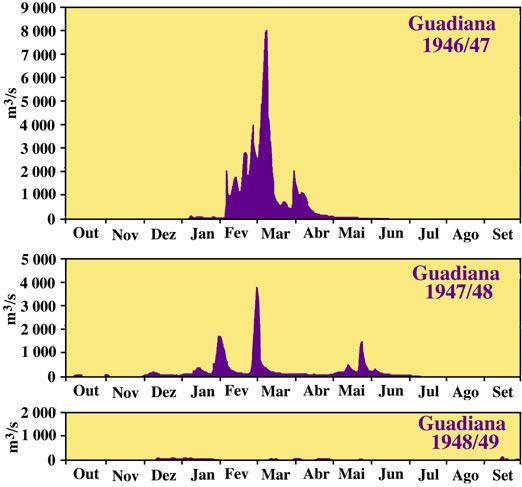
5 Irregularidade caudais

6 Variação da frequência das cheias durante os tempos históricos Ice Age


7 Evolução Evolution during the last 2000 years Present sedimentary distribution and main urbanizations
 At Present is a tipical wave dominated delta (the only oceanic delta in existence in")
8 Delta Accordingly to descriptions by Plato and others, 2000 years ago Guadiana delta had two distributaries The eastern distributary was filled in due to natural evolution and man influences (mainly agriculture) At Present is a tipical wave dominated delta (the only oceanic delta in existence in Portugal)
9 Barra Evolução Sands stemming from river basins are deposited in the vicinity of the river mouths Channels and sand banks can quickly change their location. The O Bril Sand Bank at the mouth of the Guadiana River is a good example

10 O bril Through the interaction of waves, tides, and the outflow of the River, the sand is redistributed either further towards east by the littoral drift, or onto the inner shelf. O Bril bank has been in existence at least since the 16 th century. It reached a minimum extension after the catastrophic flood of January 1876, when it was almost completely flushed out onto the shelf.
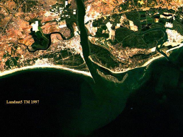
11 Landsat

12 Mining Main man induced factors disturbing sedimentary processes: Mining loose materials dredgings railroad construction slope destabilization Deflorestation mainly for ore pre-processing Wheat Campain first half 20th century deflorestations agriculture Damming electricity production irrigation populations

13 Vapores Number of cargo steam ships per year in the harbour of V.R.Sto. António


14 Fisrt d ams First dams in the Iberian Peninsula built by Romans during 2nd century in the Guadiana River Basin Proserpina Dam in river Pardillas Cornalbo Dam in river Albarregas

15 Dams Sketch map of dams in the Guadiana river basin
16 Erosão / a cumulação The construction of jetties at the Guadiana River Mouth during the period , to stabilize the O bril bank mobility, led to wide coastal accumulation at the western side and strong coastal erosion at the eastern side

17 Armazenamento Storage capacity in the Guadiana River Basin
 high and the Subpolar (Iceland) low Positive NAO Index - Induced by a stronger than usual subtropical high pressure center and a deeper than normal Icelandic low.")
18 NAO The NAO (North Atlantic Oscillation is the dominant mode of winter climate variability in the North Atlantic region The NAO index is based on the surface pressure difference between the Subtropical (Azores) high and the Subpolar (Iceland) low Positive NAO Index - Induced by a stronger than usual subtropical high pressure center and a deeper than normal Icelandic low. - The increased pressure difference results in more and stronger winter storms crossing the Atlantic Ocean on a more northerly track Negative NAO Index - Induced by a weak subtropical high and a weak Icelandic low. - The reduced pressure gradient results in winter storms crossing on a more west-east pathway. -Bring moist air into the Mediterranean and cold air to northern Europe

19 NAO-Guadi total Correlation between winter NAO index and Guadiana discharge

20 NAO-Giadi a ntes Correlation before the dam construction period

21 NAO-G iadi depois Correlation after the dam construction period
")
22 Esc 21 anos Modification of annual discharges (using 21 year windows)

23 Anos humidos Variation in the number of wet and dry years due to river damming
24 Future The Future For the foreseeable future an increase in the positive NAO index through global warming is expected. The immediate consequence of this will be a reduction in the frequency and magnitude of flood events. Additionally the influence of the human factor can only be expected to rise, as water is needed up-river for irrigation, human consumption, and electricity. The consequence will be a further decrease of sand export from the Guadiana River basin to the shelf and the coast, with severe consequences for ecosystems, and the economy.
25 fim
Contents. 1. Introduction. 2. Objectives. 3. Data, Results and Discussion. 4. Final Considerations. Fátima Baptista University of Évora
 Future challenges in animal buildings due to emerging hot climate conditions in Portugal Fátima Baptista University of Évora Contents 1. Introduction 2. Objectives 3. 4. Final Considerations 2 22 et 23
Unit 2: Coastal landforms in Spain. Social Science
 Unit 2: Coastal landforms in Spain Social Science Spanish coastline Spain has 7,880km of coastline between all its territories. It is surrounded by the Atlantic Ocean, Cantabrian Sea and Mediterranean
Water masses and circulation in the North Atlantic
 Ocean and Climate Change, March 30, 2012, Paris Water masses and circulation in the North Atlantic Monika Rhein, Universität Bremen Dagmar Kieke, Christian Mertens, Achim Roessler, and Reiner Steinfeldt
Indian Ocean Small Island States: Indicators of Dangerous Anthropogenic Influences of Climate Change?
 Indian Ocean Small Island States: Indicators of Dangerous Anthropogenic Influences of Climate Change? Prepared for: AGU Fall Meeting San Francisco CA December 5, 2005 Prepared by: Bill Mills Chih-Fang
Chapter 17. North Africa, Southwest Asia and Central Asia
 Chapter 17 North Africa, Southwest Asia and Central Asia Chapter Objectives Describe the major landforms and natural resources of North Africa, Southwest Asia, and Central Asia. Discuss the climate and
CHAPTER 12. South America. Section 1: Natural Environments Section 2: History and Culture Section 3: South America Today. HOLT World Geography
 CHAPTER 12 South America Section 1: Natural Environments Section 2: History and Culture Section 3: South America 1 Section 1 Natural Environments Objectives: What are the major landforms and rivers of
MIÑO O AND LIMIA BASINS
 Miño-Sil MIÑO O AND LIMIA BASINS José Álvarez Díaz Sil River Basin District s s Planning Office, Spain WORKSHOP ON TRANSBOUNDARY WATER RESOURCES BUDAPEST, HUNGARY, 8-10 FEBRUARY 2011 INDEX 1. OVERVIEW
Actual Climatic Conditions in ERB. Online Resource 1 corresponding to:
 Actual Climatic Conditions in ERB. Online Resource 1 corresponding to: Article Title: Climatic Trends and Impact of Climate Change on Agriculture in an Arid Andean Valley. Journal Name: CLIMATIC CHANGE
Typical avalanche problems
 Typical avalanche problems The European Avalanche Warning Services (EAWS) describes five typical avalanche problems or situations as they occur in avalanche terrain. The Utah Avalanche Center (UAC) has
Physical Geography of Europe. Chapters 13-18
 Physical Geography of Europe Chapters 13-18 The British Isles Archipelago made of 6000+ small islands Temperate climate Largest body of fresh water is Loch Ness Mostly rolling hills and large flat lands
The Geological Pacific Northwest. Wednesday February 6, 2012 Pacific Northwest History Mr. Rice
 The Geological Pacific Northwest Wednesday February 6, 2012 Pacific Northwest History Mr. Rice 1 Free Response #2 Please do not simply list the items for this response. Full sentences!!! Minimum of 3-5
Coverage of Mangrove Ecosystem along Three Coastal Zones of Puerto Rico using IKONOS Sensor
 Coverage of Mangrove Ecosystem along Three Coastal Zones of Puerto Rico using IKONOS Sensor Jennifer Toledo Rivera Geology Department, University of Puerto Rico, Mayagüez Campus P.O. Box 9017 Mayagüez,
Just how big is Africa?
 The United States China India The United Kingdom Portugal Spain France Belgium Germany The Netherlands Switzerland Italy Eastern Europe Japan 11.7 million sq. miles Just how big is Africa? Chapter 18 Section
Water quality management in the Lake Baikal region of Russia
 Lomonosov Moscow State University Faculty of Geography Department of Environmental Management Water quality management in the Lake Baikal region of Russia Dr., Prof. Sergey Kirillov Dr., Prof. Mikhail
Load-following capabilities of Nuclear Power Plants. Erik Nonbøl
 Load-following capabilities of Nuclear Power Plants Erik Nonbøl Outline Why load-following Modes of power operation BWR technique for load-following PWR technique for load-following Effects on components
3rd GRADE MINIMUM CONTENTS UDI 1: LANDSCAPES (5)
") 3rd GRADE MINIMUM CONTENTS UDI 1: LANDSCAPES (5) DIFFERENT LANDSCAPES A landscape is all the things that we see in a place. There are different types of landscapes. Mountain landscapes have mountains and
3rd GRADE MINIMUM CONTENTS UDI 1: LANDSCAPES (5) DIFFERENT LANDSCAPES A landscape is all the things that we see in a place. There are different types of landscapes. Mountain landscapes have mountains and
Warm ups *What is unique about the status of Switzerland? *How Austria s history differed from that of Switzerland?
 Warm ups 12.07.2016 *What is unique about the status of Switzerland? *How Austria s history differed from that of Switzerland? Lesson Objective: *describe how Spain differs physically, economically, and
INTRODUCTION 250,000
 INTRODUCTION The United States of America has over 250,000 rivers, with a total of about 3,500,000 miles of rivers. The main stems of 38 rivers in the United States are at least 500 miles (800 km) long.
The Effect of Sea Level Rise on Egyptian Economy
 Journal of Environmental Science and Engineering A 6 (2017) 188-199 doi:10.17265/2162-5298/2017.04.003 D DAVID PUBLISHING The Effect of Sea Level Rise on Egyptian Economy Ahmed Dawood Lecturer of Navigation
U.S. Army Corps of Engineers Wilmington District
 U.S. Army Corps of Engineers Wilmington District 2012 East Coast - WEDA October 9-11, 2012 Ongoing & Upcoming Contracts US Army Corps of Engineers Wilmington District Ongoing Contracts Project Quantity
Essential Questions. 1. How have historical figures and events affected South America today?
 South America Essential Questions 1. How have historical figures and events affected South America today? 2. How has location affected the development of countries in South America? 3. How has the role
North Africa. Chapter 25. Chapter 25, Section
 Chapter 25, Section World Geography Chapter 25 North Africa Copyright 2003 by Pearson Education, Inc., publishing as Prentice Hall, Upper Saddle River, NJ. All rights reserved. Chapter 25, Section World
Glaciers. Clicker Question. Glaciers and Glaciation. How familiar are you with glaciers? West Greenland. Types of Glaciers.
 Chapter 21 Glaciers A glacier is a large, permanent (nonseasonal) mass of ice that is formed on land and moves under the force of gravity. Glaciers may form anywhere that snow accumulation exceeds seasonal
Regional impacts and vulnerability mountain areas
 Regional impacts and vulnerability mountain areas 1 st EIONET workshop on climate change vulnerability, impacts and adaptation EEA, Copenhagen, 27-28 Nov 2007 Klaus Radunsky 28 Nov 2007 slide 1 Overview
BRAZILIAN NAVY NAVY HYDROGRAPHIC CENTER. The GLOSS-Brasil 2003 Program, an Overview
 BRAZILIAN NAVY NAVY HYDROGRAPHIC CENTER The GLOSS-Brasil 2003 Program, an Overview 1.0 Introduction Brasil, the largest country in South America, is bordered by a coastline of more than 7.400 km in extent.
THE STORY OF MALDIVES. DR MARIYAM SHAKEELA Minister Of Environment and Energy Republic Of Maldives
 THE STORY OF MALDIVES DR MARIYAM SHAKEELA Minister Of Environment and Energy Republic Of Maldives Significance of ecotourism & coral reefs on regional economy Coral reefs are among the most diverse and
Fifty-Year Record of Glacier Change Reveals Shifting Climate in the Pacific Northwest and Alaska, USA
 Fact Sheet 2009 3046 >> Pubs Warehouse > FS 2009 3046 USGS Home Contact USGS Search USGS Fifty-Year Record of Glacier Change Reveals Shifting Climate in the Pacific Northwest and Alaska, USA Fifty years
SUPPORT TO WATER RESOURCES MANAGEMENT IN THE DRINA RIVER BASIN DRAFT ROOF REPORT INTRODUCTION AND GENERAL APPROACH
 SUPPORT TO WATER RESOURCES MANAGEMENT IN THE DRINA RIVER BASIN DRAFT ROOF REPORT INTRODUCTION AND GENERAL APPROACH Nadja Zeleznik, REC Public Concultation Beograd, Serbia, 4 July 2017 1 1. Introduction
ICRI Monaco January 2010
 Economic Valuation of Coral Reefs in the Caribbean ICRI Monaco January 2010 Lauretta Burke World Resources Institute (WRI) Beautiful Valuable Valuable Valuable Valuable Valuable Photos: Krishna Desai Valuable
Tidewater Glaciers: McCarthy 2018 Notes
 Tidewater Glaciers: McCarthy 2018 Notes Martin Truffer, University of Alaska Fairbanks June 1, 2018 What makes water terminating glaciers special? In a normal glacier surface mass balance is always close
Friday, November 10, 2017
 Friday, November 10, 2017 Andes and Midlatitude Countries Objective: Summarize the main physical features and regions of the Southern Cone. Identify and locate the urban centers and understand the pattern
GEOSPATIAL ANALYSIS OF GLACIAL HAZARDS PRONE AREAS OF SHIGAR AND SHAYOK BASINS OF PAKISTAN. By Syed Naseem Abbas Gilany
 GEOSPATIAL ANALYSIS OF GLACIAL HAZARDS PRONE AREAS OF SHIGAR AND SHAYOK BASINS OF PAKISTAN By Syed Naseem Abbas Gilany PRESENTATION OUTLINE Introduction Problem Statement / Rationale Objectives Material
Heritage Management in Iceland in Times of Changing Climate Guðmundur St. Sigurðarson
 Heritage Management in Iceland in Times of Changing Climate 4.5.2017 Guðmundur St. Sigurðarson Minjastofnun Íslands The Cultural Heritage Agency of Iceland The Cultural Heritage Agency of Iceland is an
Monitoring the marine environment
 Monitoring the marine environment D. Velaoras & E. Krasakopoulou Hellenic Center for Marine Research (HCMR) Seasera Mediterranean Workshop 27-28 September 2012 Ifremer Toulon POSEIDON multi parametric
J.M. Marques a, C. Matos b, P.M. Carreira c and M.O. Neves a
 GEOCHEMICAL AND ISOTOPIC TOOLS TO ASSESS CALDAS DA RAINHA THERMOMINERAL WATER SYSTEM ASCRIBED TO A KARST/FISSURED-POROUS ENVIRONMENT (PORTUGAL): A REVIEW J.M. Marques a, C. Matos b, P.M. Carreira c and
The Isonzo/Soca river basin
 Geneva September 8 th 2014 The Isonzo/Soca river basin Status and perspective on the possible Alpine river basin to be assessed The Alpine Convention Water management, risk management and adaptation to
Load-following capabilities of nuclear power plants
 Downloaded from orbit.dtu.dk on: Sep 18, 2018 Load-following capabilities of nuclear power plants Nonbøl, Erik Publication date: 2013 Link back to DTU Orbit Citation (APA): Nonbøl, E. (2013). Load-following
Handled goods in national ports have reduced as well as in railway and road modes
 Transport activity 2 nd quarter 216 October, 12 th 216 Handled goods in national ports have reduced as well as in railway and road modes In the 2 nd quarter 216, goods handled in ports declined by 1.%
Estuaries of South America
 Gerardo M.E. Perillo Maria Cintia Piccolo Mario Pino-Quivira (Eds.) Estuaries of South America Their Geomorphology and Dynamics With 102 Figures and 20 Tables Springer 1 What Do We Know About the Geomorphology
Region 1 Piney Woods
 Region 1 Piney Woods Piney Woods 1. This ecoregion is found in East Texas. 2. Climate: average annual rainfall of 36 to 50 inches is fairly uniformly distributed throughout the year, and humidity and temperatures
Portugal: A brief presentation
 Portugal: A brief presentation Discovering Portugal 1. Introduction Mainland Portugal is geographically located in Europe s West Coast, on the Iberian Peninsula. It is bordered by Spain to the North and
Location, Climate, & Natural Resources
 Location, Climate, & Natural Resources UK is a country of islands off the coast of mainland Europe. It consists of England, Northern Ireland, Scotland, & Wales. UK s location makes it a HUB for trade.
Chapter 16 ~ Eastern Mediterranean
 Chapter 16 ~ Eastern Mediterranean Physical Geography of the Eastern Mediterranean Landforms This area is known as the Levant and includes Syria, Jordan, Lebanon, Israel, and the Palestinian territories.
2.1 What is the climate like?
 José Medeiros This fact sheet allows you to see how varied the countryside is across Brazil. 2.1 What is the climate like? Most of Brazil is in the Southern Hemisphere, where the seasons are the opposite
Catchment and Lake Research
 LARS 2007 Catchment and Lake Research Multilateral versus bilateral agreements for the establishment of river based organizations: comparison of legal, economic and social benefits in the Zambian experience.
The impact of climate change on glaciers and glacial runoff in Iceland
 The impact of climate change on glaciers and glacial runoff in Iceland Bergur Einarsson 1, Tómas Jóhannesson 1, Guðfinna Aðalgeirsdóttir 2, Helgi Björnsson 2, Philippe Crochet 1, Sverrir Guðmundsson 2,
EFFECT OF THE COASTAL CONSERVATION DUE TO BEACH NOURISHMENT OF TOTORI SAND DUNE COAST
 Proceedings of the 7 th International Conference on Asian and Pacific Coasts (APAC 203) Bali, Indonesia, September 2-26, 203 EFFECT OF THE COASTAL CONSERVATION DUE TO BEACH NOURISHMENT OF TOTORI SAND DUNE
Provincial Development and Physical Framework Plan Province of Capiz
 3.2.3 Protection Areas Protection areas (Map 11) which include areas under the categories of NIPAS, Non-NIPAS, environmentally constrained and the military reservations are described as follows: a) NIPAS
Speculative Investment in the Mississippi Delta of the Future
 Speculative Investment in the Mississippi Delta of the Future Introduction This report analyzes future scenarios of Southern Louisiana based on the events surrounding Hurricane Katrina and the possibility
Department of Environment and Natural Resources
 Department of Environment and Natural Resources Brad Ives Assistant Secretary for Natural Resources brad.ives@ncdenr.gov 919-707-8620 Mitch Gillespie Assistant Secretary for Environment mitch.gillespie@ncdenr.gov
CASE STUDY. Beach and dune management in Warnemünde
 CASE STUDY Beach and dune management in Warnemünde ABSTRACT: Beach management is in Warnemünde closely linked to tourism, the main economic activity in this part of the German Baltic coast. The accumulation
MOSE PROJECT: STATE-OF-THE-ART AND FUTURE DEVELOPMENT
 AIPCN-France Third Mediterranean Days of Coastal and Harbour Engineering Troisièmes journées méditerranéennes de génie côtier et portuaire 23/05/2013 Marseille MOSE PROJECT: STATE-OF-THE-ART AND FUTURE
Ecosystem context in the Environmental Impact Assessment of the Dredging Operations in the Argentina s Santa Fe
 Ecosystem context in the Environmental Impact Assessment of the Dredging g Operations in the Argentina s Santa Fe Confluencia Waterway (Paraná River) Authors: Claudio Daniele (Estudio de Ambiente y Desarrollo
Glaciers. Glacier Dynamics. Glaciers and Glaciation. East Greenland. Types of Glaciers. Chapter 16
 Chapter 16 Glaciers A glacier is a large, permanent (nonseasonal) mass of ice that is formed on land and moves under the force of gravity. Glaciers may form anywhere that snow accumulation exceeds seasonal
Antarctic glaciers' melt is happening more rapidly than was first believed
 Antarctic glaciers' melt is happening more rapidly than was first believed By Los Angeles Times, adapted by Newsela staff on 05.20.14 Word Count 908 This undated handout photo provided by NASA shows the
Antarctic glaciers' melt is happening more rapidly than was first believed
 Antarctic glaciers' melt is happening more rapidly than was first believed By Los Angeles Times, adapted by Newsela staff on 05.20.14 Word Count 908 This undated handout photo provided by NASA shows the
Latin America. Chapter 9 Physical Geography
 Latin America Chapter 9 Physical Geography Latin American Regions Middle America includes Mexico and the Central American countries The Caribbean Islands South America Mexico Landforms Sierra Madre Oriental
Chapter 16 ~ Eastern Mediterranean
 Chapter 16 ~ Eastern Mediterranean Physical Geography of the Eastern Mediterranean Landforms This area is known as the Levant and includes Syria, Jordan, Lebanon, Israel, and the Palestinian territories.
Regional Atlas: Introduction to Latin America
 Chapter 9, Section World Geography Chapter 9 Regional Atlas: Introduction to Latin America Copyright 2003 by Pearson Education, Inc., publishing as Prentice Hall, Upper Saddle River, NJ. All rights reserved.
PRESENTATION OF MURCIA REGION MAREMED. REUNION DE LANCEMENT / KICK OFF MEETING Juin, MARSEILLE, France
 PRESENTATION OF MURCIA REGION MAREMED REUNION DE LANCEMENT / KICK OFF MEETING THE COASTAL ZONE OF MURCIA REGION Population:1.446.109 inhab. 1/3 living in coastal zone Climate: Mediterranean, semi-arid
Potential Application of. Shore-Stabilizing Structures along an Open-Coast Shoreline. Christopher G. Creed, P.E. 23 rd Annual National Conference on
 23 rd Annual National Conference on Potential Application of Beach Preservation Technology February 3-5, 2010 Indialantic, FL Shore-Stabilizing Structures along an Open-Coast Shoreline Christopher G. Creed,
Rivers. Highlights of some of the World s Most Famous Rivers!
 Rivers Highlights of some of the World s Most Famous Rivers! Directions This Power Point presentation contains information about some of the most famous rivers in the world! Students should use this presentation
Early Andean Civilizations. Origins and Foundations
 Early Andean Civilizations Origins and Foundations Environmental Context Basic divisions: east/west, north/south Mountains, deserts, and rivers Vertical archipelago : adapting to climate diversity based
THE NORTH ATLANTIC OSCILLATION (NAO) AND THE WATER TEMPERATURE OF THE SAVA RIVER IN SERBIA
 AND THE WATER TEMPERATURE OF THE SAVA RIVER IN SERBIA") www.ebscohost.com www.gi.sanu.ac.rs, www.doiserbia.nb.rs, J. Geogr. Inst. Cvijic. 67(2) (135 144) Original scientific paper UDC:911.2:551.482(497.11) DOI: https://doi.org/10.2298/ijgi1702135m THE NORTH
www.ebscohost.com www.gi.sanu.ac.rs, www.doiserbia.nb.rs, J. Geogr. Inst. Cvijic. 67(2) (135 144) Original scientific paper UDC:911.2:551.482(497.11) DOI: https://doi.org/10.2298/ijgi1702135m THE NORTH
ENVIRONMENTAL CONSIDERATIONS OF THE ALLUVIUM MANAGEMENT OF AXIOS (VARDAR) RIVER. Efthimios MOUTSIAKIS 1. Dimitrios KEHAGIAS 2
 RIVER. Efthimios MOUTSIAKIS 1. Dimitrios KEHAGIAS 2") ENVIRONMENTAL CONSIDERATIONS OF THE ALLUVIUM MANAGEMENT OF AXIOS (VARDAR) RIVER Efthimios MOUTSIAKIS 1 1 Environmentalist, Envicon, Anaximandrou 22, 542 50, Thessaloniki Greece Dimitrios KEHAGIAS 2 2 Environmentalist,
ENVIRONMENTAL CONSIDERATIONS OF THE ALLUVIUM MANAGEMENT OF AXIOS (VARDAR) RIVER Efthimios MOUTSIAKIS 1 1 Environmentalist, Envicon, Anaximandrou 22, 542 50, Thessaloniki Greece Dimitrios KEHAGIAS 2 2 Environmentalist,
Norfolk District North Atlantic Division
 Norfolk District North Atlantic Division Eastern Chapter of WEDA Fall Conference October 26, 2016 Stephen J. Powell, P.E. (757) 201-7788 US Army Corps of Engineers Norfolk District FY-17 Dredging Program
Coastal protection and development of Alexandria
 Coastal protection and development of Alexandria R,M. Hassan* Coastal and Port Development Division, Water Engineering Dept,, IHE De~t, The Netherlands, Abstract Alexandria City is the main beach resort
Snow, Glacier and GLOF
 Snow, Glacier and GLOF & Report on Demonstration River Basin Activities Upper Indus Basin The 5th International Coordination Group (ICG) Meeting GEOSS Asian Water Cycle Initiative (AWCI) Tokyo, Japan,
Disaster Risk Management in Tourism Destinations
 Disaster Risk Management in Tourism Destinations Dr. Stefanos Fotiou United Nations Environment Programme Division of Technology, Industry and Economics This presentation is about Tourism and Risk Tourism
Europe. World Geography
 Europe World Geography Physical Geography Europe s landforms also include large plains and mountain ranges. Europe is composed of many peninsulas and islands. Always near Water Europe is a large peninsula
CHAPTER 241. SAND BYPASSING TO "PLAYA DE CASTILLA" (HUELVA SPAIN) Jose Fernandez (1) Gregorio Gomez Pina (2) Angel Mufloz (3)
 Jose Fernandez (1) Gregorio Gomez Pina (2) Angel Mufloz (3)") CHAPTER 241 SAND BYPASSING TO "PLAYA DE CASTILLA" (HUELVA SPAIN) Jose Fernandez (1) Gregorio Gomez Pina (2) Angel Mufloz (3) Abstract The "Sand bypassing to Playa de Castilla" project consists of a sand
CHAPTER 241 SAND BYPASSING TO "PLAYA DE CASTILLA" (HUELVA SPAIN) Jose Fernandez (1) Gregorio Gomez Pina (2) Angel Mufloz (3) Abstract The "Sand bypassing to Playa de Castilla" project consists of a sand
PUBLIC PARTICIPATION AND ICM IN THE COASTAL AREA OF GUADIARO AND GUADALQUITON
 PUBLIC PARTICIPATION AND ICM IN THE COASTAL AREA OF GUADIARO AND GUADALQUITON 1. Introduction The area analysed in this study, in spite of the fact is only about 5.000 has, contains one of the most important
GULF MARITIME SHIPBROKERS & CONSULTANTS K U W A I T beyond shipbrokers
 GULF MARITIME SHIPBROKERS & CONSULTANTS K U W A I T beyond shipbrokers First Licensed Shipbroker in Kuwait 13 May 212 Dry Cargo Weekly Market Report Department Phone email General Info +965 2259 8822 general@gulf-maritime.com
Module 1 Educator s Guide: Representative Discussion Points Investigation 3
 Module 1 Educator s Guide: Representative Discussion Points Investigation 3 Ethiopia and Eritrea Our combined population is 59,578,171 people. We have just emerged from a long period of civil war and famine.
Title/Name of the area: Chwaka Bay, Zanzibar
 Title/Name of the area: Chwaka Bay, Zanzibar Presented by: Dr. Charles Lugomela, Ag. Head, Department of Aquatic Sciences and Fisheries, University of Dar es Salaam, P.O. Box 35064 Dar es Salaam, Tanzania
Phoenix Habitat Restoration Projects
 Phoenix Habitat Restoration Projects Spur Cross Ranch Cave Creek (Estergard) Regional Tree and Shade Summit March 9, 2010 Desert Riparian Ecosystems Healthy riparian areas like this once existed along
Environmental Impact Assessment of the dredging operations and aids to navigation works in the Argentina s Santa Fe Confluencia waterway.
 of the dredging operations and aids to navigation works in the Argentina s Santa Fe Confluencia waterway. LIC. CLAUDIO DANIELE cdaniele@estudioayd.com.ar Presented by Ing. Martín Civeira Study area Argentina
Hydrology of Yemen. Dr. Abdulla Noaman
 Hydrology of Yemen Dr. Abdulla Noaman INTRODUCTION Location and General Topography Yemen is located on the south of the Arabian Peninsula, between latitude 12 and 20 north and longitude 41 and 54east,
"ST. KLIMENT OHRIDSKI FACULTY OF GEOLOGY AND GEOGRAPHY
 SOFIA UNIVERSITY "ST. KLIMENT OHRIDSKI FACULTY OF GEOLOGY AND GEOGRAPHY APPLICATION OF THE MODEL "DRIVING FORCES PRESSURE STATE - RESPONSE FOR ASSESSMENT OF FLOOD RISK RADOSTINA BORISOVA DOCHEVA Bachelor
The Rhône, a river shaped by man
 21 The Rhône, a river shaped by man Known as the Rotten in its upper reaches, the source of the Rhône is meltwater from the Furka glacier in the Swiss canton of Valais. It runs for 300 km before reaching
COUNTRY CASE STUDIES: OVERVIEW
 APPENDIX C: COUNTRY CASE STUDIES: OVERVIEW The countries selected as cases for this evaluation include some of the Bank Group s oldest (Brazil and India) and largest clients in terms of both territory
The Potentially Dangerous Glacial Lakes
 Chapter 11 The Potentially Dangerous Glacial Lakes On the basis of actively retreating glaciers and other criteria, the potentially dangerous glacial lakes were identified using the spatial and attribute
Landsnet. Five years of synchrophasor use in the control center. NASPI Work Group Meeting February 2013, Huntington Beach, CA
 Landsnet Five years of synchrophasor use in the control center NASPI Work Group Meeting February 2013, Huntington Beach, CA Ragnar Guðmannsson System Operation Overview 1. The Icelandic Transmission System
Chapter 20. The Physical Geography of Africa South of the Sahara
 Chapter 20 The Physical Geography of Africa South of the Sahara Chapter Objectives Identify the major landforms, water systems, and natural resources of Africa south of the Sahara. Describe the relationship
Chapter Objectives. Describe the dominant landforms and natural resources of Southeast Asia. Discuss Southeast Asia s climate and vegetation.
 Chapter Objectives Describe the dominant landforms and natural resources of Southeast Asia. Discuss Southeast Asia s climate and vegetation. The Land Section 1 Objectives Describe how tectonic plates and
Latin America and The Caribbean. A Closer Look.
 Latin America and The Caribbean A Closer Look. Mexico Capital: Mexico City The Location of Mexico Mexico is the second-largest country by size and population in Latin America.but the Largest Spanish -
Regional Economic Report April June 2015
 Regional Economic Report April June 2015 September 10, 2015 Outline I. Regional Economic Report II. Results April June 2015 A. Economic Activity B. Inflation C. Economic Outlook III. Final Remarks Regional
UNIT 5 PHYSICAL GEOGRAPHY SG 1 - PART I
 UNIT 5 PHYSICAL GEOGRAPHY SG 1 - PART I Africa is HUGE! I. LANDFORMS A. Plateaus - an area of relatively level high ground. 1. Africa s interior is dominated by series of plateaus and elevated basins such
Presentation Overview
 DON NARROWS Historical and Existing Conditions March 29, 2008 Presentation Overview 1. Project Location and Background 2. Historical Context How did the Don Narrows Come to Be? 3. The Today 4. Next Steps
Main indicators kept growing
 September, 15 th 2016 Tourism Activity July 2016 Main indicators kept growing Hotel establishments recorded 2.1 million guests and 6.5 million overnight stays in July 2016, corresponding to year-onyear
Climate change impacts on stand production and survival, and adaptation strategies to build resilience
 Climate change impacts on stand production and survival, and adaptation strategies to build resilience Jody Bruce, Michael Battaglia and Libby Pinkard July 14 CSIRO LAND AND WATER Potential impact Exposure
Ports WA Forum Best practice environmental initiatives CEO Roger Johnston
 Ports WA Forum Best practice environmental initiatives CEO Roger Johnston PPA at a Glance World s largest bulk export port authority PPA accounts for approximately 50% of world s seaborne iron ore exports
Citânia de Briteiros Cultura Castreja Museum
 One of the most evocative archaeological sites in Portugal, Citânia de Briteiros, 15km north of Guimarães, is the largest of a liberal scattering of northern Celtic hill settlements, called citânias (fortified
Location, Climate, & Natural Resources Brain Wrinkles
 Location, Climate, & Natural Resources Standards SS6G10 The student will explain the impact of location, climate, natural resources, and population distribution on Europe. a. Compare how the location,
Ancient Egypt. Life Along the Nile River
 Ancient Egypt Life Along the Nile River 2018 Geography How Does Geography affect the way that people live? Geography- Where in the World? You are Here Streetsboro, Ohio United States of America Geography-
ANDEX: A Regional Hydrology Program for the Andes
 ANDEX: A Regional Hydrology Program for the Andes Silvina Solman CIMA (CONICET-UBA) - Universidad de Buenos Aires Argentina Germán Poveda Universidad Nacional de Colombia, Medellín Colombia TPE-GHP/GEWEX
Objective. Students will familiarize themselves with the physical features and climates of Latin America.
 Journal Write KWL What do you KNOW about Latin America? What do you WANT TO KNOW about Latin America? What did you LEARN today that you didn t know before? Latin America Objective Students will familiarize
Significant increase in accommodation activity but slightly less than in the previous month
 Tourism activity February 2015 15 April, 2015 Significant increase in accommodation activity but slightly less than in the previous month Hotel establishments recorded approximately 2.2 million overnight
Santos L.I.V. a *, Tavares A.O. b, Antunes do Carmo J.S. c
 Available online at www.sciencedirect.com Procedia - Social and Behavioral Scienc es 83 ( 2013 ) 83 87 2nd World Conference on Educational Technology Researches WCETR2012 Dealing with expertise and non
Its climate is very mild, with almond trees in full bloom in December. Its temperature very seldom drops below 12 degrees centigrade.
 Preliminary design of a new marina and artificial beach related to an urban development M. Poole Perez-Pardo Nautilus Servicios Tecnicos, S.L. Consulting Engineers, Camino Alto, 26 La Morale]a, 28109 Alcobendas,