Mapping of the theoretical potential for wind energy and small hydropower plants in the region of Peloponnesus
|
|
|
- Barnaby White
- 5 years ago
- Views:
Transcription
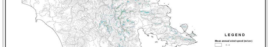
1 Mapping of the theoretical potential for wind energy and small hydropower plants in the region of Peloponnesus Peloponnesus covers an area of some 21,550 km² (8,320 square miles) and constitutes the southernmost part of mainland Greece. While technically it may be considered an island, since the construction of the Corinth Canal in 1893 like other peninsulas that have been separated from their mainland by man-made bodies of waters it is rarely, if ever, referred to as an "island". It has two land connections with the rest of Greece, a natural one at the Isthmus of Corinth, and an artificial one in the shape of the Rio- Antirio bridge (completed in 2004). The Peloponnesus region (Greek: Περιφέρεια Πελοποννήσου), is a region in southern Greece. It borders the West Greece region to the north and Attica to the north-east. The region has an area of about 15,490 km². It covers most of the Peloponnesus peninsula, except for the north-western sub regions of Achaia and Elis, which belong to the Region of West Greece. According to the census of 2005, the population of the Peloponnesus Region was around 650,000. The Peloponnesus region was established in the 1987 administrative reform. With the 2010 Kallikratis plan, its powers and authority were redefined and extended. Along with the West Greece and the Ionian Islands regions, it is supervised by the Decentralized Administration of the Peloponnesus, Western Greece and the Ionian Islands based at Patras. The region is based at Tripoli and is divided into five regional units (pre-kallikratis prefectures), namely Arcadia, Argolis, Corinthia, Laconia and Messenia, which are further subdivided into 26 municipalities. The largest city of the region is Kalamata. A 50% of the total area is characterised as mountainous, 30% as semi-mountainous and 20% as flat area. Also the 25% of the total area is characterised as cultivable and 46% as rangeland. Forests are covering the 10% of the total area, waters the 6% and settlements the 9%. The region is gathering the 6.4% of the total population of Greece and produces the 5% of the Gross Domestic Product (GDP). The per inhabitant GDP is reaching the 51% of the European average index (the index is one of the lowest among European regions). 50% of the total population is living in the plain area, 30% in semi-mountainous areas and 20% in mountainous areas. 1.1 Wind potential In the frame of a national funded project, the theoretical wind potential of Greece has been estimated by making measurements and calculations. CRES installed a network of about 100 measurement points all over Greece and measurements have been recorded for over one year. The results have been combined with simulations based on the digital elevation model of Greece running models for wind potential and the result was the Wind Map of Greece (Peloponnesus included). The last years, even more measurement points (e.g. from the wind masts installed by potential investors,

2 which are obliged to provide their data to CRES) have been integrated to the above mentioned network, so it was made possible to recalculate the theoretical wind potential. Figure 1 presents the wind map of Peloponnesus, i.e. the theoretical wind potential of Peloponnesus, as calculated based on the measurements and simulations. The same figure also includes the contour lines and the prefectures. The resolution of this map is at the level of 150 x 150 m rectangular grid, each cell holding information of mean annual wind velocity. This resolution is the appropriate to assess the basic figures of wind energy potential at a regional level and this give useful output for RES planning. Figure 1: CRES Measurement points in Peloponnesus and overall wind atlas of the region

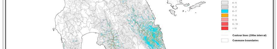

3 Figure 2: Map of the Theoretical Wind Potential of Peloponnesus Figure 3: Map of the Lakonia


4 Figure 4: Wind Map of Arcadia Figure 5: Wind Map of Argolida
. 1.")
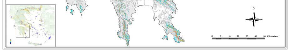
5 Figure 6: Wind Map of Messinia The region of Peloponnese is partitioned into very high wind energy areas located at the east part (Aegean Sea) and medium wind energy areas located in the centre of the region, while low values have been measured to the west part (Ionian Sea). 1.2 Small hydro potential The experimental small hydro potential includes processed results from CRES s measurements of flows for streams with exploitable water flows or measurements that have been performed from other relative offices (Power Public Corporation, Ministry of Agriculture, Ministry of Public Works and Environment). These results correspond to the flow duration curve at selected points of the streams. Based on these results and using the digital elevation model, the flow of the stream at any point could be calculated. These results constitute the theoretical small hydro potential and are the basic input for all the following calculations. Taking into account the above presented information, two areas in the region can be marked. The first area, in the north, comprising wet basins with promising flows for small hydro development and the dry area at the south south west presenting only local sites with flows and heads appropriate for mini hydro projects development. In the following maps the most significant basins are analyzed. The thematic maps present the flow as well as slope values for basins models.

6 Figure 7: Water partings of Peloponnesus; with blue colour are presented the digitized water partings with calculated projects, while with light green the water partings without any projects Part of this hydro potential has already been exploited by the operation of a 70 MW hydroelectric power plant installed at the Ladonas river. Moreover, the majority of the watersheds presented in the above map are not located at the area of the Peloponnesus region (as mentioned in the beginning, the former prefectures of Achaia and Elia, located at the North-west part of the territory, are belonging to the West Greece Region), a detailed analysis of the available potential was carried out for the watershed of river Lousios. The results are presented in the below figure (map).


7 KATO LOUSIOS WATERSHED 1. Map of estimated mean values of water flow along the watershed 2. Map of terrain inclinations along the course of the watershed Figure 8: Lousios down thematic map (water flow and gradient)
Bluetongue emergence in Peloponnisos (Greece) - SCoFCAH, Brussels 3-4 July 2014
 - SCoFCAH, Brussels 3-4 July 2014") HELLENIC REPUBLIC MINISTRY OF RURAL DEVELOPMENT AND FOOD DIRECTORATE GENERAL OF VETERINARY SERVICES ANIMAL HEALTH DIRECTORATE Bluetongue Emergence in Peloponnisos (Greece) (June early July 2014) Dimitrios
HELLENIC REPUBLIC MINISTRY OF RURAL DEVELOPMENT AND FOOD DIRECTORATE GENERAL OF VETERINARY SERVICES ANIMAL HEALTH DIRECTORATE Bluetongue Emergence in Peloponnisos (Greece) (June early July 2014) Dimitrios
WORKING PAPER In the context of the placement in the Observatory of the Egnatia Odos A.E.
 COMPARATIVE ANALYSIS OF POPULATION CHANGES IN THE AREAS CROSSED BY THE THREE BASIC ROAD AXES OF GREECE: THE EGNATIA MOTORWAY, THE PA.TH.E. AND THE IONIAN MOTORWAY WORKING PAPER In the context of the placement
Profile of Attica Attica prefecture of Attica Athens Greece Administration
 Attica ( prefecture of Attica) is an administrative region in Greece, situated at the southernmost point of central Greece. Attica is well-known because of Athens, the capital of Greece. This region covers
Egnatia Odos: An axis for development and co-operation
 Egnatia Odos: An axis for development and co-operation Egnatia Odos is one of the two Trans-European transport axes (the other being PATHE) which cross through our country and, together with the Eleftherios
PRESS RELEASE. Graph 1: Road traffic accidents and casualties, January January Jul-14. Jul-15. Apr-15. Jan-15. Oct-15.
 Jan-11 Apr-11 Jul-11 Oct-11 Jan-12 Apr-12 Jul-12 Oct-12 Jan-13 Apr-13 Jul-13 Oct-13 Jan-14 Apr-14 Jul-14 Oct-14 Jan-15 Apr-15 Jul-15 Oct-15 Jan-16 Apr-16 Jul-16 Oct-16 Jan-17 Apr-17 Jul-17 Oct-17 Jan-18
WP4.4 Cordevole MCA alternatives description
 WP4.4 24/11/2010 version 2.0 Authors Member number and name Sara PAVAN, Matteo Cesca, Alessandro Vianello, Italo Saccardo PP2-ARPAV SHARE - Sustainable Hydropower in Alpine Rivers Ecosystems http://www.sharealpinerivers.eu
34 TH ATHENS AUTHENTIC MARATHON SUNDAY 13 NOVEMBER 2016
 34 TH ATHENS AUTHENTIC MARATHON SUNDAY 13 NOVEMBER 2016 ONE OF THE TOP TEN MARATHONS ACROSS THE GLOBE Why this race -A legendary course (2504 years) -The course that gave its name to the race -A technical
South Aegan Region (Greece)
") South Aegan Region (Greece) South Aegan Region 1. Introduction The South Aegean Region is situated in the south-eastern border of Greece and constitutes at the same time, along with Cyprus, the south-eastern
South Aegan Region (Greece) South Aegan Region 1. Introduction The South Aegean Region is situated in the south-eastern border of Greece and constitutes at the same time, along with Cyprus, the south-eastern
Egnatia Odos Observatory. Egnatia Odos Observatory Monitoring of Egnatia Motorway s s Spatial Impacts
 Egnatia Odos Observatory Egnatia Odos Observatory Monitoring of Egnatia Motorway s s Spatial Impacts 1 Egnatia Odos Observatory 1. The unique Greek observatory of transport and spatial impacts 2. Scope
5th Thematic Seminar "Digitization of libraries and archives"
 5th Thematic Seminar "Digitization of libraries and archives" Policies & implementation tools in Digitization of libraries and archives in the Region of Western Greece PP3: Dept. of Environmental & Natural
C. SYKIANAKI, President, Organization for Planning and Environmental Protection of Athens.
 ! GENERAL PRESENTATION OF THE ATHENS METROPOLITAN REGION (AMR) C. SYKIANAKI, President, Organization for Planning and Environmental Protection of Athens. Athens, July 2006 1 ! The capital city of Athens
ORTHOLOGICAL MANAGEMENT OF HYDROLOGICAL RUNOFF BASINS OF THE PREFECTURE OF DRAMA (CURRENT SITUATION PROTECTIVE ACTIONS PERSPECTIVES)
") ORTHOLOGICAL MANAGEMENT OF HYDROLOGICAL RUNOFF BASINS OF THE PREFECTURE OF DRAMA (CURRENT SITUATION PROTECTIVE ACTIONS PERSPECTIVES) This paper presents the torrential environment of the torrents of the
ORTHOLOGICAL MANAGEMENT OF HYDROLOGICAL RUNOFF BASINS OF THE PREFECTURE OF DRAMA (CURRENT SITUATION PROTECTIVE ACTIONS PERSPECTIVES) This paper presents the torrential environment of the torrents of the
αρχαία Ελλάδα (Ancient Greece)
") αρχαία Ελλάδα (Ancient Greece) The Birthplace of Western Civilization Marshall High School Mr. Cline Western Civilization I: Ancient Foundations Unit Three AA Neolithic Europe Europe s earliest farming
αρχαία Ελλάδα (Ancient Greece) The Birthplace of Western Civilization Marshall High School Mr. Cline Western Civilization I: Ancient Foundations Unit Three AA Neolithic Europe Europe s earliest farming
Geography. Greece s Physical Geography is: Peninsula (water on three sides) The Peloponnesus. Mountainous Terrain (see Map dark green)
 The Peloponnesus. Mountainous Terrain (see Map dark green)") Grapes Greece Geography Greece s Physical Geography is: Peninsula (water on three sides) The Peloponnesus Mountainous Terrain (see Map dark green) Extends into the Aegean Sea Includes over 2,000 Islands
Grapes Greece Geography Greece s Physical Geography is: Peninsula (water on three sides) The Peloponnesus Mountainous Terrain (see Map dark green) Extends into the Aegean Sea Includes over 2,000 Islands
PREMIUM PELOPONNESE WINE TOUR
 PREMIUM PELOPONNESE WINE TOUR Wine Routes in the Land of Myth INTRODUCTION Our tour Greek wine has made huge steps reaching top-class quality levels and gaining more and more supporters worldwide. Faithful
WESTERN PELOPONNESE RAILWAY, PORTS AND ROADS
 WESTERN PELOPONNESE RAILWAY, PORTS AND ROADS Project Key Features Short Description: Project Components: Design and/or Construction, Financing, Operation, Maintenance and Exploitation of rail lines, ports
Hydrological study for the operation of Aposelemis reservoir Extended abstract
 Hydrological study for the operation of Aposelemis Extended abstract Scope and contents of the study The scope of the study was the analytic and systematic approach of the Aposelemis operation, based on
2. SECTOR Energy 1. PROJECT TITLE LOWER VRBAS HYDROPOWER PLANTS
 1. PROJECT TITLE LOWER VRBAS HYDROPOWER PLANTS. SECTOR Energy 3. LOCATION The lower course of the Vrbas, i.e. the stretch from the city of Banja Luka to the mouth of the Vrbas, is planned to accommodate
Note that the steepest 8 direction pour point model slope in direction 64 is: 10.0
 GIS in Water Resources Exercise #3 Solution Part 1. 1.1 Hand Calculations (i) The standard ESRI surface slope function Grid size 10 m Diagonal distance= 14.142 m 47.5 48 47.7 50.6 48.3 dz/dx= -0.125 45.1
HSC Ancient History. Year 2017 Mark Pages 29 Published Feb 12, Ancient History - Comprehensive notes on Sparta. By Gia (99.
 HSC Ancient History Year 2017 Mark 96.00 Pages 29 Published Feb 12, 2018 Ancient History - Comprehensive notes on Sparta By Gia (99.3 ATAR) Powered by TCPDF (www.tcpdf.org) Your notes author, Gia. Gia
IEEJ: June 2010 JICA JFY 2010 Energy Policy (B) NO. J / ID Country Report: Bosnia and Herzegovina March 2010 Prepared by JICA trainee
 NO. J / ID Country Report: Bosnia and Herzegovina March 2010 Prepared by JICA trainee") JICA JFY 2010 Energy Policy (B) NO. J1000606 / ID. 1080149 Country Report: Bosnia and Herzegovina March 2010 Prepared by JICA trainee Mile Srdanovic Bosnia and Herzegovina basic energy related figures
JICA JFY 2010 Energy Policy (B) NO. J1000606 / ID. 1080149 Country Report: Bosnia and Herzegovina March 2010 Prepared by JICA trainee Mile Srdanovic Bosnia and Herzegovina basic energy related figures
Greece: Live your myth
 Greece: Live your myth The official name of Greece is the Hellenic Republic. Athens is the capital of Greece. It is also the most populated city in the country (4 mil) GREECE Location: Southern Europe,
Life in Two City-States: Athens and Sparta
 Life in Two City-States: Athens and Sparta What were the major differences between Athens and Sparta? P R E V I E W Examine the two illustrations of ancient Greek city-states your teacher will show you.
Dr Yiannis Psycharis
 The Political Economy of the Regional Allocation of Public Investment in Greece 1976-2004 Dr Yiannis Psycharis Assistant Professor Department of Planning and Regional Development, University of Thessaly,
Development of the Hellenic Parts of Priority Axes No 22 & 29: A Strategic Approach
 Development of the Hellenic Parts of Priority Axes No 22 & 29: A Strategic Approach Eleni Zacharaki Intermediate Managing Authority for Transport (IMA) / Hellenic Ministry of Transport & Communications
Socio-demographic and Economic Profiles of the Regions in the Republic of Macedonia
 Spatial demography of the Balkans: trends and challenges IV th International Conference of Balkans Demography Session 5: Planning and development challenges -----------------------------------------------------------------------------------------------
2.2. Greece Greece - geography
 2.2. Greece 2.2.1. Greece - geography The Greek Peninsula is located at Europe's southeastern end. It stretches between the 34 th and 41 st parallel and borders Albania (NW), Bulgaria and FYROM (N), Turkey
Stavros Rodokanakis. Regional Development Fund, Region of Central Macedonia, K. Rossidou 11, Thessaloniki, Greece.
 Stavros Rodoanais Regional Development Fund, Region of Central Macedonia, K. Rossidou 11, 540 08 Thessalonii, Greece Tel.: +30-2310-40.93.83 (office) E-mail: srodo2003@yahoo.gr Title: Econometric analysis
COORDINATES OF RURAL DEVELOPMENT WITH LEADER PROGRAM IN COVASNA COUNTY, UNTIL 2014
 LUCRĂRI ŞTIINŢIFICE, SERIA I, VOL.XVII (2) COORDINATES OF RURAL DEVELOPMENT WITH LEADER PROGRAM IN COVASNA COUNTY, UNTIL 2014 KLÁRA - DALMA POLGÁR (DESZKE) 1, LILIANA DUGULEANĂ 2 1 Doctoral student, TRANSILVANIA
Geography of Ancient Greece Summary Sheet for Use in Assessment
 Geography of Ancient Greece Summary Sheet for Use in Assessment 1. At the same time that the Shang dynasty was ruling much of the Huang He River valley and the Egyptian pharaohs were building the New Kingdom
The results of indicators, the reports, and generally the Observatory material are available on the internet at:
 Regional Gross Domestic Product (GDP) 2003 in the Regions of the European Union (EU25) the profile of Regions and Prefectures crossed by the Egnatia motorway The EUROSTAT, the statistical service of the
Today you need: Pencil If you have your notebook-put it in bin. Thank you
 SS Terrific Tuesday 1/23/18 Today you need: Pencil If you have your notebook-put it in bin. Thank you Bell work: Put your name on your paper!!!! Look at the map of Ancient Greece. 1. State two-three observations
Greek Interoperable Tolling Systems (GRITS) Interoperability Travel faster and more conveniently using only one transponder
 Interoperability Travel faster and more conveniently using only one transponder") Greek Interoperable Tolling Systems (GRITS) Interoperability Travel faster and more conveniently using only one transponder The service that makes your journey faster and more convenient, allowing you
Greek Interoperable Tolling Systems (GRITS) Interoperability Travel faster and more conveniently using only one transponder The service that makes your journey faster and more convenient, allowing you
TRIPOLI APRIL Profile of the Municipality of Tripoli
 TRIPOLI APRIL 2014 Profile of the Municipality of Tripoli 2014 Municipality of Tripoli The Municipality of Tripoli is located in the sender of Peloponnese at 650 meters. It is mountainous area, that extents
Good morning! You need: both sheets from yesterday! Write HW in agenda: BRING IN CANS. College day tomorrow: Wear college shirts and hats!
 Good morning! You need: both sheets from yesterday! Write HW in agenda: BRING IN CANS College day tomorrow: Wear college shirts and hats! Ancient Greece BIG IDEA: Greece s geography and closeness to seas
The contribution of Tourism to the Greek economy in 2017
 The contribution of Tourism to the Greek economy in 2017 1 st edition (provisional data) May 2018 Dr. Aris Ikkos, ISHC Research Director Serafim Koutsos Analyst INSETE Republishing is permitted provided
"Transboundary coordination according to the FD Directive in the shared river basins of Greece
 Workshop on Transboundary Issues Budapest March 31st April 1st "Transboundary coordination according to the FD Directive in the shared river basins of Greece Katerina Triantafyllou, ECOS Consulting S.A.
Who goes where? How long do they stay? How much do they spend?
 Who goes where? How long do they stay? How much do they spend? Analysis of inbound tourism by Region and Market Summary Evangelia Lamprou Researcher - Statistician Dr. Aris Ikkos, ISHC Research Director
MANAGING FRESHWATER INFLOWS TO ESTUARIES
 MANAGING FRESHWATER INFLOWS TO ESTUARIES Yuna River Hydrologic Characterization A. Warner Warner, A. (2005). Yuna River Hydrologic Characterization. University Park, Pennsylvania: The Nature Conservancy.
S.Y.K.A.P. GREEK COORDINATION CENTRE AGAINST ILLICIT TRADE
 S.Y.K.A.P. GREEK COORDINATION CENTRE AGAINST ILLICIT TRADE Ministry of Development & Competitiveness General Secretariat of Commerce Composition of SYKAP The Ministry of Development and Competitiveness
Tourism Investment Potential
 Prodexpo October 2016 October 2016 Tourism Investment Potential 1 International Tourist Arrivals & Receipts Greek Tourism continues its positive trend in spite of negative internal and external factors
10 th INSULEUR FORUM Palma de Mallorca, 10-11/6/2010
 10 th INSULEUR FORUM Palma de Mallorca, 10-11/6/2010 Sustainable Development and Insularity - Planning a development policy for insular areas covering a wide typology Agatha Lagi Special Service for Strategy,
Arrival in Athens Athens Mycenae, Nafplion Delphi
 Duration: 7Days / 6Nights Classical Wonders of Greece Day1 Day2 Day3 Day4 Day5 Day6 Day7 Arrival in Athens Athens Mycenae, Nafplion Delphi Kalambaka Athens Departure & Olympia Tour Highlights; -Athens
A day tourism destination HELLENIC MINISTRY OF TOURISM
 A 365 - day tourism destination HELLENIC MINISTRY OF TOURISM GREECE IS A TRUE PARADISE A DESTINATION FOR EVERY TASTE Unique foodie experiences based on the healthy, nutritious and tasty Greek diet Local
Hydraulic Report. Trail 5 Snowmobile Trail Over Mulligan Creek. Prepared By: COLEMAN ENGINEERING COMPANY Karisa V. Falls, P.E.
 Prepared for: Prepared by: Marquette County Road Commission Coleman Engineering Company Marquette, Michigan Iron Mountain, MI December 2011 Hydraulic Report Trail 5 Snowmobile Trail Over Mulligan Creek
Interconnections of Greek islands The Regulatory Approach
 EUROPEAN FORUM ON CLEAN ENERGY FOR ISLANDS, NAXOS, 9-11 JULY 2018 Interconnections of Greek islands The Regulatory Approach Apostolos G. Gkizas Electrical Engineer, MSc, Scientific Expert Head, Electrical
HEALTH SECTOR ECONOMIC INDICATORS REPORT
 HEALTH SECTOR ECONOMIC INDICATORS REPORT For: Mid North Coast Local Health District Report prepared by: April 2013 Table of Contents Introduction 3 Executive Summary 4 Output 5 Value-Added 7 Workforce
Successive steps towards the creation of a Marina at Loutraki - West end of Korinth Canal - Greece
 Successive steps towards the creation of a Marina at Loutraki - West end of Korinth Canal - Greece AJ. Rogan, SJ. Rogan, G. Papageorgiou, C. Solomonidis Rogan Associates, Consulting Engineers - Architects
Clean-Green Energy Solution.The Tilos paradigm.
 Clean-Green Energy Solution.The Tilos paradigm. P. Ktenidis, D. Zafirakis, E. Kondili *, J.K. Kaldellis Research Team Soft Energy Applications and Environmental Protection Laboratory Optimisation of Production
Effect of Geography on Ancient Greece. Chapter 4-1
 Effect of Geography on Ancient Greece Chapter 4-1 Greek Geography Greece is a peninsula that is covered by many mountains. Geography Continued. It is located in the heart of the Mediterranean Sea. The
PROJECTS BREEDING GROUPS MANAGEMENT CONSULTATION FIELD RESEARCH
 PROJECTS BREEDING GROUPS MANAGEMENT CONSULTATION FIELD RESEARCH NATURE OF AMALTHIA PROJECTS BREEDING GROUPS OF OFFICIALLY RECOGNIZED BUT FORGOTTEN BREEDS BREEDING GROUPS OF BURIED SUB POPULATIONS OF OFFICIAL
along a transportation corridor in
 Rockfall hazard and risk assessment along a transportation corridor in the Nera Valley, Central Italy Presentation on the paper authored by F. Guzzetti and P. Reichenbach, 2004 Harikrishna Narasimhan Eidgenössische
Latin America. Physical Geography
 Latin America Physical Geography Regions Latin America can be divided into separate regions based on physical geography or cultural geography. Regions If we look at physical geography Latin America has
Beaches as a resource in Greece
 Beaches as a resource in Greece Estimate of use and socio-economic contribution by Hotels Marinescapes Forum Piraeus, 26/05/15 Updated October 2016 Dr. Aris Ikkos, ISHC Research Director, Institute SETE
Laconia, with the prefecture capital of Sparta,
 Cold-pressed from the food field In the Greek region of Laconia on the Peloponnese, the U.A.C. Lakonia enterprise is filling extra virgin olive oil for a network of Greek smallholders. For this purpose,
Ohrid Lake and Prespa Lake, Sub basin s on Crn Drim river basin International Workshop, Sarajevo, Bosna and Hercegovina May 2009
 Ohrid Lake and Prespa Lake, Sub basin s on Crn Drim river basin International Workshop, Sarajevo, Bosna and Hercegovina 18-20 May 2009 Ms. Darinka Jantinska Ministry of Environment and Physical Planning
Fiji s Tourism Satellite Accounts
 Asia-Pacific Economic Statistics Week Bangkok 2 4 May 2016 Fiji s Tourism Satellite Accounts Mr. Bimlesh Krishna Divisional Manager Economic Statistics Fiji s Tourism Satellite Introduction The Tourism
Innovation Week on Renewable Energy Systems
 Innovation Week on Renewable Energy Systems SOLAR ENERGY PASSIVE SOLAR TECHNOLOGIES WIND ENERGY OCEAN ENERGY CO GENERATION BIOMASS PHOTOVOLTAIC S HYDRO ELECTRICAL ENERGY CLEAN ENVIRONMENT QUALITY IN LIFE
Inspection system for in use pesticide application equiupment in Greece. First three years of application
 Inspection system for in use pesticide application equiupment in Greece. First three years of application G. Bourodimos 1,2, A. T. Balafoutis 3, M. Giamouri 1, S. Fountas 2 1 Hellenic Agricultural Organisation
SECTION 3 GENERAL DESCRIPTION OF THE RIVER BASIN
 SECTION 3 GENERAL DESCRIPTION OF THE RIVER BASIN SECTION 3 GENERAL DESCRIPTION OF THE RIVER BASIN River basin description. A general description of the river basin or subbasin, as appropriate, in which
7. Demand (passenger, air)
") 7. Demand (passenger, air) Overview Target The view is intended to forecast the target pkm in air transport through the S-curves that link the GDP per capita with the share of air transport pkm in the
7. Demand (passenger, air) Overview Target The view is intended to forecast the target pkm in air transport through the S-curves that link the GDP per capita with the share of air transport pkm in the
POLLUTION MONITORING OF SHIP EMISSIONS: AN INTEGRATED APPROACH FOR HARBOURS OF THE ADRIATIC BASIN (POSEIDON)
") POLLUTION MONITORING OF SHIP EMISSIONS: AN INTEGRATED APPROACH FOR HARBOURS OF THE ADRIATIC BASIN (POSEIDON) Implementation between 01/06/2014 and 31/05/2015 http://www.medmaritimeprojects.eu/section/poseidon
POLLUTION MONITORING OF SHIP EMISSIONS: AN INTEGRATED APPROACH FOR HARBOURS OF THE ADRIATIC BASIN (POSEIDON) Implementation between 01/06/2014 and 31/05/2015 http://www.medmaritimeprojects.eu/section/poseidon
LONG-TERM TRENDS AND RECENT UPTURNS IN REGIONAL MORTALITY VARIATIONS IN GREECE
 European Journal of Geography Volume 9, Number 1: 6-22, March 2018 Association of European Geographers LONG-TERM TRENDS AND RECENT UPTURNS IN REGIONAL MORTALITY VARIATIONS IN GREECE Vasilis S. GAVALAS
possession rate of vehicles and basic developmental indicators in the impact zone of Egnatia motorway, Greece THESSALONIKI, Oct.
 Αύγουστος 27 possessiion rate off vehiiclles and basiic devellopmentall iindiicators iin the iimpact zone off Egnatiia motorway,, Greece THESSALONIKI, Oct. 27 The present report gives an overview of the
Land Figures & Spatial Data Infrastructure in KOSOVO
 Land Figures & Spatial Data Infrastructure in KOSOVO Idriz SHALA idriz.shala@gmail.com GIS -expert Afrim SHARKU afrim.sharku@gmail.com Land Management - Expert Kick-off meeting of the Regional Expert Advisory
TRAVEL ABROAD WITH FLORIDA COLLEGE
 A T H E N S C O R I N T H O L Y M P I A D E L P H I M Y C E N A E P H I L I P P I T H E S S A L O N I K I TRAVEL ABROAD WITH FLORIDA COLLEGE FOR MORE INFORMATION, PICK UP A BROCHURE AT THE FLORIDA COLLEGE
Management of Contaminated Sites in Greece
 EIONET Workshop on Soil 10-12 /12/2012 Management of Contaminated Sites in Greece Dr Sid. Theocharopoulos Director Soil Science Institute of Athens Helenic Agricultural Organization DEMETER (ex NAGREF)
RESULTS FACT SHEET INDICATOR - SET13: COMPOSITION OF GROSS VALUE ADDED (GVA) PER SECTOR
 PER SECTOR") RESULTS FACT SHEET INDICATOR - SET13: COMPOSITION OF GROSS VALUE ADDED (GVA) PER SECTOR DEFINITION- OBJECTIVE This indicator records the composition of the Gross Value Added (GVA) per Prefecture/Region
RESULTS FACT SHEET INDICATOR - SET13: COMPOSITION OF GROSS VALUE ADDED (GVA) PER SECTOR DEFINITION- OBJECTIVE This indicator records the composition of the Gross Value Added (GVA) per Prefecture/Region
Lesson 1
 Lesson 1 Objectives Evaluate how geography affected people of the Aegean Cultures. Study the effects of trade on he growth of the Minoan customs and ideas to their way of life. Observe how the Mycenaeans
Ancient Greece GREECE UNIT 5 GEOGRAPHY CHALLENGE. 1 Unit 5 Geography Challenge miles. Lambert Azimuthal Equal-Area Projection
 W N S E UNIT 5 GEOGRAPHY CHALLENGE Ancient Greece 0 250 500 miles 0 250 500 kilometers Lambert Azimuthal Equal-Area Projection GREECE 1 Unit 5 Geography Challenge UNIT 5 GEOGRAPHY CHALLENGE Geography Skills
Peloponnese Multi-Activity Holidays
 Peloponnese Multi-Activity Holidays COUNTRY: Greece LOCATION: Peloponnese, Nafplio Tripoli- Kalamata DEPARTURES: 2018, every Saturday from April-October DURATION: 8 days PRICE: 860p.p. excluding flights,
Regional Authority of Central Macedonia
 Greece Regional Authority of Central Macedonia Urban area of Thessaloniki What we HAVE -Municipality of Thessaloniki (city centre) of 325.182 people -An Urban Area of 790.824 inhabitants and an area of
The Isonzo/Soca river basin
 Geneva September 8 th 2014 The Isonzo/Soca river basin Status and perspective on the possible Alpine river basin to be assessed The Alpine Convention Water management, risk management and adaptation to
THE IMPLEMENTATION OF EWFD/WFD IN THE REGION OF VOJVODINA WITHIN JOINT SLOVAK-SERBIA SERBIA PROJECTS
 Towards Integrated River Basin Management The 55 th Anniversary of the Founding of the Water Research Institute THE IMPLEMENTATION OF EWFD/WFD IN THE REGION OF VOJVODINA WITHIN JOINT SLOVAK-SERBIA SERBIA
3-day trip with rafting at Lousios, and not only!
 3-day trip with rafting at Lousios, and not only! Plan Days 3 Excursion in nature and the villages of Arcadia and the archaeological sites of Korinthia! A weekend full of beautiful pictures! By: Christina
GC 225 Lecture Exam #2
 GC 225 Lecture Exam #2 Direction- path along which something is moving. 3 Types; - COMPASS DIRECTIONAL NAME (32 in total) - BEARING (four 0 o - 90 o ) - AZIMUTHS (0 o - 360 o ) Compass (32 named points)
Natural and man-made flooding hazards at the torrents in the town of Thessaloniki
 Risk Analysis VII PI-373 Natural and man-made flooding hazards at the torrents in the town of Thessaloniki S. Stefanidis, F. Tziaftani & C. Chatzicristaki Institute of Mountainous Water Management and
Transboundary Water Management in Republic of Macedonia
 12th International Conference EUROPE-INBO 2014 12-15 November 2014, Bucharest, Romania. Transboundary Water Management in Republic of Macedonia Ylber Mirta Head of Department for Waters ymirta@gmail.com
The Potential of Renewable Energy Sources in Bosnia and Herzegovina
 The Potential of Renewable Energy Sources in Bosnia and Herzegovina Petar M.Gvero, Ph.D.,M.Sc. Assistant Professor Climate Change in South-Eastern European Countries: Causes, Impacts, Solutions Graz, Austria
Electronic Terrain and Obstacle Data
 International Civil Aviation Organization Electronic Terrain and Obstacle Data David Lewtas Chief, Aeronautical Information Unit (MET/AIM) 24 November 2010 ICAO CAR AIM Seminar Kingston, Jamaica 22-24
1. Dissemination Activities (September January 2018)
") 3 nd Newsletter 1. Dissemination Activities (September 2017- January 2018) Den Cupid in Greece From September to December 2017 a number of dissemination and multiplier events took place making the DEN
3 nd Newsletter 1. Dissemination Activities (September 2017- January 2018) Den Cupid in Greece From September to December 2017 a number of dissemination and multiplier events took place making the DEN
Get a higher Return On Investment with Wärtsilä
 Get a higher Return On Investment with Wärtsilä Wärtsilä reciprocating engine technology outperforms gas turbines in the ISO-NE market Joseph Ferrari www.industrialinfo.com Wärtsilä Wärtsilä Founded in
Plot of sq.m. at the beach Orkos of Kea (Tzia) in Cyclades GENERAL INFORMATION ON THE PLOT
 in Cyclades GENERAL INFORMATION ON THE PLOT") Plot of 165.000 sq.m. at the beach Orkos of Kea (Tzia) in Cyclades GENERAL INFORMATION ON THE PLOT Kea 2009 Plot of 165.000 sq.m., ideal for investment in Cyclades Cyclades and Crete are "champions in
Plot of 165.000 sq.m. at the beach Orkos of Kea (Tzia) in Cyclades GENERAL INFORMATION ON THE PLOT Kea 2009 Plot of 165.000 sq.m., ideal for investment in Cyclades Cyclades and Crete are "champions in
Spartan Society Complete Notes (12th IN STATE 2016)
") HSC Ancient History Year 2016 Mark 98.00 Pages 42 Published Jan 29, 2017 Spartan Society Complete Notes (12th IN STATE 2016) By Vrinda (99.65 ATAR) Powered by TCPDF (www.tcpdf.org) Your notes author, Vrinda.
HSC Ancient History Year 2016 Mark 98.00 Pages 42 Published Jan 29, 2017 Spartan Society Complete Notes (12th IN STATE 2016) By Vrinda (99.65 ATAR) Powered by TCPDF (www.tcpdf.org) Your notes author, Vrinda.
Corporate Presentation
 Corporate Presentation April 2016 Intracom Holdings / The Shareholder One of the leading construction groups in Greece A major European IT solutions and services group Greece's largest manufacturer of
Corporate Presentation
 Corporate Presentation July 2016 Intracom Holdings / The Shareholder One of the leading construction groups in Greece A major European IT solutions and services group Greece's largest manufacturer of defense
How to develop resilient infrastructure (Global SDG9)
") How to develop resilient infrastructure (Global SDG9) 16-17 November 2017, Ljubljana, Slovenia Development of resilient rail infrastructure, practices in the Republic of Macedonia Darko Miceski Viktorija
How to develop resilient infrastructure (Global SDG9) 16-17 November 2017, Ljubljana, Slovenia Development of resilient rail infrastructure, practices in the Republic of Macedonia Darko Miceski Viktorija
Ancient Greece. Teachers Curriculum Institute Geography and the Settlement of Greece 1
 G e o g r a p h y C h a l l e n g e Ancient Greece G R E E C E N W E S 0 250 500 miles 0 250 500 kilometers Lambert Azimuthal Equal-Area Projection Teachers Curriculum Institute Geography and the Settlement
2nd International Rhodes Tourism Forum November 2006
 2nd International Rhodes Tourism Forum 10 11 November 2006 Eleni Desylla Tourism Sector Manager HELLENIC CENTER FOR INVESTMENT 1 THE GREEK INVESTMENT INSTITUTIONAL FRAMEWORK AND THE EXISTING AND FUTURE
Invest in Albania. Riyadh, November 29, Page 1
 Invest in Albania Riyadh, November 29, 2016 Page 1 Country Profile Albania Located in the center of Southeastern Europe at major crossroads. Neighboring: Surface: Population: Coastline: Climate: Int. Airport:
Hypsometric demography of Kosovo: the distribution of Kosovo population by altitude
 DOI 10.1186/s40410-016-0047-8 RESEARCH ARTICLE Open Access Hypsometric demography of Kosovo: the distribution of Kosovo population by altitude Rizah Murseli * and Hazer Dana The original version of this
Chapter 4. Daily Focus Skills
 Chapter 4 Daily Focus Skills Chapter 4 On a historical map of the ancient Mediterranean area, locate Greece and trace the boundaries of its influence to 300 BC/BCE. Explain how the geographical location
3rd GRADE MINIMUM CONTENTS UDI 1: LANDSCAPES (5)
") 3rd GRADE MINIMUM CONTENTS UDI 1: LANDSCAPES (5) DIFFERENT LANDSCAPES A landscape is all the things that we see in a place. There are different types of landscapes. Mountain landscapes have mountains and
3rd GRADE MINIMUM CONTENTS UDI 1: LANDSCAPES (5) DIFFERENT LANDSCAPES A landscape is all the things that we see in a place. There are different types of landscapes. Mountain landscapes have mountains and
THE MUNICIPALITY of PROZOR-RAMA
 Bosnia and Herzegovina Federation of Bosnia and Herzegovina Herzegovina-Neretva Canton THE MUNICIPALITY of PROZOR-RAMA I T S D E V E L O P M E N T S T R A T E G Y B U S I N E S S ZONES S U B S I D Y S
Airline network optimization. Lufthansa Consulting s approach
 Airline network optimization Lufthansa Consulting s approach A thorough market potential analysis lays the basis for Lufthansa Consulting s network optimization approach The understanding of the relevant
CORALFISH 2009 Cruise Report: CF0609. Eastern Ionian, Cephalonia and Zakynthos
 CORALFISH 2009 Cruise Report: CF0609 15-25 th June 2009 Eastern Ionian, Cephalonia and Zakynthos Dr. Chris Smith & Shipboard Scientific Crew Hellenic Centre for Marine Research CoralFISH: EU Project 213144,
USE OF 3D GIS IN ANALYSIS OF AIRSPACE OBSTRUCTIONS
 USE OF 3D GIS IN ANALYSIS OF AIRSPACE OBSTRUCTIONS A project by by Samuka D. W. F19/1461/2010 Supervisor; Dr D. N. Siriba 1 Background and Problem Statement The Airports in Kenya are the main link between
Recapturing the Spatial Dynamics of the Venetian Occupation Period
 Recapturing the Spatial Dynamics of the Venetian Occupation Period of Merabello in Eastern Crete through a GIS Approach MARIANNA KATIFORI'-^ ' University of Crete, Dept. of History & Archaeology and Dept.
Hungry 4 History Trivia VA Studies 2010 and beyond
 Hungry 4 History Trivia VA Studies 2010 and beyond Level 1 1 What may be described using terms that show connections between two places such as: next to, near, or bordering? 2 3 What two large bodies of
Topographic Maps. Background Sheet
 Topographic Maps History: Background heet The Articles of Confederation (1777) was ratified when western lands were yielded to the Federal Government. This yielding of land gave the Federal Government