May's Island Historic District. Cedar Rapids. Multiple, see continuation sheet. Linn County Courthouse. 3rd Avenue Bridge. Iowa Linn.
|
|
|
- Erik Barber
- 6 years ago
- Views:
Transcription
1 May's Island Historic District Cedar Rapids Iowa Linn Multiple, see continuation sheet Linn County Courthouse 3rd Avenue Bridge Cedar Rapids Iowa

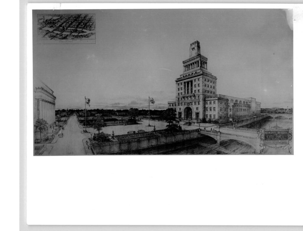
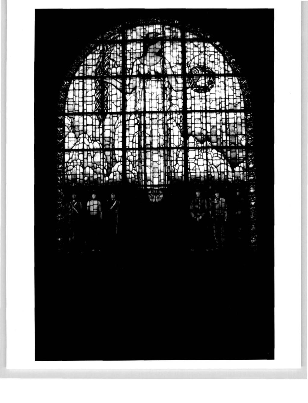
2 Cedar Rapids is located on the Cedar River, which bisects the city into two roughly equal portions. At the point where the river flows through the central business district is a narrow island, approximately 1250 feet long. This natural feature (artifically lengthened at the upper end) is the basis for an arrangement of government buildings (city, county, federal), three of which are on the island itself, and the fourth on the northeast bank. Three concrete arched deck bridges cross the upper two-thirds of the island and serve, like mooring lines, to tie the battleshipshaped island to the riverbanks. The buildings (except, perhaps for the county jail) are executed in monumental scale and design, replete with classical features in a somewhat late ( ) expression of "city beautiful" planning and architecture. The principal feature is the Manorial Building (city hall) located at the extreme upper end of May's Island. The Linn County Courthouse, on the lower third of the island, faces the Memorial Building across a now rather bleak, once landscaped sward which now covers an underground parking garage. The county jail, small, plain, functional, is located behind the courthouse, toward the lower tip of May's Island. On the right bank, directly across from the Memorial Building is the Federal Building, always considered part of the complex, but whose orientation is away from the island. (by Hunter and Hatton, Cedar Rapids) The Memorial Building fills the whole upper end of May's Island. Its interior combines oommunity center facilities and administrative space (including a largecoliseum), used by veterans' groups, the Chamber of Commerce, and others. At the south end of this section is a seven-story office tower, whose stepped arrangement houses city government offices. The verticality of Moderne commercial design suggesting newer currents of architectural expression contrasts with the use of classical forms in decoration which were a holdover from the earlier Beaux: Arts. Three-quarters of the Memorial Building's length is occupied by the auditorium and attendant facilities. This section is four stories high, with parapet roof, narrow cornice and balustrade around the roof at the extreme north end. An arcade of high round-arched windows marks the auditorium proper. The extreme length is broken by short, 2½-story wings. The office tower, with its flanking, 3-story wings, is ponderously symbolic both in form and decoration. The principal ground-level feature is the two-story stained-glass window by Grant Wood, which on the exterior forms a "triumphal arch" below a terracotta spread eagle with shield and memorial panel. Centered in the second stage are two recessed Doric columns. Crowning the assemblage is a cenotaph on which is set a replica of the Tomb of the Unknown Soldier. i Facing the Memorial Building, is the Linn County Courthouse. The first of the present May's Island structures, it is Beaux Arts in style, executed in limestone on a granite foundation, from designes by Urbana architect Joseph Royer. It consists of a main block with two short wings, all parapetted, the whole presenting a massive, earthbound appearance. Appropriate classical elements are found in the full entablature and in the protruding, 9-bay entrance porch. The latter features freestanding, fluted Ionic columns which support the entablature and parapet. The two floors of windows are separated by decorative stone panels. Additional detail is found in the stone balustrade around the terrace, and the small balconies on the first floor windows flanking the entrance pavilion. The sides and rear of the courthouse are much simpler in execution, although the cornice is carried round to the rear corners. No major exterior alterations have been made to the building, although an esplanade see continuation sheet
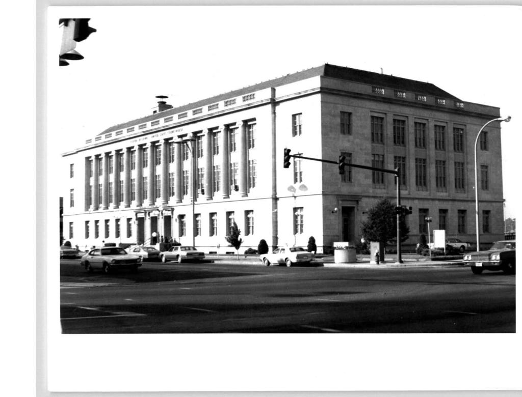
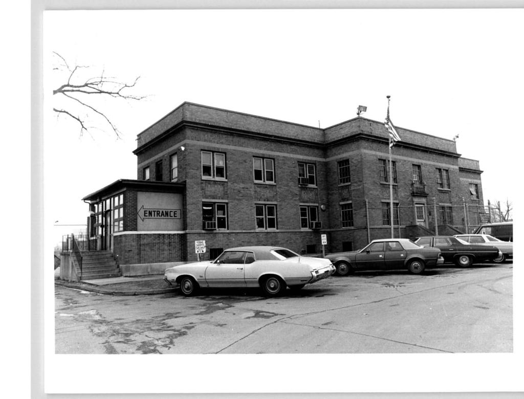
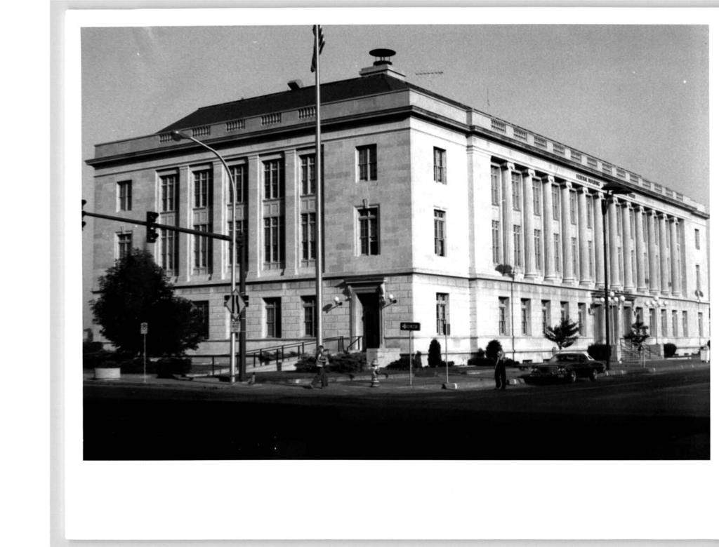
3 May's Island Historic District below the entrance staircase has been reworked. The interior features a central, three-story rotunda, with rooms opening onto corridors which ring the open area. Much of this area has been occupied by office activities. The county jail, also by Joseph Royer, is a utilitarian structure which lacks architectural significance, but is important as it serves as a counterweight to the massive Memorial Building on the opposite end of the island. The jail is two stories high, with a T-shaped plan and protruding central pavilion on the main elevation. The raised basement is marked off with a stone stringcourse. Bricks used in construction are laid in stretcher bond, and headers are used in panels between the stories and as a frieze below the narrow cornice. Plain windows are found singly and in pairs. A modicum of decoration is offered in the balustraded cornice and frieze panel above the front entrance. Public access is gained via a small vestibule on the east side. (by J.A. Wetmore, Treasury Dept.) The Federal Building is located on the east bank of the river, directly across from the Memorial Building. In function and architecture, it is compatible with the island complex; however, its originally-planned orientation toward the river was reversed in execution, and it faces the CBD, rather than the Island, which gives this structure an air of being set apart psychologically as well as physically. The Federal Building is E-shaped in plan, with a parapetted hipped roof. It is three stories high, constructed of Indiana limestone, in a three-stage composition typical of Beaux Arts. Windows are recessed, with narrow 4/4 sash grouped in pairs or triplets, with single lights above stone millions. Entrances are at northeast and southeast corners, and centered in the first story of the east (front) elevation. All have narrow cornices supported by scroll brackets. Most decorative detail is concentrated in the two-story second stage. The front features a 13-bay arcade of partially engaged, fluted Ionic columns and decorative panels below the thirdstory windows. On north and south, pilasters separate the five window bays which are centrally-grouped in the facades. The wide frieze is slightly decorated with small, square medallions. The third stage consists of the parapet, with groupings of balusters inset at intervals above the cornice. The Memorial Building, Federal Building and County Courthouse are all in good condition. The jail is less so, and the county is considering its replacement. The bridges, originally built in the early decades of this century, were extensively remodelled in the 1960's. The river walls, on the island and the riverbanks, are in rather poor condition. A feasibility study is underway to consider the possibility of replacing the Memorial coliseum space with offices for the city, while at the same time retaining the external characteristics of the building as they presently are.

4 Joseph Royer, Urbana; Hunter and Hatton, Cedar Rapids; James A. Wetmore, U.S. Treasury Dept. May's Island Historic District is principally significant as an example of creative urban planning. A natural feature -- the island in the river which bisects the CBD was developed to create a link, both physical and psychological, between the two parts of the city of Cedar Rapids. On the island are concentrated facilities of local and county government, which are complemented, in style and function, but the Federal building on the east bank. This fortuitous concentration of government activity contributes to a local sense of civic and commercial unity seldom found in cities bisected by rivers: another Iowa city, Waterloo, is divided by the same river, and for much of its history exhibited a fair amount of disharmony and competition between the communities on each side of the waterway. W m The arrangement of buildings is a consequence of the island's shape: long and narrow. Most prominent is the Memorial Building, which anchors the north end. It is balanced by the Linn County Courthouse and jail toward the south end of the island; the jail, though architecturally unremarkable, is a crucial physical element in the balanced configuration. The fact that the fronts of the city and county buildings face one another gives the complex an extra insular quality: a 1908 plan originally proposed that buildings on the island be double-fronted, oriented not toward, one another but to the river bank. Architecturally, the Federal Building and county courthouse are straightforward examples of Beaux Arts civic design. The Memorial Building, on, the other hand, combines elements of this style with the verticality of the Moderne, the whole topped with classical funerary features which advertise its purpose as a war memorial. Beyond this obvious visual symbolism, this building represents a joint effort on the part of veterans' groups, local government, and commercial and business interests, to combine in this structure a variety of functions: war memorial, city hall, and convention center. Although the present configuration of buildings on May's Island was not realized until 1927, the river and its island were from the turn of the cnetury the focus of civic planning. About 1900, a local attorney, T.H. Simmons, proposed the connection of May's Island to the east bank with fill, and the erection of a municipal building on the newly-created neck of land. The integrity of the island, however, was apparently of local concern: the next suggestion, part of an urban planning study by C.M. Robinson in 1908, was that the city purchase the island and erect civic facilities thereon. The city acquired the island that same year, and began development by the building of balustraded retaining walls on both sides of the island from 2nd to 4th Avenues. A brick warehouse on the island was converted into a city hall. Concrete bridges were constructed across the river at 2nd Ave. (1906), 3rd Ave. (1911) and 1st Ave. (1914). and two more blocks of river wall built along the west bank. SEE CONTINUATION SHEET
5 May's Island Historic District, Cedar Rapids, Linn County, Iowa Political events after WWI offered a major opportunity to further develop May's Island. In 1920, after nearly 65 years of controversey, the county seat was by public vote removed from its original location at Marion to Cedar Rapids. The previous year, Cedar Rapids deeded a portion of the island to the county, clearly in anticipation of (or to further ensure) a favorable vote. The Linn County Courthouse and jail, completed by 1925, became the first elements in the development of the "government island". The Memorial Building, completed in 1927, combined a variety of interests so wide as to virtually guarantee its existence. As a war memorial, it fulfilled the desire of local veterans' groups for some symbol of patriotism and remembrance. City government, too, realized their plan for substantial office space of a quality higher than that of their former-warehouse facility. Business and community leaders lent support to both these aims, but were lured principally by the idea of a coliseum, which would help Cedar Rapids compete with Des Moines in the lucrative convention business. The proposed Memorial Building received wide local press coverage during 1925 and Interestingly, the first design by architects Harry Hunter and Norman Hatton was not carried through. This initial proposal cabled for a traditional civic building in the Beaux Arts tradition, similar to the county courthouse. However, in comparison with the building ultimately erected, this early attempt would have been termed "insufficiently symbolic", lacking the features with which to "perpetuate...the spirit of those men who went and did not come back" (Cedar Rapids Gazette, 18 May 1925). The final plans filled this lack: Grant Wood's memorial window, which from the outside suggests a triumphal arch; and the cenotaph crowned with the replica of the Tomb of the Unknown Soldier, make the symbolic purpose of the structure unmistakeable. The completion, in 1933, of the Federal Building (originally a post office), rounded out the development of the May's Island Historic District as a government complex. The only further development was the addition of an underground parking garage, which, although not visible, rendered the central green space unsuitable for future landscaping efforts. r

6 Murray, Janette S., and Frederick G. Murray, The Story of Cedar Rapids. New York: Stratford House, Federal Writers' Project. Guide to Cedar Rapids and Northeast Iowa. Cedar Rapids: Laurance Press, Rall, J.F. "The City Plan of Cedar Rapids, Iowa," American Landscape Architect, February, 1930, pp SEE CONTINUATION SHEET approximately 35 acres See Revision 8.V.78 (attached) District is bounded on east and west by the river walls along the east and west banks of the Cedar River, and on north and south by lines drawn approximately 40 feet north and south (respectively) of the upper and lower ends of May's Island. Also included is the contiguous property bounded on the north by 1st Avenue, on the east by 1st Street, on the south by 2nd Avenue, and on the west by the Cedar River, all in Cedar Rapids, Iowa. Edward Sauter Brown Healey Bock M.H. Bowers Division of Historic Preservation rd Ave. SE 26 East Market Street Cedar Rapids Iowa City Director, Division of Historic Preservation
7 May's Island Historic District, Cedar Rapids, Linn County, Iowa Baughman, C.W. "Notes on Civic Center of Cedar Rapids," American Landscape Architect, February, 1930, p. 27. Robinson, Charles Mulford."Civic Improvement and Beautification, City of Cedar Rapids, Iowa". Cedar Rapids: The Torch Press, Memorial Building Campaign Committee. "Questions and Answers about the combined Memorial Coliesum and City Hall", pamphlet, "A City Plan for Cedar Rapids", published by City Plan Commission, Cedar Rapids, Cedar Rapids Gazette, May 7, 9, 13, 15, 16, 18, 19, 21, 25, 26, 27, 28, 29, Fowler, Francis E. " A Short History of the Linn County Courthouse, ", ms. Item 4: Owner of Property City of Cedar Rapids, City Hall, Cedar Rapids, Iowa Linn County, Courthouse, Cedar Rapids, Iowa General Services Administration (US): local: 101 1st St. SE, Cedar Rapids, Iowa Regional: Region 6, 1500 East Bannister Road, Kansas City, MO 64131
8 May's Island Historic District, Cedar Rapids, Linn County, Iowa Boundary Revision: The area included in this nomination comprises a discontinuous district made up of May's Island, its river walls, and structures located thereon (Memorial Building, Linn County Courthouse, Linn County Jail); and a portion of land on the east bank of the Cedar River (on which is located the Federal Building), bounded on the north by 1st Avenue, on the east by 1st Street, on the south by 2nd Avenue, and on the west by the Cedar River. Due to the fact that the 1st, 2nd, and 3rd Avenue bridges, as well as the river walls on the east and west banks of the Cedar River, have been extensively altered since their original construction, these elements are not considered significant in terms of this nomination. Acreage: May's Island, approximately 9½ acres Federal Building lot, approximatly 2 acres Revised UTM: May's Island: Federal Building: A 15/ A 15/ B 15/ B 15/ C 15/ C 15/ D 15/ D 15/
9 Cedar Rapids May's Island

10 May's Island Historic District Cedar Rapids, Linn Co., Iowa May's Island: A 15/ B 15/ C 15/ D 15/ Federal Building: A 15/ B 15/ C 15/ D 15/
11
12
13
14
15
16
17
301 7½ Street SW
 301 7½ Street SW 104-0213-0072 Primary Resource Information: Single Dwelling, Stories 2.00, Style: Other, ca 1890 July 2006: This late-19th-century, 3-bay, 2-story, hip-roofed frame I-house features projecting
808 Cherry Avenue
 808 Cherry Avenue 104-0213-0059 Primary Resource Information: Single Dwelling, Stories 2.00, Style: Other, ca 1900 July 2006: This 2-story, 3-bay frame I-house features a central-front gable, a brick pier
Subject(s): Century II (aka Auditorium, Cultural Center, Civic Center, Civic Cultural Center)
: Century II (aka Auditorium, Cultural Center, Civic Center, Civic Cultural Center)") Tihen Notes Subject Search, p. 1 Dr. Edward N. Tihen (1924-1991) was an avid reader and researcher of Wichita newspapers. His notes from Wichita newspapers -- the Tihen Notes, as we call them -- provide
Tihen Notes Subject Search, p. 1 Dr. Edward N. Tihen (1924-1991) was an avid reader and researcher of Wichita newspapers. His notes from Wichita newspapers -- the Tihen Notes, as we call them -- provide
500 Preston Place. Garages PRESENT USE: Garages PRESENT OWNER: Preston Court Limited Partnership ADDRESS:
 PRESTON PLACE 500 Preston Place STREET 500 Preston Place MAP & PARCEL: 5-116 Garages Garages PRESENT OWNER: Preston Court Limited Partnership 413 7 th Street NE Charlottesville, Va. 22902 DATE/ PERIOD:
DESIGNATION REPORT KENNEDY-BAKER-WALKER-SHERRILL HOUSE (1849) 9320 KINGSTON PIKE (CLT ) KNOXVILLE, TENNESSEE July 12, 2007
 9320 KINGSTON PIKE (CLT ) KNOXVILLE, TENNESSEE July 12, 2007") DESIGNATION REPORT KENNEDY-BAKER-WALKER-SHERRILL HOUSE (1849) 9320 KINGSTON PIKE (CLT 132-027) KNOXVILLE, TENNESSEE July 12, 2007 Description The Kennedy-Baker-Walker-Sherrill House is located on the south
DESIGNATION REPORT KENNEDY-BAKER-WALKER-SHERRILL HOUSE (1849) 9320 KINGSTON PIKE (CLT 132-027) KNOXVILLE, TENNESSEE July 12, 2007 Description The Kennedy-Baker-Walker-Sherrill House is located on the south
National Register of Historic Places Inventory Nomination Form
 NPS Form 10-900-a Exp. 10-31-84 Continuation sheet 4 5 item number 7 Page 45 NAME: Knight Estate LOCATION: 486 East Avenue,,--v..u^-^ OWNER: State of Rhode Island Department of Education Board of Regents
Our Lady and St Edward. Gordon Road, St Ann s, Nottingham NG3. National Grid Reference SK Statement of Importance
 Our Lady and St Edward Gordon Road, St Ann s, Nottingham NG3 National Grid Reference SK 586 409 Statement of Importance The rather unprepossessing exterior of the church contrasts with the reposeful and
THE BARNACLE 3485 MAIN HIGHWAY
 THE BARNACLE 3485 MAIN HIGHWAY Designation Report City of Miami REPORT OF THE CITY OF MIAMI PLANNING AND ZONING DEPARTMENT TO THE HISTORIC AND ENVIRONMENTAL PRESERVATION BOARD ON THE POTENTIAL DESIGNATION
September 13, Presented by: Jeremy Parsons PLANNING & ECONOMIC DEVELOPMENT DEPARTMENT
 Recommendation to Designate Property Located at 828 Sanatorium Road, Hamilton (Mountain Sanatorium Brow Campus) Under Part IV of the Ontario Heritage Act () September 13, 2018 Presented by: Jeremy Parsons
THE FORMER GIRLS' HIGH SCHOOL IN MOSTAR A D A P T I V E R E - U S E P R O P O S A L F O R
 THE FORMER GIRLS' HIGH SCHOOL IN MOSTAR A D A P T I V E R E - U S E P R O P O S A L F O R A M A J O R P U B L I C B U I L D I N G I N T H E O L D C I T Y 1. INTRODUCTION Dr. Stefano Bianca, Director, Historic
 Page 1 Original Update HISTORICAL STRUCTURE FORM FLORIDA MASTER SITE FILE Consult Guide To Historical Structure Forms for detailed instructions Site # 8OR9844 Recorder # 26 Recorder Date 2/20/08 Site Name
PROJECT: Rehabilitate Historic Bathhouses for Adaptive Use
 LOCATION: Hot Springs National Park, Hot Springs Arkansas SIZE: Approximately 105,000 sf among six buildings DATE: 2003-present ROLE: Project Manager for Historic Structure Reports, pre-design through
National Register of Historic Places Continuation Sheet
 Section number N/A Page 1 Proposed Amendment to Wichita, Sedgwick County, Kansas The owner of the building at 141 S. Rock Island Avenue requests amendment to the boundaries of the East Douglas Historic
Change dormers and main entry on the river side of the house. Site: 43 Riverbank Road, Block 10 Lot 3
 City of Burlington Historic Preservation Commission Meeting Minutes: December 2, 2015 The City of Burlington Historic Preservation Commission held its regular monthly meeting on Wednesday, December 2,
STATE OF IOWA. Historical and Architectural Survey for 2008 Flood Projects in Vinton, Benton County
 STATE OF IOWA CHESTER J. CULVER GOVERNOR PATTY JUDGE LT. GOVERNOR DEPARTMENT OF PUBLIC DEFENSE IOWA HOMELAND SECURITY AND EMERGENCY MANAGEMENT DIVISION DAVID L. MILLER, ADMINISTRATOR Historical and Architectural
Commonwealth of Massachusetts Massachusetts Historical Commission 220 Morrissey Boulevard, Boston, Massachusetts
 Inventory No: Historic Name: Common Name: Address: HRV.165 Blood, Joseph House Farnsworth, Jonathan - Beaman, Jonathan House 74 Poor Farm Rd City/Town: Village/Neighborhood: Local No: 9-17 Year Constructed:
SURVEY OF PUBLIC HOUSES WESTON TURVILLE
 BUCKINGHAMSHIRE ARCHAEOLOGICAL SOCIETY HISTORIC BUILDINGS GROUP SURVEY OF PUBLIC HOUSES IN THE PARISH OF WESTON TURVILLE BUCKINGHAMSHIRE A record of extant buildings that are currently or were formerly
New Orleans Historic District Landmarks Commission Nomination Report 210 State Street, former NOAH Campus July 17, 2014
 New Orleans Historic District Landmarks Commission Nomination Report 210 State Street, former NOAH Campus July 17, 2014 Meeting Date: July 17, 2014 Property Address: Owner: 210 State Street Children s
Friends Meeting House, Leicester. 16 Queens Road, Leicester, LE2 1WP. National Grid Reference: SK Statement of Significance
 Friends Meeting House, Leicester 16 Queens Road, Leicester, LE2 1WP National Grid Reference: SK 59852 02815 Statement of Significance A meeting house purpose-built on a new site in 1955 and slightly enlarged
FLAGLER WORKER S HOUSE FORT DALLAS PARK S.E. 4 STREET
 FLAGLER WORKER S HOUSE FORT DALLAS PARK 60-64 S.E. 4 STREET Designation Report City of Miami REPORT OF THE CITY OF MIAMI PLANNING DEPARTMENT TO THE HERITAGE CONSERVATION BOARD ON THE POTENTIAL DESIGNATION
CITY OF MURFREESBORO HISTORIC ZONING COMMISSION. Regular Meeting June 19, :30 PM, Council Chambers, City Hall
 CITY OF MURFREESBORO HISTORIC ZONING COMMISSION Regular Meeting June 19, 2018 3:30 PM, Council Chambers, City Hall I. Call to Order and determination of a quorum II. Approve Minutes of the Regular Meeting
56 QUEEN STREET. Neo-Classic. architectural description. Architect Merwin Austin, Rochester, N.Y. Port Hope Town Hall circa
 Architect Merwin Austin, Rochester, N.Y. Date Designated: June 27, 1994 to By-Law No. 21/94, SCHEDULE B-1 Lot Description: PT 51 (PART OF ORIGINAL TOWN LOTS S 48, 49, 50 architectural description S et
1 Gildersleeve Wood (DHR # )
") GILDERSLEEVE WOOD 1 Gildersleeve Wood (DHR # 104-5092-0012) STREET ADDRESS: 1 Gildersleeve Wood MAP & PARCEL: 11-20 PRESENT ZONING: R-1U ORIGINAL OWNER: Lindsay Family ORIGINAL USE: PRESENT USE: PRESENT
GILDERSLEEVE WOOD 1 Gildersleeve Wood (DHR # 104-5092-0012) STREET ADDRESS: 1 Gildersleeve Wood MAP & PARCEL: 11-20 PRESENT ZONING: R-1U ORIGINAL OWNER: Lindsay Family ORIGINAL USE: PRESENT USE: PRESENT
United States Department of the Interior National Park Service. Boundary Expansion Listed in National Register January 11, 2017
 NPS Form 10900-a (Rev. 8/2002) OMB No. 10240018 United States Department of the Interior National Park Service Boundary Expansion Listed in National Register January 11, 2017 National Register of Historic
ADDENDUM. Chain of Title. Block C, Lot 8-9. Adrian I. Velthuis and Floyd T. Grant to Lottie Thompson
 Chain of Title Block C, Lot 8-9 NLP 5175:842 October 18, 1979 NLP 4979:58 October 5, 1977 NLP 4763:448 May 11, 1977 Adrian I. Velthuis and Floyd T. Grant to Lottie Thompson Gentlemens II Properties, Inc.,
48 ALBERT STREET ROYAL ALBERT HOTEL
 48 ALBERT STREET ROYAL ALBERT HOTEL HISTORICAL BUILDINGS COMMITTEE 12 December, 1980 48 ALBERT STREET Royal Albert Hotel This hotel has an elusive history shaped by factors of time and place. It was never
LITTLE SCOTLAND UNCOVERED
 LITTLE SCOTLAND UNCOVERED In 1856 Mr. Young Bingham Hutchinson laid out this part of the town as Goolwa Extension and known locally as Little Scotland and sometimes Hutchinson Town. The name Little Scotland
St. Patrick s Street Development Brief
 St. Patrick s Street Development Brief Bardas Chorcai Cork Corporation August 2001 Contents Introduction and background The Development Brief Area Protected and valuable buildings Urban context Objectives
min Il II II HI HI 1 III
 ÉTORONTO Archives min Il II II HI HI 1 III TORONTO BY-LAW NUMBER 1990-0280 BOX NUMBER P020009 Produced according to archival standards for the creation of electronic records by the City of Toronto Archives,
Address 347 Whitney Street. East elevation, camera facing southwest.
 FORM B BUILDING Assessor s Number USGS Quad Area(s) Form Number MASSACHUSETTS HISTORICAL COMMISSION MASSACHUSETTS ARCHIVES BUILDING 220 MORRISSEY BOULEVARD BOSTON, MASSACHUSETTS 02125 Town Northborough
Proposed East Sanford Historic District DRAFT
 Proposed East Sanford Historic District DRAFT Inventory List The following inventory list provides basic information for all properties in the East Sanford Historic District. Included are each property
This theme gives us a way to begin to think and talk about the human figure within Greek Art. It also addresses the Greek search for ideal
 This theme gives us a way to begin to think and talk about the human figure within Greek Art. It also addresses the Greek search for ideal mathematical proportions in the figure and in architecture. We
San Francisco Planning Department South Mission Historic Resources Survey Historic District Description
 and Lofts West side of Orange Alley between 25 th and 26 th Streets. Boundaries: West side of Orange Alley between 25 th and 26 th Streets (back lots with frontage on Valencia Street) Period of Significance:
3 rd July To the Chairperson and Members of the Central Area Committee. Recommendation:
 3 rd July 2017 Conservation Section, Property, Enterprise & Economic Development Department Civic Offices, Wood Quay, Dublin 8 An Rannóg Caomhantais, An Roinn Phleanála, Maoine, Fiontraíochta & Forbairt
Nov. 29, 2007 PL Ontario Municipal Board Commission des affaires municipales de l Ontario. Judith Sellens and Claire Sellens
 ISSUE DATE: Nov. 29, 2007 PL060515 Ontario Municipal Board Commission des affaires municipales de l Ontario Judith & Claire Sellens have appealed to the Ontario Municipal under subsection 42(6) of the
MINNESOTA HISTORIC.PROPERTIES INVENTORY FORM. Yes_ No X Restricted
 HISTORIC NAME: CURRENT NAME: LEGAL DESC.: MINNESOTA HISTORIC.PROPERTIES INVENTORY FORM Hartley Sugar Camp W % of Gov't. Lot 3 and T55, R24, Sec. 9 COUNTY: Itasca CITY/TWP.: Trout Lake Twp. ADDRESS: of
KANSAS CITY CONVENTION CENTER
 KANSAS CITY CONVENTION CENTER MEET ONCE, FRIENDS FOR LIFE. With a creative energy all its own, Kansas City is anything but business as usual. It s a convention destination where friendly people, affordable
191 LOMBARD AVENUE (387 MAIN STREET) UNION TOWER BUILDING HISTORICAL BUILDINGS COMMITTEE
 UNION TOWER BUILDING HISTORICAL BUILDINGS COMMITTEE") 191 LOMBARD AVENUE (387 MAIN STREET) UNION TOWER BUILDING HISTORICAL BUILDINGS COMMITTEE 9 July 1983 191 LOMBARD AVENUE (387 MAIN STREET) UNION TOWER BUILDING A bronze plaque on the side of the Union Tower
191 LOMBARD AVENUE (387 MAIN STREET) UNION TOWER BUILDING HISTORICAL BUILDINGS COMMITTEE 9 July 1983 191 LOMBARD AVENUE (387 MAIN STREET) UNION TOWER BUILDING A bronze plaque on the side of the Union Tower
MINUTES DESIGN & REVIEW BOARD. September 8, 2015
 MINUTES DESIGN & REVIEW BOARD September 8, 2015 MEMBERS PRESENT: STAFF PRESENT: John Campbell, Keith Speirs, Dick Kinder, Louise Keating, Sandra Hull, Dick Deffenbaugh and Susan Bates Andrew Dutton I.
THE EXO BUILDING POINT VILLAGE NORTH WALL DUBLIN 1 CONSERVATION ASSESSMENT
 THE EXO BUILDING POINT VILLAGE NORTH WALL DUBLIN 1 CONSERVATION ASSESSMENT 9 th September 2015 Historic Building Consultants Old Bawn Old Connaught Bray 748/01 Contents Contents Contents... 2 Summary...
Architectural Inventory Form
 OAHP1403 Rev. 9/98 COLORADO CULTURAL RESOURCE SURVEY Architectural Inventory Form Official eligibility determination (OAHP use only) Date Initials Determined Eligible- NR Determined Not Eligible- NR Determined
 ~. ',. ( NPS Form 10-900 (Rev. 8-86) NR I ;s+eca Cf/ S /q~ OMB No. 1024-0018 United States Department of the Interior National Park Service NATIONAL REGISTER OF HISTORIC PLACES REGISTRATION FORM ------------------------------------------------------------------------
MINUTES OF THE REGULAR MEETING WORTHINGTON ARCHITECTURAL REVIEW BOARD WORTHINGTON MUNICIPAL PLANNING COMMISSION. January 12, 2012
 MINUTES OF THE REGULAR MEETING WORTHINGTON ARCHITECTURAL REVIEW BOARD WORTHINGTON MUNICIPAL PLANNING COMMISSION January 12, 2012 The regular meeting of the Worthington Architectural Review Board and the
Current Functions (Enter categories from instructions) Materials (Enter categories from instructions)
 Materials (Enter categories from instructions)") Site Inventory Form State Inventory No. 92-00542 New Supplemental State Historical Society of Iowa Part of a district with known boundaries (enter inventory no.) 92-00349 (November 2005) Relationship:
Site Inventory Form State Inventory No. 92-00542 New Supplemental State Historical Society of Iowa Part of a district with known boundaries (enter inventory no.) 92-00349 (November 2005) Relationship:
01 INTRODUCTION. Student Learning Hub University of Bristol, Beacon House. Proposals for Beacon House. Have your say
 01 INTRODUCTION Proposals for Beacon House Welcome to this exhibition which shows proposals being brought forward by the University of Bristol to refurbish and improve Beacon House (former Habitat Building)
BOARD OF ADJUSTMENT AGENDA
 BOARD OF ADJUSTMENT AGENDA February 28, 2018 I. Call to Order II. III. Approval of Minutes Old Business: 1. Coleman Bass Construction (VAR17-0112) Variance* 1800 NW Mystic Avenue Interior Side Setback
THE CORPORATION OF THE TOWN OF NIAGARA-ON-THE-LAKE. BY-LAW NO (214 Four Mile Creek Road)
") THE CORPORATION OF THE TOWN OF NIAGARA-ON-THE-LAKE BY-LAW NO. 4807-15 (214 Four Mile Creek Road) A BY-LAW TO DESIGNATE THE PROPERTY KNOWN MUNICIPALLY AS WOODBOURNE, 214 FOUR MILE CREEK ROAD, IN THE TOWN
THE CORPORATION OF THE TOWN OF NIAGARA-ON-THE-LAKE BY-LAW NO. 4807-15 (214 Four Mile Creek Road) A BY-LAW TO DESIGNATE THE PROPERTY KNOWN MUNICIPALLY AS WOODBOURNE, 214 FOUR MILE CREEK ROAD, IN THE TOWN
Architectural Inventory Form
 COLORADO CULTURAL RESOURCE SURVEY Page 1 of 3 Official Eligibility Determination (OAHP use only) Rev. 9/98 OAHP1403 Date Initials Determined Eligible National Register Determined Not Eligible National
ELMET(E) HALL By Anthony Silson
 HALL By Anthony Silson") From Oak Leaves, Part 9, Autumn 2009 - published by Oakwood and District Historical Society [ODHS] ELMET(E) HALL By Anthony Silson Elmet(e) Hall is an impressive building that stands on elevated ground
From Oak Leaves, Part 9, Autumn 2009 - published by Oakwood and District Historical Society [ODHS] ELMET(E) HALL By Anthony Silson Elmet(e) Hall is an impressive building that stands on elevated ground
Seaforth Walking Tour
 Seaforth Walking Tour 1: Victoria Park The land for Victoria Park was donated to the Town by Dr. William Gouinlock in 1875, (one year after Seaforth was officially incorporated). The bandshell was constructed
WHANGANUI DISTRICT HERITAGE INVENTORY
 WHANGANUI DISTRICT HERITAGE INVENTORY Register Item No: 314 Type: Building Site: Pre-1900 Archaeological Interest Name: GRAND HOTEL Location: 99 St Hill Street (cnr Guyton Street), Whanganui Legal Description:
URBAN DESIGN REPORT. Proposed Residential Development, Old Church Road, Caledon East
 Proposed Residential Development, Old Church Road, Caledon East TABLE CONTENTS: 1.0 DEVELOPMENT 1.1 Introduction-Analysis of Guiding Principles and Documents 1.2 Community Design and Architectural Design
Hwy Retaining Wall/ Sea Wall. Not Eligible, see Statement of Significance Also member of listed NR district: Mantorville Historic District
 Historic Name CS # 2007 Other Name SHPO Inv # Location E and W sides of TH 57 between 6th St and 7th St Hwy District Reference City/Township County Mantorville, City of Dodge Acres Twp Rng Sec 107N 16W
Appendix E Historic Property Inventory Forms
 Appendix E Historic Property Inventory Forms TECHNICAL MEMORANDUM Sound Transit Federal Way Link Extension WISAARD Survey Entries PREPARED FOR: COPY TO: PREPARED BY: Sound Transit Alisa Swank/ CH2M MaryNell
Ancient and Egyptian Architecture
 Ancient and Egyptian Architecture Topics Egyptian Civilization Egyptian Architectural Characteristics Mastabas Saqqara Pyramid at Medum Khufu s Pyramid at Giza Additional Giza Structures Characteristics
HB/10/06/003 Camus House, 46 Lisky Rd, Strabane. Foyle Valley
 Asset Ref No. Heritage Type House, Gates, Outbuildings, Walling Including Around Flax Drying Green. Built Post-Medieval house Location OS 6-inch map sheet Townland Parish LCA Foyle Valley ITM Coordinates
QUEEN STREET BUSINESS SECTION
 Walk 2 QUEEN STREET BUSINESS SECTION 27 DURHAM 26 25 LAMBTON 21 24 23 22Ä20 QUEEN STREET Ä19 18 17 14Ä13 12Ä12 16 15 Most of the stores were built in Renaissance Revival style in the 1880 s, replacing
ri. Name historic: Oak Cliff United Methodist Church Date 7/17/97 and! or common:
 [ Dallas Landmark Landmark Nomination Commission Form ri. Name historic: Oak Cliff United Methodist Church Date 7/17/97 and! or common: L2. Location addresses: 541-49 E. Jefferson location! neighborhood:
Inclusion on the City of Toronto Inventory of Heritage Properties 27 Front Street East (St. Lawrence Centre)
") STAFF REPORT ACTION REQUIRED Inclusion on the City of Toronto Inventory of Heritage Properties 27 Front Street East (St. Lawrence Centre) Date: December 20, 2012 To: From: Toronto Preservation Board Toronto
STAFF REPORT ACTION REQUIRED Inclusion on the City of Toronto Inventory of Heritage Properties 27 Front Street East (St. Lawrence Centre) Date: December 20, 2012 To: From: Toronto Preservation Board Toronto
Newark Historic Places Tour
 Copyright by GPSmyCity.com - Page 1 - Newark Historic Places Tour Founded in 1666, Newark is home to numerous historic places, such as districts, buildings, parks, cemeteries and statuary. Many of its
ARLINGTON COUNTY, VIRGINIA
 ARLINGTON COUNTY, VIRGINIA County Board Agenda Item Meeting of April 16, 2005 DATE: March 28, 2005 SUBJECTS: A. Adoption of the Fort Myer Heights North Plan. B. GP-300-04-1 Adoption of the following General
a new urban landscape class a office & retail district murfreesboro, tennessee
 a new urban landscape class a office & retail district murfreesboro, tennessee Fountains at Gateway Is Open For Business Fountains at Gateway is a new 31-acre Class A multitenant office and retail development
THE PARACHUTE PAVILION Ashley Snell
 THE PARACHUTE PAVILION Ashley Snell 20061873 Coney Island is the fetal Manhattan ~ Rem Koolhaus Coney Island has been the most famous seaside resort in the world. The shorefront has been through several
Maryland Historical Trust Inventory No. PG: 86A-026 Maryland Inventory of Historic Properties Form
 Inventory No. PG: 86A-026 Maryland Inventory of 1. Name of Property (indicate preferred name) historic other 2. Location street and number 12811 Croom Road not for publication city, town Naylor vicinity
Historical value The building was erected on a new site to serve a new meeting and in itself is of low historical value.
 Quaker Meeting House, Welwyn Garden City 109 Handside Lane, Welwyn Garden City, Hertfordshire, AL8 6SP National Grid Reference: TL 23149 12617 Statement of Significance As first built in 1926 to the designs
City of Kingston Report to Municipal Heritage Committee Report Number MHC
 To: From: Resource Staff: Date of Meeting: August 25, 2014 Subject: City of Kingston Report to Municipal Heritage Committee Report Number MHC-14-055 Chair and Members of Municipal Heritage Committee Lanie
HENNIGAN PLACE. This photograph is circa November Name, address, and telephone number of the present owner and occupant of the property:
 HENNIGAN PLACE This report was written on November 7, 1979 This photograph is circa November 2006. 1. Name and location of the property: The property known as the Hennigan Place is located at 3503 Tilley
state: West Virginia code: county: Wirt code: 105 zip code: 26143
 NPS Form 10-900 (Rev. 10-90) OMB NO. 1024-0018 - 1. Name of Property historic name: Wirt County Courthouse other nameslsite number: N/A 2. Location street & number: Washington Street not for publication:
Why did this building inspire Victorians to pay for and build it in ?
 Why did this building inspire Victorians to pay for and build it in 1927-1934? The Shrine of Remembrance, in the Domain, Melbourne, Victoria Its purpose was/is as a memorial, a place to mourn and remember
401, and 415 King Street West - Zoning Amendment Application - Preliminary Report
 STAFF REPORT ACTION REQUIRED 401, 407-409 and 415 King Street West - Zoning Amendment Application - Preliminary Report Date: January 27, 2011 To: From: Wards: Reference Number: Toronto and East York Community
ISOM & ISSOM forbidden symbol comparison
 & forbidden symbol comparison Forbidden symbols and their relatives Symbol 2000 (Long, Middle) 2007 (Sprint) 201 Impassable cliff An impassable cliff, quarry or earth bank (see 106) is shown with a 0.35
Welcome WINSTON GROUP. Welcome to our public exhibition on the Winston Group s proposals to redevelop 110 Walm Lane, Willesden Green.
 Welcome Our proposed scheme (image for illustrative purposes only) Welcome to our public exhibition on the Winston Group s proposals to redevelop 110 Walm Lane, Willesden Green. The purpose of our exhibition
Historic Inventory Report
 Location Field Site No. 3394-134 DAHP No. Historic Name: Common Name: Cabinetrends Property Address: 24619 Pacific Hwy S, Kent, WA 98032 Comments: Tax No./Parcel No. 3601800165 Plat/Block/Lot Acreage.24
June 23, The Clayton Historic District is bounded by Mulberry Street, West Barnes Street, Mill Street, South Lombard Street and Blanche Street.
 June 23, 2010 This is the Clayton Historic District nomination to the National Register of Historic Places prepared by National Register Consultant Nancy Van Dolsen of Wilson, NC. The presentation was
Town: Sharon Place (neighborhood or village): Sharon. ame of Area: Present Use: Date (month / year): July 2008
: Sharon. ame of Area: Present Use: Date (month / year): July 2008") FORM A - AREA MASSACHUSETTS HISTORICAL COMMISSION MASSACHUSETTS ARCHIVES BUILDING 220 MORRISSEY BOULEVARD BOSTON, MASSACHUSETTS 02125 Photograph Assessor s Sheets USGS Quad Area Letter Form Numbers in
FORM A - AREA MASSACHUSETTS HISTORICAL COMMISSION MASSACHUSETTS ARCHIVES BUILDING 220 MORRISSEY BOULEVARD BOSTON, MASSACHUSETTS 02125 Photograph Assessor s Sheets USGS Quad Area Letter Form Numbers in
railroad tracks. In 1932
 238 W. Tampa Avenue: Originally San Marco Hotel This three-story, steel-reinforced, concrete block, stuccoed building was commissioned by the Brotherhood of Locomotive Engineers (BLE) as a 92 room hotel
National Register of Historic Places Registration Form
 PS Form 10-900 OMB No. 10024-0018 (Oct. 1990) United States Department of the Interior National Park Service Registration Form This form is for use in nominating or requesting determinations for individual
NPS Form (3-82) OMB No Expires
 OMB No Expires") NPS Form 10-900 (3-82) OMB No. 1024-0018 Expires 10-31-87 United States Department of the Interior National Park Service National Register of Historic Places Inventory Nomination Form See instructions
NPS Form 10-900 (3-82) OMB No. 1024-0018 Expires 10-31-87 United States Department of the Interior National Park Service National Register of Historic Places Inventory Nomination Form See instructions
Maryland Historical Trust Inventory No. PG: 86A-003 Maryland Inventory of Historic Properties Form
 Inventory No. PG: 86A-003 Maryland Inventory of 1. Name of Property (indicate preferred name) historic other 2. Location street and number 12005 Duley Station Road not for publication city, town Upper
STATEMENT OF SIGNIFICANCE
 1765 Columbia Avenue - Miners Union Hall Miners Hall 2012 Heritage Register - Building 1) Historical Name: Miners Union Hall 2) Common Name: Miners Hall 3) Address: 1765 Columbia Avenue 4) Date of Construction:
A meeting house built on a new site in 1961 to the design of Joseph Konrad. The building is of low heritage significance.
 Friends Meeting House, Beverley Quaker Lane, (off Woodlands), Beverley, HU17 8BY National Grid Reference: TA 02930 39656 Statement of Significance A meeting house built on a new site in 1961 to the design
The meeting house is a converted Plymouth Brethren Chapel which originally was two cottages. It has medium significance.
 Quaker Meeting House, Ashburton Foales Court, off North Street, Ashburton, Devon, TQ13 7QE National Grid Reference: SX 75574 69951 Statement of Significance The meeting house is a converted Plymouth Brethren
APPENDIX K: BUILT HERITAGE AND CULTURAL HERITAGE LANDSCAPES
 APPENDIX K: BUILT HERITAGE AND CULTURAL HERITAGE LANDSCAPES TABLE 1: Built Resources (BHR) and Cultural Heritage Landscapes (CHL) Within and Adjacent to the West Whitby Secondary Plan Area Site # 1. CHL
HISTORIC SITE FORM HISTORIC SITES INVENTORY
 HISTORIC SITE FORM HISTORIC SITES INVENTORY 1 IDENTIFICATION Name of Property: House at 569 Park Avenue PARK CITY MUNICIPAL CORPORATION (10-08) Address: 569 Park Avenue City, County: Park City, Summit
Architectural Analysis in Western Palenque
 Architectural Analysis in Western Palenque James Eckhardt and Heather Hurst During the 1999 season of the Palenque Mapping Project the team mapped the western portion of the site of Palenque. This paper
PSP 75 Lancefield Road. Northern Jacksons Creek Crossing Supplementary Information
 PSP 75 Lancefield Road Northern Jacksons Creek Crossing Supplementary Information September 2017 The northern crossing of Jacksons Creek proposed within the Lancefield Road PSP is a key part of the ultimate
TORONTO TRANSIT COMMISSION REPORT NO.
 Form Revised: February 2005 TORONTO TRANSIT COMMISSION REPORT NO. MEETING DATE: October 29, 2009 SUBJECT: TORONTO-YORK SPADINA SUBWAY EXTENSION PROJECT STEELES WEST STATION APPROVAL OF CONCEPTUAL DESIGN
Wednesday, August 2, :00 PM Commission Chambers 100 N 5 th Street Leavenworth, Kansas AGENDA
 Leavenworth Preservation Commission Wednesday, August 2, 2017 5:00 PM Commission Chambers 100 N 5 th Street Leavenworth, Kansas 1. Call to order, determine a quorum AGENDA 2. Approval of Minutes: June
archeological site LOS MILLARES
 archeological site LOS MILLARES Aerial view of the plain of Los Millares between the Rambla de Huéchar and the River Andarax The archaeological site of Los Millares is located in the township of Santa
National Register off Historic Places Inventory Nomination Form
 NPS Fomi 10-900 a OMB Mo. 1024-0018 Exp. 10-31-64 United States Department of the interior National Park Service National Register off Historic Places Inventory Nomination Form For NPS use only received
promotion of the line-up and
 promotion of the line-up and communications 5 Promotion of the line-up Communications 5. 5. et communications general 5. To communicate better right from the approaches to the site The and of new products
Doncaster Market Place Conservation Area
 Doncaster Market Place Conservation Area Review December 2014 www.doncaster.gov.uk/conservationareas Doncaster Market Place Conservation Area Review Since the appraisal undertaken in March 2007, the general
MAPLEWOOD HISTORIC PRESERVATION COMMISSION Maplewood Municipal Building Designation Report for Historic Landmark. Landmark #D December, 2009
 MAPLEWOOD HISTORIC PRESERVATION COMMISSION Maplewood Municipal Building Designation Report for Historic Landmark Landmark #D010-09 December, 2009 Boundary Description: Maplewood Municipal Building Historic
29 Plas Derwen. Exploring Abergavenny
 29 Plas Derwen Exploring Abergavenny Cover: rhythm 2 plas derwen EXPLORING ABERGAVENNY For several years the Abergavenny and District Civic Society has been studying the streets, spaces and buildings of
Heritage Survey: Stellenbosch Rural Areas
 Heritage Survey: Stellenbosch Rural Areas by and Stewart Harris - June 2004 Sub Area Name Catalogue Number Jonkershoek 02.06 Property Name Glenconner, Jonkershoek, Stellenbosch District Farm Number 345/7
Friends Meeting House, Pickering. 19 Castlegate, Pickering, YO18 7AX. National Grid Reference: SE Statement of Significance
 Friends Meeting House, Pickering 19 Castlegate, Pickering, YO18 7AX National Grid Reference: SE 79795 84336 Statement of Significance The meeting house was built in 1793; the attached burial ground was
City of Burlington Historic Preservation Commission Meeting Minutes: September 4, 2013
 City of Burlington Historic Preservation Commission Meeting Minutes: September 4, 2013 The City of Burlington Historic Preservation Commission held its regular monthly meeting on Wednesday, September 4,
Revitalization of the previous Marine Police Headquarters in Tsim Sha Tsui
 Revitalization of the previous Marine Police Headquarters in Tsim Sha Tsui The former Marine Police Headquarters was constructed in 1884, comprises a main building, a stable block and signal tower. The
Thailand News. April 2012
 Thailand News April CONTENTS Sofitel Bangkok Sukhumvit Hotel (Bangkok) Bluepoint Condos Condominiums (Phuket) Sofitel Bangkok Sukhumvit Project Overview Accor s newest property in Thailand is the Sofitel
PRESS RELEASE. Villa Majorelle. Nancy. A House built by an artist for an artist
 PRESS RELEASE Villa Majorelle Nancy A House built by an artist for an artist "A house built by an artist for an artist" Primarily concerned with the matter in hand, Mr Henri Sauvage has given this Nancy