DOCUMENTATION OF THE BROWARD COUNTY TRAFFICWAYS PLAN
|
|
|
- Ashlynn Johnson
- 6 years ago
- Views:
Transcription

1 DOCUMENTATION OF THE BROWARD COUNTY TRAFFICWAYS PLAN
2 BROWARD COUNTY PLANNING COUNCIL Mayor Daniel J. Stermer, Chair City of Weston Mr. Thomas H. DiGiorgio, Jr., Vice Chair School Board Member Patricia Good, Secretary School Board of Broward County Mr. Brion Blackwelder Commissioner Richard S. Blattner City of Hollywood Commissioner Felicia Brunson City of West Park Commissioner Angelo Castillo City of Pembroke Pines Mayor Bill Ganz City of Deerfield Beach Commissioner Michelle J. Gomez City of Tamarac Ms. Mary D. Graham Mr. Richard Grosso Mr. David Rosenof Mr. Richard Rosenzweig Mayor Michael J. Ryan City of Sunrise Mayor Jack Seiler City of Fort Lauderdale Commissioner Michael Udine Broward County Commissioner Beverly Williams City of Lauderdale Lakes BROWARD COUNTY PLANNING COUNCIL STAFF Barbara Blake Boy Executive Director Andrew S. Maurodis Legal Counsel Deanne D. Von Stetina Director of Planning Peter M. Schwarz Planning Section Supervisor Dawn B. Teetsel Senior Planner Kim Rudominer GIS Planner Kenneth Wenning Planner Deoraj Ramsaran Planner Trainee Terry L. Rice Administrative Assistant Sharon W. Walker Office Support Specialist July 20, 2017
3 DOCUMENTATION OF THE BROWARD COUNTY TRAFFICWAYS PLAN Adopted: May 25, 1989 Amended: December 7, 1989 May 24, 1990 June 28, 1990 April 25, 1991 February 23, 1995 October 22, 1998 February 24, 2000 April 25, 2000 June 15, 2000 January 25, 2001 February 28, 2002 April 23, 2002 May 13, 2003 May 27, 2004 August 26, 2004 December 9, 2004 January 27, 2005 March 24, 2005 May 24, 2005 May 23, 2006 October 26, 2006 May 24, 2007 August 23, 2007 March 27, 2008 May 22, 2008 January 22, 2009 March 26, 2009 April 23, 2009 May 27, 2010 June 24, 2010 April 28, 2011 June 28, 2012 December 6, 2012 February 28, 2013 August 28, 2014 April 23, 2015 March 24, 2016 December 1, 2016
4 DOCUMENTATION OF THE BROWARD COUNTY TRAFFICWAYS PLAN TABLE OF CONTENTS ADOPTED AND AMENDED BROWARD COUNTY PLANNING COUNCIL BOARD MEMBERS PAGE INTRODUCTION... i ARTICLE 1 - PLAT REVIEW AND APPROVAL PROCEDURES ARTICLE 2 ARTICLE 3 - PROCEDURES FOR WAIVER OF THE BROWARD COUNTY TRAFFICWAYS PLAN DEDICATION REQUIREMENTS PROCEDURES FOR AMENDING THE BROWARD COUNTY TRAFFICWAYS PLAN APPENDICES APPENDIX 1 - APPLICATION FOR A WAIVER OF THE BROWARD COUNTY TRAFFICWAYS PLAN DEDICATION REQUIREMENTS... A1-1 APPENDIX 2 - APPLICATION FOR AMENDMENT TO THE BROWARD COUNTY TRAFFICWAYS PLAN... A2-1 APPENDIX 3 - LEGEND OF THE BROWARD COUNTY TRAFFICWAYS PLAN... A3-1 APPENDIX 4 - LIST OF REVISIONS TO THE BROWARD COUNTY TRAFFICWAYS PLAN 1983-PRESENT... A4-1 APPENDIX 5 - FEE SCHEDULE FOR AMENDMENTS/WAIVERS TO THE BROWARD COUNTY TRAFFICWAYS PLAN... A5-1
5 INTRODUCTION The Documentation of the Broward County Trafficways Plan outlines the Planning Council's procedures and policies for dedication of right-of-way, waivers of dedication requirements, and amendments to the Broward County Trafficways Plan. The Broward County Trafficways Plan is a roadway right-of-way preservation plan. To accommodate the impacts of new development, right-of-way is required of developing parcels to provide for an adequate regional roadway network. The Broward County Trafficways Plan was developed in the early 1960's by the Broward County Area Planning Board (APB). The APB adopted the Trafficways Plan in four parts: Central and North Broward in late 1962; Southeast Broward in November 1963; and Southwest Broward in April The Trafficways Plan was adopted under the APB's enabling legislation, Chapter , Special Acts of Florida. The Broward County Board of County Commissioners approved the Trafficways Plan subsequent to the APB actions. Major revisions to the Trafficways Plan were approved in 1972 by the APB after the completion of a two year study. The four sub-areas of the County were merged into one map at that time. The responsibility for the Broward County Trafficways Plan was transferred to the Broward County Planning Council when the Broward County Charter went into effect in The Planning Council continues to maintain the Trafficways Plan. The Broward County Trafficways Plan is implemented through the Broward County and local government development review processes. Parcels which are required to plat must dedicate right-of-way consistent with the dedication requirements of the Trafficways Plan. Parcels which are exempt from platting must also dedicate the right-of-way in most circumstances. Local governments may require the dedication of right-of-way for Trafficways under other circumstances. The Trafficways Plan is also implemented by Objective and corresponding policies of the 1989 Broward County Land Use Plan. For example, Policy prohibits local governments from issuing building permits or development orders for construction of a building or the fulfillment of site requirements, such as required parking or required landscaping, within ultimate rights-of-way identified by the Trafficways Plan. This requirement applies regardless of whether a dedication is conveyed. i
6 ARTICLE 1 PLAT REVIEW AND APPROVAL PROCEDURES 1.1 PURPOSE Establish procedures for Planning Council review and approval of all plats to be recorded in Broward County. Planning Council approval applies to the dedication of right-of-way for Trafficways as required by the Broward County Trafficways Plan and the Broward County Plat Act, Chapter 28946, Laws of Florida, Special Acts of 1953, as amended. 1.2 APPROVAL PROCEDURE Plats within Broward County shall be approved for compliance with the Broward County Trafficways Plan in accordance with the following procedures: (A) (B) (C) (D) The Broward County Engineering Division shall determine the Trafficways dedication requirements for plats. Broward County staff shall prepare a monthly plat list for the Planning Council's review at its regular monthly meeting. The Planning Council shall take one of the following actions regarding each plat: (1) approve the plat as presented in accordance with the Trafficways Plan requirements; (2) approve the plat subject to conditions stipulated by the Planning Council to bring the plat into conformity with Trafficways Plan requirements; (3) deny the plat; or, (4) table the plat for additional information. Following Planning Council action the Chair, or the Vice-Chair in the Chair's absence, of the Planning Council shall sign the plat linen. The Secretary shall sign linens in the absence of the Chair and Vice-Chair. The Broward County Engineering Division shall determine if the final plat linen conforms with the Planning Council action and present the linen to the Planning Council Executive Director for signature. 1-1
7 (E) The final plat linen shall include the standard signature block, as follows: BROWARD COUNTY PLANNING COUNCIL This is to certify that the Broward County Planning Council approved this plat subject to its compliance with the dedication of right-of-way for Trafficways this day of, 20. By: Chair This plat complies with the approval of the Broward County Planning Council of the above date and is approved and accepted for record this day of, 20. By: Executive Director or Designee (F) Subsequent to the meeting, letters reflecting the official Planning Council action shall be transmitted to the plat agent. 1.3 LIMITATIONS OF APPROVAL The Planning Council approval shall be valid for ten (10) months. If the plat has not been recorded within the ten (10) months, it must be resubmitted for consideration. Extensions of the plat approval shall be considered as follows: (A) (B) (C) An additional sixty (60) day grace period may be granted upon request if the plat conforms to the current Trafficways Plan and is not affected by any proposed or scheduled public hearing. Following plat approval by the County Commission, Planning Council approval of final plats shall run and expire concurrently with the expiration period established by the County Commission. If the plat as approved by the Planning Council and County Commission is not recorded within the time established by the County Commission, or as extended, the plat must be resubmitted for reconsideration by the Planning Council. 1.2(D) - Amended May 24, (E) - Amended June 28, Amended May 25,
8 ARTICLE 2 PROCEDURES FOR WAIVER OF THE BROWARD COUNTY TRAFFICWAYS PLAN DEDICATION REQUIREMENTS 2.1 INITIATION (A) (B) Any individual may apply to the Broward County Planning Council for a waiver of the Trafficways Plan dedication requirement for a parcel when a Trafficways Plan dedication is required pursuant to Section IV D.2. of the 1989 Broward County Land Use Plan. Applicants for a waiver of the Trafficways Plan dedication requirements must provide the Planning Council with a complete application, including applicable fee. See Appendix 1. Waiver applications involving one (1) single-family dwelling unit on one (1) single-family lot shall be exempt from the applicable fee, as long as the subject lot is not located within 500 feet of another singlefamily lot that was submitted or approved for a waiver of the Trafficways Plan dedication requirements within the previous twelve (12) months. 2.2 PLANNING COUNCIL REVIEW (A) (B) (C) The Planning Council Executive Director shall schedule a waiver application for a Planning Council meeting when the Executive Director has determined the application is complete. The Planning Council shall make a recommendation to the Broward County Board of County Commissioners on a waiver application for parcels in the platting process. The Planning Council recommendation shall constitute its review of the plat for compliance with the Trafficways Plan dedication requirements. The Planning Council shall take final action on a waiver application for parcels subject to exemption from platting pursuant to Section IV D.2. of the 1989 Broward County Land Use Plan. 2.1(A) - Amended January 25, (B) - Amended January 25, (A) - Amended January 25, (B) - Amended January 25, (C) - Amended January 25, (B) - Amended October 26,
9 ARTICLE 3 PROCEDURES FOR AMENDING THE BROWARD COUNTY TRAFFICWAYS PLAN 3.1 MUNICIPAL REVIEW The Municipal Review program shall be held on a regular basis to allow municipalities to request amendments to bring the Trafficways Plan into conformity with municipal long-range plans. (A) (B) The Executive Director shall request the Planning Council open the Municipal Review period. The Executive Director shall inform all municipalities, the Mayor of the Broward County Board of County Commissioners, and the District Secretary of the Florida Department of Transportation when requests for amendments to the Trafficways Plan are being accepted. 3.2 INITIATION OF AMENDMENTS No individual may submit a request for an amendment to the Trafficways Plan. Requests must be endorsed and submitted by a municipality, the Broward County Board of County Commissioners, or the District Secretary of the Florida Department of Transportation. The Planning Council may initiate an amendment to the Trafficways Plan at any time. Requests are accepted as follows: (A) Municipalities may initiate an amendment to the Trafficways Plan during the Municipal Review period Amended January 25, (B) - Amended January 25, Amended January 25, (A) - Amended January 25,
10 (B) Municipalities may request that the Planning Council initiate an amendment outside of a Municipal Review period. The Planning Council will initiate an amendment only if it determines that one or more of the following criteria are met: (1) The amendment is directly related to a land use amendment being processed by the Planning Council. (2) The amendment is in the immediate public interest. (3) There is a serious hardship to one or more private parties. (C) (D) (E) (F) The Broward County Board of County Commissioners may initiate an amendment to the Trafficways Plan at any time. The District Secretary of the Florida Department of Transportation may initiate an amendment to the Trafficways Plan at any time. Planning Council staff may recommend initiation of an amendment to the Trafficways Plan at any time. Amendments to the Legend of the Trafficways Plan may be initiated only by the Planning Council. 3.3 AMENDMENT FEES Amendments initiated by municipalities or the District Secretary of the Florida Department of Transportation are subject to the Planning Council's fee schedule (please contact the Planning Council office for the current fee) unless said amendments are cosponsored by the Planning Council and meet one or more of the following criteria: (1) The amendment is proposed to correct documented mapping errors. (2) The amendment is principally proposed to protect environmentally sensitive areas. (3) The amendment addresses corridor continuity problems such as linking segments without right-of-way conformity or segments without a logical terminus. (4) The Planning Council makes a finding that the amendment addresses an identified public purpose (B) - Amended January 25, (C) - Amended January 25, Amended January 25, (1) - Amended January 25, 2001
11 3.4 PUBLIC HEARING (A) (B) (C) (D) (E) Public Hearings for amendments to the Trafficways Plan are scheduled at the Executive Director's discretion. Amendments to the Trafficways Plan require one public hearing. The public hearing shall require due public notice. Copy of such notice shall be mailed to the mayors of all municipalities and the Mayor of the Broward County Board of County Commissioners. Following staff presentation and discussion at the public hearing, the Planning Council may take action to approve, deny, modify, or continue the request. When approved by the Planning Council, the Trafficways Plan amendment is effective immediately and the Trafficways Plan map is revised accordingly. A public hearing on a proposed realignment of a Trafficways Plan segment is not required provided all of the following are met: (1) The point of beginning and terminus for the realigned Trafficways Plan segment does not differ from the present alignment. (2) The proposed realignment has been reviewed and confirmed in writing by applicable Broward County and Florida Department of Transportation engineering staff to meet all engineering design criteria and not impede the operation of the Trafficways Plan segment. (3) The adjacent property owners of both the present and proposed alignment agree, in writing, to the proposed realignment and to dedicate, as per the applicable land development regulations, the entire right-of-way within their property for the proposed realignment. 3.4(C) - Amended January 25, (E) - Amended January 25, (E)(1) - Amended January 25, (E)(2) - Amended January 25, (E)(3) - Amended January 25,
12 3.5 REVIEW OF AMENDMENTS Review of proposed amendments to the Broward County Trafficways Plan shall be as follows: (A) (B) (C) (D) The applicant must provide the Planning Council a complete application for a Broward County Trafficways Plan amendment. See Appendix 2. Notification of amendments shall be provided to, and comments solicited from, affected municipalities, the Broward County Board of County Commissioners, and the District Secretary of the Florida Department of Transportation. Each amendment shall be discussed at a meeting of the Trafficways Review Group and comments solicited from its members. The Trafficways Review Group shall consist of staff of the Broward County Engineering Division, the Broward County Traffic Engineering Division, the Broward County Department of Planning and Environmental Protection, including the Transportation Planning Division, the Broward County Mass Transit Division, the Florida Department of Transportation, the South Florida Regional Planning Council, the School Board of Broward County, and the Broward County Planning Council. The Land Use/Trafficways Committee of the Planning Council shall consider and make a recommendation for each amendment which is not a quasi-judicial item. If the committee does not meet, due to the lack of a quorum, prior to a monthly meeting of the Planning Council, an amendment may proceed directly to the Planning Council meeting without a committee recommendation. 3.6 WIDTH OF TRAFFICWAYS The Trafficways Plan is a regional roadway plan. Widths of Trafficways shall reflect the need for facilities at their ultimate right-of-way. (A) Corridors with an adopted specific right-of-way plan may have a varying right-of-way width. 3.5(C) - Amended December 7, (D) - Amended April 25, (A) - Amended January 25, (B) - Amended January 25, (C) - Amended January 25, (D) - Amended January 25, Amended January 25,
13 (B) (C) (D) (E) (F) No Trafficway shall be a width of less than 80 feet except for one-way pairs, corridors presently built out to either a 4-lane divided or 5-lane municipal cross section within 70 feet of right-of-way, and corridors with an adopted specific right-of-way plan which are consistent with and facilitate a specific regional purpose. Trafficways identified as Arterials-Principal; Interstate, Expressway, and Freeway have varying right-of-way widths. Specific right-of-way plans are adopted for some of these corridors. Trafficways identified as State Principal Arterial or State Minor Arterial on the current Broward County Highway Functional Classification Map shall not be removed from the Trafficways Plan. No existing Trafficway on the state system should be reduced to a width of less than 104 feet without the approval of the District Secretary of the Florida Department of Transportation. Right-of-way designations should be of sufficient width to accommodate the safe movement of vehicular traffic, mass transit and mass transit facilities such as bus pull-out lanes and bays, bicycles, pedestrians, road drainage and aesthetic features such as landscaping. Context Sensitive Corridors A Trafficway may be designated by the Broward County Planning Council as a Context Sensitive Corridor (CSC) as defined by the Board of County Commissioners approved Countywide Design Guidebook, provided that the following conditions have been met: The trafficway is included within an adopted municipal or Broward County redevelopment plan; or The trafficway traverses an adopted BCLUP mixed-use designation (RAC, LAC, TOC, TOD or MU-R); and The local government provides appropriate supporting information to identify the design/performance criteria for the subject corridor. If the trafficway is identified as a State Highway System (SHS) and/or State Intermodal System (SIS) facility or SIS connector, prior written approval shall be obtained from the District Secretary of the Florida Department of Transportation. 3-5
14 A Trafficway may be designated as a Context Sensitive Corridor (CSC), with one of three sub-designations: Urban Core (UC) 100, 106, 110, or 120 ROW Urban Main Street (UMS) 80, 94, 100, or 106 ROW Urban Residential (UR) 70 ROW A Trafficway with an irregular right-of-way width designation may be designated as a Context Sensitive Corridor utilizing a sub-designation in which the irregular right-of-way width is within the range for that subdesignation (i.e 100 to 120 for UC, 80 to 106 for UMS). 3.6(D) - Amended October 22, (C) - Amended January 25, (D) - Amended January 25, (E) - Amended January 25, (F) - Amended March 26,
15 APPENDIX 1 - APPLICATION FOR A WAIVER OF THE BROWARD COUNTY TRAFFICWAYS PLAN DEDICATION REQUIREMENTS THE FOLLOWING INFORMATION MUST BE PROVIDED TO THE BROWARD COUNTY PLANNING COUNCIL BEFORE A WAIVER OF THE BROWARD COUNTY TRAFFIC- WAYS PLAN WILL BE ACCEPTED FOR PROCESSING. 1. APPLICANT INFORMATION A. Name, title, address, telephone and facsimile number for the owner(s) of the subject parcel. B. Name, title, address, telephone and facsimile number for the applicant or agent. C. Applicant s rationale for the request. The Planning Council requests a condensed version suitable for inclusion in the Planning Council s staff report. 2. APPLICATION FEE Please contact the Planning Council office for information regarding the current fee. 3. LOCAL GOVERNMENT INFORMATION A. Name of subject municipality. B. Recommendation of the subject municipality regarding the proposed waiver. 4. SUPPORT INFORMATION A. Survey of subject parcel. B. Precise description of the requested waiver. Include graphics/maps as necessary to illustrate. A1-1
16 C. Detailed description of the existing and proposed use of the subject parcel. Planning Council staff will utilize this information to analyze net projected average daily traffic impacts as per Institute of Transportation Engineers methodologies. D. Plat and/or site plan of subject parcel. E. A description of why the proposed development could not be located within the subject parcel consistent with the Trafficways Plan requirement. F. A description of the existing and planned future land uses, per the effective municipal land use plan, in the vicinity of the subject parcel. G. Proposed waivers of Trafficways Plan segments also identified as State Principal Arterial or State Minor Arterial on the current Broward County State Highway Functional Classification Map must be accompanied by a position statement from the District IV Secretary of the Florida Department of Transportation. H. Describe impacts the waiver may have on corridor ingress and egress relative to adjacent properties. I. Provide the current Broward County Five (5) Year and Adopted Long Range Transportation Plan average daily traffic volumes, roadway capacities, and levels of service for the subject Trafficways Plan segment. The above referenced information is available at the Broward County Transportation Planning Division. J. Indicate what improvements are programmed or planned for the subject Trafficways Plan segment including intersection improvements. Indicate the year of the programmed or planned improvement(s). K. Describe impacts the waiver may have on transit, bicycle, or pedestrian travel. A1-2
17 APPENDIX 2 - APPLICATION FOR AMENDMENT TO THE BROWARD COUNTY TRAFFICWAYS PLAN THE FOLLOWING INFORMATION MUST BE PROVIDED TO THE BROWARD COUNTY PLANNING COUNCIL BEFORE AN AMENDMENT TO THE BROWARD COUNTY TRAFFICWAYS PLAN WILL BE ACCEPTED FOR PROCESSING. 1. LOCAL GOVERNMENT RECOMMENDATION A. Resolution from the local government specifically describing the Trafficways segment proposed for amendment and recommended width(s) and/or realignment. B. Minutes from local governing body meeting. C. Local government staff report on the amendment as provided to the local governing body. D. The local government s rationale for the amendment. The Planning Council requests a condensed version suitable for inclusion in the Planning Council staff report. E. Name, title, address, telephone and facsimile number for the local government contact. 2. APPLICATION FEE Amendment applications, other than those submitted by the Broward County Board of County Commissioners or which are (co)sponsored by the Broward County Planning Council as per Article 3.3 of the Documentation of the Broward County Trafficways Plan, are subject to the Broward County Trafficways Plan amendment fee schedule. Please contact the Planning Council office for information regarding the current fee. 3. AMENDMENT SUPPORT INFORMATION A. If a specific right-of-way plan or (re)alignment is proposed for a corridor, engineering drawings and/or other supporting documentation to establish the precise (re)alignment must be provided. B. Amendments to specific Trafficways which are also identified as State Principal Arterial or State Minor Arterial on the current Broward County State Highway Functional Classification Map must be accompanied by a position statement from the District IV Secretary of the Florida Department of Transportation. A2-1
18 C. Describe the existing and planned future land uses, per the effective municipal land use plan(s), in the amendment area. D. Describe the current availability of public right-of-way along the amendment corridor and the extent of existing uses and structures within the current and/or proposed Trafficways corridor. E. Describe the feasibility of acquiring additional rights-of-way along the amendment corridor as per the current and/or proposed Trafficways Plan width through the development and/or redevelopment of adjacent parcels. F. Describe impacts the amendment may have on ingress and egress relative to adjacent properties. G. Describe anticipated impacts on transit, bicycle, or pedestrian travel along the subject Trafficways segment and on the surrounding regional roadway network. Planning Council staff will collect the information listed below and analyze traffic impacts resulting from the amendment. You may provide a traffic impact analysis for the amendment. If you submit a traffic impact analysis, please address the items listed below and provide information on the methodology utilized. H. Provide the current average daily traffic volumes, roadway capacity, and level of service for the Trafficways segment proposed for amendment and the affected surrounding regional roadway network. I. Provide Broward County Five (5) Year and Adopted Long Range Transportation Plan average daily traffic volumes, roadway capacities, and levels of service for the Trafficways segment proposed for amendment and the surrounding regional roadway network, both with and without the amendment. J. Indicate what improvements are programmed or planned for the Trafficways segment proposed for amendment, including intersection, mass transit, bikeway, and pedestrian improvements. Indicate the year of the programmed or planned improvement(s). Appendix 2 - Adopted: January 25, 2001 A2-2
19 APPENDIX 3 - LEGEND OF THE BROWARD COUNTY TRAFFICWAYS PLAN CHRONOLOGY OF THE TRAFFICWAYS PLAN LEGEND 1962 Right-of-Way Right-of-Way Classification Desirable Minimum Freeway 300' 200' Expressway 200' 120' Primary Arterial 106' 80' Major Thoroughfare 100' 70' Secondary Thoroughfare 80' 60' Board eliminated "Minimum" Column. County Attorney rendered opinion that, with this change, the Board would still be able to accept less than minimum when necessary Adopted the following legend: Interstate 324' Expressway 324' Other - 6-lane 120' Minor Arterial 106' Collector 80' Based on consistency with Federal Highway Act and standards and requirements for federal aid to highways Legend read: Interstate, Expressway, Federal 324' Arterial Principal 200' Other - 6-lane 120' Arterials - Minor 110' - 106' - 100' Collectors 80' - 70' A3-1
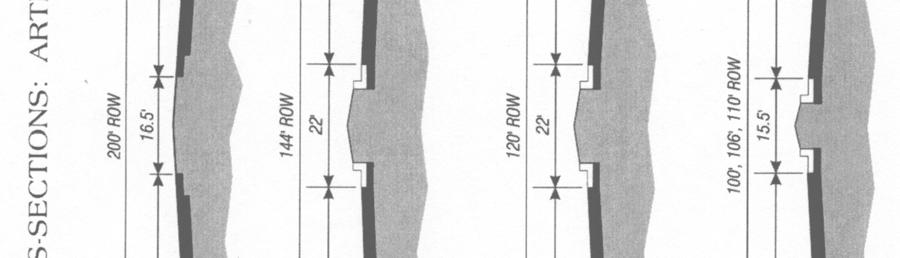
20 Re: 80' minimum right-of-way. The Council adopted a policy that there be no Trafficways on the Broward County Trafficways Plan of less than 80' total right-ofway other than one-way couples, based on information from the Florida Department of Transportation that department would not consider any project less than 80' for federal funding assistance The Council changed reference to cross-section to read "A typical cross section" to clarify that the cross section shown on the Trafficways Plan is an example only The Council amended its October 27, 1977 policy regarding 80' minimum right-ofway, thereby now allowing 70' right-of-way only if corridor is presently built out to either a 4-lane or 5-lane municipal cross section Changed "Other - 6-lanes" Trafficways classification to "Arterials-Major". Added three classifications: 54' and 42' one-way pairs; "Minor Collector" with 70' right-ofway Revised typical cross sections for 80' Collector and 70' Minor Collector. Adopted 94' Collector and cross section Adopted Documentation of the Broward County Trafficways Plan which incorporates policies regarding widths of Trafficways and changes to the legend Adopted 144' Arterial and typical cross section. Revised classifications. Deleted typical cross sections. Deleted list of revisions. Current Legend Limited Access/Controlled 325' Arterial 200' - 144' - 120' 110' - 106' - 100' Collector 94' - 80' - 70' One-Way Pair 54' - 42' A3-2


21 A3-3


22 A3-4


23 A3-5
24 A3-6


25 EXAMPLE CROSS-SECTIONS: Context Sensitive Corridor- Urban Core (CSC-UC) (constrained) A3-7
26 EXAMPLE CROSS-SECTIONS: Context Sensitive Corridor- Urban Core (CSC-UC) (unconstrained) A3-8
 94 ROW")
27 EXAMPLE CROSS-SECTION: Context Sensitive Corridor- Urban Main Street (CSC-UMS) 94 ROW A3-9
")
28 EXAMPLE CROSS-SECTION: Context Sensitive Corridor- Urban Main Street (CSC-UMS) 80 ROW CROSS-SECTION: Context Sensitive Corridor- Urban Residential (CSC-UR) A3-10
29 APPENDIX 4 - LIST OF REVISIONS TO THE BROWARD COUNTY TRAFFIC- WAYS PLAN PRESENT* TRAFFICWAY: Shadowwood Boulevard/Margate Boulevard LIMITS: University Drive to Rock Island Road TRAFFICWAY: State Road A-1-A LIMITS: US 1/Eller Drive to Taylor Road ACTION: Deleted 120' Trafficway TRAFFICWAY: Northwest 48 Street/Wiles Road LIMITS: State Road 7/US 441 to Florida Turnpike ACTION: Realigned 110' Trafficway TRAFFICWAY: Pembroke Road LIMITS: State Road 7/US 441 to US 1 ACTION: Reduced 106' Trafficway to 100' TRAFFICWAY: Hillcrest Drive LIMITS: Washington Street to Park Road TRAFFICWAY: Hollywood Boulevard LIMITS: Florida Turnpike to State Road 7/US 441 ACTION: Increased 120' Trafficway to 132' TRAFFICWAY: I-595/Port Everglades Expressway LIMITS: University Drive to State Road 7/US 441 ACTION: Adopted specific right-of-way plan TRAFFICWAY: Military Circle/Hollywood Boulevard LIMITS: North of Tyler Street to North/South Circle Drive west to south of Tyler Street to North/South Circle Drive east ACTION: Adopted specific right-of-way plan *The Broward County Trafficways Plan was adopted in four sub-areas beginning in 1962 and was combined into one map in For revisions prior to 1983, please contact Council staff. As the chronological listing is updated, Appendix 4 will be printed as a separate document available at no additional cost. A4-1
30 TRAFFICWAY: City Hall Circle/Watson Circle/26 Avenue LIMITS: Polk Street to west of 26 Avenue to Van Buren Street to east of 26 Avenue ACTION: Adopted specific right-of-way plan TRAFFICWAY: Young Circle/US 1/Hollywood Boulevard LIMITS: North of Tyler Street to west of US 1 to south of Harrison Street to east of US 1 ACTION: Adopted specific right-of-way plan TRAFFICWAY: Northeast 10 Street LIMITS: US 1 to State Road A-1-A ACTION: Deleted 120' Trafficway TRAFFICWAY: State Road A-1-A LIMITS: Northeast 10 Street to Dania Beach Boulevard ACTION: Deleted 120' Trafficway TRAFFICWAY: State Road A-1-A LIMITS: Dania Beach Boulevard to Sheridan Street ACTION: Reduced 106' Trafficway to 80' TRAFFICWAY: Dania Beach Boulevard LIMITS: Hollywood city limits to State Road A-1-A ACTION: Reduced 110' Trafficway to 100' TRAFFICWAY: North/South 14 Avenue LIMITS: Sheridan Street to Atlantic Shores Boulevard TRAFFICWAY: Northwest 136 Avenue LIMITS: Sunrise Boulevard to Flamingo Road ACTION: Increased 80' Trafficway to 110' and realigned A4-2
31 TRAFFICWAY: Sawgrass Expressway/Deerfield Expressway LIMITS: State Road 84 to Florida Turnpike ACTION: Adopted specific right-of-way plan TRAFFICWAY: Southwest 10 Street LIMITS: Florida Turnpike to Powerline Road ACTION: Realigned 250' Trafficway TRAFFICWAY: Northwest 8 Street/Cleary Boulevard LIMITS: Southwest 136 Avenue to Hiatus Road ACTION: Increased 80' Trafficway to 106' TRAFFICWAY: Northwest 5 Street LIMITS: University Drive to Northwest 70 Avenue ACTION: Increased 80' Trafficway to 100' TRAFFICWAY: Northwest 65 Avenue LIMITS: Northwest 70 Avenue to Sunrise Boulevard ACTION: Increased 80' Trafficway to 100' TRAFFICWAY: Ramblewood Drive LIMITS: Coral Springs Drive to Atlantic Boulevard TRAFFICWAY: State Road A-1-A LIMITS: US 1/Taylor Street to Griffin Road/Northwest 10 Street ACTION: Deleted 120' Trafficway TRAFFICWAY: McIntosh Road/Griffin Road/Northwest 10 Street LIMITS: US 1 to Eller Drive ACTION: Added 120' Trafficway TRAFFICWAY: Riverside Drive LIMITS: Holmberg Road to Sawgrass Expressway ACTION: Realigned 106' Trafficway A4-3
32 TRAFFICWAY: Nob Hill Road LIMITS: South of State Road 84/I-595 to north section lines of 29 and 30, township 50, range 41 ACTION: Realigned 110' Trafficway TRAFFICWAY: Old Griffin Road LIMITS: Bryan Road to US TRAFFICWAY: Northwest 3/4 Avenues/Dixie Highway LIMITS: Old Griffin Road to Dania Beach Boulevard ACTION: Deleted 42' one-way pair Trafficway TRAFFICWAY: Johnson Street LIMITS: I-75 to west limit of C. B. Smith Park ACTION: Deleted 106' Trafficway TRAFFICWAY: Taft Street LIMITS: Southwest 136 Avenue to Flamingo Road ACTION: Realigned 106' Trafficway TRAFFICWAY: Sheridan Street LIMITS: East of Southwest 148 Avenue to Flamingo Road ACTION: Realigned 200' Trafficway TRAFFICWAY: Southwest 136 Avenue LIMITS: Sheridan Street to Pines Boulevard ACTION: Realigned 110' Trafficway TRAFFICWAY: Southwest 148 Avenue LIMITS: Griffin Road to Sheridan Street ACTION: Added 110' Trafficway TRAFFICWAY: University Parkway/Sawgrass Expressway Extension LIMITS: Palm Beach County Line to Sawgrass Expressway ACTION: Realigned 325' Trafficway A4-4
33 TRAFFICWAY: University Drive LIMITS: Palm Beach County Line to Sawgrass Expressway ACTION: Realigned 200' Trafficway TRAFFICWAY: Riverside Drive LIMITS: Palm Beach County Line to Sawgrass Expressway ACTION: Increased 106' Trafficway to 120' TRAFFICWAY: Rock Island Road LIMITS: Palm Beach County Line to Sawgrass Expressway ACTION: Deleted 110' Trafficway TRAFFICWAY: Holmberg Road LIMITS: Riverside Drive to State Road 7/US 441 ACTION: Realigned 120' Trafficway TRAFFICWAY: Holmberg Road LIMITS: Pine Island Road to University Drive ACTION: Realigned 120' Trafficway TRAFFICWAY: Pine Island Road LIMITS: Palm Beach County Line to Sawgrass Expressway ACTION: Increased 106' Trafficway to 120' and realigned TRAFFICWAY: Airport Road LIMITS: Proposed airport boundary to Nob Hill Road ACTION: Added 110' Trafficway TRAFFICWAY: Nob Hill Road LIMITS: Sawgrass Expressway to University Drive ACTION: Increased 106' Trafficway to 120' and realigned TRAFFICWAY: Nob Hill Road Connector LIMITS: University Drive to Riverside Drive/County Line ACTION: Added 120' Trafficway TRAFFICWAY: Loxahatchee Road LIMITS: Nob Hill Road to Riverside Drive ACTION: Deleted 120' Trafficway A4-5
34 TRAFFICWAY: County Line Road (north) LIMITS: Pine Island Road to Riverside Drive ACTION: Added 80' Trafficway TRAFFICWAY: Hillsboro Boulevard LIMITS: Riverside Drive to State Road 7/US 441 ACTION: Realigned 120' Trafficway TRAFFICWAY: Holmberg Road LIMITS: Pine Island Road to Nob Hill Road ACTION: Deleted 120' Trafficway TRAFFICWAY: County Line Road LIMITS: Pine Island Road to Riverside Drive ACTION: Increased 80' Trafficway to 110' TRAFFICWAY: Southwest 196 Avenue LIMITS: 1750' north of Pines Boulevard to Pines Boulevard ACTION: Deleted 110' Trafficway TRAFFICWAY: Northwest 136 Avenue LIMITS: Sunrise Boulevard to Flamingo Road ACTION: Increased 110' Trafficway and realigned TRAFFICWAY: Southwest 196 Avenue LIMITS: 3300' north of Pines Boulevard to 1750' north of Pines Boulevard ACTION: Deleted 110' Trafficway TRAFFICWAY: Rock Island Road LIMITS: Sawgrass Expressway to Wiles Road ACTION: Deleted 110' Trafficway TRAFFICWAY: Southwest 160 Avenue/Dykes Road LIMITS: Sheridan Street to Miramar Boulevard extended ACTION: Realigned 110' Trafficway A4-6
35 TRAFFICWAY: Southwest 160 Avenue/Dykes Road LIMITS: Sheridan Street to Miramar Boulevard extended ACTION: Increased 110' Trafficway to 120' TRAFFICWAY: State Road 7/US 441 LIMITS: Sunrise Boulevard to State Road 84 ACTION: Decreased 200' Trafficway to 144' mainline/164' expanded intersection TRAFFICWAY: Griffin Road LIMITS: West of Flamingo Road to Florida Turnpike ACTION: Increased 80' Trafficway to 120' specific right-of-way plan TRAFFICWAY: Southwest 24 Street/Nova Drive LIMITS: Nob Hill Road to Pine Ridge Drive TRAFFICWAY: Hollywood Boulevard LIMITS: North/South 21 Avenue to US 1/Young Circle ACTION: Deleted 120' Trafficway TRAFFICWAY: US 1 South/Young Circle West LIMITS: North of Tyler Street to south of Harrison Street ACTION: Deleted 120' Trafficway TRAFFICWAY: Harrison Street LIMITS: South 21 Avenue to South 17 Avenue ACTION: Added 70' Trafficway TRAFFICWAY: Tyler Street LIMITS: North 21 Avenue to North 17 Avenue ACTION: Added 70' Trafficway TRAFFICWAY: Kean Road LIMITS: Oakes Road to Orange Drive TRAFFICWAY: Southwest 206 Avenue LIMITS: Saddle Club Road to Orange Drive ACTION: Deleted 110' Trafficway A4-7
36 TRAFFICWAY: Southwest 208 Avenue LIMITS: Saddle Club Road to Orange Drive ACTION: Added 110' Trafficway TRAFFICWAY: Northwest 8 Street/Cleary Boulevard LIMITS: Sawgrass Expressway to Southwest 136 Avenue ACTION: Realigned 80' Trafficway TRAFFICWAY: Royal Palm Boulevard LIMITS: Sawgrass Expressway to west of Westchester Elementary ACTION: Deleted 106' Trafficway TRAFFICWAY: Southwest 64 Street LIMITS: Southwest 35 Street to County Line Road (south) TRAFFICWAY: Flamingo Road LIMITS: Oakland Park Boulevard to Sunrise Boulevard ACTION: Adopted specific right-of-way plan TRAFFICWAY: Hillsboro Boulevard LIMITS: County Line Road (north) to State Road 7/US 441 ACTION: Realigned 120' Trafficway TRAFFICWAY: Broward Boulevard LIMITS: Southwest 136 Avenue to Flamingo Road ACTION: Increased to 106', realigned, and extended 80' Trafficway TRAFFICWAY: Broward Boulevard LIMITS: Southwest 136 Avenue to Flamingo Road ACTION: Realigned 106' Trafficway TRAFFICWAY: Cypress Creek Road LIMITS: Powerline Road to I-95 ACTION: Increased 110' Trafficway to 156' TRAFFICWAY: Holmberg Road LIMITS: University Drive to Riverside Drive ACTION: Realigned 120' Trafficway A4-8
37 TRAFFICWAY: Flamingo Road LIMITS: Sunrise Boulevard to I-595 ACTION: Adopted specific right-of-way plan TRAFFICWAY: Southwest 30 Avenue LIMITS: State Road 84 to Griffin Road ACTION: Added Trafficway with specific right-of-way plan TRAFFICWAY: Sample Road LIMITS: Sawgrass Expressway to University Drive ACTION: Adopted specific right-of-way plan incorporating the City s Master Parking Plan TRAFFICWAY: Southeast 2 Street LIMITS: US 1 to Southeast 3 Avenue TRAFFICWAY: Southeast 3 Avenue LIMITS: Southeast 2 Street to Southeast 3 Street TRAFFICWAY: Southeast 3 Street LIMITS: Southeast 3 Avenue to Southeast 5 Avenue TRAFFICWAY: Southwest 26 Street LIMITS: Hiatus Road to Nob Hill Road TRAFFICWAY: Northwest 64 Avenue LIMITS: Commercial Boulevard to Northwest 44 Street ACTION: Deleted 106' Trafficway TRAFFICWAY: Collins Road LIMITS: Southwest 30 Avenue to Tram Road ACTION: Added 80' Trafficway A4-9
38 TRAFFICWAY: Southwest 42 Street LIMITS: Southwest 30 Avenue to Ravenswood Road ACTION: Added 80' Trafficway TRAFFICWAY: Oakes Road LIMITS: Kean Road to State Road 7/US TRAFFICWAY: Reese Road LIMITS: State Road 84/I-595 to Oakes Road TRAFFICWAY: Oakes Road LIMITS: Davie Road to Reese Road TRAFFICWAY: Southwest 36 Street LIMITS: University Drive to Southwest 76 Avenue TRAFFICWAY: Southwest 76 Avenue LIMITS: Southwest 36 Street to Stirling Road TRAFFICWAY: Southwest 58 Avenue LIMITS: Griffin Road to Stirling Road TRAFFICWAY: Southwest 70 Avenue LIMITS: Griffin Road to Stirling Road TRAFFICWAY: Southwest 82 Avenue LIMITS: Griffin Road to Stirling Road TRAFFICWAY: Southwest 36 Street LIMITS: Flamingo Road to Pine Island Road ACTION: Deleted 110' Trafficway effective A4-10
39 TRAFFICWAY: Southwest 39 Street LIMITS: University Drive to College Avenue TRAFFICWAY: Northwest 21 Avenue LIMITS: Prospect Road to Northwest 26 Avenue ACTION: Reduced 106' Trafficway to 94' and realigned TRAFFICWAY: Powerline Road LIMITS: Sample Road to Cypress Creek Road ACTION: Adopted specific right-of-way plan TRAFFICWAY: State Road 7/US 441 LIMITS: State Road 84/I-595 to Griffin Road ACTION: Adopted specific right-of-way plan TRAFFICWAY: Northwest 8 Street/Cleary Boulevard LIMITS: Southwest 136 Avenue to Flamingo Road ACTION: Reduced 106' Trafficway to 94' and realigned TRAFFICWAY: Northwest 8 Street/Cleary Boulevard LIMITS: Flamingo Road to Hiatus Road ACTION: Deleted 106' Trafficway TRAFFICWAY: Northeast 62 Street/Cypress Creek Road LIMITS: Northeast 18 Avenue to US TRAFFICWAY: Northeast 56 Street LIMITS: Dixie Highway to US TRAFFICWAY: State Road A-1-A LIMITS: Sunrise Boulevard to Seabreeze Boulevard ACTION: Reduced State Road A-1-A 100' Trafficway between Sunrise Boulevard and Seville Street to 85'; reduced State Road A-1-A 100' Trafficway between Seville Street and Seabreeze Boulevard to 73'; and added 85' Trafficway to the west of State Road A-1-A between Seville Street and Seabreeze Boulevard generally following the alignment of Seabreeze Boulevard A4-11
40 TRAFFICWAY: North 26 Avenue LIMITS: Stirling Road to Sheridan Street TRAFFICWAY: Northwest 120 Way/Northwest 44 Street LIMITS: Oakland Park Boulevard to Hiatus Road and 106' Trafficway TRAFFICWAY: Hiatus Road LIMITS: Sawgrass Expressway to Northwest 44 Street ACTION: Deleted 106' Trafficway TRAFFICWAY: North/South 26 Avenue - Northwest/Southwest 8 Avenue LIMITS: Sheridan Street to Dade County Line TRAFFICWAY: Northeast/Northwest 3 Street LIMITS: Ansin Boulevard to Northeast 14 Avenue TRAFFICWAY: Southwest 136 Avenue LIMITS: Griffin Road to Sheridan Street ACTION: Deleted 110' Trafficway TRAFFICWAY: Northwest 21 Avenue LIMITS: Northwest 26 Street to Northwest 19 Street ACTION: Reduced 106' Trafficway to 94' and realigned TRAFFICWAY: Southeast 5 Avenue LIMITS: Dania Beach Boulevard to Sheridan Street ACTION: Deleted 106' Trafficway TRAFFICWAY: Andrews Avenue LIMITS: New River to Davie Boulevard ACTION: Reduced 106' Trafficway to 88' A4-12
41 TRAFFICWAY: Arvida Parkway LIMITS: I-75 to Weston Road ACTION: Reduced 200' Trafficway to 130' TRAFFICWAY: Indian Trace LIMITS: I-75 to Bonaventure Boulevard ACTION: Reduced 150' Trafficway to 120' TRAFFICWAY: Saddle Club Road LIMITS: US 27 to Indian Trace ACTION: Reduced 150' Trafficway to 120' TRAFFICWAY: South Post Road LIMITS: Saddle Club Road to Weston Road ACTION: Reduced 110' Trafficway to 94' TRAFFICWAY: No Name Road LIMITS: US 27 to Arvida Parkway ACTION: Deleted 110' Trafficway TRAFFICWAY: Southwest 208 Avenue LIMITS: Saddle Club Road to Griffin Road ACTION: Deleted 110' Trafficway TRAFFICWAY: Southwest 26 Street LIMITS: US 27 to South Post Road ACTION: Reduced 110' Trafficway to 94' TRAFFICWAY: Southwest 196 Avenue LIMITS: South Post Road to Griffin Road ACTION: Deleted 110' Trafficway TRAFFICWAY: Southwest 36 Street LIMITS: US 27 to South Post Road ACTION: Reduced 110' Trafficway to 94' A4-13
42 TRAFFICWAY: Southeast 16/17 Avenues LIMITS: Broward Boulevard to Las Olas Boulevard ACTION: Deleted 42' one-way pair Trafficway TRAFFICWAY: Bass Creek Road LIMITS: Southwest 148 Avenue to Hiatus Road ACTION: Deleted 110' Trafficway TRAFFICWAY: Hiatus Road LIMITS: Pembroke Road to the Flamingo Road Connector ACTION: Realigned 106' Trafficway TRAFFICWAY: McNab Road LIMITS: Dixie Highway to US 1 ACTION: Deleted 106' Trafficway TRAFFICWAY: Southwest 136 Avenue LIMITS: Miramar Parkway to Honey Hill Road ACTION: Deleted 110' Trafficway TRAFFICWAY: Southwest 148 Avenue LIMITS: Miramar Parkway to Honey Hill Road ACTION: Added 94' Trafficway TRAFFICWAY: Miramar Boulevard LIMITS: Flamingo Road to Palm Avenue ACTION: Increased 80' Trafficway to 100' and realigned TRAFFICWAY: Miramar Boulevard LIMITS: Southwest 148 Avenue to Flamingo Road TRAFFICWAY: Powerline Road LIMITS: Hillsboro Boulevard to Sample Road ACTION: Reduced 200' Trafficway to 144' A4-14
43 TRAFFICWAY: Sample Road LIMITS: US 1 to Northeast 23 Avenue TRAFFICWAY: Davie Road LIMITS: Nova Drive to Stirling Road ACTION: Reduced 106' Trafficway to 80' TRAFFICWAY: State Road A-1-A LIMITS: Palm Beach County Line to the Hillsboro Inlet ACTION: Adopted specific right-of-way plan TRAFFICWAY: Taft Street LIMITS: North 68 Avenue to North 66 Avenue ACTION: Reduced 106' Trafficway to 80' TRAFFICWAY: Sample Road LIMITS: Sawgrass Expressway to University Drive ACTION: Deleted Master Parking Plan and adopted 106' Trafficway TRAFFICWAY: North/South 35 Avenue LIMITS: Taft Street to Washington Street TRAFFICWAY: University Parkway/Sawgrass Expressway Extension LIMITS: Palm Beach County Line to Sawgrass Expressway ACTION: Reduced 325' Trafficway to 240' Trafficway and realigned TRAFFICWAY: Pine Island Road LIMITS: Palm Beach County Line to Sawgrass Expressway ACTION: Realigned 120' Trafficway TRAFFICWAY: Nob Hill Road LIMITS: Sawgrass Expressway to University Drive ACTION: Realigned 120' Trafficway TRAFFICWAY: Nob Hill Road LIMITS: North of University Parkway/Sawgrass Expressway Extension to Nob Hill Road ACTION: Deleted 110' Trafficway A4-15
44 TRAFFICWAY: County Line Road LIMITS: Conservation Area to Pine Island Road ACTION: Added 120' Trafficway TRAFFICWAY: Northeast 14 Avenue LIMITS: Northeast 9 Street to Hallandale Beach Boulevard TRAFFICWAY: Southeast 9 Street LIMITS: Dixie Highway to US TRAFFICWAY: Southwest 36 Street LIMITS: Southwest 154 Avenue (Shotgun Road) to Flamingo Road ACTION: Deleted 110' Trafficway TRAFFICWAY: Northwest 15 Street/Northwest 10 Street LIMITS: MLK Jr. Boulevard (Hammondville Rd.) to Old Dixie ACTION: Deleted 106' Trafficway TRAFFICWAY: Collins Road LIMITS: Southwest 30 Avenue to Ravenswood Road TRAFFICWAY: Tram Road LIMITS: State Road 84 to Stirling Road TRAFFICWAY: Southwest 148 Avenue LIMITS: Sheridan Street to Griffin Road ACTION: Deleted 110' Trafficway TRAFFICWAY: Southwest 145 Avenue LIMITS: Miramar Parkway to Pembroke Road ACTION: Added Trafficway at 94' A4-16
45 TRAFFICWAY: Southwest 136 Avenue LIMITS: Miramar Parkway to Sheridan Street ACTION: Deleted 110' Trafficway TRAFFICWAY: Taft Street LIMITS: Southwest 136 Avenue to Flamingo Road ACTION: Deleted 106' Trafficway TRAFFICWAY: Southwest 36 Street LIMITS: University Drive to Pine Island Road ACTION: Deleted 110' Trafficway TRAFFICWAY: Riverside Drive LIMITS: Holmberg Road to Palm Beach County ACTION: Deleted 120' Trafficway TRAFFICWAY: Southwest 148 Avenue LIMITS: State Road 84 to Griffin Road ACTION: Deleted 110' Trafficway between Southwest 14 Street and Griffin Road, and reduced Trafficway to 94' between State Road 84 and Southwest 14 Street TRAFFICWAY: State Road A-1-A LIMITS: A-1-A Connector between Southeast 17 Street and Eller Drive at the interchange with Interstate 595 ACTION: Deleted 120' Trafficway TRAFFICWAY: Southwest 196 Avenue LIMITS: Griffin Road to approximately 3300' North of Pines Boulevard ACTION: Deleted 110' Trafficway TRAFFICWAY: Southwest 148 Avenue LIMITS: Miramar Parkway to Honey Hill Road ACTION: Deleted 94' Trafficway A4-17
46 TRAFFICWAY: Southwest 145 Avenue LIMITS: Pembroke Road to Miramar Parkway ACTION: Realigned 94' Trafficway TRAFFICWAY: Blount Road LIMITS: Sample Road to Copans Road ACTION: Added 84' Trafficway TRAFFICWAY: Sawgrass Expressway Extension LIMITS: Sawgrass Expressway to Palm Beach County Line ACTION: Deleted 240' Trafficway TRAFFICWAY: Honey Hill Road LIMITS: Flamingo Road/Southwest 124 Avenue to the Homestead Extension of the Florida Turnpike (HEFT) ACTION: Deleted 110' Trafficway TRAFFICWAY: Southwest 172 Avenue LIMITS: South Post Road to Griffin Road ACTION: Deleted 110' Trafficway TRAFFICWAY: Southwest 172 Avenue LIMITS: Griffin Road to Sheridan Street ACTION: Realigned and reduced Trafficway to 94' TRAFFICWAY: Hiatus Road LIMITS: McNab Road to Northwest 44 Street ACTION: Added 106' Trafficway between McNab Road and Commercial Boulevard, and added 94' Trafficway between Commercial Boulevard and Northwest 44 Street TRAFFICWAY: Hiatus Road LIMITS: Southwest 14 Street to Sheridan Road ACTION: Reduced Trafficway to 94' A4-18
47 TRAFFICWAY: Stirling Road LIMITS: US 27 to Flamingo Road ACTION: Deleted 110' Trafficway TRAFFICWAY: Southwest 14 Street LIMITS: Hiatus Road to Weston Road ACTION: Reduced Trafficway to 94' TRAFFICWAY: Northwest 4 Street/Northwest 69 Avenue LIMITS: Broward Boulevard to Northwest 76 Avenue ACTION: Deleted 100' Trafficway TRAFFICWAY: Taft Street LIMITS: US 1 to North 14 Avenue TRAFFICWAY: Bass Creek Road LIMITS: Southwest 148 Avenue to Southwest 184 Avenue ACTION: Realigned 110' Trafficway TRAFFICWAY: Hiatus Road LIMITS: Southwest 14 Street to Griffin Road ACTION: Deleted 94' Trafficway TRAFFICWAY: Miramar Parkway LIMITS: Southwest 184 Avenue to Southwest 208 Avenue ACTION: Realigned 120' Trafficway TRAFFICWAY: Honey Hill Road LIMITS: Homestead Extension of the Florida Turnpike to US 27 ACTION: Deleted 110' Trafficway TRAFFICWAY: Southwest 160 Avenue LIMITS: Bass Creek Road to Honey Hill Road ACTION: Reduced Trafficway to 80' A4-19
Broward County Land Use Plan: Environmentally Sensitive Lands
 US27 HIATUS RD NW 136TH AVE SW 136TH AVE FLAMINGO RD LYONS RD CYPRESS RD Broward County Land Use Plan: Environmentally Sensitive Lands PALM BEACH COUNTY N USHY 27 284939 334939 045039 095039 44 CONSERVATION
State Highway System Key Sheet Broward County ²
 Broward County ² GOVT RD/SNAKE RD 3 0 3 Indian River St. Lucie Martin Palm Beach Broward I-75 " On System Roads #" 10 3293 Map Preparation Date: 5/2/2016 3:53:29 PM 86075000 #" 75 US 27 Inset - 3 Inset
10 Broward County Fire Rescue Ft. Laud-Hollywood Int l Airport 4150 SW 11 th Terrace Fort Lauderdale, FL
 FIRE CHIEFS ASSOCIATION OF BROWARD COUNTY MUTUAL AID & COMMUNICATIONS COMMITTEE FIRE STATION DESIGNATION NUMBERS STATION ADDRESS PHONE NUMBERS 01 Dania Fire Rescue 954-924-3710 116 W Dania Beach Blvd.
BROWARD COUNTY MANATEE PROTECTION ZONES
 MANATEE PROTECTION ZONES For description of zone boundaries see: 68C-22.00 F.A.C for State Manatee Protection Zones last amended /4/20 For infomation please call or write to: Fish and Wildlife Conservation
BrowardNEXT Topic Item Web Link Source Year
 BrowardNEXT Topic Item Web Link Source Year Intergovernmental Coordination Population QuickFacts http://www.census.gov/quickfacts/table/pst120 US Census Bureau 2010 214/12011 Intergovernmental Coordination
AGENCY: Federal Emergency Management Agency, DHS. SUMMARY: Flood hazard determinations, which may include additions or
 This document is scheduled to be published in the Federal Register on 08/01/2014 and available online at http://federalregister.gov/a/2014-18229, and on FDsys.gov 1 Billing Code 9110-12-P DEPARTMENT OF
May 1, 2015 Chuck McGinness, BROWARD COUNTY TRAFFIC IMPACT REPORT May 1 through May 8, 2015
 From: McGinness, Charles To: McGinness, Charles Subject: FDOT Broward County Traffic Impact Report 05 01 15 through 05 08 15 Date: Friday, May 01, 2015 3:10:15 PM Attachments: image001.png May 1, 2015
MATTHEW G. MCALLISTER Director (561)
") SOUTH FLORIDA INDUSTRIAL TEAM CUSHMAN & WAKEFIELD AVAILABLE PROPERTIES February 2017 CUSHMAN & WAKEFIELD 515 E. Las Olas Boulevard, Suite 860 Fort Lauderdale, FL 33301 225 NE Mizner Boulevard, Suite 300
SOUTH FLORIDA INDUSTRIAL TEAM CUSHMAN & WAKEFIELD AVAILABLE PROPERTIES February 2017 CUSHMAN & WAKEFIELD 515 E. Las Olas Boulevard, Suite 860 Fort Lauderdale, FL 33301 225 NE Mizner Boulevard, Suite 300
Toll Rates for Florida Turnpike System and Florida Department of Transportation (FDOT) Toll Facilities. South Florida
 Toll Facilities. South Florida") Toll Rates for Florida Turnpike System and Florida Department of Transportation (FDOT) Toll Facilities South Florida Effective: October 29, 207 S.R. 82 (HEFT) Miami-Dade and Broward Counties S.R. 82 (HEFT)
Toll Rates for Florida Turnpike System and Florida Department of Transportation (FDOT) Toll Facilities South Florida Effective: October 29, 207 S.R. 82 (HEFT) Miami-Dade and Broward Counties S.R. 82 (HEFT)
Schedule ROUTE. Weekend. Broward County Transit
 For more details on our fares please visit our web site at Broward.org/BCT or call customer service: 954.357.8400. Reading a Timetable - It s Easy 1. The map shows the exact bus route. 2. Major route intersections
November 21, 2012 Barbara Kelleher, (954)
") November 21, 2012 Barbara Kelleher, (954) 777-4090 barbara.kelleher@dot.state.fl.us BROWARD COUNTY TRAFFIC IMPACT REPORT November 26 to November 30, 2012 FORT LAUDERDALE -- Construction and maintenance-related
November 21, 2012 Barbara Kelleher, (954) 777-4090 barbara.kelleher@dot.state.fl.us BROWARD COUNTY TRAFFIC IMPACT REPORT November 26 to November 30, 2012 FORT LAUDERDALE -- Construction and maintenance-related
BROWARD COUNTY PUBLIC SCHOOLS
 Assignments Department Elementary School Atlantic West Margate Coconut Creek 812 812 100.0% Banyan Westpine Piper 764 764 100.0% Bayview Sunrise Fort Lauderdale 547 547 100.0% Bennett Sunrise Fort Lauderdale
BROWARD COUNTY TRAFFIC IMPACT REPORT March 13 through March 20, March 13, 2015 Chuck McGinness,
 From: McGinness, Charles To: McGinness, Charles Subject: FDOT Broward County Traffic Impact Report 03 13 15 through 03 20 15 Date: Friday, March 13, 2015 2:43:29 PM Attachments: image001.png BROWARD COUNTY
Schedule ROUTE. Weekday. Broward County Transit
 For more details on our fares please visit our web site at Broward.org/BCT or call customer service: 954.357.8400. Reading a Timetable - It s Easy 1. The map shows the exact bus route. 2. Major route intersections
May 16, 2014 Chuck McGinness, (954) BROWARD COUNTY TRAFFIC IMPACT REPORT May 16 through May 23, 2014
 BROWARD COUNTY TRAFFIC IMPACT REPORT May 16 through May 23, 2014") May 16, 2014 Chuck McGinness, (954) 777-4090 chuck.mcginness@dot.state.fl.us BROWARD COUNTY TRAFFIC IMPACT REPORT May 16 through May 23, 2014 FORT LAUDERDALE -- Construction and maintenance-related lane
May 16, 2014 Chuck McGinness, (954) 777-4090 chuck.mcginness@dot.state.fl.us BROWARD COUNTY TRAFFIC IMPACT REPORT May 16 through May 23, 2014 FORT LAUDERDALE -- Construction and maintenance-related lane
CITY OF MARGATE TRANSPORTATION ELEMENT
 CITY OF MARGATE TRANSPORTATION ELEMENT Revised: August 2004 TABLE OF CONTENTS Page No. INTRODUCTION DESCRIPTION OF EXISTING TRANSPORTATION SYSTEM Roadway System Significant Parking Facilities Public Transit
Leasing Brochure. Park Plaza Shopping Center 1150 N. Federal Highway, Pompano Beach, Florida Under Construction - Coming Very Soon
 Park Plaza Shopping Center 1150 N. Federal Highway, Pompano Beach, Florida 33062 Leasing Brochure Under Construction - Coming Very Soon Exclusive Leasing Broker 2048 East Sample Road, Lighthouse Point,
Potential 2014 Hurricane Debris Management Sites
 US27 I95 Potential 2014 Hurricane Debris Management Sites 95 72 ² 0 1 2 3 4 SOUTHWEST RANCHES PEMBROKE PINES MIRAMAR SOUTHWEST RANCHES 61 9 7 4 CORAL SPRINGS 6 5 TAMARAC SUNRISE COOPER CITY 63 18 17 8
October 31, 2014 Chuck McGinness, (954)
") From: McGinness, Charles To: McGinness, Charles Subject: FDOT Broward County Traffic Impact Report 10 31 14 through 11 07 14 Date: Friday, October 31, 2014 2:59:04 PM Attachments: image002.png October
From: McGinness, Charles To: McGinness, Charles Subject: FDOT Broward County Traffic Impact Report 10 31 14 through 11 07 14 Date: Friday, October 31, 2014 2:59:04 PM Attachments: image002.png October
Welcome to the Downtown Fort Lauderdale Neighborhood Working Group Meeting. First meeting june 17, 2010
 Welcome to the Downtown Fort Lauderdale Neighborhood Working Group Meeting First meeting june 17, 2010 State of the Project Draft Environmental Impact Statement Study Phase This study is NOT the final
Schedule ROUTE441BREEZE ROUTE. Weekdays. Broward County Transit
 For more details on our fares please visit our web site at Broward.org/BCT/faresandpasses.htm or call customer service: 54.357.8400. Reading A Timetable - It s Easy 1. The map shows the exact bus route.
12, 14 and 16 York Street - Amendments to Section 16 Agreement and Road Closure Authorization
 REPORT FOR ACTION 12, 14 and 16 York Street - Amendments to Section 16 Agreement and Road Closure Authorization Date: April 27, 2018 To: Toronto and East York Community Council From: Senior Strategic Director,
Schedule Effective 10/9/16
 For more details on our fares please visit our web site at Broward.org/BCT or call customer service: 954.357.8400. Reading a Timetable - It s Easy 1. The map shows the exact bus route. 2. Major route intersections
BROWARD COUNTY MUNICIPALITIES MEETING/ TRAINING ROOMS NUMBER OF TOTAL ROOMS ROOM TYPE- CAPACITY CITY OF COOPER CITY
 BROWARD COUNTY MUNICIPALITIES MEETING/ TRAINING CITY OF COOPER CITY 1 COOPER CITY COMMUNITY CENTER 9000 SW 50th Place, Cooper City 33328 2 COOPER CITY- CITY HALL 9090 SW 50th Place, Cooper City 33328 3
Schedule ROUTE. All Week. Broward County Transit
 For more details on our fares please visit our web site at Broward.org/BCT or call customer service: 954.357.8400. Reading a Timetable - It s Easy 1. The map shows the exact bus route. 2. Major route intersections
Schedule ROUTE. Weekend1. Broward County Transit
 For more details on our fares please visit our web site at Broward.org/BCT or call customer service: 954.357.8400. Reading a Timetable - It s Easy. The map shows the exact bus route. 2. Major route intersections
Schedule ROUTE ROUTE. Weekend. Broward County Transit
 For more details on our fares please visit our web site at Broward.org/BCT/faresandpasses.htm or call customer service: 954.357.8400. Reading A Timetable - It s Easy 1. The map shows the exact bus route.
Schedule ROUTE. All Week. Broward County Transit
 For more details on our fares please visit our web site at Broward.org/BCT or call customer service: 954.357.8400. Reading A Timetable - It s Easy 1. The map shows the exact bus route. 2. Major route intersections
See List PER ACRE $18,270, See List
 3:55:43 PM 2009 TRIM DR-420 Proposed Rates 8/10/2009 TOTAL OPERATING DEBT SERV ROLL-BACK County Commission 5.7163 5.2163 0.5000 5.5319 Unincorporated 2.3353 2.3353 0.0000 2.5389 County Fire/Rescue 2.5224
CityStats Southeast Florida Trends
 CityStats Southeast Florida Trends 2017 Research Analyst Liane Schrader, CAE Center for Municipal Research & Innovation Florida League of Cities CityStats Southeast Florida Regional Trend Analysis 100%
Customer Service:
 Customer Service: 1-877-905-0500 MIAMI - DADE COUNTY Medical Doctors House Calls 1-855-668-8798 8:00am - 5:00pm 1770 NE Miami Gardens Dr. Unit #1 North Miami Beach, FL 33179 (305) 949-4141 12555-C Biscayne
SUMMER VILLAGE OF SILVER SANDS. Municipal Development Plan
 SUMMER VILLAGE OF SILVER SANDS Municipal Development Plan Bylaw 253-2014 Adopted August 22, 2014 Summer Village of Silver Sands Municipal Development Plan Bylaw No. 253-2014 Page 2 1 INTRODUCTION 1.1 SETTING
Schedule ROUTE. All Week. Broward County Transit
 For more details on our fares please visit our web site at Broward.org/BCT or call customer service: 954.357.8400. Reading a Timetable - It s Easy. The map shows the exact bus route. 2. Time points are
Northwest Triangle. Redevelopment Proposal. Property Acquisition, Engineering, and Demolition. December, 2005 REDEVELOPMENT AUTHORITY OF THE
 Northwest Triangle Redevelopment Proposal Property Acquisition, Engineering, and Demolition December, 2005 REDEVELOPMENT AUTHORITY OF THE CITY OF YORK York City Redevelopment Authority 14 West Market Street,
$4, PER UNIT $176, $4, CR Coral Bay. $1, PER UNIT $1,316, $1, CS Coral Springs Imp.
 5:12:10 PM 2010 TRIM DR-420 Proposed Rates 8/6/2010 TOTAL OPERATING DEBT SERV ROLL-BACK County Commission 5.6765 5.2256 0.4509 5.5976 Unincorporated 2.3353 2.3353 0.0000 2.7561 County Fire/Rescue 2.5224
Please find the attached letter and resolution from the MPO Chair, Commissioner Richard Blattner. The original letter has been mailed to you.
 From: Singer Kathy [mailto:singerk@browardmpo.org] Sent: Thursday, March 17, 2016 5:15 PM To: Kiar, Martin Cc: Barrocas, Scott ; Henry, Bertha ;
NCUTCD Proposal for Changes to the Manual on Uniform Traffic Control Devices
 1 2 3 4 5 6 7 8 9 10 11 12 13 14 15 16 17 18 19 20 21 22 23 24 25 26 27 28 29 30 31 32 TECHNICAL COMMITTEE: ITEM NUMBER: TOPIC: ORIGIN OF REQUEST: AFFECTED SECTIONS OF MUTCD: NCUTCD Proposal for Changes
CityStats Southeast Florida Trends
 CityStats Florida Trends 2018 Research Analyst Liane Giroux, CAE Center for Municipal Research & Innovation Florida League of Cities CityStats Florida Regional Trend Analysis Municipal Revenue Sources
Schedule ROUTE. All Week. Broward County Transit
 For more details on our fares please visit our web site at Broward.org/BCT or call customer service: 954.357.8400. Reading A Timetable - It s Easy. The map shows the exact bus route. 2. Major route intersections
Metrolinx Projects: Temporary Delegation for Long- Term Road Closures
 PW29.1 REPORT FOR ACTION Metrolinx Projects: Temporary Delegation for Long- Term Road Closures Date: April 24th, 2018 To: Public Works and Infrastructure Committee From: General Manager, Transportation
PURPOSE AND NEED (CONCURRENCE POINT 1) NEW CANADA ROAD PROJECT FROM STATE ROUTE 1 (U.S. HIGHWAY 70) TO U.S. INTERSTATE 40
 NEW CANADA ROAD PROJECT FROM STATE ROUTE 1 (U.S. HIGHWAY 70) TO U.S. INTERSTATE 40") PURPOSE AND NEED (CONCURRENCE POINT 1) NEW CANADA ROAD PROJECT FROM STATE ROUTE 1 (U.S. HIGHWAY 70) TO U.S. INTERSTATE 40 Project Description The primary purpose of this project is to improve the major
PURPOSE AND NEED (CONCURRENCE POINT 1) NEW CANADA ROAD PROJECT FROM STATE ROUTE 1 (U.S. HIGHWAY 70) TO U.S. INTERSTATE 40 Project Description The primary purpose of this project is to improve the major
FOR IMMEDIATE RELEASE Fiorella Teodista January 5, 2018 SOUTH FLORIDA AND TREASURE COAST WEEKLY LANE CLOSURES AND WORK ZONE ADVISORY
 TRAFFIC ADVISORY FOR IMMEDIATE RELEASE Fiorella Teodista 954-934-1130 January 5, 2018 SOUTH FLORIDA AND TREASURE COAST WEEKLY LANE CLOSURES AND WORK ZONE ADVISORY FORT LAUDERDALE Florida s Turnpike announces
Schedule ROUTE. All Week. Broward County Transit
 For more details on our fares please visit our web site at Broward.org/BCT or call customer service: 954.357.8400. Reading A Timetable - It s Easy 1. The map shows the exact bus route. 2. Major route intersections
Schedule. ROUTE19 All Week. Broward County Transit
 For more details on our fares please visit our web site at Broward.org/BCT or call customer service: 954.357.8400. Reading A Timetable - It s Easy 1. The map shows the exact bus route. 2. Major route intersections
Proposed Bicycle Lanes on Yonge Street from Queens Quay to Front Street
 STAFF REPORT ACTION REQUIRED Proposed Bicycle Lanes on Yonge Street from Queens Quay to Front Street Date: March 12, 2007 To: From: Toronto and East York Community Council Director, Transportation Infrastructure
TREASURE COAST REGIONAL PLANNING COUNCIL M E M O R A N D U M. To: Council Members AGENDA ITEM 9
 TREASURE COAST REGIONAL PLANNING COUNCIL M E M O R A N D U M To: Council Members AGENDA ITEM 9 From: Date: Subject: Staff October 21, 2016 Council Meeting South Dixie Highway Corridor Improvement Plan
MEMORANDUM. Lynn Hayes LSA Associates, Inc.
 MEMORANDUM To: Lynn Hayes LSA Associates, Inc. Date: May 5, 217 From: Zawwar Saiyed, P.E., Senior Transportation Engineer Justin Tucker, Transportation Engineer I Linscott, Law & Greenspan, Engineers LLG
SECTION 4(f) PROPERTIES [RECODIFIED AS 49 U.S.C. 303(C)]
![SECTION 4(f) PROPERTIES [RECODIFIED AS 49 U.S.C. 303(C)]](/thumbs/79/80109893.jpg "SECTION 4(f) PROPERTIES [RECODIFIED AS 49 U.S.C. 303(C)]") 5.D.2 SECTION 4(f) PROPERTIES [RECODIFIED AS 49 U.S.C. 303(C)] The Federal statute that governs impacts in this category is commonly known as the Department of Transportation (DOT) Act of 1966, Section
5.D.2 SECTION 4(f) PROPERTIES [RECODIFIED AS 49 U.S.C. 303(C)] The Federal statute that governs impacts in this category is commonly known as the Department of Transportation (DOT) Act of 1966, Section
DEPARTMENT OF PLANNING, COMMUNITY & ECONOMIC DEVELOPMENT
 DEPARTMENT OF PLANNING, COMMUNITY & ECONOMIC DEVELOPMENT DATE: December 11, 2015 TO: FROM: SUBJECT: City Council Kevin Cricchio, AICP Associate Planner Department of Planning, Community & Economic Development
Lake Erie Commerce Center Traffic Analysis
 LOCATION: East of NYS Route 5 at Bayview Road Town of Hamburg Erie County, New York PREPARED BY: Wendel Companies 140 John James Audubon Parkway Suite 200 Amherst, New York 14228 January 2012 i ii Table
MESA COUNTY DEPARTMENT OF PUBLIC WORKS Administration - Building - Engineering Road and Bridge Traffic - Planning - Solid Waste Management
 MESA COUNTY DEPARTMENT OF PUBLIC WORKS Administration - Building - Engineering Road and Bridge Traffic - Planning - Solid Waste Management 200 S. Spruce St. P.O. Box 20,000 Grand Junction, Colorado 81502-5022
Schedule ROUTE. Monday - Saturday. Broward County Transit
 For more details on our fares please visit our web site at Broward.org/BCT or call customer service: 954.357.8400. Reading A Timetable - It s Easy 1. The map shows the exact bus route. 2. Major route intersections
CITY COUNCIL AGENDA MEMORANDUM
 To: Mayor and City Council From: Charles Ozaki, City and County Manager Prepared By: Kevin Standbridge, Deputy City and County Manager Katie Allen, City and County Engineer David Shinneman, Community Development
Schedule Effective 1/18/15
 For more details on our fares please visit our web site at broward.org/bct or call customer service: 954.357.8400. Reading A Timetable - It s Easy. The map shows the exact bus route. 2. Major route intersections
Schedule Effective 4/23/17
 For more details on our fares please visit our web site at Broward.org/BCT or call customer service: 954.357.8400. Reading A Timetable - It s Easy 1. The map shows the exact bus route. 2. Major route intersections
Community Development
 Community Development City & Borough of Juneau Community Development 155 S. Seward Street Juneau, AK 99801 (907) 586 0715 Phone (907) 586 4529 Fax DATE: February 11, 2016 TO: FROM: Planning Commission
Resolution No.: Introduced: July 24, 2018 Adopted: July 24, 2018
 Resolution No.: 18-1215 Introduced: July 24, 2018 Adopted: July 24, 2018 COUNTY COUNCIL FOR MONTGOMERY COUNTY, MARYLAND SITTING AS THE DISTRICT COUNCIL FOR THAT PORTION OF THE MARYLAND-WASHINGTON REGIONAL
Action Recommendation: Budget Impact:
 City of Fayetteville Staff Review Form 2017-0692 Legistar File ID 12/19/2017 City Council Meeting Date - Agenda Item Only N/A for Non-Agenda Item Andrew Garner Submitted By 12/1/2017 Submitted Date Action
Other Principle Arterials Minor Arterial Major Collector Minor Collector Local
 CHAPTER 10 TRANSPORTATION Introduction The system of public roads in East Pikeland Township is decidedly rural in character. Since the 1984, the road network has remained much the same, with the addition
CHAPTER FIVE ENVIRONMENTAL CONSEQUENCES
 CHAPTER FIVE ENVIRONMENTAL CONSEQUENCES Pursuant to the environmental documentation requirements of FAA Order 1050.1E, Environmental Impacts, Policies and Procedures, this chapter describes the reasonably
The Transportation Corridor Overlay District
 The Transportation Corridor Overlay District The Transportation Corridor Overlay District is a policy framework under which certain potentially beneficial development proposals may be considered, given
 BROWARD DEANERY 1 ALL SAINTS (954) 467-6496 333 Tarpon Dr. Ft. Lauderdale, FL 33301 4 INTERCESSION (954) 763-5986 501 N.W. 17 St. Ft. Lauderdale, FL 33311 I-95 to Broward Blvd. exit. Go east on Broward
MONTGOMERY COUNTY PLANNING DEPARTMENT THE MARYLAND-NATIONAL CAPITAL PARK AND PLANNING COMMISSION
 MONTGOMERY COUNTY PLANNING DEPARTMENT THE MARYLAND-NATIONAL CAPITAL PARK AND PLANNING COMMISSION Three Sisters Road: Abandonment No. AB740 MCPB Item No. 11 Date: 5-1-14 Katherine Holt, Senior Planner,
Schedule ROUTE. All Week. Broward County Transit
 For more details on our fares please visit our web site at Broward.org/BCT or call customer service: 954.357.8400. Reading a Timetable - It s Easy 1. The map shows the exact bus route. 2. Major route intersections
DRAFT GENERAL IMPLEMENTATION PLAN AND SPECIFIC IMPLEMENTATION PLAN MIDDLETON MUNICIPAL AIRPORT MOREY FIELD. Revised 12/12/03
 DRAFT GENERAL IMPLEMENTATION PLAN AND SPECIFIC IMPLEMENTATION PLAN MIDDLETON MUNICIPAL AIRPORT MOREY FIELD Revised 12/12/03 As recommended for approval by the Plan Commission General Project Description
Schedule ROUTE. Weekend. Broward County Transit
 For more details on our fares please visit our web site at Broward.org/BCT or call customer service: 954.357.8400. Reading A Timetable - It s Easy. The map shows the exact bus route. 2. Major route intersections
Rural Rustic Road Program
 Virginia Department of Transportation s Rural Rustic Road Program Prepared by the Local Assistance Division Virginia Department of Transportation 1401 East Broad Street Richmond, Virginia 23219 Michael
INTERLOCAL AGREEMENT FOR TRAIL DESIGN AND CONSTRUCTION BETWEEN THE CITY OF AUSTIN
 1 2 3 4 5 6 7 8 9 10 11 12 13 14 15 16 17 18 19 20 21 22 23 24 25 26 27 28 29 30 31 32 33 34 35 36 37 38 39 40 41 42 43 44 45 46 47 48 INTERLOCAL AGREEMENT FOR TRAIL DESIGN AND CONSTRUCTION BETWEEN THE
1.2 Corridor History and Current Characteristics
 SECTION 1 Description and Background of Study Area 1.1 Introduction This preliminary engineering report was prepared for the Alaska Department of Transportation and Public Facilities (ADOT&PF). It is part
BROWARD COUNTY PUBLIC SCHOOLS School Boundaries Department Data Source: TERMS Student Information Systems Twentieth Day Enrollment
 NORTH AREA Elementary Schools Atlantic West 938 938 739 747 619 Challenger 1,234 1,116 817 851 923 Coconut Creek 958 929 873 845 769 Coral Park 720 645 589 598 610 Coral Springs 768 728 720 677 652 Country
Community Development Committee
 C Community Development Committee For the Metropolitan Council meeting of October 31, 2012 Committee Report Item:2012-316 ADVISORY INFORMATION October 16, 2012 Date Prepared: Subject: Intercity Regional
Schedule ROUTE. Monday - Saturday. Broward County Transit
 For more details on our fares please visit our web site at Broward.org/BCT or call customer service: 954.357.8400. Reading a Timetable - It s Easy 1. The map shows the exact bus route. 2. Major route intersections
Madison Metro Transit System
 Madison Metro Transit System 1101 East Washington Avenue Madison, Wisconsin, 53703 Administrative Office: 608 266 4904 Fax: 608 267 8778 TO: FROM: SUBJECT: Plan Commission Timothy Sobota, Transit Planner,
Section 106 Update Memo #1 Attachment D. Traffic Diversion & APE Expansion Methodology & Maps
 Section 106 Update Memo #1 Attachment D Traffic Diversion & APE Expansion Methodology & Maps I-65/I-70 North Split Interchange Reconstruction Project (Des. Nos. 1592385 & 1600808) Traffic Diversion and
TIMETABLE ROUTE. Customer Service. Holiday Bus Service. Effective10/31/10. Fares. Fare Deals. 10 Ride Pass: 10 Rides any time, any day.
 TIMETABLE ROUTE 60 Monday - Sunday Effective10/31/10 Broward Central Terminal to Highway 441 and N. W. 15 Street via Andrews Avenue and Martin Luther King Jr. Boulevard/ Coconut Creek Parkway A service
Fort Lauderdale City Commission Transit Presentation. July 21, 2009 CAR
 Fort Lauderdale City Commission Transit Presentation July 21, 2009 CAR 109 0932 Agenda Overview City Transit Vision Commission Direction 2035 LRTP Long Range Transportation Plan THOR Transit/Housing Oriented
SAN FRANCISCO MUNICIPAL TRANSPORTATION AGENCY
 THIS PRINT COVERS CALENDAR ITEM NO. : 10.2 DIVISION: Sustainable Streets BRIEF DESCRIPTION: SAN FRANCISCO MUNICIPAL TRANSPORTATION AGENCY Amending Transportation Code, Division II to prohibit parking on
Quiet Zone along FEC Corridor. Paul Calvaresi Regional Transportation Planner
 Quiet Zone along FEC Corridor Paul Calvaresi Regional Transportation Planner Calvaresip@browardmpo.org About the Quiet Zone Throughout all of Broward County on the FEC Tracks Deerfield Beach Pompano Beach
Section II. Planning & Public Process Planning for the Baker/Carver Regional Trail began in 2010 as a City of Minnetrista initiative.
 Section II Planning & Public Process Planning for the began in 2010 as a City of initiative. city staff began discussions with the Park District on the possibility of a north/south regional trail connection
Nova Southeastern University Joint-Use Library Agreement: Review of Public Usage
 Exhibit 1 Nova Southeastern University Joint-Use Library Agreement: Robert Melton, CPA, CIA, CFE, CIG County Auditor Audit Conducted by: Gerard Boucaud, CISA, Audit Manager Dirk Hansen, CPA, Audit Supervisor
Miami/Ft. Lauderdale
 010018 - Miami/Ft. Lauderdale Description: I-95 WS 0.2mi S/O Stirling Rd F/S - 1 TAB Panel ID: 355514 City: HOLLYWOOD Latitude: 26.045 Media Type: Bulletin State: FL Longitude: -80.163 Dimensions: 19'
This is an electronic copy. Format and font may vary from the official version. Attachments may not appear. BEFORE THE PUBLIC UTILITY COMMISSION
 ENTERED FEB 28 2003 This is an electronic copy. Format and font may vary from the official version. Attachments may not appear. BEFORE THE PUBLIC UTILITY COMMISSION OF OREGON WA 47 In the Matter of the
CITY PLANNING COMMISSION June 22, 2011, Calendar No. 27
 CITY PLANNING COMMISSION June 22, 2011, Calendar No. 27 IN THE MATTER OF IN THE MATTER OF an application, submitted by the Department of Transportation, pursuant to Sections 197-c and 199 of the New York
Schedule ROUTE. All Week. Broward County Transit
 For more details on our fares please visit our web site at Broward.org/BCT or call customer service: 954.357.8400. Reading A Timetable - It s Easy 1. The map shows the exact bus route. 2. Major route intersections
Memorandum. Roger Millar, Secretary of Transportation. Date: April 5, Interstate 90 Operations and Mercer Island Mobility
 Memorandum To: From: The Honorable Dow Constantine, King County Executive; The Honorable Ed Murray, City of Seattle Mayor; The Honorable Bruce Bassett, City of Mercer Island Mayor; The Honorable John Stokes,
Schedule ROUTE. All Week. Broward County Transit
 For more details on our fares please visit our web site at Broward.org/BCTor call customer service: 954.357.8400. Reading a Timetable - It s Easy 1. The map shows the exact bus route. 2. Major route intersections
Site Location and Setting
 Memorandum Date: To: From: Subject: Kristy Le, Gary Black Steve Orem Santa Teresa County Park Historic Area Traffic and Parking Study Hexagon Transportation Consultants, Inc. has completed a traffic and
FNORTHWEST ARKANSAS WESTERN BELTWAY FEASIBILITY STUDY
 FNORTHWEST ARKANSAS WESTERN BELTWAY FEASIBILITY STUDY EXECUTIVE SUMMARY The 2030 Northwest Arkansas Regional Transportation Plan developed by the Northwest Arkansas Regional Planning Commission (NWARPC)
DISTRICT EXPRESS LANES ANNUAL REPORT FISCAL YEAR 2017 JULY 1, 2016 JUNE 30, FloridaExpressLanes.com
 DISTRICT EXPRESS LANES ANNUAL REPORT FISCAL YEAR 2017 JULY 1, 2016 JUNE 30, 2017 FloridaExpressLanes.com This page intentionally left blank. TABLE OF CONTENTS List of Figures... ii List of Tables.... ii
Continental Divide National Scenic Trail Legislative History and Planning Guidance
 Continental Divide National Scenic Trail Legislative History and Planning Guidance Legislation, Policy, and Direction Regarding National Scenic Trails The National Trails System Act, P.L. 90-543, was passed
Proposed Official Plan Amendment 41 to the Region of York Official Plan
 COMMITTEE OF THE WHOLE NOVEMBER 18, 2002 REGION OF YORK OFFICIAL PLAN AMENDMENT 41 THE OAK RIDGES MORAINE CONSERVATION PLAN Recommendation The Commissioner of Planning recommends: 1. That the City of Vaughan
FEASIBILITY CRITERIA
 This chapter describes the methodology and criteria used to evaluate the feasibility of developing trails throughout the study areas. Land availability, habitat sensitivity, roadway crossings and on-street
ORDINANCE NO. 14,723
 ORDINANCE NO. 14,723 AN ORDINANCE providing that general property taxes levied and collected each year on all property located within the Beaverdale Commercial Area Urban Renewal Area in the City of Des
NIAGARA MOHAWK POWER CORPORATION. Procedural Requirements
 NIAGARA MOHAWK POWER CORPORATION Procedural Requirements Initial Effective Date: November 9, 2015 Table of Contents 1. Introduction 2. Program Definitions 3. CDG Host Eligibility Provisions 4. CDG Host
COUNCIL REPORT Meeting Date: December 10, 2013
 Subject: Highway 63/881 Corridor Area Structure Plan Amendment Bylaw No. 13/037 APPROVALS: Felice Mazzoni, Director Henry Hunter, Executive Director Glen Laubenstein, Chief Administrative Officer COUNCIL
Schedule ROUTE. All Week. Broward County Transit
 For more details on our fares please visit our web site at Broward.org/BCT or call customer service: 954.357.8400. Reading A Timetable - It s Easy 1. The map shows the exact bus route. 2. Major route intersections
Schedule ROUTE. All Week. Broward County Transit
 For more details on our fares please visit our web site at Broward.org/BCT or call customer service: 954.357.8400. Reading A Timetable - It s Easy 1. The map shows the exact bus route. 2. Major route intersections
Comparison Between Old and New ALUC Plans
 A P P E N I X H Comparison Between Old and New ALUC Plans OVERVIEW This Placer County Airport Land Use Compatibility Plan (ALUCP) sets forth land use compatibility criteria for the environs of Auburn Municipal,
ISTRIO MUNICIPALITY OF MUSKOK
 ISTRIO MUNICIPALITY OF MUSKOK.- -..-.. -.-... -- PLANNING AND ECONOMIC DEVELOPMENT DEPARTMENT 70 PINE STREET, BRACEBRIDGE, ONTARIO PI L 1 N3 Telephone (705) 645-2231 OR 1-800-461-4210 (705 area code) Fax
PLANNING COMMISSION AGENDA REPORT May 10, Members of the Planning Commission. Joyce Parker-Bozylinski, Contract Planner
 PLANNING COMMISSION AGENDA REPORT May 10, 2007 TO: FROM: PROPOSAL: APPLICANT: RECOMMENDATION: Members of the Planning Commission Joyce Parker-Bozylinski, Contract Planner Approval of the Calabasas Trails