COUNTRYSIDE ESTATE MANAGEMENT REVIEW
|
|
|
- Colleen Jordan
- 5 years ago
- Views:
Transcription

1 COUNTRYSIDE ESTATE MANAGEMENT REVIEW Prepared: March
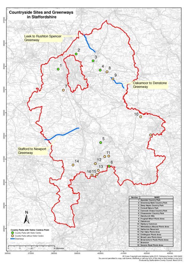
2 Key Facts and Figures Site Details 1.1 The countryside estate totals about 6000 acres comprising: 6 main country parks; 9 picnic areas and a number of smaller sites; 3 disused railway lines. 1.2 All of the main country parks have protected habitats and sites. 1.3 Cannock Chase Country Park is the largest of the main country parks and is designated a Special Area of Conservation, lying within the Cannock Chase Area of Outstanding Natural Beauty. 1.4 Approximately 3,000,000 million visits each year. Staffing Arrangements 1.5 The management, and maintenance, of the estate is mostly delivered in-house by: Rural Access Manager 2 Head Rangers 1 Works Unit Manager 14 Rangers 17 Estate Workers 1 Development Officer 1.6 The Works Unit Team is trained and skilled to carry out most of the practical work on the Estate and also, well-resourced in terms of plant and equipment. Therefore, external contractors are only employed for large-scale woodland management and engineering works. 1.7 The Service Area is also supported by a team of Environmental Specialists and a significant voluntary contribution of about 25,000 hours per annum (equivalent to an additional 13 FTEs). Financial Information The combined budget for running the countryside estate and rights of way service is: Capital - 180,000 per annum Net expenditure - 1, 875,980 Income C. 418,200 per annum (includes 185,000 from HLS schemes). Contract Arrangements The cleaning and maintenance of the on-site buildings and the operation of the catering facilities at Cannock Chase and Chasewater Visitor Centres are under contract to Entrust. 2
3 3
4 LIST OF SITES Size (ha) Page No. Country Parks (6) Cannock Chase Country Park 1,311 5 Apedale Community Country Park Consall Nature Park Deep Hayes Country Park Greenway Bank Country Park Chasewater including Norton Bog Picnic Areas (10) Froghall 3 17 Oakamoor 8 19 Sevens Road, Cannock Wood Hanbury Common 2 23 Brownshore Lane, Essington Chillington Hanchurch Hills 7 29 Fair Oak, Essington 4 31 Hatherton Reservoir, Cheslyn Hay Disused Railway Walks (3) Stafford to Newport Oakamoor to Denstone Leek to Rushton Sites on which Public Access is Not Promoted Broad Lane, Essington Wimblebury Road, Cannock 3 43 Branston 2 45 Appendix 1 Summary Details of Countryside Sites 47 4
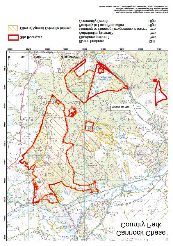
5 Cannock Chase Country Park Electoral Wards: Stafford Trent Valley Members: Len Bloomer Hednesford and Rawley Geoffrey Martin Brereton and Ravenshill Alan Dudson Etching Hill and Heath George Adamson Christine Mitchell Parish Councils: Berkswich, Colwich, Brocton, and Brindley Heath. Size: 1,311 ha Description Perhaps the largest Country Park in England, Cannock Chase Country Park lies within the smallest mainland Area of Outstanding Natural Beauty. It is the jewel within the Countryside Service. It has the highest international recognition as a wildlife site a Special Area of Conservation (SAC). It is also nationally known and attracts over 2 million visitors each year. We are legally obliged to maintain the site in good condition. Its most important feature is the open heathland but it also contains Ancient Woodlands and some conifer plantations. Much of the associated wildlife is both rare and important. There is a thriving Visitor Centre and café at Marquis Drive attracting thousands of visitors. It is also the base for the Ranger Service and depot for the Works Unit. Other buildings/features include an Education Centre, a reconstructed Great War Hut and children s play area. The whole site is heated by a newly installed wood burning boiler which is fuelled by timber from the Chase. We work closely with the Forestry Commission to manage visitors. We provide a full Ranger Service, including education provision, a guided walks and event programme and facilities for the disabled across the whole site. Opportunities / Liabilities This is a high cost site to maintain but grant aid has been gained through HLS for the conservation works. Income is also generated through sales at the Visitor Centre. The Phytophthora disease on the bilberry has been expensive to try to control. There are two pay and display car parks, one at the Centre and the other at Milford Common (the other main honey pot area). The cafe is managed by Entrust. The ability to raise finance from the site has to be balanced against the potentially detrimental effect this would have on the wildlife and habitat and landscape. There are many of the usual liabilities associated with high public use, such as track, barrier and car park repairs, grass cutting etc. but also this area is subject to mining fissures and large scale heathland fires. The Chase also provides timber for other county council sites. 5
6 6

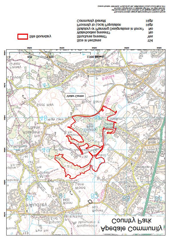
7 Apedale Community Country Park, Newcastle Electoral Ward: Audley and Chesterton Member: Ann Beech Parish Councils: Audley Rural Size: 154 ha Description The Park is a reclaimed opencast site, and is a mixture of old and recently planted woodland, together with open grass pasture. It has great views over the Potteries and Cheshire Plain. A new Visitor Centre, Apedale Energy Station was erected in 2011; the old centre is still leased out as a workshop for groups with disabilities. It is on the edge of the large conurbations of Knutton and Chesterton and is heavily used by local people who walk onto the site. It is also popular with visitors, especially walking groups, who use the network of good tracks. There are two rangers based on the site and also, the Newcastle Countryside Project (now managed by Wigan Leisure and Culture Trust) works in and around the park with volunteers, especially with groups with disabilities. Opportunities / Liabilities Two new wind turbines generate electricity for the Centre and for sale to the grid. There is a listed structure (grade 2), Watermills Tower, which is in good condition. The paddocks are grazed with cattle which create excellent habitat for ground nesting birds such as lapwings. There are no protected areas but grant aid has been gained through HLS for some conservation works. Adjacent to the site, and sharing its access off Loomer Road, is the Apedale Heritage Centre and Moseley Railway Trust. 7
8 8

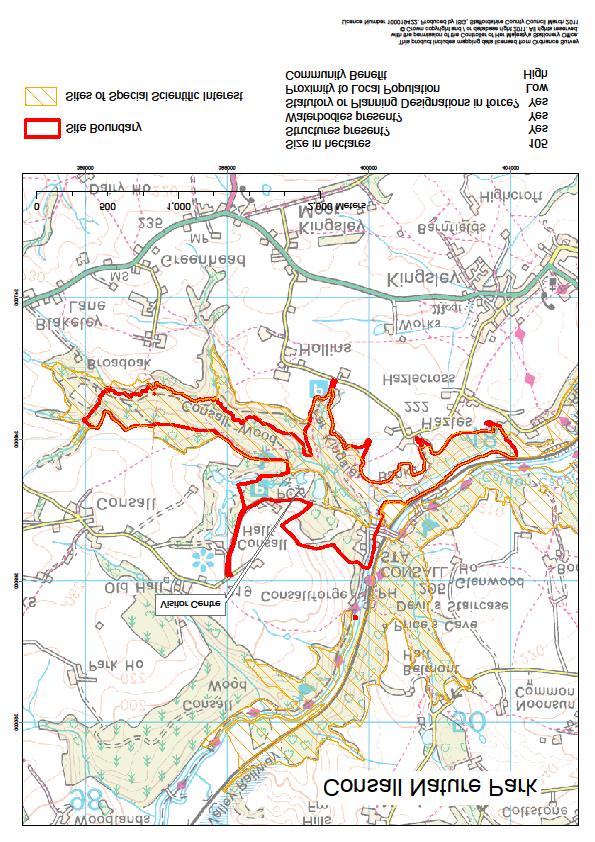
9 Consall Nature Park, Wetley Rocks, Cellarhead Electoral Ward: Churnet Valley Member: Mike Worthington Parish Councils: Consall, Kingsley Size: 105 ha Description Consall Nature Park was established in the heavily wooded Churnet Valley in the 1980s. It has a busy Visitor Centre which is popular with day visitors and school groups. Most of the park is part of the Churnet Valley SSSI noted for the semi-natural woodland. The difficult access along a single narrow track and its high conservation value has led to it being deliberately underpromoted. Nevertheless, visitors pack the car park most weekends and the lack of parking is an issue.. Two Rangers are based on site assisted by volunteers. Opportunities / Liabilities The two pools on the site fall under the new Reservoir Legislation. Currently both are available for day fishing. The main track gives access to the Churnet Valley Railway, Black Lion Pub and a number of residential properties. The track has proved costly to maintain in the past but is now in reasonably good condition. There is some coppice management but the woodland could be managed to produce wood fuel. There is some scope for grant aid due to the SSSI status. 9
10 10

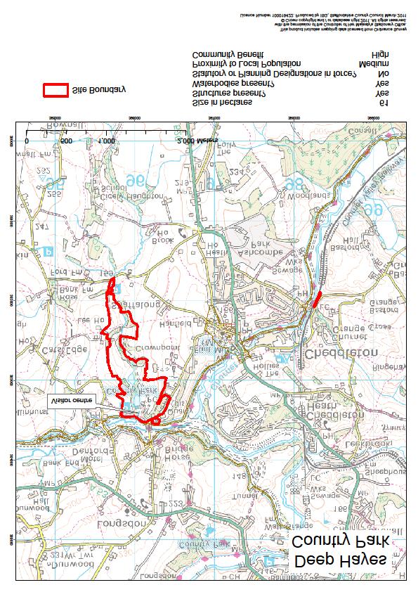
11 Deep Hayes Country Park, Cheddleton, Nr. Leek Electoral Ward: Cheddleton Member: Mike Worthington Parish Council: Cheddleton CP Size: 61 ha Description Deep Hayes Country Park was created in the 1970s when the single large reservoir was converted into three smaller pools for safety reasons. There are a number of trails inside and outside of the Park. One Ranger is based in the small Visitor Centre. There is a large surfaced car park and the Park is popular with local visitors. A thriving volunteer group assists with day to day management. There are high quality, flower rich meadows at the top of the site. Opportunities / Liabilities The pools which do not fall under the new Reservoir legislation still require regular inspection and maintenance. There are no protected areas and limited scope to gain grant aid on this site. The larger pool is leased to a local angling club. The Park attracts large numbers of visitors for its size. 11
12 12

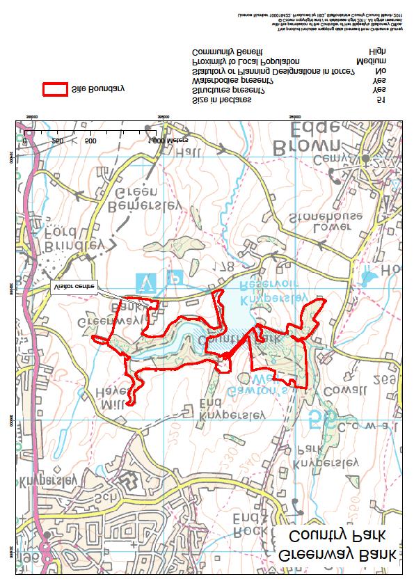
13 Greenway Bank Country Park, Knypersley, Nr. Biddulph Electoral Ward: Biddulph and South Endon Member: Kevin James Jackson Parish Councils: Biddulph CP, Brown Edge CP Size: 55 ha Description Greenway Bank Country Park is based on an historical landscape and surrounds two reservoirs; the Serpentine (owned by SCC) and Knypersley Reservoir (owned by Canals & Rivers Trust). The water from these reservoirs feeds into the canal network. One Ranger is based at the newly refurbished Visitor Centre. There is also a small courtyard, play area and car park. The site is a popular and well established venue for visitors and numerous volunteers help with all aspects of the park. Opportunities / Liabilities The Serpentine reservoir which is leased to a local angling club requires regular inspection and maintenance. Phytophthora ramorum (a notifiable plant disease) has been found on the Rhododendrons and regular monitoring and treatment is required. Funding for this work has been met via a Forestry Commission Woodland Grant (WGS) to date. Apart from this WGS, there is little likelihood of further grant aid for the site. There is a Grade II* listed building, the Warders Tower, on the site and a use for this building is being sought. However, it requires extensive works which are likely to be costly. The woodland could be managed to provide wood fuel. Warders Tower 13
14 14

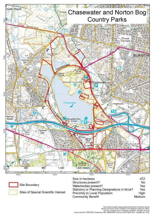
15 Chasewater Country Park including Norton Bog Electoral Ward: Burntwood South Member: Jeffrey Sheriff Parish Council: Norton Canes, Burntwood Size: 472 ha Description The County Council assumed responsibility for Chasewater Country Park in 2011 following major repairs to the reservoir dam. Chasewater Innovation Centre is at the entrance to the Country Park. The Innovation Centre offers visitor information and conferencing facilities and a changing programme of exhibitions, activities and events. The Park also has a café, children s play area and a number of trails. The site supports a number of organisations offering power boating, sailing, a heritage steam railway and an outdoor education centre. The Country Park links with land formerly known as Norton Bog which was established as a countryside site following reclamation of the slurry pits of old coal workings. The Norton Bog area contains a pool which falls under the Mines and Quarries legislation. There are no buildings or car parks on this part of the site and most visitors walk to it from Chasewater and Norton Canes. The water in the pool is high quality and the reclaimed landscape and tracks are developing well. Opportunities / Liabilities The Reservoir dam was repaired in 2010 and the reservoir and pool on the land at Norton Bog require regular inspection and maintenance. Most of the land is designated as a Site of Special Scientific Interest but grant aid has been gained through HLS for the site conservation works. Income is generated via the business interests and the Innovation Centre which help to offset the site s operating costs and there is a Development Plan in place. The café is managed by Entrust. 15
16 16

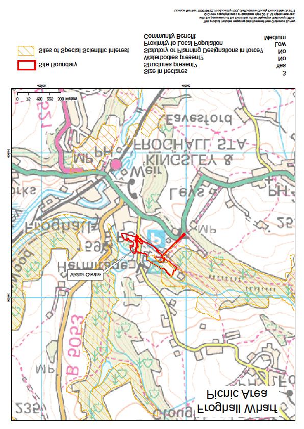
17 Froghall Picnic Area, Froghall Electoral Wards: Churnet Valley Members: Gill Heath Leek Rural Mike Worthington Parish Councils: Kingsley and Ipstones Size: 3 ha Description Two existing canal side buildings were converted into an interesting Visitor Centre on the renovated canal basin. There is a toilet block and large car park. Froghall lies in the heart of the Churnet Valley at the end of the Cauldon Branch Canal, and for the moment, the Churnet Valley Railway. It is ideally placed to tell the story of the development of the Industrial Revolution as it was the centre for coal, limestone and iron working. The trails from the Centre follow old plateways. There are two lime kilns from different ages. Opportunities / Liabilities The large car park is well used by walkers as there are numerous routes along the canal and into the surrounding countryside. One Ranger is based at the Centre. The kilns are listed structures and a watercourse is culverted through one of them and under the site. 17
18 18
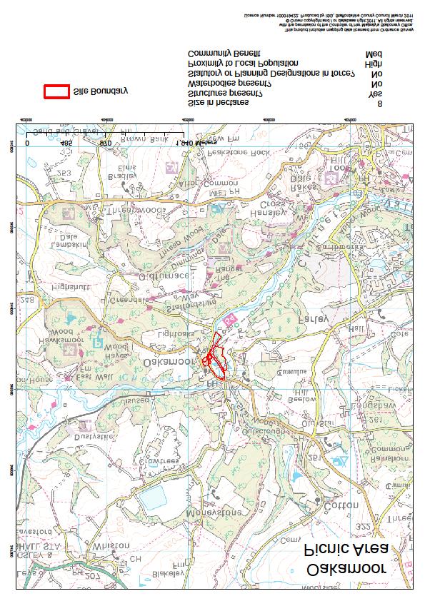
19 Oakamoor Picnic Area Electoral Ward: Churnet Valley Member: Mike Worthington Parish Council: Oakamoor CP Size: 8ha Description This Picnic Area is located at the western end of the Oakamoor to Denstone railway line. It is very popular as a starting point for walkers wishing to visit other sites in the Churnet Valley owned by Forestry Commission, Staffordshire Wildlife Trust and National Trust. At Oakamoor, there is an open grass area with picnic benches, a large car park and a toilet block. It is also well used by cyclists. Opportunities / Liabilities The Oakamoor Tunnel is part of the site, although closed to public access. It is currently in good condition but requires routine structural inspections and could be expensive if repairs were required. There are two bridges over the river which require routine inspection and maintenance and would be expensive if they needed repair. 19
20 20
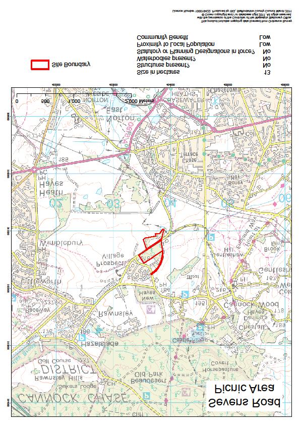
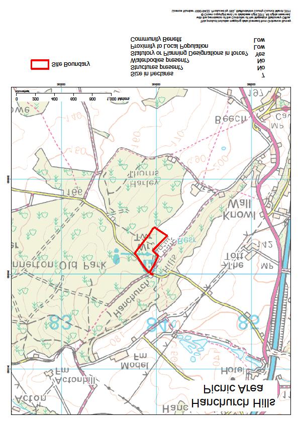
21 Sevens Road Picnic Area, Cannock Wood Electoral Ward: Hednesford & Rawnsley Members: George Adamson Christine Mitchell Parish Council: Unparished Size: 13 ha Description The site is split by a road; one side was used as a demonstration woodland by the Forest of Mercia and is now quite heavily wooded. The other side is mainly open grassland which adjoined the former Bleak House Opencast Site; this side contains a car park which is closed because of anti-social behaviour problems and has often been used in the past by travellers. Opportunities / Liabilities The site receives few visitors. It is some distance from the nearest residential properties which might make it suitable for noisy pastimes, e.g. quad biking (although this might bring its own problems). There are no water bodies or structure on site. 21
22 22
23 Hanbury Common Picnic Area, Hanbury, East Staffordshire Electoral Ward: Dove Member: Bob Fraser Parish Council: Hanbury Size: 2 ha Description This small isolated site is on the side of a hill giving wonderful views over the Trent Valley. It is popular with the local community. The Parish Council has organised volunteer days to improve the site to create tracks, benches and viewpoints. Opportunities / Liabilities There is no water or structures on the site and parking is limited. 23

24 24
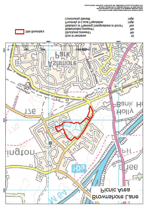
25 Brownshore Lane Picnic Area, Essington Electoral Ward: Cheslyn Hay Essington & Great Wyrley Members: Kath Perry Mike Lawrence Parish Council: Essington Size: 10 ha Description This site is enclosed by housing on all sides. It was gifted to the County Council by the Vernon Estate for the benefit of the local community. It contains two pools which are managed in partnership with the parish council. The parish bailiff also acts to protect the site and clear litter. It is an extremely important feature in the village and is very well used. There is an area of close mown grass for games and a wildlife meadow. Opportunities / Liabilities The site is a local recreational resource and very well used by the local community. 25
26 26
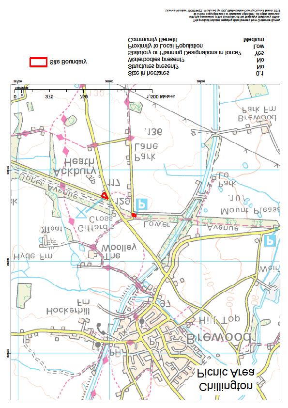
27 Chillington Car Parks Electoral Ward: Brewood Member: Mark Sutton Parish Councils: Brewood and Coven Size: 0.1 ha Description This site consists of two small car parks which are leased to the County Council from the Chillington Estate. They were created to prevent the ad hoc parking in the local lanes by people walking the Staffordshire Way. The Estate carries out most of the routine management (litter picking, etc.). Very low scale works are required to keep these car parks in good order and they provide very useful facilities for walkers. Opportunities / Liabilities These car parks have very few liabilities and are needed to ensure that the previous dangerous parking in the local lanes does not reoccur. 27
28 28
29 Hanchurch Hills, Hanchurch, Newcastle Electoral Ward: Eccleshall Member: Frank Chapman Parish Council: Swynnerton Size: 7 ha Description The site consists of a small picnic area within the conifer woodland of Hanchurch Hills. It is bounded by open Forestry Commission woodland and privately owned land. It has a long track to the only car park in that area. The wider site (including Forestry Commission land) is popular with walkers and horse-riders. Opportunities / Liabilities The very few features make it relatively easy to maintain but the long track does require constant attention. The woodland could be managed to provide a limited mount of wood fuel. 29
30 30
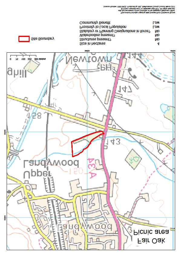
31 Fair Oak, Essington Electoral Ward: Cheslyn Hay, Essington & Great Wyrley Members: Mike Lawrence Kath Perry Parish Councils: Essington and Great Wyrley Size: 4 ha Description This site came to the County Council as part of some reclamation works in the1970s. The low hill gives views over the local countryside and the West Midlands beyond. The access to the site is shared with a travelling caravan site. It is some distance from residential properties and is therefore not well used. Opportunities / Liabilities Its location makes it unsuitable for use as a picnic area/countryside site but also makes it unattractive for any other use. 31
32 32
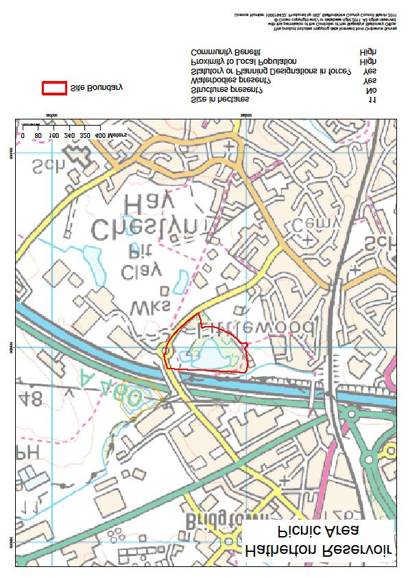
33 Hatherton Reservoir, Cheslyn Hay Electoral Ward: Cheslyn Hay, Essington & Great Wyrley Members: Mike Lawrence Kath Perry Parish Council: Cheslyn Hay Size: 12 ha Description This small site on the edge of two villages comprises tracks and woodlands around a partially filled reservoir. The M6 Toll route has reduced the size of the site and the pool, making it less attractive to anglers). The pool falls under the new reservoir legislation, although it is considered to be low risk. The site is well used by local people and dog walkers. The Parish Council and a local volunteer group have been working to improve the site as it is prone to low level anti-social behaviour. Opportunities / Liabilities The water body requires routine inspection and maintenance. The County Council will soon gain another adjacent area of land, Redland Clay Pit, as compensation for the land lost when building the M6 Toll. The Redland site is designated as a Site of Special Scientific Interest. 33
34 34
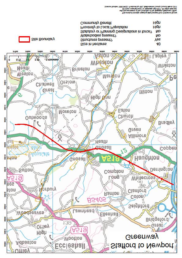
35 Stafford to Newport Greenway Electoral Ward: Gnosall and Doxey Member: Mark Winnington Parish Councils: Stafford Town, Hyde Lea, Seighford, Haughton, Gnosall and Forton. Size: 40 ha, approximately 9 miles Description The Greenway has been developed on the old Stafford to Newport railway line. It provides easy walking and riding for cyclists and horses through attractive countryside and is a very popular route. The route has been formally surfaced and now forms part of the National Cycle Network (NCN 55). It is also part of The Way for the Millennium which links Newport with Burton upon Trent. Access can be gained at a number of locations along its length. There are many structures along the line; bridges, culverts, car parks etc. that need routine inspection and maintenance. The county council is responsible for maintenance of the fencing. The surface, vegetation, car parks and routes onto the line require constant attention. 35
36 36
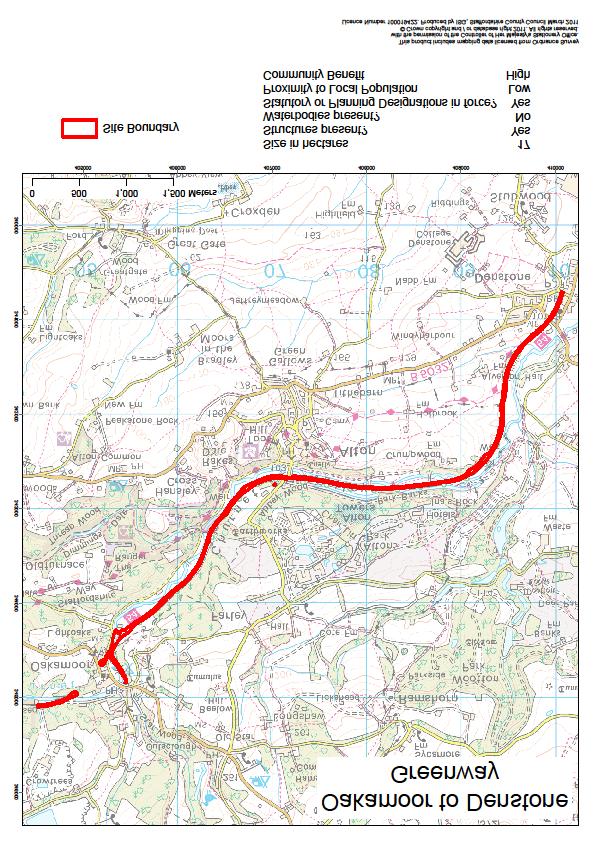
37 Oakamoor to Denstone Greenway Electoral Ward: Uttoxeter Rural Members: Phillip Atkins Mike Worthington Parish Councils: Denstone, Alton, Farley and Oakamoor. Size: Approximately 4.2 miles Description The disused railway line follows the attractive Churnet Valley for 4.2 miles. At Oakamoor, there are large car parks and a new toilet block. It is a very popular route for visitors. It is well used by cyclists and also part of the route is available to horse riders. Opportunities / Liabilities There are many structures along the route which require routine inspection and regular maintenance. The county council is responsible for the fencing. The grass areas are regularly maintained. The Oakamoor tunnel is part of the site, although closed to public access. It is currently in good condition but requires routine structural inspections. There has been some speculation for many years about the restoration of either, or both, the railway and canal along this route. 37
38 38
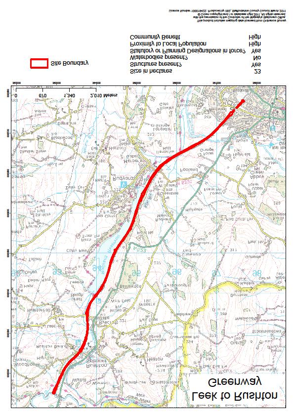
39 Leek to Rushton Greenway Electoral Ward Leek Rural Members: Gill Heath Leek South Charlotte Atkins Parish Councils: Leek, Longsdon, Horton, Rushton Size: Approximately 5.6 miles Description The Greenway runs for 5.6 miles from the north of Leek to the County boundary at the River Dane. It is used primarily by walkers and at low level by cyclists. Horse-riding is not encouraged as part of the route, along the side of Rudyard Lake, is shared with a mini-railway. Rudyard has been a tourist venue since Victorian times and many visitors use the car park to visit the Lake and surrounding venues. Opportunities / Liabilities This site also includes the old railway tunnel under Leek which is not accessible for the public but still requires routine safety inspections. There is a large number of structures, bridges, culverts, etc. which require inspection and maintenance. The county council is responsible for the maintenance of the fencing. The railway brings in many visitors. The Rudyard area is a Conservation Area. 39
40 40
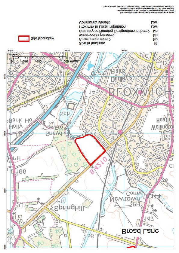
41 Broad Lane, Essington Electoral Ward: Cheslyn Hay, Essington & Great Wyrley Members: Kath Perry Mike Lawrence Parish Council: Essington Size: 16 ha Description The site was part of the Broad Lane Opencast Site and was managed by the Forest of Mercia until recently. It is on the very edge of the West Midlands border. It is a flat site with young tree plantations and a limited number of informal tracks. It suffers from anti-social behaviour. Opportunities / Liabilities The site is in the Green Belt. 41
42 42
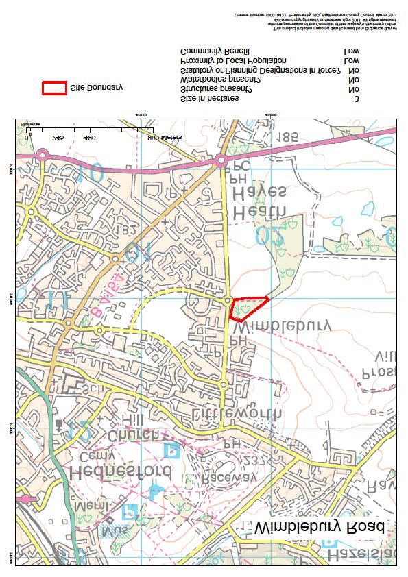
43 Wimblebury Road, Wimblebury Electoral Ward: Cannock Villages Member: Diane Todd Parish Council: Heath Hayes and Wimblebury Size: 3 ha Description This is a small wooded mound left largely untouched since the Bleak House Opencast Site closed. It was managed by the Forest of Mercia until recently for low level informal access and minor woodland management. There are no features of interest and access to the site is difficult. It is therefore not well used. Opportunities / Liabilities Opportunity to develop this site is limited and there has been no interest by local people to assist with its maintenance. There are no major liabilities attached to the site.. 43
44 44
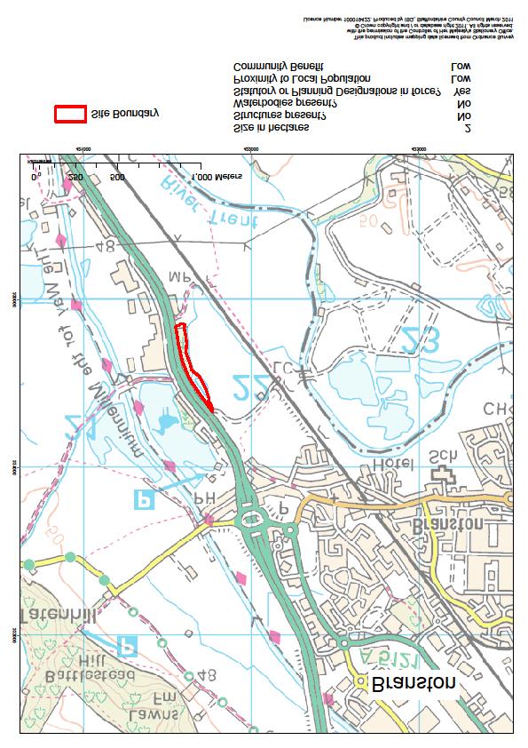
45 Branston Electoral Ward: Needwood Forest Member: Tim Corbett Parish Council: Branston Size: 2 ha Description This is a very small area of land next to the busy A38 which is not accessible to the public. Opportunities / Liabilities No opportunities for development. No works have been required or carried out for many years. 45
46 46
47 Appendix 1 Summary Details of Countryside Sites Site Name Size Facilities No of Visits p.a. (approx) Main Management Aims < 5ha 5 20ha > 20 ha Visitor centre Car parks Toilets Information Signs Catering provision Picnic area < 50, ,000 > 250,000 Informal recreation Nature conservation Agricultural production Forestry / Wood fuel Other Volunteer group on site Cannock Chase Country Park Apedale Country Park Consall Country Park Deep Hayes Country Park Greenway Bank Country Park Chasewater Country Park inc Norton Bog Froghall Picnic Area Oakamoor Picnic Area Sevens Road Picnic Area Hanbury Common Picnic Area Brownshore Lane Picnic Area Chillington Picnic Area Hanchurch Hills Picnic Area Fair Oak Picnic Area Hatherton Reservoir Stafford Newport Greenway Oakamoor Denstone Greenway Leek to Rushton Greenway Broad Lane, Essington Wimblebury Mound, Wimblebury Branston 47
Alton Towers and Caldon Canal from Stone
 UK Canal Boating UK Canal Boating Escape with a canal boating holiday! Telephone : 01395 443545 Email : bookings@ukcanalboating.com Booking Office : PO Box 57, Budleigh Salterton. Devon. EX9 7ZN. England.
Unimproved meadow with extensive riverside frontage and a bank of mixed hardwoods with good hard track access in the heart of rural South Wales.
 WOODS 4 SALE Phone: 01248 364 362 www.woods4sale.co.uk UK Woodland & Woods For Sale: Specialising in the Sales of Small Woodlands in England, Scotland and Wales for Recreation, Wildlife Conservation and
Park-specific management and policies Wainuiomata Recreation Area
 Park-specific management and policies Wainuiomata Recreation Area 6.8 Wainuiomata Recreation Area 6.8.1 Legal status Title held: Legislative status: Wellington Regional Council Administered under Local
Little Borough. Borough Farm Road Milford Surrey GU8 5JZ
 Little Borough Borough Farm Road Milford Surrey GU8 5JZ A unique opportunity to acquire an attractive and adaptable family home set in approx. 15.75 acres that includes paddocks, stables, woodland and
TOWPATH MOWING GUIDELINES
 TOWPATH MOWING GUIDELINES 24 September 2007 CONTENTS Introduction Scope and Status of Guidelines Influences on the Guidelines Health and Safety Biodiversity INTRODUCTION Towpath management is a key issue
Living & Working Access and Recreation
 Living & Working Access and Recreation 5.9 Access and Recreation Background 5.9.1 The countryside has increasingly become a popular destination for visitors and an important resource for informal recreation.
Morning Copse near Maidstone, Kent acres of Ancient Woodland with a pond, bluebells and mature oak. 26,500 (freehold)
") WOODS 4 SALE Phone: 01248 364 362 www.woods4sale.co.uk UK Woodland & Woods For Sale: Specialising in the Sales of Small Woodlands in England, Scotland and Wales for Recreation, Wildlife Conservation and
WOODS 4 SALE Phone: 01248 364 362 www.woods4sale.co.uk UK Woodland & Woods For Sale: Specialising in the Sales of Small Woodlands in England, Scotland and Wales for Recreation, Wildlife Conservation and
The Chilterns Conservation Board The Lodge Station Road Chinnor Oxon OX39 4HA
 The Chilterns Conservation Board The Lodge Station Road Chinnor Oxon OX39 4HA Tel: 01844 355500 Fax: 01844 355501 E Mail: office@chilternsaonb.org www.chilternsaonb.org PRESS RELEASE Chilterns Commons
Designated Sites. Headlines
 Designated Sites Headlines Over 36% of the Sheffield district is covered by sites with European, national or local designation. These offer valuable habitats to wildlife, with some level of protection,
Broomhill Park - 10 Year Vision Document
 Broomhill Park will provide a vibrant community focal point functioning as a green oasis within Strood, emphasizing the views of the surrounding countryside and giving consideration to biodiversity within
Appendix 7 Local Green Spaces - Detailed Evidence
 Appendix 7 Local Green Spaces - Detailed Evidence Neigh Bridge Country Park, Somerford Keynes General information Neigh Bridge Country Park is situated at the southern entrance to Somerford Keynes village.
PRIORITY HABITAT SURVEY 2017 SWALEDALE. Summary. July 2018
 PRIORITY HABITAT SURVEY 2017 SWALEDALE Summary July 2018 Conservation & Monitoring Report No: Lead Author(s): Tony Serjeant & Sue Thurley Incorporating comments from: Gary Smith & Gordon Haycock (16/07/18)
To advise members of the recent activity of the NET s, Land & Countryside Services teams for the period 1 st April to 31 st July 2016
 DATA LABEL: PUBLIC LINLITHGOW LOCAL AREA COMMITTEE SERVICE UPDATE NETS, LAND & COUNTRYSIDE REPORT BY HEAD OF OPERATIONAL SERVICES A. PURPOSE OF REPORT To advise members of the recent activity of the NET
Silver-washed Fritillaries in the Straits Inclosure in July
 ALICE HOLT FOREST Hampshire from www.discoverbutterflies.com the website for the book Discover Butterflies in Britain D E Newland Silver-washed Fritillaries in the Straits Inclosure in July Alice Holt
Reference: 06/13/0594/F Parish: Fritton & St Olaves Officer: Mrs M Pieterman Expiry Date:
 Schedule of Planning Applications Committee Date: 21 st January 2014 Reference: 06/13/0594/F Parish: Fritton & St Olaves Officer: Mrs M Pieterman Expiry Date: 20-01-2014 Applicant: Proposal: Site: Lord
Local Green Spaces Study
 Nuthurst Parish Council Neighbourhood Plan Local Green Spaces Study October 2014 Page 1 of 5 Produced by the Nuthurst Parish Neighbourhood Plan Steering Committee Local Green Spaces in Nuthurst Parish
Countryside Trails Dunkeld
 R A N G E R S E RV I C E Countryside Trails Dunkeld WELCOME Welcome to this southern end of Atholl Estates. The countryside here is a wonderful blend of lochs, woodland and heather moor. There is a large
British Horse Society-Scotland Developing Falkirk s Access Network- In the Hoof Prints of the Kelpies!
 British Horse Society-Scotland Developing Falkirk s Access Network- In the Hoof Prints of the Kelpies! Angus Duncan Outdoor Access Team Leader - Falkirk Council Facts about Falkirk Local Authority Area:
Delamere Loop. The. Useful Businesses Equestrian Escapes Tailor-made horse riding holidays in Cheshire. Tel:
 The Loop Accommodation Providers Akesmere Bed & Breakfast OS Grid Ref. SJ589/669 B&B for horse and rider. Chester Road, Little, Tarporley, Cheshire CW6 9ER Tel: 01829 760348 www.akesmerefarm.co.uk Useful
Following the Worcester & Birmingham Canal Feeder in Kings Norton Visiting Lifford Reservoir & Wychall Reservoir. Lifford
 Worcester-Birmingham & Droitwich Canals Society SUMMER WALK Following the Worcester & Birmingham Canal Feeder in Kings Norton Visiting Lifford Reservoir & Wychall Reservoir Lifford Reservoir Wychall Reservoir
Bridge School, Longmoor Campus, Coppice View Road, Sutton Coldfield, Birmingham, B73 6UE
 Committee Date: 22/01/2015 Application Number: 2014/05949/PA Accepted: 08/12/2014 Application Type: Full Planning Target Date: 02/02/2015 Ward: Sutton Vesey Bridge School, Longmoor Campus, Coppice View
IOW Ramblers Submission Paper to the Sept 2016 ROW Improvement Plan Consultation.
 IOW Ramblers Submission Paper to the Sept 2016 ROW Improvement Plan Consultation. The current Island Rights of Way Improvement Plan is a comprehensive document and much of its content is still relevant
Queen Elizabeth II Diamond Jubilee Herne Bay Coastal Park Action Plan. Kings Hill slopes, Beacon Hill, The Downs, Bishopstone Glen and Reculver
 Appendix 3 Queen Elizabeth II Diamond Jubilee Coastal Park Action Plan Kings Hill slopes, Beacon Hill, The, Bishopstone Glen and Reculver This area moves from the commercial centre of the Coastal Park
Registered Charity No
 Docklands Canal Boat Trust Registered Charity No 288345 Holidays & Day Trips on the River Boat MV. Challenge A purpose built Wide Beam River Boat providing holidays and day trips for people with disabilities,
West Wirral (Dee Estuary)
") View of Hilbre Island from West Kirby with walkers at low tide. West Wirral (Dee Estuary) West Kirby is the start of the 12 mile long Wirral Way, the backbone of Wirral Country Park, the old Hooton to
View of Hilbre Island from West Kirby with walkers at low tide. West Wirral (Dee Estuary) West Kirby is the start of the 12 mile long Wirral Way, the backbone of Wirral Country Park, the old Hooton to
Lowland Heathland in Nottinghamshire: Progress towards the LBAP
 Lowland Heathland in Nottinghamshire: Progress towards the LBAP Norma Saunders, Chief Executive Officer of The Sherwood Forest Trust Chair of Nottinghamshire Biodiversity Action Group The Seed of an idea
Aesthetic value This modernist building has medium aesthetic value and makes a neutral contribution to the character of the conservation area.
 Friends Meeting House, Harrogate 12a Queen Parade, Harrogate, HG1 5PP National Grid Reference: SE 30798 55125 Statement of Significance The meeting house is a good example of a 1960s purpose-built meeting
Three mills were situated along the Loddon Valley.
 EASTROP PARK The History of Eastrop Park Eastrop dates back to Roman times, when this lush valley would have been used to grow crops, graze cattle and water horses. It was during the Saxon times, that
Park Farm Wormshill Sittingbourne. rural land and property
 Park Farm Wormshill Sittingbourne rural land and property Equestrian Property homes for horses and riders www.hobbsparker.co.uk Park Farm Park Lane, Wormshill, Sittingbourne, Kent ME9 0UA A former arable
FAQS and Code of Conduct for use under the Tamar Trails heading on the Tamar Valley AONB and Tamar Trails websites: Tamar Trails FAQs
 FAQS and Code of Conduct for use under the Tamar Trails heading on the Tamar Valley AONB and Tamar Trails websites: Tamar Trails FAQs What are the Tamar Trails? The Tamar Trails are 25km of new and improved
YHA Green SPIRIT Plan
 YHA Green SPIRIT Plan 2011 2014 EMS 0.0.0 www.yha.org.uk Contents YHA and the Environment 03 The Green SPIRIT Plan 04 Measuring Our Impact 05 What We Already Do 07 Our Customers 09 Our People 10 Our Resources
Friends Meeting House, Leicester. 16 Queens Road, Leicester, LE2 1WP. National Grid Reference: SK Statement of Significance
 Friends Meeting House, Leicester 16 Queens Road, Leicester, LE2 1WP National Grid Reference: SK 59852 02815 Statement of Significance A meeting house purpose-built on a new site in 1955 and slightly enlarged
RED HOUSE FARM NORTH NEWBALD, BEVERLEY, EAST YORKSHIRE
 RED HOUSE FARM NORTH NEWBALD, BEVERLEY, EAST YORKSHIRE Tel: 01653 697820 CHARTERED SURVEYORS AUCTIONEERS VALUERS LAND & ESTATE AGENTS FINE ART & FURNITURE RED HOUSE FARM NORTH NEWBALD BEVERLEY, EAST YORKSHIRE
Loch Rannoch Conservation Association Strategic Development - 5 Year Action Plan
 Loch Rannoch Conservation Association Strategic Development - 5 Year Action Plan Foreword from Chair On behalf of the Loch Rannoch Conservation Association Board I am pleased to promote our 5 Year Action
Stainforth & Keadby Canal Installation of Multiuser Path
 Stainforth & Keadby Canal Installation of Multiuser Path Introduction North Lincolnshire Council has entered into an agreement with Canal & River Trust to develop proposals to introduce a multiuser path
Appendices A (Our ambition for nature (A3 plan) and further information)
 and further information)") Appendices A (Our ambition for nature (A3 plan) and further information) Penny Hill Farm Nature Conservation vision Key: Tenancy boundary Meadow restoration & Mowing/meadow F33 Mowing/meadow Progress towards
Appendices A (Our ambition for nature (A3 plan) and further information) Penny Hill Farm Nature Conservation vision Key: Tenancy boundary Meadow restoration & Mowing/meadow F33 Mowing/meadow Progress towards
SOUTH DERBYSHIRE AREA FORUM LINTON. 15 July 2015 at Coton-in-the-Elms Community Centre
 PRESENT:- SOUTH DERBYSHIRE AREA FORUM LINTON 15 July 2015 at Coton-in-the-Elms Community Centre District Council Representatives Councillor Murray (Chairman) and Councillors Atkin, Grant; Mrs Hall and
Skipton Castle Woods Accessibility Statement November 2016
 Skipton Castle Woods Accessibility Statement November 2016 Purpose: This accessibility statement outlines the available facilities and access information for Skipton Castle Woods. Welcome We, the Woodland
This page helps you find out more about Bute Park. (Including Coopers Field and Blackweir)
") This page helps you find out more about Bute Park. (Including Coopers Field and Blackweir) Bute Park Useful information is set out under the following headings: Summary Features of interest Facilities
This page helps you find out more about Bute Park. (Including Coopers Field and Blackweir) Bute Park Useful information is set out under the following headings: Summary Features of interest Facilities
Contractor VIKING Swadlincote, Bus Station BURTON UPON-TRENT, Town Hall bus stop on Waterloo
 ROUTE 1 SWADLINCOTE RODBASTON Pick up time Contractor VIKING Swadlincote, Bus Station 7.10 6.20 5.50 4.50 BURTON UPON-TRENT, Town Hall bus stop on Waterloo 7.30 6.00 5.30 4.30 Street Barton-under-Needwood,
Woodland Walk If you enjoyed this walk there are two others available in the same area.
 The Woodland Walk 11-12 kilometres (7-8 miles) 4-5 hours Terrain: some easy hills Can be slippery when wet 5 stiles Unsuitable for a pushchair/wheelchair Uses OS map 197 Parking: Pulborough Station and
Land Management Summary
 photo credit: ANGAIR Anglesea Heath Land Management Summary The Anglesea Heath (6,501 ha) was incorporated into the Great Otway National Park in January 2018. This provides an opportunity to consider the
 Local Boundary Commission for England Consultation Portal https://consultation.lgbce.org.uk/node/print/informed-representation/7655 Page 1 of 1 11/02/2016 Birmingham District Personal Details: Name: Margaret
SHEEPLEAS. Visitor Guide and Self-guided Trails
 SHEEPLEAS Visitor Guide and Self-guided Trails Sheepleas The Sheepleas is an interesting mix of woodland, scrub and open grassland, situated on the chalk of the North Downs. This diversity of habitats
COME & enjoy THE. Trans Pennine Trail. Penistone-Dunford Bridge. Trans Pennine Trail conservation volunteers Penistone Dunford Bridge
 COME & enjoy THE Penistone-Dunford conservation volunteers Penistone Dunford Welcome to your! Running between the lively market town of Penistone, and the lower slopes of the Peak District at Dunford,
Non-motorized Trail Plan & Proposal. August 8, 2014
 Town of Star Valley Ranch, Wyoming and the Star Valley Ranch Association in partnership with the USDA Forest Service, Bridger-Teton National Forest, Greys River Ranger District Non-motorized Trail Plan
Rill Farm, Colston Road, Buckfastleigh, Devon
 Rill Farm, Colston Road, Buckfastleigh, Devon Rill Farm Colston Road, Buckfastleigh, Devon, TQ11 0LW A stunning Grade II Listed farmhouse with stunning separate retreat centre. Totnes 5 ½ miles, A38 Devon
PHOENIX PARK INCORPORATING THURNSCOE COMMUNITY WOODLAND
 PHOENIX PARK INCORPORATING THURNSCOE This popular site is known for its sculptures and climbing wall which can be seen as you meander around the park. Walking towards the top of the woodland you will pass
A summary of Draft Makara Peak Mountain Bike Park Master Plan
 A summary of Draft Makara Peak Mountain Bike Park Master Plan OVEMBER 216 Image: Peter Marshall 2 3 Introduction Since it was established in 1998, the Makara Peak Mountain Bike Park (Makara Peak) has grown
AUDLEY RURAL PARISH COUNCIL ACTION PLAN 2015/16 updated as at March 16
 AUDLEY RURAL PARISH COUNCIL ACTION PLAN 2015/16 updated as at March 16 Audley Rural Parish Council constantly strives to work on behalf of parishioners on the issues that matter to the village. We are
Bedfordshire and Luton Species Action Plan: Hazel Dormouse
 Bedfordshire and Luton Species Action Plan: Hazel Dormouse Released November 2006 Last updated July 2010 Hazel dormouse, Muscardinus avellanarius Photo by Björn Schulz Bedfordshire Dormouse Group Hazel
HANBURY PARISH COUNCIL
 HANBURY PARISH COUNCIL STAFFORDSHIRE Clerk: 44 HOLLOW LANE AMANDA ANDREW DRAYCOTT IN THE CLAY 01283 820420 ASHBOURNE DERBYSHIRE hanburyparishcouncil@live.co.uk DE6 5HQ Present MINUTES OF THE PARISH MEETING
Yorkshire Dales classification of protected areas into IUCN Management Categories. Mark Fisher, November 2013 Wildland Research Institute
 Yorkshire Dales classification of protected areas into IUCN Management Categories Mark Fisher, November 2013 Wildland Research Institute Ingleborough National Nature Reserve Nesting of protected areas
ST ARVANS COMMUNITY COUNCIL
 ST ARVANS COMMUNITY COUNCIL MINUTES OF MEETING OF ST ARVANS COMMUNITY COUNCIL held at THE MEETING ROOMS, ST ARVANS on TUESDAY 9 th JULY 03 at 75 pm Present: Chairman A Vickers Councillors A Bolton B Howell
SEIGHFORD PARISH COUNCIL
 SEIGHFORD PARISH COUNCIL Minutes of the Parish Council meeting held on Monday 18 th November 2013 at Great Bridgeford Village Hall. Those present; Parish Councillors-Mrs G Cox[chair]; Mr P Eveson [deputy
Self-Catering at Magdalen Farmhouse
 Self-Catering at Magdalen Farmhouse Set in the heart of Magdalen Farm the newly renovated farmhouse has been adapted to accommodate up to 14 people. Rebuilt in the 1890 s as the main residence for the
Llandudno Junction. Regeneration Proposals for the Future. December 2009
 Llandudno Junction Regeneration Proposals for the Future December 2009 Llandudno Junction - Vision Statement 1 Purpose 1.1 The purpose of this document is to describe key priorities to support the regeneration
Hay Wood, Rowington and Baddesley Clinton - Warwickshire
 Hay Wood, Rowington and Baddesley Clinton - Warwickshire Starts at Lay-by alongside Hay Wood 2 hours 30 minutes 5.5miles 8.8km Leisurely ID: 0.683 Developed by: John Clift Checked by: Andy Page www.ramblersroutes.org
Moorland View Princetown, Devon. 4.6 acres stand of high quality, mature conifer with good access for 28,000 (freehold)
") WOODS 4 SALE Phone: 01248 364 362 www.woods4sale.co.uk UK Woodland & Woods For Sale: Specialising in the Sales of Small Woodlands in England, Scotland and Wales for Recreation, Wildlife Conservation and
WOODS 4 SALE Phone: 01248 364 362 www.woods4sale.co.uk UK Woodland & Woods For Sale: Specialising in the Sales of Small Woodlands in England, Scotland and Wales for Recreation, Wildlife Conservation and
Illawarra Escarpment State Conservation Area Walking Tracks
 Illawarra Escarpment State Conservation Area Walking Tracks NPWS Illawarra Area Office Ground Floor, Government Office Block 84 Crown Street Wollongong NSW 2500 02 4223 3000 (Mon-Fri) Royal National Park
elderstoowoomba.com.au
 4603 Oakey-Cooyar Road, NUTGROVE, QLD 4352 Grandview Excellent Homestead on 300 Acres 111.94 hectares, 276.60 acres Grandview or alternatively know as Rocky Springs is a great lifestyle grazing block that
Chandler's Wharf Retail Park Bridge Road, STOCKTON-ON-TEES, TS18 3BA
 WELL SECURED, FREEHOLD LEISURE INVESTMENT OPPORTUNITY 77% OF INCOME SECURED AGAINST MECCA BINGO LIMITED WITH 11 YEARS UNEXPIRED Chandler's Wharf Retail Park Bridge Road, STOCKTON-ON-TEES, TS18 3BA passionate
YORKSHIRE DALES NATIONAL PARK AUTHORITY ITEM 10 CHARGING FOR THE USE OF AUTHORITY OWNED PUBLIC TOILETS
 YORKSHIRE DALES NATIONAL PARK AUTHORITY ITEM 10 Date: 31 March 2015 Report: CHARGING FOR THE USE OF AUTHORITY OWNED PUBLIC TOILETS Purpose of the report 1. To seek Members approval to trial for two years,
Rudyard Lake and its Environs, Including its Place in Railway & Canal History
 Rudyard Lake and its Environs, Including its Place in Railway & Canal History RCHS West Midlands & North West Group Joint Walking Event: Thursday 26 th October 2017 The walk (a joint NW & WM Group event)
2.2 For these reasons the provision of tourist signing will only be considered:
 TOURIST SIGNING POLICY 2015 1. DEFINITION 1.1 A tourist destination is defined as a permanently established attraction which attracts or is used by visitors to an area and is open to the public without
Registered Charity No
 Holidays & Day Trips on the River Boat MV. Challenge A purpose built wide beam canal boat providing holidays and day trips for all disabled people, their carers and support organisations on the River Lee
How to apply for tourism signs
 How to apply for tourism signs Kent County Council Highways and Transportation (KCC Highways) control signs on local roads (excluding Medway) and sets out local policy on brown signs for tourist destinations.
The Rill Estate, Colston Road, Buckfastleigh, Devon
 The Rill Estate, Colston Road, Buckfastleigh, Devon The Rill Estate Colston Road, Buckfastleigh, Devon, TQ11 0LW An opportunity to purchase a thriving retreat centre, with separate family accommodation,
Interpreting the Lagan Valley Regional Park. The Lagan Navigation: The unfolding story of a proud heritage Dr Andy Bridge
 Interpreting the Lagan Valley Regional Park The Lagan Navigation: The unfolding story of a proud heritage Dr Andy Bridge A bit about us Designated an AONB under the Amenity Lands Act (NI) 1965 The Regional
Rodington Parish Council. Council Meeting
 Rodington Parish Council Council Meeting Minutes of Rodington Parish Council meeting held on Wednesday 4 January 2011 at Longdon upon Tern Village Hall. Present: Councillors B Ashton, M Crump, J French,
BASCHURCH PARISH COUNCIL CHAIRMAN S ANNUAL REPORT 2017
 BASCHURCH PARISH COUNCIL CHAIRMAN S ANNUAL REPORT 2017 The Parish Council is keen to keep you informed about its activities over the last year. Here is a summary of our main achievements and difficulties
RATTLESNAKE HILL PHILLIPS, HARRIS FARM, LIME KILN & QUARRY
 Town of, MA Trails Map 6a SPLIT ROCK PRIMARY SECONDARY PRIVATE PRIVATE PROPERY STAY ON HEAD FUTURE TO SKINNER (NOT MARKED) 0 miles 0.25 0.250 0.5 Mapbox, Data Odbl, OpenStreetMap contributors primary use
SAINT OSWALD S CHURCH. In the Parish of Hinstock
 SAINT OSWALD S CHURCH ( The stone Church with the warm heart ) In the Parish of Hinstock Introduction A road ran through Hinstock as long ago as Roman times when the springs which currently fill the Bearcroft
BELLHOUSE PROVINCIAL PARK
 BELLHOUSE PROVINCIAL PARK PURPOSE STATEMENT AND ZONING PLAN March 2003 1 BELLHOUSE PROVINCIAL PARK Purpose Statement and Zoning Plan Primary Role The primary role of Bellhouse Provincial Park is to protect
FOR SALE Land at Mill Lane, Taplow, Buckinghamshire, SL6
 FOR SALE Land at Mill Lane, Taplow, Buckinghamshire, SL6 On the instructions of Malcolm Cohen and Shay Bannon of BDO LLP, Joint Administrators of Watchword Limited In Administration ( the Company ). The
On the right track Esk to Toogoolawah 19 km
 www.brisbanevalleyrailtrail.org.au On the right track Esk to Toogoolawah 19 km rail summar Location Trail summary The Brisbane Valley Rail Trail, when completed, will be a 148 kilometre recreation trail
Councillor Briefing on Elvetham Chase
 Councillor Briefing on Elvetham Chase In partnership with the Calthorpe Estate, Wates Developments vision for Elvetham Chase is to provide an outstanding new community for Hart District that will become
WINTERTON TOWN COUNCIL 52 West Street, Winterton, Scunthorpe, North Lincolnshire. DN15 9QF Phone: or
 WINTERTON TOWN COUNCIL 52 West Street, Winterton, Scunthorpe, North Lincolnshire. DN15 9QF Phone: 01724 488085 or email clerk@wintertoncouncil.co.uk Minutes of the Meeting of Winterton Town Council held
Coast Path Survey Stretch 09 Shalfleet Mill to Thorness Bay
 Coast Path Survey Stretch 09 Shalfleet Mill to Thorness Bay Overview Map of stretch Introduction This stretch of Island coast covers several salt marsh creeks backed by grazing land and woodland on the
8 KINNEDDAR MAINS STEADING, SALINE, FIFE, KY12 9LJ
 8 KINNEDDAR MAINS STEADING, SALINE, FIFE, KY12 9LJ 8 Kinneddar Mains Steading, Saline, Fife, KY12 9LJ Unique Family home in an award-winning development, with lovely countryside views Dunfermline 7m, Kinross
TODLAW FARM LESMAHAGOW
 TODLAW FARM LESMAHAGOW TODLAW FARM, LESMAHAGOW EXTENDING TO 204 ACRES FOR SALE BY PRIVATE BARGAIN Seller: Mrs Wilson Todlaw Farm Lesmahagow ML11 0HN Solicitors: Miller Beckett & Jackson 190 St Vincent
LONG LET HEADQUARTERS OFFICE INVESTMENT KING EDWARDS COURT KING EDWARDS SQUARE SUTTON COLDFIELD BIRMINGHAM B73 6AY
 LONG LET HEADQUARTERS OFFICE INVESTMENT KING EDWARDS COURT KING EDWARDS SQUARE B73 6AY INVESTMENT SUMMARY Sutton Coldfield is an affluent commercial centre within Birmingham and the West Midlands conurbation,
Special nature reserve and ornithological reserve Scope of implementation (local, Local national)
") Example of good practice From a waste disposal area to a protected area: the example of the Tivat salt flats Category Management; education; tourism Organization Centre for bird protection and monitoring
Example of good practice From a waste disposal area to a protected area: the example of the Tivat salt flats Category Management; education; tourism Organization Centre for bird protection and monitoring
Supporting information to an application for preapplication 3 rd February 2017
 Development Services, West Lindsey District Council, Guildhall, Marshall s Yard, Gainsborough DN21 2NA Supporting information to an application for preapplication advice. 3 rd February 2017 Proposal for
Mersey Valley Timberland Trail
 Route Pack Page 1 Route Summary A long distance linear walk on roads and country paths linking town and countryside to parks, woodlands and other open spaces. Grade Distance Accessibility Allow Start Map
Friends Meeting House, Hitchin. 1 Paynes Park, Hitchin, Hertfordshire, SG5 1EH. National Grid Reference: TL Statement of Significance
 Friends Meeting House, Hitchin 1 Paynes Park, Hitchin, Hertfordshire, SG5 1EH National Grid Reference: TL 18282 29279 Statement of Significance A meeting house of 1957 designed by Paul V. Mauger and erected
Aira Force & Ullswater Access Statement
 Aira Force & Ullswater Access Statement Aira Force, Watermillock, Penrith, CA11 0JS T: 017684 82067 E: ullswater@nationaltrust.org.uk Section 1: Aira Force Section 2: Ullswater Countryside Section 1: Aira
PORTISHEAD BRANCH LINE PRELIMINARY ENVIRONMENTAL INFORMATION REPORT VOLUME 4 APPENDIX Water Receptors
 PORTISHEAD BRANCH LINE PRELIMINARY ENVIRONMENTAL INFORMATION REPORT APPENDIX 17. 3 Water Receptors Contents Section Page 1 Water Receptors... 1-1 1.1 Surface Water Features/Receptors in the Study Area
Preferred Recreation Recommendations Stemilt-Squilchuck Recreation Plan March 2018
 Preferred Recreation Recommendations Stemilt-Squilchuck Recreation Plan March 2018 Below are the recommended recreation ideas and strategies that package together the various recreation concepts compiled
PUBLIC CONSULTATION - THE PURPOSE
 PUBLIC CONSULTATION - THE PURPOSE ² To review the sites identified for housing development; ² To introduce new sites that have come forward since the last Public Consultation with potential for housing
Farley Green Surrey Hills Guide 799,950 Freehold. Holmbury St Mary, Surrey, 1,175,000 F/H
 Farley Green Surrey Hills Guide 799,950 Freehold Holmbury St Mary, Surrey, 1,175,000 F/H A rarely available detached character converted stable block situated in the much sought after hamlet of Farley
UPPER POPPLETON PARISH COUNCIL
 UPPER POPPLETON PARISH COUNCIL MINUTES OF THE PARISH COUNCIL MEETING HELD IN THE POPPLETON CENTRE, MAIN STREET, UPPER POPPLETON AT 7.00 PM ON MONDAY 8 OCTOBER 2018 PRESENT Councillor Stuart Robson (Chairman)
Yard Creek Provincial Park. Management Plan
 Yard Creek Provincial Park Management Plan Draft January 2010 Yard Creek Provincial Park Management Plan Approved by: telàlsemkin/siyam/chief Scott Benton Bill Williams Squamish Executive Director ation
Westbury House, Westbury Sub Mendip, Somerset. BA5 1HA 1,400,000
 Westbury House, Westbury Sub Mendip, Somerset. BA5 1HA 1,400,000 Period village property set within extensive formal gardens, extending over 3 acres, Southerly views over open countryside towards Westbury
COWES TOWN COUNCIL Minutes of the Projects Committee held in the Town Council Office, Northwood House, Cowes on Tuesday, 18 October 2016 at 6.
 COWES TOWN COUNCIL Minutes of the Projects Committee held in the Town Council Office, Northwood House, Cowes on Tuesday, 18 October 2016 at 6.15pm Present: Councillors Nicholson (Chair), Banks, Bartrum,
Address Town City Telephone. 240 Uttoxeter Road Blythe Bridge Staffordshire Hanbridge. Newcastle-under-
 Name Blythe Bridge Bradwell North Staffordshire Address Town City Telephone 240 Uttoxeter Blythe Bridge Staffordshire 01782 393127 111 Hanbridge Avenue Bradwell Lyme 01782 711493 Butt Lane 147 Congleton
Binley Woods Parish Plan - Analysis of Main Survey Responses Section D1 Sports Activities & Play Equipment
 Binley Woods Parish Plan - Analysis of Main Survey Responses Section D1 Sports Activities & Play Equipment Question D1: How often do you use the following? Binley Woods Parish Plan Main Questionnaire 1
SWALLOWS NEST, TILLAND, TIDEFORD, SALTASH, CORNWALL PL12 5JE OFFERS IN EXCESS OF 600,000
 SWALLOWS NEST, TILLAND, TIDEFORD, SALTASH, CORNWALL PL12 5JE OFFERS IN EXCESS OF 600,000 SALTASH 7 MILES, PLYMOUTH 12 MILES, WHITSAND BAY 8 MILES An immensely pretty detached and south facing country residence
FOR SALE, ESTABLISHED, WELL APPOINTED HOTEL AND EVENTS VENUE THE CHICHESTER HOTEL OLD LONDON ROAD, WICKFORD, ESSEX SS11 8UE
 FOR SALE, ESTABLISHED, WELL APPOINTED HOTEL AND EVENTS VENUE THE CHICHESTER HOTEL OLD LONDON ROAD, WICKFORD, ESSEX SS11 8UE Offers Invited for the leasehold interest in the property and business SUMMARY
LANDKEY PARISH COUNCIL. Minutes of the Parish Council meeting held in the Old School Centre on Wednesday 7 th February 2018 at 7.30 p.m.
 LANDKEY PARISH COUNCIL Minutes of the Parish Council meeting held in the Old School Centre on Wednesday 7 th February 2018 at 7.30 p.m. Present: - Chairman Councillor Prowse Councillors Beer, Halliday,