COASTAL CONSERVANCY. Staff Recommendation October 21, 2010 PETALUMA TRESTLE REHABILITATION DESIGN
|
|
|
- Myron Rice
- 6 years ago
- Views:
Transcription
1 COASTAL CONSERVANCY Staff Recommendation October 21, 2010 PETALUMA TRESTLE REHABILITATION DESIGN Project No.: Project Manager: Deborah Hirst RECOMMENDED ACTION: Authorization to disburse up to $475,000 to the City of Petaluma to complete analysis, engineered designs and permits for the rehabilitation of the historic trestle on the Petaluma River for public access in downtown Petaluma, Sonoma County. LOCATION: Located on bank of the Petaluma River in downtown Petaluma (see Exhibit 1) PROGRAM CATEGORY: San Francisco Bay Area Conservancy EXHIBITS Exhibit 1: Project Location Maps Exhibit 2: Trestle Photographs Exhibit 3: Trestle Rehabilitation Map Exhibit 4: Project Letters RESOLUTION AND FINDINGS: Staff recommends that the State Coastal Conservancy adopt the following resolution pursuant to Sections of the Public Resources Code: The State Coastal Conservancy hereby authorizes disbursement to the City of Petaluma of an amount not to exceed four hundred seventy-five thousand dollars ($475,000) to complete analysis, engineered designs and permits for the rehabilitation of the historic trestle on the Petaluma River for public access in downtown Petaluma, Sonoma County. Prior to the disbursement of any Conservancy funds, the City shall submit for review and approval of the Executive Officer of the Conservancy a work program, schedule and budget, and the names and qualifications of any subcontractors that it intends to employ for this planning work. Staff further recommends that the Conservancy adopt the following findings: Based on the accompanying staff report and attached exhibits, the State Coastal Conservancy hereby finds that: 1. The proposed project is consistent with the current Project Selection Criteria and Guidelines. Page 1 of 7
2 PETALUMA TRESTLE RESTORATION DESIGN 2. The proposed authorization is consistent with the purposes and objectives of Chapter 4.5 of Division 21 of the Public Resources Code, regarding the resource and recreational goals of the San Francisco Bay Area, including the improvement of public access through regional and local trails connecting population centers and public facilities. PROJECT SUMMARY: Staff recommends that the State Coastal Conservancy authorize disbursement of up to $475,000 to the City of Petaluma to complete analysis, engineered designs and permits for the rehabilitation of the historic trestle on the Petaluma River for public access in downtown Petaluma, Sonoma County. The proposed project will enable the City of Petaluma to complete the necessary analysis of geotechnical and structural conditions to design an effective rehabilitation of the Petaluma trestle and stabilization of the riverbank beneath. The project will include analysis of and design plans for: the trestle structure, improvement of the trestle deck, bank stabilization as identified through the analysis, replacement of the railroad tracks, interpretive panels for both the riverfront history and the storm water runoff cycle readily observed at the project site, completion of the Petaluma River Trail for safe passage of bicyclists and pedestrians; and environmental review of the proposed designs to assess any potential impacts and provide appropriate mitigation measures where necessary. The restoration design will incorporate recreational, environmental, educational and accessibility elements for public access along the approximately 500-foot long historic railroad trestle. The Petaluma General Plan (2008), The Central Petaluma Specific Plan (2003) and The River Access and Enhancement Plan (1996) emphasize the importance of reorienting the Petaluma community toward the River and enhancing this green ribbon with improved public access, recreation, education and river restoration. Transportation and commerce along the river have been defining aspects of the character and identity of downtown Petaluma, and the proposed trestle restoration project offers a means of preserving the highly visible trestle boardwalk element of the urban waterfront in Petaluma. There is urgency for the proposed project as the trestle has been fenced off from public pedestrian and bicycle access for a number of years due to deterioration of the wooden structure and supports while awaiting a path forward for restoration (see Exhibits 2 and 3). The Sonoma-Marin Area Rail Transit District (SMART) owns the Petaluma trestle and is working in partnership with the City to address the risk the trestle now poses to public access. Development and operation of a 14 station passenger rail system and network of bike and pedestrian paths along the Highway 101 corridor between the ferry terminal in Larkspur in Marin County (Marin) and Cloverdale in Sonoma County (Sonoma) is the primary purpose of the quarter cent sales tax for SMART approved by Marin and Sonoma voters in November By 2014, SMART will complete and put into operation a system with 70 miles of rail service, as well as 54 miles of multi-use path and 17 miles of Class II bike lane in Sonoma and Marin as an alternative to driving; the $590 million project is largely being funded by voter-approved sales tax revenue. The system will serve 5 stations in Marin and 9 stations in Sonoma, including the Petaluma station located within walking distance from Petaluma s planned transit hub and the historic railroad trestle on the Petaluma River Trail. SMART s existing rail corridor through Petaluma offers sufficient space to enable a future rail with trail design for multi-use public Page 2 of 7
3 PETALUMA TRESTLE RESTORATION DESIGN access. Bicycle and pedestrian paths are a fundamental aspect of the SMART system for providing alternate transportation from highway driving. SMART staff is working with the City to identify other funding sources available to SMART to contribute to the restoration of the SMART-owned trestle on the river. The City of Petaluma s Bicycle and Pedestrian Plan (2008) identifies the Petaluma River Trail and the SMART corridor rail-to-trail project as two of the five highest priority projects for bicycle and pedestrian access for the city. The trestle is considered an important segment of the Petaluma River Trail which begins on the eastern side of Petaluma at Prince Park and travels west into downtown Petaluma to the trestle area. Future extension of the Petaluma River Trail from the trestle south along the river has potential to connect additional parks and trails in Petaluma. Three significant regional trails being developed with support from the Conservancy have potential to link to the trestle project s improvements. A proposed realignment for a segment of the Bay Area Ridge Trail would move the Petaluma section of the 580-mile trail off of local roads and onto an alignment along Adobe Creek and Northwest Pacific railroad right-of-way to Steamer Landing Park on the Petaluma River. A recent request by the City to the Association of Bay Area Governments proposes an extension of the current proposed alignment of the 500-mile San Francisco Bay Trail to include a connector trail into downtown Petaluma to the Turning Basin. Petaluma would serve as a junction for these regional trails along the Petaluma River, an existing bridge and the local Petaluma River Trail over the restored trestle downtown. In addition, the San Francisco Bay Area Water Trail has a pullout site at the Turning Basin across from the trestle and a recently improved floating dock with boat tie-up spaces has direct access from the river up to the public access downtown at the proposed project location. Potential also exists to restore a historic trolley line through the main commercial area of Petaluma s historic waterfront area to connect with the regional rail corridor being planned for Sonoma and Marin. The restoration of the trestle is a component necessary to attract support for the viability of a restored trolley service over the railway along the Petaluma River. The City has applied for Caltrans funds to pursue a feasibility study for restoration of the historic trolley line and will pursue this longer term, transit-specific project in addition to the public access and trails focus of the proposed project. The City s proposed trestle rehabilitation project with Conservancy funds will evaluate the difference in cost between a trestle with rail option and a trestle without rail option and explore the possibility that the public use design requirements and the trolley rail design requirements may be close in cost for construction. The Conservancy s funding for the proposed project provides an opportunity to design the trestle rehabilitation to meet the requirements for both public access and the restoration of the historic trolley line in Petaluma. The City of Petaluma, SMART, Petaluma Trolley (a 501 (c)(3) organization), and other project partners anticipate seeking multiple sources of implementation funding to complete the trestle restoration project. Among the sources being explored are possible contributions from the Petaluma City Redevelopment Agency, SMART, the State Water Resources Control Board, public agency grants for transportation and smart growth, and foundation grants. Congestion Management Agency funds administered by Sonoma County Transit Agency through a joint power authority may also be a possible source as Sonoma County Regional Parks is applying for these funds to complete 1.3 miles of SMART trail in the City of Santa Rosa with Santa Rosa Redevelopment District funds as match. Page 3 of 7
4 PETALUMA TRESTLE RESTORATION DESIGN Site Description: The proposed project is located in Sonoma County on the Petaluma River in Petaluma s historic downtown commercial district, which is listed on the National Register of Historic Places. Since the 1850 s, the defining features of the City of Petaluma have included the namesake river that runs through downtown, the Victorian-era shopping district and the area s distinctive waterfront industry warehouses. The Petaluma River begins 4 miles north of town, flows through the City and joins San Pablo Bay 14 miles to the south. This navigable waterway is tidally influenced with river level fluctuating up to nine feet. The railroad trestle constructed of redwood in 1922 was the main transit point between the river and commerce on land. The 500-foot trestle is elevated above the river between the Water Street Plaza completed in 2006 and the Petaluma Yacht Club on First Street. Across the river lies the historic Turning Basin where boats would turn on the river to travel back south to San Francisco Bay. Today, trade on the river continues with 800 to 1 million tons of cargo moving into and out of Petaluma by commercial boat each year. In addition, an estimated 500 recreational watercraft annually make Petaluma a destination. The City has approximately 58,000 residents and is within an hour s drive for much of the San Francisco Bay Area. Project History: The Conservancy provided support for the City of Petaluma s development of The Petaluma River Access and Enhancement Plan (1996), which includes specific recommendations to restore the trestle and complete the Petaluma River Trail as part of the reorientation of the community toward the river. A structural evaluation of the trestle and a historical structure report were completed by the City in November This study concluded the trestle abutments, piles, support structure and wood decking are not currently capable of supporting pedestrian or trolley loads and identified rehabilitation approaches and cost estimates in the range of $2 million to $2.8 million. The study did not include a geotechnical component to evaluate the possible need for bank stabilization; this will be conducted as a component of the proposed project. The City began discussion with Conservancy staff in 2007 and developed the current project with input from project partners in the Summer of In spite of challenges posed by the State economy and the economic conditions for the City and SMART, the partners have identified staff time that will be contributed to the proposed project and the identification of implementation funding. Petaluma Trolley is a Historical Railroad Museum organization that has worked with the City over a number of years to support the restoration of the trestle and the historic trolley line. Over the six-year process of developing the River Access and Enhancement Plan, members of the community and a large range of supporters including elected officials have come to see the trestle and trolley as important features for public access and the economic center of Petaluma. Recent attendance at the Petaluma River Revival Festival demonstrated the desire for individuals and families to access waterfront recreation with a historical theme. Until the closure of the trestle, annual River Festivals were held on and around the trestle with thousands of participants (See Exhibit 2 for photographs). Specific improvements for trail, environmental education and open space made possible in part with Conservancy funding in the Petaluma area include The Petaluma River Access and Enhancement Plan, the McNear Peninsula Ridge Trail Link, Petaluma Marsh Trails, the Lynch Creek Trail and educational displays at the Point Reyes Bird Observatory San Francisco Bay Research Center. The Conservancy has also supported the preparation of the environmental document for the Countywide Bicycle and Pedestrian Plan, working with Sonoma County Page 4 of 7
5 PETALUMA TRESTLE RESTORATION DESIGN Regional Parks. This programmatic environmental document will benefit regional trails and bicycle improvements in Petaluma and the region as a whole. The City of Petaluma has given a high priority to this extremely visible and pressing urban waterfront access restoration project and is ready to immediately begin the proposed project should it be approved. PROJECT FINANCING Coastal Conservancy $475,000 City of Petaluma $15,000 Sonoma-Marin Area Rail Transit $10,000 Total Project Cost $500,000 The anticipated source of Conservancy funds is the fiscal year 2008/09 appropriation to the Conservancy from the Safe Drinking Water, Water Quality and Supply, Flood Control, River and Coastal Protection Bond Act of 2006 (Proposition 84). These funds are available for all the purposes of the San Francisco Bay Area Conservancy Program and are appropriate for the funding planning for the restoration of the Petaluma trestle for public access on the Petaluma River Trail. The City anticipates matching Conservancy funds in-kind by 5% with support from SMART. CONSISTENCY WITH CONSERVANCY S ENABLING LEGISLATION: Pursuant to Section 31162(a) of the Public Resources Code, the Conservancy may award grants in the nine-county San Francisco Bay Area that will help to improve public access to, within, and around urban open spaces, consistent with the rights of private property owners, and without having a significant adverse impact on agricultural operations and environmentally sensitive areas and wildlife. Consistent with Section 31162(a), the proposed project will enable a local government to plan for the rehabilitation of a public access along a historic downtown railroad trestle on Petaluma River. In addition, the proposed project will be designed to not have a significant impact on environmentally sensitive areas or wildlife, which will be confirmed through California Environmental Quality Act review pursuant to this authorization. Consistent with Section 31163(a), the Conservancy cooperates with cities, counties and districts in identifying and adopting long-term resource and outdoor recreational goals for the San Francisco Bay Area. Completion of the Petaluma River Trail and restoration of the Petaluma trestle are identified in (1) The City of Petaluma: General Plan 2025 (2008), (2) The City of Petaluma Bicycle and Pedestrian Plan (2008), (3) The Central Petaluma Specific Plan (2003), and (4) The Petaluma River Access and Enhancement Plan (1996). Finally, the proposed project is appropriate for prioritization under the selection criteria set forth in Section 31163(c) for the following reasons: (1) The project is supported by adopted local plans including The City of Petaluma: General Plan 2025 and The Petaluma River Access and Enhancement Plan. (2) The project serves a regional constituency by contributing toward the completion of a riverfront trail with proposed connections to multiple regional trail systems in the San Francisco Bay Area. Page 5 of 7
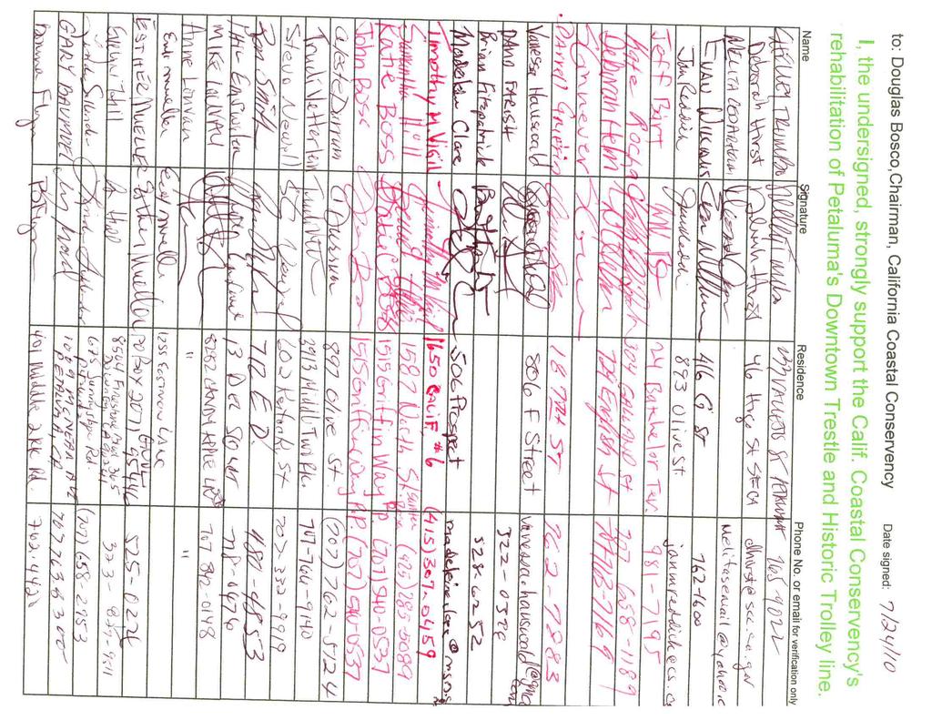
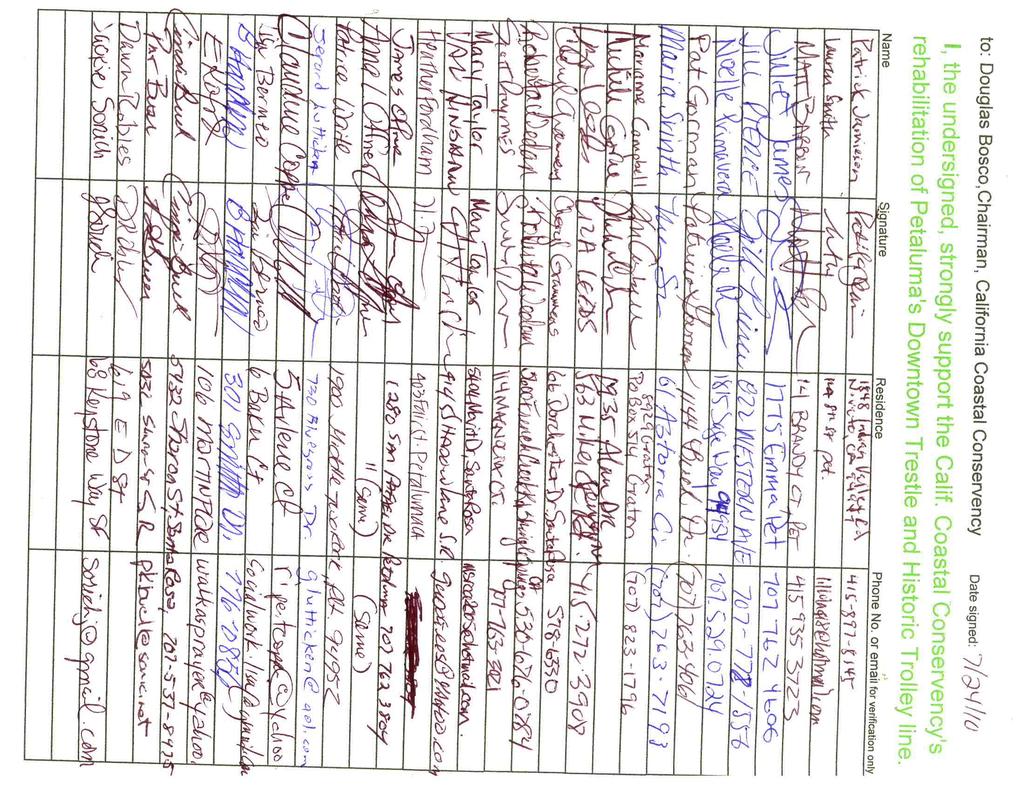
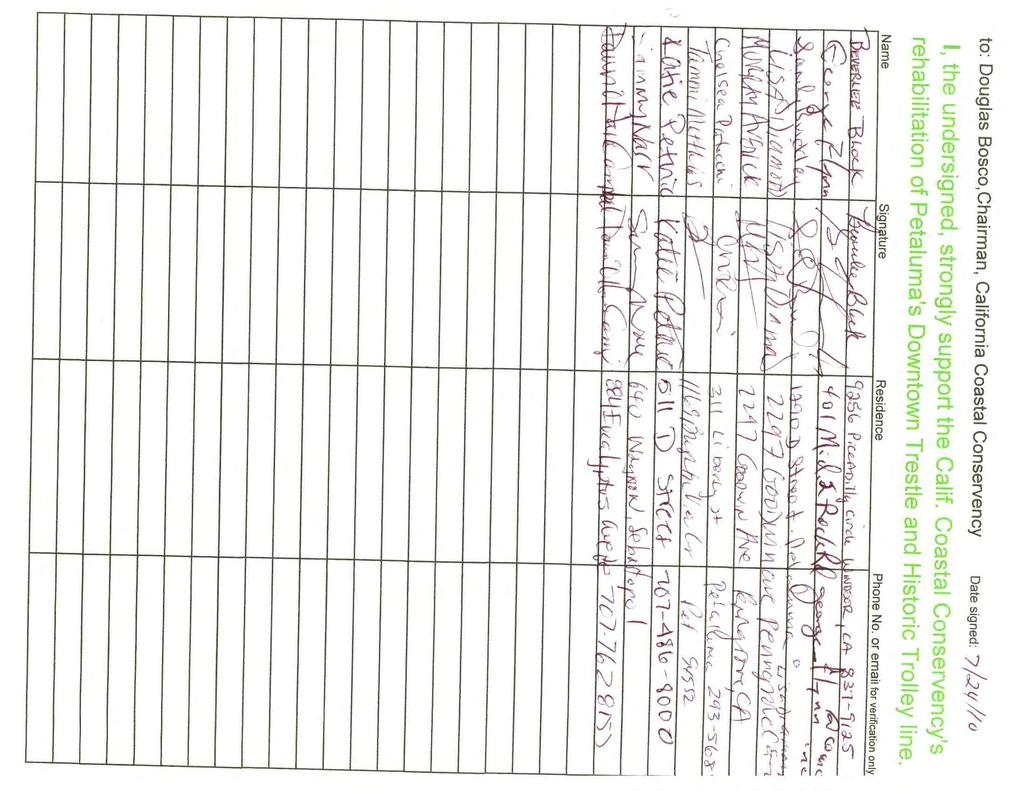
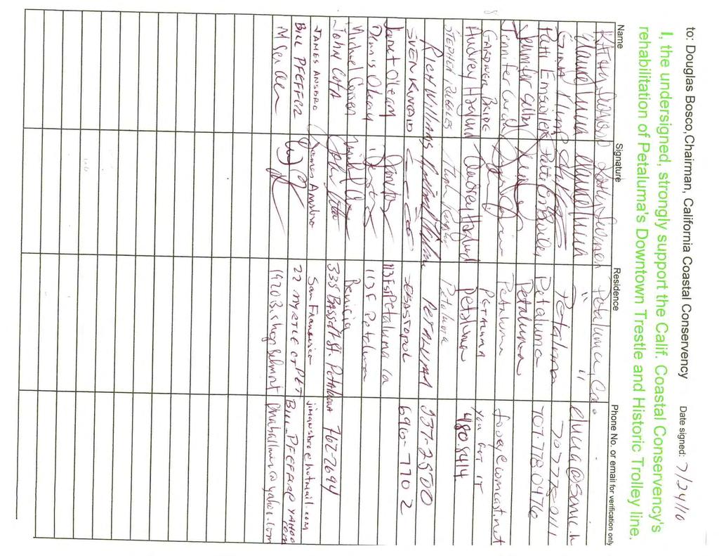
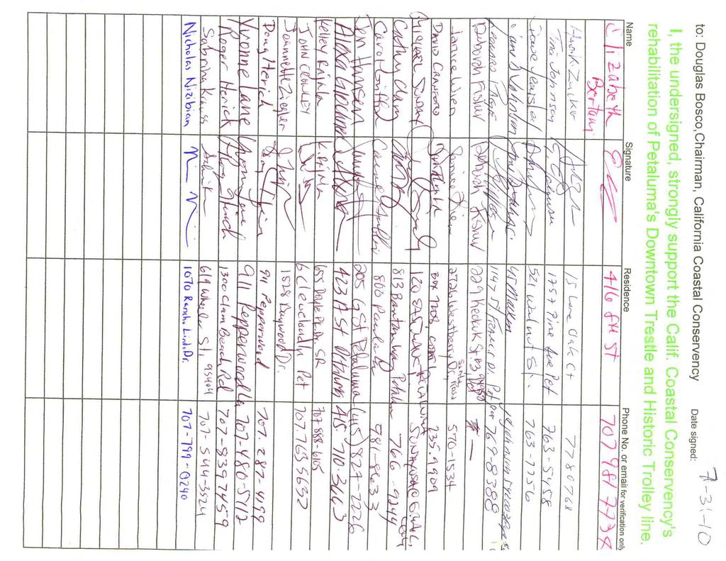
6 PETALUMA TRESTLE RESTORATION DESIGN (3) The project can be implemented in a timely manner, as the authorization supports a high priority project identified by the City. (4) The project provides benefits that could be lost if the project is not quickly implemented as the blocked public access on the river will continue and the trestle will further deteriorate if the momentum to restore access over the trestle is not acted upon. (5) The proposed project leverages matching funds from both the City of Petaluma and SMART. CONSISTENCY WITH CONSERVANCY S 2007 STRATEGIC PLAN GOAL(S) & OBJECTIVE(S): Consistent with Goal 11, Objective A of the Conservancy s 2007 Strategic Plan, the proposed project will plan a project that provides for recreational facilities. Consistent with Goal 11, Objective H of the Conservancy s 2007 Strategic Plan, the proposed project will provide a plan for a link in a regional trail. CONSISTENCY WITH CONSERVANCY S PROJECT SELECTION CRITERIA & GUIDELINES: The proposed project is consistent with the Conservancy s Project Selection Criteria and Guidelines, last updated on June 4, 2009, in the following respects: Required Criteria 1. Promotion of the Conservancy s statutory programs and purposes: See the Consistency with Conservancy s Enabling Legislation section above. 2. Consistency with purposes of the funding source: See the Project Financing section above. 3. Support of the public: The proposed project has strong support from elected officials including Congresswoman Woolsey, State Senator Wiggins, State Senator Leno, Assemblyman Huffman and the Petaluma City Council as well as the public. See project letters and the Petaluma Trolley petition in Exhibit Location: The Petaluma trestle is located on the western bank of the Petaluma River across from the historic turning basin within the City of Petaluma. Approximately 500 feet long, the trestle begins at the Yacht Club at 1 st Street and runs to Western Avenue where it ends at the recently renovated Water Street Plaza. 5. Need: The City of Petaluma and SMART must address the failing trestle and find a resolution to restore public access along the Petaluma River in the highly scenic business district downtown. Without Conservancy support for the proposed project the City risks potential loss of the historic trestle structure for waterfront public access. 6. Greater-than-local interest: The trestle and historic downtown of Petaluma are draws for tourists, visitors and sailors from the Bay Area and beyond due, in part, to the public access along the Petaluma riverfront and the Petaluma River Trail. The San Francisco Bay Area Water Trail, the San Francisco Bay Trail and the Bay Area Ridge Trail are regional trails with potential connections to the trestle on the Petaluma River Trail. Page 6 of 7
7 PETALUMA TRESTLE RESTORATION DESIGN 7. Sea level rise vulnerability: The Petaluma River has an upper bank of more than 15 feet in the area of the trestle in downtown Petaluma, fourteen miles up river from San Pablo Bay; current tidal influence results in a fluctuation of water surface height between extreme low and high tides by approximately 9 feet. Future actions designed and permitted through the proposed project will not be vulnerable to projected sea level rise of 16 inches by year 2050 or 55 inches by year Additional Criteria 8. Urgency: The proposed project will address the currently unsafe, fenced-off public space along the Petaluma River where the existing historic trestle has become dilapidated. Without the proposed project, the trestle structure will continue to deteriorate and risk failure. 9. Leverage: See the Project Financing section above. 10. Readiness: The City of Petaluma is ready to complete the proposed project, and has identified both City staff time and a commitment for SMART staff time to support the project. 11. Realization of prior Conservancy goals: See Project History above. 12. Return to Conservancy: See the Project Financing section above. 13. Cooperation: The City of Petaluma and the Sonoma-Marin Area Rail Transit District are working in partnership to develop specific rail and trail related infrastructure for Petaluma, including the proposed trestle design project. The project also enjoys the participation and cooperation of other organizations including Petaluma Trolley. COMPLIANCE WITH CEQA: California Code of Regulations title 14, section states that a project involving only feasibility or planning studies for possible future actions that have not yet been approved does not require the preparation of an Environmental Impact Report ( EIR ) or Negative Declaration under the California Environmental Quality Act but does require the consideration of environmental factors. The proposed project consists of planning and design work, including the preparation of engineered plans, permit applications and environmental review documents for possible future action that has not yet been funded by the Conservancy (or approved by any other public entity). Accordingly, the proposed project does not require preparation of an EIR or negative declaration. There are no actions associated with the proposed project that raise environmental considerations. Upon approval, staff will file a Notice of Exemption for the project. Page 7 of 7

8 Project Location: City of Petaluma Exhibit 1: Project Location Map


9 Exhibit 2: Trestle Photographs The Petaluma trestle today - in contrast with the actively used pedestrian bridge over the river. The Petaluma River Festivals held on the trestle between 1986 and 1997 drew over two hundred thousand visitors to downtown Petaluma - before the trestle was closed to public access.


10 Exhibit 2: Trestle Photographs An artist s computer enhanced vision of the restored trestle on the Petaluma River. Petaluma Trolley is working to inspire the restoration of the trestle and historic trolley service in downtown Petaluma (Photo taken at the highly attended 2010 Petaluma River Revival Festival).


11 Exhibit 2: Trestle Photographs A future envisioned with both the historic trolley and trestle in operation on the Petaluma River. The proposed 3 mile Petaluma Trolley Route would utilize the restored Petaluma trestle.


12 Exhibit 2: Trestle Photographs The Petaluma floating dock, located adjacent to the trestle, is actively used by the public.

13 Exhibit 3: Trestle Rehabilitation Map
14
15
16
17

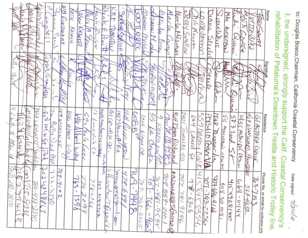
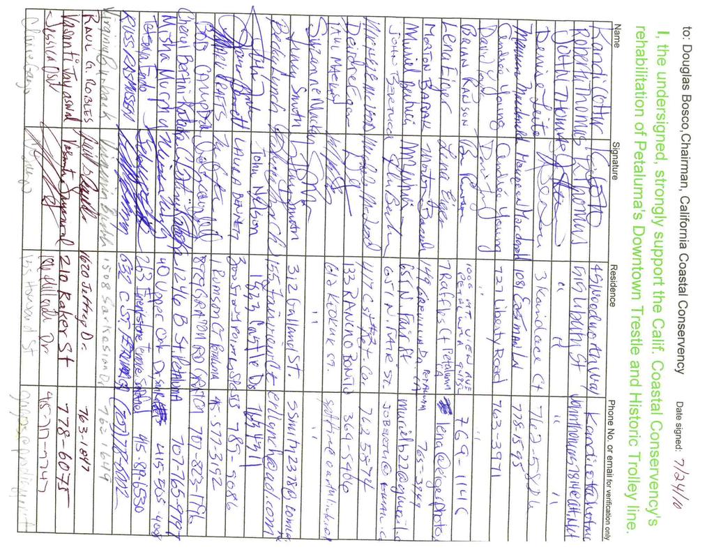
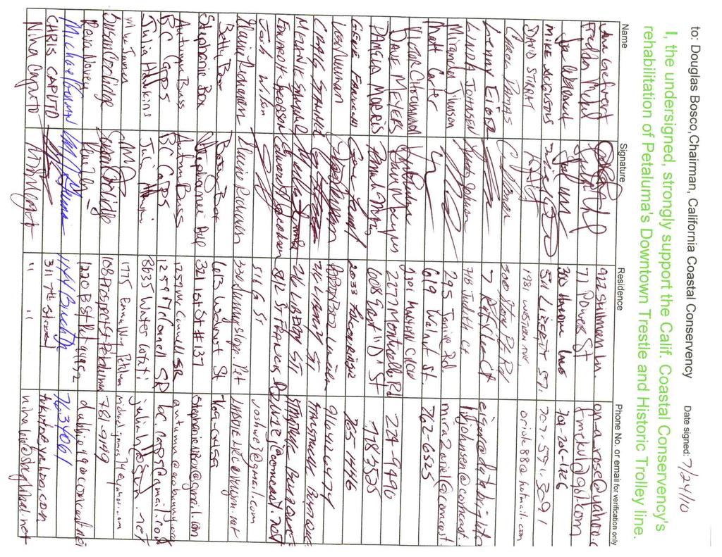
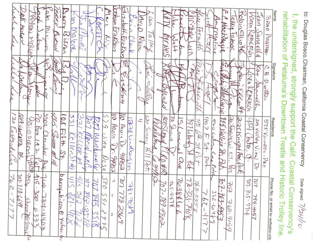
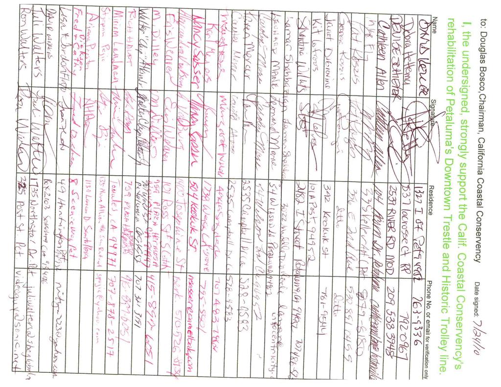
18 Mr. Douglas Bosco Chairman California Coastal Conservancy 1330 Broadway, 13 th floor Oakland, Ca August 4, 2010 Dear Mr. Bosco and members of the Coastal Conservancy; I am writing in support of the grant application by the City of Petaluma for funds to restore the historic railroad trestle in downtown Petaluma, adjacent to the Petaluma River turning basin. As a leading advocate for River access, appreciation and conservation Friends of the Petaluma River is aware of the key role the trestle played in connecting people to the River in the past and looks forward to it resuming that role in the future. The Railroad trestle is a community asset that is most worthy of restoration, as it played a key role in the commercial and cultural fabric of Petaluma for decades. Unfortunately, like many unused historic assets it has fallen into disrepair. To lose it would be to lose an important piece of the River s and the region s cultural heritage. Petaluma is where San Francisco Bay maritime traffic connected with North Coast Railroad traffic to move raw materials, manufactured goods, and people throughout Northern California before the arrival of bridges. This is an important story that we plan to tell in the River Heritage Center (RHC) that Friends is creating in nearby Steamer Landing Park (map attached). In fact, in partnership with Friends, the City of Petaluma has recently submitted a grant application to Ca. State Parks to help fund that center. Part of the RHC plan is to connect downtown Petaluma to the proposed S. F. Bay Water Trail and existing S. F. Bay hiking trail by providing riverfront docks, camping amenities, and nature education facilities just down the River from the turning basin. The California Coastal Conservancy has already invested generously in the natural and cultural resources of Petaluma by providing funding to help purchase property and build trails at our new Ellis Creek Water Recycling Facility, Tolay Lake Regional Park, and the San Francisco Bay Trail; for which we are most grateful. Funding to restore the railroad trestle in downtown Petaluma would help to connect this wonderful string of jewels to the North Bay s historic confluence of maritime and rail commerce, adding to your legacy of providing valuable regional assets for future generations to enjoy. Sincerely; David Yearsley Executive Director
19
20 May 17, 2010 Ms. Diane Ramirez City of Petaluma Department of Public Works 11 English Street Petaluma, CA Subject: SF Bay Trail Support for City of Petaluma s Downtown Trestle Rehabilitation Project Dear Ms. Ramirez: The Bay Trail Project is a nonprofit organization administered by the Association of Bay Area Governments (ABAG) that plans, promotes and advocates for the implementation of a continuous 500-mile bicycling and hiking path around San Francisco Bay, with connector trails into downtown areas, neighborhoods, and transit centers. When complete, the trail will pass through 47 cities, all nine Bay Area counties, and cross seven toll bridges. To date, slightly more than half the length of the Bay Trail alignment has been developed. The Bay Trail Project is pleased to support the City of Petaluma s efforts to secure grant funding for the above-referenced project. While the officially adopted Bay Trail connector in Petaluma runs from Port Sonoma Marina to Shollenberger Park and does not currently include the segment north into downtown, we have on file an official request from the City to adopt this section of trail. Bay Trail Project staff enthusiastically supports this request and will be bringing the item before the Steering Committee this summer as part of a major realignment of the Bay Trail in Sonoma County. Connecting the spine of the Bay Trail at Port Sonoma Marina with the revitalized riverfront in downtown Petaluma will benefit ABAG s Bay Trail Project and the City of Petaluma equally. We hope that the Coastal Conservancy is able to fund this important piece of infrastructure. If you have any questions regarding the current or future Bay Trail alignment in this area, please do not hesitate to contact me at (510) or by at maureeng@abag.ca.gov Sincerely, Maureen Gaffney Bay Trail Planner Cc: Maxine Spellman, California Coastal Conservancy
21
22
23
24

25
26
27
28
29
30
31
32
33
34
35
COASTAL CONSERVANCY. Staff Recommendation September 22, 2011 BAY AREA RIDGE TRAIL: HOOD MOUNTAIN TO HIGHWAY 12
 COASTAL CONSERVANCY Staff Recommendation September 22, 2011 BAY AREA RIDGE TRAIL: HOOD MOUNTAIN TO HIGHWAY 12 File No. 11-039-001 Project Manager: Betsy Wilson RECOMMENDED ACTION: Authorization to disburse
COASTAL CONSERVANCY. Staff Recommendation December 2, 2004 COYOTE HELLYER COUNTY PARK BAY AREA RIDGE TRAIL
 COASTAL CONSERVANCY Staff Recommendation December 2, 2004 COYOTE HELLYER COUNTY PARK BAY AREA RIDGE TRAIL File No. 04-057 Project Manager: Amy Hutzel RECOMMENDED ACTION: Authorization to disburse up to
COASTAL CONSERVANCY. Staff Recommendation June 5, 2008 GUALALA BLUFF TRAIL OPERATIONS AND MAINTENANCE
 COASTAL CONSERVANCY Staff Recommendation June 5, 2008 GUALALA BLUFF TRAIL OPERATIONS AND MAINTENANCE File No. 08-047-01 Project Manager: Deborah Hirst RECOMMENDED ACTION: Consideration and possible Conservancy
COASTAL CONSERVANCY. Staff Recommendation November 6, 2008 SAN FRANCISCO BAY TRAIL: CANAL BOULEVARD CONSTRUCTION
 COASTAL CONSERVANCY Staff Recommendation November 6, 2008 SAN FRANCISCO BAY TRAIL: CANAL BOULEVARD CONSTRUCTION File No. 07-037-02 Project Manager: Michelle Jesperson RECOMMENDED ACTION: Authorization
COASTAL CONSERVANCY. Staff Recommendation March 17, 2011 EAST-SLOPE SONOMA MOUNTAIN RIDGE TRAIL PLANNING
 COASTAL CONSERVANCY Staff Recommendation March 17, 2011 EAST-SLOPE SONOMA MOUNTAIN RIDGE TRAIL PLANNING File No. 11-008-01 Project Manager: Sam Jenniches RECOMMENDED ACTION: Authorization to disburse up
WATER PETALUMA TRAIL WATER WAYS PROJECT PORTFOLIO. petalumawaterways.org OVERVIEW
 WATER TRAIL PROJECT PORTFOLIO OVERVIEW Thirteen miles upstream of San Pablo Bay, Petaluma is the northern point on the San Francisco Bay Water Trail, a network of access points throughout the region. Most
COASTAL CONSERVANCY. Staff Recommendation May 27, 2010 SANTA CRUZ COUNTY MASTER COASTAL TRAIL PLAN. File No Project Manager: Laura Engeman
 COASTAL CONSERVANCY Staff Recommendation May 27, 2010 SANTA CRUZ COUNTY MASTER COASTAL TRAIL PLAN File No. 09-004 Project Manager: Laura Engeman RECOMMENDED ACTION: Authorization to disburse up to $250,000
Waukee Trailhead Public Art and Amenities Project
 Waukee - Trailhead Public Art and Amenities Project Sponsor Waukee Project Title Waukee Trailhead Public Art and Amenities Project Termini Description ( i.e. Park Avenue to 19th Street) NE Intersection
COASTAL CONSERVANCY. Staff Recommendation March 25, 2004 SONOMA COUNTY COASTAL TRAIL, PHASE I. File No Project Manager: Richard Retecki
 COASTAL CONSERVANCY Staff Recommendation March 25, 2004 SONOMA COUNTY COASTAL TRAIL, PHASE I File No. 03-142 Project Manager: Richard Retecki RECOMMENDED ACTION: Authorization to disburse up to $455,000
ROAD AND TRAIL PROJECT APPROVAL
 ROAD AND TRAIL PROJECT APPROVAL www.marincountyparks.org Marin County Parks, 3501 Civic Center Dr, Suite 260, San Rafael, CA 94903 DATE: July 12, 2017 PRESERVE: Gary Giacomini Open Space Preserve PROJECT:
County of Sonoma Agenda Item Summary Report
 Revision No. 20170501-1 of Sonoma Agenda Item Summary Report Agenda Item Number: 37 (This Section for use by Clerk of the Board Only.) Clerk of the Board 575 Administration Drive Santa Rosa, CA 95403 To:
COASTAL CONSERVANCY. Staff Recommendation May 27, 2010 SAN DIEGUITO RIVER PARK TRAILS PHASE II TRAIL DESIGN AND CONSTRUCTION
 COASTAL CONSERVANCY Staff Recommendation May 27, 2010 SAN DIEGUITO RIVER PARK TRAILS PHASE II TRAIL DESIGN AND CONSTRUCTION File No. 05-031-02 Project Manager: Christopher Kroll RECOMMENDED ACTION: Authorization
Blueways: Rivers, lakes, or streams with public access for recreation that includes fishing, nature observation, and opportunities for boating.
 Parks, Open Space and Trails PRINCE WILLIAM COUNTY 2008 COMPREHENSIVE PLAN TRAILS PLAN CONTENTS The components of the trails plan are: Intent Definitions Goals, Policies, and Action Strategies Trails Map
Colorado Springs & Pikes Peak Region Destination Master Plan
 Colorado Springs & Pikes Peak Region Destination Master Plan Overview June 19, 2018 DESTINATION MASTER PLAN What is Destination Master Planning? Focus on infrastructure, facilities, services, attractions
The Vision for the San Juan Islands Scenic Byway
 The Vision for the San Juan Islands Scenic Byway 2 Judd Cove, Orcas Island, Courtesy of Kurt Thorson (kurtthorson.com) and San Juan County Land Bank Vision for the San Juan Islands Scenic Byway The San
MONTEREY REGIONAL AIRPORT MASTER PLAN TOPICAL QUESTIONS FROM THE PLANNING ADVISORY COMMITTEE AND TOPICAL RESPONSES
 MONTEREY REGIONAL AIRPORT MASTER PLAN TOPICAL QUESTIONS FROM THE PLANNING ADVISORY COMMITTEE AND TOPICAL RESPONSES Recurring topics emerged in some of the comments and questions raised by members of the
COASTAL CONSERVANCY. Staff Recommendation December 13, 2007 SANTA ANA RIVER PARKWAY. File No Project Manager: Mary Small
 COASTAL CONSERVANCY Staff Recommendation December 13, 2007 SANTA ANA RIVER PARKWAY File No. 07-097 Project Manager: Mary Small RECOMMENDED ACTION: Authorize disbursement of up to two million seven hundred
FEASIBILITY CRITERIA
 This chapter describes the methodology and criteria used to evaluate the feasibility of developing trails throughout the study areas. Land availability, habitat sensitivity, roadway crossings and on-street
Longmont to Boulder Regional Trail Jay Road Connection DRAFT FINAL REPORT
 Longmont to Boulder Regional Trail Jay Road Connection DRAFT FINAL REPORT December 2018 Project Summary Boulder County, Colorado, in partnership with the City of Boulder, is evaluating options for multi-use
2016 Regional Transportation Alternatives Program (TAP) Grant Application
 Grant Application") 2016 Regional Transportation Alternatives Program (TAP) Grant Application PROJECT TITLE: Yelm-Tenino Trail Extension Feasibility Study TRPC use only GENERAL PROJECT INFORMATION Agency or Organization City
2016 Regional Transportation Alternatives Program (TAP) Grant Application PROJECT TITLE: Yelm-Tenino Trail Extension Feasibility Study TRPC use only GENERAL PROJECT INFORMATION Agency or Organization City
Georgetown-Lewes Rail/Trail Study. Rail/Trail Study: Cool Spring to Cape Henlopen State Park New Road Extension (House Resolution No.
 Georgetown-Lewes Rail/Trail Study Rail/Trail Study: Cool Spring to Cape Henlopen State Park New Road Extension (House Resolution No. 47) August 22, 2011 Presentation Outline Background Benefits Statewide
Downtown Office Building for Sale Owner/user Opportunity - Reduced Price $2,700, E Street Santa Rosa CA
 14,374± sf Two Story Building REDUCED PRICE $2,700,000! Kevin Doran, Partner 1355 N Dutton Ave., Santa Rosa, CA 95401 (707) 528-1400 Fax: (707) 524-1419 Lic #: 01704987 KDoran@KeeganCoppin.com KEY FACTS
Draft for approval by TCC on 2/3, TAQC on 2/9 and ARC Board on 2/22. Regional Trail Plan. Mike Alexander, Director, Center for Livable Communities
 DATE: February 3, 2017 ISSUE SUMMARY: Regional Trail Plan FROM: Mike Alexander, Director, Center for Livable Communities IMPORTANCE: In May 2016, ARC adopted the active transportation component of the
Financing Pier 70 Waterfront District Development Plan upon Board of Supervisors Approval
 Financing Pier 70 Waterfront District Development Plan upon Board of Supervisors Approval D Proposition D Shall the City provide funds to develop Pier 70, based on new City hotel and payroll expense tax
Mohawk Hudson Bike Hike Trail Crossroad Connection Study
 Summary Report - April 21, 2003 Mohawk Hudson Bike Hike Trail Crossroad Connection Study Summary Report Introduction The Capital District Transportation Committee (CDTC), in partnership with Albany County,
CONTENTS. 1 Introduction Always Moving Forward while Building on the Past A Dynamic Destination... 5
 2010 STRUCTURE PLAN - 2 - CONTENTS 1 Introduction... 5 1.1 Always Moving Forward while Building on the Past... 5 1.2 A Dynamic Destination... 5 2 Map A... 6 Exhibition Place and its Neighbours... 7 3 Demonstration
COASTAL CONSERVANCY. Staff Recommendation October 18, 2012 USAL-SHADY DELL CREEK CALIFORNIA COASTAL TRAIL PLANNING
 COASTAL CONSERVANCY Staff Recommendation October 18, 2012 USAL-SHADY DELL CREEK CALIFORNIA COASTAL TRAIL PLANNING Project No. 10-030-02 Project Manager: Karyn Gear RECOMMENDED ACTION: Consideration and
The Falls: A Visitor & Interpretive Center for the Upper Lock
 The Falls: A Visitor & Interpretive Center for the Upper Lock Image courtesy of Northern Spark Surface by Aaron Dysart Illuminate the Lock is a program of Mississippi Park Connection The Falls Initiative
13.1 REGIONAL TOURISM ISSUES AND SUMMARY OF FINDINGS
 13 REGIONAL TOURISM T he County of Mariposa s recreation needs and facilities fall within two categories: regional tourism and local recreation. This Element focuses on regional tourism issues related
The Chu property is a 6.57 acre parcel located in the Town of Superior on the west side of McCaslin Boulevard. In 2014, the Town of Superior acquired
 1 The Chu property is a 6.57 acre parcel located in the Town of Superior on the west side of McCaslin Boulevard. In 2014, the Town of Superior acquired the Chu property for open space with a contribution
Clackamas County Development Agency
 Clackamas County Development Agency Development Services Building, 150 Beavercreek Rd., Oregon City, OR 97045 www.clackamas.us/transportation/renewal 503-742-4323 The Clackamas County Board of Commissioners
Airport Planning Area
 PLANNING AREA POLICIES l AIRPORT Airport Planning Area LOCATION AND CONTEXT The Airport Planning Area ( Airport area ) is a key part of Boise s economy and transportation network; it features a multi-purpose
TRAIL ANNUAL REPORT
 TRAIL ANNUAL REPORT 2016-17 Identify Undeveloped projects identified in the City s Greenprint or trail database 15.90 miles Study Projects that have been or are currently being studied to determine a feasible
A CASE FOR COMPLETING THE JORDAN RIVER PARKWAY: A
 A CASE FOR COMPLETING THE JORDAN RIVER PARKWAY: A safe crossing at 9000 South and 850 West Proposed 9000 South Underpass Parkway Timeline Parkway, Trail, and Tourism Facts Blueprint Jordan River 1971 1973
CHAPTER 5. Chapter 5 Recreation Element
 CHAPTER 5 Recreation Element Chapter 5 Recreation Element The Recreation Element of the Meyers Area Plan is a supplement to the Recreation Element of the TRPA Regional Plan and the El Dorado County General
Logo Department Name Agency Organization Organization Address Information 5700 North Sabino Canyon Road
 Logo Department Name Agency Organization Organization Address Information United States Forest Coronado National Forest 5700 North Sabino Canyon Road Department of Service Santa Catalina Ranger District
RESOLUTION NO
 RESOLUTION NO. 2015-15 A RESOLUTION OF THE CITY COUNCIL OF THE CITY OF MARINA AUTHORIZING SUBMISSION OF A GRANT APPLICATION TO THE FEDERAL AVIATION ADMINISTRATION (FAA) FOR PARTICIPATION IN THE 2015 MILITARY
SONOMA LOCAL AGENCY FORMATION COMMISSION 111 SANTA ROSA AVENUE, SUITE 240, SANTA ROSA, CA (707)
") SONOMA LOCAL AGENCY FORMATION COMMISSION 111 SANTA ROSA AVENUE, SUITE 240, SANTA ROSA, CA 95404 (707) 565-2577 www.sonomalafco.org Item 4.2 Staff Report Meeting Date: February 6, 2019 Agenda No. Item 4.2
SONOMA LOCAL AGENCY FORMATION COMMISSION 111 SANTA ROSA AVENUE, SUITE 240, SANTA ROSA, CA 95404 (707) 565-2577 www.sonomalafco.org Item 4.2 Staff Report Meeting Date: February 6, 2019 Agenda No. Item 4.2
Martinez General Plan 2035 White Paper TRAILS
 Martinez General Plan 2035 White Paper TRAILS November 2016 The Issue The draft Martinez General Plan 2035 and Draft Program Environmental Impact Report were released for public review on September 15,
COMMENT PERIOD. August 2, 2017 to September 1, 2017 INTRODUCTION
 DATE: July 31, 2017 TO: FROM: RE: Interested Persons Scott Johnson, Associate Planner Community Development Department NOTICE OF PREPARATION OF AN ENVIRONMENTAL IMPACT REPORT FOR THE SACRAMENTO CONVENTION
Executive Summary Downtown Park Fund Allocation HEARING DATE: MAY 5, 2016
 Executive Summary Downtown Park Fund Allocation HEARING DATE: MAY 5, 2016 Date: April 28, 2016 Case No.: 2016 004634CWP Project Name: Allocation of $4,000,000 from the Downtown Park Fund for the Renovation
12, 14 and 16 York Street - Amendments to Section 16 Agreement and Road Closure Authorization
 REPORT FOR ACTION 12, 14 and 16 York Street - Amendments to Section 16 Agreement and Road Closure Authorization Date: April 27, 2018 To: Toronto and East York Community Council From: Senior Strategic Director,
COMMENT PERIOD INTRODUCTION
 To: Interested Persons From: Tom Buford File: Del Rio Trail Project Date: June 8, 2018 Community Development Department Reference: NOTICE OF PREPARATION OF AN ENVIRONMENTAL IMPACT REPORT FOR THE DEL RIO
City of Fort Lauderdale. Frequently Asked Questions. Proposed Sea Wall Ordinance
 City of Fort Lauderdale Frequently Asked Questions Proposed Sea Wall Ordinance The City of Fort Lauderdale is considering amending the Unified Land Development Regulations of the City of Fort Lauderdale
EXHIBIT 1. BOARD AUTHORIZATION FOR PUBLIC HEARING AND SUBSEQUENT ISSUANCE OF A JOINT DEVELOPMENT SOLICITATION
 EXHIBIT 1. BOARD AUTHORIZATION FOR PUBLIC HEARING AND SUBSEQUENT ISSUANCE OF A JOINT DEVELOPMENT SOLICITATION Washington Metropolitan Area Transit Authority Board Action/Information Summary @Action O Information
DRAFT PLAN & DRAFT EIR
 DRAFT PLAN & DRAFT EIR April 27, 2017 Transportation Authority of Marin Meeting Matt Maloney, MTC Principal Planner Plan Bay Area 2040 establishes a 24-year regional vision for growth and investment. Image
Premier Office Space For Lease 111 Santa Rosa Avenue, Santa Rosa, CA
 Premier Office Space For Lease 111 Santa Rosa Avenue, Santa Rosa, CA 150 to 12,201 ± Sq. Ft. Available Westamerica Bank Building Downtown Underground and Surface Lot Parking Great Views From Upper Floors
CHAPTER ONE LITERATURE REVIEW
 CHAPTER ONE LITERATURE REVIEW LITERATURE REVIEW This chapter summarizes the most recently published community impact studies and articles that relate to multiuse trails. The review focuses on publications
City of Durango 5.8 FUNDING TRAILS DEVELOPMENT
 5.8 FUNDING TRAILS DEVELOPMENT The City has been successful in establishing dedicated local funding sources as well as applying for grants to develop the City s trail system, having received nearly $2.4
Premier Office Space For Lease 111 Santa Rosa Avenue, Santa Rosa, CA
 Premier Office Space For Lease 111 Santa Rosa Avenue, Santa Rosa, CA 150 to 13,328 ± Sq. Ft. Available Westamerica Bank Building Downtown Underground and Surface Lot Parking Great Views From Upper Floors
Continental Divide National Scenic Trail Legislative History and Planning Guidance
 Continental Divide National Scenic Trail Legislative History and Planning Guidance Legislation, Policy, and Direction Regarding National Scenic Trails The National Trails System Act, P.L. 90-543, was passed
Everett Riverwalk Life style explore
 Life style explore Project Overview The 217-acre Everett Riverfront redevelopment is visible from I-5 with traffic counts charted at 170,000+ vehicles per day with direct freeway access from 4-way interchange.
BACKCOUNTRY TRAIL FLOOD REHABILITATION PROGRAM
 BACKCOUNTRY TRAIL FLOOD REHABILITATION PROGRAM Backcountry Trail Flood Rehabilitation A June 2013 Flood Recovery Program Summary In June 2013, parts of Southern Alberta were devastated from significant
BOARD OF DIRECTORS REGULAR MEETING MINUTES September 16, :30 PM 5401 Old Redwood Highway, 1 st Floor Petaluma, CA 94954
 BOARD OF DIRECTORS REGULAR MEETING MINUTES September 16, 2015-1:30 PM 5401 Old Redwood Highway, 1 st Floor Petaluma, CA 94954 1. Call to Order Chair Arnold called the meeting to order at 1:30 PM. Directors
Auburn Trail / Ontario Pathways Trail Connector Feasibility Study Public Information Meeting Wednesday, August 22, 2012
 Auburn Trail / Ontario Pathways Trail Connector Feasibility Study Public Information Meeting Wednesday, August 22, 2012 Purpose of Feasibility Study Purpose Evaluate the feasibility of constructing a multiuse
To: Cam Hooley From: Trails 2000 Date: September 30, 2016 Re: Hermosa Comments. Dear Cam:
 ! To: Cam Hooley From: Trails 2000 Date: September 30, 2016 Re: Hermosa Comments Dear Cam: Trails 2000 is commenting on the Forest Service Management Plan for the Hermosa Creek Watershed Management Plan
The Upper River: Our next big development opportunity? Tuesday, Nov. 15, 2016 CenterPoint Energy
 The Upper River: Our next big development opportunity? Tuesday, Nov. 15, 2016 CenterPoint Energy The Upper River: Our next big development opportunity? Minneapolis Riverfront Partnership Nov. 15, 2016
Huntington Metro Station Joint Development
 Finance and Capital Committee Information Item II-C September 13, 2018 Huntington Metro Station Joint Development Page 120 of 284 Washington Metropolitan Area Transit Authority Board Action/Information
Westover Metropolitan Airport Master Plan Update
 Westover Metropolitan Airport Master Plan Update June 2008 INTRODUCTION Westover Metropolitan Airport (CEF) comprises the civilian portion of a joint-use facility located in Chicopee, Massachusetts. The
The Future of the Road to Revolutions. A Battle Road Scenic Byway Public Forum November 9, 2010
 The Future of the Road to Revolutions A Battle Road Scenic Byway Public Forum November 9, 2010 Who is the Battle Road Scenic Byway? Four Towns: Arlington, Lexington, Lincoln, Concord Minute Man National
COMMISSION OF THE EUROPEAN COMMUNITIES. Draft. COMMISSION REGULATION (EU) No /2010
 No /2010") COMMISSION OF THE EUROPEAN COMMUNITIES Brussels, XXX Draft COMMISSION REGULATION (EU) No /2010 of [ ] on safety oversight in air traffic management and air navigation services (Text with EEA relevance)
COMMISSION OF THE EUROPEAN COMMUNITIES Brussels, XXX Draft COMMISSION REGULATION (EU) No /2010 of [ ] on safety oversight in air traffic management and air navigation services (Text with EEA relevance)
JOSLIN FIELD, MAGIC VALLEY REGIONAL AIRPORT DECEMBER 2012
 1. Introduction The Federal Aviation Administration (FAA) recommends that airport master plans be updated every 5 years or as necessary to keep them current. The Master Plan for Joslin Field, Magic Valley
RARE MARIN COUNTY TRIPLE NET INVESTMENT
 RARE MARIN COUNTY TRIPLE NET INVESTMENT ±29,000 SF ±3.33 ACRES $12,950,000 PAD B Parcel 4 PAD C Parcel 5 JERRY SUYDERHOUD Sr. Managing Director jsuyderhoud@ngkf.com O: 415.526.7660 CA RE License #00633998
LUDLAM TRAIL CORRIDOR DISTRICT
 1 APPLICATION NO. 9 MAY 2015 CDMP CYCLE LUDLAM TRAIL CORRIDOR DISTRICT PLANNING ADVISORY BOARD November 2, 2015 BACKGROUND 2 Staff Application Former Florida East Coast railroad corridor (privately owned)
4.0 Context for the Crossing Project
 4.0 Context for the Crossing Project This section provides background information about key features of the North Douglas Crossing project area, and opportunities and constraints. This information is important
Stage 2 ION: Light Rail Transit (LRT) from Kitchener to Cambridge
 from Kitchener to Cambridge") Stage 2 ION: Light Rail Transit (LRT) from Kitchener to Cambridge Public Consultation Centre (PCC) No. 3 Please Sign-in Cambridge City Hall November 21, 2017 2:00 to 8:00pm Preston Memorial Auditorium
Stage 2 ION: Light Rail Transit (LRT) from Kitchener to Cambridge Public Consultation Centre (PCC) No. 3 Please Sign-in Cambridge City Hall November 21, 2017 2:00 to 8:00pm Preston Memorial Auditorium
Land Management Summary
 photo credit: ANGAIR Anglesea Heath Land Management Summary The Anglesea Heath (6,501 ha) was incorporated into the Great Otway National Park in January 2018. This provides an opportunity to consider the
AGENDA GUEMES ISLAND FERRY OPERATIONS PUBLIC FORUM
 AGENDA GUEMES ISLAND FERRY OPERATIONS PUBLIC FORUM Wednesday, August 17, 211 6: p.m. Guemes Island Community Hall ~ 7549 Guemes Island Road Thank you for attending the second Annual Public Forum in 211.
LAND USE GUIDELINES NEW TOWN
 VI LAND USE A L T ETruRck TNraiAl T I V E S AarNnelDla D E S I G N W GUIDELINES NEW TOWN ad Ro DAVEN CA LF IRE ALTERNATIVE LAND USE PLANS AND DESIGN GUIDELINES - VI VI LAND USE ALTERNATIVES Asilomar Hotel
SUMMER VILLAGE OF SILVER SANDS. Municipal Development Plan
 SUMMER VILLAGE OF SILVER SANDS Municipal Development Plan Bylaw 253-2014 Adopted August 22, 2014 Summer Village of Silver Sands Municipal Development Plan Bylaw No. 253-2014 Page 2 1 INTRODUCTION 1.1 SETTING
Artistic bridges complete missing link in high-profile Rails-to-Trails project
 10 TRENDS Artistic bridges complete missing link in high-profile Rails-to-Trails project By Kate Boupha S tep, roll, or ride onto the Legacy Trail in Sarasota County, Florida, on any weekend morning, and
Please find the attached letter and resolution from the MPO Chair, Commissioner Richard Blattner. The original letter has been mailed to you.
 From: Singer Kathy [mailto:singerk@browardmpo.org] Sent: Thursday, March 17, 2016 5:15 PM To: Kiar, Martin Cc: Barrocas, Scott ; Henry, Bertha ;
Tallahassee-St. Marks Historic Railroad Trail
 Revitalizing a Historic Trail Designated as a National Recreation Trail, the 16-mile Tallahassee-St. Marks Historic Railroad Trail has been enjoyed by countless bicyclists, runners, and outdoor enthusiasts
Overview of Highway 37 Project. Napa County Board of Supervisors December 20, 2016
 Overview of Highway 37 Project Napa County Board of Supervisors December 20, 2016 1 Project Location-Caltrans District 4 2 SR 37 Corridor Features 2 to 4 lane 21 mile corridor traversing Solano, Sonoma,
The Narrows Waterfront Park A Crown Jewel for Southern Brooklyn
 The Narrows Waterfront Park A Crown Jewel for Southern Brooklyn In New York, the unquestioned popularity of urban spaces such as Riverside Park, the High Line, Brooklyn Bridge Park and others has demonstrated
Redesigning The Waterfront
 San Francisco Maritime National Park Service U.S. Department of the Interior National Historical Park California Redesigning The Waterfront A Self-Guided Walking Tour Then & Black Point Cove, ca. 1910.
FORECASTING FUTURE ACTIVITY
 EXECUTIVE SUMMARY The Eagle County Regional Airport (EGE) is known as a gateway into the heart of the Colorado Rocky Mountains, providing access to some of the nation s top ski resort towns (Vail, Beaver
Flow Stand Up Paddle Board Parkway Plan Analysis
 Regional Parks Department Jeffrey R. Leatherman, Director County of Sacramento Divisions Administration Golf Leisure Services Maintenance Rangers Therapeutic Recreation Services Flow Stand Up Paddle Board
Welcome to the Cross County Trail Public Input Session!
 Welcome to the Cross County Trail Public Input Session! Please sign in on the table below! What are we doing here? Camden County has proposed a bicycle and pedestrian trail spanning across the entire county.
Treasure Island Supplemental Information Report Addendum
 1 1 1 1 0 1 0 1 0 1 Treasure Island Supplemental Information Report Addendum Introduction Purpose The purpose of this Supplemental Information Report (SIR) Addendum is to determine if the current land
Ballston Mall Redevelopment Outline of a Public Private Agreement with Forest City Enterprises
 Ballston Mall Redevelopment Outline of a Public Private Agreement with Forest City Enterprises County Manager s Report to the Arlington County Board July 21, 2015 County Board Direction June 16, 2015 The
Non-Motorized Transportation
 Non-Motorized Transportation Non-motorized facilities are important components to the transportation system. They provide an environmentally-friendly, low-cost mode of travel. Some of the facilities can
NEW BUSINESS Agenda Item No.: 9a CC Mtg.: 09/12/2017
 NEW BUSINESS Agenda Item No.: 9a CC Mtg.: 09/12/2017 DATE: TO: FROM: SUBJECT: September 7, 2017 Folsom City Council Robert Goss, Parks & Recreation Department Director THE JOHNNY CASH TRAIL ART EXPERIENCE
STAFF REPORT. Airport Land Use Plan Consistency Review: Old Town Village Mixed Use Project City of Goleta. MEETING DATE: June 18, 2015 AGENDA ITEM: 5M
 STAFF REPORT SUBJECT: Airport Land Use Plan Consistency Review: Old Town Village Mixed Use Project City of Goleta MEETING DATE: AGENDA ITEM: 5M STAFF CONTACT: Peter Imhof, Andrew Orfila RECOMMENDATION:
COASTAL CONSERVANCY. Staff Recommendation December 4, 2008 TIMBER COVE COASTAL TRAIL FEASIBILITY STUDY
 COASTAL CONSERVANCY Staff Recommendation December 4, 2008 TIMBER COVE COASTAL TRAIL FEASIBILITY STUDY File No. 08-138-01 Project Manager: Matthew Gerhart RECOMMENDED ACTION: Authorization to disburse up
CHAPTER III: TRAIL DESIGN STANDARDS, SPECIFICATIONS & PERMITS
 CHAPTER III Trail Design Standards, Specifications & Permits This chapter discusses trail standards, preferred surface types for different activities, permits, and other requirements one must consider
Chair and Members of Harbour East - Marine Drive Community Council. Brad Anguish, Director, Parks and Recreation
 P.O. Box 1749 Halifax, Nova Scotia B3J 3A5 Canada Item No. 15.1.1 Harbour East-Marine Drive Community Council December 3, 2015 TO: SUBMITTED BY: Chair and Members of Harbour East - Marine Drive Community
F6. Coastal Ferry Terminal Zone
 F6. Coastal Ferry Terminal Zone F6.1. Zone description The purpose of the Coastal Ferry Terminal Zone is to provide for the integrated and efficient operation and development of ferry terminal facilities.
SAMTRANS TITLE VI STANDARDS AND POLICIES
 SAMTRANS TITLE VI STANDARDS AND POLICIES Adopted March 13, 2013 Federal Title VI requirements of the Civil Rights Act of 1964 were recently updated by the Federal Transit Administration (FTA) and now require
Award of Contract for Highway 17 Wildlife Passage Structures and Bay Area Ridge Trail Crossing: Conceptual Design and Feasibility Study
 R-16-18 Meeting 16-04 February 10, 2016 AGENDA ITEM AGENDA ITEM 6 Award of Contract for Highway 17 Wildlife Passage Structures and Bay Area Ridge Trail Crossing: Conceptual Design and Feasibility Study
Chatsworth Branch Library Devonshire Street, Chatsworth, CA Thursday, November 16, :00-8:00 pm
 Chatsworth Branch Library 21052 Devonshire Street, Chatsworth, CA 91311 Thursday, November 16, 2017 6:00-8:00 pm Project Team County of Los Angeles Department of Parks and Recreation Kathline King Chief
STUDY OVERVIEW MASTER PLAN GOALS AND OBJECTIVES
 INTRODUCTION An Airport Master Plan provides an evalua on of the airport s avia on demand and an overview of the systema c airport development that will best meet those demands. The Master Plan establishes
ONONDAGA CREEKWALK PHASE II. Public Information Meeting Series 1
 ONONDAGA CREEKWALK PHASE II Public Information Meeting Series 1 Andrew Maxwell Director, Syracuse-Onondaga County Planning Agency Owen Kerney Assistant Director for City Planning Russell Houck, PE City
The Airport. p a g e 2
 The Airport The Sacramento International Airport (SMF) is located just 12 miles northwest of downtown Sacramento only a 15-minute drive. With over 150 scheduled departures per day served by 12 airlines
UNITED STATES DEPARTMENT OF THE INTERIOR BUREAU OF LAND MANAGEMENT MANUAL TRANSMITTAL SHEET
 Form 1221-2 (June 1969) UNITED STATES DEPARTMENT OF THE INTERIOR BUREAU OF LAND MANAGEMENT MANUAL TRANSMITTAL SHEET Release 8-83 Date Subject 8353 Trail Management Areas Secretarially Designated (Public)
Stevenson Ranch Library The Old Road, Stevenson Ranch, CA Thursday, November 9, :00-8:00 pm
 Stevenson Ranch Library 25950 The Old Road, Stevenson Ranch, CA 91381 Thursday, November 9, 2017 6:00-8:00 pm Project Team County of Los Angeles Department of Parks and Recreation Kathline King Chief of
MEETING MINUTES District 1 Trail Planning Meeting 1
 MEETING MINUTES District 1 Trail Planning Meeting 1 June 1, 2017 2:00 PM 3:30 PM City of Two Harbors 2:00 Introductions Attendees: Lisa Austin, MnDOT Bryan Anderson, MnDOT Jasna Hadzic-Stanek, MnDOT Justin
SOUTH INTERCHANGE AREA
 Santaquin City General Plan 1 Location and Characteristics The South Interchange Area of Santaquin is located west of Interstate 15 and south of 500 South (Figure 1). It includes properties already annexed
SCOPING INFORMATION PACKET
 SCOPING INFORMATION PACKET Project Description The proposed project would provide a direct link connecting several light rail lines in operation or in construction, including the Metro Gold Line to Pasadena,
Aloha Stadium Conceptual Redevelopment Report. April 5, 2017
 Aloha Stadium Conceptual Redevelopment Report April 5, 2017 THE HISTORY OF ALOHA STADIUM A Hawaii landmark since 1975 Aloha Stadium has stood for over 40 years and effectively achieved its mission as a