Proposed Development Scheme. January 2014
|
|
|
- Easter Merritt
- 5 years ago
- Views:
Transcription


1 Maroochydore City Centre Priority Development Area Maroochydore Proposed Development City Centre Scheme Priority Development Area Proposed Development Scheme January 2014
.")
2 Maroochydore City Centre Priority Development Area Proposed Development Scheme The Department of State Development, Infrastructure and Planning is responsible for driving the economic development of Queensland. State of Queensland, Department of State Development, Infrastructure and Planning, November 2013, 100 George Street, Brisbane QLD 4000 (Australia). Licence: This work is licensed under the Creative Commons CC BY 3.0 Australia licence. To view a copy of this licence, visit www. creativecommons.org/licenses/by/3.0/ au/deed.en. Enquiries about this licence or any copyright issues can be directed to the Senior Advisor, Governance on telephone (07) or in writing to PO Box 15009, City East, Queensland Attribution: The State of Queensland, Department of State Development, Infrastructure and Planning. The Queensland Government supports and encourages the dissemination and exchange of information. However, copyright protects this publication. The State of Queensland has no objection to this material being reproduced, made available online or electronically but only if it is recognised as the owner of the copyright and this material remains unaltered. The Queensland Government is committed to providing accessible services to Queenslanders of all cultural and linguistic backgrounds. If you have difficulty understanding this publication and need a translator, please call the Translating and Interpreting Service (TIS National) on telephone and ask them to telephone the Queensland Department of State Development, Infrastructure and Planning on telephone (07) Disclaimer: While every care has been taken in preparing this publication, the State of Queensland accepts no responsibility for decisions or actions taken as a result of any data, information, statement or advice, expressed or implied, contained within. To the best of our knowledge, the content was correct at the time of publishing. Any references to legislation are not an interpretation of the law. They are to be used as a guide only. The information in this publication is general and does not take into account individual circumstances or situations. Where appropriate, independent legal advice should be sought. An electronic copy of this report is available on the Department of State Development, Infrastructure and Planning s website at au To obtain a printed copy of this report, please contact us via the contact details provided at the end of this report.
3 Maroochydore City Centre Priority Development Area Proposed Development Scheme Introduction...1 Strategic Context...2 Land Use Plan...7 Infrastructure Plan...50 Implementation Strategy...53 Schedules Introduction Economic Development Act Priority Development Area Application of the development scheme Elements of the development scheme Acknowledgements Strategic Context Location Vision Structural elements Land Use Plan Operation of the Land Use Plan Development assessment PDA-wide development criteria PDA Zones Precinct provisions Infrastructure Plan Implementation Strategy...53 Schedules...55 Schedule 1: Exempt development...55 Schedule 2: Definitions...57 Maps Map 1 Maroochydore City Centre Priority Development Area boundary...2 Map 2 Structural Elements Plan...6 Map 3 Zones and Precincts Plan...18 Map 4 Precinct Development principles Plan...20 Map 5 Maximum Building Heights...45 Map 6 Road Hierarchy Plan...46
4 1.0 Introduction 1.1 Economic Development Act The Economic Development Act 2012 (the Act) establishes the Minister for Economic Development Queensland (MEDQ), who operates as a corporation sole to exercise the functions and delegations of the MEDQ. The main purpose of the Act is to facilitate economic development and development for community purposes in the State. The Act seeks to achieve this by establishing the MEDQ and providing for a streamlined planning and development framework for particular parts of the State declared as Priority Development Areas (PDAs). 1.2 Priority Development Area The Maroochydore City Centre Priority Development Area (PDA) was declared by regulation on 19 July Application of the Development Scheme The Maroochydore City Centre PDA Development Scheme (the Scheme) is applicable to all development on land within the boundaries of the PDA. From the date of approval under a regulation, the scheme replaces the Maroochydore City Centre PDA Interim Land Use Plan which commenced upon declaration. 1.4 Elements of the development scheme The scheme consists of: (a) a Vision; (b) a Land Use Plan; (c) an Infrastructure Plan; and (d) an Implementation Strategy. The vision for the PDA is expressed through the vision statement and structural elements plan; refer to Map 2 (Structural Elements Plan). The Land Use Plan regulates development in the PDA and includes a Zones and Precincts Plan, as shown in Map 3 (Zones and Precincts Plan). The Infrastructure Plan details the infrastructure necessary to support the Land Use Plan for the PDA. The Implementation Strategy describes other strategies and mechanisms that will be used to complement the Land Use Plan and Infrastructure Plan to achieve the outcomes for the PDA. 1.5 Acknowledgements The scheme was prepared under delegation by the Sunshine Coast Council in collaboration with key stakeholders including state agencies. 1

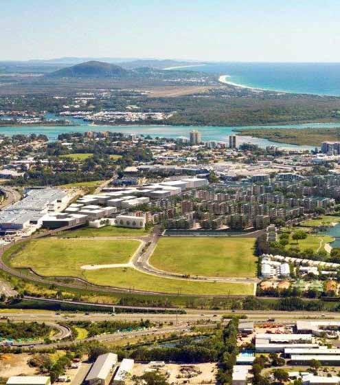
5 Strategic Strategic Context Context - Location Location Maroochydore is a coastal urban area located on the Sunshine Coast in South East Queensland. It is approximately 100 kilometres north of Brisbane and is surrounded by natural assets - beaches, rivers and national parks. Maroochydore has an existing number of important functions accommodating major retail centres, government services, and residential areas for permanent residents and holiday makers alike. The PDA adjoins a number of existing urban precincts including the traditional town centre to the north, a regional shopping centre (Sunshine Plaza) to the north-west, and the Maroochydore Homemaker Centre adjoins the PDA to the west. The Aerodrome Road precinct and residential areas lie to the east of the PDA. Map 1 (Maroochydore City Centre Priority Development Area Boundary), shows the PDA boundary and location. 1 Map 1 : Maroochydore City Centre Priority Development Area Boundary The Maroochydore City Centre PDA is a 62 hectare site located centrally within Maroochydore on land including the former Horton Park Golf Course, State Government owned land, road and drainage reserve. The Caboolture to Maroochydore Corridor Study (CAMCOS) rail alignment is located to access the PDA from the south and to terminate at the north of the PDA, running near to the western boundary. 6 Comprising a largely undeveloped parcel of land in State Government and Council ownership, the PDA is located in the heart of Maroochydore and within walking distance of the coastline, with major roads surrounding it, including Maud Street, Maroochy Boulevard, Aerodrome Road and Plaza Parade Maroochydore State School Maroochydore Police Station Maroochydore Magistrates Court Sunshine Plaza Map is intended for illustration purposes only and unless stated is not to scale. Produced by Economic Development Queensland (EDQ) Big Top Shopping Centre Maroochydore Homemaker Centre 2
6 2.0 Strategic Context - Vision 2.2 Vision The Maroochydore City Centre PDA will be the business, community services and employment focus for the Sunshine Coast, with a diverse range and choice in housing and an efficient and effective multi-modal public transport system. Development within the Maroochydore City Centre PDA will: create a city heart for Maroochydore and the Sunshine Coast; deliver fully approved and serviced land for commercial, retail, residential, civic, cultural and community uses; build publicly accessible waterways as a defining feature; facilitate rail based public transport via CAMCOS and possibly future light rail; create a multi-modal public transport system; deliver a new road network to provide additional capacity to the existing road network within Maroochydore; provide interconnected public open space; and establish a central Sunshine Coast location for regional entertainment and convention facilities. A Centre of Economic Growth Development in the Maroochydore City Centre PDA will deliver an integrated, new city centre that will support and promote existing areas in Maroochydore. Accordingly this will contribute to delivering economic and employment self-containment to the Sunshine Coast region. Growth of the new city centre will provide a mix of uses, activities and development opportunities that will attract economic, commercial and social investment, both on a national and international scale. It will deliver regional employment opportunities as the identifiable centre for business, retail, services, cultural and commercial activity. A Walkable City Centre The new city centre will place high importance on walking and cycling as the key mode of transit. Safe, shaded and well connected linkages will promote and improve non-vehicular movement both within the new city centre as well as providing linkages to surrounding land uses, open space, parkland, other retail and service areas, and the coastline. A Transit Oriented Centre The future investment and delivery of transit infrastructure - including both passenger and light rail - within Maroochydore will promote the new city centre as a key multi-modal hub within the Sunshine Coast. This will provide direct access and connectivity between local and regional centres, open space and coastal attractions. A Sustainable New Centre The growth and development of the new city centre provides the opportunity to implement new technologies, processes and environmental targets that will promote a cleaner, healthier and socially responsive future for Maroochydore. These will include subtropical design, energy efficiency, water cycle management, transit infrastructure and social and community facilities. A Beautiful and Attractive Centre New coastal contemporary buildings will overlook parklands, a large central lake, unique waterways or wide landscaped boulevards. Waterways and parklands will extend to where buildings may be positioned, creating openness and bringing sunshine, breezes and scenic vistas into the new city centre. These new places will create ideal settings for retailing, offices, entertainment uses, restaurants and new residential accommodation. A Vibrant and Engaging Centre A variety of activities, uses and lifestyle opportunities within the new city centre will provide a range of safe, active and enjoyable places that are used frequently, both day and night, at all times of the year and by a wide cross section of the community. The new city centre will include a number of local, regional and tourism focussed destinations and activities. A Safe and Inclusive Centre The public realm will be a safe, inclusive and appealing environment for residents, visitors and workers within the new city centre, both day and night. Careful planning and design will ensure local streets, parkland and open spaces are integrated with surrounding land uses, have a wide range of activities and will be highly valued by the community. 3


7 Strategic Context Strategic - Structural Context elements Structural Elements The structural elements are identified in Map 2 (Structural Elements Plan). The structural elements show how the vision will be physically expressed in the PDA. Development within the PDA should support the delivery of the following elements: A New City Centre Provides the widest range and highest order of future retail, commercial, administrative, community, cultural, and entertainment activities at an intensity and compactness that creates a true city centre for Maroochydore and the Sunshine Coast. Incorporates civic, government, recreation and cultural functions of regional significance. Positions the new city centre to the north-east of the PDA to integrate with and influence surrounding land uses and future development opportunities beyond the PDA. Provides a significant range and amount of public open space including malls, plazas, parks, gardens, waterways and promenades. Provides opportunities around the periphery of the new city centre for land uses that either need larger land areas to establish or are for uses that generally complement traditional city centre functions, without the need to be located in the new city centre. Uses respond to their location on key arrival corridors to the city centre and provide high quality built form and landscaping. An Integrated Retail Function Provides the highest concentration of core retail uses that, in conjunction with the existing regional shopping centre (Sunshine Plaza), form the retail centre for all of Maroochydore. Provides complementary retail uses in appropriate locations to activate and generate movement between the new city centre, parklands, and other key attractions and areas. Creates a public pedestrian promenade that links Sunshine Plaza with the transit interchange and new city centre, along the Maud waterway. 4
8 2.0 Strategic Context - Structural elements Residential Value Creates an urban village framed by the retail core, transit interchange and central parkland, suitably located to optimise amenity and convenience. Provides for permanent residential and tourist accommodation to be provided at an appropriate scale that supports growth and choice within the PDA, and integrates with and enhances existing Maroochydore living. Provides a range of dwelling types and sizes to facilitate social mix, meet changing demographic needs and opportunities for affordable living. Allows park vistas and park access at the end of each local street. Aligns blocks east to west to maximise buildings having a northern aspect. Parklands and Water Provides significant public open space areas including malls, plazas, parks and gardens. Provides a large central parkland that connects to a variety of high quality and integrated urban parks and waterways. Provides for a parkland focus on the Maud waterway and provides for a wide range of informal active and passive recreation facilities and gathering spaces. Creates an urban water feature through the realignment of the Maud waterway to act as the Corso - a primary movement corridor and pedestrian promenade. Incorporates development around a central lake and water passages as a value adding community asset and destination. Accommodates flood storage in the PDA, with an area of not less than 8.4 hectares. Landscape and open space reinforces the new city centre s subtropical and coastal lifestyle, climate and identity. Community Assets Establishes a civic focus and identity for Maroochydore. Creates a significant community asset a key anchor use, gathering place and community focal point on land designated to the north of the central parkland, and within walking distance of the future transit interchange. Creates high quality and permeable connections that link the PDA to existing civic uses to the north, via high quality open space, public transport, cycle ways and streetscapes. Road and Infrastructure Network Establishes a robust and permeable city grid pattern connecting into the surrounding road network, improving accessibility and permeability into and across the PDA, and to the broader Maroochydore areas. Establishes appropriate access points (through development or land acquisition) to integrate the city grid and connect the PDA to the surrounding road network and development potential beyond the PDA. Creates strong vehicular and nonvehicular linkages external to the PDA. Maximises access to public transport and encourages walking and cycling. Integrates suitable active land uses in alignment with the future transit interchange, light rail and existing transit interchange. Provides suitable interim land uses that support or allow for future infrastructure around identified transport corridors, alignments and interchanges. 5
9 Strategic Context - Structural elements 2.0 Map 2: Structural Elements Plan Legend New City Centre and Integrated Retail Core Other Development Parkland Key community / entertainment facilities PDA Boundary Major Boulevard Roads Urban Open Space Links Lakes and Waterways Future Light Rail (indicative alignment subject to further investigations) Future Passenger Rail Infrastructure (CAMCOS) 6
10 3.0 Land Use Plan - Operation 3.1 Operation of the Land Use Plan Purpose of the Land Use Plan The Land Use Plan establishes the PDA development requirements that regulate development to achieve the vision for the PDA. The Land Use Plan seeks to facilitate development of the PDA and enable longer term development to occur that is consistent with the vision and contributes to the delivery of the PDA PDA Development Requirements The PDA development requirements are expressed as: (i) PDA-wide development criteria (see section 3.3) (ii) Precinct provisions (see section 3.5). The PDA-wide development criteria apply to all assessable development in the PDA but do not apply to exempt development. The precinct provisions for each precinct apply to: (i) land in that precinct (precinct intents and preferred land uses) (ii) all development in that precinct (Precinct Levels of Assessment Tables). The Department of State Development Infrastructure and Planning (DSDIP) guidelines provide guidance on how to achieve the PDA-wide development criteria and Precinct provisions Levels of Assessment Levels of assessment tables in Section 3.5 prescribe for each precinct: (i) PDA exempt development (column 1) (ii) PDA self-assessable development (column 2) (iii) PDA assessable development which is permissible (column 3A) (iv) PDA assessable development which is prohibited (column 3B) Schedules Schedule 1 identifies development that is exempt from assessment for the whole of the PDA. Schedule 2 provides the use and administrative definitions required to interpret and apply the development scheme. Figure 1: Purpose of the Land Use Plan and relationship of development scheme components Vision (including Structural Elements) PDA Development Requirements PDA-wide development criteria Urban design and sustainability Centres design and function Maximum development yields Street and movement network Environment and open space Community safety and development constraints PDA-wide exempt development Definitions Schedules Precinct provisions Structural elements plan (Map 2) and Zones and Precincts Plan (Map 3) Precinct provisions Levels of Assessment Tables (Section 3.5) Precinct Plans DSDIP Guidelines 7
11 Land Use Plan - Development Assessment Development assessment Interpretation Section 33 of the Act defines development. Schedule 2 defines particular words used in this scheme, including uses and administrative terms Development Application To the extent the PDA-wide development criteria, zone intents, precinct provisions and the DSDIP guidelines are relevant, they are to be taken into account in the preparation of a PDA development application and the assessment of the application by the MEDQ. The Infrastructure Plan and Implementation Strategy may include further information which should be taken into account in the preparation, design and feasibility of development proposals Development approval Identification of development as PDA assessable development does not mean that a PDA development approval (with or without conditions) will be granted. PDA assessable development requires a PDA development application to be lodged with the MEDQ for assessment and decision. Approval of a development permit is required before PDA assessable development is undertaken Development consistent with the Land Use Plan PDA assessable development is consistent with the Land Use Plan if: a. the development complies with all relevant PDA-wide development criteria, zone intent, precinct provisions and precinct plan; or b. the development does not comply with one or more of the aspects of the PDA-wide development criteria, zone intents, precinct provisions or precinct plan but: i. the development does not conflict with the PDA vision; and ii. there are sufficient grounds to justify the approval of the development despite the non compliance with the PDA-wide development criteria, zone intents, precinct plan or the precinct provisions. In this section grounds means matters of public interest which include the matters specified as the main purposes of the Act as well as: a. superior design outcomes; and b. overwhelming community need. The term grounds does not include the personal circumstances of an applicant, owner or interested third party Development Inconsistent With The Land Use Plan PDA prohibited development is inconsistent with the Land Use Plan. Under the Act, PDA assessable development that is inconsistent with the Land Use Plan cannot be granted approval Demonstrating development is consistent with the Land Use Plan PDA assessable development must demonstrate how it is consistent with the PDA vision, PDA-wide development criteria and precinct provisions and should demonstrate that development will not compromise or unreasonably prejudice opportunities for the development of the remaining area in the precinct. Suggested ways applicants may demonstrate this is through a preliminary approval or Plan of Development (PoD) Precinct Plan Requirement Prior to the approval of a Plan of Development (PoD) or the first development application for permissible development, a (Precinct Plan) must be approved. A Precinct Plan must be approved for each of the Precincts nominated on Map 3 (Zone and Precincts Plan). The Precinct Plan must demonstrate how the precinct intent and precinct outcomes are achieved and include the following: i. the nomination of sub-precincts to which a PoD may apply; ii. how the maximum yields for the precinct will be achieved including the anticipated scale and distribution of land uses for each precinct; and iii. any additional development requirements for the sub-precinct in order to achieve the required precinct outcomes. A Precinct Plan must be consistent with the PDA-wide development criteria, zone and precinct intent. 8
12 3.0 Land Use Plan - Development assessment Preliminary Approval There is no requirement to obtain a PDA preliminary approval 1. However, applicants may choose to use preliminary approvals to stage development or to gain approval for a development concept before undertaking detailed planning. In this regard preliminary approvals may demonstrate how development achieves the requirements of the development scheme at an intermediate level of spatial planning between the broad spatial framework of the Structural Elements Plan (Map 2) and precinct provisions and the individual development proposals and associated Plans of Development (PoDs). A preliminary approval may include the following:- i. all or a relevant part of the precinct determined in consultation with the MEDQ ii. identify the location of connections to network infrastructure, including transport, within the precinct 1 A PDA preliminary approval is a PDA development approval that approves development subject to conditions, but does not authorise PDA assessable development to take place. A PDA development permit is required in order to carry out PDA assessable development. iii. identify land uses and development density iv. resolve if required, any development constraints that may determine the extent of the developable area or appropriate uses v. resolve the boundaries of centres, public open space and any identified sites for community infrastructure, and vi. demonstrate that the development proposal: ¾ does not prejudice the ability for surrounding land to be developed in an orderly and efficient manner consistent with the PDA vision, PDA-wide development criteria and precinct provisions ¾ addresses additional requirements for development in the precinct ¾ is consistent with existing and approved development in the preliminary approval area or adjoining areas ¾ addresses other matters specified in a guideline issued by DSDIP. Applicants should discuss the use of a preliminary approval with the MEDQ Plan of Development A Plan of Development (PoD) may accompany an application for a material change of use or reconfiguring a lot and may deal with any proposed use as well as operational work. A PoD is prepared by an applicant and may include maps, graphics and text that collectively demonstrate how proposed uses, works and lots will contribute towards the achievement of the vision and will be consistent with the relevant PDA development requirements and precinct provisions. A PoD should indicate the location and function of temporary and permanent uses and structures and how these uses and structures will relate to each other. The PoD cannot include land beyond the boundary of the land the subject of the application, but may cover only part of the land the subject of the application. An applicant may also be required to demonstrate impacts and connections to areas adjoining the subject land in a separate plan to the PoD. Under the precinct Levels of Assessment Tables, development approved in accordance with a PoD is exempt development and requires no further development approval under the scheme Infrastructure Agreements A PDA development condition may require the land owner to enter into an infrastructure agreement to address the provisions and requirements of the Infrastructure Plan and Implementation Strategy Notification Requirements A PDA development application will require public notification if the application: - a. includes a proposal for development which does not comply with Map 2 (Structural Elements Plan) and Map 3 (Zones and Precinct Plan), their intent or the precinct provisions; or b. is for development which in the opinion of the MEDQ, may have adverse impacts on the amenity or development potential of adjoining land under separate ownership, including development for a non-residential use adjacent to land approved for or accommodating a residential use in the residential precinct. The MEDQ may require public notification in other circumstances if the development application is for a use or of a size or nature which, in the opinion of the MEDQ, warrants public notification. 9

 or other legislation. However, the development scheme prevails to the extent of any inconsistency with those instruments. 3.2.")
13 Land Use Plan - Development Assessment Relationship with local government planning scheme and other legislation The development scheme may apply a provision of a planning instrument or a plan, policy or code made under the Sustainable Planning Act 2009 (SPA) or other legislation. However, the development scheme prevails to the extent of any inconsistency with those instruments Other legislation In addition to assessment against the development scheme, development may require assessment against other legislation including for example the Plumbing and Drainage Act 2002 and the Sustainable Planning Act Land not included in a precinct This section applies to land which is not shown in the Land Use Plan as being included in a precinct (unallocated land). Where the unallocated land adjoins land in a precinct, the unallocated land is deemed to be included in that precinct. Where the unallocated land adjoins land included in different precincts, the unallocated land is deemed to be included in those precincts with the centreline of the unallocated land being the boundary between the precincts Interim use An interim use is a land use that, because of its nature, scale, form or intensity, is not appropriate for long term use of the land. Interim land uses may occur if appropriately developed and operated and where located in areas which will not compromise the precinct provision in the longer term. The MEDQ may approve an interim use if it can be demonstrated that an interim use will not preclude or delay an appropriate long term use or intensity of development. Information to support an application for an interim use may include:- a schedule of land supply and projected take-up rates, or plans showing how the development could transition from the proposed interim use to an appropriate longer term use. The MEDQ may impose a condition of approval that limits the duration of an interim use. Interim uses will only be approved if it can be demonstrated that the use will not prejudice the achievement of the vision for the PDA. 10
14 3.0 Land Use Plan - PDA-wide development criteria 3.3 PDA-wide development criteria The following criteria apply to all PDA assessable development in the Maroochydore City Centre PDA. To the extent that the criteria are relevant, they are to be taken into account in the preparation of PDA development applications and the assessment of those applications 2. The PDA-wide development criteria support the delivery of the structural elements expressed in Section 2.3 and Map 2 (Structural Elements Plan). The PDA-wide development criteria should be read in conjunction with the relevant precinct provisions. The Infrastructure Plan and Implementation Strategy may include further information, which should be taken into account in the design and feasibility of development proposals. For more detail regarding how to comply with the specific development requirements listed below refer to relevant guidelines. 2 Applicants should have regard to the State Planning Policy (SPP) December 2013, associated guidance and supporting material including mapping Urban Design and Sustainability Neighbourhood planning The form, type and arrangement of streets and open space: a. achieves good neighbourhood planning and design outcomes; b. contains significant residential and non-residential uses consistent with the PDA vision; c. provides a mix of lot sizes and range of urban forms to accommodate mixed use, commercial, residential, community use and retail functions; d. delivers a varied pattern that connects into the existing street grid which is permeable and legible, promoting walking and cycling; e. achieves an appropriate interface with existing residential and commercial development adjoining the PDA boundary by: i. considering densities through minimum lot sizes and the location of property boundaries; ii. access arrangements; iii. uses; and iv. height; and f. Supports a range of residential options and innovations within the PDA to reflect opportunities for student, live-work, and other housing types Placemaking Development is to: a. contribute to a sense of place; b. provide a strong identity expressed through architecture, urban design, landscaping and appropriate signage at key locations; c. establish public spaces which contribute to a variety of activities in the public realm; d. provide a safe environment through the application of Crime Prevention through Environmental Design (CPTED) principles such as passive surveillance through residential neighbourhoods and open spaces; e. provide for landmark buildings to create gateways and way-finding landmarks; f. create an attractive and appealing place for residents which promotes walking and cycling and is permeable, legible and connected to surrounding areas; g. provide for new and future technologies in the public realm which may include fibre optic to all lots, wi-fi connectivity, LED street lighting, smart lighting, smart traffic lights, smart parking systems and video surveillance of open space, streets and public realm; and h. provide a relaxed, casual and outdoors oriented centre, through the integration and connection of water and parkland within and around the city streets, buildings and parklands Built Form The form of buildings delivers: a. high design standards and contributes to overall new city centre qualities; b. site responsiveness which: i. creates a recognisable town centre through the intensity, appearance, height, scale and mass of built form; ii. delivers building heights and densities which are appropriate in the context of surrounding development and the precinct provisions in Section 3.5; 11
15 Land Use Plan - PDA-wide development criteria 3.0 iii. provides building setbacks that are sufficient to ensure the building: ¾ does not dominate the street or neighbouring built form; ¾ does not prejudice the development of adjoining sites; ¾ creates attractive and viable communal spaces and deep planting zones at the front and rear of the building; and ¾ has access to sufficient light and ventilation; iv. provides built to boundary (0m setbacks) on front and side boundaries only; v. ensures ground and podium levels of the building contribute to a fine grained, articulated streetscape, exhibiting human scale and creating interest in the facade; vi. ensures buildings address the street and integrate with the public realm to support pedestrian connectivity and activity; viii. ensures buildings located on the boundaries of the PDA are designed to provide an appropriate transition to buildings on adjoining sites; c. Building detail which: i. allows for larger consolidated floor plates for commercial development; ii. ensures floor plates and ceiling heights provide for flexibility and consideration for future technologies and uses; iii. allows for rooftop terraces, landscaping, entertainment and lifestyle uses on podium and lower levels that overlook the main street boulevard, plazas and parklands; iv. maximises recycling opportunities and reduces waste generation; and v. ensures adequate visual and noise amenity; and d. Sub-tropical design which: i. ensures residential design provides safety, privacy, comfort and responsiveness to the Sunshine Coast s sub-tropical climate; ii. ensures optimum solar access and north facing orientation for residential uses where possible to respect the local climatic opportunities; iii. utilises energy efficient, climatically responsive design including appropriate solar orientation, shading, cross ventilation, natural lighting and passive cooling techniques; and iv. incorporates green walls or roofs where possible to create feature elevations and reduce heat sink effects Affordable Living Residential development (including residential components of a mixed use development) should deliver housing choice to suit a variety of households including: families, singles, couples, workat-home occupiers, students, retirees, group accommodation households and people with special needs, by offering universal design and a variety in size, configuration, cost, location and tenure. Development: a. Contributes to affordable living 3 ; b. achieves housing choice and diversity; c. incorporates universal design; and d. incorporates adaptable housing. 3 Refer to: vii. maximises views to parks and waterways for buildings and streets; and ¾ EDQ Guidelines and Practice Notes, and specifically to Guideline 2 - Accessible Housing, on the DSDIP web-site resources/priority-development-areas-guidelinesand-practice-notes.html ; ¾ Sunshine Coast Affordable Living Strategy
16 3.0 Land Use Plan - PDA-wide development criteria Centres Design and Function Future development: a. delivers the vision for a new city centre for Maroochydore and the Sunshine Coast; b. delivers a new and identifiable heart for the Sunshine Coast that will attract economic, commercial and social investment, whilst also creating an attractive and appealing place for residents, workers and visitors; c. ensures that future transit infrastructure creates an accessible centre, well connected to the surrounding urban area and subregion, through the provision of corridors for passenger and light rail directly into the new city centre; d. delivers sites for a new significant community facility, library, civic uses and entertainment, exhibition and convention centre, all of which are connected and set within high quality parkland, water ways and landscaped boulevards; e. provides retail opportunity on the ground floor in identified mixed use precincts; f. provides sufficient car parking through an integrated and convenient car parking layout; and g. embraces new technologies, including digital and broadband, in order to expand business markets and compete nationally and globally Maximum Development Yields The maximum development yield for the PDA allowable under this development scheme will be in the order of: ¾ Retail - 75,000m 2 GFA; and ¾ Commercial - 165,000m 2 GFA While no maximum yield is placed on residential development in the PDA, it is intended that around 2,000 residential dwellings will be provided as a key outcome for the PDA. Yield intents for precincts are described in Section The maximum development yields for the PDA are derived from the capacity of the currently planned infrastructure networks for the PDA, in particular the road transport infrastructure network. Development seeking to exceed the GFA limits specified above will be assessed under Section b of the development scheme Street and movement network Development provides for a well designed street and movement network which: a. creates an accessible centre, well connected to the surrounding urban area and sub-region, providing for future transit corridors for passenger and light rail; b. provides a range of street typologies that respond to the development intent of each precinct and specific outcomes of the overall city street hierarchy as shown in Map 6 (Road Hierarchy Plan); c. has a clear structure and maximises walking, cycling and public transport effectiveness in that pedestrian and cyclist links are direct, convenient, legible, comfortable and safe and connect with all major land uses, key destinations, public transport and existing transit infrastructure; d. connects to and takes into consideration impacts to existing networks, ensuring acceptable levels of amenity and minimising negative impacts of through traffic; e. provides well designed lighting, pavement treatment and materials, clear sight lines and landscaping 5 ; f. makes adequate provision for public transport infrastructure including bus stops and indent bays at appropriate locations in conjunction with Translink; g. provides end of trip facilities for pedestrians and cyclists, including secure undercover bicycle storage facilities, showers and lockers; 4 A Precinct Plan that seeks to exceed the maximum development yield must be accompanied by: (a) an infrastructure network analysis that demonstrates that the additional yield will not compromise the planned infrastructure networks for the PDA, in particular the planned transport infrastructure network; and (b) an economic impact assessment for additional retail proposed for precincts other than Precinct 3 (Retail Core) that demonstrates: (i) how the proposed additional area will complement and not compromise the Maroochydore Principal Regional Activity Centre and the Sunshine Coast Centres Hierarchy; and (ii) that the additional yield provides for increased employment opportunities within the PDA. 5 Refer to Austroads - Guide to Road Design Part 6A - Pedestrian and Cycle Paths. 13
17 Land Use Plan - PDA-wide development criteria 3.0 h. provides cycle parking in the public realm; i. does not unreasonably constrain future provision of public transport infrastructure and does not adversely impact on existing or future public transport corridors; j. ensures potential public transport routes are constructed to a standard appropriate to accommodate services, footpaths and pavements; k. ensures vehicle access and parking is safe and convenient for residents, workers, visitors and service providers; l. provides for a range of off-street parking options that may service both non-residential and residential uses; and m. ensures any car parking structures are suitably sleeved. Table 1: Maroochydore City Centre PDA Car Parking Rates Land Use Interim Long Term (prior to the provision of first high capacity mass transit 6 public transport service) (after the provision of first high capacity mass transit 6 public transport service) Residential 1 space per dwelling unit 1 space per dwelling unit Commercial 1 space per 40m 2 GFA on-site 1 space per 80m 2 GFA Retail Services, community and other uses 50% to be provided on-site 50% may be provided in a shared centrally located and managed interim car parking facility or fees paid in lieu of off-site car parking, in accordance with a car parking infrastructure agreement. 1 space per 20m 2 GFA 30% to be provided on-site 70% may be provided in a shared centrally located and managed interim car parking facility or fees paid in lieu of off-site car parking, in accordance with a car parking infrastructure agreement. 1 space per 20m 2 GFA Where the applicant can provide technical assessment that demonstrates suitable alternative car parking provision for uses under this category, the alternative rates will be assessed by the assessment manager based on relevant merit. 1 space per 40m 2 GFA 1 space per 20m 2 GFA Development makes adequate car parking provision for the number and nature of vehicles expected and in compliance with Table 1 (Maroochydore City Centre PDA Car Parking Rates). 6 High Capacity Mass Transit is defined as light rail, passenger rail (CAMCOS) or high frequency dedicated bus service. 14
18 3.0 Land Use Plan - PDA-wide development criteria Environment and open space Open Space Development for open space in the PDA: a. incorporates the following key components: i. major parkland; and ii. an urban waterbody of not less than 8.4 hectares in area; b. connects parks and open space within and adjoining the new city centre, to be accessible for all users as pedestrian and cycle friendly environments; c. accommodates a wide variety of uses, activities, themes and purposes for both day and night time activities; d. provides high levels of access to a public open space and a civic plaza that serves as a community focal point and gathering place; e. treats the Maud waterway as a key landscape feature that supports interconnectivity in the new city centre and to broader urban areas; f. incorporates public art; g. provides a public pedestrian promenade - the Corso - extending along the full frontage of the Maud waterway to the future transit station and interchange; h. integrates adjacent built form to overlook public open space and parklands, providing active frontages, passive surveillance and value adding frontages; i. provides safe and well lit public open space by applying Crime Prevention Through Environmental Design Principles (CPTED); j. delivers shade structures, landscaping and directional signage in public domain areas; k. provides safe public footpaths, cross block links and pathways that have a high level of accessibility and are quality pedestrian and bicycle environments; and l. capitalises on the value and amenity of waterways by maximising public accessibility Environment Development in the PDA: a. will be sensitive to environmental matters; b. adequately addresses any environmentally significant matters, including any disturbance of marine plants; c. seeks to incorporate tidal fish habitats and fish passage within waterways, specifically the realignment of the Maud Street drain 7 ; d. protects and retains where possible ecological values, existing mature trees including hollow bearing trees, remnant vegetation and fauna habitat; e. incorporates landscaping with endemic species with a preference towards retaining existing endemic vegetation where possible; f. utilises planting strategies that are site responsive and reflect the subtropical nature of the Sunshine Coast; and g. minimises adverse impacts on receiving waters and appropriately manage stormwater including use of water sensitive urban design principles. 7 Refer to: Fisheries Guidelines for Fish-friendly structures, Fish Habitat Guideline FHG
19 Land Use Plan - PDA-wide development criteria Community safety and development constraints Development is to: a. be sited, designed and constructed to avoid, minimise or withstand the incidence of a development constraint; b. ensure that people and property are safe from potential hazards including acid sulfate soils, flooding, and coastal hazards 8 ; c. ensure that building and/ or structures do not intrude into the Obstacle Limitation Surface (OLS) for the Sunshine Coast Airport 9 ; d. ensure the design, siting, and layout of development adjoining the public transport rail corridor addresses noise impacts and where necessary incorporates noise mitigation measures; e. take into account the projected impacts of a variable climate; f. manage and minimise noise from transport corridors 10 ; and g. minimise adverse impacts on amenity during construction Natural Disaster Resilience To ensure suitable natural disaster resilience 11, development: a. ensures that the finished ground surface levels of lots after building development are above the defined flood event 12 to protect the development from the risk of flooding; b. allows that undeveloped lots subject to subsequent building work likely to involve basement excavation, may temporarily have lower ground surface levels which may be raised to above the defined flood event at the time of building work utilising fill material from basement excavation works; and c. ensures all lots are free draining, avoid pondage of stormwater and do not cause adverse amenity impact or other nuisance. Development provides an efficient drainage network 13 which: a. provides capacity for stormwater discharge; b. minimises flood risk from major rainfall events; and c. does not result in adverse impacts upstream or downstream. 8 Refer to: ¾ State Planning Policy (SPP) December 2013, associated guidance and supporting material including mapping. ¾ relevant DSDIP guidelines. ¾ Cornmeal Creek Flood Study - November 2013 prepare by Cardno. 9 Refer to Regulatory Map 1.8 Sunshine Coast Airport Obstacle Limitation Surface of the Sunshine Coast Council s Maroochy Plan Refer to the Department of Transport and Main Roads Traffic Noise Management: Code of Practice with respect to external road traffic noise levels; and the Queensland Development Code and Section MP4.4 Buildings in a Transport Noise Corridor. 11 NB The Queensland Reconstruction Authority notes the Flood Hazard Overlay Map OVM51H (draft Sunshine Coast Planning Scheme 2012) identifies a significant portion of the site affected by river and storm tide flooding. Development in these areas must ensure it does not increase the inherent risk of people and property to the potential impacts of flooding. Development should be able to remain functional during and after a natural hazard event. 12 Defined flood event is the ARI 100 (climate change) flood event. (refer to the Cornmeal Creek Flood Study - Nov 2013 prepared by Cardno. 13 Refer to the State Planning Policy (SPP) December 2013, associated guidance and supporting material including mapping and the Urban Stormwater Quality Planning Guidelines
20 3.0 Land Use Plan - PDA zones 3.4 PDA Zones High Density Residential Zone 3.5 Precinct provisions Precinct 3 - Retail Core Precinct Land within a PDA may be allocated a zone. The zones are grouped in the following three categories: Principal Centre (CBD) Zone, High Density Residential Zone and Recreation and Open Space Zone. The zones in the PDA are described below. Principal Centre (CBD) Zone The purpose of the Principal Centre Zone is to provide for the largest and most diverse mix of uses and activities that form the core of the urban centre. It includes key concentrations of high order retail, commercial, employment, residential, administration, community, cultural, recreational and entertainment activities and other uses capable of servicing the region. The purpose of the High Density Residential Zone is to provide for medium and high density residential activities predominantly comprising multiple dwelling residential development for permanent residents supported by community facilities and small-scale services and facilities that cater for local residents. Recreation and Open Space Zone The purpose of the Recreation and Open Space Zone is to provide for a range of recreation, leisure, cultural and educational activities. The zone provides for parks that serve the recreational needs of residents and visitors Introduction Eight precincts are identified in the PDA. These precincts and their locations are shown on Map 3 (Zones and Precincts Plan). The precincts are as follows: Precinct 1 Maroochydore Parklands Precinct Comprises key urban green space elements, including the central east-west public promenade green spine - the Corso, - central parkland, the lakelands centre piece, a civic plaza, recreation parks and gathering spaces, and a regional library. Precinct 2 - Community Facilities and Entertainment Precinct A community heart for Maroochydore, with major entertainment, tourism and community activities, integrated into the adjoining Maroochydore Parklands Precinct with high quality landscape and waterway treatments, public art and plaza spaces; and incorporating high sustainability and energy efficiency targets. Comprises a highly pedestrianised and high intensity mixed use core with the highest concentration of retail floor space in the PDA. Precinct 4 - Commercial Precinct Comprises predominantly medium intensity commercial development and employment uses providing for larger floor area uses. Precinct 5 - Main Street South Precinct Predominantly medium and high intensity residential and commercial development with significant permanent residential and some lower levels of offices above the ground storey. 17
21 Land Use Plan - Precinct provisions 3.0 Map 3: Zones and Precinct Plan 1. Maroochydore Parklands 3. Retail Core 4. Commercial 6. Main Street North Legend 5. Main Street South 2. Community Facilities & Entertainment Principal Centre (CBD) Zone High Density Residential Zone Recreation and Open Space Zone Lakes and Waterways Future Light Rail subject to further investigations Future Passenger Rail Infrastructure (CAMCOS) 8. Dalton Drive 1. Maroochydore Parklands 7. Residential Precinct Boundary Roads 1... Precincts 18
22 3.0 Land Use Plan - Precinct provisions Precinct 6 - Main Street North Precinct Intended predominantly for high intensity residential uses with some commercial capacity at ground and podium levels as well as cafe and retail uses to activate the ground floor frontages. Precinct 7 - Residential Precinct Intended for predominantly medium intensity residential uses with some limited ground floor convenience retail and cafe uses adjacent and overlooking the Southern Lake. Precinct 8 Dalton Drive Precinct Intended to accommodate a range of land uses which deliver a scale, character, intensity and function of development suited to the periphery of the new city centre and compatible with adjoining uses, recognising the role of Dalton Drive as a primary arrival corridor to the new city centre, and providing high quality built form and extensive landscaping to these key frontages Precinct Provisions Precinct provisions seek to provide guidance on where land uses and development within the PDA are preferred and to support the achievement of the longer term development of the PDA. Interim uses, should however have regard to the impacts on the longer term development of the PDA and ensure the delivery of infrastructure including the street and movement network, is consistent with the PDA-wide development criteria, zone intent and precinct provisions. Precinct provisions should be read in conjunction with Section 2.3 Structural elements and Map 2 (Structural Elements Plan), zone intents and the PDA-wide development criteria. Inclusion of land within a precinct does not imply that all such land can be developed for urban purposes. Some land may not be available or appropriate to be developed due to local site conditions or other constraints including the need to provide roads or open space etc. This will need to be addressed through a development application or precinct plan. Development should have regard to the Infrastructure Plan. 19
 Key ground floor plaza, building entries and corner elevations Primary frontages and")
23 Land Use Plan - Precinct provisions 3.0 Map 4 : Precinct Development Principles Plan Legend Precinct boundary 6m Upper level setbacks (Levels 4+) Key ground floor plaza, building entries and corner elevations Primary frontages and elevations- no vehicular access Roads Indicative basement and servicing access- location subject to building design Landscape buffers - min. 20m Key elevation treatment to parkland and canals - no vehicular access with exception of laneway alignment Articulated screening + elevation to rail corridor- limited vehicular access permitted Future Light Rail subject to further investigations Future passenger rail infrastructure (CAMCOS) Landmark building - 20 storeys Iconic building - 25 storeys Iconic building Community facilities building Principal Centre (CBD) Zone High Density Residential Zone Recreation and Open Space Zone Lakes and Waterways 20
24 3.0 Land Use Plan - Precinct provisions Precinct 1 - Maroochydore Parklands Precinct Precinct Intent The Maroochydore Parklands Precinct is intended to become a major community and regional destination for informal recreation, respite and community activities. It will comprise a major linear parkland and lake. It will be a high quality urban park with open lawns, shaded picnic areas, play equipment, public amenities and passive recreation uses. Adjacent retail, commercial, community and residential uses will address and overlook the park; providing surveillance, address and ownership of this key public open space asset. Precinct Outcomes Development within the Maroochydore Parklands Precinct achieves the following: a. comprises urban open space providing the Corso green spine, central parklands and lakelands centre piece in the PDA; b. includes a lake that is appropriately sized and designed to provide for stormwater management and act as a defining feature of the central parklands; c. realigns the Maud waterway to provide a key landscape and recreational feature; d. connects internal precincts and external land uses; e. accommodates a civic plaza, linear recreation park, local recreation park and gathering spaces; f. integrates with adjacent development and built form and visually, functionally and physically integrates with the Community Facilities and Entertainment Precinct; g. incorporates landscaping with endemic species with a preference towards retaining existing remnant vegetation where possible; h. protects ecological values and incorporates appropriate erosion and sediment control techniques; and i. on-site stormwater management measures ensure water quality and maintain aquatic ecosystem values. The Maroochydore Parklands Precinct will comprise five core elements: 1. Central Lakelands - A series of parkland platforms focused around the central lake. The parklands may provide: ¾ Open kick and throw areas; ¾ Shaded picnic areas, benches and seating; ¾ Public amenities; and ¾ Boardwalk and lake side terraces. 2. Southern Lakelands - A continuation of the central lake to the south, to create a more natural and passive area of open space. The Southern Lakelands may incorporate: ¾ Multi-use path and trail network; ¾ Fitness equipment; ¾ Play areas; ¾ Wetlands and bio-filtration devices; ¾ Canoe and Kayak launch areas; and ¾ Sufficient car street parking. 3. The Corso - A wide linear parkland including the realignment of Maud waterway, a wide linear park along the south bank, and integrated plaza spaces. The Corso may deliver: ¾ Plaza areas interfacing with Maud waterway; ¾ Shaded picnic areas and seating; ¾ Public amenities; and ¾ Boardwalks and promenades. 4. Civic Plaza - A highly accessible community gathering area, including library, play space, open lawns and pathway connections. The Plaza may include: ¾ Library; ¾ Durable plaza / public square; Children s play space; ¾ Public art and sculpture court; ¾ Open lawns; and ¾ Planted buffer to adjoining residential. 21

25 Land Use Plan - Precinct provisions Transit Plaza - A robust, attractive and shaded plaza space that is integrated with the transit interchange and adjacent retail uses. The Transit Plaza may provide: ¾ Durable plaza space; ¾ Shaded seating areas; ¾ Public art and sculpture court; and ¾ Landscape gardens. Precinct 1 : Maroochydore Parklands Precinct Preferred Land Uses Preferred land uses within the Maroochydore Parklands Precinct are to include: Park Waterway Landing Ancillary convenience uses may include: Food and drink outlet The Maroochydore Parklands Precinct provides for recreational lease/ hire facilities and public berthing facility for water craft. Legend PDA Boundary Precinct Boundary Recreation and Open Space Zone Lakes and Waterways Community Facilities Building Roads Future light rail, subject to further investigation Future passenger rail infrastructure (CAMCOS) 22
26 3.0 Land Use Plan - Precinct provisions Precinct 1 Maroochydore Parklands Precinct: Levels of Assessment Column 3 PDA assessable development Column 1 Column 2 Column 3A Column 3B Exempt development PDA self assessable development Permissible development Development referred to in Schedule 1. Nil All development, including development not defined in Schedule 2, other than development mentioned in Schedule 1 or Column 1, 2 or 3B. Prohibited development 1. Extractive industry 2. High impact industry 3. Low impact industry 4. Medium impact industry 5. Special industry 6. Warehouse 7. Agricultural supplies store 8. Animal husbandry 9. Cropping 10. Intensive animal industry 23
27 Land Use Plan - Precinct provisions Precinct 2 - Community Facilities and Entertainment Precinct Precinct Intent The Community Facilities and Entertainment Precinct is intended to deliver a new entertainment and convention focus for Maroochydore and the Sunshine Coast. Located on the edge of the central lake and the new city centre, this precinct will accommodate regional level community infrastructure for major entertainment, tourism and community facilities. Integrated with high quality landscape and waterway treatments, public art and plaza spaces, the built form will reflect contemporary, sub-tropical and coastal architecture, whilst incorporating sustainability and energy efficiency targets. Precinct Outcomes Development within the Community Facilities and Entertainment Precinct achieves the following: a. community facilities and infrastructure consisting of a key civic or entertainment development and supporting uses, local community centre, meeting spaces, administration space, urban open space infrastructure; and b. a built form which frames and activates the forecourt and the other elements of the adjoining urban open space to create a human scale and pedestrian friendly environment. Development in the Community Facilities and Entertainment Precinct is to: a. align development along the Maud waterway and provide for wide shaded pathways; b. provide an iconic building in accordance with iconic building heights and design standards for key locations; d. incorporate public art and sculptural elements; e. provide wide pedestrian promenades and forecourt connecting to the southern part of the Maroochydore Parklands Precinct and the Corso; f. provides bridge concourses to connect the facility frontages to the Main Street; g. provides a wide pedestrian promenade and forecourt adjacent to the facility, alongside or over the central lake; h. provides landscape plazas for public access and open spaces for community use; and i. incorporates a landscaped buffer to provide separation between the community and entertainment facility and adjoining existing residential development. Preferred Land Uses Preferred Land Uses within the Community Facilities and Entertainment Precinct include: Major recreation and entertainment facility Community Use (including: Public Amphitheatre and Civic Plaza/ gathering place). Hotel Office Shop Food and Drink Outlet Market Parking Station c. provide high quality, durable and robust public open spaces and landscape treatment; 24
28 3.0 Land Use Plan - Precinct provisions Precinct 2 Community Facilities and Entertainment Precinct: Levels of Assessment Column 3 PDA assessable development Column 1 Column 2 Column 3A Column 3B Exempt development PDA self assessable development Permissible development Development referred to in Schedule 1. Nil All development, including development not defined in Schedule 2, other than development mentioned in Schedule 1 or Column 1, 2 or 3B. Prohibited development 1. Extractive industry 2. High impact industry 3. Low impact industry 4. Medium impact industry 5. Special industry 6. Warehouse 7. Agricultural supplies store 8. Animal husbandry 9. Cropping 10. Intensive animal industry 25
 Primary frontages and")
29 Land Use Plan - Precinct provisions 3.0 Precinct 2: Community Facilities and Entertainment Precinct Legend PDA Boundary Precinct Boundary 6m Upper level setbacks (Levels 4+) Primary frontages and elevations- no vehicular access Landscape buffers- min. 20m Iconic Building Principal Centre (CBD) Zone Recreation and Open Space Zone 26
30 3.0 Land Use Plan - Precinct provisions Precinct 3 - Retail Core Precinct Precinct Intent The Retail Core Precinct is intended to be the primary mixed use retail core within the PDA, capitalising on the proposed transit infrastructure and proximity to existing retail activity in areas adjoining the PDA. Precinct Outcomes Development within the Retail Core Precinct achieves the following: a. a high intensity mixed-use retail core that accommodates the highest concentration of retail and office floor space within the PDA; f. high quality, sub-tropical landscape design; g. public art and gateway elements; h. car parking sleeved or screened from street view; i. quality public spaces and streets with a high level of pedestrian and cyclist accessibility, and connection to surrounding precincts; j. maximum yields for this precinct are expected to be in the order of 14 : ¾ Retail - 40,000 m 2 GFA; and ¾ Commercial - 60,000 m 2 GFA; and d. opportunity for a landmark building up to 25 storeys in height, that responds to key locations in compliance with Map 5 (Maximum Building Heights); and e. opportunity for a landmark building up to 20 storeys in height that responds to key locations in compliance with Map 5 (Maximum Building Heights). Preferred Land Uses Preferred Land Uses within the Retail Core Precinct include: Shop Shopping Centre 14 A Precinct Plan that seeks to exceed the maximum b. short term or permanent residential accommodation or office uses as part of mixed-use buildings located on floor levels above any retail floors; c. lots that are a type and scale consistent with the desired built form outcomes of the precinct; d. primarily transit orientated development optimising access to public transit convenience (CAMCOS, light rail, cycle ways etc); k. approximately 600 residential dwellings. Buildings provide for: a. sculptural and articulated architectural building design; b. 1-3 storey podium height; c. up to 15 storey building height (except in 8 storey height restricted parcels) in compliance with Map 5 (Maximum Building Heights); Office Hotel Multiple Dwelling Market Indoor Sport and Recreation Food and Drink Outlet Theatre Short-term accommodation development yield must be accompanied by: (a) an infrastructure network analysis that demonstrates that the additional yield will not compromise the planned infrastructure networks for the PDA, in particular the planned transport infrastructure network; and (b) an economic impact assessment for additional retail proposed for precincts other than Precinct 3 (Retail Core) that demonstrates: (i) how the proposed additional area will complement and not compromise the Maroochydore Principal Regional Activity Centre and the Sunshine Coast Centres Hierarchy; and e. active retail frontages; Place of Worship (ii) that the additional yield provides for increased employment opportunities within the PDA. 27
 Zone Recreation and Open Space Zone 6m Upper level setbacks (Levels 4+) Key ground floor plaza,")
31 Land Use Plan - Precinct provisions 3.0 Precinct 3: Retail Core Precinct Legend PDA Boundary Precinct Boundary Principal Centre (CBD) Zone Recreation and Open Space Zone 6m Upper level setbacks (Levels 4+) Key ground floor plaza, building entries and corner elevations Primary frontages and elevations- no vehicular access Indicative basement and servicing access- location subject to building design Future Light Rail subject to further investigations Roads Landmark building- 20 storeys Landmark building- 25 storeys 28
32 3.0 Land Use Plan - Precinct provisions Precinct 3 Retail Core Precinct: Levels of Assessment Column 3 PDA assessable development Column 1 Column 2 Column 3A Column 3B Exempt development PDA self assessable development Permissible development Development referred to in Schedule 1. Nil All development, including development not defined in Schedule 2, other than development mentioned in Schedule 1 or Column 1, 2 or 3B. Prohibited development 1. Extractive industry 2. High impact industry 3. Low impact industry 4. Medium impact industry 5. Special industry 6. Warehouse 7. Agricultural supplies store 8. Animal husbandry 9. Cropping 10. Intensive animal industry 29
33 Land Use Plan - Precinct provisions Precinct 4 - Commercial Precinct Precinct Intent The Commercial Precinct is intended for predominantly medium grade commercial and office building development, along with a limited amount of larger format retail. Precinct Outcomes Development within the Commercial Precinct achieves the following: a. medium intensity commercial development consisting of office based commercial uses and entertainment uses that provide a key employment hub for the Sunshine Coast region; b. integration with the transit plaza and the transit station and interchange (CAMCOS); Retail Core Precinct; regional shopping centre (Sunshine Plaza); and Plaza Parade; c. a central public parking facility; d. a site for a communications and technology data centre; e. lane way connections/shared zone streets around linear parks; f. maximum development yields for this precinct are expected to be in the order of 15 : ¾ Retail - 3,900 m 2 GFA; and ¾ Commercial - 50,000 m 2 GFA; and g. development does not provide for residential uses, other than caretakers accommodation. The built form is to: a. sleeve or screen car parking from street view; b. provide high quality screening or cladding of eastern interface with the future rail corridor; c. provide a high degree of landscape, lighting and pedestrian access along the railway frontage and western street to activate the street level; and d. respond to corner elevations and frontages to provide building entries and articulated building form to create visual interest and activity along the rail corridor. Preferred land uses Preferred land uses within the Commercial Precinct include: Office Health Care Services Indoor Sport and Recreation Food and Drink Outlet Nightclub entertainment facility Hardware and Trade Supplies Centralised Data Centre 15 A Precinct Plan that seeks to exceed the maximum development yield must be accompanied by: (a) an infrastructure network analysis that demonstrates that the additional yield will not compromise the planned infrastructure networks for the PDA, in particular the planned transport infrastructure network; and (b) an economic impact assessment for additional retail proposed for precincts other than Precinct 3 (Retail Core) that demonstrates: (i) how the proposed additional area will complement and not compromise the Maroochydore Principal Regional Activity Centre and the Sunshine Coast Centres Hierarchy; and (ii) that the additional yield provides for increased employment opportunities within the PDA. 30
34 3.0 Land Use Plan - Precinct provisions Precinct 4 Commercial Precinct: Levels of Assessment Column 3 PDA assessable development Column 1 Column 2 Column 3A Column 3B Exempt development PDA self assessable development Permissible development Development referred to in Schedule 1. Nil All development, including development not defined in Schedule 2, other than development mentioned in Schedule 1 or Column 1, 2 or 3B. Prohibited development 1. Extractive industry 2. High impact industry 3. Low impact industry 4. Medium impact industry 5. Special industry 6. Warehouse 7. Agricultural supplies store 8. Animal husbandry 9. Cropping 10. Intensive animal industry 31
 Zone Recreation and Open Space Zone Key elevation treatment to parkland and canals- no vehicular access")
35 Land Use Plan - Precinct provisions 3.0 Precinct 4: Commercial Precinct Legend PDA Boundary Precinct Boundary Principal Centre (CBD) Zone Recreation and Open Space Zone Key elevation treatment to parkland and canals- no vehicular access with exception of laneway alignment Indicative basement and servicing access- location subject to building design Articulated screening + elevation to rail corridorlimited vehicular access permitted Future passenger rail infrastructure (CAMCOS) Roads 32
36 3.0 Land Use Plan - Precinct provisions Precinct 5 - Main Street South Precinct Precinct Intent The Main Street South Precinct is intended to provide a residential village environment oriented along the Main Street Boulevard with lower intensity of commercial activity, lower building heights and predominantly residential uses. Ground floor retail and commercial tenancies in key locations, will be encouraged to create activity at street level. Precinct Outcomes Development within the Main Street South Precinct achieves the following: a. mixed-use residential and commercial development incorporating predominantly permanent residential uses; b. some offices and retail development; c. maximum development yields for this precinct are expected to be in the order of 16 : ¾ Retail - 6,000 m 2 GFA; and e. incorporate public art and gateway elements, upon entering the precinct from the south; f. ensure that carparking is sleeved or screened from street view; and g. provide a 2-3 storey podium height and up to 15 storey building height in compliance with Map 5 (Maximum Building Heights). Preferred Land Uses Preferred land uses within the Main Street South Precinct includes: Shop Office Hotel Indoor Sport and Recreation Food and Drink Outlet Multiple dwelling Development will optimise views to, and access along linear open space parklands and waterways. The amenity of the Main Street South Precinct has a clear connection to the Maroochydore Parklands Precinct to the east. The streetscape, landscape and architectural intent and outcomes will relate to the Retail Core Precinct, aiming to achieve high quality, contemporary and coastal architectural responses. ¾ Commercial - 20,000 m 2 GFA; and d. approximately 1,000 residential dwellings. Built form is to: a. provide sculptural and articulated architectural building design; b. provide high quality sub-tropical landscape design; c. create active interfaces and frontages to linear parklands and waterway areas; d. provide primary frontages and elevations where nominated; 16 A Precinct Plan that seeks to exceed the maximum development yield must be accompanied by: (a) an infrastructure network analysis that demonstrates that the additional yield will not compromise the planned infrastructure networks for the PDA, in particular the planned transport infrastructure network; and (b) an economic impact assessment for additional retail proposed for precincts other than Precinct 3 (Retail Core) that demonstrates: (i) how the proposed additional area will complement and not compromise the Maroochydore Principal Regional Activity Centre and the Sunshine Coast Centres Hierarchy; and (ii) that the additional yield provides for increased employment opportunities within the PDA. 33
 Zone Recreation and Open Space Zone")

37 Land Use Plan - Precinct provisions 3.0 Precinct 5: Main Street South Precinct Legend PDA Boundary Precinct Boundary Principal Centre (CBD) Zone Recreation and Open Space Zone Lakes and Waterways 6m Upper level setbacks (Levels 4+) Primary frontages and elevations- no vehicular access Roads Key elevation treatment to parkland and canals- no vehicular access with exception of laneway alignment Indicative basement and servicing access- location subject to building design Articulated screening + elevation to rail corridorlimited vehicular access permitted 34
38 3.0 Land Use Plan - Precinct provisions Precinct 5 Main Street South Precinct: Levels of Assessment Column 3 PDA assessable development Column 1 Column 2 Column 3A Column 3B Exempt development PDA self assessable development Permissible development Development referred to in Schedule 1. Nil All development, including development not defined in Schedule 2, other than development mentioned in Schedule 1 or Column 1, 2 or 3B. Prohibited development 1. Extractive industry 2. High impact industry 3. Low impact industry 4. Medium impact industry 5. Special industry 6. Warehouse 7. Agricultural supplies store 8. Animal husbandry 9. Cropping 10. Intensive animal industry 35
39 Land Use Plan - Precinct provisions Precinct 6 - Main Street North Precinct Precinct Intent The Main Street North Precinct is intended to be a frame to the Retail Core Precinct and will deliver predominantly a mix of retail, commercial and residential uses. Development in the Main Street North Precinct is to: a. provide for uses such as cafes and retail to activate ground floor frontages; b. create gateway and feature building design responses to corner parcels; Preferred land uses Preferred Land Uses within the Main Street North Precinct include: Shop Office Hotel Precinct Outcomes Development within the Main Street North Precinct achieves the following: a. high intensity residential uses with some capacity for commercial and retail uses at ground and podium; b. integration with the transit plaza and the transit station and interchange (CAMCOS), other bicycle and pedestrian infrastructure, the urban open space infrastructure in the Maroochydore Parklands Precinct, Retail Core Precinct and Commercial Precinct; c. maximum development yields for this precinct are expected to be in the order of 17 : ¾ Retail - 15,000 m 2 GFA; and ¾ Commercial - 20,000 m 2 GFA; and d. approximately 250 residential dwellings. c. deliver residential uses to provide balconies and building entries addressing external roads; d. ensure car parking is sleeved or screened from street view; e. encourage semi-basements (preferred to ground floor car parking) to allow balconies to address the street, but with some grade change for privacy and separation; f. up to 15 storey building heights in compliance with Map 5 (Maximum Building Heights); and g. provide opportunity for buildings up to 20 storeys in height, that respond to key locations in compliance with Map 5 (Maximum Building Heights). Indoor Sport and Recreation Food and Drink Outlet Multiple dwelling 17 A Precinct Plan that seeks to exceed the maximum development yield must be accompanied by: (a) an infrastructure network analysis that demonstrates that the additional yield will not compromise the planned infrastructure networks for the PDA, in particular the planned transport infrastructure network; and (b) an economic impact assessment for additional retail proposed for precincts other than Precinct 3 (Retail Core) that demonstrates: (i) how the proposed additional area will complement and not compromise the Maroochydore Principal Regional Activity Centre and the Sunshine Coast Centres Hierarchy; and (ii) that the additional yield provides for increased employment opportunities within the PDA. 36
40 3.0 Land Use Plan - Precinct provisions Precinct 6 Main Street North Precinct: Levels of Assessment Column 3 PDA assessable development Column 1 Column 2 Column 3A Column 3B Exempt development PDA self assessable development Permissible development Development referred to in Schedule 1. Nil All development, including development not defined in Schedule 2, other than development mentioned in Schedule 1 or Column 1, 2 or 3B. Prohibited development 1. Extractive industry 2. High impact industry 3. Low impact industry 4. Medium impact industry 5. Special industry 6. Warehouse 7. Agricultural supplies store 8. Animal husbandry 9. Cropping 10. Intensive animal industry 37
 Zone Recreation and Open Space Zone Lakes and Waterways 6m Upper level setbacks (Levels 4+) Key")
41 Land Use Plan - Precinct provisions 3.0 Precinct 6: Main Street North Precinct Legend PDA Boundary Precinct Boundary Principal Centre (CBD) Zone Recreation and Open Space Zone Lakes and Waterways 6m Upper level setbacks (Levels 4+) Key ground floor plaza, building entries and corner elevations Primary frontages and elevations- no vehicular access Roads Key elevation treatment to parkland and canals- no vehicular access with exception of lane way alignment Articulated screening + elevation to rail corridorlimited vehicular access permitted Indicative basement and servicing access- location subject to building design Landmark building - 20 storeys 38
42 3.0 Land Use Plan - Precinct provisions Precinct 7 - Residential Precinct Precinct Intent The Residential Precinct is intended for predominantly residential uses that overlook the southern lake lands. It will comprise up to 8 storey residential buildings in compliance with Map 5 (Maximum Building Heights), achieving medium and high density residential uses and capitalising on the amenity and character of the southern lakelands. Precinct Outcomes Development within the Residential Precinct achieves the following: a. predominantly medium and high intensity residential uses with some limited ground floor convenience retail and cafe uses; and b. maximum development yields for this precinct are expected to be in the order of 18 : ¾ Retail - up to 100m 2 GFA; and ¾ approximately 200 residential dwellings. Buildings and uses in the Residential Precinct: Preferred land uses Preferred land uses in the Residential Precinct include: Multiple dwelling Residential care facility Food and drink outlet a. include gateway and feature building design responses to the southern arrival road frontage and vista; b. locate ground floor retail uses to overlook the lake; and c. ensure car parking is sleeved or screened from street view. 18 A Precinct Plan that seeks to exceed the maximum development yield must be accompanied by: (a) an infrastructure network analysis that demonstrates that the additional yield will not compromise the planned infrastructure networks for the PDA, in particular the planned transport infrastructure network; and (b) an economic impact assessment for additional retail proposed for precincts other than Precinct 3 (Retail Core) that demonstrates: (i) how the proposed additional area will complement and not compromise the Maroochydore Principal Regional Activity Centre and the Sunshine Coast Centres Hierarchy; and (ii) that the additional yield provides for increased employment opportunities within the PDA. 39
43 Land Use Plan - Precinct provisions 3.0 Precinct 7: Residential Precinct Legend PDA Boundary Precinct Boundary High Density Residential Zone Recreation and Open Space Zone 6m Upper level setbacks (Levels 4+) Primary frontages and elevations- no vehicular access Road Indicative basement and servicing access- location subject to building design Key elevation treatment to parkland and canals- no vehicular access with exception of lane way alignment 40
44 3.0 Land Use Plan - Precinct provisions Precinct 7 Residential Precinct: Levels of Assessment Column 3 PDA assessable development Column 1 Column 2 Column 3A Column 3B Exempt development PDA self assessable development Permissible development Development referred to in Schedule 1. Nil All development, including development not defined in Schedule 2, other than development mentioned in Schedule 1 or Column 1, 2 or 3B. Prohibited development 1. Extractive industry 2. High impact industry 3. Low impact industry 4. Medium impact industry 5. Special industry 6. Warehouse 7. Agricultural supplies store 8. Animal husbandry 9. Cropping 10. Intensive animal industry 41
45 Land Use Plan - Precinct provisions Precinct 8 - Dalton Drive Precinct Precinct Intent The Dalton Drive Precinct is intended to accommodate a range of land uses which deliver a scale, character, intensity and function of development suited to the periphery of the new city centre and compatible with existing adjoining uses. Precinct Outcomes Development within the Dalton Drive Precinct achieves the following: a. recognises the role of Dalton Drive as a primary arrival corridor to the new city centre and provide high quality built form and extensive landscaping to these key frontages; b. provides for Dalton Drive to be established as a landscaped boulevard incorporating public transport infrastructure, wide pedestrian paths, generous established landscaped verges and medians within the road reserve and limited lot access for buildings; c. activates the intersection of Dalton Drive and the proposed new entry roads as a key gateway site into the new city centre; d. provides a primary active frontage treatment to the north west corner of the precinct; e. designs car parking areas to be sensitively positioned to protect amenity and maintain a significant landscaped urban streetscape; f. provide a landscaped interface between the rear of buildings and the Residential Precinct in order to protect the amenity of future uses; and g. maximum development yields for this precinct are expected to be in the order of 18 : ¾ Retail - 10,000 m 2 GFA; and ¾ Commercial - 15,000 m 2 GFA; and h. medium density residential dwellings. Preferred land uses Preferred land uses in the Dalton Drive Precinct are: Food and drink outlet Health care services Office Showroom / Hardware and trade supplies Ancillary development within the Dalton Drive Precinct may also include: Child care centre Community use Limited multiple dwellings Service station 18 A Precinct Plan that seeks to exceed the maximum development yield must be accompanied by: (a) an infrastructure network analysis that demonstrates that the additional yield will not compromise the planned infrastructure networks for the PDA, in particular the planned transport infrastructure network; and (b) an economic impact assessment for additional retail proposed for precincts other than Precinct 3 (Retail Core) that demonstrates: (i) how the proposed additional area will complement and not compromise the Maroochydore Principal Regional Activity Centre and the Sunshine Coast Centres Hierarchy; and (ii) that the additional yield provides for increased employment opportunities within the PDA. 42
46 3.0 Land Use Plan - Precinct provisions Precinct 8 Dalton Drive Precinct: Levels of Assessment Column 3 PDA assessable development Column 1 Column 2 Column 3A Column 3B Exempt development PDA self assessable development Permissible development Development referred to in Schedule 1. Nil All development, including development not defined in Schedule 2, other than development mentioned in Schedule 1 or Column 1, 2 or 3B. Prohibited development 1. Extractive industry 2. High impact industry 3. Low impact industry 4. Medium impact industry 5. Special industry 6. Warehouse 7. Agricultural supplies store 8. Animal husbandry 9. Cropping 10. Intensive animal industry 43
 Zone Key ground floor plaza, building entries and corner elevations Indicative basement")
47 Land Use Plan - Precinct provisions 3.0 Precinct 8 : Dalton Drive Precinct Legend PDA Boundary Precinct Boundary Principal Centre (CBD) Zone Key ground floor plaza, building entries and corner elevations Indicative basement and servicing access- location subject to building design Roads Landscape buffers - min. 20m Primary frontages and elevations - no vehicular access 44
48 3.0 Land Use Plan - Maps Map 5: Maximum Building Heights Legend max. 86 storeys- and plot no ratio more of 1.5 than 25m - plot ratio of 2 max. 8 storeys- and plot no ratio more of 2than 25m - plot ratio of 1.5 max storeys- and plot no ratio more of than 3 25m - plot ratio of 2 max. 15 storeys- and plot no ratio more of 4than 50m - plot ratio of 3 max storeys- and plot no ratio more of 5than 50m - plot ratio of 4 max. 825 storeys- and plot no ratio more of than 6 25m max. 20 storeys and no more than 66m - plot ratio of 5 max. 25 storeys and no more than 83.5m - plot ratio of 5 Iconic building 45
49 Land Use Plan - Maps 3.0 Legend Minimum Reserve Lane Width Verge Width Median Cycle Lane Car Parking Public Transit Width 1. Corso Esplanade 27.5m 2x 3.5m 6.5m - - varies Bus 2. Town Centre Boulevard 40m 4 x 3.5m 4m 3m 2 x 1.5m restricted Bus and Light Rail 3. Town Centre Avenue 20m 2 x 3.5m 6.5m - - both sides Bus and Light Rail 4. Main Street Boulevard 25m 4 x 3.5m 6.5m 3m - restricted Bus 5. Residential Avenues 19m 2 x 3m 6.5m - - one side - 6. Park Esplanade 28m 4 x 3.5m 4m 3m 2 x 1.5m restricted Bus 7. Railway Street varies varies varies varies - one side Bus 8. Residential Parkway x 3m 6.5m/2m - - one side - 9. Residential Waterway x 3m 6.5m/3m - - one side Laneways 8m 2 x 2.5m 1.5m - - in lot - Major Signalised Intersections Potential light rail subject to further investigations Future passenger rail infrastructure (CAMCOS) Maroochy Blvd. Map 6: Road Hierarchy Plan Note: All dimensions are indicative and subject to detailed engineering design 46

 8m wide light")
 to provide vertical scale to offset central boulevard building heights, within median 3.")


50 3.0 Land Use Plan - Road Hierarchy Profiles Road Hierarchy Profiles 1. Corso Esplanade 27.5m 26.5m Town Centre Avenue + Lightrail 2. Town Centre Boulevard 40m m Light rail, cycle ways and wide landscaped verge providing activity, visual interest and connectivity 15m wide Corso Civic Parkland providing a wide landscaped connection between Plaza Parade and Maud Street Maud Waterway (20m wide) 8m wide light rail corridor along Maud Waterway 6m wide verge to provide wide pedestrian footpath and opportunities for street side dining, public art and plaza areas Tall columnar trees (i.e. Kauri Pines) to provide vertical scale to offset central boulevard building heights, within median 3. Town Centre Avenues 20m 4. Main Street Boulevard 25m On street parking provision Avenue style planting to reinforce the sub-tropical and parkland character of the city centre Landscaped pedestrian footpath to each side of the street including rest seating, public art and opportunities for street side dining. Opportunity for ground floor retail tenancies at key corners or high amenity frontages Highly landscape road profile, including central median Potential grade separation to ground floor residential units to provide privacy whilst maintaining surveillance 47


51 Land Use Plan - Road Hierarchy Profiles Residential Avenues 6. Park Esplanade 19m 28m Avenue style planting to reinforce a sub-tropical and parkland character Landscaped pedestrian footpath to each side of the street including rest seating, public art and opportunities for street side dining. Opportunity for street side dining and boutique retail tenancies at street level Wide multi use pathway as a feature pedestrian and cyclist connection on the edge of the central park Central median provides pedestrian refuge islands at regular intervals allowing safer road crossings 7. Railway Street 25-40m approx. Landscape buffer to improve amenity and outlook from adjoining commercial buildings Landscaped verges to improve visual amenity to adjoining addresses and partially mask view the elevated rail infrastructure. 48


52 3.0 Land Use Plan - Road Hierarchy Profiles 8. Residential Parkway 14.5m Potential laneway/ service access if required Residential Waterway 15.5m 10. Laneways 8-10m approx Potential car park, landscape and small courtyards to open up lane way Service and access to one side of lane way 49
The Sunshine Coast is part of the global community and generates wealth through export, high-value industries and new investment.
 3.2 Strategic intent 3.2.1 Shaping growth an overview In 2031, the Sunshine Coast is renowned for its vibrant economy, ecological values, unique character and strong sense of community. It is Australia
9.1 INTRODUCTION 9.2 EXISTING DEVELOPMENT. Southern Cross University
 Property Strategy The property strategy delivers improved legibility, responds to the locational attributes of the site, and facilitates essential operational efficiencies. 9.1 INTRODUCTION Non-aviation
places Mooloolaba s heart five
 five places the mooloolaba heart 1 Flexible community event use of school oval 2 Enhanced streetscape District cycle route Future cross-block pedestrian link 5 Existing school buildings New signalised
TOWN PLANNING SUBMISSION TO THE GREATER SYDNEY COMMISSION LANDS AT ARTARMON
 TOWN PLANNING SUBMISSION TO THE GREATER SYDNEY COMMISSION LANDS AT ARTARMON March 2017 TABLE OF CONTENTS 1.0 INTRODUCTION 3 2.0 THE SUBJECT SITE 4 3.0 STRATEGIC PLANNING CONTEXT 6 4.0 SUMMARY AND CONCLUSIONS
URBAN DESIGN REPORT. Proposed Residential Development, Old Church Road, Caledon East
 Proposed Residential Development, Old Church Road, Caledon East TABLE CONTENTS: 1.0 DEVELOPMENT 1.1 Introduction-Analysis of Guiding Principles and Documents 1.2 Community Design and Architectural Design
VOLUME 3 3. STATEMENTS OF DESIRED CHARACTER FOR PLANNING AREAS AND PRECINCTS. 3.1 Planning Area No. 1 - Maroochydore
 3. STATEMENTS OF DESIRED CHARACTER FOR PLANNING AREAS AND PRECINCTS 3.1 Planning Area No. 1 - Maroochydore The Maroochydore Principal Activity Centre is subject to the Maroochydore PAC Structure Plan.
E40. Temporary activities
 E40. Temporary activities E40.1. Background Temporary activities contribute to Auckland's vibrancy and to the social, cultural and economic well-being of communities. Temporary activities also enable filming
Pre-application submission for Committee: Phase 4 development at West Hendon
 Pre-application submission for Committee: Phase 4 development at West Hendon 1. Development Details Phase 4 of the West Hendon Estate Regeneration. 2. Background The redevelopment of the West Hendon Estate
I508. Devonport Peninsula Precinct
 I508. Devonport Peninsula Precinct I508.1. Precinct description The purpose of the Devonport Peninsula precinct is to provide for the comprehensive residential development of the former Navy housing land
DARWIN LUXURY HOTEL CONNECTIVITY AND PUBLIC REALM Our concept includes:
 OUR VISION Our shared vision We are creating an iconic tropical hotel. A hotel that is uniquely Darwin. A hotel that embodies the rich natural and cultural heritage of the Top End. A gateway to the natural
NATIONAL AIRSPACE POLICY OF NEW ZEALAND
 NATIONAL AIRSPACE POLICY OF NEW ZEALAND APRIL 2012 FOREWORD TO NATIONAL AIRSPACE POLICY STATEMENT When the government issued Connecting New Zealand, its policy direction for transport in August 2011, one
Green Fields Leppington
 Green Fields Leppington CONNTENTS 1.0 URBAN GROWTH - SYDNEY 2.0 MACRO CONTEXT 3.0 LOCAL ENVIRONMENTAL PLAN - LEPPINGTON 4.0 CONCEPT 5.0 GREEN ROOFS 6.0 APARTMENT REALISATION SCHEDULE 7.0 INFRASTRUCTURE
PCAL Case Study Retail Areas: Rouse Hill Town Centre
 PCAL Case Study Retail Areas: Rouse Hill Town Centre Introduction Rouse Hill Town Centre is a new mixed use development on a greenfield site in Sydney s North West. It has been planned to be a major hub
Draft Greater Sydney Region Plan
 Draft Greater Sydney Region Plan Submission_id: 31392 Date of Lodgment: 14 Dec 2017 Origin of Submission: Online Organisation name: Greenfields Development Company No. 2 Pty Limited Organisation type:
Sunshine Coast Council Locked Bag 72 Sunshine Coast Mail Centre QLD Submitted via online portal. 2 June 2017.
 Sunshine Coast Council Locked Bag 72 Sunshine Coast Mail Centre QLD 4560 Submitted via online portal 2 June 2017 Dear Sir /Madam, RE: DRAFT ENVIRONMENTAL AND LIVEABILITY STRATEGY The Green Building Council
ENVIRONMENT ACTION PLAN
 ENVIRONMENT ACTION PLAN 2015 16 Airservices Australia 2015 This work is copyright. Apart from any use as permitted under the Copyright Act 1968, no part may be reproduced by any process without prior written
PSP 75 Lancefield Road. Northern Jacksons Creek Crossing Supplementary Information
 PSP 75 Lancefield Road Northern Jacksons Creek Crossing Supplementary Information September 2017 The northern crossing of Jacksons Creek proposed within the Lancefield Road PSP is a key part of the ultimate
401, and 415 King Street West - Zoning Amendment Application - Preliminary Report
 STAFF REPORT ACTION REQUIRED 401, 407-409 and 415 King Street West - Zoning Amendment Application - Preliminary Report Date: January 27, 2011 To: From: Wards: Reference Number: Toronto and East York Community
A Master Plan is one of the most important documents that can be prepared by an Airport.
 The Master Plan A Master Plan is one of the most important documents that can be prepared by an Airport. A Master Plan is a visionary and a strategic document detailing planning initiatives for the Airport
Draft Greater Sydney Region Plan
 Powered by TCPDF (www.tcpdf.org) Draft Greater Sydney Region Plan Submission_id: 31119 Date of Lodgment: 12 Dec 2017 Origin of Submission: Online Organisation name: Serapark Pty Ltd Organisation type:
JOINT CORE STRATEGY FOR BROADLAND, NORWICH AND SOUTH NORFOLK EXAMINATION MATTER 3C EASTON/COSTESSEY
 Matter 3C Easton/Costessey Representor No. 8826 JOINT CORE STRATEGY FOR BROADLAND, NORWICH AND SOUTH NORFOLK EXAMINATION MATTER 3C EASTON/COSTESSEY SUBMISSION ON BEHALF OF TAYLOR WIMPEY DEVELOPMENTS AND
The optimum gross floor areas for the predominant land uses within Precinct Five are outlined below in Table 8.1.
 8.0 PRECINCT FIVE - CONVENTION CENTRE PRECINCT 8.1 Intent This Precinct is intended to function as an extension to the public purposes uses associated with the existing Performing Arts Complex. The primary
Part four. In this part you will find: The next steps to deliver the master plan
 Part four NEXT STEPS In this part you will find: The next steps to deliver the master plan 6. How COULD the Master Plan be delivered? There are a number of steps required to take the proposals in the master
I507 Devonport Naval Base Precinct
 I507. Devonport Naval Base I507.1. Precinct Description The Devonport Naval Base precinct covers most of the land held by the Crown for the HMNZ Naval Base (south yard) in Devonport. It incorporates the
F6. Coastal Ferry Terminal Zone
 F6. Coastal Ferry Terminal Zone F6.1. Zone description The purpose of the Coastal Ferry Terminal Zone is to provide for the integrated and efficient operation and development of ferry terminal facilities.
Schedule of Planning Applications Committee Date: 23 May Reference: 06/18/0064/F Great Yarmouth Officer: Mr J Beck Expiry Date:
 Schedule of Planning Applications Committee Date: 23 May 2018 Reference: 06/18/0064/F Great Yarmouth Officer: Mr J Beck Expiry Date: 24-04-2018 Applicant: Proposal: Site: Mr Mavroudis Clear weather hoardings
The implementation of this Master Plan will be undertaken in logical stages to meet passenger and workforce demands.
 The implementation of this Master Plan will be undertaken in logical stages to meet passenger and workforce demands. Connecting People Building Opportunities 198 Brisbane Airport Corporation CHAPTER 10
Kilometres. Blacktown. Penrith. Parramatta. Liverpool Bankstown. Campbelltown
 0 5 10 15 20 Kilometres Penrith Blacktown Parramatta Liverpool Bankstown Campbelltown accessibility outcomes Legend Outcomes targeted in Western Sydney are: public transport that is accessible throughout
CORPORATE ACCOMMODATION SOLUTIONS
 CORPORATE ACCOMMODATION SOLUTIONS TABLE OF CONTENTS EXECUTIVE SUMMARY 3 THE LOCATION 4 KEY FEATURES 5 MASTERPLAN 8 TRANSPORT & PARKING 9 EAST VILLAGE 10 INDICATIVE SCHEME 11 ABOUT THE DEVELOPER 14 2 EXECUTIVE
GUNGAHLIN TOWN CENTRE
 GUNGAHLIN TOWN CENTRE PLANNING REFRESH SNAPSHOT NOVEMBER 2018 CONTENTS INTRODUCTION....1 Australian Capital Territory, Canberra 2018 This work is copyright. Apart from any use as permitted under the Copyright
WHERE BUSINESS LEADS MAKE YOUR MARK. A unique opportunity for investors and developers.
 MAKE YOUR MARK WHERE BUSINESS LEADS A unique opportunity for investors and developers. Australia s only greenfield central business district within an existing urban area. 6 Dr Doug McTaggart Chairman,
Date: 11 th January, From: Plaistow & Ifold Parish Neighbourhood Plan - Steering Group. Plaistow & Ifold Parish Council
 Date: 11 th January, 2017 From: Plaistow & Ifold Parish Neighbourhood Plan - Steering Group To: Plaistow & Ifold Parish Council Re: Neighbourhood Plan Report to Parish Council Meeting 17 Jan 2017 The Steering
LYNDHURST NEW URBAN DEVELOPMENT AREA STRUCTURE PLAN. Lyndhurst New Urban Development Area Structure Plan OUTCOMES AND PERFORMANCE STANDARDS
 APPENDIX 15.1-3 LYNDHURST NEW URBAN DEVELOPMENT AREA STRUCTURE PLAN Purpose of the Structure Plan Lyndhurst New Urban Development Area Structure Plan OUTCOMES AND PERFORMANCE STANDARDS LSP-P1 The District
21.07 ECONOMIC DEVELOPMENT AND EMPLOYMENT 19/03/2015 C323 Proposed C Key issues and influences. Economic Role and Function
 21.07 ECONOMIC DEVELOPMENT AND EMPLOYMENT 19/03/2015 C323 Proposed C347 21.07-1 Key issues and influences 14/10/2010 C168 Economic Role and Function Geelong is the largest regional city in Victoria and
COMMISSION OF THE EUROPEAN COMMUNITIES. Draft. COMMISSION REGULATION (EU) No /2010
 No /2010") COMMISSION OF THE EUROPEAN COMMUNITIES Brussels, XXX Draft COMMISSION REGULATION (EU) No /2010 of [ ] on safety oversight in air traffic management and air navigation services (Text with EEA relevance)
COMMISSION OF THE EUROPEAN COMMUNITIES Brussels, XXX Draft COMMISSION REGULATION (EU) No /2010 of [ ] on safety oversight in air traffic management and air navigation services (Text with EEA relevance)
City of Sydney Convenience Store Development Control Plan 2004
 City of Sydney Convenience Store Development Control Plan 2004 Table of Contents 1 Introduction 1 1.1 Citation 1 1.2 Area to which the plan applies 2 1.3 Commencement 1 1.4 Relationship to other environmental
2433 Dufferin Street Zoning By-law Amendment Application - Preliminary Report
 STAFF REPORT ACTION REQUIRED 2433 Dufferin Street Zoning By-law Amendment Application - Preliminary Report Date: July 22, 2014 To: From: Wards: Reference Number: North York Community Council Director,
CONTENTS. 1 Introduction Always Moving Forward while Building on the Past A Dynamic Destination... 5
 2010 STRUCTURE PLAN - 2 - CONTENTS 1 Introduction... 5 1.1 Always Moving Forward while Building on the Past... 5 1.2 A Dynamic Destination... 5 2 Map A... 6 Exhibition Place and its Neighbours... 7 3 Demonstration
Public Submissions in response to the Bill closed on 2 July 2015 and Council lodged a copy of the submission provided as Attachment 1.
 54 PLANNING AND ECONOMIC COMMITTEE 8 JULY 2015 3 SUSTAINABLE PORTS DEVELOPMENT BILL Neil Quinn 1/58/14 #4771706 RECOMMENDATION: That Council endorses the Submission made to the Infrastructure, Planning
COMMISSION IMPLEMENTING REGULATION (EU)
") 18.10.2011 Official Journal of the European Union L 271/15 COMMISSION IMPLEMENTING REGULATION (EU) No 1034/2011 of 17 October 2011 on safety oversight in air traffic management and air navigation services
18.10.2011 Official Journal of the European Union L 271/15 COMMISSION IMPLEMENTING REGULATION (EU) No 1034/2011 of 17 October 2011 on safety oversight in air traffic management and air navigation services
Gold Coast. Rapid Transit. Chapter twelve Social impact. Chapter content
 Gold Coast Rapid Transit Chapter twelve Social impact Chapter content Social impact assessment process...235 Existing community profile...237 Consultation...238 Social impacts and mitigation strategies...239
Draft Planning Controls Planning Scheme Amendment GC81
 Draft Planning Controls Planning Scheme Amendment GC81 Peita Tapper Senior Planner, Planning Services What the planning controls do? The draft planning controls translate the objectives and strategies
Gold Coast. Rapid Transit. Chapter content. Chapter four Route selection and staging
 Chapter four Route selection and staging Gold Coast Rapid Transit Chapter four Route selection and staging Chapter content Route selection...73 Section one: Helensvale to Griffith University...74 Section
Land Management Summary
 photo credit: ANGAIR Anglesea Heath Land Management Summary The Anglesea Heath (6,501 ha) was incorporated into the Great Otway National Park in January 2018. This provides an opportunity to consider the
Perth and Kinross Council Development Management Committee 20 February 2013 Report of Handling by Development Quality Manager
 Perth and Kinross Council Development Management Committee 20 February 2013 Report of Handling by Development Quality Manager 4(4)(ii) 13/80 Replacement and re-positioning of street furniture, The Birks,
PO Box 257 PO Box 257 PARRAMATTA NSW 2124 PARRAMATTA NSW 2124
 31 March 2017 Sean O Toole Sheridan Dudley District Commissioner - West District Commissioner - South West Greater Sydney Commission Greater Sydney Commission PO Box 257 PO Box 257 PARRAMATTA NSW 2124
Bloor Street West Rezoning Application for a Temporary Use By-law Final Report
 STAFF REPORT ACTION REQUIRED 3741 3751 Bloor Street West Rezoning Application for a Temporary Use By-law Final Report Date: June 12, 2007 To: From: Wards: Reference Number: Etobicoke York Community Council
DATE 23 February, Integrated Transport Strategy. Halls Creek. For Stockland
 Halls Creek For Stockland DATE 23 February, 2015 CONTACT STEVE WILLIAMS EXECUTIVE SUMMARY The Halls Creek Identified Growth Area (IGA) has been identified within the South East Queensland Regional Plan
TERMINAL DEVELOPMENT PLAN
 5.0 TERMINAL DEVELOPMENT PLAN 5.0 TERMINAL DEVELOPMENT PLAN Key points The development plan in the Master Plan includes the expansion of terminal infrastructure, creating integrated terminals for international,
Concept Curtin Precinct Map and Code
 Concept Curtin Precinct Map and Code Proposed changes from the revised Curtin Group Centre Draft Master Plan recommendations Disclaimer: This document is intended to show the proposed changes to the existing
PERTH CITY SWAN PERTH AIRPORT CURTIN UNIVERSITY WESTFIELD CAROUSEL TANGNEY CITY OF CANNING JANDAKOT AIRPORT SWAN TANGNEY
 THE CITY OF CANNING CITY OF CANNING PERTH CITY SWAN PERTH AIRPORT CURTIN UNIVERSITY WESTFIELD CAROUSEL TANGNEY CITY OF CANNING JANDAKOT AIRPORT SWAN TANGNEY UNTAPPED POTENTIAL The Canning City Centre,
SUMMER VILLAGE OF SILVER SANDS. Municipal Development Plan
 SUMMER VILLAGE OF SILVER SANDS Municipal Development Plan Bylaw 253-2014 Adopted August 22, 2014 Summer Village of Silver Sands Municipal Development Plan Bylaw No. 253-2014 Page 2 1 INTRODUCTION 1.1 SETTING
Parkland County Municipal Development Plan Amendment Acheson Industrial Area Structure Plan
 Parkland County Municipal Development Plan Amendment Acheson Industrial Area Structure Plan New Plan Acheson Industrial Area Structure Plan Amendment Parkland County Municipal Development Plan Board Reference
Part 005 Implementation Strategy _
 Part 0 Implementation Strategy www. landlab.co.nz Queenstown Town Centre Masterplan Version 7 14 June 28 Section 0 Page 4 5.1 Implementation Plan The projects and initiatives contained within the Queenstown
Briefing Pack for the role of Executive Manager, Roads and Drainage Whitsunday Regional Council
 Briefing Pack for the role of Executive Manager, Roads and Drainage Whitsunday Regional Council Whitehaven Beach Closing date for Applications is Monday 15 th May 2017 BRIEFING PACK CONTENTS THE POSITION,
Your Transport Levy Your Transport Future. Sunshine Coast Council Transport Levy Annual Report
 Your Transport Levy Your Transport Future Sunshine Coast Council Transport Levy Annual Report 2016-2017 www.sunshinecoast.qld.gov.au T 07 5475 7272 F 07 5475 7277 Locked Bag 72 Sunshine Coast Mail Centre
West End Action Plan. Draft June 2017
 West End Action Plan Draft June 2017 West End Action Plan Draft June 2017 This report has been prepared by the Revitalising Central Geelong Partnership in association with Design Urban and Town Matters
Volume Three. 3.9 Planning Area No. 9 North Shore Location and Role Vision Statement Key Character Elements
 3.9 Planning Area No. 9 North Shore 3.9.1 Location and Role This Planning Area includes the Sunshine Coast Airport and surrounding lands, including the localities of Mudjimba, Pacific Paradise, North Marcoola
Sunshine Coast Airport Master Plan September 2007
 Sunshine Coast Airport Master Plan September 2007 Contents CONTENTS... I ACKNOWLEDGEMENT... II DISCLAIMER... III 1 EXECUTIVE SUMMARY...IV 1 INTRODUCTION... 1 2 AVIATION DEMAND FORECAST... 5 3 AIRCRAFT
Approval of Limited Facilities Camping Interim Policy 1
 Strategic policy Approval of Limited Facilities Camping Interim Policy Corporate Plan reference: A smart economy A prosperous, high-value economy of choice for business, investment and employment - Strong
Tourism 201 CHAPTER 10
 Tourism 201 CHAPTER 10 202 Doncaster Unitary Development Plan Tourism 203 Tourism INTRODUCTION 10.1 The increasing importance of tourism is recognised in the UDP by having its own chapter. The benefits
5 Rail demand in Western Sydney
 5 Rail demand in Western Sydney About this chapter To better understand where new or enhanced rail services are needed, this chapter presents an overview of the existing and future demand on the rail network
CAIRNS RECTANGULAR PITCH STADIUM NEEDS STUDY PART 1 CAIRNS REGIONAL COUNCIL DRAFT REPORT SEPTEMBER 2011
 CAIRNS RECTANGULAR PITCH STADIUM NEEDS STUDY PART 1 CAIRNS REGIONAL COUNCIL DRAFT REPORT SEPTEMBER 2011 CAIRNS RECTANGULAR PITCH STADIUM NEEDS STUDY PART 1 Cairns Regional Council September 2011 Coffey
Overview of Ford Land Projects PTY Limited aspirations
 Overview of Ford Land Projects PTY Limited aspirations B U I L D I N G A S Y C O M M N U T I 1 Utilise the best available urban design and architecture techniques to create a harmonious relationship between
Recreation Management Plan Lake Baroon and Ewen Maddock Dam
 Lake Baroon and Ewen Maddock Dam December 2013 Contents Overview... 3 The Value of Our Natural Areas... 4 Management Approach... 6 Funding... 7 Recreation Management... 8 Conditions of Access and Use...
PLANNING THE SUNBURY GROWTH CORRIDOR
 SUNBURY GROWTH CORRIDOR NOVEMBER 2016 PLANNING THE SUNBURY GROWTH CORRIDOR Sunbury Planning Background The Victorian Planning Authority, in consultation with Hume City Council, is undertaking a number
Director, Community Planning, Toronto and East York District
 STAFF REPORT October 25, 2005 To: From: : Subject: Toronto and East York Community Council Director, Community Planning, Toronto and East York District Status Report OPA & Rezoning Application 05 117524
LIVE YOUR LIFE AT THE TOP
 Holmview EXECUTIVE SUMMARY The new masterplanned community of Haven Hill is where you can find space to expand your horizons and look to a rewarding future through investing in a growing, family - friendly
Caloundra South overview Ben Allen, General Manager Sustainable Communities
 CONTENT Caloundra South overview Ben Allen, General Manager Sustainable Communities Planning and Approvals status update Marc Wilkinson, QLD Planning and Approvals Manager Masterplanning and delivery Ben
Research Briefing Flood and Coastal Erosion Risk Management in Wales
 Research Briefing Flood and Coastal Erosion Risk Management in Wales Author: Wendy Dodds Date: September 2017 National Assembly for Wales Research Service The National Assembly for Wales is the democratically
Concept Gungahlin Precinct Map and Code Includes Gungahlin Town Centre
 Concept Gungahlin Precinct Map and Code Includes Gungahlin Town Centre Proposed changes from the Gungahlin Town Centre Planning Refresh-snapshot recommendations Disclaimer: This document is intended to
Policy PL Date Issued February 10, 2014
 Subject RENEWABLE ENERGY ON CROWN LAND Compiled by Renewable Energy Program, Biodiversity Branch Replaces Policy Directives Waterpower Site Release Crown Land Onshore Windpower Development - Crown Land
Draft Western District Plan
 Powered by TCPDF (www.tcpdf.org) Draft Western District Plan Submission_id: 31732 Date of Lodgment: 15 Dec 2017 Origin of Submission: Online Organisation name: APP Corporation Pty Ltd Organisation type:
Spadina Avenue Built Form Study Preliminary Report
 STAFF REPORT ACTION REQUIRED Spadina Avenue Built Form Study Preliminary Report Date: July 9, 2014 To: From: Wards: Reference Number: Toronto and East York Community Council Director, Community Planning,
Sport Capital Improvement Plan. Paul Borci Manager, Campus Planning Property & Campus Services
 Sport Capital Improvement Plan Paul Borci Manager, Campus Planning Property & Campus Services What is SCIP? Property and Campus Services (PCS) in collaboration with Melbourne University Sport (MU Sport)
Strategic Transport Forum
 Strategic Transport Forum Friday 16 th March 2018 www.englandseconomicheartland.com Item 3: Innovation www.englandseconomicheartland.com Innovation work stream - EEH 1. Policy modelling 2. MaaS 3. EEH
BACKCOUNTRY TRAIL FLOOD REHABILITATION PROGRAM
 BACKCOUNTRY TRAIL FLOOD REHABILITATION PROGRAM Backcountry Trail Flood Rehabilitation A June 2013 Flood Recovery Program Summary In June 2013, parts of Southern Alberta were devastated from significant
Amendments C207 & C208
 Amendments C207 & C208 Hume Planning Scheme Julia Bell August 2017 Instructed by KING&WOOD MALLESONS On behalf of Hume City Council Amendments C207 & C208 Hume Planning Scheme Contents 1.0 Introduction...
Development Watch Inc PO Box 1076, Coolum Beach, QLD, 4573
 Development Watch Inc PO Box 1076, Coolum Beach, QLD, 4573 ABN 53 627 632 278 www.developmentwatch.org.au 26 June 2013 The Chief Executive Officer Sunshine Coast Council PO Box 76 NAMBOUR QLD 4560 (By
Section Three, Part 14 Signs
 PART 14 SIGNS SIGNS 14.1 INTRODUCTION This part of the District Plan sets out the requirements in respect of signs. These matters were formerly controlled by bylaws. 14.2 OVERVIEW Signs form an integral
7. CONSULTATION ON THE TRAVELLER SITES ALLOCATIONS DOCUMENT
 7. CONSULTATION ON THE TRAVELLER SITES ALLOCATIONS DOCUMENT REPORT OF: HEAD OF ECONOMIC PROMOTION AND PLANNING Contact Officer: Nathan Spilsted, Senior Planning Officer Email: nathan.splistead@midsussex.gov.uk
CANNING CITY CENTRE. the new energy of the southeast
 CANNING CITY CENTRE the new energy of the southeast 2 INTRODUCTION From early beginnings as an important cultural and recreation place for the Beeloo Nyoongar people, to being a trading post connecting
REVIEW OF PERTH AIRPORT Noise Abatement Procedures
 REVIEW OF PERTH AIRPORT Noise Abatement Procedures Contents SUMMARY... 3 Summary of Review Findings... 3 BACKGROUND... 4 Noise Abatement Procedures... 4 Perth Airport Noise Abatement Procedures... 4 Noise
L 342/20 Official Journal of the European Union
 L 342/20 Official Journal of the European Union 24.12.2005 COMMISSION REGULATION (EC) No 2150/2005 of 23 December 2005 laying down common rules for the flexible use of airspace (Text with EEA relevance)
Magnetic Heart of Queensland
 Shaping Townsville s Destiny to be the... Magnetic Heart of Queensland A design for future Townsville by Vee Design : 9point9 Architects : Milford Planning : Meter : Szczepan Urbanowicz shaping Townsville
Perth and Kinross Council Development Management Committee 30 August 2017 Report of Handling by Interim Head of Planning
 Perth and Kinross Council Development Management Committee 30 August 2017 Report of Handling by Interim Head of Planning 5(2)(ii) 17/270 Siting of 12 caravans/chalets, 3 show caravans/chalets and associated
Tourism Development Framework for Scotland. Executive Summary- Development Framework to 2020 for the Visitor Economy (Refresh 2016)
") Tourism Development Framework for Scotland Executive Summary- Development Framework to 2020 for the Visitor Economy (Refresh 2016) Introduction The Tourism Development Framework for Scotland refresh 2016:
Tourism Development Framework for Scotland Executive Summary- Development Framework to 2020 for the Visitor Economy (Refresh 2016) Introduction The Tourism Development Framework for Scotland refresh 2016:
Response to the London Heathrow Airport Expansion Public Consultation
 Response to the London Heathrow Airport Expansion Public Consultation Summary This report sets out the response to the Heathrow Airport s consultation on airport expansion and airspace change. The consultation
Rule Governing the Designation and Establishment of All-Terrain Vehicle Use Trails on State Land
 Rule Governing the Designation and Establishment of All-Terrain Vehicle Use Trails on State Land 1.0 Authority 1.1 This rule is promulgated pursuant to 23 V.S.A. 3506. Section 3506 (b)(4) states that an
Calderdale MBC. Wards Affected: Town. Economy and Investment Panel: 20 October Halifax Station Gateway Masterplan
 Calderdale MBC Wards Affected: Town Economy and Investment Panel: 20 October 2016 Halifax Station Gateway Masterplan Report of the Acting Director, Economy and Environment 1. Purpose of the Report 1.1
Public Realm & Landscape
 Town Centre Context Public Realm & Landscape 1. Public realm in the Town Centre varies significantly in quality. Areas of particularly good quality public realm are located around the Minster and outside
West of England. Priority Places Requiring Public Investment
 West of England Priority Places Requiring Public Investment Development Urban Regeneration & Suburban Intensification Bristol Central Area Bristol Central Area; Stokes Croft, Temple Meads & St Philips
2.2 For these reasons the provision of tourist signing will only be considered:
 TOURIST SIGNING POLICY 2015 1. DEFINITION 1.1 A tourist destination is defined as a permanently established attraction which attracts or is used by visitors to an area and is open to the public without
This economic statement provides analysis with respect to land at Tarneit North, and has been prepared on behalf of Amex Corporation.
 Memorandum To: From: Amex Corporation c/- Greg Wood, Tract Consultants Matthew Lee Cc: Date: 12 June 2013 Subject: Economic Statement for Amex site Tarneit North PSP Dear Greg, This economic statement
This is a submission to Council s Delivery Plan and Operational Plan
 Goulburn Mulwaree Council Locked Bag 22 Goulburn NSW 2580 Emailed: strategy@goulburn.nsw.gov.au and council@goulburn.nsw.gov.au Marulan/Tallong Community Network C/O 843 Marulan South Road Marulan NSW,
LINCOLNSHIRE PARKING POLICY DRAFT
 LINCOLNSHIRE PARKING POLICY DRAFT Draft 17/11/11 1 of 7 1. Introduction This document sets out and explains the County Councils Parking Policy. The County Council is planning to apply for powers to take
Airport Planning Area
 PLANNING AREA POLICIES l AIRPORT Airport Planning Area LOCATION AND CONTEXT The Airport Planning Area ( Airport area ) is a key part of Boise s economy and transportation network; it features a multi-purpose
A Response to: Belfast On The Move Transport Masterplan for Belfast City Centre, Sustainable Transport Enabling Measures
 West Belfast Partnership 218-226 Falls Road Belfast BT12 6AH T: 02890809202 A Response to: Belfast On The Move Transport Masterplan for Belfast City Centre, Sustainable Transport Enabling Measures Issued
MANAGING THE RISK TO AVIATION SAFETY OF WIND TURBINE INSTALLATIONS (WIND FARMS)/WIND MONITORING TOWERS.
/WIND MONITORING TOWERS.") NATIONAL AIRPORTS SAFEGUARDING FRAMEWORK GUIDELINE D MANAGING THE RISK TO AVIATION SAFETY OF WIND TURBINE INSTALLATIONS (WIND FARMS)/WIND MONITORING TOWERS. REVISION DATE VERSION NUMBER CHANGES MADE APPROVED
NATIONAL AIRPORTS SAFEGUARDING FRAMEWORK GUIDELINE D MANAGING THE RISK TO AVIATION SAFETY OF WIND TURBINE INSTALLATIONS (WIND FARMS)/WIND MONITORING TOWERS. REVISION DATE VERSION NUMBER CHANGES MADE APPROVED
LINCOLNSHIRE PARKING POLICY DRAFT
 LINCOLNSHIRE PARKING POLICY DRAFT Draft 23/05/11 1 of 7 1. Introduction This document sets out and explains the County Councils Parking Policy. The County Council is planning to apply for powers to take