INVESTIGATING THE GRANDE ECORE & RED RIVER: A HANDS- ON INQUIRY
|
|
|
- Sharlene Hancock
- 5 years ago
- Views:
Transcription

1 INVESTIGATING THE GRANDE ECORE & RED RIVER: A HANDS- ON INQUIRY Paul Nagel, PhD Coordinator, Louisiana Geography Education Alliance Jacqueline L. Mason, Ed.D Assistant Professor, Science Education Northwestern State University The Geological Society of America South-Central Section Annual Meeting New Orleans, LA March 29, 2011
2 INVESTIGATING THE GRANDE ECORE & RED RIVER: A HANDS- ON INQUIRY Investigating the Grande Ecore and Red River is an example of a hands-on inquiry approach to teaching Earth science. Through the use of technology, participants will learn how to navigate basic GPS units to investigate and build natural environments. We will locate and investigate a local geo cache site by taking a brief walking field trip using GPS technology and comparing the early formation of the Red River and Grande Ecore landforms. Utilizing Internet access, participants will explore Geo and Earthcache sites in and around Louisiana and learn how to utilize science inquiry skills.
3 What is Geocaching Geocaching is a worldwide adventure game that involves the hunting for caches, normally small plastic boxes or other containers, using a GPS receiver. The details about the location and additional information for each cache are found on a Web site ( that is operated by Groundspeak, Inc. Geocaching started on 2 May 2000 when the first geocache was placed in Oregon, USA. Today there are over 360,000 caches in over 200 countries. It is estimated that over a million people have been involved in geocaching since it inception.
4 What is Earthcaching? Earthcaching is a type of geocaching that was developed to make the process more educational. It works under the rules of geocaching and has been developed in association with Groundspeak, Inc., the geocaching community, and other partners. Earthcaches are virtual caches that is, they have no physical container. The reward for visiting an Earthcache is to learn something special about earth science, and, in particular, the geology of the location and how it affects the landscape and/or the way we manage the Earth s resources and environment.
5 What is Earthcaching? People who want to visit Earthcaches can gather information about a site and what they will experience there through educational notes provided on the Web site. The notes are written so that an upper-middle school student (reading age years) can understand the science concepts. Additional technical notes can also be provided. These pages can be printed and taken to the site. Visitors to Earthcaches are required to undertake some form of educational task before they can log their visit. This reinforces the lesson in the notes so that they truly leave having learnt something from the experience.
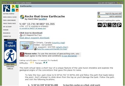
6 Earthcaching Example
7 Earthcaching History Earthcaching started as a pilot program early in Four initial caches were established in Colorado and two in Australia. Since then, participants have developed an additional 720 Earthcaches in 28 countries. Earthcaches are listed on the geocaching web site and through the portal. Earthcaches are a perfect way to take people to geological monuments, geologic type sections or just on self-guided field trips. They allow you to provide information for the general public without the cost or maintenance of interpretive signs. Earthcaches require no maintenance and can potentially exist forever once established. This fact, combined with the rapid growth of geocaching as an activity, will ensure the long-term impact of the project.
8 Who is Earthcaching for? The primary audience for Earthcaching is individuals and families who are already involved in geocaching, and the scienceinterested community. Because of the educational aspect of Earthcaching, schools will be able to use Earthcaches to assist them in leading field trips and to use GPS technology in the classroom and the field. Students may also be involved in geoscience research when developing their own Earthcaches.
9 Three Types of Earthcaches I. Teacher Created Earthcaches II. Earthcaches on Campus III. Student Created Earthcaches
10 Teacher Created Earthcaches Identify an Objective What Geography/Earth Science concept or system do you want to highlight? What other subject areas can be brought into the EarthCache? (mathematics, history, art..)
11 Teacher Created Earthcaches Develop Educational Goals Students will be able to Observe Measure Compare/contrast Produce Navigate Use technology
12 Teacher Created Earthcaches Identify a Location Does it meet your objective and goals? Can you get permission? National Park? Forest, state, county, private lands? Is it accessible? Is its safe? Cliffs, roads, railways, fences, stinging plants
13 Teacher Created Earthcaches Do the Research Educational notes will require some research Potential Sources Internet Library University Geological Survey Visitor Centers On site signage etc
14 Earthcaches on Campus What can you do when you can t leave campus? With GPS Unit Develop a Campus EarthCache Site Create a Cache Tour on Campus practice using GPS to find simple landmarks such as lampposts, playing fields, parking spaces, fence lines, etc. create a genuine EarthCache on campus not to be submitted Develop an EarthCaching Orienteering Tour Develop a Real EarthCache
15 Earthcaches on Campus What can you do when you can t leave campus? Without GPS unit Visit Existing EarthCache Sites Sample Lesson 1 - Erosion sites can be used to create printouts visit sites online using computer projector individual computer access by students sites assigned based on lesson objectives
16 Earthcaches on Campus What can you do when you can t leave campus? Without GPS unit Mapping Activities to Meet Standards research earthcache.org online or from printouts find latitude and longitude of various formations locate on map
17 Earthcaches on Campus What can you do when you can t leave campus? Without GPS unit Use EarthCache sites to study sort by classification choose U.S. and Canada glacial features mark and annotate on a map location time period research where icecaps are today and compare
18 Student Created Earthcaches Do you want students to create an EarthCache? Goals for students? - Teaching is the best way to learn * Creating an EarthCache is teaching someone about the earth science at that site - Research * Students must have the earth science knowledge in order to produce the educational notes for the EarthCache
19 Student Created Earthcaches Goals for students? - Determine what type of EarthCache Content Like the Rock and Sand Pit EarthCache Connected Links stops for learning like Work of Water Community Issues of concern erosion, landfill
20 Student Created Earthcaches Goals for students? - Following directions * Adhere and complete the EarthCache Submittal Guidelines (most rejections are because submissions are incomplete) - Assess * Students must come up with appropriate educational logging requirements! * They must make the test

21 Earthcaching onthe Red River
22 The Relationship Between Earthcaching and Constructivist Science Paradgims The paradigm shift from Earth Science to Geosciences is indicative of the inquiry based nature of science education. This shift includes project based learning, service learning, and most importantly, Process Oriented Guided Inquiry Learning or, POGIL.
23 Geosciences and The Red River Characteristics of the Red River Experience Culturally Relevant Real Life Holistic Cross Curricular
24 Development of the GLEs for this Lesson Use technology when appropriate to enhance laboratory investigations and presentations of findings (SI-H-A3) Interpret geological maps of Louisiana to describe the state s geologic history (ESS-H-C3) Determine the results of constructive and destructive forces upon landform development with the aid of geologic maps of Louisiana (ESS-M-A7) 20. Describe how humans actions and natural processes have modified coastal regions in Louisiana and other locations (ESS-M-A8)
25 Questions What activities changed the course of the Red River at the Grand Ecore? Why were the levees and revelles formed in the Red River/ What kinds of layers were formed in the banks of the Red River?
26 Instructional Strategies Cooperative Grouping Integrated Instruction Differentiated Instruction Process Oriented Guided Inquiry
27 Cooperative Group Jobs Photographer-Photograph the environment Cartographer-Draws maps of the location Geologist-locates and identifies rocks and rock bed formation. Reporter-Reports the findings and changes in the river course
28 Concepts The results of constructive and destructive forces on landform development Describe how humans actions and natural processes have modified coastal regions and other locations. Drawing topographic maps of landforms. Using the appropriate technology and equipment for studying geologic formations.
29 Project Structure Students will: Develop an earthcache including the geological and historical background of the development of the Grand Ecore and Red River river basin. Learners will describe the historical background of the Grand Ecore community.

30 Erosion of the Red River Banks Students will take pictures of the Red River course, levees, archived maps from the Army Corps of Engineers. Students who will be serving as cartographers will be drawing maps from the school site using GPS. Each reporter will develop a presentation which will be recorded and presented to each class.
31 Closure Earthcaching and POGIL are important instructional strategies for at risk students. All three sites for this activity are located in a small urban town with a geological landform located within four miles. This allows at risk learners to participate in an informal science experience.
EarthCaching FUNdamentals
 EarthCaching FUNdamentals by Wes Skinner (NorthWes) Anchorage, Wasilla, Central Kenai Peninsula, Valdez and Homer 15 April 2010 EarthCache Outline: EarthCaches vs Other Cache Types EarthCache Master Program
Your ALASKAN based Geocaching Organization Exploring Alaska One Cache at a Time
 Your ALASKAN based Geocaching Organization Exploring Alaska One Cache at a Time Please Join Us to Help Promote Geocaching in Alaska! Visit: GeocacheAlaska.ORG What We Do Promote Geocaching as an exciting,
Your ALASKAN based Geocaching Organization Exploring Alaska One Cache at a Time. What We Do. GeocacheAlaska! Inc. 20 March 2014
 Your ALASKAN based Geocaching Organization Exploring Alaska One Cache at a Time Please Join Us to Help Promote Geocaching in Alaska! Visit: GeocacheAlaska.ORG What We Do Promote Geocaching as an exciting,
MIDDLE SCHOOL CURRICULUM TR AILING ICE AGE M YST ERI E S SEARCHING GLACIAL FEATURES
 MIDDLE SCHOOL CURRICULUM TR AILING ICE AGE M YST ERI E S SEARCHING GLACIAL FEATURES CONTENTS I. Enduring Knowledge... 3 II. Teacher Background... 3 III. Before Viewing the Video... 5 IV. Viewing Guide...
MIDDLE SCHOOL CURRICULUM TR AILING ICE AGE M YST ERI E S ICE AGE TREKKING
 MIDDLE SCHOOL CURRICULUM TR AILING ICE AGE M YST ERI E S ICE AGE TREKKING CONTENTS I. Enduring Knowledge... 3 II. Teacher Background... 3 III. Before Viewing this Video... 5 IV. Viewing Guide... 5 V. Discussion
Teacher s Guide For. Glaciers
 Teacher s Guide For Glaciers For grade 7 - College Program produced by Centre Communications, Inc. for Ambrose Video Publishing, Inc. Executive Producer William V. Ambrose Teacher's Guide by Mark Reeder
Please make sure that all teachers and chaperones attending the field study are aware of the following information:
 Dear Teacher, Thank you for signing up for The Ice Age at the Lost Valley Visitor Center in Glacial Park. The visitor center is located in the middle of Glacial Park. Follow the signs from the Harts Road
INTERPRETING TOPOGRAPHIC MAPS (MODIFIED FOR ADEED)
") INTERPRETING TOPOGRAPHIC MAPS (MODIFIED FOR ADEED) Science Concept: Topographic maps give information about the forces that shape the features of Earth. Objectives: The student will: identify land features
INTERPRETING TOPOGRAPHIC MAPS (MODIFIED FOR ADEED) Science Concept: Topographic maps give information about the forces that shape the features of Earth. Objectives: The student will: identify land features
Mapping the Snout. Subjects. Skills. Materials
 Subjects Mapping the Snout science math physical education Skills measuring cooperative action inferring map reading data interpretation questioning Materials - rulers - Mapping the Snout outline map and
Job Description for Camp Administrators and Staff
 Job Description for Camp Administrators and Staff Position Title: Executive Camp Director The Executive Camp Director plans, coordinates, and oversees the overall camp program, approves all camp activities,
Aaron Marcus and Associates, Inc Euclid Avenue, Suite 1F Berkeley, CA , USA
 1196 Euclid Avenue, Suite 1F Berkeley, CA 94708-1640, USA Experience Design Intelligence User-Interface Development Information Visualization Email: Aaron.Marcus@AMandA.com Tel: +1-510-601-0994, Fax: +1-510-527-1994
Changing trends in UK tourism and the need to develop sustainable tourism
 WJEC PATHWAYS - ENTRY QUALIFICATIONS Title Changing trends in UK tourism and the need to develop sustainable tourism Unit Ref. No. Entry Code Level Entry 2 / 3 Credit Value 3 Unit aim This unit aims to
Lesson. Glaciers Carve the Land A QUICK LOOK. Overview. Big Idea. Process Skills Key Notes
 EARTH S CHANGING SURFACE CLUSTER 2 HOW THE EARTH S SURFACE CHANGES Lesson 62 Glaciers Carve the Land A QUICK LOOK Big Idea Moving water, ice, and wind break down rock, transport materials, and build up
Ouimet Canyon Provincial Nature Reserve. Management Plan
 Ouimet Canyon Provincial Nature Reserve Management Plan NOTE: This document has been scanned and formatted, and therefore is slightly different from the original version. -March 2002 Additional copies
KS3 KIDZANIA POST-VISIT LEARNING RESOURCES KIDZANIA POST-VISIT LESSON PLAN
 KS3 KIDZANIA POST-VISIT LEARNING RESOURCES KIDZANIA POST-VISIT LESSON PLAN KS3 KIDZANIA POST-VISIT LESSON PLAN ThIs lesson should be completed in the classroom after you visit KidZania. LEARNING OBJECTIVES
Arthur Carhart National Wilderness Training Center s Wilderness Investigations High School
 Arthur Carhart National Wilderness Training Center s Wilderness Investigations High School Wilderness 101/Lesson 7 Wilderness: Part of the American Commons Goal: Students will gain historical background
Lesson 1: Rolling and moving with Science
 Question: How is science related to roller coasters? Interpret and apply Newton's three laws of motion. Describe phase transitions in terms of kinetic molecular theory Lesson 1: Rolling and moving with
TRAIL MAPPING AND MARKING POLICY SANTA FE TRAIL ASSOCIATION Adopted by the Santa Fe Trail Association Board of Directors, April 13, 2002
 TRAIL MAPPING AND MARKING POLICY SANTA FE TRAIL ASSOCIATION Adopted by the Santa Fe Trail Association Board of Directors, April 13, 2002 INTRODUCTION There are three principle aspects to the marking of
Wilderness 101/Lesson 2 (OPTION 3) Introducing Wild, Wilderness and the Wilderness Act
 Introducing Wild, Wilderness and the Wilderness Act") Arthur Carhart National Wilderness Training Center s Wilderness Investigations High School Wilderness 101/Lesson 2 (OPTION 3) Introducing Wild, Wilderness and the Wilderness Act Goals: Explore: What is
Arthur Carhart National Wilderness Training Center s Wilderness Investigations High School Wilderness 101/Lesson 2 (OPTION 3) Introducing Wild, Wilderness and the Wilderness Act Goals: Explore: What is
MARINE PROTECTED AREAS LESSON PLAN Water Parks
 Marine Protected Areas U. S. Marine Protected Areas Lesson Plan MARINE PROTECTED AREAS LESSON PLAN Water Parks Theme U.S. Marine Protected Areas Links to Overview Essays and Resources Needed for Student
Preparatory Course in Business (RMIT) SIM Global Education. Bachelor of Applied Science (Aviation) (Top-Up) RMIT University, Australia
 SIM Global Education. Bachelor of Applied Science (Aviation) (Top-Up) RMIT University, Australia") Preparatory Course in Business (RMIT) SIM Global Education Bachelor of Applied Science (Aviation) (Top-Up) RMIT University, Australia Brief Outline of Modules (Updated 18 September 2018) BUS005 MANAGING
Preparatory Course in Business (RMIT) SIM Global Education Bachelor of Applied Science (Aviation) (Top-Up) RMIT University, Australia Brief Outline of Modules (Updated 18 September 2018) BUS005 MANAGING
University of Northern Iowa. SUMMER 2017 camps.uni.edu. University of Northern Iowa
 University of Northern Iowa SUMMER 2017 camps.uni.edu University of Northern Iowa Dear Campers (and parents), We invite you to participate in a UNI STEM Camp this summer. Science, technology, engineering,
T ourism. KS3 Geography. B B C Northern Ireland Education Online. Introduction. What is Education for Sustainable Development?
 Introduction The aim of this web site is to provide teachers with a means of delivering up to date material. using local examples. covering a wide range of geographical themes. integrating ICT with good
Board/Authority Authorized Course Framework Template
 Board/Authority Authorized Course Framework Template School District/Independent School Authority Name: Okanagan-Skaha School District 67 Developed by: Mike Barron School Name: Penticton Secondary Superintendent
1 INFORMATION REQUIREMENTS
 1 INFORMATION REQUIREMENTS 1.1 BACKGROUND 2 1.2 WHAT IS THE DISTRICT PLAN 3 1.3 DISTRICT PLAN STRUCTURE 4 1.4 HOW TO USE THE DISTRICT PLAN 5 1.5 STRATEGIC FRAMEWORK 6 Whanganui District Plan (15 January
Prerequisites: American Heritage / American Cultures:
 Prerequisites: American Heritage / American Cultures: Item 3 C: Research your family's history. Find out how various events & situations in American history affected your family If your family immigrated
Arthur Carhart National Wilderness Training Center s Wilderness Investigations High School
 Arthur Carhart National Training Center s Investigations High School 101/Lesson 2 (OPTION 2B) Introducing the Act Goal: Students will understand the difference between wild spaces and federally designated
Geocaching Activity Plan
 Geocaching Activity Plan CONTENTS Outcomes... 2 Activity... 2 2.1 Outline... 2 2.2 Equipment... 2 2.3 Communication... 3 2.4 First Aid... 3 People... 3 3.1 Activity Instructor... 3 3.2 School Staff Member
Oak Ridges Moraine: Southern Ontario's Sponge
 Oak Ridges Moraine: Southern Ontario's Sponge Lesson Overview Students will examine the location and the importance of the Oak Ridges Moraine and investigate ongoing conflicts concerning its development.
The Atlas of Hillforts of Britain and Ireland. Hillfort survey notes for guidance
 The Atlas of Hillforts of Britain and Ireland Hillfort survey notes for guidance The collection of surveys for the Atlas is now finished but you can use this form and the accompanying Notes for Guidance
BSc (Hons) Food Science and Technology (Minor: Food Microbiology) (Full-Time)
 Food Science and Technology (Minor: Food Microbiology) (Full-Time)") BSc (Hons) Food Science and Technology (Minor: Food Microbiology) (Full-Time) 1. Objectives The programme is designed to develop the necessary attitude and competence for the application of scientific
BSc (Hons) Food Science and Technology (Minor: Food Microbiology) (Full-Time) 1. Objectives The programme is designed to develop the necessary attitude and competence for the application of scientific
Loop Walks Key Criteria
 Loop Walks Key Criteria 1/31/2012 CONTENTS Mission... 3 Background... 3 Phase 1... 3 Guidelines... 3 Occasional Walker... 5 Level of Difficulty... 5 Loop Furniture... 6 1. Mapboard... 6 2. Waymarkers...
26 Utah s Patchwork Parkway SCENIC BYWAY CORRIDOR MANAGEMENT PLAN (SR 143)
") Natural Natural Quality applies to those features in the visual environment that are in a relatively undisturbed state. These features predate the arrival of human populations and may include geological
Natural Natural Quality applies to those features in the visual environment that are in a relatively undisturbed state. These features predate the arrival of human populations and may include geological
How Interpretive Geocaching Links Partners and Delivers Visitors to National Historic Trails. SORP Conference April 14, 2015
 Partners and Delivers Visitors to National SORP Conference April 14, 2015 What is Geocaching? Someone hides a container -- the cache -- and posts data about it to www.geocaching.com What is Geocaching?
SAULT COLLEGE SAULT STE. MARIE, ONTARIO COURSE OUTLINE
 SAULT COLLEGE SAULT STE. MARIE, ONTARIO COURSE OUTLINE COURSE TITLE: Trail Construction and Facility Maintenance CODE NO. : NRT 260 SEMESTER: 3 PROGRAM: AUTHOR: Adventure Recreation and Parks Brian Anstess
Kindergarten Science Unit C: Earth Science Chapter 5: Our Land, Air, and Water Lesson 1: What makes up the Earth?
 Insert Photo or Graphic for Unit or Lesson Theme Kindergarten Science Unit C: Earth Science Chapter 5: Our Land, Air, and Water Lesson 1: What makes up the Earth? Insert Photo/Graphic Earth Insert Photo/Graphic
Manitoba Technical-Vocational Curriculum Framework of Outcomes. Grades 9 to 11 Pilot Ground School 2018 Draft
 Manitoba Technical-Vocational Curriculum Framework of Outcomes Grades 9 to 11 Pilot Ground School 2018 Draft Goal 1: Describe and apply appropriate health and safety practices. GLO 1.1: Describe and apply
Advancing FTD technologies and the opportunity to the pilot training journey. L3 Proprietary
 Advancing FTD technologies and the opportunity to the pilot training journey L3 Proprietary Aviation Training Innovation Over the past decade the airline training industry has pursued technology to improve
Amusement Park Physics 11 Answers
 We have made it easy for you to find a PDF Ebooks without any digging. And by having access to our ebooks online or by storing it on your computer, you have convenient answers with amusement park physics
Outdoor Education. Camp Whitcomb- Mason. October 1 & 2 Guided Study Groups: Kopplin, Zurbuchen, Ross, Hopgood (Title1 TBD) October 3 & 4
 October 3 & 4") Outdoor Education Camp Whitcomb- Mason October 1 & 2 Guided Study Groups: Kopplin, Zurbuchen, Ross, Hopgood (Title1 TBD) October 3 & 4 Guided Study Groups: Perry, Susedik (Title2 TBD), Gitter, Borkowski
Outdoor Education Camp Whitcomb- Mason October 1 & 2 Guided Study Groups: Kopplin, Zurbuchen, Ross, Hopgood (Title1 TBD) October 3 & 4 Guided Study Groups: Perry, Susedik (Title2 TBD), Gitter, Borkowski
Geocaching Merit Badge
 Geocaching Merit Badge 1 The Plan for Today What is Geocaching? Safety How to Find a Geocache Mapping: GPS, UTM, Compass How to Hide a Geocache Geocaching Terms CITO Leave no Trace Geocaching Game 2 What
PCBS DELINEATION WORK PLAN
 PCBS DELINEATION WORK PLAN BLUE ISLAND NORTHEAST MIXED-USE COMMERCIAL PARK (FORMER BLUE ISLAND LANDFILL) BLUE ISLAND, COOK COUNTY, ILLINOIS PREPARED FOR: CITY OF BLUE ISLAND 13051 SOUTH GREENWOOD AVENUE
The Geological Pacific Northwest. Wednesday February 6, 2012 Pacific Northwest History Mr. Rice
 The Geological Pacific Northwest Wednesday February 6, 2012 Pacific Northwest History Mr. Rice 1 Free Response #2 Please do not simply list the items for this response. Full sentences!!! Minimum of 3-5
Descent into the Ice PROGRAM OVERVIEW
 PROGRAM OVERVIEW NOVA follows glaciologists into the underworld of Mont Blanc, where they search for internal lakes. The program: revisits the 1892 disaster in which a hidden lake burst forth from a glacier
Menlo Park Fire District Training Division. Unmanned Aerial System Pilot
 Menlo Park Fire District Training Division TASK BOOK FOR THE POSITION OF Unmanned Aerial System Pilot Date Issued TASK BOOK ASSIGNED TO: Individuals name, assignment DATE TASK BOOK INITIATED The material
2.08 AVALANCHE SEARCH AND RESCUE. Q: What is the process to provide feedback on the Interim Policy and Avalanche Safety Plan?
 2.08.1 RELATED DOCUMENTS 2.08 Avalanche Search and Rescue Policy 2.08 AVALANCHE SEARCH AND RESCUE 2.08.2 FREQUENTLY ASKED QUESTIONS AVALANCHE SAFETY PLANNING Q: Are SAR Groups required to develop their
PhD (Hotel & Tourism Management)/URS Jan,17 to Dec, 17 Scheme of Examinations. Paper Name of paper Written Workshop of Assignments Total
/URS Jan,17 to Dec, 17 Scheme of Examinations. Paper Name of paper Written Workshop of Assignments Total") PhD (Hotel & Tourism Management)/URS Jan,17 to Dec, 17 Scheme of Examinations Paper Name of paper Written Workshop of Assignments Total Examination published work 17 HTMPC1 Methodology for 50 50-100 Hospitality
PhD (Hotel & Tourism Management)/URS Jan,17 to Dec, 17 Scheme of Examinations Paper Name of paper Written Workshop of Assignments Total Examination published work 17 HTMPC1 Methodology for 50 50-100 Hospitality
Rationale or Purpose: This lesson will demonstrate several properties of water and bring awareness of what global warming may do to the sea level.
 Title: Glaciers and Icebergs Grade Level: 5th Objectives: Students will be able to: Identify the differences and similarities between a glacier and an iceberg; Recall the density of water and ice; Observe
Sterile Technique TEACHER S MANUAL AND STUDENT GUIDE
 Sterile Technique TEACHER S MANUAL AND STUDENT GUIDE Table of Contents TEACHER S MANUAL Overview....3 Objectives............................................................. 3 Correlation to Science Standards...3
Coral Reefs: Integrative Teaching Tool (and Guide to NOAA Resources) National Science Teachers Association April 6, 2006 Anaheim, California
 National Science Teachers Association April 6, 2006 Anaheim, California") Coral Reefs: Integrative Teaching Tool (and Guide to NOAA Resources) National Science Teachers Association April 6, 2006 Anaheim, California NOAA Coral Reef Conservation Program: Created by NOAA in 2000
Coral Reefs: Integrative Teaching Tool (and Guide to NOAA Resources) National Science Teachers Association April 6, 2006 Anaheim, California NOAA Coral Reef Conservation Program: Created by NOAA in 2000
Curriculum Guide. Mathcad Prime 4.0
 Curriculum Guide Mathcad Prime 4.0 Live Classroom Curriculum Guide Mathcad Prime 4.0 Essentials Mathcad Prime 4.0 Essentials Overview Course Code Course Length TRN-5140-T 16 Hours In this course, you will
GRADE 1 SUPPLEMENT. Set C2 Geometry: Ladybug & Butterfly Calendar Pattern. Includes. Skills & Concepts. October Calendar Pattern C2.
 GRADE 1 SUPPLEMENT Set C2 Geometry: Ladybug & Butterfly Calendar Pattern Includes October Calendar Pattern C2.1 Skills & Concepts H demonstrate an understanding of position words, including above/below,
Location and transportation: Dates: Sunday, May 31 Monday, August 10 Age requirements: Covenant:
 Thank you for expressing interest in serving with the College Program at Ghost Ranch Education & Retreat Center. Ghost Ranch is a national Conference Center of the Presbyterian Church (USA), located in
OCEANIC REQUIRED NAVIGATION PERFORMANCE (Including RNP-10 and RNP-4)
") King Schools Online Internet Learning Programs OCEANIC REQUIRED NAVIGATION PERFORMANCE (Including RNP-10 and RNP-4) Flight Crew Certification Course SYLLABUS King Schools, Inc. 3840 Calle Fortunada San
King Schools Online Internet Learning Programs OCEANIC REQUIRED NAVIGATION PERFORMANCE (Including RNP-10 and RNP-4) Flight Crew Certification Course SYLLABUS King Schools, Inc. 3840 Calle Fortunada San
The Case of the Stolen CD Players
 Detective Curious got a lead on some missing compact CD players she was investigating. The informer hinted that the stolen CD players (and maybe even the culprit) could be found in an abandoned warehouse
Lidar Imagery Reveals Maine's Land Surface in Unprecedented Detail
 Maine Geologic Facts and Localities December, 2011 Lidar Imagery Reveals Maine's Land Surface in Unprecedented Detail Text by Woodrow Thompson, Department of Agriculture, Conservation & Forestry 1 Introduction
Aboriginal and Torres Strait Islander education ACARA syllabuses and new opportunities
 Aboriginal and Torres Strait Islander education ACARA syllabuses and new opportunities Shirley Gilbert University of Western Sydney Hawkesbury Discovery Centre UWS Hawkesbury campus 13 th November 2014
Committee. Presentation Outline
 CW-33-15 11/9/2015 Community and Corporate Services Committee November 10, 2015 1 Presentation Outline Background Vision and Objectives Study Process and Timeline Public and Stakeholder Engagement Organization
3-D GIS Applications in Aviation and Aerospace Pedagogy Dr. Rich Snow, Dr. Mary Snow, and Mario Westphal. Abstract
 3-D GIS Applications in Aviation and Aerospace Pedagogy Dr. Rich Snow, Dr. Mary Snow, and Mario Westphal Abstract Embry-Riddle Aeronautical University s new GIS Applications Lab has developed a 3-D airspace
KS2 KIDZANIA PRE-VISIT LEARNING RESOURCES KIDZANIA PRE-VISIT LESSON PLAN
 KS2 KIDZANIA PRE-VISIT LEARNING RESOURCES KIDZANIA PRE-VISIT LESSON PLAN KS2 KIDZANIA PRE-VISIT LESSON PLAN These activities should be carried out before the visit to KidZania in your classroom. LEARNING
Victorian Bushfires Surveying Taskforce
 Victorian Bushfires Surveying Taskforce Surveying Response to the Victorian Bushfires of February 2009 XXIV Sydney, Australia, 11-16 April 2010 Presented by: Eddie Cichocki Australia Introduction The State
PBN/TF/7 DRAFT Appendix D to the Report D-1
 DRAFT STATUS OF IMPLEMENTATION TASKS LIST PBN Task Force C4/1 The APAC PBN TF encourages States to consider the GO Team visit. On-going. States are encouraged to consider the GO Team visit as required.
SUMMER 2018 JOB DESCRIPTIONS
 SUMMER 2018 JOB DESCRIPTIONS Lenape Day Camp Camp Director Full-Day seasonal position (8:15 am 3:30 pm) for the eight-week summer season (6/25/18-8/17/18) and additional hours as needed. The Camp Director
What do children learn when camping?
 What do children learn when camping? Perceptions of parents and children April 2015 Sue Waite, Gemma Parkinson, Dominic Martignetti & Dr Rana Moyeed How we did the research An electronic survey Do you
Unit 1-Understanding Travel and Tourism Lesson#1
 Focus Questions Unit 1-Understanding Travel and Tourism Lesson#1 What is travel and tourism? Why do people travel? What are some issues that arise from the desire of people for travel experiences? What
The Summits of Canada Expedition Information and Education Summary
 The Summits of Expedition Information and Education Summary A historic Canadian adventure, the Summits of Expedition, will take place in 2006 to put the first Canadian Team on the highest point of s thirteen
Exemplar for Internal Achievement Standard Geography Level 1. Conduct geographic research, with direction
 Exemplar for internal assessment resource Geography for Achievement Standard 91011 Exemplar for Internal Achievement Standard Geography Level 1 This exemplar supports assessment against: Achievement Standard
GC 225 Lecture Exam #2
 GC 225 Lecture Exam #2 Direction- path along which something is moving. 3 Types; - COMPASS DIRECTIONAL NAME (32 in total) - BEARING (four 0 o - 90 o ) - AZIMUTHS (0 o - 360 o ) Compass (32 named points)
Learning to Rockhampton Aero Club
 Learning to Fly @ Rockhampton Aero Club The Rockhampton Aero Club is one of the oldest flying clubs in Australia Established in 1930 A BRIEF HISTORY First formed in 1930 as Rockhampton Aerial Services,
Stainless Steel for Industrial Design Seminar
 Stainless Steel for Industrial Design Seminar WHAT IS IMINOX? The Mexican Institute of Stainless, IMINOX, is a private non-profit association formed by a group of comapnies that prodeuce, distribute and
The Palmetto Trail: Linking the Mountains to the Sea
 The Palmetto Trail: Linking the Mountains to the Sea Jana Locklair Pine Ridge Middle School jlock794@aol.com Overview Students will be given the opportunity to become familiar with the landform regions
GR. 2 WILD ABOUT WINTER TEACHERS PACKAGE. Bringing Winter to your Classroom
 GR. 2 WILD ABOUT WINTER TEACHERS PACKAGE Bringing Winter to your Classroom Introduction. Program at a Glance. Program Outlines. Grade 1 Curriculum Topics Specific Learner Expectations. Cross-Curricular
Activity: Global Tourism
 ACTIVITY 26: GLOBAL TOURISM 1 CGG3O Travel & Tourism Name: Oxford Canadian School Atlas 9 th edition On the Road Again Activity: Global Tourism How many times have you been watching television, reading
Table of Contents. Aviation Flight... 1 Aviation Flight Courses... 2 Aviation Flight Faculty... 4
 Table of Contents Aviation Flight... 1 Aviation Flight Courses... 2 Aviation Flight Faculty... 4 Aviation Flight The Aviation Flight program is designed to prepare beginning students for the Federal Aviation
Peter Axelson. Beneficial Designs, Inc. Minden, NV
 Peter Axelson Beneficial Designs, Inc. Minden, NV Arroya Sit Ski Mono Ski Dynamic Seating Spring Assist Cross Country Ski Hand Bike Adaptive Canoe Seating Available from Chosen Valley Canoe Accessories
MISSISSIPPI RIVER VISITOR CENTER
 MISSISSIPPI RIVER VISITOR CENTER Program Guide Page 2 Visiting Us? While visiting our facility your group can experience navigation up close! We offer the best view of the mighty Mississippi River and
Geocaching at the Klondike 2014
 Geocaching at the Klondike 2014 What is a Geocache? What do they typically look like? What is Geocaching? What is a GPS? How does a GPS work? What does Geocaching have to do with scouting? How many geocaches
Great Science Adventures
 Great Science Adventures Lesson 18 How do glaciers affect the land? Lithosphere Concepts: There are two kinds of glaciers: valley glaciers which form in high mountain valleys, and continental glaciers
Give Lift to Your CTE Program Through Aviation
 Give Lift to Your CTE Program Through Aviation Cindy Hasselbring Sr. Director, High School Aviation Initiative, AOPA Pat Cwayna CEO, West Michigan Aviation Academy Dave Sebuck Dean, Aviation, West Michigan
1. Name: Dr Ravindra K Pande. 2. Designation: Professor of Geography. 5. Research field: Geomorphology, Disaster Management, RS & GIS
 ACADEMIC PROFILE 1. Name: Dr Ravindra K Pande 2. Designation: Professor of Geography 3. Experience: About 38 years 4. Qualification: PhD 5. Research field: Geomorphology, Disaster Management, RS & GIS
THE IMPLEMENTATION OF EWFD/WFD IN THE REGION OF VOJVODINA WITHIN JOINT SLOVAK-SERBIA SERBIA PROJECTS
 Towards Integrated River Basin Management The 55 th Anniversary of the Founding of the Water Research Institute THE IMPLEMENTATION OF EWFD/WFD IN THE REGION OF VOJVODINA WITHIN JOINT SLOVAK-SERBIA SERBIA
Inuksuk: Thing That Can Act in the Place of a Human Being
 Inuksuk: Thing That Can Act in the Place of a Human Being Developed by: Jen Reiter, 2014 Iditarod Teacher on the Trail, created May, 2017 Discipline / Subject: Reading, Tech Integration Topic: Reading
Introduction & Admin. Online UAS Training Courses. Virtual Meet & Greet
 Introduction & Admin Online UAS Training Courses Virtual Meet & Greet Introduction Aim 1. Organise your thoughts - Overview of the Course Material - A framework for developing Expertise. 2. Get started
GROUND HANDLING COURSES Amadeus Customer Service
 GROUND HANDLING COURSES Amadeus Customer Service 30 April 2018 SUMMARY Altéa Administration for Ground Handlers... 3 Amadeus Altea document management for Altea Departure Control... 4 Amadeus Security
TERMS OF REFERENCE INDIVIDUAL CONSULTANT(S)
") TERMS OF REFERENCE INDIVIDUAL CONSULTANT(S) Assignment: Organization: Detailed Damage Assessment of the Cultural Heritage Sites and Historical Buildings in Tongatapu Island following Tropical Cyclone Gita
TERMS OF REFERENCE INDIVIDUAL CONSULTANT(S) Assignment: Organization: Detailed Damage Assessment of the Cultural Heritage Sites and Historical Buildings in Tongatapu Island following Tropical Cyclone Gita
Buffalo Pound Provincial Park
 Pound Park Pound Park Pound Park Pound Park 2019 2019 Bring your class to our outdoor 2019 school programs are Bring yourguided class to our outdoor offered in theto spring at Pound are Guided school programs
CENTRAL TEXAS COLLEGE AIR AGENCY No. DU8S099Q SYLLABUS FOR AIRP 2337 COMMERCIAL GROUND SCHOOL Semester Hours Credit: 3. Instructor: Office Hours:
 CENTRAL TEXAS COLLEGE AIR AGENCY No. DU8S099Q SYLLABUS FOR AIRP 2337 COMMERCIAL GROUND SCHOOL Semester Hours Credit: 3 Instructor: Office Hours: I. INTRODUCTION A. The training course outline meets all
Northern Rockies District Value of Tourism Research Project December 2007
 Northern Rockies District Value of Tourism Research Project December 2007 Project Partners: Northern Rockies Regional District, Tourism British Columbia, Northern Rockies Alaska Highway Tourism Association,
ABSTRACT TIES TO CURRICULUM TIME REQUIREMENT
 ABSTRACT This lesson uses the thrill of amusement park attractions to teach students how to analyze principles of motion. The Calculator Based Laboratory helps students record and analyze acceleration
Private Pilot License Outline
 Private Pilot License Outline Welcome to Principal Air and congratulations on taking the first step towards an exciting lifestyle. Few qualifications can match the challenge, opportunity and satisfaction
Why McMurray Aviation?
 Flight Training Why McMurray Aviation? McMurray Aviation provides a flight training program to meet your needs. Over the past years we have developed a reputation for offering quality instruction, a friendly
THE TANZANIAN SEA LEVEL NETWORK: A NATIONAL REPORT (DRAFT)
") THE TANZANIAN SEA LEVEL NETWORK: A NATIONAL REPORT (DRAFT) Shigalla B. Mahongo Tanzania Fisheries Research Institute P.O. Box 9750, Dar es Salaam, Tanzania [Tel: +255 51 650045; Fax: +255 51 650043; Email:
THE TANZANIAN SEA LEVEL NETWORK: A NATIONAL REPORT (DRAFT) Shigalla B. Mahongo Tanzania Fisheries Research Institute P.O. Box 9750, Dar es Salaam, Tanzania [Tel: +255 51 650045; Fax: +255 51 650043; Email:
AERONAUTICS An Educator s Guide with Activities in Science, Mathematics, and Technology Education National Aeronautics and Space Administration
 AERONAUTICS An Educator s Guide with Activities in Science, Mathematics, and Technology Education National Aeronautics and Space Administration Objective The students will: Learn how to change the flight
Accept, Sir/Madam, the assurances of my highest consideration.
 Tel.: +1 514-954-8219 ext. 6107 Ref.: SP 73/1 IND/15/7 6 March 2015 Subject: Invitation to the First Meeting of the Meteorology Panel (METP/1), to be held from 20 to 24 April 2015 Action Required: Confirm
APLU Annual Meeting Austin, Texas
 National Aeronautics and Space Administration Parimal Kopardekar, Ph.D. NASA Senior Technologist for Air Transportation System, and Principal Investigator for UTM APLU Annual Meeting Austin, Texas 1 Excited
Kit Carson-Challenger Ridge Trail Project
 Kit Carson-Challenger Ridge Trail Project Project Accomplishments Report-USFS December 15, 2015 Photo courtesy of Justin Peterson 815 South 25 th Street, Suite 101 Colorado Springs, CO 80904 Dedicated
A GUIDE TO MANITOBA PROTECTED AREAS & LANDS PROTECTION
 A GUIDE TO MANITOBA PROTECTED AREAS & LANDS PROTECTION Manitoba Wildands December 2008 Discussions about the establishment of protected lands need to be clear about the definition of protection. We will
VERP Assignment for Ft. Fisher State Recreation Area
 Case Background VERP Assignment for Ft. Fisher State Recreation Area Fort Fisher State Recreation Area is a jewel of the southeastern coast of North Carolina. Comprised of a wide variety of maritime ecosystems,
e 2 design season three New Orleans: The Water Line Episode Summary
 e 2 design season three New Orleans: The Water Line Episode Summary After the devastation of Hurricane Katrina, which hit the southern coast of the United States on August 28, 2005, the residents of the
Flight Academy Australia Training and Assessment Strategy AVI50415 Diploma of Aviation (Instrument Rating)
") Purpose of a training and assessment strategy This training and assessment strategy is used to advise third parties of the structure our course delivery and assessment. It is a document that specifies
Purpose of a training and assessment strategy This training and assessment strategy is used to advise third parties of the structure our course delivery and assessment. It is a document that specifies