Explore the Bay the Green Way
|
|
|
- Maria Maxwell
- 5 years ago
- Views:
Transcription
1 Explore the Bay the Green Way Botany Bay Trail Pre-Feasibility Study Report Nick Benson Sutherland Shire Environment Centre August
2 Botany Bay Trail Explore the Bay the Green Way Opportunities for Bayside Businesses The following is a presentation given on the 7 September 2002 to the Community Trails Public Forum. It examines the potential for a shared use multipurpose recreational trail foreshores of Botany Bay from historic Kurnell around to La Perouse. The trail offers tremendous opportunities for businesses to partner with the community and not just as a sponsor. Opportunities: To be actively involved in programmes to rehabilitate stretches of the foreshore focussed around trail development. To get your message across, promote your own environmental programmes to the wider community, and be a good neighbour. To tell your story about your relationship with the Bay. Initially sponsorship is needed to complete a comprehensive feasibility study which assesses engineering solutions to key challenges along the route.
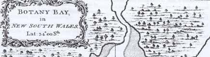
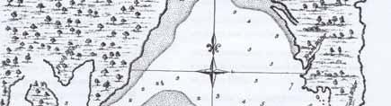
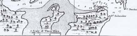
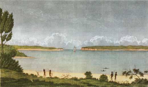
3 The traditional owners, the first map and the Botany Bay Trail Concept c. 1812
4 Background Objectives Approach Findings Tour of the Bay The Next Stage


5 Background Botany Bay is unique in character Rich Aboriginal and European history, cultural diversity of its people, wide open spaces and vistas, a variety of wildlife habitats, and a wealth of heritage it holds a special place in the hearts of locals and visitors alike. Despite the massive presence of industry, it still manages to inspire the imagination and a trail will enable everyone to explore this special Bay, to raise awareness of its environmental state both good and bad, and help promote a better sense of belonging to country. On which other trail can you see your destination - so tantalisingly close - before you embark on the adventure? La Perouse Kurnell Parts of the trail will be suitable for all, including wheelchair users, whilst others will be appropriate for walkers only with alternative routes for cyclists. 5
6 Background recommendation of the Tide is Turning, Final Report of The Botany Bay Program opportunity to bring community and government together a la San Francisco Bay Trail population of more than 1 million accessing land & water based recreation in the Bay public access exists in many places, but no plan for a continuous system SSROC is a readymade focus for initial work supported by SSEC and SSC 6
7 Objectives identify an in principle route and test its potential for gradual implementation divide the route into sectors apply the trail concept to each sector opportunities & existing infrastructure constraints & barriers to movement suggest future detailed studies planning, design, costing, implementation recommend priorities for action 7
8 Approach Search for possible routes for a trail liaison with key landholders and developers: Sydney Airport Sydney Ports Corporation South Sydney Development Corporation Sydney Harbour Foreshores Authority help in form of maps, air photos, technical reports accurately identify existing infrastructure & landward boundaries of their sites 8
9 Approach liaison with Councils and Government: all Bayside SSROC Councils National Parks & Wildlife Service Roads & Traffic Authority obtain reaction to trail concept info on existing trail elements their thoughts on problem areas & constraints ongoing walk/cycle path projects which could form part of ultimate network 9
10 Approach community and user group consultation: La Perouse people BicycleNSW Botany Environment Watch Botany Bay and Catchment Alliance Kurnell Regional Environment Planning Council Rockdale Wetlands Society Taren Point Wetlands Group obtain reaction to trail proposal issues and concerns raised opportunities for future participation 10
11 Approach a general picture of land ownership pattern along the foreshore: commonwealth, state, council, private, institutional mapping of overall route and individual sectors trail design tentative suggestions for engineering solutions, drainage, surfacing, signage, access field inspections brief discussion of links to other existing and proposed trails Woronora, Georges River, Cooks River etc.. 11
12 Explore the Bay the Green Way A potential multi-access trail circling the bay Walking Track 45km Marton Park to Cape Banks Bicycle network 39km Cape Solander to La Perouse
13 13


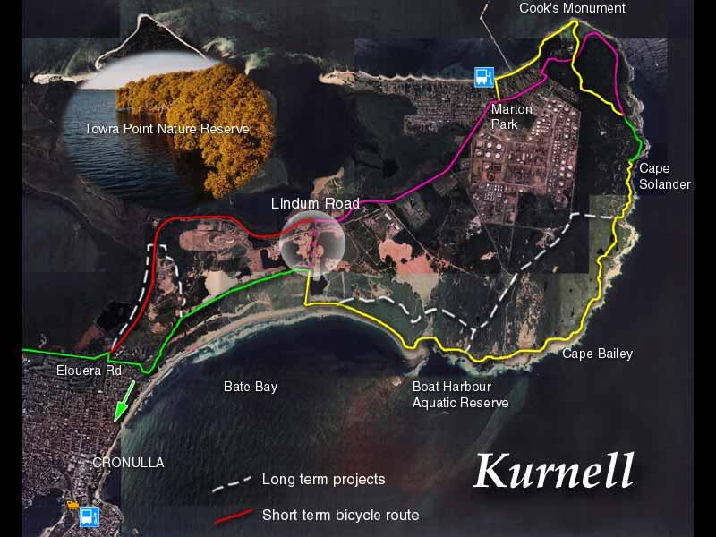
14 Kurnell Boardwalk construction at Silver Beach near Cooks Monument Sutherland Point Cape Solander 14


15 Kurnell South Boat Harbour humpies conflict of interest 4WD access to beach 15


")

16 Kurnell West existing track next to sandhill and pond - H6 site (Australand) heading for Cronulla sweep of the Bate Bay 16
17 17
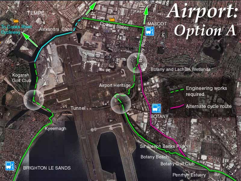
18 18


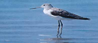
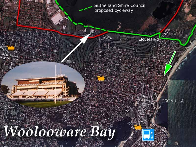
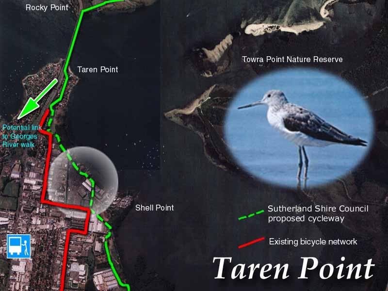
19 Woolooware Bay & Taren Point first stage of SSC cycleway part of 4 stage proposal 3.5km from Shark Park to Taren Point Bridge way is blocked at Shell Point complex land ownership illegal dredging and marinas impact on RAMSAR listed wetland Terek Sandpiper under threat trail will draw attention to issues 19
20 20
21 2 1

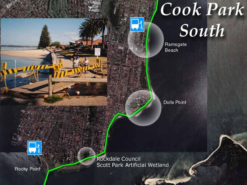
22 Cook Park Rockdale 22
23 23


24 Existing no provision for pedestrian access through tunnel - cycle access unsafe misleading sign at O Dea Ave Kyeemagh points to tunnel 24
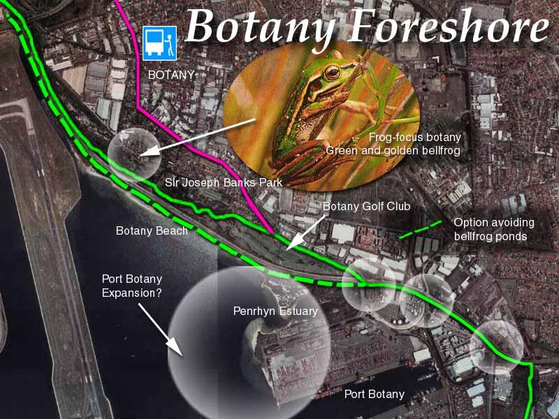
25 2


26 Option A - West Route goes under M5 & hugs west boundary of airport (east bank of Cooks River) avoiding Cooks Cove development site & Rockdale Wetlands 26


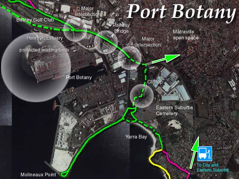
27 Option A - NW RTA route opposite Tempe Reserve (open) Alexandra Canal path (under construction) Coward Street pathway upgrade 27


28 Option A - SE inside old pumping station & mill tunnel required under GHD to Foreshore Park Engine Pond & dam Footbridge needed to cross GHD and join Ross Smith Ave 28
29 29
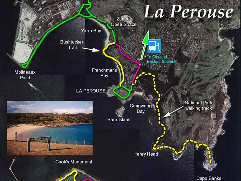
30 30
31 3 1
32 3


33 Botany Foreshore existing walk through Sir Joseph Banks Park - Foreshore Road to right and beach beyond. Botany Beach - potential alternative option for trail route between Road and Beach. Desirable to create safe public access via bridge over Foreshore Road connecting Park to Beach. cantilevered parapet needed to link Botany Beach and tunnel 33
34 34


35 Port Botany Port entrance intersection conflict solution could be translucent tube across from Botany gateway and edge of golf course Penrhyn Estuary - valuable shore bird habitat - A trail on estuary side (hatched green line) would add to disturbance of birds. NB If port expansion goes ahead, opportunity to incorporate purpose built shared use route in plans. suggest using cantilever solution to extend width of pathway over port goods railway line 35


36 Port Botany Old railway tracks alongside Botany Road - potential base for track cliff top route on Cemetery Trust land overlooking new customs facility crossing military Road to gap alongside Eastern Suburbs Cemetery 36
37 37


38 La Perouse - Yarra Bay Molineaux Point from Bumborah Reserve - 3km round trip recreation reserve - tip to be moved de facto access exists through to Bicentennial Park and sailing club 38


39 La Perouse - Frenchmans Land under the stewardship of local Aboriginal people in Frenchmans Bay not appropriate for cycleway Opportunity to incorporate Bush Tucker Trail around Yarra Bay House in the Green Way Anzac Parade Loop Randwick Council Project to make loop one way would free up a space for public pathway around the outside, providing safe access to visitor attractions 39


40 Journeys end or beginning... there is the extra 3km walk to Cape Banks or turn round and back to Kurnell in time for tea! 40
41 The Next Stage Recommendations: That a Steering Group be formed of key trail advocates to advance the proposal with the goal of having an in principle route alignment incorporated in all Bayside Local Environmental Plans, Master Plans and Corporate Plans. Begin concerted efforts to access funds to carry out detailed feasibility study to include work by the UNSW Botany Bay Science Unit on engineering solutions for the Trail with the emphasis on using sustainable materials where possible. Explore opportunities to partner with major employers. Organise a Bay Walk and invite Politicians and community and business leaders as well as local people to come and explore their much neglected yet special Bay 41
RE: Victoria Road upgrade (RTA December 2007). Thank you for the briefing from your department and the invitation to comment on the above.
. Thank you for the briefing from your department and the invitation to comment on the above.") Iain Macleod Project Manager Victoria Road upgrade Roads and Traffic Authority PO Box 743 Drummoyne NSW 1470 e : Victoria_Road_Info@rta.nsw.gov.au 21 February 2008 RE: Victoria Road upgrade (RTA December
Iain Macleod Project Manager Victoria Road upgrade Roads and Traffic Authority PO Box 743 Drummoyne NSW 1470 e : Victoria_Road_Info@rta.nsw.gov.au 21 February 2008 RE: Victoria Road upgrade (RTA December
Department of Environment, Climate Change & Water NSW. Stakeholder feedback
 Department of Environment, Climate Change & Water NSW Stakeholder feedback 1 Stakeholders group Blue Gum High Forest Group Guardians of Lane Cove NP Sydney Metropolitan Wildlife Service Ku-ring-gai Historical
Auburn Trail / Ontario Pathways Trail Connector Feasibility Study Public Information Meeting Wednesday, August 22, 2012
 Auburn Trail / Ontario Pathways Trail Connector Feasibility Study Public Information Meeting Wednesday, August 22, 2012 Purpose of Feasibility Study Purpose Evaluate the feasibility of constructing a multiuse
Central District CENTRAL
 C E N T R A L Central District District Suburbs Strategic Centre District Centre District Boundary Central Local Government Boundary Airport Waterways National Parks and Reserves Suburb name and boundary
The Vision for the San Juan Islands Scenic Byway
 The Vision for the San Juan Islands Scenic Byway 2 Judd Cove, Orcas Island, Courtesy of Kurt Thorson (kurtthorson.com) and San Juan County Land Bank Vision for the San Juan Islands Scenic Byway The San
Kilometres. Blacktown. Penrith. Parramatta. Liverpool Bankstown. Campbelltown
 0 5 10 15 20 Kilometres Penrith Blacktown Parramatta Liverpool Bankstown Campbelltown accessibility outcomes Legend Outcomes targeted in Western Sydney are: public transport that is accessible throughout
Appendix 3-B. Phase 2 - Recent Consultation
 Appendix 3-B Phase 2 - Recent Consultation PRE COMMONWEALTH EIS PUBLIC COMMENT PERIOD 19 23 March Gladstone s and tour Positive comments on the good level of engagement for the Project Percentage of bauxite
Abbey Chesterton bridge Questions & Answers
 Abbey Chesterton bridge Questions & Answers Please click on links below to go to individual subjects: Bridge location and access routes Timescales Bridge details and accessibility Construction compound
Proposal to Redevelop Lower Kananaskis River-Barrier Lake. Bow Valley Provincial Park. Frequently Asked Questions
 Proposal to Redevelop Lower Kananaskis River-Barrier Lake Bow Valley Provincial Park Frequently Asked Questions What is being proposed? What are the details of the proposal? Where is the project area located?
Macleod Trail Corridor Study. Welcome. Macleod Trail Corridor Study Open House. Presentation of Proposed Design Concepts
 Macleod Trail Corridor Study Welcome Macleod Trail Corridor Study Open House Presentation of Proposed Design Concepts Study Purpose Develop a corridor plan for Macleod Trail that aligns with The City s:
Report to: Greater Cambridge Partnership Joint Assembly 18 January A10 Foxton level crossing bypass and travel hub
 Report to: Greater Cambridge Partnership Joint Assembly 18 January 2018 Lead officer: Chris Tunstall GCP Director of Transport A10 Foxton level crossing bypass and travel hub 1. Purpose 1.1 The list of
Memo. Orange City Trail Plan Becky Mendez, AICP Jamie Krzeminski, PE, PTOE Matt Wiesenfeld, PE, AICP. Development of the Existing and Proposed Network
 Memo Date: Friday, December 22, 2017 Project: To: From: Subject: Trail Plan Becky Mendez, AICP Jamie Krzeminski, PE, PTOE Matt Wiesenfeld, PE, AICP Development of the Existing and Proposed Network HDR
Tourism Development Framework for Scotland. Executive Summary- Development Framework to 2020 for the Visitor Economy (Refresh 2016)
") Tourism Development Framework for Scotland Executive Summary- Development Framework to 2020 for the Visitor Economy (Refresh 2016) Introduction The Tourism Development Framework for Scotland refresh 2016:
Tourism Development Framework for Scotland Executive Summary- Development Framework to 2020 for the Visitor Economy (Refresh 2016) Introduction The Tourism Development Framework for Scotland refresh 2016:
2. Goals and Policies. The following are the adopted Parks and Trails Goals for Stillwater Township:
 D. PARKS AND TRAILS 1. Introduction Stillwater Township s population is relatively low, with most residents living on rural residences on large lots. The need for active park space has been minimal in
Silver Lake Park An Environmental Jewel for the Citizens of Prince William County
 Silver Lake Park An Environmental Jewel for the Citizens of Prince William County The Prince William Park Authority Mission Statement states: The Prince William County Park Authority will create quality
A DISCUSSION PAPER ON THE DEVELOPMENT OF WALKING ROUTES IN ASSOCIATION WITH MARK HILL WIND FARM. 25 th March Prepared by Force 9 Energy
 A DISCUSSION PAPER ON THE DEVELOPMENT OF WALKING ROUTES IN ASSOCIATION WITH MARK HILL WIND FARM 25 th March 2006 Prepared by Force 9 Energy INTRODUCTION This paper presents an outline of potential leisure/recreational
places Mooloolaba s heart five
 five places the mooloolaba heart 1 Flexible community event use of school oval 2 Enhanced streetscape District cycle route Future cross-block pedestrian link 5 Existing school buildings New signalised
2016 Regional Transportation Alternatives Program (TAP) Grant Application
 Grant Application") 2016 Regional Transportation Alternatives Program (TAP) Grant Application PROJECT TITLE: Yelm-Tenino Trail Extension Feasibility Study TRPC use only GENERAL PROJECT INFORMATION Agency or Organization City
2016 Regional Transportation Alternatives Program (TAP) Grant Application PROJECT TITLE: Yelm-Tenino Trail Extension Feasibility Study TRPC use only GENERAL PROJECT INFORMATION Agency or Organization City
Recreational Carrying Capacity
 9 th Annual Caribbean Sustainable Tourism Conference Recreational Carrying Capacity Graham C Barrow What is Recreational Carrying Capacity? It s not about fixing absolute numbers of visitors/tourists that
A summary of Draft Makara Peak Mountain Bike Park Master Plan
 A summary of Draft Makara Peak Mountain Bike Park Master Plan OVEMBER 216 Image: Peter Marshall 2 3 Introduction Since it was established in 1998, the Makara Peak Mountain Bike Park (Makara Peak) has grown
APPLICANT NAME PROJECT DESCRIPTION AWARD
 Scotland - Round 1 Awards APPLICANT NAME PROJECT DESCRIPTION AWARD Highlands & Islands Bute Forest Ltd The project will launch a community timber products business, attract tourists to the Island and create
Proposal to Redevelop Lower Kananaskis River-Barrier Lake. Bow Valley Provincial Park
 Frequently Asked Questions Proposal to Redevelop Lower Kananaskis River-Barrier Lake Bow Valley Provincial Park Frequently Asked Questions What has been decided? What are the details of the plan? What
7.0 GROUND TRANSPORT DEVELOPMENT PLAN OVERVIEW. Sydney Airport Master Plan
 7.0 GROUND TRANSPORT DEVELOPMENT PLAN OVERVIEW Sydney Airport Master Plan 2033 87 7.0 GROUND TRANSPORT DEVELOPMENT PLAN OVERVIEW Key points On Airport Drive, non-airport through-traffic accounts for up
IOW Ramblers Submission Paper to the Sept 2016 ROW Improvement Plan Consultation.
 IOW Ramblers Submission Paper to the Sept 2016 ROW Improvement Plan Consultation. The current Island Rights of Way Improvement Plan is a comprehensive document and much of its content is still relevant
Chair and Members of Harbour East - Marine Drive Community Council. Brad Anguish, Director, Parks and Recreation
 P.O. Box 1749 Halifax, Nova Scotia B3J 3A5 Canada Item No. 15.1.1 Harbour East-Marine Drive Community Council December 3, 2015 TO: SUBMITTED BY: Chair and Members of Harbour East - Marine Drive Community
River First Initiative and Waterworks Park
 River First Initiative and Waterworks Park The RiverFIRST proposal is critical to the creation of a larger regional parks and trails network, as well as ecological and infrastructure system. When realized,
Committee. Presentation Outline
 CW-33-15 11/9/2015 Community and Corporate Services Committee November 10, 2015 1 Presentation Outline Background Vision and Objectives Study Process and Timeline Public and Stakeholder Engagement Organization
Figure 3: Global Sydney. Draft Metropolitan Strategy for Sydney. North Sydney CBD. Second Harbour Crossing. Walsh Bay Arts Precinct.
 Newtown Glebe Macdonaldtown Pyrmont Ultimo Sydney International Convention, Exhibition & Entertainment Precinct Sydney Education & Health Erskineville Figure 3: Global Sydney Waterloo Second Harbour Crossing
Waukee Trailhead Public Art and Amenities Project
 Waukee - Trailhead Public Art and Amenities Project Sponsor Waukee Project Title Waukee Trailhead Public Art and Amenities Project Termini Description ( i.e. Park Avenue to 19th Street) NE Intersection
FEASIBILITY CRITERIA
 This chapter describes the methodology and criteria used to evaluate the feasibility of developing trails throughout the study areas. Land availability, habitat sensitivity, roadway crossings and on-street
Strategy - The Big Picture
 Appendix 1 Strategy - The Big Picture Cameron House Balloch Castle Maid of the Loch and Watersports Hub Loch Lomond Shores Walled Garden Development Site East Riverside Path West riverside Walk Moss O
Appendix 6 Fulbourn Greenway Review
 Appendix 6 Fulbourn Greenway Review Nigel Brigham & Associates A report for 1 Introduction This report is based on fieldwork carried out in 2016 to review the Greenway network around Cambridge as shown
Blueways: Rivers, lakes, or streams with public access for recreation that includes fishing, nature observation, and opportunities for boating.
 Parks, Open Space and Trails PRINCE WILLIAM COUNTY 2008 COMPREHENSIVE PLAN TRAILS PLAN CONTENTS The components of the trails plan are: Intent Definitions Goals, Policies, and Action Strategies Trails Map
Wellington $312 $49 $456 OVERVIEW WELLINGTON REGIONAL SUMMARY
 National Land Transport Programme 2015 18 Wellington WELLINGTON REGIONAL SUMMARY OVERVIEW The Wellington region is made up of a number of cities, urban areas and supporting rural hinterland. The city is
YOU! Kensal Town Towpath Public Consultation WE WANT TO HEAR FROM YOU COULD WIN. Friday 21st December 2012 & Friday 8th February 2013
 London s greatest park, the historic canals and rivers, provide a cherished haven for people and wildlife. They are free for everyone to use and provide a welcome relief from busy city streets. We d like
Port Macquarie-Hastings Pedestrian Access and Mobility Plan. Working Paper COMMUNITY ENGAGEMENT
 Port Macquarie-Hastings Pedestrian Access and Mobility Plan Working Paper COMMUNITY ENGAGEMENT December 2014 Table of Contents Table of Contents... 2 1 Introduction... 3 2 Submissions... 3 2.1 Stakeholder
County of Peterborough Active Transportation Master Plan
 The TMP developed a conceptual AT/cycling network for Peterborough County that identified both on-road and off-road (trail) AT facilities. This was a coarse network based on the existing trails and off-road
Living & Working Access and Recreation
 Living & Working Access and Recreation 5.9 Access and Recreation Background 5.9.1 The countryside has increasingly become a popular destination for visitors and an important resource for informal recreation.
PLA WA Regional Council Elections 2013
 PLA WA Regional Council Elections 2013 Name: Mark Casserly, BPE, Dip Teach, Grad Dip Bus, MPLA, AIMM. Mark is currently the President of PLA WA, a position he has held since 2007. He is also a member of
EAST DON TRAIL ENVIRONMENTAL ASSESSMENT. Community Liaison Committee Meeting #3 July 15, :30 to 8:30 pm Flemingdon Park Library
 EAST DON TRAIL ENVIRONMENTAL ASSESSMENT Community Liaison Committee Meeting #3 July 15, 2013 6:30 to 8:30 pm Flemingdon Park Library Agenda 1. Welcome 2. Housekeeping and Updates a) Housekeeping b) CLC
MUNICIPALITY OF ANCHORAGE
 MUNICIPALITY OF ANCHORAGE ANCHORAGE PARKS & RECREATION Memorandum PRC 08-56 DATE: 5 August 2008 TO: FROM: SUBJECT: Parks & Recreation Commission Holly Spoth-Torres, Park Planner PRC 08-56 Far North Bicentennial
Island Eastern Corridor Boardwalk-Cycleway Feasibility Study
 For discussion on 12 January 2012 Island Eastern Corridor Boardwalk-Cycleway Feasibility Study PURPOSE The purpose of this paper is to understand and promote the feasibility of incorporating the Harbourfront
T O U R I S M P L A N 2020
 T O U R I S M P L A N 2020 2 CITY OF HOLDFAST BAY TOURISM PLAN 2020 CONTENTS Executive Summary 4 Introduction 7 Tourism at a State and National Level 7 Tourism in the City of Holdfast Bay 7 Our Focus 8
20th November 2013 CONTACT OFFICER: GENERAL MANAGER (TELEPHONE )
") AGENDA ITEM NO: 8 EAST DUNBARTONSHIRE LEISURE AND CULTURE TRUST EDLCT 29/13/MG 20th November 2013 GENERAL MANAGER CONTACT OFFICER: GENERAL MANAGER (TELEPHONE 0141 777 3146) SUBJECT TITLE: COMMONWEALTH
AGENDA ITEM NO: 8 EAST DUNBARTONSHIRE LEISURE AND CULTURE TRUST EDLCT 29/13/MG 20th November 2013 GENERAL MANAGER CONTACT OFFICER: GENERAL MANAGER (TELEPHONE 0141 777 3146) SUBJECT TITLE: COMMONWEALTH
DRAFT - APRIL 13, 2007 ROUTING STUDY FOR TRAIL CONNECTIONS BETWEEN CALAIS AND AYERS JUNCTION
 DRAFT - APRIL 13, 2007 ROUTING STUDY FOR TRAIL CONNECTIONS BETWEEN CALAIS AND AYERS JUNCTION Abstract The vision for the East Coast Greenway is an off-road urban trail system running from Calais, Maine
THE NORTHERN CORRIDOR IMPROVEMENTS PROJECT
 THE NORTHERN CORRIDOR IMPROVEMENTS PROJECT The Northern Corridor Improvements Project is the last link in the Western Ring Route, connecting the north with the west long SH1 and SH18. Major benefits of
A CASE FOR COMPLETING THE JORDAN RIVER PARKWAY: A
 A CASE FOR COMPLETING THE JORDAN RIVER PARKWAY: A safe crossing at 9000 South and 850 West Proposed 9000 South Underpass Parkway Timeline Parkway, Trail, and Tourism Facts Blueprint Jordan River 1971 1973
Improving our roads to drive our future
 Improving our roads to drive our future Improving our roads to drive our future From April 2013, Island Roads will begin upgrading, enhancing and maintaining the Isle of Wight s 804 kms of rural and urban
Segment 2: La Crescent to Miller s Corner
 goal of the USFWS refuges is to conserve, protect and enhance fish, wildlife and plants and their habitats for the continuing benefit of the American people. Refuge lands are used largely for fishing,
Welcome to the future of Terwillegar Park a Unique Natural Park
 Welcome to the future of Terwillegar Park a Unique Natural Park 1 Introduction The Terwillegar Park Concept Plan study will develop an overall concept plan, management objectives and development guidelines
Llandudno Junction. Regeneration Proposals for the Future. December 2009
 Llandudno Junction Regeneration Proposals for the Future December 2009 Llandudno Junction - Vision Statement 1 Purpose 1.1 The purpose of this document is to describe key priorities to support the regeneration
WELLINGTON EVENTS POLICY 2012
 WELLINGTON EVENTS POLICY 2012 We want to maintain and develop our icon events Hertz Sevens, NZ International Arts Festival, and the Brancott Estate World of WearableArt Awards Show and to add at least
Kelly Motorized Trails Project Proposed Action
 Kelly Motorized Trails Project Proposed Action November 28, 2011 The Flagstaff Ranger District of the Coconino National Forest is seeking public input on the proposed Kelly Motorized Trails Project (formerly
Citrus Heights Creek Corridor Trail Project Trail Advisory Group Field Trip #2 September 11, :00 11:00 am Trellis Hall, Citrus Heights
 September 11, 2013 9:00 11:00 am Trellis Hall, Citrus Heights Project Overview The City of Citrus Heights is studying the feasibility of establishing a multi use trail system within the City s 26 miles
Schedule of Planning Applications Committee Date: 23 May Reference: 06/18/0064/F Great Yarmouth Officer: Mr J Beck Expiry Date:
 Schedule of Planning Applications Committee Date: 23 May 2018 Reference: 06/18/0064/F Great Yarmouth Officer: Mr J Beck Expiry Date: 24-04-2018 Applicant: Proposal: Site: Mr Mavroudis Clear weather hoardings
SPACE+ LOCATION BOTANY GROVE BUSINESS PARK 14A BAKER STREET, BANKSMEADOW NSW
 SPACE+ LOCATION BOTANY GROVE BUSINESS PARK 14A BAKER STREET, BANKSMEADOW NSW OVERVIEW 2 Opportunity Botany Grove Business Park is a modern estate located in the popular industrial precinct of Banksmeadow.
03 Opportunities and Strategies Union Canal Study 17
 03 Opportunities and Strategies 17015 Union Canal Study 17 Introduction This chapter summarises the issues, opportunities for improvement and proposed strategy outcomes of the study of the towpath. The
B10. Agate Beach State Recreation Site
 B10. Agate Beach State Recreation Site Location Within the City of Newport, just south of the Yaquina Head Outstanding Natural Area. The park is located along the west side of Highway 101 at the mouth
Appendix 8 Sawston Greenway Review
 Appendix 8 Sawston Greenway Review Nigel Brigham & Associates A report for 1 Introduction This report is based on fieldwork carried out in 2016 to review the Greenway network around Cambridge as shown
Draft Greater Sydney Region Plan
 Powered by TCPDF (www.tcpdf.org) Draft Greater Sydney Region Plan Submission_id: 31119 Date of Lodgment: 12 Dec 2017 Origin of Submission: Online Organisation name: Serapark Pty Ltd Organisation type:
TOWN OF PORT HEDLAND INNOVATE RECONCILIATION ACTION PLAN
 TOWN OF PORT HEDLAND INNOVATE RECONCILIATION ACTION PLAN www.porthedland.wa.gov.au Chief Executive Officer s Message The Town of Port Hedland is committed to reconciliation with its Aboriginal and Torres
JOINT CORE STRATEGY FOR BROADLAND, NORWICH AND SOUTH NORFOLK EXAMINATION MATTER 3C EASTON/COSTESSEY
 Matter 3C Easton/Costessey Representor No. 8826 JOINT CORE STRATEGY FOR BROADLAND, NORWICH AND SOUTH NORFOLK EXAMINATION MATTER 3C EASTON/COSTESSEY SUBMISSION ON BEHALF OF TAYLOR WIMPEY DEVELOPMENTS AND
A Response to: Belfast On The Move Transport Masterplan for Belfast City Centre, Sustainable Transport Enabling Measures
 West Belfast Partnership 218-226 Falls Road Belfast BT12 6AH T: 02890809202 A Response to: Belfast On The Move Transport Masterplan for Belfast City Centre, Sustainable Transport Enabling Measures Issued
FUTURE TRANSPORT STRATEGY AND GREATER SYDNEY SERVICES AND INFRASTRUCTURE PLAN. Western Parkland City
 FUTURE TRANSPORT STRATEGY AND GREATER SYDNEY SERVICES AND INFRASTRUCTURE PLAN Western Parkland City 2 Transport for NSW Future Transport Strategy and Greater Sydney Services and Infrastructure Plan Western
Gold Coast. Rapid Transit. Chapter twelve Social impact. Chapter content
 Gold Coast Rapid Transit Chapter twelve Social impact Chapter content Social impact assessment process...235 Existing community profile...237 Consultation...238 Social impacts and mitigation strategies...239
The Recreational Trail along Cushing Park road has been a successful addition to the city
 The Recreational Trail along Cushing Park road has been a successful addition to the city Trails TRAILS, PATHS, ROUTES AND CONNECTORS Citizen input pointed to trails, paths, bike routes, and other non-motorized
IEC BOARDWALK CYCLEWAY FEASIBILITY STUDY
 1 IEC BOARDWALK CYCLEWAY FEASIBILITY STUDY The aim of this study is to review the role and value of including a cycleway in the proposed boardwalk under the Island Eastern Corridor, and then to consider
TORONTO TRANSIT COMMISSION REPORT NO.
 Form Revised: February 2005 TORONTO TRANSIT COMMISSION REPORT NO. MEETING DATE: SUBJECT: Resubmitted December 19, 2012 November 21, 2012 MODERNIZING THE TTC A NEW APPROACH TO COMMUNICATIONS, COMMUNITY
Feasibility Study for a New Sport, Entertainment and Convention Facility in Townsville (September 2013) Information Abstract
 Information Abstract") Feasibility Study for a New Sport, Entertainment and Convention Facility in Townsville (September 2013) Information Abstract 1 Introduction: Townsville has two major sporting, entertainment and events
Feasibility Study for a New Sport, Entertainment and Convention Facility in Townsville (September 2013) Information Abstract 1 Introduction: Townsville has two major sporting, entertainment and events
Better Towpaths for Everyone. A national policy for sharing towpaths
 Better Towpaths for Everyone A national policy for sharing towpaths Contents Foreword 2 Introduction 3 Consultation 3 Principles of towpath use 4 Better infrastructure 5 Towpath Design Guide 5 Better signs
Hawke s Bay Regional Parks Network. Pekapeka Regional Park Individual Park Plan
 Hawke s Bay Regional Parks Network Pekapeka Regional Park Individual Park Plan 2015-2024 Hawke s Bay Regional Council 159 Dalton Street Private Bag 6006 Napier 4110 Hawke s Bay New Zealand Telephone: 0800
STITCH TRANSFORMATIVE IDEA 3. SHORELINE STITCH. Re-connect the city to the waterfront and link the east and west Core Circle landscapes
 SHORE STITCH TRANSFORMATIVE IDEA 3. SHORELINE STITCH Re-connect the city to the waterfront and link the east and west Core Circle landscapes 126 LINE PUBLIC WORK 127 TRANSFORMATIVE IDEA 3. SHORELINE STITCH
Sport Capital Improvement Plan. Paul Borci Manager, Campus Planning Property & Campus Services
 Sport Capital Improvement Plan Paul Borci Manager, Campus Planning Property & Campus Services What is SCIP? Property and Campus Services (PCS) in collaboration with Melbourne University Sport (MU Sport)
Draft City Centre Transport Proposals
 Draft City Centre Transport Proposals Introduction This draft position paper provides an overview of the current City Centre transport issues, including concepts of the possible future City Centre transport
Wilds. Headwaters. Lakes. Oxbows. Falls
 56 5 4 3 Wilds Headwaters Lakes Oxbows Falls 57 Zones It could be said the on-the-ground essence of this master plan appears within the next 6 pages of this report. As we learned in the preceding Cultural
Mt. Hood National Forest
 United States Department of Agriculture Forest Service Mt. Hood National Forest Zigzag Ranger District 70220 E. Highway 26 Zigzag, OR 97049 503-622-3191 Fax: 503-622-5622 File Code: 1950-1 Date: June 29,
Appendix 7 Local Green Spaces - Detailed Evidence
 Appendix 7 Local Green Spaces - Detailed Evidence Neigh Bridge Country Park, Somerford Keynes General information Neigh Bridge Country Park is situated at the southern entrance to Somerford Keynes village.
A BOAT RAMP TO NOWHERE
 A BOAT RAMP TO NOWHERE A PROPOSAL FOR ACCESS TO HARVIE PASSAGE A Presentation to the City of Calgary December 2017 Presented by: Peter Crowe-Swords Bow River Trout Foundation Background: The Bow River
Bike/Pedestrian/Golf Cart Trail Recommendations for the City of Dasher
 Valdosta-Lowndes MPO Memo To: From: City of Dasher Mayor and City Council VLMPO Staff CC: Date: 7/12/2018 Re: Bike/Pedestrian/Golf Cart Trail Recommendations for the City of Dasher The City of Dasher is
Little River Trail Feasibility Study
 Final April, 2014 Prepared for the State Coastal Conservancy By the Natural Resources Services Division of Redwood Community Action Agency Table of Contents Executive Summary... 1 1. Project Purpose and
Upper Clutha Transport Report
 Upper Clutha Transport Report Shaping our Future Vision for the Upper Clutha incorporating Land, Air and Water Transport: The Queenstown Lakes District has a functional, innovative, integrated, multi-modal
Overview of Ford Land Projects PTY Limited aspirations
 Overview of Ford Land Projects PTY Limited aspirations B U I L D I N G A S Y C O M M N U T I 1 Utilise the best available urban design and architecture techniques to create a harmonious relationship between
2009 RIVER TOWN OF THE YEAR AWARD APPLICATION Supplemental Material Images
 2009 RIVER TOWN OF THE YEAR AWARD APPLICATION Supplemental Material Images Our History The earliest record of settlement along the river is in 1854; one of the earliest in Carroll County. About this time
MOORE PARK_ DIRECTIONS nd July, 2015
 MOORE _ DIRECTIONS 2040 2nd July, 2015 HISTORY OF MOORE Active + Green For 150 years, Moore Park has been the epicentre of Sydney s active recreation, sporting and entertainment activities. Grand Parade,
Proposal to Redevelop Lower Kananaskis Lake Campgrounds in Peter Lougheed Provincial Park. What We Heard
 Proposal to Redevelop Lower Kananaskis Lake Campgrounds in Peter Lougheed Provincial Park What We Heard In December 2016, Alberta Parks proposed to make several changes to campgrounds in the Lower Kananaskis
Economic Development and Tourism
 SECTION 4 SECTION 4 Economic Development and Tourism 4. Economic Development and Tourism Tourism plays a very important role in Niagara s economy, providing employment and generating business for support
Clam Harbour Provincial Park
 Clam Harbour Provincial Park Public Engagement Session Thursday, September 14 th, 2017 5:30pm 7:30pm Webbers Store 11470 Nova Scotia Trunk 7 Lake Charlotte, NS Agenda Overview of the Provincial Parks System
Consultation on Draft Airports National Policy Statement: new runway capacity and infrastructure at airports in the South East of England
 Tony Kershaw Honorary Secretary County Hall Chichester West Sussex PO19 1RQ Telephone 033022 22543 Website: www.gatcom.org.uk If calling ask for Mrs. Paula Street e-mail: secretary@gatcom.org.uk 22 May
Yonge Street / Highway 401 Improvements Update. Public Works and Infrastructure Committee. General Manager, Transportation Services
 PW9.7 STAFF REPORT ACTION REQUIRED Yonge Street / Highway 401 Improvements Update Date: October 26, 2015 To: From: Wards: Reference Number: Public Works and Infrastructure Committee General Manager, Transportation
Washington Township MASTER PLAN. Addendum: Washington Township Master Plan
 Washington Township MASTER PLAN Addendum: Washington Township Master Plan CHAPTER XI RECREATION CORE DISTRICT Introduction The Recreation Core District generally encompasses the areas north of 30 Mile
Living & Working Tourism
 Living & Working Tourism 5.10Tourism Background 5.10.1 Tourism is a major rural industry in Dorset, contributing over 600 million in visitor expenditure and supporting over 21,000 jobs directly and indirectly
Priority Trail Projects
 R I V E R P Priority Projects 2018 System Area-wide Projects 3-A: Addressing System for Emergency Responce 3-B: Anacostia Tributary System - Wayfinding Signage 3-D: Develop deploy pilot trail ranger program
SPACE+ LOCATION BOTANY GROVE BUSINESS PARK AND 14A BAKER STREET, BANKSMEADOW NSW
 SPACE+ LOCATION BOTANY GROVE BUSINESS PARK 12 14 AND 14A BAKER STREET, BANKSMEADOW NSW OVERVIEW 2 Opportunity ONE OF SOUTH SYDNEY S BEST FREESTANDING WAREHOUSE AND OFFICE FACILITIES Botany Grove Business
ASHTON GATE SPORTS & CONVENTION CENTRE. A New Home For Bristol Flyers
 ASHTON GATE SPORTS & CONVENTION CENTRE A New Home For Bristol Flyers THE VISION I n 2016 Ashton Gate/ Bristol Sport delivered the 45m redevelopment of the home of Bristol City FC and Bristol Bears Rugby.
Those with Interest in the City of Cambridge Trail System
 Community Services Department City Hall 50 Dickson Street, P.O. Box 669 Cambridge ON N1R 5W8 Tel: 519-740-4681 July 20, 2010 To: Re: Those with Interest in the City of Cambridge Trail System City of Cambridge
SUPPLEMENTARY HERITAGE VALUES REPORT
 BOTANY BAY TRAIL FEASIBILITY STUDY SUPPLEMENTARY HERITAGE VALUES REPORT Southern Sydney Regional Organisation of Councils Prepared by March 2008 CONTROLLED DOCUMENT DRAFT ISSUE ISSUED MARCH 2008 Issued
Thames Estuary Path Hoo Peninsula and Medway Estuary Overview
 Thames Estuary Path Hoo Peninsula and Medway Estuary Overview The Medway Estuary is outside the scope of this study, which concentrates on the Thames waterfront up to Grain Power Station and the north
Preferred Recreation Recommendations Stemilt-Squilchuck Recreation Plan March 2018
 Preferred Recreation Recommendations Stemilt-Squilchuck Recreation Plan March 2018 Below are the recommended recreation ideas and strategies that package together the various recreation concepts compiled
West Wirral (Dee Estuary)
") View of Hilbre Island from West Kirby with walkers at low tide. West Wirral (Dee Estuary) West Kirby is the start of the 12 mile long Wirral Way, the backbone of Wirral Country Park, the old Hooton to
View of Hilbre Island from West Kirby with walkers at low tide. West Wirral (Dee Estuary) West Kirby is the start of the 12 mile long Wirral Way, the backbone of Wirral Country Park, the old Hooton to
TERMINAL DEVELOPMENT PLAN
 5.0 TERMINAL DEVELOPMENT PLAN 5.0 TERMINAL DEVELOPMENT PLAN Key points The development plan in the Master Plan includes the expansion of terminal infrastructure, creating integrated terminals for international,