Abandoned & Little-Known Airfields: Western North Carolina
|
|
|
- Hugh McDonald
- 5 years ago
- Views:
Transcription
 An aerial view of the Asheville-Hendersonville Airport, from the Airport Directory Company's 1937 Airports Directory (courtesy of Bob Rambo).")
1 Abandoned & Little-Known Airfields: Western North Carolina 2002, 2012 by Paul Freeman. Revised 5/1/12. Asheville-Hendersonville Airport, Fletcher, NC North / West (East of Asheville Regional Airport, NC) An aerial view of the Asheville-Hendersonville Airport, from the Airport Directory Company's 1937 Airports Directory (courtesy of Bob Rambo). The original Municipal Airport for the town of Asheville was located southeast of the town. The date of construction of the Asheville-Hendersonville Airport has not been determined. The earliest reference to the Asheville-Hendersonville Airport which has been located

2 was in the Airport Directory Company's 1933 Airports Directory (courtesy of Chris Kennedy). It described Asheville-Hendersonville as being a 50-acre field, having 2 "silt-loam" runways in an L-shape, measuring 3,100' north/south & 1,200' east/west. A hangar was said to have "Asheville Airport" painted on the roof. The earliest depiction of the Asheville-Hendersonville Airport which has been located was in the Airport Directory Company's 1937 Airports Directory (courtesy of Bob Rambo). It described Asheville-Hendersonville as having 2 "silt-loam" runways, with the longest being a 3,100' north/south strip. A hangar was said to have "Asheville Airport" painted on the roof. A photo (believed to be 1937) showing 8 aircraft around & inside the A&H Flying Service hangar at Asheville-Hendersonville Airport (courtesy of Frank Blazich).

3 A photo (believed to be 1937) of a Stinson Reliant in front of the A&H Flying Service hangar at Asheville-Hendersonville Airport (courtesy of Frank Blazich). According to Mark Hess, Mark Reed... was the Manager of the Asheville-Henderson Airport before WWII. The Asheville-Hendersonville Airport was described in a 1940 U.S. Airport Directory (according to Paul Cotrufo) as having 2 runways: a 2,200' east/west paved strip & a 3,200' north/south turf strip.
 described the Asheville-Hendersonville Airport as having a 4,000' hard-surface runway, and indicated that both Army & Navy")
4 Asheville-Hendersonville was depicted as a commercial or municipal airport on the May M Regional Aeronautical Chart (courtesy of Chris Kennedy). The April 1944 US Army/Navy Directory of Airfields (courtesy of Ken Mercer) described the Asheville-Hendersonville Airport as having a 4,000' hard-surface runway, and indicated that both Army & Navy flight operations were conducted from the field. According to Hillis "Al" Cunliffe, commercial airline service at the Asheville- Hendersonville Airport "began after WW2 & was provided by Delta Airlines, Capital Airlines, and Piedmont Airlines. Asheville was one of the enroute stops on Piedmont's inaugural service from Wilmington, NC to Cincinnati, OH."
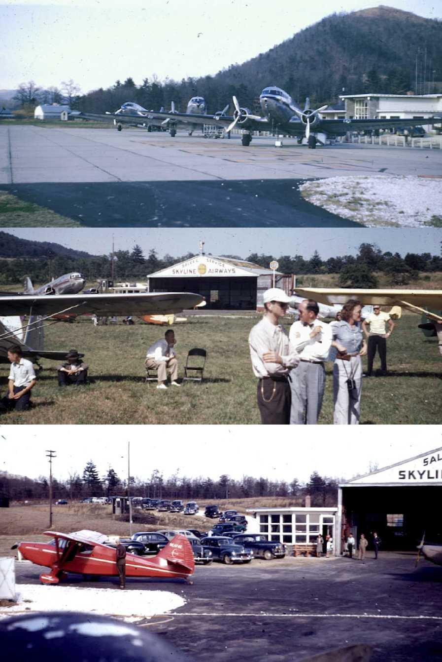
5

6 A series of 3 undated photos (circa 1950s?) of 3 DC-3s in front of the Asheville Hendersonville Airport terminal, and other aircraft in front of the Skyline Airways hangar (courtesy of Mike Whitt). Mike reported, The photos were sent to me by the daughter of the man who was the FBO at this airport. The last dated photos which have been located showing the Asheville-Henderson Airport still in operation was a series of 1954 photos by James Brown. This photo shows a Piper in front of the FBO hangar. James recalled, I had just gotten my drivers license & I would drive out there to watch the planes. I took my first plane ride there in a J-3 Cub, we flew out to Asheville & back, it was the first thrill of my life.

7 A 1954 photo by James Brown of Asheville-Henderson's control tower which was just to the left of the hangar.

8 A 1954 photo by James Brown of Asheville-Henderson, showing a Piper Apache & a Delta DC-3. The DC-3 airliners that served the airport were Capitol, Delta, and Piedmont Airlines. The Asheville-Hendersonville Airport also had some use in testing of ejection seats. The Stencel Aeronautical Research Corporation (which produced aircraft ejection seats) had a plant "located about 2 miles from the Asheville Airport on the main access road from Route 25", according to Hillis "Al" Cunliffe. "My father worked for the Stencel organization from the day it opened it's doors in 1958 until his retirement in He was one of the original dozen people hired by the company's founder, Fred Stencel. He maintained the 3 different aircraft the company operated to support their R&D efforts." The airplanes were kept the Asheville Regional Airport. Over a period of several years they owned an SNJ-5, a TBM-3 and a Douglas A-26. The SNJ-5 & TBM were operated at the same time,
 depicted the Asheville Hendersonville Airport as having 3 paved runways (with the longest being the 4,079' Runway 4/22), as well as a")
9 but the A-26 was the last airplane they had, for only a year or so." The 1960 Jeppesen Airway Manual (courtesy of Chris Kennedy) depicted the Asheville Hendersonville Airport as having 3 paved runways (with the longest being the 4,079' Runway 4/22), as well as a taxiway leading to a ramp on the east side of the field, around which were clustered a large number of small buildings & a tower (a control tower?). In January 1961 the new Asheville Airport (today's Asheville Regional Airport) was opened 3 miles to the west. The new airport featured a much longer runway, which would be more compatible with modern airline flights.

10 Both the new & old Asheville Airports were depicted on the January 1961 Charlotte Sectional Chart (courtesy of Chris Kennedy). Asheville-Henderson Airport was described as having a 4,100' hard-surface runway. The Asheville-Hendersonville Airport was closed at some point between , as it was labeled "Abandoned airport" on the May 1963 Charlotte Sectional Chart (courtesy of Chris Kennedy). Paul Cotrufo recalled, "When I visited that old airport in 1973, it was 'way out in the boonies', no sign of urban development anywhere, horse & farm country." According to Hillis "Al" Cunliffe, "The old airport was used as a drag strip for several years, then became an industrial park." As seen in the 1994 USGS aerial photo, the outline of 3 former runways were still recognizable at the site of the original airport. Numerous large industrial buildings had been built on & along the former runways. Recent street maps label the property of the former airport as the Cane Creek Industrial Park.
11 Ironically, as of 2004, the site of the former Asheville-Hendersonville Airport still has some aviation use. The Cane Creek Airport is listed as of 2004 in the Airport/Facility Directory as a private airfield. It consists of a 2,680' turf Runway 4/22, visible immediately adjacent to the northwest side of the large industrial building in the above aerial photo. The owner is listed as L. A. White, and a total of 7 aircraft are listed as being based at the field, including 5 single engine aircraft & 2 gliders. Several small Quonset-hut style buildings just north of the large building may serve as hangars for the field. Thanks to Hillis "Al" Cunliffe for pointing out this reuse of the old field.

12 A circa 2006 aerial view looking north at the remains of 2 runways & the taxiway leading to the former ramp, now covered by an industrial building. The site of the Asheville-Hendersonville Airport is located north of the intersection of Mills Gap Road & L A White Road. Thanks to Paul Cotrufo for pointing out this airfield.
Aero Club Airport / Ashburn, Ashburn, IL
 Aero Club Airport / Ashburn, Ashburn, IL 41.74 North / 87.74 West (West of Chicago Midway Airport, IL) The Aero Club Airport, as depicted on the March 1937 Chicago Sectional Chart (courtesy of Chris Kennedy).
Somerset Hills Airport (N64), Basking Ridge, NJ
, Basking Ridge, NJ") Page 1 of 10 Somerset Hills Airport (N64), Basking Ridge, NJ 40.69 North / 74.53 West (West of New York, NY) A 1932 postmark commemorating the dedication of the Somerset Hills Airport (courtesy of Ed Drury).
Page 1 of 10 Somerset Hills Airport (N64), Basking Ridge, NJ 40.69 North / 74.53 West (West of New York, NY) A 1932 postmark commemorating the dedication of the Somerset Hills Airport (courtesy of Ed Drury).
Tunnel Meadows Airport, Tunnel Meadows, CA North / West (Southeast of Fresno, CA)
") Tunnel Meadows Airport, Tunnel Meadows, CA 36.38 North / 118.26 West (Southeast of Fresno, CA) A 1931 photo of Pat Decano at in front of 2 Army Air Corps biplanes which brought Col. Hap Arnold from March
Tunnel Meadows Airport, Tunnel Meadows, CA 36.38 North / 118.26 West (Southeast of Fresno, CA) A 1931 photo of Pat Decano at in front of 2 Army Air Corps biplanes which brought Col. Hap Arnold from March
Ring s Reflections. Tucson International Airport s Historic Hangars
 Ring s Reflections by Bob Ring Tucson International Airport s Historic Hangars I want to correct a mistake I made in the final column in my six-part series on Tucson history (April 18, 2013), in which
Prepared By: Mead & Hunt, Inc Port Lansing Road Lansing, MI 48906
 Master Plan The preparation of this document was financed in part through a planning grant from the Federal Aviation Administration (FAA) as provided under Section 505 of the Airport and Airway Improvement
aircargo center Charlotte Charlotte Your Cargo Connection Connecting The Carolinas to the World
 Charlotte aircargo center Connecting The Carolinas to the World Charlotte Looking for an affordable alternative to Atlanta and Washington? Consider Charlotte Air Cargo Center for your cargo connections.
aircargo center Charlotte Charlotte Your Cargo Connection Connecting The Carolinas to the World
 Charlotte aircargo center Connecting The Carolinas to the World Charlotte Looking for an affordable alternative to Atlanta and Washington? Consider Charlotte Air Cargo Center for your cargo connections.
Revision 2 03/15/2017. North Coast Flight School Inc.
 North Coast Flight School Inc. Page 2 of 19 Commercial Airplane Training Course Outline FORM REVISION This Revisions sheet shall be retained in your manual until receipt of the next revision. Place this
WEST VALLEY FLYING CLUB FLIGHT PATH
 WEST VALLEY FLYING CLUB FLIGHT PATH EDITOR: Brian R. Baker April 12, 2018 Vol. 5 Number 4 Editor s Rant It has been another busy month, with several flyouts and the traditional breakfast meetings every
Revision 3 03/15/2017. North Coast Flight School Inc.
 North Coast Flight School Inc. Page 2 of 18 FORM REVISION Private Pilot Training Course Outline This Revisions sheet shall be retained in your manual until receipt of the next revision. Place this sheet
Future Economic Benefits to North Carolina from Session Law (34.19a-34.19c) Investments. Bobby Walston, Director of Aviation April 2, 2018
 Investments. Bobby Walston, Director of Aviation April 2, 2018") Future Economic Benefits to North Carolina from Session Law 2017-57 (34.19a-34.19c) Investments Bobby Walston, Director of Aviation April 2, 2018 2016 Study Results (Summary) Jobs Economic Contribution
Future Economic Benefits to North Carolina from Session Law 2017-57 (34.19a-34.19c) Investments Bobby Walston, Director of Aviation April 2, 2018 2016 Study Results (Summary) Jobs Economic Contribution
Addendum - Airport Development Alternatives (Chapter 6)
") Bowers Field Addendum - Airport Development Alternatives (Chapter 6) This addendum to the Airport Development Alternatives chapter includes the preferred airside development alternative and the preliminary
Bowers Field Addendum - Airport Development Alternatives (Chapter 6) This addendum to the Airport Development Alternatives chapter includes the preferred airside development alternative and the preliminary
Norfolk International Airport
 Norfolk International Airport Master Plan Update Technical Advisory Committee Meeting #1 Community Advisory Committee Meeting #1 January 24, 2018 Agenda Project Background Introductions Overview of Airport
Draft Palo Alto Airport Master Plan Report County of Santa Clara, California October 2005
 Draft Palo Alto Airport Master Plan Report County of Santa Clara, California October 2005 County of Santa Clara Board of Supervisors Donald F. Gage Blanca Alvarado Peter A. McHugh James T. Beall, Jr. Liz
Meadow Lake Airport Glider Operations Procedures
 Meadow Lake Airport Glider Operations Procedures The MLAA Board has delegated to High Flights Soaring Club responsibility for coordinating glider activities at Meadow Lake Airport and establishing procedures
Casper/Natrona County International Airport Master Plan Update Technical Advisory Committee Meeting Two - October 14th, :30 PM
 Casper/Natrona County International Airport Master Plan Update Technical Advisory Committee Meeting Two - October 14th, 2014 1:30 PM Casper/Natrona County International Airport Master Plan Update Policy
Existing Facilities. Current and Forecast Demand
 Existing Facilities Albert Whitted Airport is owned and operated by the City of St. Petersburg ( City ). The airport property encompasses approximately 119 acres. The airport is served by two intersecting
SouthwestFloridaInternational Airport
 SouthwestFloridaInternational Airport SouthwestFloridaInternationalAirportislocatedinLee CountyalongtheGulfCoastofSouthFlorida,tenmiles southeastofthefortmyerscentralbusinessdistrict. Theprimaryhighwayaccesstotheairportfrom
Meadow Lake Airport Glider Operations Procedures
 Meadow Lake Airport Glider Operations Procedures The MLAA Board has delegated to High Flights Soaring Club responsibility for coordinating glider activities at Meadow Lake Airport and establishing procedures
Chapter 5 Airport Development Alternatives
 Chapter 5 Airport Development Alternatives Introduction CHAPTER 5 AIRPORT DEVELOPMENT ALTERNATIVES JUNE 2013-1 Evaluation Process No-Action Alternative CHAPTER 5 AIRPORT DEVELOPMENT ALTERNATIVES JUNE 2013-2
Agenda: SASP SAC Meeting 3
 Agenda: SASP SAC Meeting 3 Date: 04/12/18 Public Involvement Plan Update Defining the System Recommended Classifications Discussion Break Review current system Outreach what we heard Proposed changes Classification
Municipal Leadrship Development Program LOOKING FOR DOLLARS WRWA LAND DEVELOPMENT PROJECT
 The City of Oklahoma City Department of Airports 2009-2010 Municipal Leadrship Development Program LOOKING FOR DOLLARS WRWA LAND DEVELOPMENT PROJECT WILL ROGERS WORLD AIRPORT WILL ROGERS WORLD AIRPORT
COMMERCIAL AND GENERAL AVIATION
 Existing Facilities Daytona Beach International Airport is served by a number of airside and landside facilities. The airport has three asphalt runways: Runway 07L/25R (10,500 feet long by 150 feet wide),
ArcadiaMunicipalAirportislocatedonthesoutheast sideofarcadia,southofstateroute70,westofstate Route31,andisaccessiblefrom AirportRoad.
 Arcadia GeneralAviationAirport ArcadiaMunicipalAirportislocatedonthesoutheast sideofarcadia,southofstateroute70,westofstate Route31,andisaccessiblefrom AirportRoad.Arcadia islocatedapproximately30milesnortheastoftheport
Chapter 1 Introduction and Project Overview
 Chapter 1 Introduction and Project Overview Kittitas County in cooperation with the Federal Aviation Administration (FAA) is updating the Airport Master Plan for Bowers Field Airport (FAA airport identifier
Chapter 1. Inventory
 Chapter 1. Inventory Chapter 1. INVENTORY The collection and inventory of data pertinent to James M. Cox Dayton International Airport (DAY) is the initial step in a Master Plan Study and serves as the
Kittitas County Airport Bowers Field Airport Master Plan Planning Advisory Committee Meeting #1 April 6, 2016
 Kittitas County Airport Bowers Field Airport Master Plan Planning Advisory Committee Meeting #1 April 6, 2016 Project Team Kittitas County, WA Airport Owner (Sponsor) and Operator, Land Use Century West
RECONSTRUCT/REHABILITATE TRANSIENT APRON AND TAXIWAY 'A' PHASING PLAN - PHASE 1
 PHASING PLAN - PHASE 1 2 Weeks PHASE 1 SCOPE OF WORK Phase 1 consists of the reconstruction of a portion of Taxiway 'A' and the crack seal and seal coat of the North Apron. The portion of Taxiway 'A' to
Fairbanks X. Scenery Overview: Product: Company Aerosoft. Price as rated $ Flight Simulator FSX
 Fairbanks X BY MIKE CAMERON. Scenery Overview: Fairbanks X developed by SimWings and distributed by Aerosoft is an accurate version of Fairbanks International Airport (PAFA) for FSX. Fairbanks International
II.J. 14 CFR and Publications
 References: 14 CFR Parts 1, 61, 91; NTSB Part 830; AC 00-2; FAA-H-8083-25; POH/AFM; AIM Objectives Key Elements Elements Schedule Equipment IP s Actions SP s Actions Completion Standards The student should
NON MOVEMENT AREA DRIVERS TRAINING
 NON MOVEMENT AREA DRIVERS TRAINING Introduction Introduction The Federal Aviation Administration (FAA) and the Transportation Security Administration (TSA) have instituted rules and regulations requiring
Current and Forecast Demand
 Existing Facilities Jacksonville International Airport (JIA) is served by a number of airside and landside facilities. There are two runways that serve the airport in an open V configuration. The Annual
Aviation History Through Photos. A look at some of the photos displayed in the LaGuardia Air Traffic Control Tower Exhibit
 Aviation History Through Photos A look at some of the photos displayed in the LaGuardia Air Traffic Control Tower Exhibit Photos courtesy of FAA, the Port Authority of New York and New Jersey, the Library
6.1 INTRODUCTION 6.2 AIRSIDE ALTERNATIVES NORTH PERRY AIRPORT MASTER PLAN UPDATE RUNWAY LENGTH REQUIREMENTS SECTION 6: ALTERNATIVES ANALYSIS
 6.1 INTRODUCTION In the previous chapter, facility needs for the 20-year planning horizon were identified. The next step in the planning process is to identify and evaluate the various ways certain facilities
SASP Advisory Committee Meeting #3
 SASP Advisory Committee Meeting #3 MnDOT Office of Aeronautics #FlyMN www.minnesotago.org 1 Agenda Public Involvement Plan Update Defining the System Classification Review Minimum System Objectives Performance
National Transportation Safety Board Washington, D.C
 E PLURIBUS UNUM NATIONAL TRA SAFE T Y N S PORTATION B OAR D National Transportation Safety Board Washington, D.C. 20594 Safety Recommendation Date: June 25, 2004 In reply refer to: A-04-48 through -50
Norfolk International Airport History
 Norfolk International Airport History As early as 1903, Hampton Roads was making a connection with aviation. The Virginian-Pilot based in Norfolk, Va. was one of the first newspapers in the country to
SAFETY & AIRCRAFT OPERATIONS LEGISLATIVE & REGULATORY ADVOCACY NETWORKING & COMMERCE EDUCATION & CAREER DEVELOPMENT BUSINESS MANAGEMENT RESOURCES
 DEDICATED TO HELPING BUSINESS ACHIEVE ITS HIGHEST GOALS. AIRPORT AUDIT TOOL The Airport Audit Tool is designed to assist operators in identifying current and potential hazards related to airport operations
Dallas Love Field Capital Program. September 16, 2015
 Dallas Love Field Capital Program September 16, 2015 1 The Dallas Airport System Dallas Love Field, Dallas Executive Airport, Downtown Vertiport A $86 million City of Dallas enterprise Operated by the
Provided by: South Central Illinois Regional Planning & Development Commission
 Provided by: South Central Illinois Regional Planning & Development Commission Economic Impact Summary of Flora Municipal Airport (KFOA) Table of Content Introduction...1 General Information...3 Ownership...3
AMG Airport Management
 AMG 1204 Airport Management By Zuliana Ismail, 2010 Airport Managements Course Outlines Chapter 1: Introduction To Airport Chapter 2: Airport Components Chapter 3: Air Traffic Control Tower Chapter 4:
The Leading. - October
 The Leading Leading Edge Edge Monthly Newsletter of the - October 2016 - Low and Over by a Harvard The roar of that big Pratt and Whitney radial with its propeller tips breaking the sound barrier is unmistakable
SOPs for Cedar Valley Airport UT10
 SOPs for Cedar Valley Airport UT10 Cedar Valley Airport is a privately owned airport located approximately 10 miles west of Lehi, Ut and 5 miles northeast of Cedar Fort, UT. The airport location is N40.3572
President s Corner by Vic Briley. In This Issue by Phil Curtiss. Gaylord, MI EAA Chapter November 2008.
 Gaylord, MI EAA Chapter 1095 www.eaa1095.org November 2008 President s Corner by Vic Briley Hello fellow flyers: In case you haven t heard, former president (Doug Hancock) was in the hospital, in Petoskey,
The offers operators increased capacity while taking advantage of existing airport infrastructure. aero quarterly qtr_03 10
 The 747 8 offers operators increased capacity while taking advantage of existing airport infrastructure. 14 aero quarterly qtr_03 10 Operating the 747 8 at Existing Airports Today s major airports are
Airport Closure Evaluation Report Prepared by MnDOT Aeronautics
 Airport Closure Evaluation Report Prepared by MnDOT Aeronautics Impacts of Closing The Murdock Municipal Airport (23Y) Summary Impacts of Closing the Murdock Municipal Airport (23Y) Closing a publicly
MESA COUNTY DEPARTMENT OF PUBLIC WORKS Administration - Building - Engineering Road and Bridge Traffic - Planning - Solid Waste Management
 MESA COUNTY DEPARTMENT OF PUBLIC WORKS Administration - Building - Engineering Road and Bridge Traffic - Planning - Solid Waste Management 200 S. Spruce St. P.O. Box 20,000 Grand Junction, Colorado 81502-5022
Lake Tahoe Airport Master Plan
 Lake Tahoe Airport Master Plan City Council Briefing October 20, 2015 What is an Airport Master Plan? a comprehensive study of an airport [that] usually describes the short, medium, and long term development
Lake Tahoe Airport Master Plan Public Meeting March 16, 2015
 Lake Tahoe Airport Master Plan Public Meeting March 16, 2015 What is an Airport Master Plan? a comprehensive study of an airport [that] usually describes the short, medium, and long term development plans
BRIEF OVERVIEW ORLANDO NORTH AIRPARK ENTERPRISE ZONE
 BRIEF OVERVIEW ORLANDO NORTH AIRPARK ENTERPRISE ZONE The Orlando North Airpark Enterprise Zone is a rare opportunity for any company desiring to relocate or open a new operation in the State of Florida.
Chapter The All-new, World-class Denver International Airport Identify Describe Know Describe Describe
 Chapter 10 The aerospace subject is very large and diverse. As seen in previous chapters, there are many subject areas. So far you have learned about history, weather, space and aerodynamics. Now you will
Summary of Committee Discussion/Questions Metropolitan Transportation Services Senior Planner Russ Owen presented this item.
 Committee Report Business Item No. 2017-191 Transportation Committee For the Metropolitan Council meeting of September 13, 2017 Subject: Final Crystal Airport 2035 Long Term Comprehensive Plan (LTCP) Proposed
Document prepared by MnDOT Office of Aeronautics and HNTB Corporation. MINNESOTA GO STATE AVIATION SYSTEM PLAN
 LAST UPDATE JULY 2013 Acknowledgements The preparation of this document was financed in part by a grant from the Federal Aviation Administration (Project No: 3-27-0000-07-10), with the financial support
Public Information Meeting. September 2015
 W ki P O & T / Working Papers One & Two/ Public Information Meeting September 2015 Agenda Introductions and Opening Comments Project Overview, Process, and Schedule Review Materials from Working Papers
NAVIGATION: CHARTS, PUBLICATIONS, FLIGHT COMPUTERS (chapters 7 & 8)
") NAVIGATION: CHARTS, PUBLICATIONS, FLIGHT COMPUTERS (chapters 7 & 8) LONGITUDE AND LATITUDE 1. The location of an airport can be determined by the intersection of lines of latitude and longitude. a. Lines
NAVIGATION: CHARTS, PUBLICATIONS, FLIGHT COMPUTERS (chapters 7 & 8) LONGITUDE AND LATITUDE 1. The location of an airport can be determined by the intersection of lines of latitude and longitude. a. Lines
Purpose and Need for the Proposed Project
 Purpose and Need for the Proposed Project Introduction Snohomish County Airport/Paine Field (PAE) is located in Snohomish County, Washington, approximately 20 miles north of Seattle. Figure A1 depicts
State of the Airport Robert S. Bowen, Executive Director October 18, 2018
 Robert S. Bowen, Executive Director October 18, 2018 A Year of Change The last year will be remembered as a period when the airlines, bolstered by a growing national economy, moderate fuel prices and changing
Final Approach Simulations: Toronto City for X-Plane 10
 Final Approach Simulations: Toronto City for X-Plane 10 www.finalapproachsim.com 1 Table of contents Features.. Page 3 Toronto City Airport (CYTZ)..Page 4 Hospital heliports.page 6 Night lighting....page
Naval Air. thirty five Portland, that links. purposes. First and. in the late 1930s served as. has been. The And Closure
 Midcoast Regional Redevelopment Authority Request for Qualifications From Fixed Base Operators Brunswick, Maine Introduction and Background The Midcoast Regional Redevelopment Authority ( MRRA ) is soliciting
COLUMBUS REGIONAL AIRPORT AUTHORITY. Economic Impact Study Update. Executive Summary
 COLUMBUS REGIONAL AIRPORT AUTHORITY Economic Impact Study Update Executive Summary November 2012 Hearing a plane overhead is an everyday occurrence. But how many people stop to think that what they are
TABLE OF CONTENTS
 Sioux City ATCT TABLE OF CONTENTS Welcome Letter 3 Sioux Gateway Airport 4 Facility Organizational Chart 6 Expectations of Employees 7 Polices 8 Local Area Information 9 Online Resources 10 Airport Diagram
RULES OF TENNESSEE DEPARTMENT OF TRANSPORTATION AERONAUTICS DIVISION CHAPTER LICENSING AND REGISTRATION OF AIRPORTS TABLE OF CONTENTS
 RULES OF TENNESSEE DEPARTMENT OF TRANSPORTATION AERONAUTICS DIVISION CHAPTER 1680-1-2 LICENSING AND REGISTRATION OF AIRPORTS TABLE OF CONTENTS 1680-1-2-.01 Purpose 1680-1-2-.06 Repealed 1680-1-2-.02 Definitions
Meeting Summary ABE Master Plan Project Advisory Group (PAG) Meeting #3 August 15, Shannon Eibert, C&S Companies
 Meeting #3 August 15, Shannon Eibert, C&S Companies") Meeting Summary ABE Master Plan Project Advisory Group (PAG) Meeting #3 August 15, 2017 Prepared by: File: Attendees: Shannon Eibert, C&S Companies N93.012.001 See Sign-In List A third meeting was held
Meeting Summary ABE Master Plan Project Advisory Group (PAG) Meeting #3 August 15, 2017 Prepared by: File: Attendees: Shannon Eibert, C&S Companies N93.012.001 See Sign-In List A third meeting was held
Quarterly Newsletter August, 2017 Volume 10, Issue 3. Table of Contents: Find us on Social! Airport News. CoMMUnity Messages
 Quarterly Newsletter August, 2017 Volume 10, Issue 3 Table of Contents: Page 1-3: Runway 5/23 Keel Repair Project Recap Page 4: New Fuel Farm Opens Page 5: RWY 5-23 Obstructions and Minimums Update Page
The Future of Aviation for Central New Mexico
 The Future of Aviation for Central New Mexico MISSION STATEMENT THE WHOLE AIRPORT EXPERIENCE HISTORY SPECIFICATIONS FACILITIES SERVICES RECENT IMPROVEMENTS FUTURE DEVELOPMENT & USE USER PROFILE The mission
Draft Concept Alternatives Analysis for the Inaugural Airport Program September 2005
 Section 10 Preferred Inaugural Airport Concept 10.0 Introduction The Preferred Inaugural Airport Concept for SSA was developed by adding the preferred support/ancillary facilities selected in Section 9
LANCASTER AIRPORT DRIVER TRAINING PROGRAM
 LANCASTER AIRPORT DRIVER TRAINING PROGRAM INTRODUCTION 1. Airfield Driving Basics 2. Movement / Non-Movement Area 3. Airfield Signs, Markings & Lighting 4. Airfield Communications 5. Aviation Phonetics
Study Committee Meeting. September 2015
 W ki P T / Working Paper Two/ Study Committee Meeting September 2015 Agenda Introductions and Opening Comments Project Overview, Process, and Schedule Review Materials from Working Paper Two Comments,
City of Venice Venice Municipal Airport
 City of Venice Venice Municipal Airport Airfield Access Policy The City of Venice is responsible for safe and secure operation of the Venice Municipal Airport. Access to the airfield is authorized on the
Chapter 2 FINDINGS & CONCLUSIONS
 Chapter 2 FINDINGS & CONCLUSIONS 2.01 GENERAL Dutchess County acquired the airport facility in 1947 by deed from the War Assets Administration. Following the acquisition, several individuals who pursued
Be a part of Albuquerque's next emerging destination place LOCATED BETWEEN ABQ INTERNATIONAL SUNPORT AND KIRKLAND AIR FORCE BASE
 RETAIL PADS & SHOPS @ SEC Gibson & Girard SE Albuquerque, NM 87106 GROUND LEASE OR BUILD-TO-SUIT THE LANDING Be a part of Albuquerque's next emerging destination place LOCATED BETWEEN ABQ INTERNATIONAL
Business Aviation: Operations and Service Quality by Provider Organisations. Macao, September Captain Scott Macpherson
 Business Aviation: Operations and Service Quality by Provider Organisations Macao, September 2013 Captain Scott Macpherson Business Aviation: Operations and Service Quality by Provider Organizations Today
COMMERCIAL AND GENERAL AVIATION
 Existing Facilities Melbourne International Airport is served by three runways and a number of airside and landside facilities. The runways include Runway 4/22 (3,001 feet long by 75 feet wide), Runway
TO: Planning Advisory Committee (PAC) Members RE: Pangborn Airport Master Plan PAC Meeting #4 Presentation Material DATE: July 18, 2017
 Members RE: Pangborn Airport Master Plan PAC Meeting #4 Presentation Material DATE: July 18, 2017") TO: Planning Advisory Committee (PAC) Members RE: Pangborn Airport Master Plan PAC Meeting #4 Presentation Material DATE: July 18, 2017 Please find attached for your review prior to the PAC Meeting #4,
TO: Planning Advisory Committee (PAC) Members RE: Pangborn Airport Master Plan PAC Meeting #4 Presentation Material DATE: July 18, 2017 Please find attached for your review prior to the PAC Meeting #4,
THE STATE HISTORICAL SOCIETY OF MISSOURI RESEARCH CENTER-KANSAS CITY
 THE STATE HISTORICAL SOCIETY OF MISSOURI RESEARCH CENTER-KANSAS CITY K0969 Hugh Gene Graff (1919-2013) Papers 1939-2007 4 cubic feet, oversize Graff was general manager of flying for Trans World Airlines
Driving Training Class. Presented by: Lancaster Airport Authority
 Driving Training Class Presented by: Lancaster Airport Authority Driving is a Privilege Driving on the airport, airport apron and ramps is a privilege and can be revoked at anytime for any reason. Violations
Report Cover Page. Physical Address: Wallace Alley St. Suite 1 Kingsport, Tennessee, 37663
 Report Cover Page Contact: Clay Walker, CEcD, CEO 423-279-7684 cwalker@networkstn.com Physical Address: 10368 Wallace Alley St. Suite 1 Kingsport, Tennessee, 37663 Mailing Address: P.O. Box 747 Blountville
Charles Ingram Stanton, Sr., Papers
 Michael Sean Margolius and David Schwartz 2011 National Air and Space Museum Archives 14390 Air & Space Museum Parkway Chantilly, VA 20151 NASMRefDesk@si.edu http://airandspace.si.edu/research/resources/archives/
Table of Contents. List of Tables. Cincinnati/Northern Kentucky International Airport 2035 Master Plan Update
 Table of Contents 7.1. Airport Layout Plan (Existing Conditions)... 2 7.2. Airport Layout Plan (Future Conditions)... 3 7.3. Technical Data Sheet... 5 7.4. Commercial Terminal Area Drawing... 5 7.5. East
Public Review Draft South County Airport Master Plan Report. County of Santa Clara San Martin, California
 Public Review Draft South County Airport Master Plan Report County of Santa Clara San Martin, California July 2005 County of Santa Clara Board of Supervisors Donald F. Gage Blanca Alvarado Peter A. McHugh
If You Build It, Will It Fly????? Study Guide
 If You Build It, Will It Fly????? Study Guide The test will have questions and a written assignment. Together, both are worth 20% of the project. Questions will including multiple choice, matching, calculations,
Rochester-Olmsted Planning Department Signature Flight Support. Destination Medical Center (DMC)
") Master Plan Community Input Committee Meeting #2 February 20, 2019 1:00-2:30 p.m. University of Minnesota-Rochester University Square, Room 419 Meeting Notes Committee Attendees Jeff Ellerbusch Rochester-Olmsted
Master Plan Community Input Committee Meeting #2 February 20, 2019 1:00-2:30 p.m. University of Minnesota-Rochester University Square, Room 419 Meeting Notes Committee Attendees Jeff Ellerbusch Rochester-Olmsted
Jax Navy Flying Club Course Rules
 Jax Navy Flying Club Course Rules Responsibilities. The Jax Navy Flying Club maintains responsibility for ensuring that all pilots operating out of Naval Air Station Jacksonville are familiar with local
Guide to the Bernard L. Whelan Collection
 University of Dayton ecommons Guides to Archival and Special Collections University Libraries 7-10-2015 Guide to the Bernard L. Whelan Collection Kristina S. Klepacz University of Dayton Follow this and
Ref. AIM Para AOPA Air Safety Foundation Supported by the FAA Ref. AIM Para Supported by the FAA
 ILS Critical Area Holding Position Sign: ATC may hold you at this sign, on a taxiway, when the instrument landing system is being used at the airport. Aircraft taxiing beyond this point may interfere with
JACIP-AIRPORT PROJECT DETAIL REPORT August 15, 2007
 JACIP-AIRPORT PROJECT DETAIL REPORT August 15, 27 11242 1 of 14 Sponsor: City of Naples Airport Authority NPIAS No.: 12-53 Sponsor ID: 122 Airport ID: APF Site No.: 3379.*A 11242 Airport Project ID: 1
CRATER LAKE KLAMATH REGIONAL AIRPORT JULY 23, 2018
 WELCOME TO THE I would like to take the time to welcome you to the new Airport Connection. This bi monthly newsletter will be distributed the first week of every odd numbered month by Airport Administration.
Chapter 4.0 Alternatives Analysis
 Chapter 4.0 Alternatives Analysis Chapter 1 accumulated the baseline of existing airport data, Chapter 2 presented the outlook for the future in terms of operational activity, Chapter 3 defined the facilities
Technical Memorandum. Synopsis. Steve Carrillo, PE. Bryan Oscarson/Carmen Au Lindgren, PE. April 3, 2018 (Revised)
") Appendix D Orange County/John Wayne Airport (JWA) General Aviation Improvement Program (GAIP) Based Aircraft Parking Capacity Analysis and General Aviation Constrained Forecasts Technical Memorandum To:
Appendix D Orange County/John Wayne Airport (JWA) General Aviation Improvement Program (GAIP) Based Aircraft Parking Capacity Analysis and General Aviation Constrained Forecasts Technical Memorandum To:
Milton. PeterPrinceAirportislocatedinSantaRosaCounty, approximatelythreemileseastofmilton.
 Milton GeneralAviationAirport PeterPrinceAirportislocatedinSantaRosaCounty, approximatelythreemileseastofmilton. Existing Facilities Peter Prince Airport is served by one runway, Runway 18/36, 3,700 feet
JUNEAU RUNWAY INCURSION MITIGATION (RIM) PROGRAM JANUARY 25, 2017
 PROGRAM JANUARY 25, 2017") JUNEAU RUNWAY INCURSION MITIGATION (RIM) PROGRAM JANUARY 25, 2017 1 Agenda Program Description Runway Incursions Design and Geometry Deficiencies Runway 8/26 Operations Potential Mitigation Next Steps
JUNEAU RUNWAY INCURSION MITIGATION (RIM) PROGRAM JANUARY 25, 2017 1 Agenda Program Description Runway Incursions Design and Geometry Deficiencies Runway 8/26 Operations Potential Mitigation Next Steps
Centennial Airport Flight school practice areas. A PowerPoint Presentation By Michael Shannon Chief Flight Instructor Aspen Flying Club
 Centennial Airport Flight school practice areas A PowerPoint Presentation By Michael Shannon Chief Flight Instructor Aspen Flying Club The Denver metro area airspace is very complex and congested. Centennial
print materials visit information on free live seminars, online courses, and
 The AOPA Air Safety Foundation is dedicated to making flying easier and safer for general aviation pilots. For information on free live seminars, online courses, and print materials visit. ILS Critical
PREFERRED PLAN Kahului Airport Master Plan and Noise Compatibility Program Update
 PREFERRED PLAN Kahului Airport Master Plan and Noise Compatibility Program Update AIRPORTS DIVISION DEPARTMENT OF TRANSPORTATION March 13, 2012 AGENDA Introduction Purpose and Meeting Objectives Kahului
Brian Ryks Executive Director and CEO
 Brian Ryks Executive Director and CEO MAC Commissioners MAC Finances 2016 Budgeted Operating Revenues Utilities and Other 5% Airline Rates and Charges 34% Rents and Fees 14% Concessions 47% 2016 Budgeted
#1: Have a flight that makes it a challenge to navigate. Have you wondering Am I going the right way? Is that Highway 40?
 One of the things we have not done in our couple months of VFR adventures is night flying. So I thought, what would be a good flight that accomplishes a couple interesting night related things? Here is
Point A to Point B Arrival By Jim Sweeney
 Point A to Point B Arrival By Jim Sweeney The first two installments of From Point A to Point B were published in the October and January issues of UltraFlight Magazine. They covered the Preparation/Departure
Appendix C AIRPORT LAYOUT PLANS
 Appendix C AIRPORT LAYOUT PLANS Appendix C AIRPORT LAYOUT PLANS Airport Master Plan Santa Barbara Airport As part of this Airport Master Plan, the Federal Aviation Administration (FAA) requires the development
1.1.3 Taxiways. Figure 1-15: Taxiway Data. DRAFT Inventory TYPICAL PAVEMENT CROSS-SECTION LIGHTING TYPE LENGTH (FEET) WIDTH (FEET) LIGHTING CONDITION
 WIDTH (FEET) LIGHTING CONDITION") 1.1.3 Taxiways EWN has an extensive network of taxiways and taxilanes connecting the terminal, air cargo, and general aviation areas with the runways as listed in Figure 1-15. A 50-foot wide parallel taxiway
1.1.3 Taxiways EWN has an extensive network of taxiways and taxilanes connecting the terminal, air cargo, and general aviation areas with the runways as listed in Figure 1-15. A 50-foot wide parallel taxiway
RSAT RUNUP ANALYSIS 1. INTRODUCTION 2. METHODOLOGY
 RSAT RUNUP ANALYSIS 1. INTRODUCTION The FAA Runway Safety Action Team (RSAT) is a team of FAA staff that works with airports to address existing and potential runway safety problems and issues. The RSAT