COMPREHENSIVE LAND USE PLAN SANTA CLARA COUNTY PALO ALTO AIRPORT
|
|
|
- Kenneth Cross
- 6 years ago
- Views:
Transcription
1 COMPREHENSIVE LAND USE PLAN SANTA CLARA COUNTY PALO ALTO AIRPORT ADOPTED By the SANTA CLARA COUNTY AIRPORT LAND USE COMMISSION San Jose, California November 19, 2008 Prepared by Walter B. Windus, PE Aviation Consultant Saratoga Creek Dr. Saratoga, California (408)
2 ACKNOWLEDGEMENTS The author gratefully acknowledges the review, comments and recommendations provided by John Blair, Bob Sturdivant, and Arthur Knopf in the development of this CLUP. The assistance of James Kiehl, Palo Alto Airport management and the County of Santa Clara is also acknowledged with thanks and appreciation. ii
3 TABLE OF CONTENTS 1 INTRODUCTION AND BACKGROUND PURPOSE AND SCOPE LEGAL AUTHORITY BACKGROUND AND HISTORY CONTENTS OF THE COMPREHENSIVE LAND USE PLAN TECHNICAL REFERENCE DOCUMENT PALO ALTO AIRPORT AND ENVIRONS AIRPORT ROLE AIRPORT LAYOUT PLAN Existing Airport Facilities Future Airport Facilities AVIATION ACTIVITY Based Aircraft Aircraft Operations AIRPORT ENVIRONS LAND USE COMPATIBILITY GUIDELINES OVERVIEW LAND USE COMPATIBILITY CRITERIA NOISE RESTRICTION AREA Airport Noise Descriptors Land Use Compatibility Standards California Land Use Compatibility Standards - Santa Clara County Land Use Compatibility Standards City of Palo Alto Palo Alto Airport Noise Contours Aircraft Operations Impacts on Land Use HEIGHT RESTRICTION AREA Primary Surface Approach Surface Transitional Surface Horizontal Surface Conical Surface Summary SAFETY RESTRICTION AREA Runway Protection Zone Turning Sector Defined Inner Safety Zone Turning Safety Zone Outer Safety Zone Sideline Safety Zone Traffic Pattern Zone OVERFLIGHT RESTRICTION AREA AIRPORT INFLUENCE AREA iii
4 4 LAND USE COMPATIBILITY POLICIES LAND USE PLANNING ISSUES JURISDICTIONAL RESPONSIBILITIES Santa Clara County Airport Land Use Commission Affected Local Agencies Airport Owner/Operator Responsibilities COMPATIBILITY POLICIES General Compatibility Noise Compatibility Height Compatibility Tall Structure Compatibility Safety Compatibility Overflight Reconstruction Infill IMPLEMENTATION CONSISTENCY WITH LOCAL PLANS AND ZONING LAND USE DESIGNATIONS Airport Overlay Zones Avigation Easements Buyer Awareness Measures Methods of Calculating Density and Building Occupancy BIBLIOGRAPHY APPENDIX A APPENDIX B iv
5 LIST OF TABLES Table 2-1 Aviation Activity Forecasts Table 3-1 Airport Configuration and Runway Use Table 3-2 Annual Aircraft Operations Table 3-3 FAR Part 77 Surfaces Table 4-1 Noise Compatibility Guidelines Table 4-2 Safety Zone Compatibility Guidelines v
6 LIST OF FIGURES Figure 1 Location Map Figure 2 Airport Layout Plan Figure 3 Palo Alto Typical Aircraft Flight Tracks, Rwy Figure 3 Palo Alto Typical Aircraft Flight Tracks, Rwy Figure 4 General Plan Land Use Figure Aircraft Noise Contours Figure 6 FAR Part 77 Surfaces Figure 7 Airport Safety Zones Figure 8 Airport Influence Area vi
7 Section 1 1 INTRODUCTION AND BACKGROUND 1.1 PURPOSE AND SCOPE This Comprehensive Land Use Plan (CLUP) is intended to safeguard the general welfare of the inhabitants within the vicinity of Palo Alto Airport (also referred to as the "Airport" throughout this report) and the aircraft occupants. This CLUP is also intended to ensure that surrounding new land uses do not affect the Airport s continued operation. This CLUP applies only to those areas within Santa Clara County, and only provides a reference for the use of the San Mateo County Airport Land Use Commission and San Mateo County agencies, to the extent they wish to use it. Specifically, the CLUP seeks to protect the public from the adverse effects of aircraft noise, to ensure that people and facilities are not concentrated in areas susceptible to aircraft accidents, and to ensure that no structures or activities adversely affect navigable airspace. The implementation of this CLUP is intended to prevent future incompatible development from encroaching on the Airport and allow for its development in accordance with the current airport master plan. The aviation activity forecast for the Airport was updated to reflect the existing aviation activity and provide at least a 20-year forecast of activity. The updated aviation activity forecast formed the basis for preparation of 2022 aircraft noise contours. The Airport Master Plan and updated aviation activity forecast and available aircraft noise contours formed the basis for preparation of this CLUP. 1.2 LEGAL AUTHORITY The Public Utilities Code of the State of California, Sections et seq. authorizes each county to establish an Airport Land Use Commission (ALUC) and defines its range of responsibilities, duties and powers. The Santa Clara County Airport Land Use Commission is composed of 7 members, two appointed by the Santa Clara County Board of Supervisors, two appointed by the Santa Clara County City Selection Committee, two appointed by a committee composed of the Aviation Director of San Jose International Airport and the Director of the County Roads and Airports Department and one appointed at large by the ALUC. Section requires the ALUC to formulate and maintain a comprehensive land use plan (CLUP) for the area surrounding each public-use airport within Santa Clara County. A CLUP may also be developed for a military airport at the discretion of the ALUC. The County has four public-use airports, San Jose International, Palo Alto Airport, Reid-Hillview Airport and South County Airport, and one federally owned airport, Moffett Federal Airfield. Palo Alto Airport is defined as a General Aviation Airport (as opposed to an Air Carrier Airport) due to the type of aircraft that use this airport. Section also specifies that comprehensive land use plans will: (a) provide for the orderly growth of each public airport and the area surrounding the airport within the jurisdiction of the commission, and will safeguard the general welfare of the inhabitants within the vicinity of the airport and the public in general. The commission plan shall include and shall be based on a long-range master plan or an airport layout plan, as determined by the Division of Aeronautics of the Department of Transportation, that reflects the anticipated growth of the airport during at least the next 20 years. In formulating a land use plan, the commission may develop height restrictions on buildings, may specify use of land, and may determine building standards, including soundproofing adjacent to airports, within the planning area. The comprehensive land use plan shall be reviewed as often as necessary in order to accomplish its purposes, but shall not be amended more than once in any calendar year. 1-1
8 1.3 BACKGROUND AND HISTORY Legislation passed by the State of California in 1967 mandated the creation of an Airport Land Use Commission in each county that had an airport served by a scheduled airline or operated for use by the general public. In conformance with this legislation the Planning Policy Committee, an existing decisionmaking body with representation from the 5 cities and the County, was designated to be the Airport Land Use Commission (ALUC) for Santa Clara County by the Board of Supervisors and the Select Committee of Mayors. After certification by the California Secretary of State, the Airport Land Use Commission officially came into existence in Santa Clara County in January of Their first land use policy plan was adopted on June 28, The 1973 policy plan (the land use plan preceding this Comprehensive Land Use Plan) was amended in 1974 and 1991, and last adopted by the ALUC in September CONTENTS OF THE COMPREHENSIVE LAND USE PLAN The Comprehensive Land Use Plan contains several major elements: The existing and planned-for facilities at the Airport that are relevant to preparing the CLUP; Appropriate noise, height, and safety restriction policies and land use compatibility standards; Specific findings of compatibility or incompatibility with respect to existing land uses, proposed General Plan land uses, or existing zoning controls; and Specific actions that need to be taken to make the County of Santa Clara and the cities General Plans, Specific Plans, Master Plans and/or Zoning Ordinances consistent with the Comprehensive Land Use Plan. The CLUP establishes an airport land use planning area, referred to as the Airport Influence Area (AIA), which sets the boundaries for application of ALUC Policy. The CLUP contains the relevant policies and guidelines for land use compatibility and specific findings of compatibility or incompatibility of land uses within the AIA. Of particular interest to the ALUC are areas "not already devoted to incompatible uses" and, more specifically, undeveloped lands within the AIA. The planning effort is focused on identifying these lands because the policies and standards of the plan are intended to control the compatibility of future development in these areas. The CLUP is not intended to define allowable land use for a specific parcel of land, although the plan establishes development standards or restrictions that may limit or prohibit certain types of uses and structures on a parcel. The CLUP is not retroactive with respect to existing incompatible land uses, but discusses actions to be taken when expansion, replacement or other significant changes are made to incompatible land uses. 1.5 TECHNICAL REFERENCE DOCUMENT A separate Technical Reference Library is being maintained by the County of Santa Clara. The Technical Reference Library will contain the major reference documents associated with the land use compatibility planning criteria in this CLUP. The documents will be available for review at Santa Clara County Planning Office. 1-2
9 Section 2 2 PALO ALTO AIRPORT AND ENVIRONS 2.1 AIRPORT ROLE Palo Alto Airport is geographically located at the northwestern edge of Santa Clara County, on the western shore of the southern portion of San Francisco Bay. The Airport is located on 103 acres of land, at an elevation of 4 feet above mean sea level (at the FAA Airport Reference Point). The Airport is owned by the City of Palo Alto but managed until 2017 by the County of Santa Clara. It is surrounded by the City of Palo Alto on the west and south, San Francisco bay on the north and east and the City of East Palo Alto in San Mateo County on the northwest. The location of the Airport with respect to nearby communities and other airports is illustrated on Figure 1. Palo Alto Airport (the Airport) is the smallest of the General Aviation airports in the county. General Aviation is defined as all aviation other than Air Carrier (commercial passenger flights), Commuter/Air Taxi and Military. While commercial airfreight is also a part of General Aviation, General Aviation activity consists mostly of single-engine and small twin-engine aircraft, typically holding six or fewer people. Palo Alto Airport has a full range of aircraft parking/storage facilities, aircraft fueling facilities and aircraft support operations, commonly known as Fixed Base Operators (FBOs). FBO activities include flight training, aircraft maintenance and repair, and aircraft engine overhaul facilities. The Airport is constrained on three sides by San Francisquito Creek, San Francisco Bay and a bird sanctuary. It also lies in the San Francisquito Creek flood plain and the Airport has flooded in past years. Palo Alto Airport is classified as a General Aviation Reliever Airport. General Aviation Airports are airports that do not have scheduled commercial air-carrier service. General Aviation Airports are the most convenient source of air transportation for about 19 percent of the U.S. population and are particularly important to corporate aircraft, based on the latest publication of the Federal Aviation Administration s (FAA) National Plan of Integrated Airport Systems (NPIAS) ( ). The Palo Alto Airport is listed in the NPIAS and is designated as a reliever airport. Moffett Federal Airfield is the nearest airport to Palo Alto Airport, located 4 miles southeast. Moffett Field is a federally owned airport operated by the National Aeronautics and Space Administration (NASA). The nearest public use airport is San Carlos Airport located 8 miles northwest of the Airport. The nearest aircarrier airport is San Jose International Airport, located 11 miles southeast of Palo Alto Airport. Other airports in the vicinity are Hayward Executive Airport located 13 miles to north, San Francisco International located 15 miles northwest, Metropolitan Oakland International Airport located 17 miles north and Reid-Hillview Airport located 17 miles southeast. 2.2 AIRPORT LAYOUT PLAN The previous Palo Alto Airport, Airport Master Plan was accepted by the Federal Aviation Administration (FAA) in June The most recent Airport Layout Plan (ALP), illustrated on Figure 2, delineates the layout of existing Airport facilities as of June This ALP does not reflect the current airport environment or airport data and is currently being revised. The FAA-approved ALP is used by the FAA for Airport Improvement Program (AIP) grant funds for eligible construction and development projects. AIP grant funds are dispersed on the basis of a priority based on activity levels. Selected data about the existing Airport facilities and information about its planned development are presented in the following paragraphs. 2-1
10 EMBARCADERO RD OREGON EXPY San Mateo County Santa Clara County JUNIPERO SERRA BLVD PAGE MILL RD FOOTHILL EXPY (/ SAN ANTONIO RD EL CAMINO REAL CENTRAL EXPY }þ 85 Figure 1 Palo Alto Airport Location Map
11
12 2.2.1 Existing Airport Facilities The existing airfield consists of a single runway, Runway The runway has a paved surface 2,443 feet long by 68 feet wide with a 215 foot paved lead-in taxiway on the southwest end and a 240 foot paved overrun on the northwest end and has medium intensity runway lights, and Runway End Identification Lights (REILs) and Precision Approach Path Indicators (PAPI-4L) at both ends of the runway. The existing maximum gross weight for single-wheel aircraft using the runways is as follows: Aircraft Maximum Gross Weight (pounds) Runway Gross Weight ,500 lbs. Federal Aviation Regulations (FAR) Part 77, Objects Affecting Navigable Airspace, defines imaginary surfaces that are used to identify obstructions to air navigation. The following tabular data shows the FAR Part 77 approach slopes, compared with existing obstacle/obstruction controlled approach slopes and other information relative to the controlling obstacle/obstructions based on the latest FAA Form , Airport Master Record, for Palo Alto Airport. Runway No. Elevation Controlling Obstacle/Obstruction: Location from Runway Threshold Related to Extended Runway Centerline FAR Part 77 Slope Actual Slope Type of Obstruction Height Above Runway Threshold Location :1 6:1 Levee Berm ft along the extended runway centerline :1 12:1 Levee Berm ft along the extended runway centerline The FAA establishes Runway Protection Zones off each runway end to enhance the safety of aircraft operations and the protection of people and property on the ground. The following defines the size of the Runway Protection Zones for each runway. Runway No. Protection Zone Length (feet) Inner Width (feet) Outer Width (feet) 31 Nonprecision 1, Visual 1, The FAA requires that the airport sponsor have adequate property interest in the Runway Protection Zones (RPZs) as a condition of receiving certain grants. Most of the Runway Protection Zones for Runway 31 and Runway 13 are outside the Airport boundary but are on state and county owned wetlands. Access to the Airport is from Embarcadero Road on the west side of the Airport, off of U. S. Highway 101. There are two entrance areas to the airfield, one is through the FBO area on the southwest side of the airport and the other is through the County Administration area on the east side of the airport. The aircraft basing areas are located on the south side of the Airport. There are 468 aircraft tiedown spaces, 22 transient tiedown spaces and 85 hangars at the Airport. Airport facilities include a rotating beacon, a lighted windsock and a segmented circle. 2-4
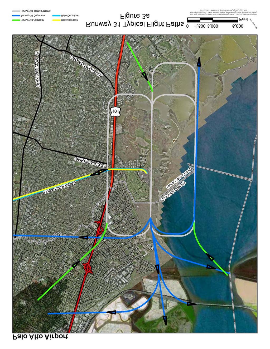
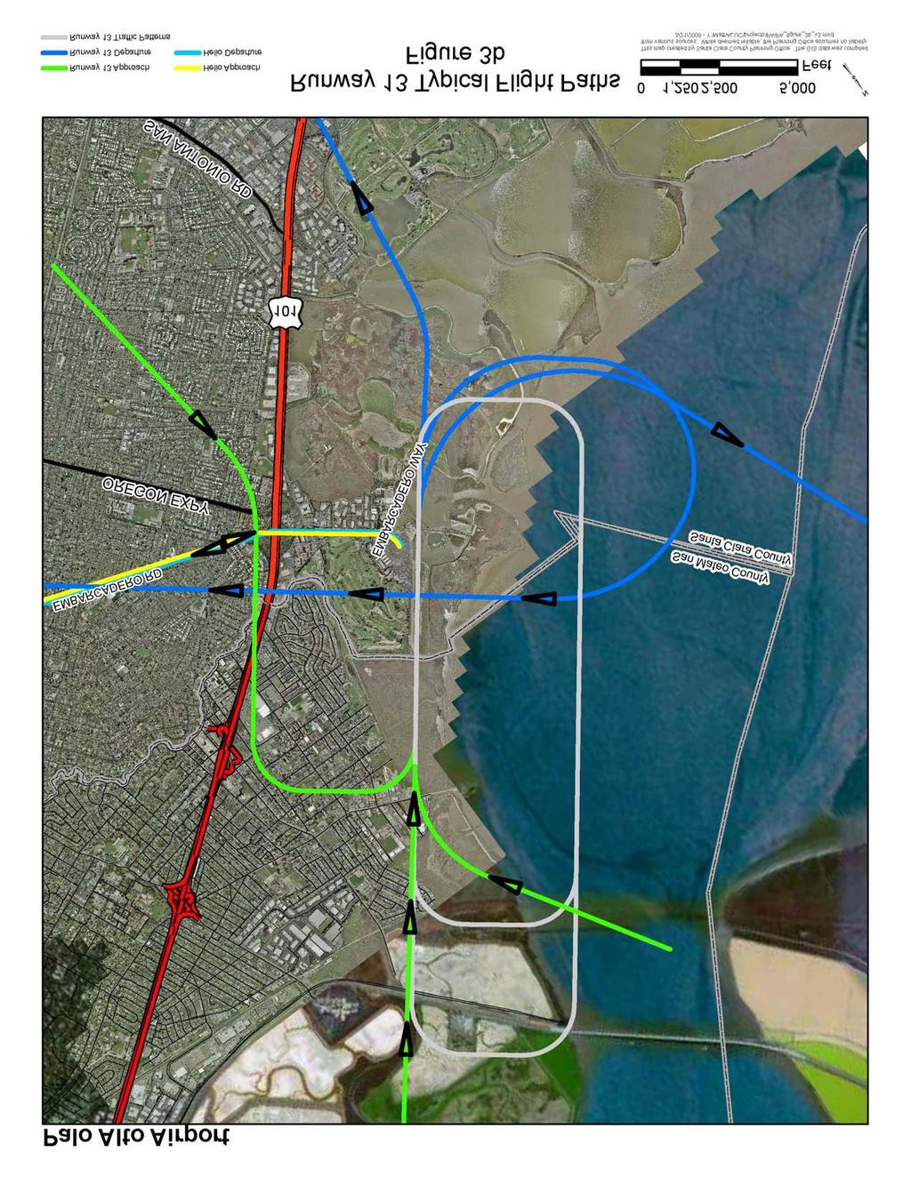
13 2.2.2 Future Airport Facilities Any change to the airport facilities would have to be approved by the City of Palo Alto. The current Airport Master Plan (AMP) identifies a potential increase of 29 aircraft hangars, which would result in an additional 40 aircraft based at the Airport. The AMP also recommends a new, relocated Helipad, an aircraft wash rack, a replacement General Aviation Terminal building and parking lot, reconfiguration of Taxiway G and relocated tiedowns. 2.3 AVIATION ACTIVITY The noise impact of an airport is a direct result of the number of aircraft operations at that airport and the types of those aircraft. Given this information, and some other factors such as flight tracks and the distribution of flight operations throughout the day and night, computer models can generate a representation of the noise contours around an airport. The generalized flight tracks for the airport are shown in Figure 3. The noise contours created by the computer model reflect the data provided to the program. Thus the activity data, both current and forecasted, needs to be as accurate as possible. The aviation activity data is taken from the November 2002 draft of the Airport Roles and Forecasts, Chapter 2 of the County Airports Master Plan (AMP) adopted by the Santa Clara County Board of Supervisors on November 19, 2002 and the HMMH Palo Alto Airport Noise Contour report dated February 24, The Noise Contour Report gives aircraft activity percentages and the AMP provides forecasts of aircraft operations at the Airport through the year As the CLUP is a 20-year planning document, the existing base year (2001) aviation activity was reviewed and updated aviation activity forecasts were prepared through the year A summary of the existing and forecast aviation activity is presented in Table 2-1 and discussed in the following paragraphs Based Aircraft The AMP forecasts that the number of based aircraft at Palo Alto will increase from 524 in 2001 to 613 by 2022 as shown in Table 2-1. The growth in forecast-based aircraft at the Airport is due in large part to the potential increase in tie downs and hangars planned for the Airport. The mix of aircraft based at the airport is not forecast to change appreciably through Aircraft Operations The number of annual aircraft operations at Palo Alto Airport, as presented in Table 2-1, is forecast to increase from an estimated 212,626 operations in the year 2002 to 227,509 operations by the year These data are taken from the recent Palo Alto Airport Master Plan. The AMP indicates that the mix of operations at the airport is not forecast to change appreciably through General Aviation Since no commercial passenger (air carrier) operations are forecast for the planning period, general aviation will continue to account for all of the operations at the Airport, increasing from an estimated 212,626 annual operations in 2002 to 227,509 annual operations by Local Operations. Local operations are performed by aircraft operating in the local traffic pattern and aircraft departing for, or arriving from, local practice areas. These operations include training operations by both aircraft based at the Airport and aircraft from other airports in nearby counties. The local operations include flight training, the activities of based aircraft pilots maintaining their landing skills and activities of itinerant aircraft pilots who come to practice landing at a different airport. Local operations are forecast to remain at about 60 percent of total general aviation aircraft operations over the forecast period and will continue to account for the larger number of general aviation operations at the airport. 2-5
14
15
16 Table 2-1 UPDATED AVIATION ACTIVITY FORECASTS Palo Alto Airport GENERAL AVIATION BASED AIRCRAFT Base Year 2001 Forecast Single-engine piston Single-engine turbine Multi-engine piston Multi-engine turbine Helicopter Other (Fanjet, quieter than Stage 3) Total based aircraft AIRCRAFT OPERATIONS General Aviation -Itinerant -Local Subtotal General Aviation Operations 74,539 _135, ,755 86, , ,364 87, , ,044 90, , ,240 90, , ,301 90, , ,749 Air Taxi Military Helicopter Total Operations 210, , , , , ,509 OPERATIONS PER BASED AIRCRAFT Source: Palo Alto Airport Master Plan, Airport Roles and Forecasts, HMMH Palo Alto Airport Noise Contour report and Airport Management 2-8
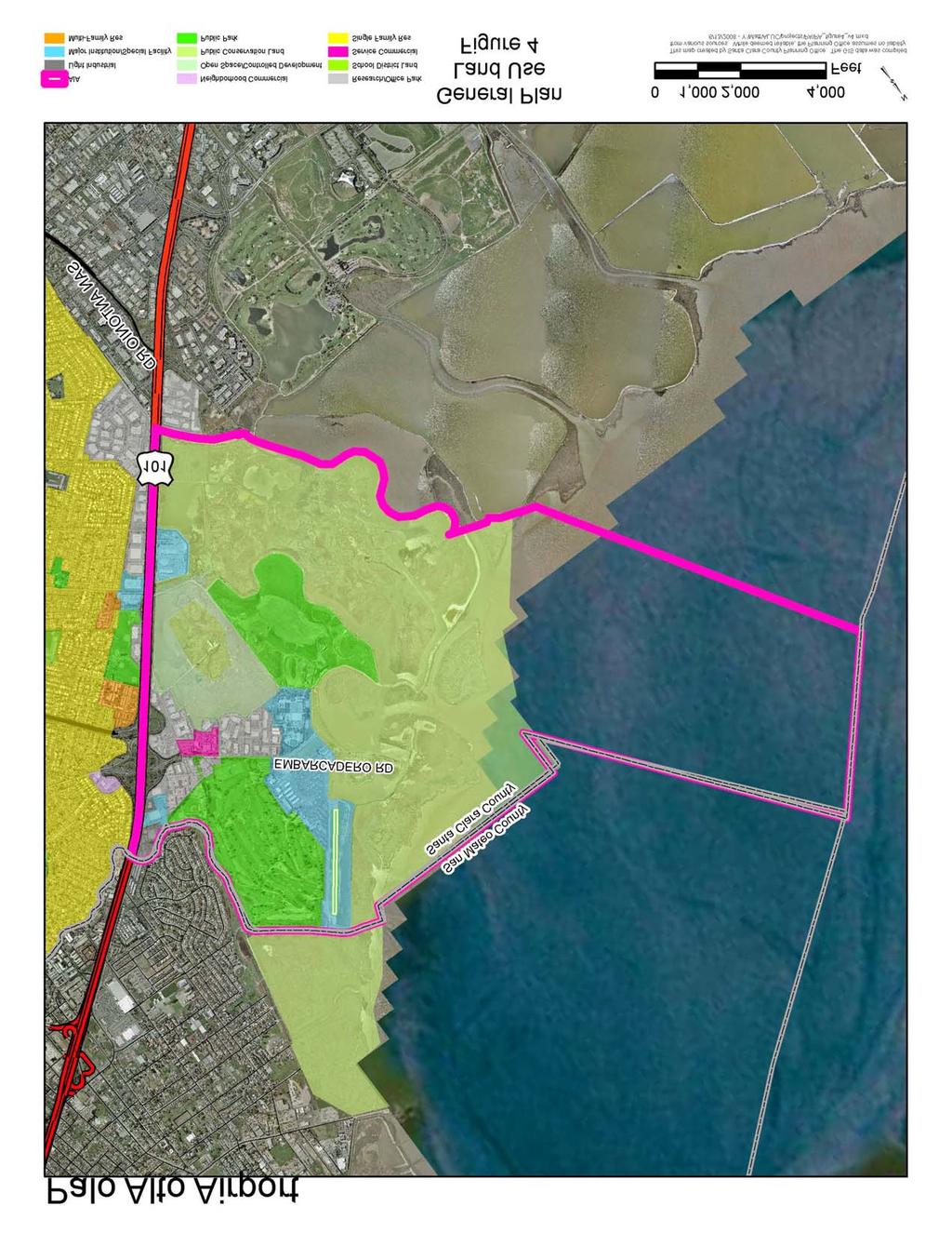
17 Itinerant Operations. Itinerant operations are conducted by aircraft that takeoff from one airport and land at another airport, or the reverse. They include the operations of aircraft based at the Airport and flights of other aircraft to and from the Airport. The itinerant operations at the Airport include aircraft based on the airport used for personal business, recreational activities and Angel Flights for medical services. Itinerant operations are forecast to remain at about 40 percent of total general aviation aircraft operations over the forecast period and will continue to account for the smaller number of aircraft operations at the airport Air Taxi In 2001 there were 80 Air Taxi operations at the Airport. In 2002 there were 11 Air Taxi operations. In 2006 there were nearly Air taxi operations include the unscheduled "for hire" operations carrying passengers and cargo to and from the area including any operations by bank couriers or other small package carriers. Based on discussions with persons knowledgeable of the Airport and its activities, Air Taxi operations are forecast to increase to 1500 annual operations in the year Military Based on discussions with persons knowledgeable of the Airport and its activities, there were no military operations in The current runway is not suitable for fixed-wing military aircraft. Current military aircraft require runways of greater length than those at the Airport. Military helicopter operations are not expected to contribute in a significant manner to the number of annual airport operations through Helicopter In past years, there were a number of helicopter operations, mostly associated with medivac of patients destine for Stanford Hospital. Stanford Hospital now has its own helipad and the number of helicopter operations has dropped from prior years to refueling stops only. The number of helicopter operations is estimated to be 260 per year and is included in the airport noise calculations. 2.4 AIRPORT ENVIRONS Figure 4 presents the land use designations within the Airport environs based on the current Santa Clara County 2002 General Plan. The City of Palo Alto is adjacent to and southwest of the Airport and the City of East Palo Alto, located in San Mateo County lies to the northwest of the Airport. The predominant land uses in the Airport environs are wetlands, bay waters, golf driving range, commercial and limited residential. 2-9
18
19 Section 3 3 LAND USE COMPATIBILITY GUIDELINES 3.1 OVERVIEW Land use compatibility policies and standards are based on community values, sound technical knowledge, and acceptable analytical methods. These policies and compatibility criteria form the basis for evaluating existing land use compatibility and provide the foundation for the Santa Clara County Airport Land Use Commission (ALUC) policies. These standards focus on the three areas of ALUC responsibility including aircraft noise, the control of objects in navigable airspace, and the safety of persons on the ground and in aircraft. These compatibility criteria are contained in relevant State and Federal statutes and regulations and are discussed in this section. Federal, State and other local agencies have developed and published guidelines for airport land use compatibility planning. Unfortunately, no civilian or military authority has established regulations or statutes that specify a single methodology for mitigating the incompatibilities between an airport and its environs, nor have such incompatibilities been adequately defined. The enabling legislation for the Santa Clara County Airport Land Use Commission offers some guidance while directing the Commission to provide for the orderly growth of the airports and the areas surrounding the airports, and to safeguard the general welfare of the inhabitants within the vicinity of the airports and the public in general. The legislation further enables the Commission to develop height restrictions on structures, to specify the use of land, to determine building standards, including noise insulation, and to assist local agencies in ensuring compatible land uses in the vicinity of the airports to the extent that the land in the vicinity of the airports is not already devoted to incompatible uses. The Commission is also empowered to coordinate planning at the State, regional and local levels so as to provide for the orderly development of air transportation, while at the same time protecting the public health, safety, and welfare. 3.2 LAND USE COMPATIBILITY CRITERIA The principal source for airport land use compatibility planning is the January 2002 California Airport Land Use Planning Handbook (2002 Handbook) published by the California Department of Transportation, Division of Aeronautics (Caltrans). The 2002 Handbook provides guidelines for formulating compatibility criteria and policies for preparing Comprehensive Land Use Plans (CLUPs). Noise and safety compatibility concepts and issues are presented, and copies of relevant legislation and examples of mitigation measures, such as model noise and avigation easements are included. The 2002 Handbook is available for review at and at the Santa Clara County Planning Department office. Note that a local agency is not precluded from establishing land use policies and guidelines that are more restrictive than those described in this CLUP. 3.3 NOISE RESTRICTION AREA Airport noise affects many communities. At certain levels, airport noise can interfere with sleep, conversation, or relaxation. It also may disrupt school and work activities. At even higher levels, airport noise may make outdoor activities impossible and may begin to raise health concerns with respect to hearing loss and stress-related problems. However, hearing damage from airport noise may not be a problem for nearby neighbors because noise levels are simply not of sufficient intensity to cause such damage. An exception to this is the exposure a ground crew member receives during the handling of a jet aircraft. Similarly, medical studies are inconclusive on a cause-and-effect relationship for non-auditory health concerns near airport. A more general conclusion is that noise may have an additive effect for some people with anxieties, ulcers, and tension illness. The amount of annoyance that aircraft noise creates among people living and working in the vicinity of an airport varies on an individual basis. Studies show that a certain percentage of people will continue to be annoyed by aircraft noise at any given noise level, regardless of how low that aircraft noise level may be. All levels of government share responsibility for addressing the airport noise issue. The Federal government establishes noise standards for aircraft as published in Federal Aviation Regulations (FAR) Part 36, Noise Standards: Aircraft Type and Airworthiness Certification, and conducts research on noise 3-1
20 abatement techniques and noise compatibility. The preparation of a special airport noise study under the provisions of FAR Part 150, Airport Noise Compatibility Planning, provides technical assistance to the airport operator in planning and implementing a noise compatibility program. The State of California also prescribes noise standards for all airports as defined in Title 21, Airport Noise Standards, of the California Code of Regulations, and sets noise insulation standards for residential structures as defined in Title 24, California Building Standards Code, of the California Building Standards Commission. The airport operator may develop airport noise control programs and enact operational restrictions to control and reduce noise levels in the community. Finally, local governments have the responsibility to limit the exposure of the population to excessive airport noise levels through the land use planning and zoning process Airport Noise Descriptors To adequately address the airport noise issue, local governments need a standard way to measure and describe airport noise and establish land use compatibility guidelines. The County of Santa Clara has identified DNL and CNEL as being equivalent measures of noise. Relative to aviation, it is common to use the Community Noise Equivalent Level (CNEL) for determining land use compatibility in the community environment. The Community Noise Equivalent Level (CNEL) descriptor is a method of averaging single-event noise levels over a typical 24-hour day and applying penalties to noise events occurring during the evening (7 p.m. to 10 p.m.) and night (10 p.m. to 7 a.m.) hours. CNEL is usually defined in terms of average annual conditions, so that the CNEL measured on a given day may be either less than or greater than the annual average. The State of California uses the CNEL descriptor to describe land use compatibility with respect to aircraft noise exposures. CNEL is the noise descriptor standard defined in Title 21 of the California Code of Regulations, Airport Noise Standards, and the standard specified for evaluation of exterior and interior noise impacts in Title 24 of the California Building Standards Commission, California Building Standards Code. The CNEL is identified as one of two noise descriptors used in the preparation of a noise element of a general plan according to guidelines established by the Office of Noise Control, California Department of Health Services (now documented as General Plan Guidelines, Appendix A). The Federal Aviation Administration (FAA) recognizes the CNEL as essentially equivalent to the Yearly Day-Night Average Sound Level (DNL), which is the basis for FAA recommendations for land use compatibility with respect to aircraft noise described in FAR Part 150, Airport Noise Compatibility Planning. The decibel (db) is the unit of measurement for the magnitude of a sound. A decibel is equal to the logarithm of the ratio of the intensity of the sound to the intensity of an arbitrarily chosen standard sound, specifically a sound just barely audible to an unimpaired human ear (e.g., 55, 60, 65, 70 and 75 db) Land Use Compatibility Standards California Land use compatibility guidelines for airport noise are included in the 2002 Handbook. Amendments to the law enacted in October 1994 mandate the use of these guidelines in the preparation of airport land use plans. These guidelines were originally developed in 1983 after considering State Office of Noise Control (ONC), FAA, and U.S. Department of Housing and Urban Development (HUD) guidelines together with a review of available airport land use plans. Existing Federal and State laws were reviewed as part of the updated 2002 Handbook. The State ONC criteria established the 55 db CNEL as a residential threshold value to distinguish normally acceptable from conditionally acceptable situations. The Caltrans guidelines for land use compatibility standards extend below the Federal 65 db CNEL, as the Federal threshold does not sufficiently explain the annoyance area surrounding general aviation airports. The frequency of operations from some airports, visibility of aircraft at low altitudes and typically lower background noise levels around many general aviation airports are all believed to create a heightened awareness of general aviation activity and potential for annoyance outside of the 65 db CNEL contour. 3-2
21 At and above the 60 db CNEL level, the California Building Code, Section 1208A.8.3 requires an acoustical analysis of proposed residential structures, other than detached single-family dwellings, to achieve an indoor noise level of 45 db CNEL. The noise attenuating properties of existing types of construction were considered in setting state standards. Typical wood frame construction with drywall interiors provides noise reduction of between 15 and 20 db. Thus, residential units exposed to outdoors noise in the range between 60 and 65 db CNEL can be attenuated to achieve the 45 db CNEL level indoors when built using normal standards of construction. The 2002 Handbook (see Appendix B herein) urges ALUCs to be conservative when establishing noise contours Land Use Compatibility Standards - Santa Clara County In the Noise Element of the 1994 Santa Clara County General Plan, the County identified 55 db DNL as the normally acceptable standard for residential uses. Above 55 db DNL, residential uses are conditionally acceptable, however the noise exposure is great enough to be of some concern Land Use Compatibility Standards City of Palo Alto In the Natural Environment element of the 1998 Palo Alto Comprehensive Plan, the City specifies a maximum interior noise level limit of 45 db Ldn (equilivent to CNEL) and 50 db SENL for single family residences and multiple family dwellings, and a maximum exterior noise level guideline of 60 Ldn for residences, hotels, motels, schools, libraries, museums, hospitals, meeting halls, personal care, and churches. Specified land uses in areas above these exterior noise levels are permitted after an acoustical analysis of the amount of attenuation necessary to maintain an indoor level of Ldn <=45 db. Outdoor areas intended for residential recreational use with a noise level above 60 db LDN are required to reduce noise levels as close to 60 db Ldn as feasable through project design Palo Alto Airport Noise Contours An analysis of annual aircraft operations and related noise levels for Palo Alto Airport was made to prepare CNEL noise exposure maps for this CLUP using current and forecast aircraft operations based on the existing runway configuration. The ALUC has elected to adopt the most conservative (largest) contours from this study for the purposes of this CLUP. The Federal Aviation Administration's (FAA) Integrated Noise Model (INM) Version 6.1 was used to prepare CNEL noise exposure maps based on the FAA aircraft noise level database and airport operational factors described below. The INM software was developed by the FAA and represents the Federally sanctioned and preferred method for analyzing aircraft noise exposure Aircraft Operations Aircraft operational factors that can significantly affect overall noise levels as described by CNEL include the aircraft fleet mix, the number of daily operations and the time of day when aircraft operations occur. Runway use factors also significantly influence CNEL values. Trip length can affect aircraft single-event noise levels. An aircraft that is making a local flight may carry less fuel and fewer passengers than that for a long flight and therefore make less noise on departure. The INM software applies corrections to air carrier aircraft takeoff profiles to account for these differences, but makes no corrections to general aviation aircraft takeoff profiles. Aircraft operational assumptions for the Airport were based upon analyses of airport activity provided by the FAA tower and Airport Management. These assumptions are summarized in Tables 3-1 and 3-2. Twin-engine turbine powered business aircraft are represented by the INM CNA441; twin-engine piston aircraft are represented by the INM BEC58P designation. Single-engine turbine powered aircraft are represented by the INM CNA206 and CNA20T designations. The high-performance single-engine propeller aircraft such as the Cessna 210 are represented by the INM GASEPV designation and standard single-engine propeller aircraft are represented by the INM GASEPF and CNA172 designations. Helicopters are represented by the INM B222 designation and are included in the noise calculations. 3-3
22 Table 3-1 AIRPORT CONFIGURATION AND RUNWAY USE Palo Alto Airport 2022 Airport Configuration Runway Configuration: Field Elevation: (Runway High Point) Runway Use: 4 feet MSL Runway 31 90% Runway 13 10% Temporal Distribution of Runway Operations Percentage of Use Aircraft Class Day 7 a.m. to 7 p.m. Evening 7 p.m. To 10 p.m. Night 10 p.m. to 7 a.m. Takeoff and Landing Fixed Wing Aircraft, All 82.5% 15% 2.5% Helicopter 75.0% 20% 5.0% Source: HMMH Palo Alto Airport Noise Contour report and Airport Management 3-4
23 Table 3-2 ANNUAL AIRCRAFT OPERATIONS Palo Alto Airport 2022 Generalized Aircraft Type Year 2022 Twin-Engine Turboprop (CNA441) 3,562 Twin-Engine Piston (BEC58P) 18,522 Single-Engine, Business Turboprop (CNA20T) 4,987 Single-Engine, Turboprop (CNA206) 45,592 Single-Engine Piston, High Performance (GASEPV) 45,592 Single-Engine Piston, Standard (CNA172) 39,181 Single-Engine Piston, Trainer (GASEPF) 69,813 Helicopters (B222) 260 Gliders 0 Total 227,
24 Descriptions of aircraft flight tracks were developed for use in the INM through discussions with Airport Management and review of the assumptions used for previous descriptions of aircraft operations at the Airport. Based on these data, generalized flight tracks were prepared for use in the noise modeling process to describe areas with a concentration of aircraft overflights. It is recognized that variations in flight paths occur at the Airport and that the tracks used for this analysis are a general representation of those flight tracks CNEL Noise Exposure Contours The Integrated Noise Model (INM) Version 6.1 was used to prepare CNEL noise exposure contours for the Airport based on the aircraft noise level and operational factors described in the previous sections. User inputs to the INM include the following: Airport altitude and mean temperature Runway configuration Aircraft flight track definition Aircraft stage length (not applicable to Palo Alto Airport) Aircraft departure and approach profiles Aircraft traffic volume and fleet mix Flight track utilization by aircraft types The INM database includes aircraft performance parameters and noise level data for numerous commercial, military and general aviation aircraft classes. When the user specifies a particular aircraft class from the INM database, the model automatically provides the necessary inputs concerning aircraft power settings, speed, departure profile, and noise levels. INM default values were used for all fixed-wing aircraft types. After the model had been prepared for the various aircraft classes, INM input files were created containing the number of operations by aircraft class, time of day and flight track for annual average day aircraft operations and future operations. From these data, the INM produces lines of equal noise levels, i.e. noise contours. The location of these noise contours become less precise with distance from the runway since aircraft do not follow each flight track exactly as defined in the model. However, they are accurate enough to indicate general areas of likely community response to noise generated by aircraft activity and serve as the basis for land use compatibility determinations Impacts on Land Use The 60, 65, 70 and 75 db CNEL noise contours based on the forecast aircraft operations are illustrated on Figure 5 and discussed below db CNEL Noise Level The 75 db CNEL aircraft noise contour is completely contained within the Airport boundaries db CNEL Noise Level The 70 db CNEL aircraft noise contour is generally contained within the Airport boundaries except for the northwest end of the airport, where it extends about 1900 feet beyond the airport boundary on the extended runway centerline over into the Palo Alto Baylands Nature Preserve in San Mateo County db CNEL Noise Level The 65 db CNEL aircraft noise contour extends beyond the airport boundaries in all directions but is over the Palo Alto Municipal Golf Course, and the Palo Alto Baylands Nature Preserve in San Mateo County. 3-6
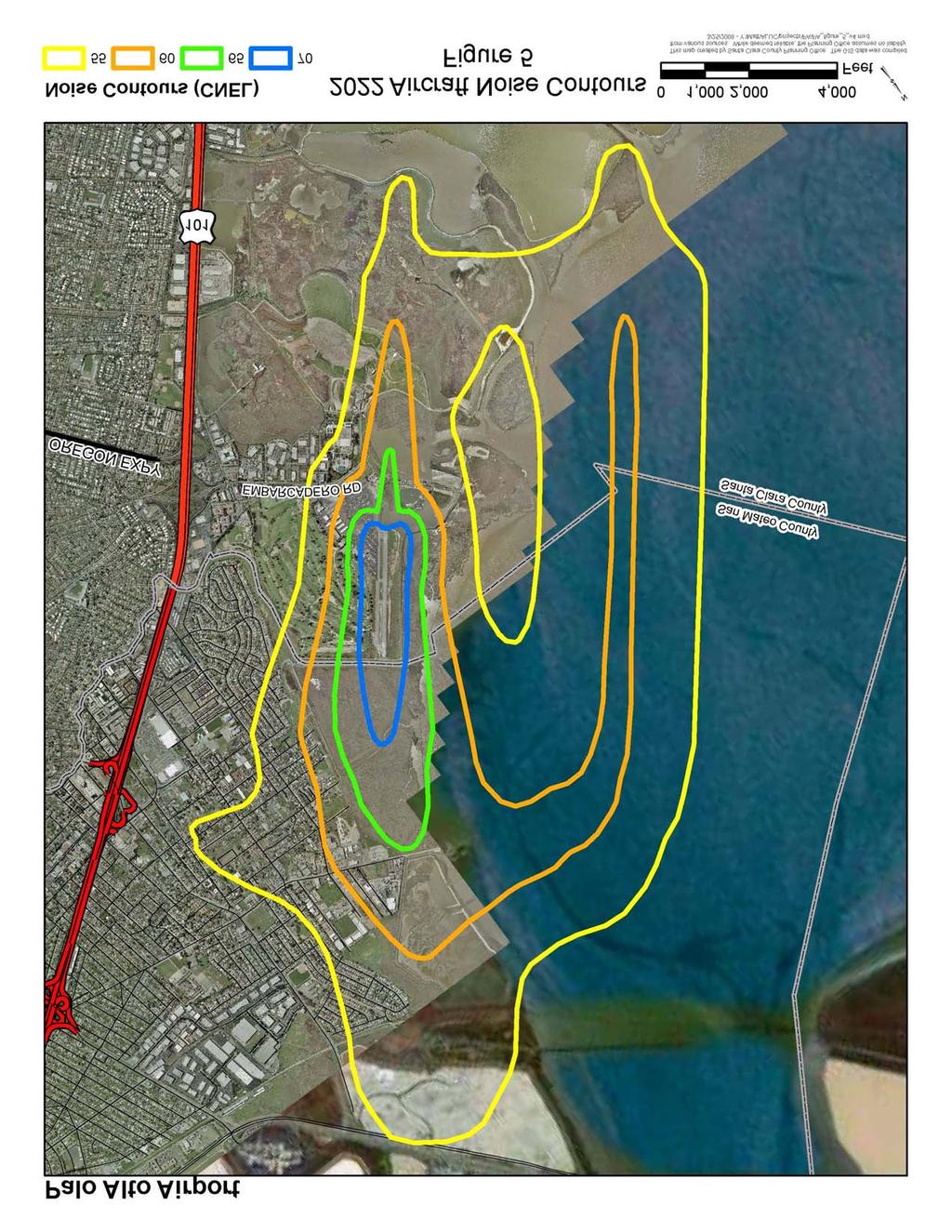
25
26 db CNEL Noise Level The 60 db CNEL aircraft noise contour extends beyond the airport boundaries in all directions and is over the Palo Alto Baylands Nature Preserve and the Palo Alto Municipal Golf Course, except for a portion to the west and northwest that extends about 500 feet west of the Grant Boundary and out along the extended runway center line to about 2300 feet northwest of Bay Road in East Palo Alto in San Mateo County. 3.4 HEIGHT RESTRICTION AREA Airport vicinity height limitations are required to protect the public safety, health, and welfare by ensuring that aircraft can safely fly in the airspace around an airport. This protects both those in the aircraft and those on the ground who could be injured in the event of an accident. In addition, height limitations are required to protect the operational capability of airports, thus preserving an important part of National and State aviation transportation systems. Federal Aviation Regulations (FAR) Part 77, Objects Affecting Navigable Airspace, establishes imaginary surfaces for airports and runways as a means to identify objects that are obstructions to air navigation. Each surface is defined as a slope ratio or at a certain altitude above the airport elevation. FAA uses FAR Part 77 obstructions standards as elevations above which structures may constitute a safety problem. Any penetrations of the FAR Part 77 surface are subject to review on a case-by-case basis. If a safety problem is found to exist, FAA may issue a determination of a hazard to air navigation. FAA does not have the authority to prevent the encroachment, however California law can prevent the encroachment if the FAA has made a determination of a hazard to air navigation. The local jurisdiction can establish and enforce height restrictions. The dimensions of the imaginary surfaces vary depending on the type of approach to a particular runway as illustrated on Figure 6 for the Airport based on the ultimate dimensions shown on the Airport Layout Plan. Nonprecision Instrument-Approach runways generally have larger surfaces and flatter approach slopes than visual runways. Table 3-3 tabulates the imaginary surfaces described below Primary Surface A surface longitudinally centered along a runway, and extending 200 feet beyond the end of each instrument runway. For Runway the width is 500 feet and the primary surface extends 200 feet beyond the ends of the runway Approach Surface A surface longitudinally centered on the extended runway centerline, extending outward and upward from each end of the primary surface. An Approach Surface is applied to each end of each runway based upon the type of approach available or planned for that runway end. The inner edge of the Approach Surface is the same width as the Primary Surface and it extends for a length of 5000 feet at a slope of 20:1. Runway 31 Approach Surface has a width of 2000 feet at the outer end and Runway 13 Approach Surface has a width of 1250 feet at the outer end Transitional Surface A surface extending outward and upward from the sides of the Primary Surface and from the sides of the Approach Surfaces at a slope of 7 to Horizontal Surface A horizontal plane 150 feet above the established airport elevation (the highest point of an airport's usable landing area measured in feet above mean sea level), the perimeter of which is constructed by swinging arcs 5,000 feet out for Runway 31-13, from the center of each end of the Primary Surface of each runway and connecting the arcs with tangent lines. 3-8
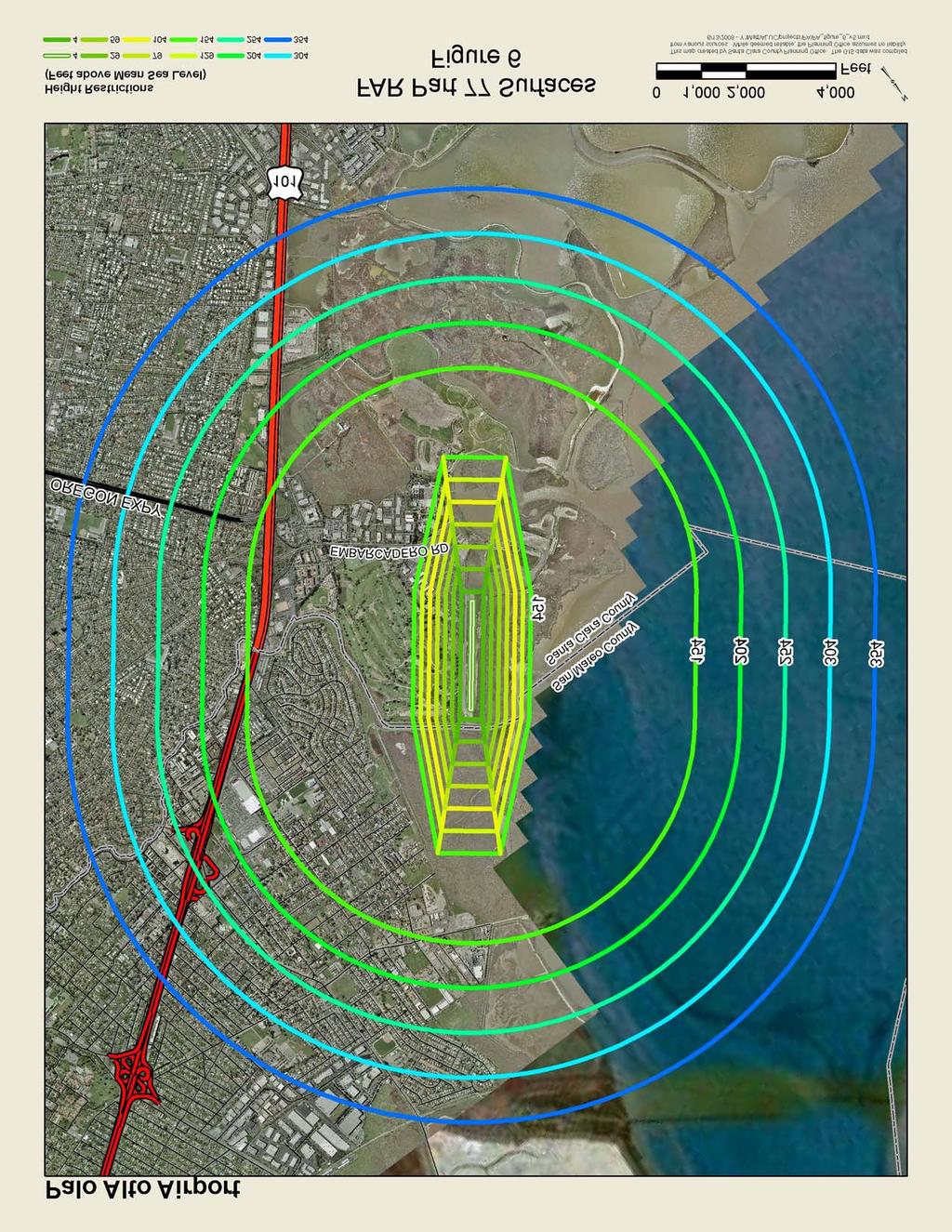
27
28 Table 3-3 FAR PART 77 DIMENSIONS Palo Alto Airport Runway Runway Type Nonprecision Visual Primary Surface Length (feet) 2,843 2,843 Width (feet) Approach Surface Slope 20:1 20:1 Length (feet) 5,000 5,000 Inner Width Outer Width 2,000 1,250 Transitional Surface Slope 7:1 7:1 Horizontal Surface End Radius (feet) 5,000 5,000 Elevation (feet MSL) Conical Surface Slope 20:1 20:1 Width (feet) 4,000 4,000 Source: Federal Aviation Regulations, Part
29 3.4.5 Conical Surface A surface extending outward and upward from the periphery of the Horizontal Surface at a slope of 20 to 1 for a horizontal distance of 4,000 feet Summary Where imaginary surfaces overlap, such as in the case where the Approach Surface penetrates and continues upward and outward from the Horizontal Surface, the lowest surface is used to determine whether or not an object would be an obstruction to air navigation. Any proposed new construction or expansion of existing structures that would penetrate any of the FAR Part 77 imaginary surfaces of the Airport is considered an incompatible land use, unless either the FAA has determined that the proposed structure does not constitute a hazard to air navigation or the Caltrans Aeronautics Program has issued a permit allowing construction of the proposed structure. The FAA has established minimum standards for the determination of hazards or obstructions to aviation. The FAA permits local agencies such as the ALUC to establish more restrictive criteria for determining if the height of a structure creates a safety hazard to aircraft operations. A determination by the FAA or Caltrans that a project does not constitute a hazard to air navigation does not limit the ALUC from determining that a project may be inconsistent under the policies of this CLUP. 3.5 SAFETY RESTRICTION AREA Safety of people on the ground and in the air and the protection of property from airport-related hazards are among the responsibilities of the Airport Land Use Commission. The 2002 Handbook presents guidelines for the establishment of airport safety areas in addition to those established by the FAA. Airport safety zones are established to minimize the number of people exposed to potential aircraft accidents in the vicinity of the Airport by imposing density and use limitations within these zones. Figure 7 illustrates the airport safety zones for Runway at the Airport. The safety zones are related to runway length and expected use. The safety zones shown on Figure 7 are based on a runway length of 2443 feet. Aircraft flight tracks are shown on Figure 3. Safety zones shown in San Mateo County are reference only. In addition, the survivability of aircraft occupants in the event of an emergency landing has been shown to increase significantly if the aircraft is able to reach the ground under control of the pilot. As a result, open area requirements are established for the safety zones in addition to density and use requirements. Exposure to potential aircraft accidents diminishes with distance from the airport runways. The safety zones shown below are in descending order of exposure to potential aircraft accidents, with the Runway Protection Zone (RPZ) having the highest exposure followed by the Inner Safety Zone (ISZ), Turning Safety Zone (TSZ), Outer Safety Zone (OSZ) and Sideline Safety Zone (SSZ), with the Traffic Pattern Zone (TPZ) having the lowest level of exposure. At airports with displaced runway thresholds, a choice exists to use either the runway threshold (end of pavement) or the displaced threshold to determine the location of the safety zones. This CLUP uses the threshold adopted by the Airport and the FAA for positioning the FAA RPZs, as depicted on the FAA approved Airport Layout Plan, as the basis for positioning the ALUC safety zones. At this airport both RPZs are based on the displaced thresholds and thus the ALUC safety zones are positioned accordingly. The safety zones defined for the Airport are based on the 2002 Handbook guidelines for an airport having a general aviation runway less than 4,000 feet in length. Symmetrical turning zones were used due to some air traffic operating in a traffic pattern on the west side of the airport Safety zones are exclusive in their coverage, and do not overlay each other. Thus land in the RPZ is only in the RPZ, and is not also in the ISZ or TSZ. The order of precedence is, from highest to lowest: RPZ, ISZ, TSZ, OSZ, SSZ and TPZ. If a development project spans more than one safety zone, each part of the project must meet the requirements for the safety zone in which the land for that portion of the project is located. Thus a single building that extends over two safety zones may have differing height and densityof-use requirements for the two parts of the same physical structure. The following safety zones apply to Palo Alto Airport based on guidelines provided in the 2002 Handbook: 3-11
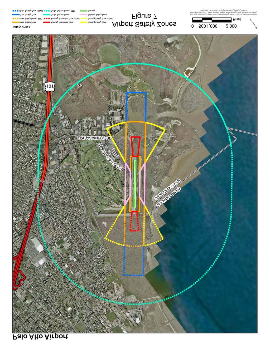
30
31 3.5.1 Runway Protection Zone The function of the Runway Protection Zone (RPZ) is to enhance the protection of people and property on the ground and aircraft occupants. RPZs should be clear of all objects, structures and activities. At this airport the RPZ as adopted by the airport and the FAA, begins 200 feet out from the runway thresholds. It is a trapezoidal area centered on the extended runway centerline. The size is related to the expected aircraft use and the visibility minimums for that particular runway. Runway 31-13: The RPZ for Runway 31 is non-standard but FAA approved at 1,000 feet long, with an inner width of 250 feet and an outer width of 450 feet. The RPZ for Runway 13 is 1,000 feet long, with an inner width of 250 feet and an outer width of 450 feet Turning Sector Defined Some of the safety zones are bounded by a geometric feature defined as a Turning Sector. This feature is constructed as follows: Each runway end has a sector. The radius of these sectors is 3000 ft with the center point located 1000 ft along the runway centerline from the runway threshold towards the opposite end of the runway. The arc for the sector is swung centered on the extended runway centerline. The interior angle of the sector is 30 degrees on each side of the extended runway centerline, or 60 degrees wide. The Turning Sector is defined as the outside bounds of the feature constructed above. There is one Turning Sector for each end of the runway system Inner Safety Zone The Inner Safety Zone (ISZ) is located within the Turning Sector boundary described above. The ISZ represents the approach and departure corridors that have the second highest level of exposure to potential aircraft accidents. The ISZ is centered on the runway centerline starting at the apex of the Turning Sector boundary and extends to the outer arc of the Turning Sector boundary. The length of the runway determines the dimensions. The ISZ for Runway 31 and 13 is an area 1,000 feet wide, centered between the runways and contained within the Turning Sector. The Inner Safety Zone excludes the RPZ and the Primary Surface Turning Safety Zone The Turning Safety Zone (TSZ) represents the approach and departure areas that have the third highest level of exposure to potential aircraft accidents. The Turning Safety Zones are defined below. The TSZs for Runways 31 and 13 are the four areas within the Turning Sectors outside of the ISZ. The Turning Safety Zone areas do not include the RPZ or the ISZ Outer Safety Zone The Outer Safety Zone (OSZ) is an area centered on the extended runway centerline starting at the outer end of the Turning Safety Zone (TSZ) and extending away from the runway end. The length of the runway determines the dimensions. The OSZ for each end of the runways is a rectangular area 1000 feet wide and 1500 feet long centered on the extended runway centerline, starting at the outer edge of the TSZ and extending away from the runway threshold. 3-13
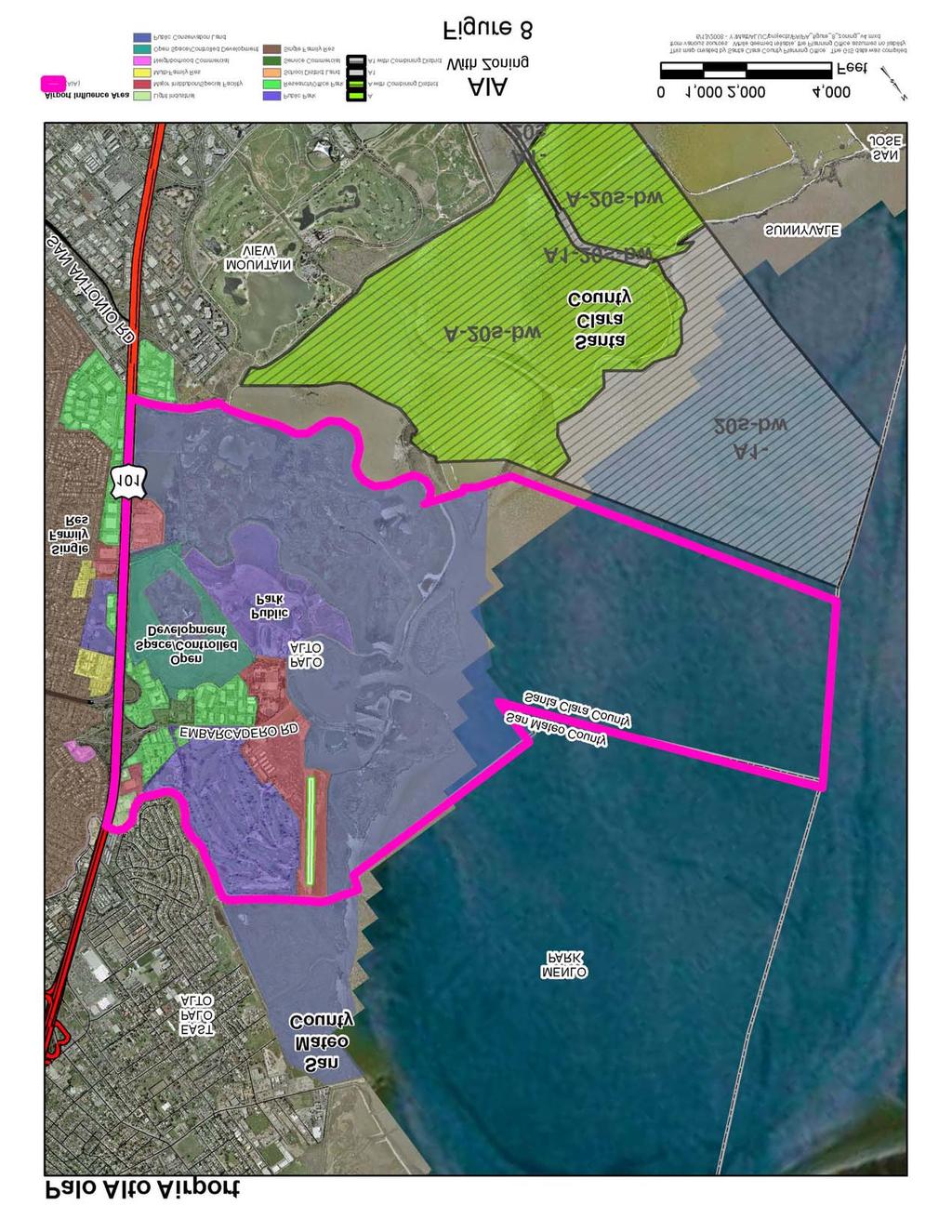
32 3.5.6 Sideline Safety Zone The Sideline Safety Zone (SSZ) is an area along side and parallel to the runway. Aircraft do not normally overfly this area, except aircraft losing directional control on takeoff (especially twin-engine aircraft). The SSZ for Runway is 1000 feet wide centered on the runway centerline and extending along the runway to intercept the Turning Sector boundaries Traffic Pattern Zone The Traffic Pattern Zone (TPZ) is that portion of the airport area routinely overflown by aircraft operating in the airport traffic pattern. The potential for aircraft accidents is relatively low and the need for land use restrictions is minimal. The TPZ excludes all other zones described above. The perimeter of the TPZ is constructed by swinging arcs of 5,000-foot radius for Runways 31 and 13 from a point 200 feet out from the runway pavement end on the extended centerline and connecting the arcs with a line tangent to these arcs. 3.6 OVERFLIGHT RESTRICTION AREA All areas within the Airport Influence Area (AIA) should be regarded as potentially subject to aircraft overflights. Although sensitivity to aircraft overflights will vary from one person to another, overflight sensitivity is particularly important within residential land uses and certain agricultural uses (open-air turkey farming, etc.). 3.7 AIRPORT INFLUENCE AREA The Airport Influence Area (AIA) is a composite of the areas surrounding the Airport that are affected by noise, height, and safety considerations. The AIA is defined as a feature-based boundary around the Airport within which all development projects must be evaluated by local agencies to determine how the Airport Comprehensive Land Use Plan may impact the proposed development. This evaluation is to determine that the development meets the conditions specified for height restrictions, and noise and safety protection to the public. [A.B. 332 (Stats. 2003) to be codified in Public Utilities Code (b)]. The Airport Influence Area (Figure 8) is defined as that portion of Palo Alto east of the Bayshore Freeway bounded by U.S. Highway 101 to San Francisquito Creek along the Palo Alto City boundary to Charleston Slough to Barron Creek back to U.S. Highway 101. In addition, for structures (including antennae) with a height of 500 feet or greater above ground level, the AIA is defined as the entire county. The compatibility of land uses within the AIA should be preserved to the maximum extent feasible with particular emphasis on the preservation of existing agricultural and open space uses. The conversion of land from existing or planned agricultural, industrial, or commercial use to residential uses should be the subject of careful consideration of the potential impacts of aircraft overflights. 3-14
33
Notice of Extended Comment Period for an Intent to Adopt a Negative Declaration
 County of Santa Clara Department of Planning and Development Planning Office County Government Center, East Wing, 7 th Floor 70 West Hedding Street San Jose, California 95110-1705 (408) 299-5770 FAX (408)
STAFF REPORT. Airport Land Use Consistency Determination Betteravia Plaza. MEETING DATE: January 21, 2016 AGENDA ITEM: 8D
 STAFF REPORT SUBJECT: Airport Land Use Consistency Determination Betteravia Plaza MEETING DATE: AGENDA ITEM: 8D STAFF CONTACT: Andrew Orfila RECOMMENDATION: Adopt findings for the Betteravia Plaza project
The following criteria shall be applied within the boundaries of the AO District:
 Sec. 419 (a) Purpose AIRPORT OVERLAY DISTRICT (AO) The purpose of the Airport Overlay District is to regulate and restrict the height of structures, objects, or natural growth, regulate the locations of
COMPREHENSIVE LAND USE PLAN SANTA CLARA COUNTY NORMAN Y. MINETA SAN JOSE INTERNATIONAL AIRPORT
 COMPREHENSIVE LAND USE PLAN SANTA CLARA COUNTY NORMAN Y. MINETA SAN JOSE INTERNATIONAL AIRPORT Adopted by SANTA CLARA COUNTY AIRPORT LAND USE COMMISSION San Jose, California May 25, 2011 Amended 11/16/2016
Appendix C AIRPORT LAYOUT PLANS
 Appendix C AIRPORT LAYOUT PLANS Appendix C AIRPORT LAYOUT PLANS Airport Master Plan Santa Barbara Airport As part of this Airport Master Plan, the Federal Aviation Administration (FAA) requires the development
STAFF REPORT. Airport Land Use Plan Consistency Review: Old Town Village Mixed Use Project City of Goleta. MEETING DATE: June 18, 2015 AGENDA ITEM: 5M
 STAFF REPORT SUBJECT: Airport Land Use Plan Consistency Review: Old Town Village Mixed Use Project City of Goleta MEETING DATE: AGENDA ITEM: 5M STAFF CONTACT: Peter Imhof, Andrew Orfila RECOMMENDATION:
Chapter Six ALP Drawings. Tacoma Narrows Airport. Master Plan Update
 Chapter Six ALP Drawings Master Plan Update The master planning process for the (Airport) has evolved through efforts in the previous chapters to analyze future aviation demand, establish airside and landside
APPENDIX K LAND USE. Charles M. Schulz - Sonoma County Airport Draft Environmental Impact Report July 2011 K-1
 APPENDIX K LAND USE Charles M. Schulz - Sonoma County Airport Draft Environmental Impact Report July 2011 K-1 Appendix K Land Use THIS PAGE INTENTIONALLY LEFT BLANK Charles M. Schulz - Sonoma County Airport
STAFF REPORT. Airport Land Use Plan Consistency Review: Santa Barbara Airport Master Plan. MEETING DATE: November 19, 2015 AGENDA ITEM: 7D
 STAFF REPORT SUBJECT: Airport Land Use Plan Consistency Review: Santa Barbara Airport Master Plan MEETING DATE: AGENDA ITEM: 7D STAFF CONTACT: Peter Imhof, Andrew Orfila RECOMMENDATION: Adopt findings
CHAPTER 6 NOISE EXPOSURE
 CHAPTER 6 NOISE EXPOSURE FAA requires that the NEM submitted for review represent the aircraft noise exposure for the year of submittal (in this case 2008) and for a future year (2013 for OSUA). However,
Comparison Between Old and New ALUC Plans
 A P P E N I X H Comparison Between Old and New ALUC Plans OVERVIEW This Placer County Airport Land Use Compatibility Plan (ALUCP) sets forth land use compatibility criteria for the environs of Auburn Municipal,
ORDINANCE NO. _2013-
 ORDINANCE NO. _2013- AN ORDINANCE OF THE TOWNSHIP OF CONEWAGO, DAUPHIN COUNTY, PENNSYLVANIA, PROVIDING FOR AIRPORT ZONING REGULATIONS WITHIN THE AIRPORT ZONING OVERLAY DISTRICT CREATED BY THIS ORDINANCE
Background Data: Blue Canyon Airport and Environs
 5 Background Data: and Environs INTRODUCTION serves as an important emergency landing field amid mountainous terrain. The airport has existed on the site since the 1930s or 40s. The facility was operated
FACILITY REQUIREMENTS SUMMARY OF KEY ISSUES OVERVIEW
 FACILITY REQUIREMENTS SUMMARY OF KEY ISSUES OVERVIEW This summary is intended to provide a brief overview of the key issues associated with conformance to FAA standards at Methow Valley State Airport.
COMPREHENSIVE LAND USE PLAN SANTA CLARA COUNTY MOFFETT FEDERAL AIRFIELD
 COMPREHENSIVE LAND USE PLAN SANTA CLARA COUNTY MOFFETT FEDERAL AIRFIELD Adopted by SANTA CLARA COUNTY AIRPORT LAND USE COMMISSION San Jose, California November 2, 2012 Amended 11/18/16 Prepared by Walter
Flying Cloud Airport (FCM) Zoning Process: Informing a Mn/DOT Path Forward
 Zoning Process: Informing a Mn/DOT Path Forward") : Informing a Mn/DOT Path Forward A Review of the Flying Cloud Airport (FCM) Joint Airport Zoning Board (JAZB) Process and the Draft Airport Zoning Ordinance B A RPZ RPZ A B C Zone Chad E. Leqve Director
: Informing a Mn/DOT Path Forward A Review of the Flying Cloud Airport (FCM) Joint Airport Zoning Board (JAZB) Process and the Draft Airport Zoning Ordinance B A RPZ RPZ A B C Zone Chad E. Leqve Director
DRAFT MASTER PLAN UPDATE
 DRAFT MASTER PLAN UPDATE CHAPTER VI: AIRPORT LAYOUT PLAN NARRATIVE DRAFT REPORT APRIL 2017 PREPARED BY: Table of Contents WESTCHESTER COUNTY AIRPORT 6 AIRPORT LAYOUT PLAN NARRATIVE REPORT... 6-1 6.1 AGIS
at: Accessed May 4, 2011.
 3.11 SAFETY 3.11.1 Background and Methodology As with other forms of transportation, there is risk associated with aviation activities. This section focuses on risk to those on the ground near airports.
Boise Municipal Code. Chapter DEFINITIONS
 Chapter 12-03 DEFINITIONS Sections: 12-03-01 ADMINISTRATOR 12-03-02 AIRPORT DESIGNATIONS 12-03-03 AIRPORT HAZARD 12-03-04 AIRPORT HEIGHT LIMITATIONS 12-03-05 AIRPORT REFERENCE POINT 12-03-06 AIRPORT INSTRUMENT
Background Data: Lincoln Regional Airport and Environs
 6 Background Data: and Environs INTRODUCTION /Karl Harder Field is a former military training airfield built during World War II on a mile-square section of open rangeland some three miles west of central
LAX Community Noise Roundtable. Aircraft Noise 101. November 12, 2014
 LAX Community Noise Roundtable Aircraft Noise 101 November 12, 2014 Overview Roles and Responsibilities for Aircraft Noise Relevant Federal Regulations Relevant California Regulations Aircraft Noise Metrics
CHAPTER 1 EXECUTIVE SUMMARY
 CHAPTER 1 EXECUTIVE SUMMARY 1 1 EXECUTIVE SUMMARY INTRODUCTION William R. Fairchild International Airport (CLM) is located approximately three miles west of the city of Port Angeles, Washington. The airport
Draft Palo Alto Airport Master Plan Report County of Santa Clara, California October 2005
 Draft Palo Alto Airport Master Plan Report County of Santa Clara, California October 2005 County of Santa Clara Board of Supervisors Donald F. Gage Blanca Alvarado Peter A. McHugh James T. Beall, Jr. Liz
AIRPORT LAND USE COMPATILIBILTY AIRPORT LAND USE COMPATIBILIITY
 CHAPTER 7 AIRPORT LAND USE COMPATILIBILTY CHAPTER 7 AIRPORT LAND USE COMPATIBILIITY 7.0 INTRODUCTION On airport aviation related development is typically compatible with aircraft operations. On airport
ARTICLE 34 AIRPORT HEIGHT COMBINING ZONE (AH) (Amended by Ordinance #295 Effective June 26, 2009)
 (Amended by Ordinance #295 Effective June 26, 2009)") ARTICLE 34 AIRPORT HEIGHT COMBINING ZONE (AH) (Amended by Ordinance #295 Effective June 26, 2009) Section 34.10 - Purpose and Intent The purpose of the Airport Height Combining Zone (AH) is to protect
ARTICLE 34 AIRPORT HEIGHT COMBINING ZONE (AH) (Amended by Ordinance #295 Effective June 26, 2009) Section 34.10 - Purpose and Intent The purpose of the Airport Height Combining Zone (AH) is to protect
Runway Length Analysis Prescott Municipal Airport
 APPENDIX 2 Runway Length Analysis Prescott Municipal Airport May 11, 2009 Version 2 (draft) Table of Contents Introduction... 1-1 Section 1 Purpose & Need... 1-2 Section 2 Design Standards...1-3 Section
Finance and Implementation
 5 Finance and Implementation IMPLEMENTATION The previous chapters have presented discussions and plans for development of the airfield, terminal, and building areas at Sonoma County Airport. This chapter
1.0 OUTLINE OF NOISE ANALYSIS...3
 Table of Contents 1.0 OUTLINE OF NOISE ANALYSIS...3 2.0 METHODOLOGY...3 2.1 BACKGROUND...3 2.2 COMPUTER MODELING...3 3.0 EXISTING NOISE ENVIRONMENT...4 3.1 EXISTING SANTA MONICA MUNICIPAL AIRPORT NOISE...4
SITE ELEVATION AMSL...Ground Elevation in feet AMSL STRUCTURE HEIGHT...Height Above Ground Level OVERALL HEIGHT AMSL...Total Overall Height AMSL
 ******************************************** * Federal Airways & Airspace * * Summary Report * ******************************************** File: User Assigned File Name Latitude: NAD83 Coordinate Longitude:
Executive Summary. MASTER PLAN UPDATE Fort Collins-Loveland Municipal Airport
 Executive Summary MASTER PLAN UPDATE Fort Collins-Loveland Municipal Airport As a general aviation and commercial service airport, Fort Collins- Loveland Municipal Airport serves as an important niche
APPENDIX H 2022 BASELINE NOISE EXPOSURE CONTOUR
 APPENDIX H 2022 BASELINE NOISE EXPOSURE CONTOUR This appendix sets forth the detailed input data that was used to prepare noise exposure contours for 2022 Baseline conditions. H.1 DATA SOURCES AND ASSUMPTIONS
APPENDIX D FEDERAL AVIATION REGULATIONS, PART 77
 APPENDIX D FEDERAL AVIATION REGULATIONS, PART 77 Subparts A through C PART 77 - OBJECTS AFFECTING NAVIGABLE AIRSPACE Subpart A General 77.1 Scope. 77.2 Definition of terms. 77.3 Standards. 77.5 Kinds of
Appendices. Merced County Airport Land Use Compatibility Plan
 Appendices Merced County Airport Land Use Compatibility Plan A P P E N D I X A Foundations of Airport Land Use Compatibility Planning INTRODUCTION This appendix outlines the policy foundations upon which
Chapter 9 - AIRPORT SYSTEM DESIGN
 Chapter 9 - AIRPORT SYSTEM DESIGN 9.01 GENERAL This chapter discusses the development program for Dutchess County Airport to the year 2020. This airport system design is based upon the airport's existing
Part 150 and Part 161: Purpose, Elements, and Process
 Part 150 and Part 161: Purpose, Elements, and Process Presentation to: Noise Compatibility Committee January 29, 2015 Ted Baldwin Part 150, Airport Noise Compatibility Planning FAA created in response
Document prepared by MnDOT Office of Aeronautics and HNTB Corporation. MINNESOTA GO STATE AVIATION SYSTEM PLAN
 LAST UPDATE JULY 2013 Acknowledgements The preparation of this document was financed in part by a grant from the Federal Aviation Administration (Project No: 3-27-0000-07-10), with the financial support
City of Upland, California September 2014 Draft
 Cable Airport Land Use Compatibility Plan City of Upland, California September 2014 Draft Cable Airport Land Use Compatibility Plan September 2014 Draft Prepared for City of Upland, California Prepared
Airport Land Use Compatibility Plan (ALUCP) Update. Public Information Meeting #4 June 8 & 9, 2016
 Update. Public Information Meeting #4 June 8 & 9, 2016") Airport Land Use Compatibility Plan (ALUCP) Update Public Information Meeting #4 June 8 & 9, 2016 Agenda 1. Study Process 2. Noise Complaint Patterns 3. Proposed Overflight Areas (AOA) 4. Proposed Land
Airport Land Use Compatibility Plan (ALUCP) Update Public Information Meeting #4 June 8 & 9, 2016 Agenda 1. Study Process 2. Noise Complaint Patterns 3. Proposed Overflight Areas (AOA) 4. Proposed Land
The purpose of this Demand/Capacity. The airfield configuration for SPG. Methods for determining airport AIRPORT DEMAND CAPACITY. Runway Configuration
 Chapter 4 Page 65 AIRPORT DEMAND CAPACITY The purpose of this Demand/Capacity Analysis is to examine the capability of the Albert Whitted Airport (SPG) to meet the needs of its users. In doing so, this
WELCOME! FORT LAUDERDALE-HOLLYWOOD INTERNATIONAL AIRPORT 14 CFR PART 150 NOISE AND LAND USE COMPATIBILITY STUDY
 WELCOME! FORT LAUDERDALE-HOLLYWOOD INTERNATIONAL AIRPORT 14 CFR PART 150 NOISE AND LAND USE COMPATIBILITY STUDY Public Information Workshop November 2017 1 14 CFR Part 150 Overview Establishes the methodology
Reliever Airports: NOISE ABATEMENT PLAN Flying Cloud Airport (FCM)
") Reliever Airports: NOISE ABATEMENT PLAN Flying Cloud Airport (FCM) INTRODUCTION The Noise Abatement Plan (FCM Plan) for the Flying Cloud Airport has been prepared in recognition of the need to make the
Reliever Airports: NOISE ABATEMENT PLAN Flying Cloud Airport (FCM) INTRODUCTION The Noise Abatement Plan (FCM Plan) for the Flying Cloud Airport has been prepared in recognition of the need to make the
FRENCH VALLEY AIRPORT (F70) Sky Canyon Dr. Murrieta, CA. Phone: Riverside FAA FSDO Complaint Line: (951)
 Sky Canyon Dr. Murrieta, CA. Phone: Riverside FAA FSDO Complaint Line: (951)") FRENCH VALLEY AIRPORT (F70) 37600 Sky Canyon Dr. Murrieta, CA Phone: 951-600-7297 Riverside FAA FSDO Complaint Line: (951) 276-6701 Visit the F70 website for additional information regarding the airport
FRENCH VALLEY AIRPORT (F70) 37600 Sky Canyon Dr. Murrieta, CA Phone: 951-600-7297 Riverside FAA FSDO Complaint Line: (951) 276-6701 Visit the F70 website for additional information regarding the airport
APPENDIX C NOISE ANALYSIS
 APPENDIX C NOISE ANALYSIS KBE Final - 10/11/16 Existing Noise The extent of existing noise resulting from aircraft operations at Central Colorado Regional Airport (AEJ) was determined using the FAA-approved
Appendix B Ultimate Airport Capacity and Delay Simulation Modeling Analysis
 Appendix B ULTIMATE AIRPORT CAPACITY & DELAY SIMULATION MODELING ANALYSIS B TABLE OF CONTENTS EXHIBITS TABLES B.1 Introduction... 1 B.2 Simulation Modeling Assumption and Methodology... 4 B.2.1 Runway
Airport Background Data and Assumptions Report New Cuyama Airport. Santa Barbara County Airport Land Use Compatibility Plan Update
 Airport Background Data and Assumptions Report Santa Barbara County Airport Land Use Compatibility Plan Update June 25, 212 Updated August 17, 217 Airport Background Data and Assumptions Report 1. Introduction
Chapter Seven COST ESTIMATES AND FUNDING A. GENERAL
 Chapter Seven COST ESTIMATES AND FUNDING A. GENERAL This chapter delineates the recommended 2005 2024 Sussex County Airport Capital Improvement Program (CIP). It further identifies probable construction
Butte County. Airport land use. compatibility plan OROVILLE MUNICIPAL, CHICO MUNICIPAL, RANCHAERO AIRPORTS PARADISE AND
 CHICO MUNICIPAL, OROVILLE MUNICIPAL, PARADISE AND RANCHAERO AIRPORTS Butte County Airport land use compatibility plan Prepared for the BUTTE COUNTY AIRPORT LAND USE COMMISSION Adopted November 15, 2017
Washington Dulles International Airport (IAD) Aircraft Noise Contour Map Update
 Aircraft Noise Contour Map Update") Washington Dulles International Airport (IAD) Aircraft Noise Contour Map Update Ultimate ASV, Runway Use and Flight Tracks 4th Working Group Briefing 8/13/18 Meeting Purpose Discuss Public Workshop input
Washington Dulles International Airport (IAD) Aircraft Noise Contour Map Update Ultimate ASV, Runway Use and Flight Tracks 4th Working Group Briefing 8/13/18 Meeting Purpose Discuss Public Workshop input
6.C.1 AIRPORT NOISE. Noise Analysis and Land Use Impact Assessment FORT LAUDERDALE-HOLLYWOOD INTERNATIONAL AIRPORT ENVIRONMENTAL IMPACT STATEMENT
 6.C.1 AIRPORT NOISE The existing land uses are described in Chapter Five, Affected Environment. The methodologies used to develop the Geographic Information System (GIS) land use database, the estimated
Lake Tahoe Airport Master Plan
 Lake Tahoe Airport Master Plan City Council Briefing October 20, 2015 What is an Airport Master Plan? a comprehensive study of an airport [that] usually describes the short, medium, and long term development
Agenda: SASP SAC Meeting 3
 Agenda: SASP SAC Meeting 3 Date: 04/12/18 Public Involvement Plan Update Defining the System Recommended Classifications Discussion Break Review current system Outreach what we heard Proposed changes Classification
Lake Tahoe Airport Master Plan Public Meeting March 16, 2015
 Lake Tahoe Airport Master Plan Public Meeting March 16, 2015 What is an Airport Master Plan? a comprehensive study of an airport [that] usually describes the short, medium, and long term development plans
Safety, Infrastructure, and Tenant Improvement Project. Public Hearing Informational Brochure February 26, 2013
 New York State Department of Transportation Safety, Infrastructure, and Tenant Improvement Project Public Hearing Informational Brochure February 26, 2013 This DEIS/Draft EA evaluates the potential impacts
Airport Obstruction Standards
 Airport Obstruction Standards Dr. Antonio Trani Department of Civil and Environmental Engineering Virginia Tech Outline of this Presentation Obstructions to navigation around airports Discussion of Federal
Addendum - Airport Development Alternatives (Chapter 6)
") Bowers Field Addendum - Airport Development Alternatives (Chapter 6) This addendum to the Airport Development Alternatives chapter includes the preferred airside development alternative and the preliminary
Bowers Field Addendum - Airport Development Alternatives (Chapter 6) This addendum to the Airport Development Alternatives chapter includes the preferred airside development alternative and the preliminary
Chapter 1 Introduction and Project Overview
 Chapter 1 Introduction and Project Overview Kittitas County in cooperation with the Federal Aviation Administration (FAA) is updating the Airport Master Plan for Bowers Field Airport (FAA airport identifier
AIR TRANSPORTATION ELEMENT
 AIR TRANSPORTATION ELEMENT Sonoma County Permit and Resource Management Department 2550 Ventura Avenue Santa Rosa, CA 95403 Adopted by Resolution No. 08-0808 of the Sonoma County Board of Supervisors September
Background Data: Blue Canyon Airport and Environs
 Chapter 8 Background ata: and Environs Placer County Airport Land Use Compatibility Plan 8 Background ata: and Environs INTROUCTION serves as an important emergency landing field amid mountainous terrain.
New Opportunities PUBLIC WORKSHOP. Venice Municipal. Bringing g the pieces together
 Bringing g the PUBLIC WORKSHOP Venice Municipal Airport New Opportunities Presented for Venice City Council & Citizens of Venice September 25, 2009 Slide 1 Bringing g the Welcome & Introductions May 12th
BELFAST MUNICIPAL AIRPORT OVERVIEW
 BELFAST MUNICIPAL AIRPORT OVERVIEW LOCATION AND HISTORY Belfast Municipal Airport (Federal Aviation Administration (FAA) airport code BST, International Civil Aviation Organization airport code KBST, FAA
Memorandum. Federal Aviation Administration. Date: June 19, Richard Doucette, Environmental Protection Specialist. From: To:
 Federal Aviation Administration Memorandum Date: June 19, 2008 From: To: Subject: Richard Doucette, Environmental Protection Specialist LaVerne Reid, Airports Division Manager John Donnelly, Regional Counsel
Norman Y. Mineta San Jose International Airport Annual Noise Report
 Norman Y. Mineta San Jose International Airport 2015 Annual Noise Report Annual Noise Report for Norman Y. Mineta San José International Airport Introduction and Purpose The purpose of this annual report
Draft Concept Alternatives Analysis for the Inaugural Airport Program September 2005
 Draft Concept Alternatives Analysis for the Inaugural Airport Program September 2005 Section 3 - Refinement of the Ultimate Airfield Concept Using the Base Concept identified in Section 2, IDOT re-examined
FORT LAUDERDALE-HOLLYWOOD INTERNATIONAL AIRPORT ENVIRONMENTAL IMPACT STATEMENT DRAFT
 D.3 RUNWAY LENGTH ANALYSIS Appendix D Purpose and Need THIS PAGE INTENTIONALLY LEFT BLANK Appendix D Purpose and Need APPENDIX D.3 AIRFIELD GEOMETRIC REQUIREMENTS This information provided in this appendix
Consideration will be given to other methods of compliance which may be presented to the Authority.
 Advisory Circular AC 139-10 Revision 1 Control of Obstacles 27 April 2007 General Civil Aviation Authority advisory circulars (AC) contain information about standards, practices and procedures that the
6.4 Aviation AVIATION FACILITIES AND SERVICES
 2035 Transportation Plan 6.4 Aviation This chapter describes existing aviation facilities and services in Placer County and projected needs. This chapter also discusses potential aviation issues related
Technical Memorandum. Synopsis. Steve Carrillo, PE. Bryan Oscarson/Carmen Au Lindgren, PE. April 3, 2018 (Revised)
") Appendix D Orange County/John Wayne Airport (JWA) General Aviation Improvement Program (GAIP) Based Aircraft Parking Capacity Analysis and General Aviation Constrained Forecasts Technical Memorandum To:
Appendix D Orange County/John Wayne Airport (JWA) General Aviation Improvement Program (GAIP) Based Aircraft Parking Capacity Analysis and General Aviation Constrained Forecasts Technical Memorandum To:
RULES OF TENNESSEE DEPARTMENT OF TRANSPORTATION AERONAUTICS DIVISION CHAPTER LICENSING AND REGISTRATION OF AIRPORTS TABLE OF CONTENTS
 RULES OF TENNESSEE DEPARTMENT OF TRANSPORTATION AERONAUTICS DIVISION CHAPTER 1680-1-2 LICENSING AND REGISTRATION OF AIRPORTS TABLE OF CONTENTS 1680-1-2-.01 Purpose 1680-1-2-.06 Repealed 1680-1-2-.02 Definitions
Welcome to Public Information Workshop 1. San Francisco International Airport FAR Part 150 Study Update Noise Exposure Map Report
 Welcome to Public Information Workshop 1 Chetcuti Room, City of Milbrae 450 Poplar Avenue Milbrae, California 94030 Wednesday, June 4, 2014 5:45 p.m. to 6:45 p.m. PDT The FAA typically uses the airport
Overview ICAO Standards and Recommended Practices for Aerodrome Safeguarding
 Overview ICAO Standards and Recommended Practices for Aerodrome Safeguarding References The Convention on International Civil Aviation (Chicago Convention) ICAO SARPS Annex 14 Vol. I, 7 th Edition, July
CHAPTER 1 INTRODUCTION AND BACKGROUND
 CHAPTER 1 INTRODUCTION AND BACKGROUND An Environmental Assessment (EA) evaluates the effects of a proposed Federal action on the surrounding environment and is prepared in compliance with the National
Punta Gorda Airport Master Plan Update
 Punta Gorda Airport Master Plan Update Draft Executive Summary Prepared for: The Charlotte County Airport Authority January 2018 Charlotte County Airport Authority James Herston, Chair Robert D. Hancik,
AIRPORT ZONING REGULATIONS for the City of McPherson, Kansas
 AIRPORT ZONING REGULATIONS for the City of McPherson, Kansas ARTICLE 1. TITLE, PURPOSE, AUTHORITY AND JURISDICTION 100 Title. These regulations, including the McPherson Airport Zoning Map made a part hereof,
ACTION TRANSMITTAL
 Transportation Advisory Board of the Metropolitan Council of the Twin Cities ACTION TRANSMITTAL 2018-16 DATE: February 9, 2018 TO: Transportation Advisory Board FROM: Technical Advisory Committee PREPARED
Chapter 1. Introduction. Placer County Airport Land Use Compatibility Plan
 Chapter 1 Introduction Placer County Airport Land Use Compatibility Plan 1 Introduction OVERVIEW This Placer County Airport Land Use Compatibility Plan (ALUCP) contains the individual Compatibility Plan
> Aircraft Noise. Bankstown Airport Master Plan 2004/05 > 96
 Bankstown Airport Master Plan 2004/05 > 96 24.1 Why Is Aircraft Noise Modelled? Modelling of the noise impact of aircraft operations has been undertaken as part of this MP. Such modelling is undertaken
Airfield Design OVERVIEW BASIC DESIGN FACTORS. Airport Role
 3 Airfield Design OVERVIEW Due to the presence of significant physical constraints, little change to the existing airfield is anticipated. The emphasis in this plan is on identifying airfield improvements
St. Paul Downtown Airport (STP)
") Reliever Airports: NOISE ABATEMENT PLAN St. Paul Downtown Airport (STP) 1 INTRODUCTION The noise abatement plan for the St. Paul Downtown Airport (STP) was prepared in recognition of the need to make the
Reliever Airports: NOISE ABATEMENT PLAN St. Paul Downtown Airport (STP) 1 INTRODUCTION The noise abatement plan for the St. Paul Downtown Airport (STP) was prepared in recognition of the need to make the
MONTEREY REGIONAL AIRPORT MASTER PLAN TOPICAL QUESTIONS FROM THE PLANNING ADVISORY COMMITTEE AND TOPICAL RESPONSES
 MONTEREY REGIONAL AIRPORT MASTER PLAN TOPICAL QUESTIONS FROM THE PLANNING ADVISORY COMMITTEE AND TOPICAL RESPONSES Recurring topics emerged in some of the comments and questions raised by members of the
Public Review Draft South County Airport Master Plan Report. County of Santa Clara San Martin, California
 Public Review Draft South County Airport Master Plan Report County of Santa Clara San Martin, California July 2005 County of Santa Clara Board of Supervisors Donald F. Gage Blanca Alvarado Peter A. McHugh
FINAL SUMMARY REPORT
 FINAL SUMMARY REPORT RUNWAY 1-19 EXTENSION ANALYSIS at MIDDLEBURY STATE AIRPORT PREPARED BY ROXBURY, VERMONT APRIL 2008 FINAL SUMMARY REPORT TABLE OF CONTENTS SECTION PAGE 1.1 INTRODUCTION...1 2.1 OBSTRUCTION
Beale Air Force Base Land Use Compatibility Plan
 Beale Air Force Base Land Use Compatibility Plan Airport Land Use Commission for Sacramento, Sutter, Yolo, and Yuba Counties Sacramento Area Council of Governments Yuba County, California September 2010
Hearings will be held in the Shirley Huffman Auditorium in the Charles D. Cameron Public Services Building, 155 North First Avenue, Hillsboro, Oregon.
 Hearings will be held in the Shirley Huffman Auditorium in the Charles D. Cameron Public Services Building, 155 North First Avenue, Hillsboro, Oregon. On September 24, 2013, the Board of County Commissioners
Article 11 Airport District
 Cities County A Article 11 Article 11 Section 11.01 Intent (a) A. The A is established to provide for uses, activities, facilities, and structures necessary for the safe and efficient operation of aircraft
6.4 Aviation AVIATION FACILITIES AND SERVICES
 6.4 Aviation This chapter describes existing aviation facilities and services in Placer County and projected needs. This chapter also discusses potential aviation issues related to encroachment of incompatible
CATCODE ] CATCODE
![CATCODE ] CATCODE](/thumbs/82/85644630.jpg "CATCODE ] CATCODE") Runways. FAC: 1111 CATCODE: 111111 OPR: AFCEC/COS OCR: AF/A3O-A 1.1. Description. The runway is the paved surface provided for normal aircraft landings and take offs. Runways are classified as either Class
Runways. FAC: 1111 CATCODE: 111111 OPR: AFCEC/COS OCR: AF/A3O-A 1.1. Description. The runway is the paved surface provided for normal aircraft landings and take offs. Runways are classified as either Class
CHAPTER 3 AIRPORT FACILITY REQUIREMENTS
 CHAPTER 3 AIRPORT FACILITY REQUIREMENTS 3.1 Introduction The existing runway and taxiway system at Skyhaven Airport provides more than adequate operational capacity to accommodate future peak hour and
Acronyms. Airport Layout Plan Report Appendix A A-1
 Appendix A Acronyms AC... Advisory Circular ADG... Airplane Design Group ADO... Airport District Office AGL... Above Ground Level AIM... Aeronautical Information Manual AIP... Airport Improvement Program
THE BURBANK-GLENDALE-PASADENA AIRPORT AUTHORITY S UPDATE REGARDING ITS NOISE IMPACT AREA REDUCTION PLAN AND ITS PART 161 STUDY SECOND QUARTER 2015
 THE BURBANK-GLENDALE-PASADENA AIRPORT AUTHORITY S UPDATE REGARDING ITS NOISE IMPACT AREA REDUCTION PLAN AND ITS PART 161 STUDY SECOND QUARTER 2015 Pursuant to the California Department of Transportation
Westover Metropolitan Airport Master Plan Update
 Westover Metropolitan Airport Master Plan Update June 2008 INTRODUCTION Westover Metropolitan Airport (CEF) comprises the civilian portion of a joint-use facility located in Chicopee, Massachusetts. The
APPENDIX X: RUNWAY LENGTH ANALYSIS
 APPENDIX X: RUNWAY LENGTH ANALYSIS Purpose For this Airport Master Plan study, the FAA has requested a runway length analysis to be completed to current FAA AC 150/5325-4B, Runway Length Requirements for
USE OF 3D GIS IN ANALYSIS OF AIRSPACE OBSTRUCTIONS
 USE OF 3D GIS IN ANALYSIS OF AIRSPACE OBSTRUCTIONS A project by by Samuka D. W. F19/1461/2010 Supervisor; Dr D. N. Siriba 1 Background and Problem Statement The Airports in Kenya are the main link between
MASTER PLAN CONCEPT 1 DRAFT
 The Airport Master Plan Update for Dallas Executive Airport has included the development of aviation demand forecasts, an assessment of future facility needs, and the evaluation of airport development
Table of Contents. Overview Objectives Key Issues Process...1-3
 Table of Contents Chapter One Introduction Overview...1-1 Objectives...1-1 Key Issues...1-2 Process...1-3 Chapter Two Inventory of Existing Conditions Airport Setting...2-1 Locale...2-1 Airport Surroundings...2-5
THE BURBANK-GLENDALE-PASADENA AIRPORT AUTHORITY S UPDATE REGARDING ITS NOISE IMPACT AREA REDUCTION PLAN AND ITS PART 161 STUDY FIRST QUARTER 2015
 THE BURBANK-GLENDALE-PASADENA AIRPORT AUTHORITY S UPDATE REGARDING ITS NOISE IMPACT AREA REDUCTION PLAN AND ITS PART 161 STUDY FIRST QUARTER 2015 Pursuant to the California Department of Transportation
Airport Land Use Commission. AIRPORT ENVIRONS LAND USE PLAN for FULLERTON MUNICIPAL AIRPORT
 Airport Land Use Commission AIRPORT ENVIRONS LAND USE PLAN for FULLERTON MUNICIPAL AIRPORT Amended: November 18, 2004 AIRPORT ENVIRONS LAND USE PLAN November 18, 2004 Text of Plan Adopted April 17, 1975
Airport Master Plan Update
 Duttchessss Countty Airrporrtt Masstterr Plan Updatte Airport Master Plan Update Final Report Dutchess County Airport Town of Wappingers, New York C&S Engineers, Inc. 499 Col. Eileen Collins Blvd. Syracuse,
PLANNING AND ZONING MEETING. March 20, 2019 AGENDA. 1. Review Minutes. 1
 PLANNING AND ZONING MEETING March 20, 2019 AGENDA 1. Review Minutes. 1 2. Appointments A. Land Use Map Discussion Horrocks Engineers.. 2 B. Airport Protection Ordinance. 3-8 3. Other Business 4. Adjourn
Chapter 1 Introduction and Project Overview
 EPHRATA MUNICIPAL AIRPORT Chapter 1 Introduction and Project Overview The Port of Ephrata in cooperation with the Federal Aviation Administration (FAA) is updating the Airport Master Plan for Ephrata Municipal
Chapter One INVENTORY
 Chapter One INVENTORY Airport Layout Plan Report The initial step in the preparation of the Airport Layout Plan Report for is the collection of information pertaining to the Airport and the area it serves.