FAA Airports GIS Program
|
|
|
- Madeline Arnold
- 6 years ago
- Views:
Transcription
 267-8770 TRB ADC040 Transportation-Related Noise and Vibration Santa Fe, NM July 30, 2013")
1 FAA Airports GIS Program Environmental Feature Classes for Airport Noise Michael T. McNerney, Ph.D., P.E. Office of Airports Airport Safety and Standards Airport Engineering Division (202) TRB ADC040 Transportation-Related Noise and Vibration Santa Fe, NM July 30, 2013
2 Discussion Outline I. What is the FAA Airports GIS Program? II. Environmental Features III. Implementation to occur by September 30 IV. NAV Lean Aeronautical Databases V. Document Updates VI. How can you benefit 2
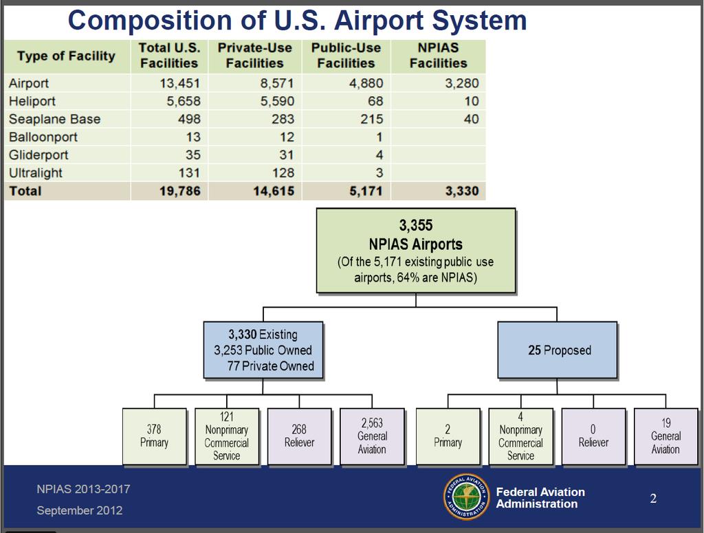
3 I. What is the FAA Airports GIS Program About 544 airports have commercial service in the US About 3,330 receive federal funding and are included in the National Plan of Integrated Airport System (NPIAS) Full Feature Geospatial Data Collection There are about 13,451 Airports and 5,890 Heliports Of those about 8,571 Airports and 5,590 Heliports are private use landing facilities. About 19,786 landing facilities in the FAA database including seaplane bases, gliderports, ballonports and ultralight flightparks Airport point location, runway, and 5010 safety data only 3
4 4


5 Airports GIS I N P U T O U T P U T Survey Data Collection Geodetic Control Photography Control Data Standards Collection Input Aerial Photos Airport Planning Airports GIS Planning Application Engineering Applications Aeronautical Charting data Instrument Procedures data Obstruction data electronic ALP Tool Modification of Standards Tool Airport Design Tool Airspace Evaluation Tool Part 139 Inspections Tool 5
6 Data Distribution Before Airports GIS No aerial photography Airport Layout ADO Paper REQUIRED PDF CAD Modification of ADO Obstruction Surveys to National Geodetic Survey (NGS) No airport HQ 5010 safety data to National Flight Data Center (NFDC) 6
7 Data Distribution After Airports GIS No aerial photography Airport Layout ADO Paper PDF CAD Modification of ADO Obstruction Surveys to National Geodetic Survey (NGS) No airport HQ 5010 safety data to National Flight Data Center (NFDC) Aerial Photography to Cloud Server Digital data ealp derived from feature extraction from photography Modification of Standards digital tracking in Airports GIS Obstruction Surveys in Airports GIS All data airport data in Airports GIS including the 5010 data (starting 2014) 7
8 ealp Candidate Airports FY13 Alaska Region FAI Fairbanks Central Region CID Cedar Rapids DBQ Dubuque Eastern Region PIT Pittsburgh AGC Allegheny County Great Lakes Region RFD Rockford D95 Dupont-Lapeer Northwest Mountain DEN Denver Southern Region ATL Atlanta Southwest Region DFW Dallas-Fort Worth HRL Valley SAT San Antonio ABQ Albuquerque COT Cotulla Western Pacific SFO San Francisco 8
9 Anticipate the Transition to ealp Today 2012 Airports GIS data collection and submittal Sponsor/FAA access to data through Airports GIS Legacy ALP (paper or PDF) Legacy ALP coordination and approval process Near Term Airports GIS data collection and submittal Sponsor/FAA access to data through Airports GIS Electronic Signatures (submittal and approval) ealp (geo-referenced PDF) with legacy ALP review and approval process End State Airports GIS data collection and submittal Sponsor/FAA access to data through Airports GIS Digital ealp submittal Digital ealp review and approval through Airports GIS Geo-referenced PDF (for use outside Airports GIS) Limited e-capability Increasing Efficiency Optimized Efficiency 9
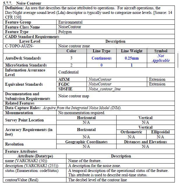
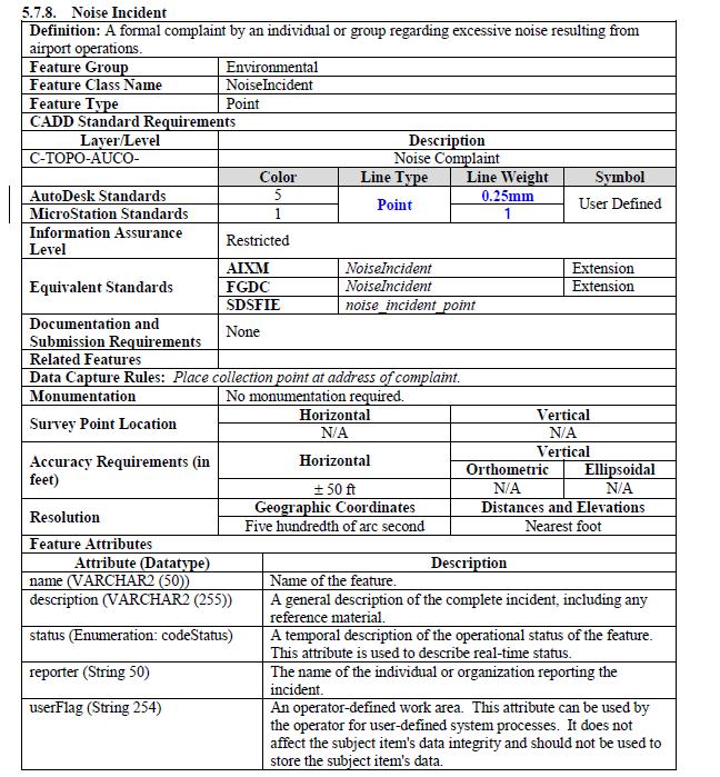
10 II. Environmental Feature Standards Not required on Airport Layout Plan Optional for airport to submit in Airports GIS AC 150/ B Chapter 5 Airport Data Features 11 Feature Groups 5.4 Airfield Group of Feature Classes 5.7 Environmental Group of Feature Classes Noise Contour Noise Incident Noise Monitoring Point 10

11 Slide # of #
12

13 13

14 Atlanta 2008 Noise Contours - OLD 14

15 ATL Airports GIS Data 2008 Contours 15
16 III. Implementation to occur by September Airport View of all civil airports 2. Electronic ALP Module 3. Integration with Cloud Server 4. Modification to Standards Tool 5. Integration with Esri Viewer 16

17 Airports GIS Data Manager Terry L. Rhea Jan 2013 Extensive Esri Experience DHS Booze Allen 17


18 Airport View of 5010 data 18
19 ealp Module Development Discussed in detail next presentation ealp Development Version 1.0 Sept (Tested at OKC) Version 1.1 March 1, 2013 (Upgraded to ArcGIS 10.1 software) Use for 15 Candidate Airports BP requires 3 Airports to submit ealp by 30 Sept BP Requires Version 2.0 Sept (Upgraded to full capability) 19

20 ealp Assembly 20

21 ealp FAA official signature 21

22 Layer list 22

23 Draw and Measure 23
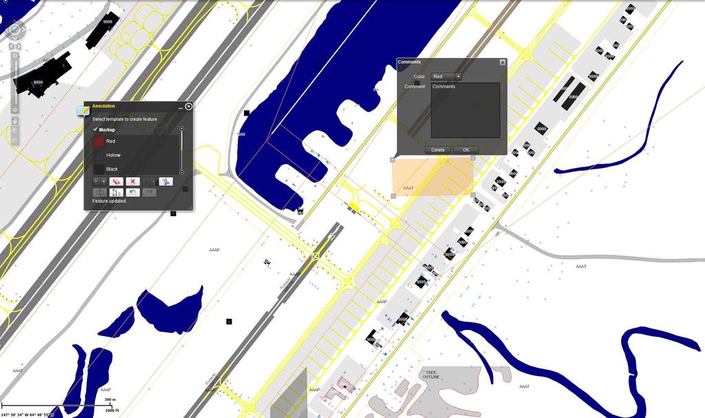
24 Annotation 24
25 Cloud Server Implementation Cloud Server Data by Airport All Collected High Resolution Aerial Photography Currently 450 airports Legacy ALPs in PDF Format Airport Signage and Marking Plans Runway Safety Area Determinations Other optional PDF and Shapefiles SHP and KML files overlaid on aerial photography 25
26 IV. NAV Lean Implementation Aeronautical Data Management (ADM) NAV Lean initiative under ATO Purpose was to streamline data for instrument procedures 1.5 years of weekly meeting and executive buy in Scheduled from March 2013 to September 2015 Includes changing 5010 data to Airports GIS Web Interface AIM Agreement to Cooperate with ARP Airports GIS is Authoritative Source All Surveys enter into Airports GIS AIM will use Airports GIS for Airport Diagrams, Digital NOTAMs, LVO/SMGCS Charting 26
27 V. Document Update Airports GIS Implementation Plan April 15, 2013 Update to AC B Change 1 Clarifications only Draft July 2013 New AC C with schema change 2014/
28 VI. How can you benefit Airport can assign access to consultants High resolution aerial photography Horizontal Accuracy Verified Airport Layout geospatial data Current and future runway locations Upload.shp and PDF files for viewing 28

29 Questions? 29
Geospatial Data Collection for the FAA Airports GIS Program
 Geospatial Data Collection for the FAA Airports GIS Program A Change in Direction Dr. Michael T. McNerney, P.E. FAA Office of Airports Office of Airport Safety and Standards Assistant Manager, Airport
AIRPORTS GIS UPDATE. Federal Aviation Administration. https://airports-gis.faa.gov/
 AIRPORTS GIS UPDATE Presented to ACC Airports Technical Workshop Presented by John R. Dermody, Manager, Airport Engineering Division Date July 29, 2014 1 Airports GIS Update 1. AGIS Overview 2. NAV Lean
agis a brief overview
 agis a brief overview Steve Welebny Photogrammetrist Keystone Aerial Surveys Villanova University 1 Villanova University 2 Nav Aid Cost VOR Install = $250,000 20 year life cycle cost = $1,100,000 ILS Install
Spatio-temporal Data Analysis and Visualization in Enterprise Level Automated Application
 Spatio-temporal Data Analysis and Visualization in Enterprise Level Automated Application Sept 29 - Oct 1, 2015 Kualal Lumpur Shyam Parhi Washington DC What is driving Airports GIS? Reduce costs to Airports,
Update on FAA Standard Operating Procedures (SOP)
") Update on FAA Standard Operating Procedures (SOP) SOP 2.0 - Airport Layout Plan (ALP) SOP 3.0 - Exhibit A Airport Property Map Presented to: Association of California Airports (ACA); ACA Annual Conference,
Update on FAA Standard Operating Procedures (SOP) SOP 2.0 - Airport Layout Plan (ALP) SOP 3.0 - Exhibit A Airport Property Map Presented to: Association of California Airports (ACA); ACA Annual Conference,
GIS and the Electronic ALP Upcoming Changes to Requirements
 GIS and the Electronic ALP Upcoming Changes to Requirements Thomas Wade Regional Planner FAA Southwest Region thomas.wade@faa.gov Gil Neumann Sr Airport Planner FAA National Planning Division gil.neumann@faa.gov
FAA A-GIS and e-alp at Valley International Airport
 FAA A-GIS and e-alp at Valley International Airport Annual ACI Conference Austin, TX October 2009 Kevin Carlson Associate Vice President, Aviation Presentation Overview Introduction to the Program Valley
FAA Update. Dakota-Minnesota (DMA) Airports District Office. Federal Aviation Administration. Presented to: By: Date: South Dakota Airports Conference
 Airports District Office. Federal Aviation Administration. Presented to: By: Date: South Dakota Airports Conference") FAA Update Dakota-Minnesota (DMA) Airports District Office Presented to: By: Date: South Dakota Airports Conference Chris Hugunin & Dave Anderson March 18, 2015 FY 2014 DMA ADO Total AIP Funding $107.2
FAA Update Dakota-Minnesota (DMA) Airports District Office Presented to: By: Date: South Dakota Airports Conference Chris Hugunin & Dave Anderson March 18, 2015 FY 2014 DMA ADO Total AIP Funding $107.2
Federal GIS Conference February 10 11, 2014 Washington DC. ArcGIS for Aviation. David Wickliffe
 Federal GIS Conference 2014 February 10 11, 2014 Washington DC ArcGIS for Aviation David Wickliffe What is ArcGIS for Aviation? Part of a complete system for managing data, products, workflows, and quality
OBSTACLE IDENTIFICATION SURFACE CALCULATION TOOL (OIS CT) FOR AIRPORT AIRSPACE OBSTRUCTION ANALYSES AT CIVIL AIRPORTS IN THE UNITED STATES
 FOR AIRPORT AIRSPACE OBSTRUCTION ANALYSES AT CIVIL AIRPORTS IN THE UNITED STATES") OBSTACLEIDENTIFICATIONSURFACECALCULATIONTOOL(OISCT) FORAIRPORTAIRSPACEOBSTRUCTIONANALYSESATCIVILAIRPORTS INTHEUNITEDSTATES ApostolPanayotov,PhD,Mr.MarkGibbs,M.S.A,A.A.E,Mr.BradKetel IntroductiontotheObstacleIdentificationSurfaceAnalyses
OBSTACLEIDENTIFICATIONSURFACECALCULATIONTOOL(OISCT) FORAIRPORTAIRSPACEOBSTRUCTIONANALYSESATCIVILAIRPORTS INTHEUNITEDSTATES ApostolPanayotov,PhD,Mr.MarkGibbs,M.S.A,A.A.E,Mr.BradKetel IntroductiontotheObstacleIdentificationSurfaceAnalyses
AERONAUTICAL INFORMATION DIGITAL DATBASES INTERGATION AND QUALITY MANAGED MIGRATION
 AIM SG/5 (Egypt, Cairo, 22 24 January 2019) AERONAUTICAL INFORMATION DIGITAL DATBASES INTERGATION AND QUALITY MANAGED MIGRATION Presentation contents : 1. NG Aviation company overview 2. New documentation
Airport Issues in Considering Spaceport Development
 Airport Issues in Considering Spaceport Development Prepared for: Transportation Research Board (TRB) Annual Meeting Session 782 Presented by: Elliott Black Director Office of Airport Planning and Programming
AERONAUTICAL SURVEYS & INSTRUMENT FLIGHT PROCEDURES
 AERONAUTICAL SURVEYS & INSTRUMENT FLIGHT PROCEDURES Current as of November 2012 ALASKA AVIATION SYSTEM PLAN UPDATE Prepared for: State of Alaska Department of Transportation & Public Facilities Division
AGIS/eALP Project Experience
 Agenda AECOM Experience Introduction to AGIS/eALP Executing an AGIS/eALP Sample Data What you can do with the Data? Data Maintenance Questions and Answers AGIS/eALP Project Experience AGIS/eALP Project
Airports and UAS: Integrating UAS into Airport Infrastructure and Planning
 ACRP Problem Statement 17-03-09 Recommended Allocation: $500,000 Airports and UAS: Integrating UAS into Airport Infrastructure and Planning ACRP Staff Comments This is one of four UAS-themed problem statements
Initiated By: AFS-400
 U.S. Department of Transportation Federal Aviation Administration Advisory Circular Subject: Development and Submission of Special Date: 04/14/2015 AC No: 90-112A Instrument Procedures to the FAA Initiated
Planning and Designing Airport Infrastructure to Support GPS and PBN Approach Development
 ACRP Problem Statement 16-07-04 Recommended Allocation: -- Planning and Designing Airport Infrastructure to Support GPS and PBN Approach Development ACRP Staff Comments -- TRB Aviation Committee Comments
From AIS To AIM. Agenda. Agenda. Jack Hsu Mark Varellas
 Agenda Agenda From AIS To AIM 1. Introduction to MDA 2. What is AIS to AIM? 3. FAA Approach to AIM 4. AIM Transition Planning 5. ext Steps 1. Introduction to MDA 2. What is AIS to AIM? 3. FAA Approach
Using LiDAR for Precise Vegetation Management
 Using LiDAR for Precise Vegetation Management Quantum Spatial is a proven partner to airport planners, engineers, facility managers, and contractors whose objective is to build, expand, and make improvements
GIS Specialist at CDM Smith since 2007
 Andrew Clem, GISP SCAUG 2013 Addison, TX One Glen Lakes 8140 Walnut Hill Lane Suite 1000 Dallas, Texas 75231 Andrew Clem, GISP GIS Specialist at CDM Smith since 2007 Projects: Airports GIS (AGIS), environmental
FAA Airports-GIS Program
 FAA Airports-GIS Program FAA Office of the Associate Administrator of Airports (ARP) ARP Airport Safety and Standards (AAS) ARP Airport Planning and Programming (APP) Presented to FGDC Metadata Working
Office of Airport Safety and Standards
 Office of Airport Safety and Standards Airport Lighting Program To: By: Illuminating Engineering Society Aviation Lighting Committee Government Contacts Subcommittee Michael O Donnell, Director Office
Airport Obstruction Standards
 Airport Obstruction Standards Dr. Antonio Trani Department of Civil and Environmental Engineering Virginia Tech Outline of this Presentation Obstructions to navigation around airports Discussion of Federal
Sharing UAE experience in. AIM implementation
 Sharing UAE experience in AIM implementation NCLB AIM WORKSHOP Cairo, Egypt, 11 13 September 2017 MID Region NCLB Strategy No Country Left Behind campaign help ensure all States of effective implementation
Airport AIM as a Service Presented at World ATM Congress 2016
 Airport AIM as a Service Presented at World ATM Congress 2016 Ulrich Kaage Sales Manager AIM Outline Airport data is a considerable part of the AIM data chain The move from paper centric to data driven
Appendix C AIRPORT LAYOUT PLANS
 Appendix C AIRPORT LAYOUT PLANS Appendix C AIRPORT LAYOUT PLANS Airport Master Plan Santa Barbara Airport As part of this Airport Master Plan, the Federal Aviation Administration (FAA) requires the development
Chapter 1 Introduction and Project Overview
 Chapter 1 Introduction and Project Overview Kittitas County in cooperation with the Federal Aviation Administration (FAA) is updating the Airport Master Plan for Bowers Field Airport (FAA airport identifier
Flight Evaluation Schedule For GPS IFR Approval Primary Means Enroute, Terminal and Non-Precision Approach
 Flight Evaluation Schedule For GPS IFR Approval Primary Means Enroute, Terminal and Non-Precision Approach Aircraft Description: Model ZK- Operator GPS Description: Manufacturer Model Serial Number TSO-C129
Airport 20 to 1 Approach Surface
 Airport 20 to 1 Approach Surface 2014 South Carolina Aviation Association Annual Conference Jon Walker Eastern Flight Procedures Team Feb 13, 2014 20 to 1 Surface Area Criteria 14 CFR Part 77; AC 150/5300-13A;
DRAFT MASTER PLAN UPDATE
 DRAFT MASTER PLAN UPDATE CHAPTER VI: AIRPORT LAYOUT PLAN NARRATIVE DRAFT REPORT APRIL 2017 PREPARED BY: Table of Contents WESTCHESTER COUNTY AIRPORT 6 AIRPORT LAYOUT PLAN NARRATIVE REPORT... 6-1 6.1 AGIS
** DETERMINATION OF NO HAZARD TO AIR NAVIGATION **
 Mail Processing Center Federal Aviation Administration Southwest Regional Office Obstruction Evaluation Group 2601 Meacham Boulevard Fort Worth, TX 76137 Issued Date: 05/16/2011 Aeronautical Study No.
Real-time route planning streamlines onboard operations, reduces fuel burn and delays, and improves on-time performance.
 Real-time route planning streamlines onboard operations, reduces fuel burn and delays, and improves on-time performance. Operational Efficiency of Dynamic Navigation Charting Benefits such as improved
Washington Dulles International Airport (IAD) Aircraft Noise Contour Map Update. 6th Working Group Briefing 1/7/19
 Aircraft Noise Contour Map Update. 6th Working Group Briefing 1/7/19") Washington Dulles International Airport (IAD) Aircraft Noise Contour Map Update 6th Working Group Briefing 1/7/19 Study Purpose Agenda Background Summary of last stakeholder meetings Refresher on DNL,
Washington Dulles International Airport (IAD) Aircraft Noise Contour Map Update 6th Working Group Briefing 1/7/19 Study Purpose Agenda Background Summary of last stakeholder meetings Refresher on DNL,
Special Modification To Standards Process for Airplane Design Group VI. The Boeing Federal Aviation Administration
 Special Modification To Standards Process for Airplane Design Group VI The Boeing 747-8 Presented to: ACI-NA First B-747-8 Airport Compatibility Meeting By: George Legarreta, Office of Airport Safety and
SITE ELEVATION AMSL...Ground Elevation in feet AMSL STRUCTURE HEIGHT...Height Above Ground Level OVERALL HEIGHT AMSL...Total Overall Height AMSL
 ******************************************** * Federal Airways & Airspace * * Summary Report * ******************************************** File: User Assigned File Name Latitude: NAD83 Coordinate Longitude:
FAA Update. Dakota-Minnesota (DMA) Airports District Office. Federal Aviation Administration. Presented to: By: Date: Minnesota Council of Airports
 Airports District Office. Federal Aviation Administration. Presented to: By: Date: Minnesota Council of Airports") FAA Update Dakota-Minnesota (DMA) Airports District Office Presented to: By: Date: Minnesota Council of Airports Chris Hugunin April 15, 2015 FY 2014 DMA ADO Total AIP Funding $107.2 Million / 136 Grants
FAA Update Dakota-Minnesota (DMA) Airports District Office Presented to: By: Date: Minnesota Council of Airports Chris Hugunin April 15, 2015 FY 2014 DMA ADO Total AIP Funding $107.2 Million / 136 Grants
TANZANIA CIVIL AVIATION AUTHORITY AIR NAVIGATION SERVICES INSPECTORATE. Title: CONSTRUCTION OF VISUAL AND INSTRUMENT FLIGHT PROCEDURES
 Page 1 of 8 1. PURPOSE 1.1. This Advisory Circular provides guidance to personnel involved in construction of instrument and visual flight procedures for publication in the Aeronautical Information Publication.
STAFF REPORT. Airport Land Use Consistency Determination Betteravia Plaza. MEETING DATE: January 21, 2016 AGENDA ITEM: 8D
 STAFF REPORT SUBJECT: Airport Land Use Consistency Determination Betteravia Plaza MEETING DATE: AGENDA ITEM: 8D STAFF CONTACT: Andrew Orfila RECOMMENDATION: Adopt findings for the Betteravia Plaza project
Kittitas County Airport Bowers Field Airport Master Plan Planning Advisory Committee Meeting #1 April 6, 2016
 Kittitas County Airport Bowers Field Airport Master Plan Planning Advisory Committee Meeting #1 April 6, 2016 Project Team Kittitas County, WA Airport Owner (Sponsor) and Operator, Land Use Century West
Presented to the: NCTCOG Air Transportation Advisory Committee. Presented to the: NCTCOG Air Transportation Advisory Committee
 ...while at FAA By: Kelvin L. Solco, P.E., MBA, President, The Solco Group Presented to the: NCTCOG Air Transportation Advisory Committee Presented to the: NCTCOG Air Transportation Advisory Committee
WIDE AREA AUGMENTATION SYSTEM NOTICES TO AIRMEN (NOTAM) OPERATIONAL CONCEPT April 28, 2008
 OPERATIONAL CONCEPT April 28, 2008") Jimmy R. Snow Satellite Navigation Consultant Norman, OK, USA Tel: 405-249-4329 Fax: 405-329-0636 E-Mail: cjsnow@cox.net WIDE AREA AUGMENTATION SYSTEM NOTICES TO AIRMEN (NOTAM) OPERATIONAL CONCEPT April
Jimmy R. Snow Satellite Navigation Consultant Norman, OK, USA Tel: 405-249-4329 Fax: 405-329-0636 E-Mail: cjsnow@cox.net WIDE AREA AUGMENTATION SYSTEM NOTICES TO AIRMEN (NOTAM) OPERATIONAL CONCEPT April
Planning. In preparing for battle I have always found that plans are useless, but planning is indispensable. Dwight D. Eisenhower
 Planning In preparing for battle I have always found that plans are useless, but planning is indispensable. Dwight D. Eisenhower Adventure is just bad planning. Roald Amundsen, Norwegian Explorer Failure
RISING PERFORMANCE. Civil aviation is an outlier. It s BY ERIK DAHLBERG
 RISING PERFORMANCE Compact mobile mapping systems can be installed on small passenger cars. Civil aviation is an outlier. It s among the few industries where tight government regulations are widely accepted
EXHIBIT A SCOPE OF SERVICES For an AIRPORT MASTER PLAN STUDY AND AIRPORT LAYOUT PLAN (ALP) UPDATE For LAWRENCE MUNICIPAL AIRPORT LAWRENCE, KANSAS
 UPDATE For LAWRENCE MUNICIPAL AIRPORT LAWRENCE, KANSAS") EXHIBIT A SCOPE OF SERVICES For an AIRPORT MASTER PLAN STUDY AND AIRPORT LAYOUT PLAN (ALP) UPDATE For LAWRENCE MUNICIPAL AIRPORT LAWRENCE, KANSAS INTRODUCTION The Lawrence Municipal Airport Master Plan
EXHIBIT A SCOPE OF SERVICES For an AIRPORT MASTER PLAN STUDY AND AIRPORT LAYOUT PLAN (ALP) UPDATE For LAWRENCE MUNICIPAL AIRPORT LAWRENCE, KANSAS INTRODUCTION The Lawrence Municipal Airport Master Plan
Enabling Civilian Low-Altitude Airspace and Unmanned Aerial System (UAS) Operations. Unmanned Aerial System Traffic Management (UTM)
 Operations. Unmanned Aerial System Traffic Management (UTM)") Enabling Civilian Low-Altitude Airspace and Unmanned Aerial System (UAS) Operations By Unmanned Aerial System Traffic Management (UTM) Parimal Kopardekar, Ph.D. UTM Principal Investigator and Manager,
Enabling Civilian Low-Altitude Airspace and Unmanned Aerial System (UAS) Operations By Unmanned Aerial System Traffic Management (UTM) Parimal Kopardekar, Ph.D. UTM Principal Investigator and Manager,
Chapter 1 Introduction and Project Overview
 EPHRATA MUNICIPAL AIRPORT Chapter 1 Introduction and Project Overview The Port of Ephrata in cooperation with the Federal Aviation Administration (FAA) is updating the Airport Master Plan for Ephrata Municipal
Saint Petersburg-Clearwater International Airport. Airspace & Instrument Approach Analysis
 Saint Petersburg-Clearwater International Airport Airspace & Instrument Approach Analysis February 23, 2005 Jeppesen Boeing Jeppesen Government / Military Services Group Airspace Services Division AIRSPACE
Enabling Civilian Low-Altitude Airspace and Unmanned Aerial System (UAS) Operations. Unmanned Aerial System Traffic Management (UTM)
 Operations. Unmanned Aerial System Traffic Management (UTM)") Enabling Civilian Low-Altitude Airspace and Unmanned Aerial System (UAS) Operations By Unmanned Aerial System Traffic Management (UTM) Parimal Kopardekar, Ph.D. UTM Principal Investigator and Manager,
Enabling Civilian Low-Altitude Airspace and Unmanned Aerial System (UAS) Operations By Unmanned Aerial System Traffic Management (UTM) Parimal Kopardekar, Ph.D. UTM Principal Investigator and Manager,
Continuous Descent Arrivals (CDA) Workshop #2
 Workshop #2") Continuous Descent Arrivals (CDA) Workshop #2 FAA Operational Evolution Plan (OEP): Version 8 CDA Core & Ring elements Presented to: EIPT Ops Panel & guests By: Sandy Liu, FAA Office of Environment & Energy
Continuous Descent Arrivals (CDA) Workshop #2 FAA Operational Evolution Plan (OEP): Version 8 CDA Core & Ring elements Presented to: EIPT Ops Panel & guests By: Sandy Liu, FAA Office of Environment & Energy
Office of Airports. Overview of the FAA s. Federal Aviation Administration ACI-NA/AAAE Airport Board & Commissioners Conference Indianapolis, IN
 Overview of the FAA s Office of Airports Prepared for: Presented by: 2016 ACI-NA/AAAE Airport Board & Commissioners Conference Indianapolis, IN Eduardo Angeles Associate Administrator for Airports Date:
Session 10 Non-aeronautical Development of Airport Land
 Session 10 Non-aeronautical Development of Airport Land 31 st Annual AAAE Basics of Airport Law Workshop and 2015 Legal Update November 1-3, 2015 Desk Reference Chapters 14, 15, 23, 28 Daniel S. Reimer
Federal Aviation Administration. Airport Land Use Compatibility Advisory Circular ACI-NA / FAA. FAA HQ Washington, DC March 27, 2013
 Airport Land Use Compatibility Advisory Circular ACI-NA / FAA FAA HQ Washington, DC March 27, 2013 The purpose of this meeting is to discuss FAA s update of the Airport Compatible Land Use Advisory Circular.
Western Service Area Unmanned Aircraft Systems (UAS) Update. Federal Aviation Administration. Defense Symposium
 Update. Federal Aviation Administration. Defense Symposium") Western Service Area Unmanned Aircraft Systems (UAS) Update Presented to: Presented by: Northwest Aerospace & Defense Symposium Matt Gammon, Tactical Operations Team, FAA Western Service Center Date: May
Western Service Area Unmanned Aircraft Systems (UAS) Update Presented to: Presented by: Northwest Aerospace & Defense Symposium Matt Gammon, Tactical Operations Team, FAA Western Service Center Date: May
Washington Dulles International Airport (IAD) Aircraft Noise Contour Map Update
 Aircraft Noise Contour Map Update") Washington Dulles International Airport (IAD) Aircraft Noise Contour Map Update Ultimate ASV, Runway Use and Flight Tracks 4th Working Group Briefing 8/13/18 Meeting Purpose Discuss Public Workshop input
Washington Dulles International Airport (IAD) Aircraft Noise Contour Map Update Ultimate ASV, Runway Use and Flight Tracks 4th Working Group Briefing 8/13/18 Meeting Purpose Discuss Public Workshop input
Safety Enhancement RNAV Safe Operating and Design Practices for STARs and RNAV Departures
 Safety Enhancement Action: Implementers: Statement of Work: Safety Enhancement 213.5 RNAV Safe Operating and Design Practices for STARs and RNAV Departures To mitigate errors on Standard Terminal Arrival
AIS/AIM System in South Africa (ATNS)
") AIS/AIM System in South Africa (ATNS) Description: Dynamic Component comprises of I. Flight Planning and Management II. NOTAM Management (Creation, PIB, etc) III. Internet Briefing and Flight Planning
AIS/AIM System in South Africa (ATNS) Description: Dynamic Component comprises of I. Flight Planning and Management II. NOTAM Management (Creation, PIB, etc) III. Internet Briefing and Flight Planning
Airports and UAS: Managing UAS Operations in the Airport Vicinity
 ACRP Problem Statement 17-10-09 Recommended Allocation: $350,000 Airports and UAS: Managing UAS Operations in the Airport Vicinity ACRP Staff Comments This is one of four UAS-themed problem statements
DP-7 The need for QMS controlled processes in AIS/AIM. Presentation to QMS for AIS/MAP Service Implementation Workshop Dakar, Senegal, May 2011
 DP-7 The need for QMS controlled processes in AIS/AIM Presentation to QMS for AIS/MAP Service Implementation Workshop Dakar, Senegal, 17 19 May 2011 Werner Kurz Director International Relations Jeppesen
II.J. 14 CFR and Publications
 References: 14 CFR Parts 1, 61, 91; NTSB Part 830; AC 00-2; FAA-H-8083-25; POH/AFM; AIM Objectives Key Elements Elements Schedule Equipment IP s Actions SP s Actions Completion Standards The student should
STAFF REPORT. Airport Land Use Plan Consistency Review: Santa Barbara Airport Master Plan. MEETING DATE: November 19, 2015 AGENDA ITEM: 7D
 STAFF REPORT SUBJECT: Airport Land Use Plan Consistency Review: Santa Barbara Airport Master Plan MEETING DATE: AGENDA ITEM: 7D STAFF CONTACT: Peter Imhof, Andrew Orfila RECOMMENDATION: Adopt findings
AUGUST 2017 GNSS REVIEW. Survey Economics Chances of success. Mobile Mapping Airport scanning. Stag s Leap Winery Pre-construction plan
 AUGUST 2017 GNSS REVIEW Survey Economics Chances of success Stag s Leap Winery Pre-construction plan Mobile Mapping Airport scanning RISING PERFORMANCE» ERIK DAHLBERG Civil aviation is an outlier. It s
ARP Forecast Review Critical Aircraft Data Sources
 ARP Forecast Review Critical Aircraft Data Sources Kent Duffy FAA Office of Airports National Planning & Environmental Division, APP-400 December 14, 2015 Aviation Forecasts Airport sponsors
AIXM Annual Conference 2008 Day 2 March 19 th (morning) Migration TO and FROM AIXM from other AMDB Formats. Alan Poole/Dejan Damjanovic
 Migration TO and FROM AIXM from other AMDB Formats. Alan Poole/Dejan Damjanovic") AIXM Annual Conference 2008 Day 2 March 19 th (morning) Migration TO and FROM AIXM from other AMDB Formats Alan Poole/Dejan Damjanovic Overview Background and Problem Definitions. IATA AIS Data Pool Vision.
AIXM Annual Conference 2008 Day 2 March 19 th (morning) Migration TO and FROM AIXM from other AMDB Formats Alan Poole/Dejan Damjanovic Overview Background and Problem Definitions. IATA AIS Data Pool Vision.
Master Plan Update Community Advisory Committee Kick-off Meeting
 Nashville International Airport Master Plan Update Community Advisory Committee Kick-off Meeting September 13, 2018 Agenda Welcome and Introductions Master Plan Objectives Master Plan Process BNA Vision
Airport Master Plan. Rapid City Regional Airport. October 2015 FAA Submittal
 Airport Master Plan Rapid City Regional Airport October 2015 FAA Submittal Rapid City Regional Airport Master Plan Update Table of Contents Executive Summary... i Scope & Timeline... i Forecasts... i Preferred
[Docket No. FAA ; Airspace Docket No. 13-ASW-2] Proposed Amendment of Class E Airspace; Fort Polk, LA
![[Docket No. FAA ; Airspace Docket No. 13-ASW-2] Proposed Amendment of Class E Airspace; Fort Polk, LA](/thumbs/95/125852980.jpg "[Docket No. FAA ; Airspace Docket No. 13-ASW-2] Proposed Amendment of Class E Airspace; Fort Polk, LA") This document is scheduled to be published in the Federal Register on 04/30/2013 and available online at http://federalregister.gov/a/2013-10169, and on FDsys.gov [4901-13] DEPARTMENT OF TRANSPORTATION
This document is scheduled to be published in the Federal Register on 04/30/2013 and available online at http://federalregister.gov/a/2013-10169, and on FDsys.gov [4901-13] DEPARTMENT OF TRANSPORTATION
Menlo Park Fire District Training Division. Unmanned Aerial System Pilot
 Menlo Park Fire District Training Division TASK BOOK FOR THE POSITION OF Unmanned Aerial System Pilot Date Issued TASK BOOK ASSIGNED TO: Individuals name, assignment DATE TASK BOOK INITIATED The material
STUDY OVERVIEW MASTER PLAN GOALS AND OBJECTIVES
 INTRODUCTION An Airport Master Plan provides an evalua on of the airport s avia on demand and an overview of the systema c airport development that will best meet those demands. The Master Plan establishes
Federal Aviation. Administration. Office of Airports. Update from the. Federal Aviation Administration
 Update from the Office of Airports Prepared for: Presented by: Airports Council International (ACI-NA) Small Airports Committee Minneapolis, Minnesota Elliott Black Deputy Director Office of Airport Planning
Runway Length Analysis Prescott Municipal Airport
 APPENDIX 2 Runway Length Analysis Prescott Municipal Airport May 11, 2009 Version 2 (draft) Table of Contents Introduction... 1-1 Section 1 Purpose & Need... 1-2 Section 2 Design Standards...1-3 Section
USE OF 3D GIS IN ANALYSIS OF AIRSPACE OBSTRUCTIONS
 USE OF 3D GIS IN ANALYSIS OF AIRSPACE OBSTRUCTIONS A project by by Samuka D. W. F19/1461/2010 Supervisor; Dr D. N. Siriba 1 Background and Problem Statement The Airports in Kenya are the main link between
Wide Area Augmentation System (WAAS) and Local Area Augmentation System (LAAS) Update
 and Local Area Augmentation System (LAAS) Update") Wide Area Augmentation System (WAAS) and Local Area Augmentation System (LAAS) Update Presented to: By: Date: CGSIC Leo Eldredge, FAA September 24, 2008 Agenda WAAS Architecture WAAS Services Overview
Wide Area Augmentation System (WAAS) and Local Area Augmentation System (LAAS) Update Presented to: By: Date: CGSIC Leo Eldredge, FAA September 24, 2008 Agenda WAAS Architecture WAAS Services Overview
Amendment of Class E Airspace for the following Missouri towns: Chillicothe, MO; Cuba, MO; Farmington, MO; Lamar, MO; Mountain View, MO; Nevada,
 This document is scheduled to be published in the Federal Register on 10/19/2015 and available online at http://federalregister.gov/a/2015-26273, and on FDsys.gov [4910-13] DEPARTMENT OF TRANSPORTATION
Norfolk International Airport
 Norfolk International Airport Master Plan Update Technical Advisory Committee Meeting #1 Community Advisory Committee Meeting #1 January 24, 2018 Agenda Project Background Introductions Overview of Airport
FIT FOR PURPOSE: A Guide to Using NAV CANADA Aeronautical Publications SECTION B PUBLICATION SPECIFIC FIT FOR PURPOSE INFORMATION
 FIT FOR : A Guide to Using NAV CANADA Aeronautical Publications SECTION B PUBLICATION SPECIFIC FIT FOR INFORMATION I TABLE OF CONTENTS SECTION A: GENERAL MATERIAL 2 SECTION B: PUBLICATION SPECIFIC FIT
ICAO/FAA Airport Certification Inspectors Workshop for the Caribbean Region
 ICAO/FAA Airport Certification Inspectors Workshop for the Caribbean Region PREPARING FOR A CERTIFICATION INSPECTION Sint Maarten June 11-15, 2012 1 PREPARING FOR INSPECTION OBJECTIVES Given an airport
ASSEMBLY 35TH SESSION PLENARY. Statements by delegations of Contracting States and of Observers INDONESIAN AIRWORTHINESS SYSTEMS
 P/14 22/07/04 English only ASSEMBLY 35TH SESSION PLENARY Agenda Item 2: Statements by delegations of Contracting States and of Observers INDONESIAN AIRWORTHINESS SYSTEMS (Presented by Indonesia) INFORMATION
Pierre Regional Airport Airport Master Plan. Kickoff Meeting April 7, 2017
 Pierre Regional Airport Airport Master Plan Kickoff Meeting April 7, 2017 Agenda Introductions Airport Master Planning Planning Considerations Master Plan Elements Schedule Public Involvement Basics about
DTW Class B Airspace Redesign Proposal
 DTW Class B Airspace Redesign Proposal Presented for Informal Public Meetings, July 20-22, 2010 Presented to: Informal Public Meetings By: John Hoelscher, Lockheed Martin Date: July 20-22, 2010 The current
Dallas Executive Airport Town Hall Meeting April 3, 2014
 Dallas Executive Airport Town Hall Meeting April 3, 2014 Background 1,040 acre general aviation facility owned and operated by the City of Dallas 150 based aircraft including business jets and helicopters,
AIRPORT COMMITTEE MEETING AGENDA September 06, :00 PM Moorhead Municipal Airport
 AIRPORT COMMITTEE MEETING AGENDA September 06, 2017-4:00 PM Moorhead Municipal Airport 1. Call to Order 2. Agenda Amendments 3. Approval of Minutes A June 14, 2017 4. Citizens to be Heard 5. Airport Capital
CHAPTER 1: INTRODUCTION
 CHAPTER 1: INTRODUCTION Purpose and Scope The information presented in this report represents the study findings for the 2016 Ronan Airport Master Plan prepared for the City of Ronan and Lake County, the
HILLSBOROUGH COUNTY BENCHMARKS IN GOOGLE EARTH
 HILLSBOROUGH COUNTY BENCHMARKS IN GOOGLE EARTH By Thomas G. Davis 1, PhD, PE, PLS; L. Scott Brown 2, PLS; and Rollins Turner 3, PhD INTRODUCTION HCBM (http://www.metzgerwillard.us/hcbm/) is a web-based
SANTA FE MUNICIPAL AIRPORT (SAF) SANTA FE, NM
 SANTA FE, NM") SEPTEMBER 13-15, 2018 SANTA FE MUNICIPAL AIRPORT (SAF) SANTA FE, NM SPECIAL FLIGHT PROCEDURES EFFECTIVE: Thursday Sept 13, 2018 12:00 NOON MDT until 7:00 PM MDT Friday Sept 14, 2018 7:00 AM MDT until 7:00
SEPTEMBER 13-15, 2018 SANTA FE MUNICIPAL AIRPORT (SAF) SANTA FE, NM SPECIAL FLIGHT PROCEDURES EFFECTIVE: Thursday Sept 13, 2018 12:00 NOON MDT until 7:00 PM MDT Friday Sept 14, 2018 7:00 AM MDT until 7:00
Naples Airport Authority Board of Commissioners and Noise Compatibility Committee Special Meeting on Central/South Florida Metroplex
 Naples Airport Authority Board of Commissioners and Noise Compatibility Committee Special Meeting on Central/South Florida Metroplex March 16, 2017 Ted Baldwin and Robert Mentzer Metroplex Overview: From
AIRFIELD SAFETY IN THE UNITED STATES
 International Civil Aviation Organization 24/11/09 North American, Central American and Caribbean Office (NACC) Twenty Second Meeting of Directors of Civil Aviation of the Eastern Caribbean (E/CAR/DCA/22)
User Forum AIM/EAD Evolutions. Thanos PAPAVRAMIDIS, Head of Airspace and AIS Data Management EUROCONTROL Network Management
 User Forum 2011 AIM/EAD Evolutions Thanos PAPAVRAMIDIS, Head of Airspace and AIS Data Management EUROCONTROL Network Management The European Organisation for the Safety of Air Navigation EAD General Concept
Assignment 10: Final Project
 CEE 4674: Airport Planning and Design Spring 2017 Assignment 10: Final Project Due: May 4, 2017 (via email and PDF) Final Exam Time is May 5 Requirements for this assignment are: a) Slide presentation
Proposed Revocation of Class E Airspace; Alliance, NE; and Amendment of Class E
 This document is scheduled to be published in the Federal Register on 05/03/2016 and available online at http://federalregister.gov/a/2016-10176, and on FDsys.gov [4910-13] DEPARTMENT OF TRANSPORTATION
AIM WG: Contributing to ATM Success. Roland Baumann Head Planning & Development AIM skyguide
 AIM WG: Contributing to ATM Success Roland Baumann Head Planning & Development AIM skyguide AIM Contributing to ATM Success change of the value proposition towards ATM Information Management Services the
DRAFT FINAL REPORT AIRPORT MASTER PLAN. Rifle Garfield County Airport Revised May 15, 2014
 DRAFT FINAL REPORT AIRPORT MASTER PLAN Rifle Garfield County Airport Revised May 15, 2014 As required by Paragraph 425.B(4) of FAA Order 5100.38C, Airport Improvement Program (AIP) Handbook: The preparation
American Institute of Aeronautics and Astronautics
 Speech by Jeff Hmara to the American Institute of Aeronautics and Astronautics Tuesday April 25, 2002 FREE FLIGHT 1500 K Street, NW Suite 500 Washington, DC 20005 WHAT IS FREE FLIGHT?...3 CORE CAPABILITIES...3
FAA FORM UAS COA Attachment FAA
 Page 1 of 6 DEPARTMENT OF TRANSPORTATION FEDERAL AVIATION ADMINISTRATION CERTIFICATE OF WAIVER OR AUTHORIZATION ISSUED TO Xcam Aerials, Inc. 10197 SE 144th Place Summerfield, FL 34491 This certificate
The D-AIM Project and Trials. Roger Li, D-AIM Project Manager LFV AIXM/WXXM Conference Washington DC, May 13, 2009
 The D-AIM Project and Trials Roger Li, D-AIM Project Manager LFV AIXM/WXXM Conference Washington DC, May 13, 2009 D-AIM Background Cooperation between LFV (Swedish Airports and Air Navigation Services)
FliteStar USER S GUIDE
 FliteStar USER S GUIDE 2003 Jeppesen Sanderson, Inc. All rights reserved. Printed in the United States of America. No part of this publication may be reproduced, stored in a retrieval system, or transmitted,
Optimized Profile Descents A.K.A. CDA A New Concept RTCA Airspace Working Group
 Optimized Profile Descents A.K.A. CDA A New Concept RTCA Presented to Environmental Working Group December 05, 2007 Outline RTCA Charter and Terms of Reference Objectives Membership and Organization Activities
Navigation Data Chain Certification
 853d Electronic Systems Group Navigation Data Chain Certification Prepared by: 853rd ELSG/NT Electronic Systems Center Hanscom AFB, MA 23 May 2008 Nav Data Chain Certification Overview Background Why certify
Recommended Performance Measures
 Recommended Performance Measures January 2009 1 RECOMMENDED PERFORMANCE MEASURES Performance measures are utilized by the North Central Texas Council of Governments (NCTCOG) to monitor the performance
Aeronautical Data Quality - A New Challenge for Surveyors
 Aeronautical Data Quality - A New Challenge for Surveyors Ralf Wolfgang SCHROTH, Germany Key words: surveying, work flow management, aeronautical data quality, International Civil Aviation Organisation
INTERNATIONAL CIVIL AVIATION ORGANIZATION AFI REGION AIM IMPLEMENTATION TASK FORCE. (Dakar, Senegal, 20 22nd July 2011)
") IP-5 INTERNATIONAL CIVIL AVIATION ORGANIZATION AFI REGION AIM IMPLEMENTATION TASK FORCE (Dakar, Senegal, 20 22nd July 2011) Agenda item: Presented by: Implementation of a African Regional Centralised Aeronautical
IP-5 INTERNATIONAL CIVIL AVIATION ORGANIZATION AFI REGION AIM IMPLEMENTATION TASK FORCE (Dakar, Senegal, 20 22nd July 2011) Agenda item: Presented by: Implementation of a African Regional Centralised Aeronautical