Transportation Improvement District (TID) Exercise New Castle County Unified Development Code
|
|
|
- Loreen Porter
- 5 years ago
- Views:
Transcription

. Additionally, given the direct access to commuter rail, Advanced Labs Inc.")
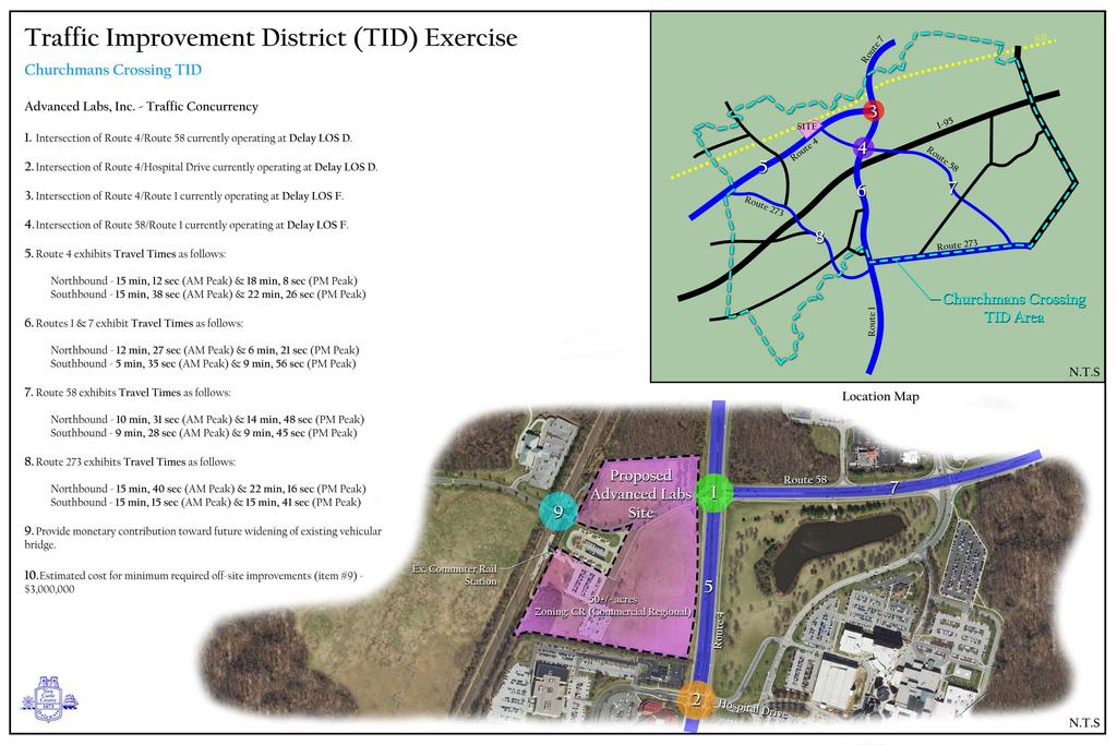
1 Transportation Improvement District (TID) Exercise New Castle County Unified Development Code Churchmans Crossing TID How should New Castle County deploy Transportation Improvement Districts (TIDs)? Site Background: Advanced Labs, Inc. is seeking to make a momentous investment in New Castle County by proposing a 650,000 square foot office/laboratory facility on a 50-acre parcel with 530 full-time jobs that, on average, pay two-anda-half times the per capita household income in the County ($58,000/yr). Additionally, given the direct access to commuter rail, Advanced Labs Inc. would like to include an integrated apartment, hotel and commercial retail component of the development, totaling an additional 490,000 square feet. The facility will specialize in the research and development of a wide variety of cancer-fighting drugs and therapies in coordination with nearby medical centers and a regional hospital. The site is zoned CR (Commercial Regional) and is Figure 1 located on the northern side of the Churchmans Crossing TID. Several arterial road intersections nearest to the site are currently operating between Delay LOS C and F during either the morning or evening peak hour --and will continue to operate as such whether or not the project is built. Conversely, through the Churchmans Crossing TID area, Travel Times for the major arterials are as follows: Route 4 Eastbound 15 min, 12 sec (AM Peak) & 18 min, 8 sec (PM Peak) along the 6.19 mile segment Freeflow (overnight hours) time average is 10 min, 34 sec Westbound 15 min, 38 sec (AM Peak) & 22 min, 26 sec (PM Peak) along the 6.32 mile segment Freeflow (overnight hours) time average is 11 min, 1 sec Routes 1 & 7 Northbound 12 min, 27 sec (AM Peak) & 6 min, 21 sec (PM Peak) along the 6.25 mile segment Freeflow (overnight hours) time average is 5 min, 27 sec
2 Southbound 5 min, 35 sec (AM Peak) & 9 min, 56 sec (PM Peak) along the 5.64 mile segment Freeflow (overnight hours) time average is 4 min, 52 sec Route 58 Eastbound 10 min, 31 sec (AM Peak) & 14 min, 48 sec (PM Peak) along the 3.95 mile segment Freeflow (overnight hours) time average is 7 min, 27 sec Westbound 9 min, 28 sec (AM Peak) & 9 min, 45 sec (PM Peak) along the 3.94 mile segment Freeflow (overnight hours) time average is 6 min, 26 sec Route 273 Eastbound 15 min, 40 sec (AM Peak) & 22 min, 16 sec (PM Peak) along the 6.38 mile segment Freeflow (overnight hours) time average is 10 min, 31 sec Westbound 15 min, 15 sec (AM Peak) & 15 min, 41 sec (PM Peak) along the 6.38 mile segment Freeflow (overnight hours) time average is 9 min, 10 sec If the project is built, Travel Times will adjust as follows: Route 4 Eastbound increase by 7 sec (AM Peak) & 9 sec (PM Peak) Westbound increase by 6 sec (AM Peak) and 6 sec (PM Peak) Routes 1 & 7 Northbound increase by 3 sec (AM Peak) & 4 sec (PM Peak) Southbound increase by 4 sec (AM Peak) and 5 sec (PM Peak) Route 58 Eastbound increase by 6 sec (AM Peak) & 35 sec (PM Peak) Westbound increase by 24 sec (AM Peak) and 1 sec (PM Peak) Route 273 Eastbound increase by 2 sec (AM Peak) 1 sec (PM Peak) Westbound increase by 1 sec (AM Peak) & 2 sec (PM Peak) Additionally, the development would, at a minimum, have to provide a monetary contribution toward widening the existing vehicular bridge that spans the adjacent rail line. The minimum required roadway improvements are estimated to cost the applicant $3,000,000.
3 Transportation Improvement District (TID) Exercise New Castle County Unified Development Code Churchmans Crossing TID Questions The County has commissioned your committee to assist in developing a TID for this area, and has the following questions: 1. When thinking about transportation issues in the area, how would you prioritize the following guiding values (rank from 1 to 7)? a. Local circulation planning b. Network transportation planning c. Vehicle congestion relief d. Matching density/floor area to road capacity e. Walkability/bikeability f. Compact/efficient development patterns g. Transit access 2. When determining the need for a TID, how would you prioritize the following considerations? (Rank each High, Medium or Low) a. Providing transportation improvements b. Job creation c. Community character d. Trip reduction e. Project size f. Need for reinvestment g. Countywide development patterns 3. In establishing a TID, are the following appropriate criteria to be considered? a. Natural/manmade barriers b. Highways without local access c. Railroads d. Trip distribution e. Jobs f. Transit Corridors g. Surrounding/Adjacent Future Land Use h. Zoning categories i. Infrastructure availability 4. Which of the following elements should a TID affect?
4 a. Current LOS standards (i.e. Delay LOS) b. New LOS measurements examples: i. Don t measure certain turning movements? ii. Use volume to capacity (v/c) iii. Don t regulate peak hour? iv. Expand/contract peak hour v. Measure travel time change on roadway segments c. Payments in lieu of development delay or density reduction etc. d. Time period for payments e. Trip generation mitigations f. Transportation infrastructure measured (road lanes, intersections, transit, sidewalks, etc.) g. Mode substitution (for example, transit capacity for road capacity)
5
6

 2015 F F SR 141 SB & Airport Rd.")

 2016 C F SR 7 (Limestone Rd) & SR 4 (Main St.")
7 Sample Site #3: Churchman s TID Current Intersection and Travel Time LOS Intersection Delay Level of Service (LOS) The two maps to the right show the most recent recorded Intersection LOS analysis results for signalized intersections within the TID boundary. Intersections with LOS D or Higher AM Intersection LOS PM Intersection LOS Intersection Year Count AM LOS PM LOS Chapman Rd. & Wakefield Dr D D Churchmans Rd. & Christiana Hosp D C Churchmans Rd. & Del Tech Ent C F Harmony Rd. & Ruthar Dr D D Old Baltimore Pk. & Salem Church Rd C D Old Baltimore Pk. & Trevett Blvd D B Red Mill Rd. & Ruthar Dr C D Salem Church Rd. & Chapman Rd D D SR 141 & SR 37 (Commons Blvd.) 2015 F F SR 141 SB & Airport Rd C D SR 273 & Chapman Rd (Eagle Run) 2013 F D SR 273 & Harmony Rd E F SR 273 & Appleby Rd F D SR 273 & Brownleaf Dr F F SR 273 & Browns Lane 2012 F D SR 273 & Edinburgh Dr D D SR 273 & Old Balt. Pike 2013 F E SR 273 & SR 1 NB Ramp 2012 C D SR 4 & Churchman's Rd D D SR 4 & Harmony Rd F F SR 4 & Hygeia Dr C D SR 4 & Salem Church Rd D D SR 4 & Samoset Dr C D SR 4 & SR 7/JP Morgan Ent D D SR 58 & Airport Rd E D SR 7 & AAA Blvd/Frontage Rds C D SR 7 & Road A 2015 B F SR 7 & SR 58 (Churchmans Rd.) 2016 C F SR 7 (Limestone Rd) & SR 4 (Main St.) 2011 D E US 13 & SR D D Intersection Delay LOS LOS F: Over 80 Seconds LOS E: Seconds LOS D: Seconds LOS C+: Less than 35 Seconds Intersection Delay LOS LOS F: Over 80 Seconds LOS E: Seconds LOS D: Seconds LOS C+: Less than 35 Seconds Peak Period Travel Time Reliability Fall 2017 AM Peak Period Travel Time Reliability (7-9am) SR 4 Begin/ end travel time PM Peak Period Travel Time Reliability (4-6pm) SR 4 Begin/ end travel time Reliability is a measure that calculates the difference in travel time during a giv en time of day v ersus a measured off-peak travel time to represent the roadway at uncongested conditions. The result is what is described as the Trav el Time Reliability Index. According to the FHWA, unreliable travel times begin when measured travel speed reaches 1.5 times that of uncongested conditions*. SR 273 Begin/ end travel time SR 273 Begin/ end travel time While there are no recognized standards that specify the thresholds, The chart below illustrates the reliability thresholds used in this analysis. SR 4 Begin/ end travel time SR 3 Begin/ end travel time Travel Time Relibility Thresholds "LOS F" More than 2.5 times uncongested travel time "LOS E" 2.0 to 2.5 times uncongested travel time "LOS D" 1.5 to 2.0 times uncongested travel time SR 273 Begin/ end travel time SR 273 Begin/ end travel time "LOS C+" Less than 1.5 times uncongested travel time The two maps to the right show the AM and PM peak period travel time reliability by road segment. Source: NPMRDS, INRIX. *Note: Fall 2017 period is a aggregation of data from ev ery Monday-Thursday from 9/11/17 to 11/16/17. Freeflow is the off-peak trav el times calculated from av erage from 11pm-5am from the entire 2017 calendar year. SR 4 Total Corridor Travel Time Comparisons Eastbound SR 4- Salem Church Rd. to Newport (James St.) 6.19 miles Freeflow Travel time 10 min. 34 sec. AM Peak: 7:30-8:30am 15 min, 12 sec. LOS C+ Westbound SR 4- Newport (James St.) to Salem Church Rd miles Freeflow Travel time 11 min. 1 sec. AM Peak: 7:30-8:30am 15 min, 38 sec. LOS C+ SR 273 Total Corridor Travel Time Comparisons Eastbound SR 273- SR 4 to US 13 Freeflow Travel time 6.38 miles 10 min. 31 sec. AM Peak: 6:45-7:45am 15 min, 40 sec. LOS D Westbound SR 273- US 13 to SR 4 Freeflow Travel time 6.38 miles 9 min. 10 sec. AM Peak: 7:30-7:45am 17 min, 15 sec. LOS D SR 4 Total Corridor Travel Time Comparisons Eastbound SR 4- Salem Church Rd. to Newport (James St.) 6.19 miles Freeflow Travel time 10 min. 34 sec. PM Peak: 4:45-5:45pm 18 min. 8 sec. LOS D Westbound SR 4- Newport (James St.) to Salem Church Rd miles Freeflow Travel time 11 min. 1 sec. PM Peak: 5-6pm 22 min. 26 sec. LOS E SR 273 Total Corridor Travel Time Comparisons Eastbound SR 273- SR 4 to US 13 Freeflow Travel time 6.38 miles 10 min. 31 sec. PM Peak: 4:45-5:45pm 22 min. 16 sec. LOS E Westbound SR 273- US 13 to SR 4 Freeflow Travel time 6.38 miles 9 min. 10 sec. PM Peak: 4:30-5:30pm 15 min. 41 sec. LOS D
 includes a variety of zoning districts that determine the type and")


8 Sample Site #3: Churchman s TID Current Intersection and Travel Time LOS 2012 Future Land Use Current Zoning. The New Castle County Unified Development Code (UDC) includes a variety of zoning districts that determine the type and amount of development that can be built within each zoning district. Source: New Castle County Land Use Source: New Castle County Land Use Employment and Worker Flows The Longitudinal Employer-Household Dynamics (LEHD) program is part of the Center for Economic Studies at the U.S. Census Bureau. Using this data, we can compile employment origin/destination profiles of specific areas within the county. The illustration to the right details the movement of workers to and from the TID boundary. It captures: - Total number of jobs within the TID - The number of workers who come from outside the TID to fill those jobs - The number of those who live within the TID who work and if they work outside of the TID Employment and Worker Flows within Churchman s TID Live and Work within TID 3,105 Live in TID but Employed Outside 11,263 Employment & Worker Flows EMPLOYMENT within Churchmans TI D Count Share Employed in the TID 54, % Employed in the TID but Living Outside 51, % Employed and Living in the TID 3, % Source: US Census Longitudinal Employer-Household Dynamics Liv ing in the TI D 14, % Living in the TID but Employed Outside 11, % Living and Employed in the TID 3, %
5.1 Traffic and Transportation
 5.1 When it opens in 2009, the Bellevue Nickel Improvement Project will increase the number of vehicles able to travel through the study area, improve travel speeds, and improve safety by reducing the
TRANSPORTATION ELEMENT
 Transportation TRANSPORTATION ELEMENT Data, Inventory, and Analysis Prepared by Contents 1.0 INTRODUCTION... 1 2.0 EXISTING CONDITIONS... 1 2.1 Roadways... 1 2.1.1 Jurisdiction... 1 2.1.2 Functional Classification...
CENTRAL OREGON REGIONAL TRANSIT MASTER PLAN
 Central Oregon Regional Transit Master Plan Volume II: Surveys and Market Research CENTRAL OREGON REGIONAL TRANSIT MASTER PLAN Volume IV: Service Plan Appendices A-B July 213 Nelson\Nygaard Consulting
%g 109 %g 9. %g 99. %g 9. %g 4. %g 4 %g ,95 (/ 1. Route 109 Corridor Study. %g 35. Corridor Study Area Study Area. Sanford.
 %g 4A %g 109 %g 4 Sanford %g 4 %g 109 %g 99 North Berwick Wells 3 0 3 Miles Route 109 Corridor Study %g 9 %g 109 %g 9A %g9a %g 9 Kennebunk.-,95 W N S E EXIT 2 MEETING HOUSE RD BRAGDO N RD 20 2 %g1 1 (/
Proposed Bicycle Lanes on Yonge Street from Queens Quay to Front Street
 STAFF REPORT ACTION REQUIRED Proposed Bicycle Lanes on Yonge Street from Queens Quay to Front Street Date: March 12, 2007 To: From: Toronto and East York Community Council Director, Transportation Infrastructure
Lake Erie Commerce Center Traffic Analysis
 LOCATION: East of NYS Route 5 at Bayview Road Town of Hamburg Erie County, New York PREPARED BY: Wendel Companies 140 John James Audubon Parkway Suite 200 Amherst, New York 14228 January 2012 i ii Table
A. CONCLUSIONS OF THE FGEIS
 Chapter 11: Traffic and Parking A. CONCLUSIONS OF THE FGEIS The FGEIS found that the Approved Plan will generate a substantial volume of vehicular and pedestrian activity, including an estimated 1,300
MEMORANDUM. Open Section Background. I-66 Open Section Study Area. VDOT Northern Virginia District. I-66 Project Team. Date: November 5, 2015
 MEMORANDUM To: VDOT Northern Virginia District From: I-66 Project Team Date: November 5, 2015 Subject: Open Section Background The purpose of this technical memorandum is to provide narrative and technical
B. Congestion Trends. Congestion Trends
 B. Congestion Trends Congestion Trends There are two types of congestion that impact mobility: recurring and non-recurring congestion. Recurring congestion is related to segments of roadway that are over
Planning. Proposed Development at the Southeast Corner of Lakeshore Road West and Brookfield Road Intersection FINAL.
 Project No. 121-22908 N o v e m b e r 2 0 1 2 Traffic Impact Study Transportation Planning th GENIVAR Inc., 600 Cochrane Drive, 5 Floor, Markham, Ontario L3R 5K3 Telephone: 905.475.7270 Fax: 905.475.5994
APPENDIX H MILESTONE 2 TRAFFIC OPERATIONS ANALYSIS OF THE AT-GRADE CROSSINGS
 Draft Environmental Impact Statement/Environment Impact Report Appendix H Milestone 2 Traffic Operations Analysis of the At-Grade Crossings APPENDIX H MILESTONE 2 TRAFFIC OPERATIONS ANALYSIS OF THE AT-GRADE
Mercer SCOOT Adaptive Signal Control. Karl Typolt, Transpo Group PSRC RTOC July 6th, 2017
 Mercer SCOOT Adaptive Signal Control Karl Typolt, Transpo Group PSRC RTOC July 6th, 2017 Our mission, vision, and core values Mission: deliver a high-quality transportation system for Seattle Vision: connected
Metro ExpressLanes April 5, 2011 Community Meeting re: Adams Blvd Improvements
 Metro ExpressLanes April 5, 2011 Community Meeting re: Adams Blvd Improvements Jan Perry Councilwoman, District 9 Welcome Remarks Arthur T. Leahy Chief Executive Officer, Metro Metro ExpressLanes Overview
MEMORANDUM. Lynn Hayes LSA Associates, Inc.
 MEMORANDUM To: Lynn Hayes LSA Associates, Inc. Date: May 5, 217 From: Zawwar Saiyed, P.E., Senior Transportation Engineer Justin Tucker, Transportation Engineer I Linscott, Law & Greenspan, Engineers LLG
Interstate 90 and Mercer Island Mobility Study APRIL Commissioned by. Prepared by
 Interstate 90 and Mercer Island Mobility Study APRIL 2017 Commissioned by Prepared by Interstate 90 and Mercer Island Mobility Study Commissioned by: Sound Transit Prepared by: April 2017 Contents Section
TABLE OF CONTENTS. Coral Springs Charter High School and Middle School Job No Page 2
 Job No. 15-019 Page 2 TABLE OF CONTENTS 1.0 INTRODUCTION... 4 2.0 EXISTING CONDITIONS... 5 3.0 TRAFFIC GENERATION... 7 4.0 TRIP DISTRIBUTION... 8 5.0 FUTURE CONDITIONS... 8 6.0 SITE ACCESS...13 7.0 CONCLUSION...13
Major Projects Overview
 Major Projects Overview Miami-Dade Expressway Authority February 2018 About MDX MDX operates 5 roads in Miami Dade County SR 924, SR 112, SR 836, SR 874 and SR 878 MDX Primary Source of Revenue: User Fees-Tolls
Memorandum. Roger Millar, Secretary of Transportation. Date: April 5, Interstate 90 Operations and Mercer Island Mobility
 Memorandum To: From: The Honorable Dow Constantine, King County Executive; The Honorable Ed Murray, City of Seattle Mayor; The Honorable Bruce Bassett, City of Mercer Island Mayor; The Honorable John Stokes,
CONGESTION REPORT 1 st Quarter 2018
 CONGESTION REPORT 1 st Quarter 2018 A quarterly update of the National Capital Region s traffic congestion, travel time reliability, top-10 bottlenecks and featured spotlight Feburary 11, 2019 ABOUT TPB
Appendix B Connecting Track Options Evaluation Criteria
 Appendix B Connecting Track Options Evaluation Criteria 608979-853_ra_July5-0_App Title Pages.Docx TTC ASHBRIDGES BAY MAINTENANCE AND STORAGE FACILITY CONNECTING TRACK ROUTE ALTERNATIVE - EVAULATION MATRIX.0
7272 WISCONSIN AVENUE LOCAL AREA TRANSPORTATION REVIEW
 7272 LOCAL AREA TRANSPORTATION REVIEW AND TRANSPORTATION POLICY AREA REVIEW MONTGOMERY COUNTY, MARYLAND Submitted on behalf of Carr Properties Prepared by: Wells + Associates, Inc. Submission: July 1,
NAPA VALLEY VISITOR INDUSTRY 2014 Economic Impact Report
 NAPA VALLEY VISITOR INDUSTRY 2014 Economic Impact Report Research prepared for Visit Napa Valley by Destination Analysts, Inc. Table of Contents SECTION 1 Introduction 2 SECTION 2 Executive Summary 5 SECTION
Traffic Analysis Final Report
 SR-71 Widening Project Project Approval/Environmental Documentation Traffic Analysis Final Report Prepared for Caltrans District 7 August 2012 6 Hutton Centre Drive, Suite 700 Santa Ana, California 92707
LUDWIG RD. SUBDIVISION PROJECT TRAFFIC IMPACT ANALYSIS
 LUDWIG RD. SUBDIVISION PROJECT TRAFFIC IMPACT ANALYSIS Prepared for Skip Coddington GSC Development, Inc PO Box 1623 Woodinville WA 9872 Prepared by 1141 NE 124 th St., #59 Kirkland, WA 9834 425.522.4118
FHWA P/N Guidelines. Corridor Relationship. Highway 22 Segment 1 - US 169 to CSAH 2 Relevance / Documentation of Need
 Highway 22 Segment 1 - US 169 to CSAH 2 Vehicle Mobility Congestion Intersection Congestion Existing Conditions - Based on Highway Capacity Manual methodology, corridor level of service is currently LOS
Project Advisory Group. May 23, 2013
 Project Advisory Group May 23, 2013 1 Introductions and Review Review the three recommended Alternatives for detailed evaluation Next Steps Schedule and upcoming meetings Other discussion 2 Delay the Open
Project Application. General Information ODOT PID. ODOT District. Primary County (3 char abrv)
") Current Status (Tier 1, Tier 2 or New) Proposed Status (Tier 1 or Tier 2) Project Application General Information ODOT PID ODOT District County (3 char abrv) Facility Name (i.e. route, rail, terminal,
Current Status (Tier 1, Tier 2 or New) Proposed Status (Tier 1 or Tier 2) Project Application General Information ODOT PID ODOT District County (3 char abrv) Facility Name (i.e. route, rail, terminal,
NAPA VALLEY VISITOR INDUSTRY 2012 Economic Impact Report
 Join Visit Napa Valley NAPA VALLEY VISITOR INDUSTRY 2012 Economic Impact Report Research prepared for Visit Napa Valley by Destination Analysts, Inc. Table of Contents SECTION 1 Introduction 2 SECTION
US 19 Sunset Point Rd to Countryside Blvd.
 Frontage Lanes Alternative Six-Lane Roadway Two-Lane, One-Way Frontage Lanes Close All Median Openings w/ Concrete Median Barrier Construct Within Existing Right-of-Way Status Update Construction started
Mount Pleasant (42, 43) and Connecticut Avenue (L1, L2) Lines Service Evaluation Study Open House Welcome! wmata.com/bus
 and Connecticut Avenue (L1, L2) Lines Service Evaluation Study Open House Welcome! wmata.com/bus") Mount Pleasant (42, 43) and Connecticut Avenue (L1, L2) Lines Service Evaluation Study Open House Welcome! Study Overview and Timeline Phase 1: Collect and Analyze Data Project Kickoff, September 2017
Mount Pleasant (42, 43) and Connecticut Avenue (L1, L2) Lines Service Evaluation Study Open House Welcome! Study Overview and Timeline Phase 1: Collect and Analyze Data Project Kickoff, September 2017
Arlington County Board Work Session Eastbound Widening January 17, Amanda Baxter, VDOT Special Projects Development Manager
 Arlington County Board Work Session Eastbound Widening January 17, 2017 Amanda Baxter, VDOT Special Projects Development Manager Program Area Map 2 Program Scope Tolling during weekdays, peak hours, peak
Pedestrian Safety Review Spadina Avenue
 STAFF REPORT ACTION REQUIRED Pedestrian Safety Review Spadina Avenue Date: October 13, 2015 To: Toronto and East York Community Council From: Director, Transportation Services, Toronto and East York District
HOV LANE PERFORMANCE MONITORING: 2000 REPORT EXECUTIVE SUMMARY
 Final Report Research Project Agreement No. T1803, Task 4 HOV Monitoring V HOV LANE PERFORMANCE MONITORING: 2000 REPORT EXECUTIVE SUMMARY by Jennifer Nee TRAC Research Engineer John Ishimaru TRAC Senior
SANTA CLARA COUNTY I-280 CORRIDOR STUDY
 SANTA CLARA COUNTY I-280 CORRIDOR STUDY Appendix B 2 Technical Memorandum Existing Transportation Condition Memo SANTA CLARA VALLEY TRANSPORTATION AUTHORITY (VTA) 1-1 Introduction The I-280 Corridor Study
NAPA VALLEY VISITOR INDUSTRY 2016 Economic Impact Report
 NAPA VALLEY VISITOR INDUSTRY 2016 Economic Impact Report Research prepared for Visit Napa Valley by Destination Analysts, Inc. Table of Contents S E C T I O N 1 Introduction 2 S E C T I O N 2 Executive
SR 934 Project Development And Environment (PD&E) Study
 Study") SR 934 Project Development And Environment (PD&E) Study Project Advisory Group Meeting March 1, 2018 State Road 934/NE/NW 79th Street from west of I-95 (NW 13th CT) to N. Bayshore Drive PD&E STUDY SR 934/NE/NW
SR 934 Project Development And Environment (PD&E) Study Project Advisory Group Meeting March 1, 2018 State Road 934/NE/NW 79th Street from west of I-95 (NW 13th CT) to N. Bayshore Drive PD&E STUDY SR 934/NE/NW
Business Growth (as of mid 2002)
") Page 1 of 6 Planning FHWA > HEP > Planning > Econ Dev < Previous Contents Next > Business Growth (as of mid 2002) Data from two business directories was used to analyze the change in the number of businesses
Page 1 of 6 Planning FHWA > HEP > Planning > Econ Dev < Previous Contents Next > Business Growth (as of mid 2002) Data from two business directories was used to analyze the change in the number of businesses
10.0 Recommendations Methodology Assumptions
 10.0 Recommendations To accommodate the projected growth of the I-526 corridor, this report has summarized potential improvement strategies that were separated into four categories, TDM, Modal, Traffic
Treasure Island Supplemental Information Report Addendum
 1 1 1 1 0 1 0 1 0 1 Treasure Island Supplemental Information Report Addendum Introduction Purpose The purpose of this Supplemental Information Report (SIR) Addendum is to determine if the current land
APPENDIX J TRAFFIC AND PARKING DEMAND STUDIES
 APPENDIX J TRAFFIC AND PARKING DEMAND STUDIES Table of Contents Executive Summary... iv 1.0 Introduction... 1 2.0 Traffic Analysis Methodology and Significance Criteria... 4 2.1 Study Area Criteria...
Southern Oregon Transportation Engineering, LLC
 Southern Oregon Transportation Engineering, LLC 112 Monterey Drive - Medford, Or. 97504 Office 541.608.9923 Cell 541.941.4148 Email: Kwkp1@Q.com August 12, 2013 Mike Faught, Public Works Department City
Authors. Courtney Slavin Graduate Research Assistant Civil and Environmental Engineering Portland State University
 An Evaluation of the Impacts of an Adaptive Coordinated Traffic Signal System on Transit Performance: a case study on Powell Boulevard (Portland, Oregon) Authors Courtney Slavin Graduate Research Assistant
Frequently Asked Questions on the Route 29 Solutions Improvements Projects
 Frequently Asked Questions on the Route 29 Solutions Improvements Projects Background What are the Route 29 Solutions improvement projects? These projects include the Route 29/250 Interchange ( Best Buy
November 21, 2012 Barbara Kelleher, (954)
") November 21, 2012 Barbara Kelleher, (954) 777-4090 barbara.kelleher@dot.state.fl.us BROWARD COUNTY TRAFFIC IMPACT REPORT November 26 to November 30, 2012 FORT LAUDERDALE -- Construction and maintenance-related
November 21, 2012 Barbara Kelleher, (954) 777-4090 barbara.kelleher@dot.state.fl.us BROWARD COUNTY TRAFFIC IMPACT REPORT November 26 to November 30, 2012 FORT LAUDERDALE -- Construction and maintenance-related
DOGWOOD AT VILLA AVENUE PROJECT
 TRANSPORTATION IMPACT ANALYSIS DOGWOOD AT VILLA AVENUE PROJECT El Centro, California September 4, 2018 LLG Ref. 3-17-2782 TABLE OF CONTENTS SECTION PAGE Appendices... ii List of Figures... i List of Tables...
A VISION FOR I-95. January 12, Delaware Department of Transportation
 A VISION FOR I-95 January 12, 2011 Delaware Department of Transportation The East Coast s Main Street Along with SR 1, the most significant highway in Delaware 29 miles to I ".', 2 Sponsoring / Cooperating
V. DATA COLLECTION PROGRAM
 V. DATA COLLECTION PROGRAM As discussed in Section IV, an extensive data assembly and data collection program was undertaken to develop the data necessary to calibrate the existing Portway Extensions model
1.2 Corridor History and Current Characteristics
 SECTION 1 Description and Background of Study Area 1.1 Introduction This preliminary engineering report was prepared for the Alaska Department of Transportation and Public Facilities (ADOT&PF). It is part
Construction underway. STATUS: 229 5,190 5,419 5,305 STIP REFERENCE #FR /01/2013
 FREDERICK COUNTY STATE HIGHWAY ADMINISTRATION -- Frederick County -- Line 1 PROJECT: I-7, Baltimore National Pike INTERSTATE CONSTRUCTION PROGRAM DESCRIPTION: Widen I-7 east of MD 355 to east of MD 144
Other Principle Arterials Minor Arterial Major Collector Minor Collector Local
 CHAPTER 10 TRANSPORTATION Introduction The system of public roads in East Pikeland Township is decidedly rural in character. Since the 1984, the road network has remained much the same, with the addition
Congestion Pricing The Latest Weapon the U.S. War on Traffic Congestion. Darren Henderson, AICP
 Congestion Pricing The Latest Weapon the U.S. War on Traffic Congestion Darren Henderson, AICP Today s s Discussion How bad is congestion? What has been done about it? What else can be done? How Bad is
Project Deliverable 4.1.3f Individual City Report - City of San Dimas
 Pomona Valley ITS Project Project Deliverable 4.1.3f Individual City Report - City of San Dimas Prepared by: April 19, 2002 099017000.1 Copyright 2002, Kimley-Horn and Associates, Inc TABLE OF CONTENTS
San Mateo County Transportation Authority Board Meeting November 2, 2017 Item #10 1
 San Mateo County Transportation Authority Board Meeting November 2, 2017 Item #10 1 OVERVIEW Brief recap from October Traffic Analysis Findings Draft Environmental Document Summarized Outcomes Questions
Nashua Regional Planning Commission
 Nashua Regional Planning Commission Congestion Management Program Corridor Overview NH 111 is a major east-west arterial roadway that passes through 3 municipalities in the Nashua region. It enters the
Appendix 4.1 L. No-Build Project Descriptions
 Appendix 4.1 L No-Build Project Descriptions No-Build Projects New Bedford A new traffic signal system was installed and activated in early 2009 at the intersection of King s Highway and Mount Pleasant
Technical Advisory Committee. May 14, 2013
 Technical Advisory Committee May 14, 2013 1 Introductions and Review Review the three recommended Alternatives for detailed evaluation Next Steps Schedule and upcoming meetings Other discussion 2 Delayed
KING STREET TRANSIT PILOT
 KING STREET TRANSIT PILOT Update toronto.ca/kingstreetpilot #kingstreetpilot HIGHLIGHTS TRANSIT RIDERSHIP TRANSIT CAPACITY To respond to this growth in ridership, the TTC has increased the capacity of
Sales: (780)
") WHO IS ICEWERX Icewerx specializes in providing top notch digital billboard advertising space and superior client services. We use only the highest grade digital displays available with the truest color
WHO IS ICEWERX Icewerx specializes in providing top notch digital billboard advertising space and superior client services. We use only the highest grade digital displays available with the truest color
Georgetown-Lewes Rail/Trail Study. Rail/Trail Study: Cool Spring to Cape Henlopen State Park New Road Extension (House Resolution No.
 Georgetown-Lewes Rail/Trail Study Rail/Trail Study: Cool Spring to Cape Henlopen State Park New Road Extension (House Resolution No. 47) August 22, 2011 Presentation Outline Background Benefits Statewide
St. Dennis Drive Conversion of Traffic Lanes to On- Street Parking and Bicycle Lanes
 STAFF REPORT ACTION REQUIRED St. Dennis Drive Conversion of Traffic s to On- Street Parking and Bicycle s Date: April 22, 2014 To: From: Wards: Reference Number: Public Works and Infrastructure Committee
I-66 Inside the Beltway Feasibility Study
 I-66 Inside the Beltway Feasibility Study Feasibility Study Study Process Context Sensitive Dialogues Corridor Assessments / Data Collection Problem Statement Refinement Concept Development Concept Evaluation
Arlington County Board Meeting Project Briefing. October 20, 2015
 Arlington County Board Meeting Project Briefing October 20, 2015 Project Map 2 Project Context Only Interstate in the Country limited to HOV only traffic during rush hours Stoplight at the end of I-66
Hospital Link Project Project Update Winter 2018
 Hospital Link Project Project Update Winter 2018 General The project provides a link from Riverside Drive and the Transitway to the Hospital Link Road. Construction of the Hospital Link facility is open
APPENDIX J MODIFICATIONS PERFORMED TO THE TOR
 APPENDIX J MODIFICATIONS PERFORMED TO THE TOR This appendix summarizes the modifications that were performed in years 2012 and 2017 to rectify calculation errors that were observed in the data presented
95 Express Managed Lanes Consolidated Analysis Technical Report
 95 Express Managed Lanes Consolidated Analysis Technical Report November 2011 FDOT District 4 Prepared by Cambridge Systematics, Inc Acronyms AVO Average Vehicle Occupancy CCTV Closed Circuit Television
 Appendix H1 Traffic Study Hill St Obispo Ave Obispo Ave Student Drop-off & Pick-up Area Parking Lot Plaza Level Hill St Fire Lane Access Service Lane Access Redondo Ave Redondo Ave Parking Lot N No
Strategic Signal Timing Changes = BIG Results. Barbara Jones, PE, PTOE DGL Consulting Engineers, LLC Senior Traffic Engineer
 Strategic Signal Timing Changes = BIG Results Barbara Jones, PE, PTOE DGL Consulting Engineers, LLC Senior Traffic Engineer Pre Signal Timing Updates Signal Timing Updates Average Retiming Interval Percent
Project Deliverable 4.1.3d Individual City Report - City of La Verne
 Pomona Valley ITS Project Project Deliverable 4.1.3d Individual City Report - City of La Verne Prepared by: April 19, 2002 099017000.1 Copyright 2002, Kimley-Horn and Associates, Inc TABLE OF CONTENTS
FINAL TERMINAL TRAFFIC MONITORING STUDY
 FINAL TERMINAL 91 216 TRAFFIC MONITORING STUDY Prepared for: Port of Seattle February 15, 217 Prepared by: 12131 113 th Avenue NE, Suite 23 Kirkland, WA 9834-712 Phone: 425-821-3665 www.transpogroup.com
EXISTING CONDITIONS A. INTRODUCTION. Route 107 Corridor Study Report
 II. EXISTING CONDITIONS A. INTRODUCTION The Route 107 study area extends from the south at Chestnut Street in Lynn approximately 3.7 miles to the north to Boston Street in Salem. The study area has three
Airport Planning Area
 PLANNING AREA POLICIES l AIRPORT Airport Planning Area LOCATION AND CONTEXT The Airport Planning Area ( Airport area ) is a key part of Boise s economy and transportation network; it features a multi-purpose
Caliber Charter School VALLEJO, CA
 Traffic Impact Study Final Report Caliber Charter School VALLEJO, CA 21 June 2016 Prepared for: Prepared by: Traffic Engineering & Transportation Planning This report has been prepared and certified by
TRAFFIC IMPACT STUDY REPORT FOR PROPOSED OFFICE PROJECT AT 959 SEWARD STREET IN HOLLYWOOD SNYDER PARTNERS
 DRAFT TRAFFIC IMPACT STUDY REPORT FOR PROPOSED OFFICE PROJECT AT 959 SEWARD STREET IN HOLLYWOOD Prepared for: SNYDER PARTNERS Prepared by: Crain & Associates 2007 Sawtelle Boulevard, Suite 4 Los Angeles,
A. From I-68 in Monongalia County, West Virginia to SR 6119 in Fayette County, Pennsylvania 1
 Mon-Fayette Transportation Project A. From I-68 in Monongalia County, West Virginia to SR 6119 in Fayette County, Pennsylvania 1 The Mon/Fayette Transportation Project (MFTP) from I-68 in West Virginia
I-75 in Hamilton County Project Termini
 I-75 in Hamilton County Project Termini Introduction As part of the North South Transportation Initiative (NSTI), capacity improvements were recommended for the I-75 corridor through Hamilton County from
Glasgow Street Traffic Review
 Glasgow Street Traffic Review Recommendation That the Standing Policy Committee on Transportation recommend to City Council: 1. That the Administration proceed with removing the pinch points installed
Construction Staging Adelaide Street West
 REPORT FOR ACTION Construction Staging Adelaide Street West Date: October 6, 2016 To: Toronto and East York Community Council From: Acting Director, Transportation Services, Toronto and East York District
Word Count: 3,565 Number of Tables: 4 Number of Figures: 6 Number of Photographs: 0. Word Limit: 7,500 Tables/Figures Word Count = 2,250
 Katherine F. Turnbull, Ken Buckeye, Nick Thompson 1 Corresponding Author Katherine F. Turnbull Executive Associate Director Texas Transportation Institute Texas A&M University System 3135 TAMU College
ROUTE 20 CORRIDOR STUDY ---- Orange County, Virginia
 ROUTE 20 CORRIDOR STUDY ---- Orange County, Virginia Prepared by PARSONS Fairfax, Virginia on behalf of the: Rappahannock-Rapidan Regional Commission in cooperation with Orange County, Virginia Virginia
Washington St. & Ash Coulee Dr./43 rd Ave Intersection Study
 430 IACC Building Fargo, ND 58105 Tel 701-231-8058 Fax 701-231-1945 www.ugpti.org www.atacenter.org Washington St. & Ash Coulee Dr./43 rd Ave Intersection Study Final Report April 2007 Prepared for: City
Need County Priority Needs Identification Major Projects/Emerging Taking Care of the System (TCOS) 1=High 2=Medium 3=Low
 1=High 2=Medium 3=Low") PIONEER TRAILS REGIONAL PLANNING COMMISSION TRANSPORTATION NEEDS -- 2015 TRANSPORTATION PLANNING GOALS BY MODOT CATEGORIES Pioneer Trails transportation needs are listed according to MoDOT s two major
PIONEER TRAILS REGIONAL PLANNING COMMISSION TRANSPORTATION NEEDS -- 2015 TRANSPORTATION PLANNING GOALS BY MODOT CATEGORIES Pioneer Trails transportation needs are listed according to MoDOT s two major
SAMTRANS TITLE VI STANDARDS AND POLICIES
 SAMTRANS TITLE VI STANDARDS AND POLICIES Adopted March 13, 2013 Federal Title VI requirements of the Civil Rights Act of 1964 were recently updated by the Federal Transit Administration (FTA) and now require
Fairfax County Transportation Advisory Commission (TAC)
") Fairfax County Transportation Advisory Commission (TAC) January 17, 2017 Susan Shaw, P.E., Megaprojects Director Virginia Department of Transportation Amanda Baxter, Special Projects Development Manager
Fairfax County Transportation Advisory Commission (TAC) January 17, 2017 Susan Shaw, P.E., Megaprojects Director Virginia Department of Transportation Amanda Baxter, Special Projects Development Manager
Route 141 and I-44 Design-Build Project Community Involvement Group. March 21, 2016
 Route 141 and I-44 Design-Build Project Community Involvement Group March 21, 2016 Purpose of CIG 1. Share information with major stakeholders 2. Keep stakeholders informed of the process 3. Reduce uncertainty
East Link Project Update. Maintenance of Traffic During Construction. April 21, 2015
 East Link Project Update Maintenance of Traffic During Construction April 21, 2015 1 Agenda TFP project 242 Bellevue Way HOV Bellevue Way - Maintenance of Traffic During Construction Early Work Utilities
For Immediate Release Christine Girardin January 19, 2018 SUMTER COUNTY FLORIDA S TURNPIKE AND I-75 INTERCHANGE IMPROVEMENTS
 TRAFFIC ADVISORY For Immediate Release Christine Girardin 407-264-3069 January 19, 2018 Central and West Central Florida Weekly Lane Closures and Work Zone Advisory OCOEE Florida s Turnpike announces lane
CONGESTION MONITORING THE NEW ZEALAND EXPERIENCE. By Mike Curran, Manager Strategic Policy, Transit New Zealand
 CONGESTION MONITORING THE NEW ZEALAND EXPERIENCE 26 th Australasian Transport Research Forum Wellington New Zealand 1-3 October 2003 By, Manager Strategic Policy, Transit New Zealand Abstract New Zealand
TEXAS BORDER DISTRICT TRADE TRANSPORTATION ACTIVITIES
 TEXAS BORDER DISTRICT TRADE TRANSPORTATION ACTIVITIES January 2018 Table of Contents Page List of Figures... ii List of Tables... iii Introduction... 1 Purpose of the Report... 3 TxDOT s El Paso District:
LA Metro Rapid - Considerations in Identifying BRT Corridors. Martha Butler LACMTA, Transportation Planning Manager Los Angeles, California
 LA Metro Rapid - Considerations in Identifying BRT Corridors Martha Butler LACMTA, Transportation Planning Manager Los Angeles, California LA Metro Transportation planner/coordinator, designer, builder
U.S. ROUTE 202 SECTION 300 IMPROVEMENT PROJECT East Whiteland Township Tredyffrin Township Chester County
 U.S. ROUTE 202 SECTION 300 IMPROVEMENT PROJECT East Whiteland Township Tredyffrin Township Chester County TMACC Information Session January 24, 2011 U.S. Route 202 Section 300 Project Limits U.S. ROUTE
4. Safety Concerns Potential Short and Medium-Term Improvements
 NH Route 104 Access Management Study Page 19 4. Safety Concerns Potential Short and Medium-Term Improvements Potential safety improvement strategies are listed by priority based on field observations by
Project Application. General Information ODOT PID. ODOT District. Primary County (3 char abrv)
") Current Status (Tier 1, Tier 2 or New) Proposed Status (Tier 1 or Tier 2) Project Application General Information ODOT PID ODOT District Primary County (3 char abrv) Facility Name (i.e. route, rail, terminal,
Current Status (Tier 1, Tier 2 or New) Proposed Status (Tier 1 or Tier 2) Project Application General Information ODOT PID ODOT District Primary County (3 char abrv) Facility Name (i.e. route, rail, terminal,
City of Oviedo. Development Services Department. FINAL 2012 Review and Update of the Transportation Concurrency Management System (TCMS)
") City of Oviedo Development Services Department FINAL 2012 Review and Update of the Transportation Concurrency Management System (TCMS) June 2012 Prepared For: City of Oviedo 400 Alexandria Boulevard Oviedo,
City of Oviedo Development Services Department FINAL 2012 Review and Update of the Transportation Concurrency Management System (TCMS) June 2012 Prepared For: City of Oviedo 400 Alexandria Boulevard Oviedo,
Parking Amendments - Bay Street, between Harbour Street and Queens Quay West (York Street, Bay Street, and Yonge Street Ramp Removal)
") REPORT FOR ACTION between Harbour Street and Queens Quay West (York Street, Bay Street, and Yonge Street Ramp Removal) Date: October 26, 2017 To: Toronto and East York Community Council From: Acting Director,
REPORT FOR ACTION between Harbour Street and Queens Quay West (York Street, Bay Street, and Yonge Street Ramp Removal) Date: October 26, 2017 To: Toronto and East York Community Council From: Acting Director,
Appendix 4.1 J. May 17, 2010 Memorandum from CTPS to the Inter Agency Coordinating Group
 Appendix 4.1 J May 17, 2010 Memorandum from CTPS to the Inter Agency Coordinating Group CTPS CENTRAL TRANSPORTATION PLANNING STAFF Staff to the Boston Region Metropolitan Planning Organization MEMORANDUM
Aldridge Transportation Consultants, LLC Advanced Transportation Planning and Traffic Engineering
 Aldridge Transportation Consultants, LLC Advanced Transportation Planning and Traffic Engineering John M.W. Aldridge, PE, PTOE, AICP 182 Chimney Rock Road Colorado Registered Professional Engineer Highlands
Update on the I-680 Transit Corridor Improvement Project HOV on/off Ramps Environmental Impact Report Community Engagement Plan
 Update on the I-680 Transit Corridor Improvement Project HOV on/off Ramps Environmental Impact Report Community Engagement Plan Presentation Overview Introductions Susan Miller, Director of Projects, Contra
RW Bruhn Bridge and Approaches Project
 RW Bruhn Bridge and Approaches Project The Trans-Canada Highway 1 RW Bruhn Bridge and Approaches Project involves four-laning approximately 1.9 km of Highway 1 in Sicamous, including replacement of the
Table of Contents. Overview Objectives Key Issues Process...1-3
 Table of Contents Chapter One Introduction Overview...1-1 Objectives...1-1 Key Issues...1-2 Process...1-3 Chapter Two Inventory of Existing Conditions Airport Setting...2-1 Locale...2-1 Airport Surroundings...2-5
CONTACT: Nichole Lawrence CELL: FOR IMMEDIATE RELEASE Wednesday March 28, 2018
 FOR IMMEDIATE RELEASE Wednesday March 28, 2018 CONTACT: Nichole Lawrence CELL: 731-225-6041 West Tennessee Construction March 28-April 4, 2018 Per TDOT Specifications, there will be no temporary lane closures