Each picture below has a brief explanation of the alignment. Please review and feel free to send any questions you might have.
|
|
|
- Sylvia Charles
- 5 years ago
- Views:
Transcription
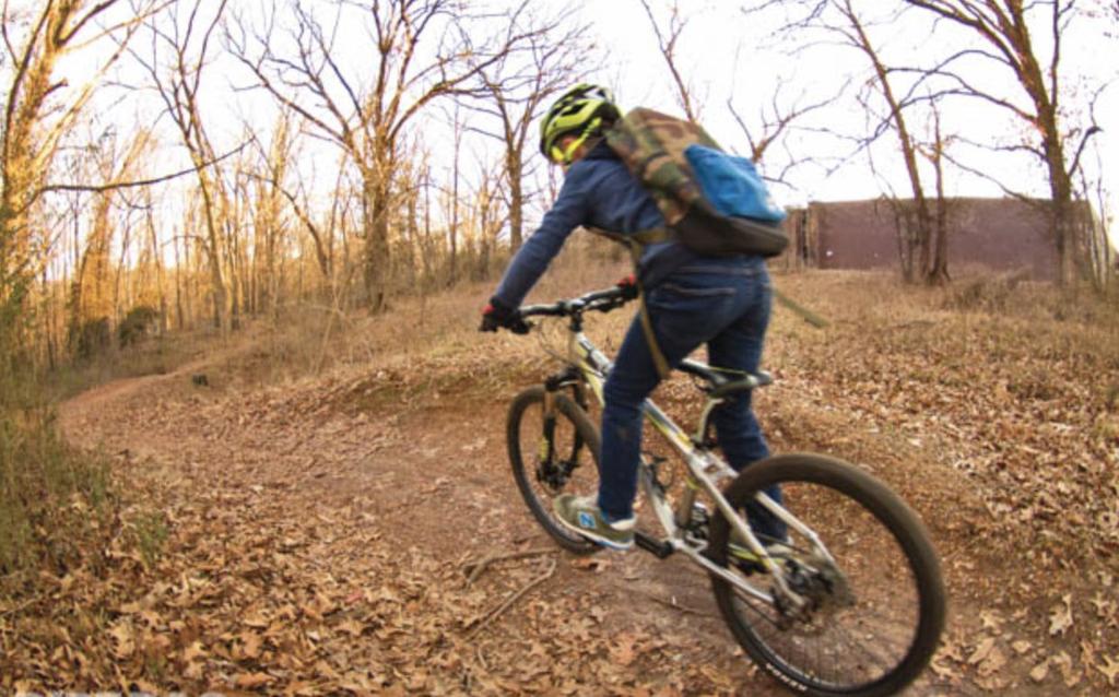
1 TO: Golden Parks, Recreation and Museums Advisory Board FR: Al Head & Ben Davis, Golden Giddyup Tim Waters & Jerry Harcek, Golden Community Members RE: Singletrack Sidewalks Pilot Proposal 3.0, January, 2018 update Thank you again for your interest in working with community members to build singletrack sidewalks in Golden. We are very grateful for your support in taking this process to the next steps. As requested, we have gone out on site and are providing much more specific alignments. We walked all of the terrain in question with an inclinometer and in all instances strive to keep the trail at no more than a 5-6% grade, meeting the goals to have a green level trail that would be accessible and fun for beginners on up. While investigating the terrain, we made several adjustments to the alignments we had originally proposed. These changes were typically due to a combination of factors, including already existing social trails in the area, identifying the best, most interesting terrain with the lowest impact, and, of course, safety. Each picture below has a brief explanation of the alignment. Please review and feel free to send any questions you might have. We would be excited to take a group out to walk the alignment in person so you can see what an amazing, and relatively low-cost amenity this would be to our community. The terrain is spectacular. We welcome your input and are anxious to move towards next steps as soon as possible. (For review) Project: Starting with a community trail at the Apex trailhead and running the length of the bike path to Heritage Dells Park, passing Shelton Elementary School, and then reconnecting at the bottom of Tripp Ranch Road before continuing past the first tunnel beneath Eagle Ridge Drive and down towards the tunnel under 6th Ave. At the request of Mayor Marjorie Sloan, we have also included a feeder trail that would connect the communities east of Heritage Rd, including the Golden Terrace, Zeta St, and Golden Ridge communities, all of which have high populations of youth attending Shelton Elementary. Design Notes: In this proposal phase we sketched trail alignments that we believed would bring added value to community activities, meet local desires for green, beginner-level trails and connect existing trail systems. We fully expect these proposed alignments will need to be assessed for their impacts on the environment and put out for public comment from local residents. In our vision, these trails are multi-use, packed-dirt trails with alternate lines for simple, beginner features made of rock and wood. They are built to offer all riders an opportunity to try their bike
2 on a natural surface trail, regardless of age or skill. And, most importantly, they are fun. Fun to ride. Fun to experience with other family members. And fun to maintain. We encourage and can arrange a trip to Valmont for anyone curious to see examples in person. Valmont s Skills Loop and Dirt 101 trails are great examples of fun, beginner level trails built for all ages. Volunteer Resources: As we ve mentioned before, the Golden Giddyup has attracted hundreds of volunteers from the community in the last several years, logging thousands of volunteer hours to build and improve local trails. In the last nine months alone, over 300 volunteers have logged over 3,200 hours on nearly 120 project days (doubling the 2017 numbers from our initial proposal submitted in July of this year). We believe the people of Golden will continue to come out in support of this project to improve their neighborhood amenities, and we will put our resources (and backs) to work to ensure that the project has local support for assistance in building and maintenance. Financial Support: The Golden Giddyup is prepared to partner with the City of Golden financially in funding the construction of these trails and trail features. It is important to note that this commitment is made possible by the 500 annual Giddyup participants, REI-Coop of Denver, Yeti Cycles, and additional Golden Giddyup sponsors. Timeline : The Golden Giddyup Trail Team is prepared to dedicate resources to this endeavor as soon as approval is granted by the City of Golden.
3 Update on Trail Alignments (January, 2018): 1. From Apex Parking lot, North towards Heritage Dells Park. There is an existing social trail on the east side of the Kinney Run bike path that follows the rock outcropping and is used by many local residents and kids. For this reason, we moved the alignment to the east side of the path throughout. 2. For the trail connecting Zeta St and surrounding communities, there are also social trails through the land between the Bachman property and the condo developments. Connecting into the roundabout at Kimball and following Heritage on the east side also provides the most access as well as the safest routes for crossing Heritage (including the pedestrian bridge just north of 4th ave).

4 Aspect 1: 2. From Kimball, through Heritage Dells Park/ Shelton Elementary towards Crawford/ Tripp Ranch Rd.

5


6 Aspect 2: 3. From Tripp Ranch Rd to Eagle Ridge Dr. Again, there is existing social trail along much of this corridor. The terrain is spectacular, but we would need to re-join the bike path before the brick oven historical site.:

7 4. From Eagle Ridge Rd to 6th Ave. This stretch has no neighbors/ residents adjacent.:

8 Example of STS in Breckenridge and Arkansas:


9 Examples of Alternate lines with Skills features (from Valmont Bike Park in Boulder):

10 Engaging the community in the process creates buy-in, ownership, and a sense of pride and accomplishment.

11 Other resources on Singletrack Sidewalk initiatives and their positive impact on local communities: -fun-eagle-colo/ ng-future/
This document is being shared by the Parks, Recreation and Musuem Advisory Board at the request of Golden citizens and in order to be transparent
 This document is being shared by the Parks, Recreation and Musuem Advisory Board at the request of Golden citizens and in order to be transparent about what documents and information was shared during
OR MISSION TRAIL ELEMENTARY
 Leawood: overview OVERLAD PARK 24: p.70 I-LA PARK 32: p.72 TOMAHAWK PARK 23: p.69 31: p.71 GEZER PARK OR MISSIO TRAIL ELEMETARY 22: p.68 W 133rd St W 135th St KASAS CITY MO - other segments Beginning/end
MEETING MINUTES District 1 Trail Planning Meeting 1
 MEETING MINUTES District 1 Trail Planning Meeting 1 June 1, 2017 2:00 PM 3:30 PM City of Two Harbors 2:00 Introductions Attendees: Lisa Austin, MnDOT Bryan Anderson, MnDOT Jasna Hadzic-Stanek, MnDOT Justin
NEW MEADOWS PARK PROPOSED MASTER PLAN
 NEW MEADOWS PARK PROPOSED MASTER PLAN A vision for your neighborhood park, the draft master plan is ready for your review. Tuesday September 12 th, 2017 5:30-7:00 PM Hellgate School District #4 middle
Macleod Trail Corridor Study. Welcome. Macleod Trail Corridor Study Open House. Presentation of Proposed Design Concepts
 Macleod Trail Corridor Study Welcome Macleod Trail Corridor Study Open House Presentation of Proposed Design Concepts Study Purpose Develop a corridor plan for Macleod Trail that aligns with The City s:
Trail Phasing Plan. Note: Trails in the Clear Creek Canyon area (Segments will be finalized in the future to minimize wildlife impacts
 Note: Trails in the Clear Creek Canyon area (Segments 2 5 and a future JCOS connection) will be finalized in the future to minimize wildlife impacts Trail Phasing Plan P Parking 3 Easy Trail Intermediate
Hudson Highlands Fjord Trail Draft Master Plan. April 29, 2015
 Hudson Highlands Fjord Trail Draft Master Plan April 29, 2015 Agenda Route Overview Proposed Segment Results of Community Survey on that Segment Next Steps Municipal Endorsement Environmental Review Implementation
Citrus Heights Creek Corridor Trail Project Trail Advisory Group Field Trip #2 September 11, :00 11:00 am Trellis Hall, Citrus Heights
 September 11, 2013 9:00 11:00 am Trellis Hall, Citrus Heights Project Overview The City of Citrus Heights is studying the feasibility of establishing a multi use trail system within the City s 26 miles
Crystal City Station Improvements. Project Overview. Table 2: North Entrance. Table 1: South Entrance. 20th St. S 18th St. S.
 Table 1: South Entrance Table 2: North Entrance 20th St. S 18th St. S Proposed Second Entrance Crystal Drive Existing Station Location Platform Future 4 th Track Future New Airport Connection (by others)
CITY OF GOLDEN PARKS AND RECREATION ADVISORY BOARD REGULAR MEETING TUESDAY, JUNE 19, :00 P.M.
 CITY OF GOLDEN PARKS AND RECREATION ADVISORY BOARD REGULAR MEETING TUESDAY, JUNE 19, 2012 7:00 P.M. PRESENT: ABSENT: STAFF: PUBLIC: Jerry Hodgden Peter Gotseff Laura Weinberg Torsten Lyon Jerry Harcek
Regional Wayfinding Sign Strategy Thurston County Trails 2017
 Regional Wayfinding Sign Strategy Thurston County Trails 2017 Partners: Members and partnering organizations of the Thurston Thrives Community Design Action Team City of Lacey, City of Olympia, City of
#1. Why is the City doing this project?
 Community Workshop #2 January 2016 #1. Why is the City doing this project? Broadway and Lincoln are in constant change Broadway and Lincoln are in constant change Broadway and Lincoln are in constant change
ONONDAGA CREEKWALK PHASE II. Public Information Meeting Series 1
 ONONDAGA CREEKWALK PHASE II Public Information Meeting Series 1 Andrew Maxwell Director, Syracuse-Onondaga County Planning Agency Owen Kerney Assistant Director for City Planning Russell Houck, PE City
Trail # NW Tuesday, June DESIGN. Provide an Review the Provide an. Project Goals: System system. wayfinding
 I. Welcome / Introductions Bethany Creek Trail #2 Segment 3 Neighborhood Meeting #1 Bethany Presbyterian Church 15505 NW Springville Road, Portland, OR 97229 Tuesday, June 26, 2018 @ 6:00PM Meeting Minutes
EP8.2 Presentation Exhibition GO Station Improvements
 EP8.2 Presentation Exhibition GO Station Improvements JANUARY 30, 2018 WORKING TOGETHER Metrolinx is working collaboratively with the City of Toronto, Exhibition Place, and the TTC to co-ordinate efforts
Northeast Quadrant Distinctive Features
 NORTHEAST QUADRANT Northeast Quadrant Distinctive Features LAND USE The Northeast Quadrant includes all the area within the planning area that is east of Interstate 5 and to the north of State Route 44.
Bonita to Bridgeport January 24, 2019
 Thank you for participating 6:00-6:05 Welcome 6:05-6:55 Presentation; clarifying questions 7:00-7:30 Talk with staff; write comments Concerns with Locally Preferred Alternative (LPA) route between Bonita
Longmont to Boulder Regional Trail Jay Road Connection DRAFT FINAL REPORT
 Longmont to Boulder Regional Trail Jay Road Connection DRAFT FINAL REPORT December 2018 Project Summary Boulder County, Colorado, in partnership with the City of Boulder, is evaluating options for multi-use
CITY COUNCIL AGENDA MEMORANDUM
 To: Mayor and City Council From: Charles Ozaki, City and County Manager Prepared By: Kevin Standbridge, Deputy City and County Manager Katie Allen, City and County Engineer David Shinneman, Community Development
Villages at Buffalo Run East
 Villages at Buffalo Run East Neighborhood Park Subhead to title page goes here. Public Design Meeting April 9, 2015 Capital Improvement Program Commerce City s $137 million CIP is the result of a 2013
Chatsworth Branch Library Devonshire Street, Chatsworth, CA Thursday, November 16, :00-8:00 pm
 Chatsworth Branch Library 21052 Devonshire Street, Chatsworth, CA 91311 Thursday, November 16, 2017 6:00-8:00 pm Project Team County of Los Angeles Department of Parks and Recreation Kathline King Chief
Steps in the Management Planning Process
 Steps in the Management Planning Process Developing a management plan for Kalamalka Lake Park will follow a multi-stage process. The planning process for this park is currently in the Draft Management
Stevenson Ranch Library The Old Road, Stevenson Ranch, CA Thursday, November 9, :00-8:00 pm
 Stevenson Ranch Library 25950 The Old Road, Stevenson Ranch, CA 91381 Thursday, November 9, 2017 6:00-8:00 pm Project Team County of Los Angeles Department of Parks and Recreation Kathline King Chief of
Committee. Presentation Outline
 CW-33-15 11/9/2015 Community and Corporate Services Committee November 10, 2015 1 Presentation Outline Background Vision and Objectives Study Process and Timeline Public and Stakeholder Engagement Organization
China Creek North Park Upgrades and Glen Pump Station. Park Board Committee Meeting Monday, July 10, 2017
 China Creek North Park Upgrades and Glen Pump Station Park Board Committee Meeting Monday, July 10, 2017 Purpose The purpose of this presentation is to: Share the results of the public engagement processes;
Non-motorized Trail Plan & Proposal. August 8, 2014
 Town of Star Valley Ranch, Wyoming and the Star Valley Ranch Association in partnership with the USDA Forest Service, Bridger-Teton National Forest, Greys River Ranger District Non-motorized Trail Plan
Auburn Trail / Ontario Pathways Trail Connector Feasibility Study Public Information Meeting Wednesday, August 22, 2012
 Auburn Trail / Ontario Pathways Trail Connector Feasibility Study Public Information Meeting Wednesday, August 22, 2012 Purpose of Feasibility Study Purpose Evaluate the feasibility of constructing a multiuse
Raytown: overview. map. Santa Fe, Oregon, and California National Historic Trails KANSAS CITY KANSAS CITY. 38 Trail alignments: Raytown.
 Raytown: overview Blue Ridge Cut-off map 18: p.42 RICE- TREMOTI HOME Raytown Tfwy KASAS 17: p.41 JUCTIO WITH ROCK ISLAD LIE RIGHT OF WAY 16: p.40 BUS STOP AT E 51ST AD BLUE RIDGE (KASAS ) Sterling Ave
ST. CLOUD LAKE WOBEGON TRAIL OPEN HOUSE
 ST. CLOUD LAKE WOBEGON TRAIL OPEN HOUSE PROJECT INTRODUCTION Project partners: St. Cloud Area Planning Organiza on (APO) and the City of St. Cloud. The project area is approximately 2.5 miles long, extending
The Vision for the San Juan Islands Scenic Byway
 The Vision for the San Juan Islands Scenic Byway 2 Judd Cove, Orcas Island, Courtesy of Kurt Thorson (kurtthorson.com) and San Juan County Land Bank Vision for the San Juan Islands Scenic Byway The San
The Chu property is a 6.57 acre parcel located in the Town of Superior on the west side of McCaslin Boulevard. In 2014, the Town of Superior acquired
 1 The Chu property is a 6.57 acre parcel located in the Town of Superior on the west side of McCaslin Boulevard. In 2014, the Town of Superior acquired the Chu property for open space with a contribution
A VISION FOR EL MIRAGE
 el mirage A VISION FOR EL MIRAGE OASIS, ARIZONA A thriving desert jewel destination with a strong arts district, high-wage employment parks system joined together by cohesive, multi-use accessible trails
Attendance Presentation
 TO The Community of Saanich FROM District of Saanich DATE January 30, 2017 RE Meeting Notes Haro Woods Jan 28th Community Engagement Goward House, 2495 Arbutus Road, Victoria BC Attendance In total, 18
Welcome to the Cross County Trail Public Input Session!
 Welcome to the Cross County Trail Public Input Session! Please sign in on the table below! What are we doing here? Camden County has proposed a bicycle and pedestrian trail spanning across the entire county.
A CASE FOR COMPLETING THE JORDAN RIVER PARKWAY: A
 A CASE FOR COMPLETING THE JORDAN RIVER PARKWAY: A safe crossing at 9000 South and 850 West Proposed 9000 South Underpass Parkway Timeline Parkway, Trail, and Tourism Facts Blueprint Jordan River 1971 1973
Paiute Trail Hatfield-McCoy Highwood Mountains
 Paiute Trail Hatfield-McCoy Highwood Mountains Located in Central Utah Main trail is 238 miles 550 miles of designated side trails Links 16 communities in 4 counties Ranges from 5,200 to 11,500 feet Great
Dover Park Master Plan. Community Design Event Tuesday, May 22, 5 7 pm
 Dover Park Master Plan Community Design Event Tuesday, May 22, 5 7 pm Agenda I. Introduction / Overview 20 minutes II. Small Group Design Activity 60 minutes III. Small Group Report Out IV. Conclusion
BICYCLING WITH KIDS: LONG DISTANCE RIDES FROM BELOIT TO SUPERIOR
 Newsletter OVER 20 YEARS OF ROCK TRAIL ADVOCACY August 2014. Please join us for our next meeting! BICYCLING WITH KIDS: LONG DISTANCE RIDES FROM BELOIT TO SUPERIOR by Troy Knudson Thursday October 26 th
COASTAL CONSERVANCY. Staff Recommendation December 2, 2004 COYOTE HELLYER COUNTY PARK BAY AREA RIDGE TRAIL
 COASTAL CONSERVANCY Staff Recommendation December 2, 2004 COYOTE HELLYER COUNTY PARK BAY AREA RIDGE TRAIL File No. 04-057 Project Manager: Amy Hutzel RECOMMENDED ACTION: Authorization to disburse up to
BRYAN REGIONAL PARK. Presented by: Burditt Consultants November 13, 2018
 BRYAN REGIONAL PARK Presented by: Burditt Consultants November 13, 2018 AGENDA 1. Project Purpose & Mission 2. Project Vision & Goals 3. Stakeholder Feedback 4. Program Overview 5. Phase A Plan Overview
Proposed Peninsula Bay Bike Track Development
 Proposed Peninsula Bay Bike Track Development May 2018 BACKGROUND The area of land at the northern extreme of Wanaka's Peninsula Bay development (Lot 923 DP 501325), currently owned by Infinity Investment
6. How connected do you feel to the Sans Souci community?
 Please complete and return before May 1st, 2017, to be entered for a prize drawing. Further instructions are available on the last page. Digital version available at GCPlanning.org. 1. Do you live and/or
Welcome to the Future Kingston Point Rail Trail!
 Welcome to the Future Kingston Point Rail Trail! Today s tour will introduce the proposals for a linear park and non-motorized trail along a 1.5 mile stretch of the former Ulster & Delaware Railroad, from
Thank you for the opportunity to comment on the proposed action to add trails and trailheads to the Red Rock District trail system.
 July 14, 2010 Jennifer Burns Red Rock Ranger District PO Box 20429 Sedona, AZ 86341 Flagstaff Biking Organization PO Box 23851 Flagstaff, AZ 86002 Dear Jennifer- Thank you for the opportunity to comment
Public Comment. Comment To consider extending State Park lands above River Mile 7.0
 Public To consider extending Park lands above River Mile 7.0 on the Little Spokane River for the conservation and limited recreation qualities they contain is this request. Could this be included in your
Mohawk Hudson Bike Hike Trail Crossroad Connection Study
 Summary Report - April 21, 2003 Mohawk Hudson Bike Hike Trail Crossroad Connection Study Summary Report Introduction The Capital District Transportation Committee (CDTC), in partnership with Albany County,
Port Gamble Shoreline Area Conceptual Trail Proposal
 The North Kitsap Trails Association is pleased to be a partner to the Kitsap Forest and Bay Project and assist Kitsap County, Forterra, Olympic Property Group, Great Peninsula Conservancy and the Port
Rapid Transit From Arbutus Street to UBC. Policy and Strategic Priorities Council Meeting January 30, 2019
 Rapid Transit From Arbutus Street to UBC Policy and Strategic Priorities Council Meeting January 30, 2019 Agenda 1. A History of Planning for Broadway Rapid Transit 2. The Need for Broadway Rapid Transit
!" # $ % & % ' ( '' ) ) ) ) )
 ) ) ) )") !" #$% &% ' ( ')) ))) #% * % ) +#% *- *,% ) Trails Attract Business, Residents and Tourists National Association of Homebuilders 0% 20% 40% 60% % of What People Desired Exercise Facilities Proximity to
!" #$% &% ' ( ')) ))) #% * % ) +#% *- *,% ) Trails Attract Business, Residents and Tourists National Association of Homebuilders 0% 20% 40% 60% % of What People Desired Exercise Facilities Proximity to
Conexus is committed to innovation and bringing financial services to market with speed. We have a long history of innovation, including:
 Corporate Profile Saskatchewan's largest and Canada's sixth largest credit union, Conexus has been serving its members for over 80 years. Today we manage more than $7.14 billion in funds and our 900 plus
PIONEER PARK. City of Des Peres Parks Master Plan. SWT Design 46 INTRODUCTION
 PIONEER PARK INTRODUCTION Pioneer Park is a 7 acre neighborhood park located east of Interstate 270 and south of Manchester Road along Tallie Road. The park is situated in a residential neighborhood with
ANCLOTE COASTAL TRAIL ALTERNATIVES ANALYSIS STUDY
 ANCLOTE COASTAL TRAIL ALTERNATIVES ANALYSIS STUDY PASCO COUNTY MPO JULY 2015 PROJECT OVERVIEW... INTRODUCTION EXECUTIVE SUMMARY CONTEXT... TAMPA BAY AREA, PINELLAS, & PASCO COUNTY S MULTI-USE TRAIL PLANS
Mendota Trail Newsletter
 Mendota Trail Newsletter FIRST MILE IS OPEN! On Saturday, October 7, 2017 supporters of the trail gathered at the Mendota Trailhead for the official grand opening of the first mile. A few well-placed words,
Community Advisory Committee Meeting #3 April 21, 2015
 Community Advisory Committee Meeting #3 April 21, 2015 Purpose (charge) of the CAC: Be Knowledgeable, Be an Engaged Representative, Develop Master Plan, & Prioritize Plan 1 Welcome/ Introductions Review
Growing up Boulder. Highlights from the Past Year
 Growing up Boulder S U M M E R 2 0 1 4 A N N U A L R E P O R T Highlights from the Past Year Growing Up Boulder (GUB) has actively engaged young people in a number of planning and design projects to increase
FEASIBILITY CRITERIA
 This chapter describes the methodology and criteria used to evaluate the feasibility of developing trails throughout the study areas. Land availability, habitat sensitivity, roadway crossings and on-street
Rivanna Trails Foundation
 a project of the Rivanna Trails Foundation Source www.rivanna.avenue.org Who we are The mission of the Rivanna Trails Foundation (RTF) is to create, promote the creation of, and protect footpaths, trails
ADVENTURE PLAN EXPLORE PARK
 ADVENTURE PLAN ROANOKE COUNTY S EXPLORE PARK ROANOKE COUNTY PARKS, RECREATION AND TOURISM 1206 KESSLER MILL RD SALEM, VA 24153 (540) 387-6078 WHAT S INCLUDED? Explore Park Adventure Plan - Guided by extensive
This section provides the basic information about the park or trail and the organizations responsible for it. Funding Application F
 General This section provides the basic information about the park or trail and the organizations responsible for it. Park/Trail ID # 16-43D Last Update July 13, 217 District 2 Funding Application 17-82-F
Great Wolf Lodge Fact Sheet & Frequently Asked Questions Potential Location in Gilroy, California 8/30/17
 WHAT? Great Wolf Resorts has identified Gilroy, California as a potential location for a new Great Wolf Lodge family resort and has entered into a 60-day period of exclusivity with the City and community
STEP ALTERNATIVES RANKING TABLE
 ALTERNATIVES RANKING TABLE Priority Ranking 0 = Lowest Priority 1 2 3 4 5 = Highest Priority Abbreviations TD = Transportation Disadvantaged PWD = People with Disabilities I. Existing Enhancements Increase
South Bay Metro Light Rail Extension. Summer/Fall 2017 Project Briefings
 South Bay Metro Light Rail Extension Summer/Fall 2017 Project Briefings Meeting Agenda 2 Project History Project Development Schedule Feedback 3 Project History Alternatives Analysis Measure R $272M 2008
Adopt a Trail Blue Ridge Parkway
 Adopt a Trail Blue Ridge Parkway THANK YOU Thank You for volunteering to maintain a trail with the Adopt-A-Trail program! You are helping to keep these trails open for public use and enjoyment. We couldn
The Scoop. No Tax Increase for Residents; Rates and Fees to Remain the Same Budget 2019 at a Glance. December 20, 2018
 The Scoop The Town of Conception Bay South is pleased to present the Scoop, a publication dedicated to providing residents with important information and to highlight significant Town milestones and achievements.
EXECUTIVE SUMMARY FALL Introduction. Findings
 EXECUTIVE SUMMARY FALL 2004 Introduction Trails are one of the most popular and highly desirable recreational resources in communities of all sizes throughout the country. In addition to providing a safe
KAWATHA TRANS CANADA TRAIL ADJACENT PRIVATE LAND OWNERSHIP SURVEY
 KAWATHA TRANS CANADA TRAIL ADJACENT PRIVATE LAND OWNERSHIP SURVEY Al MacPherson, President KTCTA Dr. John Marsh, Trail Studies Unit, Trent University October 2015 KAWATHA TRANS CANADA TRAIL ADJACENT PRIVATE
SAN ANTONIO RIVER IMPROVEMENTS PROJECT. August 6, 2008
 SAN ANTONIO RIVER IMPROVEMENTS PROJECT August 6, 2008 1 History of the SA River Improvements 1921 Flood Olmos Dam Complete in 1929 Downtown Flood Relief Projects in 1950 s Dams on the River Channel and
Building the transportation network we need for the future in Niagara Region
 Building the transportation network we need for the future in Niagara Region Niagara@metrolinx.com Metrolinx.com/Niagara Metrolinxengage.com INSERT FOOTER 1 WHO IS METROLINX? Metrolinx was created in 2006
Blue River Trail Master Plan JSA to Town Hall June 2004
 Blue River Trail Master Plan JSA to Town Hall June 2004 Prepared for: Silverthorne Town Council Silverthorne SPORT Committee Department of Recreation and Culture Silverthorne Public Works Silverthorne
Greenville Rec Annual Trails Report
 Greenville Rec Annual Trails Report 1 May 2011 Submitted Chaco grant at request of Mast General Store for purchase and supplying trail building tool trailer. Met with Greenville County Traffic Engineer
The Impact of Trails on Communities. Jim Wood Chief, Office of Greenways & Trails Division of Recreation and Parks
 The Impact of Trails on Communities Jim Wood Chief, Office of Greenways & Trails Division of Recreation and Parks Why Trails and Greenways? Resolution of the Florida Greenways and Trails Council Recognizing
TRAFALGAR PARK. 78: p.140 W 99th St FLAT ROCK CREEK PARK. W 103rd St OVERLAND PARK. Quivira Rd. College Blvd. Shared use path. Mountain bike trail
 Lenexa: overview TRAFALGAR PARK 78: p.140 As the Westport Route crosses over Lenexa's boundaries with Olathe and Overland Park several times, approximately 2.75 or 3 miles of the historic route of the
Header i
 Header i 048285014.10 Header Sub Title Body Text here. Body text here. Body text here. Section 1... 1 Executive Summary... 1 Opportunities and Constraints... 3 Overall Opportunities and Constraints Map
Union Station Queens Quay Transit Link Study
 Welcome Union Station in 1899. Image: City of Toronto Archives Union Station today. Image: Camil Rosiak Activity along Queens Quay. Image: Waterfront Toronto For more information or to comment, visit toronto.ca/waterfronttransit
South Bay Light Rail Extension Summer/Fall 2017 Project Briefing
 South Bay Light Rail Extension Summer/Fall 2017 Project Briefing Meeting Agenda 2 Project History Project Development Schedule Feedback Study Area Project History 4 Alternatives Analysis 2008 Measure R
AGENDA ITEM 5 D WAKULLA ENVIRONMENTAL INSTITUTE (WEI) TRAIL FEASIBILITY STUDY
 TRAIL FEASIBILITY STUDY") March 19, 2018 AGENDA ITEM 5 D WAKULLA ENVIRONMENTAL INSTITUTE (WEI) TRAIL FEASIBILITY STUDY TYPE OF ITEM: Action STATEMENT OF ISSUE The Wakulla Environmental Institute (WEI) Trail is one of several trails
March 19, 2018 AGENDA ITEM 5 D WAKULLA ENVIRONMENTAL INSTITUTE (WEI) TRAIL FEASIBILITY STUDY TYPE OF ITEM: Action STATEMENT OF ISSUE The Wakulla Environmental Institute (WEI) Trail is one of several trails
Section II. Planning & Public Process Planning for the Baker/Carver Regional Trail began in 2010 as a City of Minnetrista initiative.
 Section II Planning & Public Process Planning for the began in 2010 as a City of initiative. city staff began discussions with the Park District on the possibility of a north/south regional trail connection
Southwest Quadrant Distinctive Features
 SOUTHWEST QUADRANT Southwest Quadrant Distinctive Features LAND USE The 31.17 square mile Southwest Quadrant includes all the area within the planning area west of I-5 and south of the Sacramento River.
ETOBICOKE CREEK NORTH TRAIL PROJECT. May 18, 2017 at Michael Power High School 105 Eringate Drive, Etobicoke ON M9C 3Z7
 ETOBICOKE CREEK NORTH TRAIL PROJECT May 18, 2017 at Michael Power High School 105 Eringate Drive, Etobicoke ON M9C 3Z7 1 Purpose of Open House The purpose of today s open house is to present the design
A BOAT RAMP TO NOWHERE
 A BOAT RAMP TO NOWHERE A PROPOSAL FOR ACCESS TO HARVIE PASSAGE A Presentation to the City of Calgary December 2017 Presented by: Peter Crowe-Swords Bow River Trout Foundation Background: The Bow River
Welcome and thank you for being here! Kick-Off Public Workshop November 19, 2014
 Welcome and thank you for being here! Kick-Off Public Workshop November 19, 2014 OPEN SPACE MATTERS: Boise s First Reserve Master Plan Julia Grant Foothills and Open Space Manager City of Boise Ellen Campfield
GATEWAY PHASE 2. U.S. Forest Service and the Mount Shasta Trails Association
 GATEWAY PHASE 2 U.S. Forest Service and the Mount Shasta Trails Association PROJECT DEVELOPMENT Brief history - Gateway Phase 1 - IMBA conceptual plan - BikeShasta: concert series - USFS & MSTA partnered
 288.075, F.S. Florida Job Growth Infrastructure Application Response to Question 1A Provide the title and a detailed description of the public infrastructure improvements. The West River Riverwalk
Waukee Trailhead Public Art and Amenities Project
 Waukee - Trailhead Public Art and Amenities Project Sponsor Waukee Project Title Waukee Trailhead Public Art and Amenities Project Termini Description ( i.e. Park Avenue to 19th Street) NE Intersection
City Council Workshop July 26, 2010
 Des Moines Trails Connecting a Community City Council Workshop July 26, 2010 1 OVERVIEW Trail Benefits Trails Progress How We Fund Trails What s Next for Trails 2 What is a trail? Paved Trails 10 wide
Abbott Rd Rehabilitation Phase II - Elmore Rd to Birch Rd
 Abbott Rd Rehabilitation Phase II - Elmore Rd to Birch Rd Project ID SOA07003 Department State of Alaska Project Type Improvement Start Date December 2017 Location Assembly: Section 4, Seats F & G, Assembly:
Experience the environment
 Experience it. Experience the environment The Grand is where CREATIVE, STATE-OF-THE-ART OFFICE meets inviting outdoor spaces featuring vibrant landscaping, pedestrian walkways and a two acre PROMINENT
City of Madison, Buckeye Road Monona Drive to Stoughton Road County AB Dane County Public Involvement Meeting
 City of Madison, Buckeye Road Monona Drive to Stoughton Road County AB Dane County Public Involvement Meeting Wednesday, May 31, 2017 6:30 to 8 P.M. Frank Allis Elementary School 4201 Buckeye Road Madison,
Why we re here: For educational purposes only
 Transportation 2050 Why we re here: For educational purposes only Transportation 2050 Bus Elements PUBLIC TRANSIT DEPARTMENT City of Phoenix Citizens Committee on the Future of Phoenix Transportation (CCFPT)
FINCH HYDRO CORRIDOR TRAIL PROJECT
 FINCH HYDRO CORRIDOR TRAIL PROJECT Pharmacy Avenue to Birchmount Road January 29 th, 2018 L Amoreaux Community Centre (2000 McNicoll Avenue) 1 Purpose of Drop In Event The purpose of today s drop-in event
City of Durango 5.8 FUNDING TRAILS DEVELOPMENT
 5.8 FUNDING TRAILS DEVELOPMENT The City has been successful in establishing dedicated local funding sources as well as applying for grants to develop the City s trail system, having received nearly $2.4
DRAFT - APRIL 13, 2007 ROUTING STUDY FOR TRAIL CONNECTIONS BETWEEN CALAIS AND AYERS JUNCTION
 DRAFT - APRIL 13, 2007 ROUTING STUDY FOR TRAIL CONNECTIONS BETWEEN CALAIS AND AYERS JUNCTION Abstract The vision for the East Coast Greenway is an off-road urban trail system running from Calais, Maine
Damen Elston Fullerton Reconstruction, Intersection Improvements CDOT Project B-1-501
 Damen Elston Fullerton Reconstruction, Intersection Improvements CDOT Project B-1-501 Bird s Eye View of Existing INTRODUCTION This project is part of the City s Building a New Chicago initiative in conjunction
Pilot Focus Group. March 31, :30 AM 10:00 AM. Meeting Minutes
 Pilot Focus Group March 31, 2015 8:30 AM 10:00 AM Meeting Minutes Attendees: Dennis Butterfield, Harvey Field/Based Pilot Terry Chamberlain, Harvey Field/Based Pilot Melanie Hancock, Snohomish Flying/Based
Georgetown-Lewes Rail/Trail Study. Rail/Trail Study: Cool Spring to Cape Henlopen State Park New Road Extension (House Resolution No.
 Georgetown-Lewes Rail/Trail Study Rail/Trail Study: Cool Spring to Cape Henlopen State Park New Road Extension (House Resolution No. 47) August 22, 2011 Presentation Outline Background Benefits Statewide
September 14, Comments of the Colorado Trail Foundation On the USFS Scoping Notice of August 13, 2010 RE: the relocation of the CDNST/CT Page 1
 THE COLORADO TRAIL FOUNDATION Comments on the U.S. Forest Service Scoping Notice of August 13, 2010 Regarding the Relocation of THE COLORADO TRAIL AND CONTINENTAL DIVIDE NATIONAL SCENIC TRAIL From La Garita
South Canon City Center
 South Canon City Center Canon City s Golden Triangle Thank you, Mr. Mayor, City Council and City Administration, for the opportunity to address you. I have a vision to share with you, regarding the recovery
Staff Report Sign Design
 Staff Report Sign Design July 29, 2014 Planning & Zoning Commission Meeting Report date July 23, 2014 Project type Sign Design Legal description Section 2, Township 5, Range 82 Lots 3&4, S1/2NW1/4, SW1/4
January 14, Orange County Transportation Authority Attn: M2 NCCP/HCP 550 South Main Street P.O. Box Orange, CA
 Equestrian Trails, Inc. Corral 357 P.O. Box 1026 Trabuco Canyon, CA 92678 http://saddlebackcanyonriders.com/ President: James Iacono... 714-612-1789 January 14, 2016 Orange County Transportation Authority
Coast to Coast Connector Summit
 Project Partners Welcome to the Coast to Coast Connector Summit Winter Garden, Florida City Hall October 1, 2014 1 Why are we here? Objectives 1. Inform key stakeholders on the current state of the C2C