Decision Notice and Finding of No Significant Impact
|
|
|
- Barrie Haynes
- 5 years ago
- Views:
Transcription
1 Decision Notice and Finding of No Significant Impact Steamboat Ski Area Summer Trails Project USDA Forest Service Medicine Bow-Routt National Forests Hahns Peak/Bears Ears Ranger District Routt County, Colorado Lead Agency Responsible Official For more information, contact: USDA Forest Service Phil Cruz, Forest Supervisor Medicine Bow-Routt National Forests & Thunder Basin National Grassland 2468 Jackson Street Laramie, WY (307) Kent Foster, Team Leader Hahns Peak/Bears Ears Ranger District Routt National Forest 925 Weiss Drive Steamboat Springs, CO (970) This document is available on the Internet at under Steamboat Ski Area Summer Trails Project 1
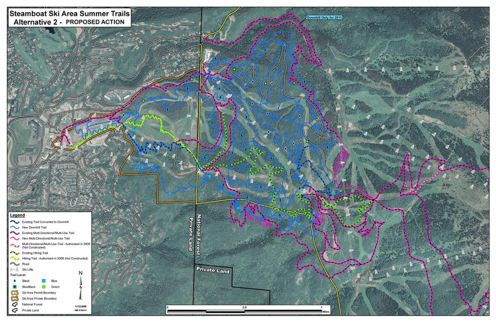
2 Decision and Reasons for the Decision Background The Steamboat Ski & Resort Corporation (SS&RC) operates under a Forest Service special use permit, first issued in The ski area s summer trail system was first developed in 1982 and new trails have been constructed periodically since that time. Approximately 29 miles of trails were designed and currently provide opportunities for mountain biking, hiking, and horseback riding. To continue the development of Steamboat Ski Area as a premier, four-season resort, and to meet the increasing demands for summer uses, specifically addressing the growing popularity of downhill/free ride mountain biking, a comprehensive trails plan was proposed by SS&RC. An updated Summer Trails Master Plan was accepted by the Forest Service in July, In September 2010, the Medicine Bow/Routt National Forests (Forest) received a proposal from SS&RC to construct new summer trails and change the use of some existing trails as described in this updated plan. Mountain biking is an important part of the summer recreation base in Steamboat Springs. The trails within the ski area s summer operational boundary are part of a larger network of trails in the Steamboat area that provide opportunities for multi-use/multi-directional (cross-country) opportunities on City, BLM, Federal, and private (SS&RC) lands. Downhill (DH) mountain biking is increasing in popularity locally and nation-wide and is sometimes not compatible with all other trail uses. The Steamboat Ski Area had approximately 28,000 summer visitors on the gondola in Purchased mountain bike passes increased by more than 1,000 in 2010, as compared to 2008 and Cross-country mountain biking on the trail system continues to increase with users accessing the mountain during and after hours of lift operations. Several mountain bike and running events occur within and adjacent to the Steamboat Ski Area and depend heavily on the recreational trail system and nearby National Forest System Trails (NFSTs). The demand for similar recreational events is expected to increase in response to population growth in Colorado, notwithstanding the normal increase in use by the general public. Decision Based on my review of all alternatives, I have decided to implement Alternative 2 Proposed Action -Modified, as described in the EA (June 2011). This alternative proposes up to 36 miles of new trail construction;15 miles machine-built, and 21 miles hand-built. All monitoring requirements and design criteria listed in Appendix A of the EA will be followed. Monitoring requirements are also listed in this Decision Notice (DN). It is also my decision to authorize Amendment 1 from Alternative 2 in the EA. Amendment 1 from alternative 2, changes in Management Area 5.41 Recreation Standard 2 which reads Do not allow construction of new recreation facilities. This standard is amended by waiving the standard entirely to allow for construction of summer trails within the area covered by the Steamboat Ski Area Summer Trails EA Amendment 1. 2
3 This is not an amendment to change land use or Forest Plan Management, only to modify a standard to allow existing uses to continue in a portion of the specific MA. Monitoring of new and existing trails will determine effectiveness of design criteria in minimizing potential adverse effects to soil and water resources, and results will determine if more future trail development can occur. Minor watershed improvement opportunities such as road surfacing, creating sediment traps on existing travel ways, and other erosion control measures to reduce the effects of existing roads and trails have been identified and would be implemented. Specific projects to be implemented include those listed in the description of Alternative 2 Modified in the EA, pages A summary of the projects include: Mountain Bike Trails: New Trails Blue/Intermediate Trail DH only New Black/Advanced Trail DH only Blue Jump Trail DH only Green/Beginner Trail (on private SS&RC land)-dh only Green DH only Zig Zag New segment multi-directional/multi-use Valley View new segment multi-directional/multi-use Additional Trails 10 to 12 trail and trail segments would be built in the DH trail zone Converted - DH-only Trails Yoo Hoo Trail (from the top of See Ya to the base area). Creekside Trail: Commensurate with the 2011 summer operating season, Creekside Trail would be designated as a DH-only mountain bike trail until the first DH-only trail is completed, and then it would revert back to a multi-directional/multi-use trail. Multi-Use trails to be Eliminated from the Trail System The Shortcut Trail would be eliminated. Yoo Hoo Trail/Road would be eliminated. Actions to Improve Watershed Condition: Multi-Use trails to be Eliminated from the Trail System The Shortcut Trail would be eliminated. Yoo Hoo Trail/Road would be eliminated. Existing Trail Reroutes and Improvements to improve alignment and drainage. Zig Zag Trail at Vagabond Sunshine Trail under lift line Valley View Trail at Boulevard 3
4 Valley View stream crossing bridge. Road Improvements gravel/surfacing or roads, improving erosion control. Road between base of Storm Peak lift and Pony Express lift. So What Road near Burgess Creek. Why Not Road by Tower 3. Shortcut Road. When compared to other alternatives, Alternative 2 best meets the purpose and need as described below, and addresses significant issues. It maintains trail access and connectivity from public and private lands to SS&RCs trail system. The new downhill-only mountain bike trail construction and designations will reduce existing user conflicts and improve safety issues while providing a variety of summer recreational trail opportunities and skill levels within the trail system. Alternative 3 was developed to address the potential for adverse cumulative watershed impacts to the Burgess Creek and Priest Creek watersheds, however, reduced miles of trail proposed does not meet the purpose and need as completely. To avoid the potential adverse effects to watershed health attributes that led to the development of Alternative 3, Alternative 2 will be implemented in the following manner: Trails will be constructed using a phased approach as described in the EA, with two trails constructed in 2011, and other trails built in subsequent years upon approval of design, trail management objectives and other clearance requirements. Monitoring will be done on newly constructed trails and construction of new trails can continue until monitoring identifies adverse watershed effects are occurring. If specified monitoring determines design criteria and implementation to protect the soil and water resources are effective, the other trails would be built. If results show adverse effects, trail construction will cease. The Forest Service and SS&RC will periodically assess and monitor implementation of the project considering all resources. Upon completion of 20 miles of trail, a monitoring report will document findings. Opportunities to reduce the effects of existing roads and trails have also been identified and would be implemented before or concurrently with trail development. Important considerations that influenced my decision included how well it responded to the Purpose and Need for Action (EA pages 3-4) and comments received from the public during both 30 day scoping and formal comment periods. Prior to making my decision, I reviewed information from the following sources: The analysis described in the EA and associated project record. Comments received on the proposed action and alternatives analyzed. Routt National Forest Land and Resource Management Plan, 1997 Revision (Forest Plan). 4
5 Purpose and Need for Action The purpose of this project is to encourage and maintain a safe and enjoyable recreational experience, while providing trails and management strategies that offer opportunities for all types of trails users. This action is needed to meet the current and predicted increase in the popularity of ski areas as summer recreational destinations, and the increase and change in mountain biking uses. The development of a comprehensive trail plan identified the need that includes designating trails for particular uses and adding trails to address new technology related to mountain biking. Mountain bikers, especially the downhill rider user group, typically travel at higher rates of speed, and are not always fully compatible with other uses, such as horseback riding, hiking, or even cross-country mountain biking (uphill riding). Currently, all utilize the same existing trail system. Additionally, new trails are being created without authorization both inside and outside the permit area. These user-created trails generally do not meet sustainable environmental standards and lead to unacceptable resource impacts. The specific objectives of this project are: Reduce the potential for collisions, risk of injury, and to avoid conflict between users. Provide a variety of DH-only mountain bike trails, accessed by the ski area lifts, for the novice to the experienced rider, including technical trail features. Continue to offer cross-country mountain biking, hiking, and horseback riding opportunities and access to trails beyond the ski area boundary. Ensure trails are built to be environmentally sustainable over time and can be maintained with minimal cost. Reduce the unauthorized user-created mountain bike trail construction currently taking place within the ski area boundary and in other areas on the Routt National Forest. Other Alternatives Considered In addition to the selected alternative, two other alternatives were considered. Alternative 1: No Action Under the No Action Alternative, current management would continue in the project area. Previously approved trails projects would be implemented as authorized in the Decision Notice of the Environmental Assessment of Proposed Improvements at Steamboat Ski Area (May 2006). The Thunderhead Hiking Trial connection and the Storm Peak Challenge/Sunshine connector multi-use trail would be constructed, and improvements to the Zig Zag Trail would be completed. No new DH-only, cross-country mountain biking, or hiking trails would be built, and unauthorized trail construction would likely continue to impact resources. Alternative 3 Watershed Management This alternative was developed to address the significant issue of the potential for adverse cumulative soil and watershed effects in the Burgess Creek and Priest Creek watersheds; while still meeting the purpose and need for the project. This alternative proposed construction of up to 20 miles of new trail; approximately 15 miles machine-built, and 5 miles hand-built. 5
6 Approximately 1.2 miles of new DH-only mountain bike trails were proposed and designed outside the ski area permit boundary. Public Involvement The proposal was first listed in the Schedule of Proposed Actions on September 26, The proposal was also provided to the public and other agencies to solicit formal comments (comment period - September 26 to October 25, 2010) through a legal notice published in the newspaper of record (The Laramie Boomerang) on September 26, Additionally, a press release was provided to the Steamboat Pilot and published on September 23, Based on comments received and the analysis process, the SS&RC s initial proposal was slightly modified. In response to Forest Service resource concerns, design criteria, and monitoring measures, a third alternative was also developed. To be consistent with Forest Plan standards, a site-specific amendment to the Forest Plan is needed to address the construction of trails, considered recreational facilities, specifically within Deer and Elk Winter Range (Management Area Prescription 5.41). Because of these identified changes, the Forest Service decided to request additional input from the public. A second scoping letter was listed in the Schedule of Proposed Actions on March 27, A legal notice was also published in the newspaper of record (The Laramie Boomerang) on March 27, Furthermore, to allow public comment from the local community affected, a press release was provided to the Steamboat Pilot and an article was published on March 31, 2011 regarding the project. The proposal was provided to the public and other agencies for additional comments during this second comment period (March 27, 2011 to April 25, 2011). These comments were also included in the EA. Finding of No Significant Impact (FONSI) After considering the environmental effects described in the EA, I have determined that these actions will not have a significant effect on the quality of the human environment considering the context and intensity of impacts (40 CFR ). Thus, an environmental impact statement will not be prepared. I base my finding on the following: 1. My finding of no significant environmental effects is not biased by the beneficial effects of the action. 2. There will be no significant effects on public health and safety, because this is a continuation of an ongoing activity that is not unique. 3. Effects to historic, prehistoric and paleontological values are also addressed in the EA. The analysis area is known to contain cultural resources; however, it is the conclusion of the District Archaeologist that Alternative 3 will have minimal effect on these resources. 4. The effects on the quality of the human environment are not likely to be highly controversial because there is no known scientific controversy over the impacts of the action. This EA is tiered to the Forest Plan Final Environment Impact Statement. The selected alternative, with design criteria, meets Forest Plan standards and guidelines. In addition, public comment was sought to identify issues of potential controversy. These issues were used to focus development of alternatives, design criteria, and the EA itself. Therefore, it is unlikely that the environmental effects associated with the action will be highly controversial. 6
7 5. We have considerable experience with the types of activities to be implemented. The effects analysis shows the effects of this decision do not involve unique or unknown risks and are similar to the effects of past similar actions. The interdisciplinary team that conducted the analysis used current literature and the results of past actions to estimate effects of the alternatives (see Literature Cited section, Appendix G in the EA). Based on these findings there are no unique or unusual characteristics about the area not previously encountered that would constitute an unknown risk upon the human environment. 6. This project does not establish precedents for future actions with unknown risks to the environment. Recreation Special Use permits authorized on the National Forest is not without precedent and is consistent with Forest Plan direction. 7. The cumulative effects discussion in the EA evaluates the combined effects of the project with past, present and reasonable foreseeable future actions. Based on the EA discussion and information identified during public review of the EA, there are no cumulatively significant impacts. 8. Based on this analysis, there will be no effect to cultural resources for this project. No currently recorded sites within the analysis area of potential effect are listed as eligible or as needing data. The action will not cause the loss or destruction of significant scientific, cultural, or historical resources. No projects will be implemented until the Forest Service receives a signed a letter of concurrence of no adverse effect for the proposed project from the Colorado State Historic Preservation Officer (SHPO). 9. The action will not adversely affect any endangered or threatened species or its habitat that has been determined to be critical under the Endangered Species act of The Animal Biological Assessment (BA) concluded that this action would have a may affect - not likely to adversely affect determination for the Canada lynx and their habitat. This determination has programmatic concurrence as clarified in the July 1, 2004 letter of concurrence for screened activities and therefore does not need to be submitted to the US Fish and Wildlife Service for impacts to lynx. The BA also concluded that this action will have no effect for the Western Yellowbilled cuckoo, and North American Wolverine. The Aquatics Biological Assessment concluded that this action will have a no effect for the following species or their critical habitat: Colorado pikeminnow, humpback chub, bonytail chub, and razorback sucker. 10. The action will not violate Federal, State, and local laws or requirements for the protection of the environment. This action is fully consistent with the Routt National Forest Land and Resource Plan, the National Forest Management Act, the Clean Water Act, and the Endangered Species Act. Forest Plan Consistency and Findings Required by Other Laws and Regulations This decision to implement Alternative 2 as described in this document is consistent with the intent of the Forest Plan's long term goals and objectives listed in the EA by providing a wide variety of outdoor recreational opportunities and experiences to meet a full range of visitor expectations. The project was designed in conformance with land and resource management plan standards and incorporates appropriate land and resource management plan guidelines In one specific area, a non-significant site specific Forest Plan Amendment was prepared to maintain Forest Plan consistency. 7
8 I have also determined that my decision complies with Executive Orders and 11990, dealing with floodplains and wetlands. It also complies with other laws and regulations such as the National Forest Management Act, Clean Water Act, Endangered Species Act, and National Historical Preservation Act. This is demonstrated in the Design Criteria section of this Decision Notice, and FONSI. There will be no adverse effects on any threatened, endangered and/or sensitive species or on heritage resources. Roadless Areas This proposal does not occur within any inventoried roadless areas, so there will be no effect to roadless character. Implementation Date Pursuant to 36 CFR Part 215, if no appeal is filed within the 45-day time period, implementation of this decision may occur on, but not before, five business days from the close of the appeal filing period. If an appeal is received, implementation may occur on, but not before, the 15 th business day following the date of the last appeal disposition. Administrative Review or Appeal Opportunities Notices of appeal that do not meet the content requirements of 36 CFR or 36 CFR , as appropriate, will be dismissed. Names and addresses of appellants will become part of the public record. Appeals filed under 36 CFR Part 215 Appeals filed under 36 CFR, Part 215, must be submitted (by regular mail) to: USDA Forest Service Region 2, Appeals Deciding Officer, 740 Simms Street, Golden, CO or (by fax) to The office business hours for those submitting hand-delivered appeals are 8:00 a.m. through 4:30 p.m. Monday through Friday, excluding holidays. Electronic appeals must be submitted in a format such as an message, rich text format (.rtf), or Word (.doc) to appealsrocky-mountain-regional-office@fs.fed.us. Appeals, including attachments, must be filed within 45 days from the publication date of this notice in the Laramie Boomerang, the newspaper of record. The publication date in the Laramie Boomerang, the newspaper of record, is the exclusive means for calculating the time to file an appeal. Those wishing to appeal this decision should not rely upon dates or timeframe information provided by any other source. The notice of appeal must meet the appeal content requirements at 36 CFR Contact For additional information concerning this decision or the Forest Service appeal process, contact me or Kent Foster, Recreation Specialist, Hahns Peak Bears Ears Ranger District, 925 Weiss Drive, Steamboat Springs, CO, 80477, (970)
9 Design Criteria and Management Requirements Design Criteria: Appendix A in the EA lists design criteria for all resources. Some items are project specific, and some are a summation of Forest Plan standards and guidelines. All of the design criteria listed in Appendix A will be incorporated into this decision. Monitoring: Monitoring requirements are also listed in Appendix A of the EA, and are listed below. Recreation Trail construction will be monitored for compliance with Design Criteria and Trail Design Standards by Forest Service trails and engineering personnel. Periodic inspections will be done as trail construction is completed to assure quality control. Hydrology The following identifies project specific monitoring to ensure compliance with the Forest Plan. Short term monitoring measures to verify BMP and design criteria implementation and effectiveness will be conducted, as well as long-term monitoring to determine the overall cumulative effects of additional trail construction. Short-term: At four stream crossing locations specified by the hydrologist following construction, photo monitoring will be established to determine if sedimentation is increasing in the stream course, and if channel scour is increasing due to increased flows. Photos will be taken both upstream and downstream. Photo points and monitoring protocol will be established by both the Forest Service and ski area personnel; ski area personnel will be responsible for annual follow-up photo monitoring and providing the results to the Forest Service on an annual basis. Short-term: On two intermittent or perennial streams, a permanent cross-section will be established downstream of the trail-stream crossing to determine if stream channel crosssectional area is increasing due to increased flows, or if channel widening is occurring due to increased sedimentation. Photos will also be taken of the cross-sections. The initial monitoring would be established by both the Forest Service and ski area personnel; ski area personnel would be responsible for the annual re-surveying, and providing results to the Forest Service on an annual basis. Short-term: Photo monitoring will be established at three locations at the outlet of drainage features with an emphasis on those areas where switchbacks cause the trail to drain back onto the trail at a lower point. Photo points and monitoring protocol will be established by both the Forest Service and ski area personnel; ski area personnel will be responsible for annual follow-up photo monitoring and providing the results to the Forest Service on an annual basis. Short-term: During or immediately after three rainstorms equaling or exceeding 0.5 inches of precipitation, turbidity measurements would be taken at four identified locations 9
10 to determine the effect of that trail crossing on stormwater runoff and water quality. Three locations will be selected that would reflect increased turbidity from new trail construction; the fourth location would act as the control reach and should not be affected by new trail construction. These turbidity monitoring locations will be determined by the Forest Service and ski area personnel. Ski area personnel will be responsible for conducting the three turbidity sampling rounds each year and providing the results to the Forest Service. Long-term: Pebble counts (Bevenger, 1995) and a longitudinal profile will be conducted on both Burgess Creek and Priest Creek on USFS lands in the summer of These will be repeated every 3 years to determine if sedimentation to either of these streams is increasing, and if stream health is declining. If adverse effects are detected, additional remedial actions including trail and road decommissioning will be taken to reduce the connected disturbed area and potential for additional sedimentation. These surveys will be a cooperative effort between the Forest Service and ski area personnel. If the short-term monitoring identifies improper implementation of the design criteria, actions would be immediately taken to correct the implementation. If short-term monitoring determines the design criteria are not effective at protecting the soil and water resources, remedial actions will be taken which may include installation of additional erosion control, or possibly decommissioning if it is felt that additional erosion control would not be effective. In all cases, a Forest Service hydrologist should be consulted. /s/ Phil Cruz June 10, 2011 Phil Cruz Date Forest Supervisor Medicine Bow-Routt National Forests and Thunder Basin National Grassland 10
11 11
Buffalo Pass Trails Project
 Buffalo Pass Trails Project Hahns Peak/Bears Ears Ranger District, Medicine Bow-Routt National Forests and Thunder Basin National Grassland Routt County, Colorado T6N 83W Sections 3-5, 8; T6N 84W Sections
White Mountain National Forest Saco Ranger District
 United States Department of Agriculture Forest Service White Mountain National Forest 33 Kancamagus Highway Conway, NH 03818 Comm: (603) 447-5448 TTY: (603) 447-3121 File Code: 1950 Date: February 26,
Daisy Dean Trail 628/619 ATV Trail Construction
 Background and Purpose and Need The Daisy Dean ATV Trail Construction Project is located in the Little Belt Mountains, Musselshell Ranger District, Lewis and Clark National Forest approximately 32 miles
Decision Memo Broken Wheel Ranch Equestrian Outfitter Special-Use Permit Proposed Action
 Decision Memo Broken Wheel Ranch Equestrian Outfitter Special-Use Permit USDA Forest Service Mississippi Bluffs Ranger District, Shawnee National Forest Jackson and Union Counties, Illinois Proposed Action
Decision Memo for Desolation Trail: Mill D to Desolation Lake Trail Relocation
 for Salt Lake County, Utah Uinta-Wasatch-Cache National Forest Salt Lake Ranger District 1. Background The present location of the Desolation Trail (#1159) between Mill D and Desolation Lake follows old
Bradley Brook Relocation Project. Scoping Notice. Saco Ranger District. United States Department of Agriculture Forest Service
 Bradley Brook Relocation Project United States Department of Agriculture Forest Service Scoping Notice White Mountain National Forest February 2011 For Information Contact: Jenny Burnett White Mountain
DECISION MEMO. Rawhide Trail #7073 Maintenance and Reconstruction
 Page 1 of 6 Background DECISION MEMO USDA Forest Service Jefferson Ranger District Jefferson County, Montana Rawhide Trail #7073 is located in the Elkhorn Mountain Range approximately 10 miles east of
Sawtooth National Forest Fairfield Ranger District
 United States Department of Agriculture Forest Service Sawtooth National Forest Fairfield Ranger District P.O. Box 189 Fairfield, ID. 83327 208-764-3202 Fax: 208-764-3211 File Code: 1950/7700 Date: December
Decision Memo Sun Valley Super Enduro & Cross-Country Mountain Bike Race. Recreation Event
 Decision Memo 2015 Sun Valley Super Enduro & Cross-Country Mountain Bike Race Recreation Event USDA Forest Service Ketchum Ranger District, Sawtooth National Forest Blaine County, Idaho Background The
DECISION MEMO Grand Targhee Resort Summer Trails. USDA Forest Service Caribou-Targhee National Forest Idaho Falls, Idaho 83401
 DECISION MEMO Grand Targhee Resort Summer Trails USDA Forest Service Caribou-Targhee National Forest Idaho Falls, Idaho 83401 Background Situated on the east side of the Teton Mountain Range, Grand Targhee
White Mountain National Forest
 White Mountain National Forest United States Department of Agriculture Forest Service Eastern Region Boles Brook Snowmobile Bridge Decision Memo Boles Brook Snowmobile Bridge Project Town of Woodstock
RIM TRAIL EXTENSION PROJECT
 DECISION MEMO For RAINBOW RIM TRAIL EXTENSION PROJECT Located on National Forest System Lands USDA Forest Service, Southwest Region Kaibab National Forest - North Kaibab Ranger District T.35 N, R.1 E,
DESIGN FEATURES ASSOCIATED WITH THE SELECTED ALTERNATIVE
 -:::-= D DECISION NOTICE /FINDING OF No SIGNIFICANT IMPACT BRUNDAGE MOUNTAIN CAT-SKI OUTFITTER AND GUIDE PERMIT BOUNDARY EXPANSION U.S. FOREST SERVICE PAYETTE NATIONAL FOREST NEW MEADOWS RANGER DISTRICT
Mt. Hood National Forest
 United States Department of Agriculture Forest Service Mt. Hood National Forest Zigzag Ranger District 70220 E. Highway 26 Zigzag, OR 97049 503-622-3191 Fax: 503-622-5622 File Code: 1950-1 Date: June 29,
ROAD AND TRAIL PROJECT APPROVAL
 ROAD AND TRAIL PROJECT APPROVAL www.marincountyparks.org Marin County Parks, 3501 Civic Center Dr, Suite 260, San Rafael, CA 94903 DATE: July 12, 2017 PRESERVE: Gary Giacomini Open Space Preserve PROJECT:
Coronado National Forest Santa Catalina Ranger District
 United States Department of Agriculture Forest Service Coronado National Forest Santa Catalina Ranger District File Code: 1950 Date: October 14, 2015 Dear Interested Party: The Santa Catalina Ranger District
Decision Memo Ice Age Trail Improvement (CRAC 37)
") Decision Memo Ice Age Trail Improvement (CRAC 37) U.S. Forest Service Chequamegon-Nicolet National Forest, Medford-Park Falls Ranger District Taylor County, Wisconsin T32N, R2W, Town of Grover, Section
Decision Memo Ice Age Trail Improvement (CRAC 37) U.S. Forest Service Chequamegon-Nicolet National Forest, Medford-Park Falls Ranger District Taylor County, Wisconsin T32N, R2W, Town of Grover, Section
Decision Memo for Philmont Scout Ranch Bike Trail and Access Reroute Project
 Decision Memo Philmont Scout Ranch Bike Trail and Access Reroute Project USDA Forest Service, Southwestern Region Questa Ranger District, Carson National Forest Colfax County, New Mexico (T. 30N, R. 17E,
PROPOSED ACTION South 3000 East Salt Lake City, UT United States Department of Agriculture
 United States Department of Agriculture Forest Service Uinta-Wasatch-Cache National Forest Salt Lake Ranger District 6944 South 3000 East Salt Lake City, UT 84121 801-733-2660 File Code: 1950/2300 Date:
National Forests and Grasslands in Texas
 United States Department of Agriculture Forest Service National Forests and Grasslands in Texas Sam Houston NF 394 FM 1375 West New Waverly, Texas 77358 Phone 936-344-6205 Dear Friends, File Code: 1950
Decision Notice & Finding of No Significant Impact Middle Citico Equestrian Trail Network
 Decision Notice & Finding of No Significant Impact Middle Citico Equestrian Trail Network USDA Forest Service Tellico Ranger District, Cherokee National Forest Monroe County, Tennessee Decision and Reasons
Proposed Action. Payette National Forest Over-Snow Grooming in Valley, Adams and Idaho Counties. United States Department of Agriculture
 United States Department of Agriculture Forest Service January 2012 Proposed Action Payette National Forest Over-Snow Grooming in Valley, Adams and Idaho Counties Payette National Forest Valley, Adams
Description of the Proposed Action for the Big Creek / Yellow Pine Travel Plan (Snow-free Season) and Big Creek Ford Project
 and Big Creek Ford Project") Description of the Proposed Action for the Big Creek / Yellow Pine Travel Plan (Snow-free Season) and Big Creek Ford Project Payette National Forest Krassel Ranger District Valley and Idaho Counties, Idaho
Description of the Proposed Action for the Big Creek / Yellow Pine Travel Plan (Snow-free Season) and Big Creek Ford Project Payette National Forest Krassel Ranger District Valley and Idaho Counties, Idaho
Cultural Resource Management Report Deer Valley 4wd Restoration and Blue Lakes Road Maintenance Project R
 Cultural Resource Management Report R2015-05-03-10005 Undertaking Description: The proposes to perform road maintenance and meadow restoration on the Deer Valley 4wd trail and road maintenance on the Blue
White Mountain National Forest
 White Mountain National Forest United States Department of Agriculture Forest Service Eastern Region Greeley Ponds and Flume Brook Trail Repair Project Waterville Valley, Grafton County, NH Decision Notice
United States Department of Agriculture. Forest Service
 United States Department of Agriculture Forest Service DECISION NOTICE AND FINDING OF NO SIGNIFICANT IMPACT MT. HOUGH SOUTH PARK PROPOSED TRAILS SYSTEM PROJECT U.S. FOREST SERVICE, PLUMAS NATIONAL FOREST,
DECISION MEMO Whetstone Ridge Trail #8020 Relocation
 Page 1 of 7 Background DECISION MEMO Whetstone Ridge Trail #8020 Relocation USDA Forest Service Pintler Ranger District Granite County T4N, R16W, Sections 4,9,29 and T4N, R17W, Section 36 Whetstone Ridge
DECISION MEMO North Zone (Legacy Trails) Trail Stabilization Project
 Trail Stabilization Project") DECISION MEMO North Zone (Legacy Trails) Trail Stabilization Project USDA FOREST SERVICE Rocky Mountain Region (R2) Shoshone National Forest Wapiti and Greybull Ranger District Park County, Wyoming Background
DECISION MEMO North Zone (Legacy Trails) Trail Stabilization Project USDA FOREST SERVICE Rocky Mountain Region (R2) Shoshone National Forest Wapiti and Greybull Ranger District Park County, Wyoming Background
Chetco River Kayaking Permit
 Decision Memo USDA Forest Service Rogue River-Siskiyou National Forest Gold Beach Ranger District - Curry County, Oregon Wild Rivers Ranger District Josephine County, Oregon BACKGROUND A special use permit
Lakes Landscape Travel Management
 Decision Notice & Finding of No Significant Impact Lakes Landscape Travel Management USDA Forest Service Columbine Ranger District, San Juan National Forest Archuleta, Hinsdale, and La Plata Counties,
White Mountain National Forest Saco Ranger District
 United States Department of Agriculture Forest Service White Mountain National Forest Saco Ranger District 33 Kancamagus Highway Conway, NH 03818 Comm: (603) 447-5448 TTY: (603) 447-3121 File Code: 1950
Chetco River Kayaking Permit
 Preliminary Decision Memo USDA Forest Service Rogue River-Siskiyou National Forest Gold Beach Ranger District - Curry County, Oregon BACKGROUND A special use permit has been requested by Zachary Collier,
USDA FOREST SERVICE, HIAWATHA NATIONAL FOREST Alger County, Michigan. Grand Island Primitive Cabins Project
 USDA FOREST SERVICE, HIAWATHA NATIONAL FOREST Alger County, Michigan I. INTRODUCTION Grand Island Primitive Cabins Project DECISION NOTICE and FINDING OF NO SIGNIFICANT IMPACT This document describes my
Tahoe National Forest Over-Snow Vehicle Use Designation
 Tahoe National Forest Over-Snow Vehicle Use Designation USDA Forest Service Tahoe National Forest February 20, 2015 Introduction The Forest Service, U.S. Department of Agriculture will prepare an Environmental
1803 West Hwy 160 Monte Vista, CO (719) TTY (719)
 TTY (719)") USDA Forest Service Rio Grande National Forest http://www.fs.fed.us/r2/riogrande 1803 West Hwy 160 Monte Vista, CO 81144 (719)852-5941 TTY (719)852-6271 USDI Bureau of Land Management San Luis Valley Center
USDA Forest Service Rio Grande National Forest http://www.fs.fed.us/r2/riogrande 1803 West Hwy 160 Monte Vista, CO 81144 (719)852-5941 TTY (719)852-6271 USDI Bureau of Land Management San Luis Valley Center
BACKGROUND DECISION. Decision Memo Page 1 of 6
 DECISION MEMO DEVIL S ELBOW BY-PASS, BOUNDARY TRAIL NO.1 U.S. FOREST SERVICE T9N, R7E, SECTION 9 RANGE 5E COWLITZ COUNTY WA MOUNT ST. HELENS NATIONAL VOLCANIC MONUMENT, GIFFORD PINCHOT NATIONAL FOREST
Finn Creek Park. Management Direction Statement Amendment
 Finn Creek Park Management Direction Statement Amendment November 2013 Management Direction Statement Amendment Approved by: Jeff Leahy Regional Director, Thompson Cariboo BC Parks November 12, 2013 Date
David Johnson. Tom, Attached please find the final scoping letter and figures for your review. David
 David Johnson From: Sent: To: Cc: Subject: Attachments: David Johnson Tuesday, April 12, 2011 4:33 PM Thomas Malecek Dave Dyer; Jason Marks (jmarks@segroup.com) VWC Scoping Letter
Bear Creek Habitat Improvement Project
 06/10/10 Bear Creek Habitat Improvement Project El Paso County, Colorado Pike National Forest and Colorado Springs Utilities Owned Land Report prepared by: Eric Billmeyer Executive Director Rocky Mountain
Final Environmental Impact Statement for the Merced Wild and Scenic River. Comprehensive Management Plan, Yosemite National Park, Madera and Mariposa
 This document is scheduled to be published in the Federal Register on 02/26/2014 and available online at http://federalregister.gov/a/2014-04061, and on FDsys.gov DEPARTMENT OF THE INTERIOR 4312-FF NATIONAL
Teton Basin Ranger District
 Teton Basin Ranger District P.O. Box 777 Driggs, ID 83422 File Code: 1950/2350 Date: August 5, 2002 Greetings: You received the preliminary Environmental Assessment (EA) for the Teton Pass Trail last summer.
Kelly Motorized Trails Project Proposed Action
 Kelly Motorized Trails Project Proposed Action November 28, 2011 The Flagstaff Ranger District of the Coconino National Forest is seeking public input on the proposed Kelly Motorized Trails Project (formerly
Draft Decision Notice and Finding of No Significant Impact
 United States Department of Agriculture Draft Decision Notice and Finding of No Significant Impact Zuni Mountain Trail Project Cibola National Forest, Mt Taylor Ranger District McKinley County & Cibola
Trail Assessment Report
 Trail Assessment Report Trail Options for the Bear Creek Canyon located in Pikes Peak Ranger District, Pike National Forest and on Colorado Springs Utility Lands Due to the presence of a unique species
Rule Governing the Designation and Establishment of All-Terrain Vehicle Use Trails on State Land
 Rule Governing the Designation and Establishment of All-Terrain Vehicle Use Trails on State Land 1.0 Authority 1.1 This rule is promulgated pursuant to 23 V.S.A. 3506. Section 3506 (b)(4) states that an
TONGASS NATIONAL FOREST
 TONGASS NATIONAL FOREST UNITED STATES DEPARTMENT OF AGRICULTURE-FOREST SERVICE Contact: Dennis Neill Phone: 907-228-6201 Release Date: May 17, 2002 SEIS Questions and Answers Q. Why did you prepare this
CHAPTER I. PURPOSE OF AND NEED FOR ACTION
 CHAPTER I. PURPOSE OF AND NEED FOR ACTION DIFFERENCE BETWEEN FEIS AND DEIS A Draft Environmental Impact Statement was prepared by the Lewis and Clark National Forest and released for public comment on
White Mountain National Forest
 White Mountain National Forest United States Department of Agriculture Forest Service Eastern Region Batchelder Brook and Guinea Pond Snowmobile Bridges Decision Memo Batchelder Brook/Guinea Pond Snowmobile
Public Notice ISSUED: December 10, 2018 EXPIRES: January 9, 2019
 APPLICANT: REFER TO: St. Louis and Lake Counties Regional Rail Authority 2018-01942-ARC Public Notice ISSUED: December 10, 2018 EXPIRES: January 9, 2019 SECTION:404 - Clean Water Act 1. APPLICATION FOR
Appendix A Appendix A (Project Specifications) Auk Auk / Black Diamond (Trail 44) Reroute
 Auk Auk / Black Diamond (Trail 44) Reroute") Appendix A (Project Specifications) Auk Auk / Black Diamond (Trail 44) Reroute I. Proposed Action: This project proposes to reroute approximately 1,800 feet of a 50 inch wide trail, off of private property
Appendix A (Project Specifications) Auk Auk / Black Diamond (Trail 44) Reroute I. Proposed Action: This project proposes to reroute approximately 1,800 feet of a 50 inch wide trail, off of private property
USDA Forest Service Deschutes National Forest DECISION MEMO. Round Lake Christian Camp Master Plan for Reconstruction and New Facilities
 USDA Forest Service Deschutes National Forest DECISION MEMO Round Lake Christian Camp Master Plan for Reconstruction and New Facilities Jefferson County, Oregon T. 13 S., R. 8 E., Section 16, W.M. Background:
Continental Divide National Scenic Trail Legislative History and Planning Guidance
 Continental Divide National Scenic Trail Legislative History and Planning Guidance Legislation, Policy, and Direction Regarding National Scenic Trails The National Trails System Act, P.L. 90-543, was passed
St. Joe Travel Management EA CULTURAL RESOURCES
 St. Joe Travel Management EA CULTURAL RESOURCES Bruce Gibson May 2015 Regulatory Framework Forest Plan The Idaho Panhandle National Forests (IPNF) Forest Plan requires systematic cultural resource inventory
Proposed Action Kaibab Campground Capital Improvement Project September 2008
 Background Kaibab Campground Capital Improvement Project September 2008 The Williams Ranger District of the Kaibab National Forest is proposing to improve the Kaibab Lake Campground. Kaibab Lake Campground
National Forests in North Carolina Pisgah National Forest Appalachian Ranger District Burnsville Station
 United States Department of Agriculture Forest Service National Forests in North Carolina Pisgah National Forest Appalachian Ranger District Burnsville Station PO Box 128 US Bypass 19 Burnsville, NC 28714-0128
Decision Notice and Finding of No Significant Impact
 United States Department of Agriculture Southwestern Region Decision Notice and Finding of No Significant Impact Travel Management on the West Side of the Carson National Canjilon, El Rito, and Tres Piedras
APPENDIX I STANDARD CONSULTATION PROTOCOL FOR TRAVEL MANAGEMENT ROUTE DESIGNATION
 APPENDIX I STANDARD CONSULTATION PROTOCOL FOR TRAVEL MANAGEMENT ROUTE DESIGNATION Developed Pursuant to Stipulation IV.A. of the Region 3 First Amended Programmatic Agreement Regarding Historic Property
FINDING OF NO SIGNIFICANT IMPACT BACKCOUNTRY/WILDERNESS MANAGEMENT PLAN AND ENVIRONMENTAL ASSESSMENT ROCKY MOUNTAIN NATIONAL PARK
 FONSI FINDING OF NO SIGNIFICANT IMPACT BACKCOUNTRY/WILDERNESS MANAGEMENT PLAN AND ENVIRONMENTAL ASSESSMENT ROCKY MOUNTAIN NATIONAL PARK The Backcountry/Wilderness Management Plan for Rocky Mountain National
Tracy Ridge Shared Use Trails and Plan Amendment Project
 Tracy Ridge Shared Use Trails and Plan Amendment Project Scoping Document Forest Service Allegheny National Forest Bradford Ranger District McKean, County, Pennsylvania In accordance with Federal civil
DECISION NOTICE. Sled Springs OHV Trail System and Road Management Plan
 DECISION NOTICE For Sled Springs OHV Trail System and Road Management Plan USDA - Forest Service Wallowa Valley Ranger District Wallowa-Whitman National Forest Wallowa County, Oregon This Decision Notice
Office of Commercial Space Transportation: Notice of Availability, Notice of Public
 This document is scheduled to be published in the Federal Register on 04/20/2018 and available online at https://federalregister.gov/d/2018-08345, and on FDsys.gov [4910-13] DEPARTMENT OF TRANSPORTATION
Francis Marion and Sumter National Forests
 United States Department of Agriculture Forest Service Francis Marion and Sumter National Forests 2967 Steed Creek Rd. Huger, SC 29450 Tele: (843)336-2200 File Code: 1950 Date: February 13, 2015 To Whom
Uinta-Wasatch-Cache National Forest Salt Lake Ranger District
 United States Department of Agriculture Forest Service Uinta-Wasatch-Cache National Forest Salt Lake Ranger District 6944 South 3000 East Salt Lake City, UT 84121 801-733-2660 File Code: 1950/2300 Date:
Rochester Ranger District Wellness Trails Project
 United States Department of Agriculture Forest Service Eastern Region September 2015 Rochester Ranger District Wellness Trails Project Decision Memo Green Mountain National Forest Rochester Ranger District
Plumas National Forest Public Motorized Travel Management
 United States Department of Agriculture Forest Service Pacific Southwest Region R5-MB-189 August 2010 Plumas National Forest Public Motorized Travel Management Plumas, Lassen, Yuba, Butte and Sierra Counties;
METROPOLITAN COUNCIL 390 North Robert Street, St. Paul, MN Phone (651) TDD (651)
 TDD (651)") DATE: March 27, 2012 METROPOLITAN COUNCIL 390 North Robert Street, St. Paul, MN 55101 Phone (651) 602-1000 TDD (651) 291-0904 TO: Metropolitan Parks and Open Space Commission FROM: Arne Stefferud, Planning
DATE: March 27, 2012 METROPOLITAN COUNCIL 390 North Robert Street, St. Paul, MN 55101 Phone (651) 602-1000 TDD (651) 291-0904 TO: Metropolitan Parks and Open Space Commission FROM: Arne Stefferud, Planning
Alternative 3 Prohibit Road Construction, Reconstruction, and Timber Harvest Except for Stewardship Purposes B Within Inventoried Roadless Areas
 Roadless Area Conservation FEIS Summary Table S-1. Comparison of Key Characteristics and Effects by Prohibition Alternative. The effects summarized in this table A would occur in inventoried roadless areas
Lolo National Forest Plan Amendment #38
 Lolo National Forest Plan Amendment #38 Welcome Creek Wilderness Opportunity Classes and Standards USDA Forest Service, Lolo National Forest Missoula Ranger District Granite County, Montana July 2012 I.
DECISION MEMO For Bullis Hollow Trail
 I. DECISION TO BE IMPLEMENTED A. Description of Decision DECISION MEMO For Bullis Hollow Trail USDA Forest Service, Eastern Region 9 Allegheny National Forest Bradford Ranger District Corydon Township
PURPOSE AND NEED. Introduction
 Public Scoping: Allocation of Recreation Capacity for Commercial Outfitter Guide Services on North Kruzof Island Trails (Kruzof Island Outfitter Guide) PURPOSE AND NEED Introduction The U.S. Department
Wallowa Falls Hydroelectric Project FERC Project No. P-308 Proposed Study Plans - Recreation August 2011
 Wallowa Falls Hydroelectric Project FERC Project No. P-308 August 2011 Prepared by: PacifiCorp Energy Hydro Resources 825 NE Multnomah, Suite 1500 Portland, OR 97232 For Public Review Wallowa Falls Hydroelectric
DECISION MEMO. for Single-Track Mountain Bike Trail Snowbird Ski and Summer Resort
 DECISION MEMO for Single-Track Mountain Bike Trail Snowbird Ski and Summer Resort Salt Lake County, Utah Uinta-Wasatch-Cache National Forest Salt Lake Ranger District DECISION AND RATIONALE I have reviewed
Response to Public Comments
 Appendix D Response to Public Comments Comment Letter # Response 1, 2, 3, 4, 5, 7, 8, 9, 10, 11, 12, 13, 14, 15, 16, 17, 18, 19, 20, 22, 23, 24, 25, 26, 27, 29, 30, 31, 32, 33, 34, 35, 36, 37, 38, 39,
UNITED STATES DEPARTMENT OF THE INTERIOR BUREAU OF LAND MANAGEMENT MANUAL TRANSMITTAL SHEET
 Form 1221-2 (June 1969) UNITED STATES DEPARTMENT OF THE INTERIOR BUREAU OF LAND MANAGEMENT MANUAL TRANSMITTAL SHEET Release 8-83 Date Subject 8353 Trail Management Areas Secretarially Designated (Public)
Pole Mountain Travel Management Scoping Document
 United States Department of Agriculture Forest Service Pole Mountain Travel Management Scoping Document Laramie Ranger District Medicine Bow-Routt National Forests and Thunder Basin National Grassland
Williamson Rock/Pacific Crest National Scenic Trail (PCT) Project EIS. Notice of intent to prepare an Environmental Impact Statement.
 Project EIS. Notice of intent to prepare an Environmental Impact Statement.") [3411-15-P] DEPARTMENT OF AGRICULTURE Forest Service Angeles National Forest; Los Angeles County, CA Williamson Rock/Pacific Crest National Scenic Trail (PCT) Project EIS AGENCY: ACTION: Forest Service,
[3411-15-P] DEPARTMENT OF AGRICULTURE Forest Service Angeles National Forest; Los Angeles County, CA Williamson Rock/Pacific Crest National Scenic Trail (PCT) Project EIS AGENCY: ACTION: Forest Service,
April 10, Mark Stiles San Juan Public Lands Center Manager 15 Burnett Court Durango, CO Dear Mark,
 Mark Stiles San Juan Public Lands Center Manager 15 Burnett Court Durango, CO 81301 Dear Mark, We are pleased to offer the following comments on the draft San Juan Public Lands Center management plans
White Mountain National Forest. Rumney Rocks Project Supplemental Environmental Assessment. 30-day Comment Report
 White Mountain National Forest United States Department of Agriculture Forest Service Rumney Rocks Project Supplemental Environmental Assessment Eastern Region Town of Rumney, Grafton County, NH 30-day
Via Only. In reply refer to/attn: Place ID:794813:ERyan
 California Regional Water Quality Control Board, San Diego Region May 5, 2016 Via Email Only Mr. Richard Boon, Chief Orange County Stormwater Program OC Public Works 2301 N. Glassell Street Orange, CA
Chattahoochee- Oconee National Forests. Decision Memo
 Page 1 of 6 USDA Forest Service Chattahoochee- Oconee National Forests Decision Memo Chattahoochee-Oconee National Forests Home Page Recreation Information Forest History Forest Facts Forest Management
White Mountain National Forest. Pond of Safety Accessible Trail & Shoreline Access Project. Scoping Report. Township of Randolph Coos County, NH
 White Mountain National Forest United States Department of Agriculture Forest Service Eastern Region Pond of Safety Accessible Trail & Shoreline Access Project Township of Randolph Coos County, NH Scoping
Hermosa Area Preservation The Colorado Trail Foundation 4/11/2008
 Hermosa Area Preservation The Colorado Trail Foundation 4/11/2008 Legend d o Tr ail NPA - National Protection Area ra NCA - National Conservation Area o e C Th The Colorado Trail lo FS inventoried Roadless
CHAPTER III: TRAIL DESIGN STANDARDS, SPECIFICATIONS & PERMITS
 CHAPTER III Trail Design Standards, Specifications & Permits This chapter discusses trail standards, preferred surface types for different activities, permits, and other requirements one must consider
MANAGEMENT DIRECTION STATEMENT June, 1999
 Thompson River District MANAGEMENT DIRECTION STATEMENT June, 1999 for Roche Lake Provincial Park Ministry of Environment Lands and Parks BC Parks Division Table of Contents I. Introduction A. Setting
As outlined in the Tatshenshini-Alsek Park Management Agreement, park management will:
 Management Strategy General Strategy The priority management focus for the park is to ensure that its internationally significant natural, cultural heritage and recreational values are protected and that
Creating a User-Driven Long-Distance OHV Trail Through Partnering
 Joseph Raffaele Outdoor Recreation Planner U.S. Bureau of Land Management Yuma, Arizona Creating a User-Driven Long-Distance OHV Trail Through Partnering BLM is a multiple-use land management agency within
MONTEREY REGIONAL AIRPORT MASTER PLAN TOPICAL QUESTIONS FROM THE PLANNING ADVISORY COMMITTEE AND TOPICAL RESPONSES
 MONTEREY REGIONAL AIRPORT MASTER PLAN TOPICAL QUESTIONS FROM THE PLANNING ADVISORY COMMITTEE AND TOPICAL RESPONSES Recurring topics emerged in some of the comments and questions raised by members of the
Section II. Planning & Public Process Planning for the Baker/Carver Regional Trail began in 2010 as a City of Minnetrista initiative.
 Section II Planning & Public Process Planning for the began in 2010 as a City of initiative. city staff began discussions with the Park District on the possibility of a north/south regional trail connection
Conservation Area Management Statement
 Conservation Area Management Statement Miller Creek Wildlife Area Resolution #: Approval: Issue Date: Date of Last Revision: Table of Contents 1. Purpose....... 1 2. Property Description...... 1 2.1. Legal
COMMUNITY MEETING NOVEMBER 1, Wheaton Regional Park Pine Lake Trail
 COMMUNITY MEETING NOVEMBER 1, 2012 MEETING AGENDA I. Introduction of Project Team II. Trail Renovation Process III. Wheaton Regional Park IV. Pine Lake Trail Renovation Project V. Comments and Questions
Wilderness Process #NP-1810: Your letter ID is NP September 5, 2018
 Wilderness Process #NP-1810: Your letter ID is NP-1810-2602-96 September 5, 2018 RE: GMUG Wilderness Evaluation Revised Evaluation Criteria and Draft Report Forest Revision Planning Team: The Continental
Response to Comments June 10, 2013
 Response to Comments June 10, 2013 SAWTOOTH NATIONAL FOREST KETCHUM RANGER DISTRICT BALD MOUNTAIN SUMMER TRAIL PROPOSAL 30-day Comment period: March 20, 2013 to April 18, 2013 Proposal On March 20, 2013,
FINAL TESTIMONY 1 COMMITTEE ON RESOURCES UNITED STATES HOUSE OF REPRESENTATIVES. July 13, 2005 CONCERNING. Motorized Recreational Use of Federal Lands
 FINAL TESTIMONY 1 STATEMENT OF DALE BOSWORTH CHIEF Of the FOREST SERVICE UNITED STATES DEPARTMENT OF AGRICULTURE Before the SUBCOMMITTEE ON FORESTS AND FOREST HEALTH And the SUBCOMMITTEE ON NATIONAL PARKS,
Yard Creek Provincial Park. Management Plan
 Yard Creek Provincial Park Management Plan Draft January 2010 Yard Creek Provincial Park Management Plan Approved by: telàlsemkin/siyam/chief Scott Benton Bill Williams Squamish Executive Director ation
Commercially Guided Helicopter Skiing on the Kenai Peninsula. Record of Decision. United States Department of Agriculture.
 United States Department of Agriculture Forest Service Chugach National Forest R10-MB-538 Commercially Guided Helicopter Skiing on the Kenai Peninsula September 2004 Record of Decision COMMERCIALLY GUIDED
CHAPTER 1: INTRODUCTION
 CHAPTER 1: INTRODUCTION Purpose and Scope The information presented in this report represents the study findings for the 2016 Ronan Airport Master Plan prepared for the City of Ronan and Lake County, the
National Wilderness Steering Committee
 National Wilderness Steering Committee Guidance White Paper Number 1 Issue: Cultural Resources and Wilderness Date: November 30, 2002 Introduction to the Issue Two of the purposes of the National Wilderness
US Forest Service Bears Ears Trail - NFST 1144 California Park to Hole in Wall Creek. Good (1) 2 3
 2 3") Trail Maintenance Endowment Fund Trail Criteria Form The Trail Maintenance Endowment Fund (TMEF) grant criteria form is used in determining the use of funds available on an annual basis. Decisions on how
Trail Maintenance Endowment Fund Trail Criteria Form The Trail Maintenance Endowment Fund (TMEF) grant criteria form is used in determining the use of funds available on an annual basis. Decisions on how
Appendix 1: Best Management Practices For Hang Gliding and Paragliding in Jasper National Parks
 Appendix 1: Best Management Practices For Hang Gliding and Paragliding in Jasper National Parks Name of Best Management Practice Best Management Practices for Hang Gliding and Paragliding in Jasper National
RUSHMORE CONNECTOR TRAIL PROPOSAL
 PURPOSE AND NEED Background The U.S. Forest Service, Black Hills National Forest (Forest Service) has received a special use permit application from the State of South Dakota Department of Game, Fish and