White Mountain National Forest
|
|
|
- Arthur Copeland
- 5 years ago
- Views:
Transcription
1 White Mountain National Forest United States Department of Agriculture Forest Service Eastern Region Batchelder Brook and Guinea Pond Snowmobile Bridges Decision Memo Batchelder Brook/Guinea Pond Snowmobile Bridge Projects Towns of Warren and Sandwich Grafton and Carroll Counties, NH Decision Memo Prepared by the Pemigewasset Ranger District October 14, 2010 For Information Contact: Jenny Burnett Pemigewasset Ranger District White Mountain National Forest 71 White Mountain Drive Campton, NH Phone: Fax:
2 This document is available in large print. Contact the Pemigewasset Ranger District White Mountain National Forest TTY The U.S. Department of Agriculture (USDA) prohibits discrimination in all its programs and activities on the basis of race, color, national origin, sex, religion, age, disability, political beliefs, sexual orientation, and marital or family status. (Not all prohibited bases apply to all programs.) Persons with disabilities who require alternative means for communication of program information (Braille, large print, audiotape, etc.) should contact USDA s TARGET Center at (202) (voice and TDD). To file a complaint of discrimination, write USDA, Director, Office of Civil Rights, Room 326-W, Whitten Building, 1400 Independence Avenue, SW, Washington, DC or call (202) (voice and TDD). USDA is an equal opportunity provider and employer. Printed on Recycled Paper
3 Table of Contents Area Maps..3 1 Summary Background Project Area Purpose and Need Alternative Actions Considered But Dismissed Decision to Be Implemented Rationale for Categorically Excluding the Decision Category of Exclusion Finding that No Extraordinary Circumstances Exist Public Involvement Findings Required By and/or Related to Other Laws and Regulations Administrative Review or Appeal Implementation Date and Contact
4 4
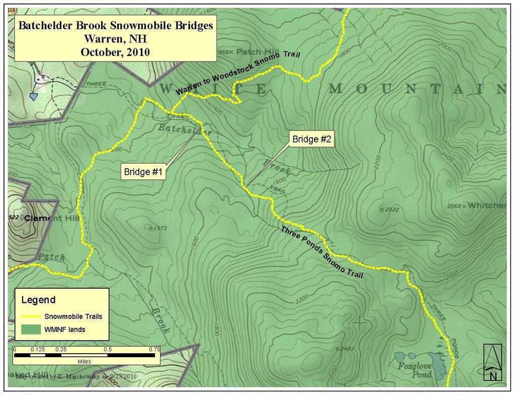
5 1 Summary 2 Background After careful consideration of public input, the recommendations of appropriate resource specialists, and the requirements of applicable laws and regulations, I have decided to authorize construction of three snowmobile bridges. Two will span Batchelder Brook in Warren, NH and the third will span a drainage across the Guinea Pond Trail in Sandwich, NH. 2.1a Project Area- Batchelder Brook The Batchelder Brook proposed bridge sites are along the Batchelder Brook Snowmobile Trail, as identified in the White Mountain National Forest snowmobile system map. The Batchelder brook Snowmobile Trail is 3.6 miles long, running from the Forest boundary in Warren to its intersection with the Three Ponds Snowmobile Trail, forming a connection between Ellsworth, Rumney, and Campton and the Warren to Woodstock Snowmobile Trail. It is an important link between Snowmobile Corridor Trails 5 and 11, the two primary north-south snowmobile trails in Grafton County and in east-central New Hampshire. This segment of trail is groomed regularly and maintained by the Bruhawachet Sno- Trackers, Inc. snowmobile club out of Rumney, NH. The section of trail in question is locally referred to as part of the Three Ponds Snowmobile trail. Batchelder Brook winds down slope to eventually join the Baker River, while the trail proceeds more directly on an old road, crossing Batchelder Brook twice. The lower proposed bridge is 0.3 miles southeast of the three-way junction with this section of Batchelder Brook Snowmobile Trail, Forest Road 401 out of Moosehillock campground, and NH State Primary Snowmobile Trail 153, also known as the Warren to Woodstock snowmobile trail. The upper proposed bridge is 0.4 miles above the first, or 0.7 miles southeast of the aforementioned three-way junction, at the edge of a large clear-cut. While currently the trail at this upper portion crosses two forks of a brief division of the brook, relocating the crossing 100 upstream was deemed preferable by Forest specialists to enable a single span crossing. 5
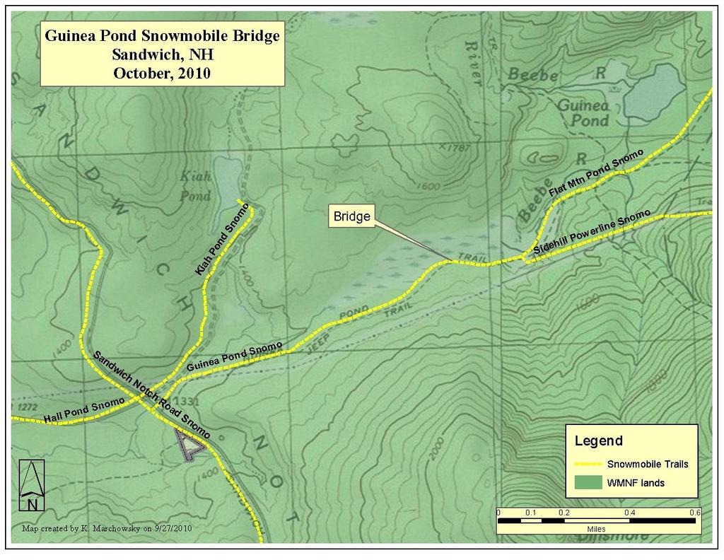
6 2.1b Project Area- Guinea Pond The proposed Guinea Pond snowmobile bridge is located on the Guinea Pond Snowmobile Trail as identified by the White Mountain National Forest snowmobile system map. The trail at this point is on the same footprint as the Guinea Pond hiking trail. The Guinea Pond Snowmobile Trail is 1.3 miles long, running north from the eastern end of Sandwich Notch Road to connect at a three way intersection with the Flat Mountain Pond and the Sidehill Powerline Snowmobile Trails. The project area is located within a tenth of a mile of this intersection. The Flat Mountain Pond Trail affords a less developed, more adventurous motorized winter experience out to its terminus at the Flat Mountain Pond shelter, while the Sidehill Powerline connection provides a loop back to the Sandwich area off the popular Sandwich Notch Road. Generally the area offers a more remote backcountry experience, and is groomed and maintained by the Sandwich Sidehillers Winter Trail Club. 2.2 Purpose and Need- Batchelder Brook and Guinea Pond Snowmobiling is an important component of winter recreation and tourism in New Hampshire. Local snowmobile clubs work hard to maintain trails, applying for grants and matching funds to keep their local trail systems well constructed, drained, and stable. It is part of the WMNF goals and objectives to provide winter motorized recreation opportunities on NFS lands in areas designated appropriate for such use. These trails are an important component for the statewide snowmobile trail system, and are located in Management Area 2.1, General Forest Management, which is suitable for winter motorized recreation. The first or most southerly existing Batchelder Brook crossing is a rocky ford across the brook. Banks have eroded and the stream is overwidened in the crossing area, relative to the undisturbed reach up and downstream. While Forest specialists have not indicated that there is a resource need to repair this area, a bridge would allow the banks to naturalize over time. The existing ford does not reliably freeze to allow for safe snowmobile passage for much of the season. The second crossing of Batchelder Brook involves a 300 foot relocation through a clear cut. Specialists felt that the added disturbance was a worthy trade off for a more stable crossing area. Currently the crossing is at a spot where the brook di- 6
7 vides briefly, and the original proposal was for two smaller bridges. A pair of bridges here would be a more risky investment than the single larger bridge downstream because of the relative likelihood of unpredictable changes to the current flow in the divided area. Additionally the banks are higher and better suited for a bridge at the downstream spot than where snowmobiles currently cross. Batchelder Brook can open early in the spring, and in some seasons the crossings never freeze adequately to provide a safe crossing for snowmobiles. The absence of a bridge here can prevent snowmobilers from connection with many popular routes and limits access to the State trail system in Lincoln and Woodstock and points north. The Guinea Pond proposal was submitted by the Sandwich Sidehillers Winter Trail Club with encouragement from the Forest Service due to a safety concern. The project entails construction of a small bridge over a low-lying area on the railroad grade that drains water between two marshes. While the cross-drain is shallow, it regularly fails to ice bridge and creates a hazardous void in the trail. As a dual use trail the bridge would also improve the hiking trail and protect against resource damage as currently hikers frequently trample trailside vegetation or throw debris into the drainage in an attempt to keep their feet dry. 2.3 Alternative Actions Considered But Dismissed As the Batchelder Brook trail necessitates the crossing of the same brook twice I considered relocating this trail to keep it on one side of the brook, thereby eliminating the crossings. Specialists noted and I agree that the impacts of such an action would be considerably greater than the installation of the two bridges. The current footprint of the trail is stable and well-drained, and the meandering nature of Batchelder Brook would require a relocation that is considerably longer than the current trail. There were various possible locations for the Batchelder Brook crossings that were carefully vetted by Forest Specialists as well as recreation and timber staff, and I am confident that the best location for all considerations was selected. There are limited options at the Guinea Pond site besides the no action alternative, as the area is a marsh on either side of the trail. The maintaining club has in the past placed pallets in the drainage after the first snowfall to mitigate safety 7
8 hazards, but the removal of temporary bridging can be very difficult to time, and result in clogging of the drainage or pallets lost in the marsh. I dismissed a no action alternative on the described projects because it does not address the purpose and need erosion due to the existing fords and a compelling safety concern on system snowmobile trails. 3 Decision to Be Implemented My decision is to authorize the Bruhawachet Snowmobile Club to construct a 42- foot bridge and upstream a 36-foot bridge across Batchelder Brook along the Batchelder Brook Snowmobile Trail in Warren, NH. The bridges will be constructed to Forest Service standards, will be 12 feet wide, and will support snowmobile grooming equipment. The proposal is consistent with the WMNF Land and Resource Management Plan s (Forest Plan) goals, objectives, standards and guidelines. Construction of these bridges is not expected to change the amount or nature of use these trails currently receive. Implementation is expected to occur during fall of 2010, when soil conditions are favorable for all soil disturbing activities. It is expected that this project would be completed prior to late fall, The responsible clubs or their contractors will complete the work. This decision is based on my review of the project record, including input from the public and appropriate resource specialists. The record shows a thorough review of relevant scientific information, a consideration of responsible opposing views, and the acknowledgement of incomplete or unavailable information, scientific uncertainty, and risk. My decision is also based on my past experiences with similar activities on the White Mountain National Forest. 4 Rationale for Categorically Excluding the Decision Based on information in the project record and experience with similar activities on the WMNF, I have concluded that this decision can be categorically excluded from documentation in an environmental impact statement or environmental assessment. Decisions may be categorically excluded from documentation in an environmen- 8
9 tal impact statement or an environmental assessment when they are within one of the categories found at 36 CFR 220.6(d) and (e), and there are no extraordinary circumstances related to the decision. 4.1 Category of Exclusion I have determined that the selected action is a routine activity within the following category of exclusion found at 36 CFR 220.6(e)(1): Construction and reconstruction of trails. 4.2 Findings that No Extraordinary Circumstances Exist Based on information presented in this document and the entirety of the project record, I have evaluated the resource conditions listed in 36 CFR 220.6(b)(1) and determined there are no extraordinary circumstances related to this project. As indicated in 36 CFR 220.6(b)(2), the mere presence of one or more of the listed resource conditions does not preclude use of a categorical exclusion. It is the degree of the potential effects of a proposed action on these resource conditions that determines whether extraordinary circumstances exist. As long as the potential effects on these resources are minor or non-existent, there are no extraordinary circumstances (Forest Service Handbook , Chapter 30.4). A summary of the project s potential effects on each resource condition follows. Federally listed threatened or endangered species or designated critical habitat, species proposed for Federal listing or proposed critical habitat, or Forest Service sensitive species. The Endangered Species Act requires that federal activities not jeopardize the continued existence of any species federally listed or proposed as threatened or endangered, or result in adverse modification to such species designated critical habitat. As required by this Act, potential effects of this decision on listed species have been analyzed and documented in a Biological Evaluation (project record). As detailed in the Biological Evaluation (BE), this decision will have no effect on listed species or designated critical habitats because no listed species or critical habitats have the potential to occur in the area that would be affected by this project. As discussed in the BE, Canada lynx is not considered to be present on the WMNF south of Route 2, and there is no critical habitat for this species on the Forest. Potential effects of this decision on Regional Forester sensitive species (sensitive species) also have been analyzed and documented in a BE (project record). Based 9
10 on known occurrence records and habitat conditions, one sensitive species, the Eastern small-footed myotis, has very low potential to occur in the area that would be affected by this project. For the reasons indicated in the Biological Evaluation, the project would have no impact on this species. This project also would have no impact on any other sensitive species because they do not occur in the project area. Floodplains, Wetlands, or Municipal Watersheds Executive Orders and direct federal agencies to avoid adverse impacts to floodplains or wetlands, which are defined in the executive orders. This project will improve the condition of the associated watershed by replacing a ford currently traversed by snowmobiles, ATV s and groomer with a bridge spanning bankfull width. All necessary wetlands permits will be granted prior to project implementation. Congressionally designated areas, such as wilderness, wilderness study areas, or national recreation areas The project area is not within any congressionally designated areas. The nearest congressionally designated area is the Pemigewasset Wilderness. Impacts from this project would be limited to the immediate area of activity and will not affect any congressionally designated areas. Inventoried roadless area (IRA) or potential wilderness area This project is not within any Roadless Area Conservation Rule (RACR, 2001) inventoried roadless or potential wilderness areas nor will it have any effect on these areas. Both bridges across Batchelder Brook are in the South Carr Mountain IRA identified in 2005 WMNF Forest Plan revision. None of this IRA was recommended for wilderness consideration during Forest Plan revision. While construction of these bridges will have minor effects on roadless inventory criteria (noise during construction and the addition of small bridges), they would not affect the eligibility of this area for future roadless inventories (see project file). Research Natural Areas There are no Research Natural Areas in or near the project area. This decision, with impacts limited to the immediate area of activity, will not affect Research Natural Areas. 10
11 American Indian and Alaska Native religious or cultural sites; and archaeological sites, and historic properties or areas 5 Public Involvement This decision complies with the National Historic Preservation Act, the Archaeological Resources Protection Act, and the Native American Graves Protection and Repatriation Act. The Forest Archaeologist reviewed the project site and historic records for the area and determined that this project has no potential to affect historic properties (see project file). As described previously, these projects were proposed by the Bruhawachet and Sandwich Sidehillers Snowmobile Clubs. The clubs have applied for grant monies from the State of NH to purchase materials for the bridges. Pemigewasset District staff and Forest Specialists have discussed the proposals carefully and visited the site. Limited scoping of known interested members of the public took place and no objections have been raised. This project was listed in the Schedule of Proposed Actions beginning October Findings Required By and/or Related to Other Laws and Regulations My decision will comply with all applicable laws and regulations. I have summarized some pertinent ones below. National Environmental Policy Act This Act requires public involvement and consideration of potential environmental effects. The entirety of documentation for this decision supports compliance with this Act. Forest Plan Consistency (National Forest Management Act) The National Forest Management Act (NFMA) requires that all site-specific project activities be consistent with direction in the applicable Land and Resource Management Plan (Forest Plan). This project implements the WMNF Forest Plan. As required by NFMA Section 1604(i), I find this project to be consistent with the WMNF Forest Plan including goals, objectives, desired future conditions, and Forest-wide and Management Area standards and guidelines. 11
12 7 Administrative Review or Appeal This type of activity is not covered by the 2005 Earth Island Institute v. Ruthenbeck court ruling. Therefore this decision is not subject to appeal in accordance with 36 CFR Implementation Date and Contact Implementation of this decision may begin immediately. For additional information concerning this decision, contact: Jenny Burnett at jburnett@fs.fed.us, or by phone ( ), or by FAX ( ). Additional information about this decision also can be found on the White Mountain National Forest web page at: < /s/ Molly Fuller October 14, 2010 MOLLY FULLER Date Pemigewasset District Ranger Responsible Official 12
White Mountain National Forest
 White Mountain National Forest United States Department of Agriculture Forest Service Eastern Region Boles Brook Snowmobile Bridge Decision Memo Boles Brook Snowmobile Bridge Project Town of Woodstock
Decision Memo for Desolation Trail: Mill D to Desolation Lake Trail Relocation
 for Salt Lake County, Utah Uinta-Wasatch-Cache National Forest Salt Lake Ranger District 1. Background The present location of the Desolation Trail (#1159) between Mill D and Desolation Lake follows old
DECISION MEMO. Rawhide Trail #7073 Maintenance and Reconstruction
 Page 1 of 6 Background DECISION MEMO USDA Forest Service Jefferson Ranger District Jefferson County, Montana Rawhide Trail #7073 is located in the Elkhorn Mountain Range approximately 10 miles east of
White Mountain National Forest Saco Ranger District
 United States Department of Agriculture Forest Service White Mountain National Forest 33 Kancamagus Highway Conway, NH 03818 Comm: (603) 447-5448 TTY: (603) 447-3121 File Code: 1950 Date: February 26,
Decision Memo Ice Age Trail Improvement (CRAC 37)
") Decision Memo Ice Age Trail Improvement (CRAC 37) U.S. Forest Service Chequamegon-Nicolet National Forest, Medford-Park Falls Ranger District Taylor County, Wisconsin T32N, R2W, Town of Grover, Section
Decision Memo Ice Age Trail Improvement (CRAC 37) U.S. Forest Service Chequamegon-Nicolet National Forest, Medford-Park Falls Ranger District Taylor County, Wisconsin T32N, R2W, Town of Grover, Section
Bradley Brook Relocation Project. Scoping Notice. Saco Ranger District. United States Department of Agriculture Forest Service
 Bradley Brook Relocation Project United States Department of Agriculture Forest Service Scoping Notice White Mountain National Forest February 2011 For Information Contact: Jenny Burnett White Mountain
Decision Memo Sun Valley Super Enduro & Cross-Country Mountain Bike Race. Recreation Event
 Decision Memo 2015 Sun Valley Super Enduro & Cross-Country Mountain Bike Race Recreation Event USDA Forest Service Ketchum Ranger District, Sawtooth National Forest Blaine County, Idaho Background The
BACKGROUND DECISION. Decision Memo Page 1 of 6
 DECISION MEMO DEVIL S ELBOW BY-PASS, BOUNDARY TRAIL NO.1 U.S. FOREST SERVICE T9N, R7E, SECTION 9 RANGE 5E COWLITZ COUNTY WA MOUNT ST. HELENS NATIONAL VOLCANIC MONUMENT, GIFFORD PINCHOT NATIONAL FOREST
Decision Memo Broken Wheel Ranch Equestrian Outfitter Special-Use Permit Proposed Action
 Decision Memo Broken Wheel Ranch Equestrian Outfitter Special-Use Permit USDA Forest Service Mississippi Bluffs Ranger District, Shawnee National Forest Jackson and Union Counties, Illinois Proposed Action
DECISION MEMO For Bullis Hollow Trail
 I. DECISION TO BE IMPLEMENTED A. Description of Decision DECISION MEMO For Bullis Hollow Trail USDA Forest Service, Eastern Region 9 Allegheny National Forest Bradford Ranger District Corydon Township
White Mountain National Forest. Pond of Safety Accessible Trail & Shoreline Access Project. Scoping Report. Township of Randolph Coos County, NH
 White Mountain National Forest United States Department of Agriculture Forest Service Eastern Region Pond of Safety Accessible Trail & Shoreline Access Project Township of Randolph Coos County, NH Scoping
White Mountain National Forest. Rumney Rocks Project Supplemental Environmental Assessment. 30-day Comment Report
 White Mountain National Forest United States Department of Agriculture Forest Service Rumney Rocks Project Supplemental Environmental Assessment Eastern Region Town of Rumney, Grafton County, NH 30-day
DECISION MEMO Whetstone Ridge Trail #8020 Relocation
 Page 1 of 7 Background DECISION MEMO Whetstone Ridge Trail #8020 Relocation USDA Forest Service Pintler Ranger District Granite County T4N, R16W, Sections 4,9,29 and T4N, R17W, Section 36 Whetstone Ridge
DECISION MEMO North Zone (Legacy Trails) Trail Stabilization Project
 Trail Stabilization Project") DECISION MEMO North Zone (Legacy Trails) Trail Stabilization Project USDA FOREST SERVICE Rocky Mountain Region (R2) Shoshone National Forest Wapiti and Greybull Ranger District Park County, Wyoming Background
DECISION MEMO North Zone (Legacy Trails) Trail Stabilization Project USDA FOREST SERVICE Rocky Mountain Region (R2) Shoshone National Forest Wapiti and Greybull Ranger District Park County, Wyoming Background
Proposed Action. Payette National Forest Over-Snow Grooming in Valley, Adams and Idaho Counties. United States Department of Agriculture
 United States Department of Agriculture Forest Service January 2012 Proposed Action Payette National Forest Over-Snow Grooming in Valley, Adams and Idaho Counties Payette National Forest Valley, Adams
Decision Memo for Philmont Scout Ranch Bike Trail and Access Reroute Project
 Decision Memo Philmont Scout Ranch Bike Trail and Access Reroute Project USDA Forest Service, Southwestern Region Questa Ranger District, Carson National Forest Colfax County, New Mexico (T. 30N, R. 17E,
White Mountain National Forest Saco Ranger District
 United States Department of Agriculture Forest Service White Mountain National Forest Saco Ranger District 33 Kancamagus Highway Conway, NH 03818 Comm: (603) 447-5448 TTY: (603) 447-3121 File Code: 1950
Hiawatha National Forest St. Ignace Ranger District. File Code: 1950 Date: August 5, 2011
 United States Department of Agriculture Forest Service Hiawatha National Forest St. Ignace Ranger District W1900 West US-2 St. Ignace, MI 49781 906-643-7900 File Code: 1950 Date: August 5, 2011 Dear National
Daisy Dean Trail 628/619 ATV Trail Construction
 Background and Purpose and Need The Daisy Dean ATV Trail Construction Project is located in the Little Belt Mountains, Musselshell Ranger District, Lewis and Clark National Forest approximately 32 miles
Rochester Ranger District Wellness Trails Project
 United States Department of Agriculture Forest Service Eastern Region September 2015 Rochester Ranger District Wellness Trails Project Decision Memo Green Mountain National Forest Rochester Ranger District
White Mountain National Forest. Campton Day Use Area Development Project. Scoping Report. Prepared by the Pemigewasset Ranger District May 2013
 White Mountain National Forest Campton Day Use Area Development Project United States Department of Agriculture Forest Service Eastern Region Towns of Thornton and Campton, Grafton County, NH Scoping Report
Tracy Ridge Shared Use Trails and Plan Amendment Project
 Tracy Ridge Shared Use Trails and Plan Amendment Project Scoping Document Forest Service Allegheny National Forest Bradford Ranger District McKean, County, Pennsylvania In accordance with Federal civil
DECISION MEMO Grand Targhee Resort Summer Trails. USDA Forest Service Caribou-Targhee National Forest Idaho Falls, Idaho 83401
 DECISION MEMO Grand Targhee Resort Summer Trails USDA Forest Service Caribou-Targhee National Forest Idaho Falls, Idaho 83401 Background Situated on the east side of the Teton Mountain Range, Grand Targhee
White Mountain National Forest
 White Mountain National Forest United States Department of Agriculture Forest Service Eastern Region Greeley Ponds and Flume Brook Trail Repair Project Waterville Valley, Grafton County, NH Decision Notice
Buford / New Castle Motorized Trail
 Buford / New Castle Motorized Trail Rifle Ranger District, White River National Forest Garfield County, Colorado Comments Welcome The Rifle Ranger District of the White River National Forest welcomes your
Sawtooth National Forest Fairfield Ranger District
 United States Department of Agriculture Forest Service Sawtooth National Forest Fairfield Ranger District P.O. Box 189 Fairfield, ID. 83327 208-764-3202 Fax: 208-764-3211 File Code: 1950/7700 Date: December
Buffalo Pass Trails Project
 Buffalo Pass Trails Project Hahns Peak/Bears Ears Ranger District, Medicine Bow-Routt National Forests and Thunder Basin National Grassland Routt County, Colorado T6N 83W Sections 3-5, 8; T6N 84W Sections
GREENWOOD VEGETATION MANAGEMENT
 APPENDIX G GREENWOOD VEGETATION MANAGEMENT PROJECT RECREATION RESOURCE REPORT Prepared by: Laurie A. Smith Supervisory Forester Stearns Ranger District Daniel Boone National Forest August 4, 2016 The
Eagle Rock Loop Ouachita National Forest Page 1 of 8
 EAGLE ROCK LOOP Eagle Rock Loop Ouachita National Forest Page 1 of 8 Hiking: Biking: Equestrian: Trail Highlights: This trail offers the longest loop trail in Arkansas. A combination of the Little Missouri,
Crystal Lake Area Trails
 Lake Area Trails Welcome to the Lake area of the Big Snowy Mountains! This island mountain range in central Montana features peaks reaching to 8,600 feet and long, high ridges from which vistas of the
RIM TRAIL EXTENSION PROJECT
 DECISION MEMO For RAINBOW RIM TRAIL EXTENSION PROJECT Located on National Forest System Lands USDA Forest Service, Southwest Region Kaibab National Forest - North Kaibab Ranger District T.35 N, R.1 E,
Project Planning, Compliance, and Funding
 Project Planning, Compliance, and Funding The plans above offer high level guidance to ensure that the A.T. is managed effectively as a whole unit in a decentralized management structure. Cooperative management
White Mountain National Forest Androscoggin and Evans Notch Ranger Districts
 United States Department of Agriculture Forest Service White Mountain National Forest Androscoggin and Evans Notch Ranger Districts 300 Glen Road Gorham, NH 03581-1399 Comm: (603) 466-2713 TTD: (603) 466-2856
Tahoe National Forest Over-Snow Vehicle Use Designation
 Tahoe National Forest Over-Snow Vehicle Use Designation USDA Forest Service Tahoe National Forest February 20, 2015 Introduction The Forest Service, U.S. Department of Agriculture will prepare an Environmental
DECISION MEMO. for Single-Track Mountain Bike Trail Snowbird Ski and Summer Resort
 DECISION MEMO for Single-Track Mountain Bike Trail Snowbird Ski and Summer Resort Salt Lake County, Utah Uinta-Wasatch-Cache National Forest Salt Lake Ranger District DECISION AND RATIONALE I have reviewed
Planning Grazing. Pasture Planning. Fencing for Grazing Systems. High Tensile. High Tensile. High Tensile 3/31/2014. water, and paddocks
 Planning Grazing Systemsfencing, water, and paddocks Dan Ludwig NRCS Grazing Specialist- SE PA Natural Resources Conservation Service Berks County Grazing School Fencing Perimeter Paddock Alleyway Water
BACKCOUNTRY TRAIL FLOOD REHABILITATION PROGRAM
 BACKCOUNTRY TRAIL FLOOD REHABILITATION PROGRAM Backcountry Trail Flood Rehabilitation A June 2013 Flood Recovery Program Summary In June 2013, parts of Southern Alberta were devastated from significant
Description of the Proposed Action for the Big Creek / Yellow Pine Travel Plan (Snow-free Season) and Big Creek Ford Project
 and Big Creek Ford Project") Description of the Proposed Action for the Big Creek / Yellow Pine Travel Plan (Snow-free Season) and Big Creek Ford Project Payette National Forest Krassel Ranger District Valley and Idaho Counties, Idaho
Description of the Proposed Action for the Big Creek / Yellow Pine Travel Plan (Snow-free Season) and Big Creek Ford Project Payette National Forest Krassel Ranger District Valley and Idaho Counties, Idaho
Alternative 3 Prohibit Road Construction, Reconstruction, and Timber Harvest Except for Stewardship Purposes B Within Inventoried Roadless Areas
 Roadless Area Conservation FEIS Summary Table S-1. Comparison of Key Characteristics and Effects by Prohibition Alternative. The effects summarized in this table A would occur in inventoried roadless areas
Chetco River Kayaking Permit
 Decision Memo USDA Forest Service Rogue River-Siskiyou National Forest Gold Beach Ranger District - Curry County, Oregon Wild Rivers Ranger District Josephine County, Oregon BACKGROUND A special use permit
Chattahoochee- Oconee National Forests. Decision Memo
 Page 1 of 6 USDA Forest Service Chattahoochee- Oconee National Forests Decision Memo Chattahoochee-Oconee National Forests Home Page Recreation Information Forest History Forest Facts Forest Management
CHAPTER III: TRAIL DESIGN STANDARDS, SPECIFICATIONS & PERMITS
 CHAPTER III Trail Design Standards, Specifications & Permits This chapter discusses trail standards, preferred surface types for different activities, permits, and other requirements one must consider
Ottawa National Forest Supervisor s Office
 United States Department of Agriculture Forest Service Supervisor s Office E6248 US2 Ironwood, MI 49938 (906) 932-1330 (906) 932-0122 (FAX) File Code: 1950/2350 Date: April 11, 2012 Dear Friends of the,
White Mountain National Forest Androscoggin and Evans Notch Ranger Districts
 United States Department of Agriculture Forest Service White Mountain National Forest Androscoggin and Evans Notch Ranger Districts 300 Glen Road Gorham, NH 03581-1399 Comm: (603) 466-2713 TTD: (603) 466-2856
Resolution Shelter Removal and Site Plan Sargents Purchase Coos County, New Hampshire
 United States Department of Agriculture Forest Service April 2011 Resolution Shelter Removal and Site Plan Sargents Purchase Coos County, New Hampshire Scoping Report Prepared By Saco Ranger District,
Memo. Board of County Commissioners. FROM: Tamra Allen, Planner. Buford/New Castle Motorized Trail. Date: February 13, 2012
 Memo TO: Board of County Commissioners FROM: Tamra Allen, Planner RE: Buford/New Castle Motorized Trail Date: February 13, 2012 Overview The White River National Forest Rifle District Office ( RDO ) issued
Stagecoach State Trail Master Plan
 Stagecoach State Trail Master Plan Minnesota Minnesota Department Department of of Natural Natural Resources Resources Parks and and Trails Trails Division Division Parks March March 2012 2012 The Minnesota
Chetco River Kayaking Permit
 Preliminary Decision Memo USDA Forest Service Rogue River-Siskiyou National Forest Gold Beach Ranger District - Curry County, Oregon BACKGROUND A special use permit has been requested by Zachary Collier,
DESIGN FEATURES ASSOCIATED WITH THE SELECTED ALTERNATIVE
 -:::-= D DECISION NOTICE /FINDING OF No SIGNIFICANT IMPACT BRUNDAGE MOUNTAIN CAT-SKI OUTFITTER AND GUIDE PERMIT BOUNDARY EXPANSION U.S. FOREST SERVICE PAYETTE NATIONAL FOREST NEW MEADOWS RANGER DISTRICT
Cascade River State Park Management Plan Amendment
 This document is made available electronically by the Minnesota Legislative Reference Library as part of an ongoing digital archiving project. http://www.leg.state.mn.us/lrl/lrl.asp Cascade River State
Rule Governing the Designation and Establishment of All-Terrain Vehicle Use Trails on State Land
 Rule Governing the Designation and Establishment of All-Terrain Vehicle Use Trails on State Land 1.0 Authority 1.1 This rule is promulgated pursuant to 23 V.S.A. 3506. Section 3506 (b)(4) states that an
FS-14 Parachute. Packing Instructions. United States Department of Agriculture. Forest Service. Technology & Development Program
 United States Department of Agriculture Forest Service Technology & Development Program 5700 Aviation June 1998 9857-2817-MTDC Revised June 1998 Packing Instructions FS-14 Parachute Pat Wilson Project
ROAD AND TRAIL PROJECT APPROVAL
 ROAD AND TRAIL PROJECT APPROVAL www.marincountyparks.org Marin County Parks, 3501 Civic Center Dr, Suite 260, San Rafael, CA 94903 DATE: July 12, 2017 PRESERVE: Gary Giacomini Open Space Preserve PROJECT:
DECISION NOTICE FINDING OF NO SIGNIFICANT IMPACT US FOREST SERVICE TONGASS NATIONAL FOREST JUNEAU RANGER DISTRICT
 DECISION NOTICE FINDING OF NO SIGNIFICANT IMPACT US FOREST SERVICE TONGASS NATIONAL FOREST JUNEAU RANGER DISTRICT Trail of Time Adjacent Area Trails and Mendenhall Glacier Visitor Center Improvements Project
April 10, Mark Stiles San Juan Public Lands Center Manager 15 Burnett Court Durango, CO Dear Mark,
 Mark Stiles San Juan Public Lands Center Manager 15 Burnett Court Durango, CO 81301 Dear Mark, We are pleased to offer the following comments on the draft San Juan Public Lands Center management plans
USDA Forest Service Deschutes National Forest DECISION MEMO. Round Lake Christian Camp Master Plan for Reconstruction and New Facilities
 USDA Forest Service Deschutes National Forest DECISION MEMO Round Lake Christian Camp Master Plan for Reconstruction and New Facilities Jefferson County, Oregon T. 13 S., R. 8 E., Section 16, W.M. Background:
Appendix A Appendix A (Project Specifications) Auk Auk / Black Diamond (Trail 44) Reroute
 Auk Auk / Black Diamond (Trail 44) Reroute") Appendix A (Project Specifications) Auk Auk / Black Diamond (Trail 44) Reroute I. Proposed Action: This project proposes to reroute approximately 1,800 feet of a 50 inch wide trail, off of private property
Appendix A (Project Specifications) Auk Auk / Black Diamond (Trail 44) Reroute I. Proposed Action: This project proposes to reroute approximately 1,800 feet of a 50 inch wide trail, off of private property
Wallowa Falls Hydroelectric Project FERC Project No. P-308 Proposed Study Plans - Recreation August 2011
 Wallowa Falls Hydroelectric Project FERC Project No. P-308 August 2011 Prepared by: PacifiCorp Energy Hydro Resources 825 NE Multnomah, Suite 1500 Portland, OR 97232 For Public Review Wallowa Falls Hydroelectric
WORKSHEET 1 Wilderness Qualities or Attributes Evaluating the Effects of Project Activities on Wilderness Attributes
 WORKSHEET 1 Wilderness Qualities or Attributes Evaluating the Effects of Project Activities on Wilderness Attributes Date: 3/7/2017 Roadless Area: Ruby South Description of Project Activity or Impact to
Continental Divide National Scenic Trail Legislative History and Planning Guidance
 Continental Divide National Scenic Trail Legislative History and Planning Guidance Legislation, Policy, and Direction Regarding National Scenic Trails The National Trails System Act, P.L. 90-543, was passed
Wilderness Specialist s Report
 United States Department of Agriculture Forest Service July 2009 Wilderness Specialist s Report Travel Management Rule EIS USDA Forest Service Southwestern Region Apache-Sitgreaves National Forests Prepared
TONGASS NATIONAL FOREST
 TONGASS NATIONAL FOREST UNITED STATES DEPARTMENT OF AGRICULTURE-FOREST SERVICE Contact: Dennis Neill Phone: 907-228-6201 Release Date: May 17, 2002 SEIS Questions and Answers Q. Why did you prepare this
Public Notice ISSUED: December 10, 2018 EXPIRES: January 9, 2019
 APPLICANT: REFER TO: St. Louis and Lake Counties Regional Rail Authority 2018-01942-ARC Public Notice ISSUED: December 10, 2018 EXPIRES: January 9, 2019 SECTION:404 - Clean Water Act 1. APPLICATION FOR
APPENDIX D: SUSTAINABLE TRAIL DESIGN. APPENDICES Town of Chili Parks and Recreation Master Plan Update
 APPENDIX D: SUSTAINABLE TRAIL DESIGN APPENDICES Town of Chili Parks and Recreation Master Plan Update Sustainable Trail Construction Sustainable trails are defined by the US Forest Service as trails having
Bear Creek Habitat Improvement Project
 06/10/10 Bear Creek Habitat Improvement Project El Paso County, Colorado Pike National Forest and Colorado Springs Utilities Owned Land Report prepared by: Eric Billmeyer Executive Director Rocky Mountain
Yard Creek Provincial Park. Management Plan
 Yard Creek Provincial Park Management Plan Draft January 2010 Yard Creek Provincial Park Management Plan Approved by: telàlsemkin/siyam/chief Scott Benton Bill Williams Squamish Executive Director ation
USDA FOREST SERVICE, HIAWATHA NATIONAL FOREST Alger County, Michigan. Grand Island Primitive Cabins Project
 USDA FOREST SERVICE, HIAWATHA NATIONAL FOREST Alger County, Michigan I. INTRODUCTION Grand Island Primitive Cabins Project DECISION NOTICE and FINDING OF NO SIGNIFICANT IMPACT This document describes my
DRAFT. Dorabelle Campground Rehabilitation
 DRAFT Dorabelle Campground Rehabilitation September 2012 1.1 REGIONAL SETTING AND PROJECT LOCATION The Dorabelle Campground is located on the western shore of Shaver Lake in Fresno County, California (Section
City of Durango 5.8 FUNDING TRAILS DEVELOPMENT
 5.8 FUNDING TRAILS DEVELOPMENT The City has been successful in establishing dedicated local funding sources as well as applying for grants to develop the City s trail system, having received nearly $2.4
Draft Decision Notice and Finding of No Significant Impact
 United States Department of Agriculture Draft Decision Notice and Finding of No Significant Impact Zuni Mountain Trail Project Cibola National Forest, Mt Taylor Ranger District McKinley County & Cibola
National Forests and Grasslands in Texas
 United States Department of Agriculture Forest Service National Forests and Grasslands in Texas Sam Houston NF 394 FM 1375 West New Waverly, Texas 77358 Phone 936-344-6205 Dear Friends, File Code: 1950
White Mountain National Forest. Scoping Report. Presidential Range-Dry River Wilderness Area Trails Project. Saco Ranger District January 2014
 White Mountain National Forest United States Department of Agriculture Forest Service Eastern Region Presidential Range-Dry River Wilderness Area Trails Project Townships of Cutts Grant and Sargents Purchase,
Dodge Ridge Mountain Bike Trails (50375) Decision Memo
 Decision Memo") Dodge Ridge Mountain Bike Trails (5375) Decision Memo Stanislaus National Forest Summ Ranger District Tuolumne County, CA This decision memo provides documentation, pursuant to the National Environmental
Dodge Ridge Mountain Bike Trails (5375) Decision Memo Stanislaus National Forest Summ Ranger District Tuolumne County, CA This decision memo provides documentation, pursuant to the National Environmental
Flow Stand Up Paddle Board Parkway Plan Analysis
 Regional Parks Department Jeffrey R. Leatherman, Director County of Sacramento Divisions Administration Golf Leisure Services Maintenance Rangers Therapeutic Recreation Services Flow Stand Up Paddle Board
DRAFT - APRIL 13, 2007 ROUTING STUDY FOR TRAIL CONNECTIONS BETWEEN CALAIS AND AYERS JUNCTION
 DRAFT - APRIL 13, 2007 ROUTING STUDY FOR TRAIL CONNECTIONS BETWEEN CALAIS AND AYERS JUNCTION Abstract The vision for the East Coast Greenway is an off-road urban trail system running from Calais, Maine
Decision Notice and Finding of No Significant Impact
 Decision Notice and Finding of No Significant Impact Steamboat Ski Area Summer Trails Project USDA Forest Service Medicine Bow-Routt National Forests Hahns Peak/Bears Ears Ranger District Routt County,
Non-motorized Trail Plan & Proposal. August 8, 2014
 Town of Star Valley Ranch, Wyoming and the Star Valley Ranch Association in partnership with the USDA Forest Service, Bridger-Teton National Forest, Greys River Ranger District Non-motorized Trail Plan
White Mountain National Forest
 White Mountain National Forest United States Department of Agriculture Forest Service Eastern Region Moat Mountain Trail System Project Environmental Assessment Saco Ranger District September 2010 For
Lakes Landscape Travel Management
 Decision Notice & Finding of No Significant Impact Lakes Landscape Travel Management USDA Forest Service Columbine Ranger District, San Juan National Forest Archuleta, Hinsdale, and La Plata Counties,
Wilderness Process #NP-1810: Your letter ID is NP September 5, 2018
 Wilderness Process #NP-1810: Your letter ID is NP-1810-2602-96 September 5, 2018 RE: GMUG Wilderness Evaluation Revised Evaluation Criteria and Draft Report Forest Revision Planning Team: The Continental
Table of Contents. page 3 Long term Goals Project Scope Project History. 4 User Groups Defined Trail Representative Committee. 5 Trail Users Breakdown
 Launched April 27th, 2010 1 Table of Contents page 3 Long term Goals Project Scope Project History 4 User Groups Defined Trail Representative Committee 5 Trail Users Breakdown 13 Trail Users Desires 16
Finn Creek Park. Management Direction Statement Amendment
 Finn Creek Park Management Direction Statement Amendment November 2013 Management Direction Statement Amendment Approved by: Jeff Leahy Regional Director, Thompson Cariboo BC Parks November 12, 2013 Date
Coronado National Forest Santa Catalina Ranger District
 United States Department of Agriculture Forest Service Coronado National Forest Santa Catalina Ranger District File Code: 1950 Date: October 14, 2015 Dear Interested Party: The Santa Catalina Ranger District
Silver Creek Plunge Campground Reconstruction
 Silver Creek Plunge Campground Reconstruction PROPOSED ACTION REPORT Emmett Ranger District Boise National Forest 1805 Highway 16, Room 5 Emmett, Idaho 83617 November 2009 Silver Creek Plunge Campground
Preferred Recreation Recommendations Stemilt-Squilchuck Recreation Plan March 2018
 Preferred Recreation Recommendations Stemilt-Squilchuck Recreation Plan March 2018 Below are the recommended recreation ideas and strategies that package together the various recreation concepts compiled
PROPOSED ACTION South 3000 East Salt Lake City, UT United States Department of Agriculture
 United States Department of Agriculture Forest Service Uinta-Wasatch-Cache National Forest Salt Lake Ranger District 6944 South 3000 East Salt Lake City, UT 84121 801-733-2660 File Code: 1950/2300 Date:
Cuyuna Connection and Cuyuna Hills Backcountry Trail PROPOSED TRAIL DEVELOPMENT December 21, Trail Suitability Analysis
 Cuyuna Connection and Cuyuna Hills Backcountry Trail PROPOSED TRAIL DEVELOPMENT December 21, 2017 Trail Suitability Analysis Trail Suitability Criteria: As set forth in the Crow Wing County Comprehensive
Final Environmental Impact Statement for the Merced Wild and Scenic River. Comprehensive Management Plan, Yosemite National Park, Madera and Mariposa
 This document is scheduled to be published in the Federal Register on 02/26/2014 and available online at http://federalregister.gov/a/2014-04061, and on FDsys.gov DEPARTMENT OF THE INTERIOR 4312-FF NATIONAL
Susitna-Watana Hydroelectric Project (FERC No ) Recreation Resources Study Study Plan Section Study Implementation Report
 Recreation Resources Study Study Plan Section Study Implementation Report") (FERC No. 14241) Recreation Resources Study Study Plan Section 12.5 2014 Study Implementation Report Prepared for Prepared by AECOM November 2015 TABLE OF CONTENTS 1. Introduction... 4 2. Study Objectives...
(FERC No. 14241) Recreation Resources Study Study Plan Section 12.5 2014 Study Implementation Report Prepared for Prepared by AECOM November 2015 TABLE OF CONTENTS 1. Introduction... 4 2. Study Objectives...
Deer Creek. Forest Plan Special Designations and Inventoried Roadless Area Report. Prepared by: Dan Gilfillan North Zone Recreation Staff.
 Forest Plan Special Designations and Inventoried Roadless Area Report Prepared by: Dan Gilfillan North Zone Recreation Staff For: Bonner Ferry Ranger District Idaho Panhandle National Forest 8/28/2015
Hermosa Area Preservation The Colorado Trail Foundation 4/11/2008
 Hermosa Area Preservation The Colorado Trail Foundation 4/11/2008 Legend d o Tr ail NPA - National Protection Area ra NCA - National Conservation Area o e C Th The Colorado Trail lo FS inventoried Roadless
COASTAL CONSERVANCY. Staff Recommendation March 25, 2004 SONOMA COUNTY COASTAL TRAIL, PHASE I. File No Project Manager: Richard Retecki
 COASTAL CONSERVANCY Staff Recommendation March 25, 2004 SONOMA COUNTY COASTAL TRAIL, PHASE I File No. 03-142 Project Manager: Richard Retecki RECOMMENDED ACTION: Authorization to disburse up to $455,000
Montana Wilderness Association v. McAllister, 666 F.3d 549 (9th Cir. 2011). Matt Jennings I. INTRODUCTION
. Matt Jennings I. INTRODUCTION") Montana Wilderness Association v. McAllister, 666 F.3d 549 (9th Cir. 2011). Matt Jennings I. INTRODUCTION In Montana Wilderness Association v. McAllister, 1 the United States Court of Appeals for the Ninth
Montana Wilderness Association v. McAllister, 666 F.3d 549 (9th Cir. 2011). Matt Jennings I. INTRODUCTION In Montana Wilderness Association v. McAllister, 1 the United States Court of Appeals for the Ninth
Roadless Forest Protection
 Roadless Forest Protection On January 12, 2001, after nearly three years of analysis and the greatest public outreach in the history of federal rulemaking, the U.S. Forest Service adopted the Roadless
Understanding user expectations And planning for long term sustainability 1
 Understanding user expectations And planning for long term sustainability 1 What is a natural surface trail? It can be as simple has a mineral soil, mulched or graveled pathway, or as developed as elevated
CHAPTER I. PURPOSE OF AND NEED FOR ACTION
 CHAPTER I. PURPOSE OF AND NEED FOR ACTION DIFFERENCE BETWEEN FEIS AND DEIS A Draft Environmental Impact Statement was prepared by the Lewis and Clark National Forest and released for public comment on
APPENDIX I STANDARD CONSULTATION PROTOCOL FOR TRAVEL MANAGEMENT ROUTE DESIGNATION
 APPENDIX I STANDARD CONSULTATION PROTOCOL FOR TRAVEL MANAGEMENT ROUTE DESIGNATION Developed Pursuant to Stipulation IV.A. of the Region 3 First Amended Programmatic Agreement Regarding Historic Property
3.12 Roadless Areas and Unroaded Areas
 3.12 Roadless Areas and Unroaded Areas Introduction This analysis focuses on the direct and indirect effects of activities proposed in the Como Forest Health project on roadless area values, including
Draft Record of Decision
 United States Department of Agriculture Forest Service September 2014 Draft Record of Decision Oregon Dunes NRA Management Area 10 (C) Designated Routes Project Central Coast Ranger District-Oregon Dunes
S Central Coast Heritage Protection Act APRIL 21, 2016
 STATEMENT OF GLENN CASAMASSA ASSOCIATE DEPUTY CHIEF, NATIONAL FOREST SYSTEM U.S. FOREST SERVICE U.S. DEPARTMENT OF AGRICULTURE BEFORE THE UNITED STATES SENATE COMMITTEE ON ENERGY AND NATURAL RESOURCES