Lenzie. Mapped Heritage. The following maps demonstrate the spatial strategy for the Lenzie trail. Trail themes
|
|
|
- Damian Owen
- 5 years ago
- Views:
Transcription
1
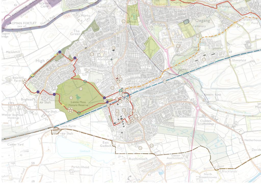
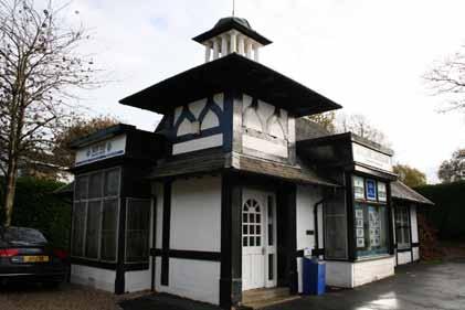
2 Lenzie The following maps demonstrate the spatial strategy for the Lenzie trail. The heritage and proposed trails are presented on two maps per area: Map 2A - Existing heritage locations Map 2B - Existing heritage locations plus proposed trail routes hubs, lures, interpretation, markers, viewpoints. The heritage that has been mapped is the information which has been uncovered by the Trails and Tales team through the life of the project from desk research, site visits and community consultations. It is not an exhaustive list but a snapshot of heritage which has been communicated as important in the life of the area. Through the process of matching locations and heritage stories, many important sites have been noted on the following maps. Only heritage which has a place or site associated with it has been shown in the list and maps, however the project does have repositories of other heritage information for each area which are for now place-less but may inform the production of artistic responses in other ways. We have been as accurate as possible in defining heritage locations but some discrepancies may remain. Mapped Heritage 01. Lenzie railway station 02. Empire exhibition building 03. Ladie s walk (site of) 04. Kenneth McKellar - Victoria Road Machrie Mhor. 05. Bud Neil cartoonist - Victoria Road 06. Greek Thompson House at Victoria Road 07. Grove Park no.12 - wounded soldiers recuperated here 08. Old Schoolhouse and bowling club - Glenbank Road 09. Annan Photographers house - Glenhead / Auchinloch Road 10. Lanarkshire police station at Auchinloch Road 11. Burnbrae Terrace - Jack Gillespie multi-millionaire 12. Cricket club site (now Arnold Clark) - Auchinloch Road 13. Beatrice Clugston - Lenzie Convalescent Home (Lenzie Hospital site at Auchinloch / Crosshill Road). 14. Lenzie Golf Club 15. Garngaber Rd at bridge - Queen s train used to rest here overnight. 16. Woodilee cottages 17. Woodilee Hospital (site of) 18. Spider Bridge (site of) 19. Main row of shops in village centre - various past uses. 20. Old Parish Church 21. Queen s buildings 22. Fern avenue - interesting fence from Lion Foundry 23. Lenzie Primary school (former) 24. Public hall had a debating society 25. Dean House (between Lenzie Union Parish Church and Lenzie Public Hall - Kirkintilloch Road). 26. St. Cyprian s Church 27. Vendanda Laundry at site of Tom Johnstone House 28. Bea Ray (Bea s path) 29. Lenzie Moss (peat cutting) 30. Peat works 31. Weavers stone - Moss Road - was used as a stage / soap box for public readings of the paper & weavers cottages nearby. Trail themes Lenzie s suggested trail theme relates to Merchant s of Glasgow and their villas which have formed the core of the village centre and provide a great deal of interest to the smaller trail loop. The homes or associated buildings of notable characters (Bud Neil, McKellar, Beatrice Clugston) have also proved popular including two references to philanthropic social care and convalescence (Beatrice Clugston s convalescent home and recuperation of wounded veterans at Grove Park). 64
3
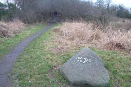
4 Lenzie Trail description Lenzie Moss loop: Starting from Lenzie Railway station car park head towards the end of the north car park parallel to the railway line where signs direct towards Lenzie Moss. The route follows a surfaced path through woodland, following the side of the railway line. Following the path, the route then turns north towards Lenzie Moss Nature reserve and across boardwalks, leaving the woodland behind to emerge into the moss and disused peat workings beyond. The route emerges at Heather Drive and includes a short section through housing. Crossing Boghead Road at the head of Heather Drive, the route continues into Boghead Woodland and passes along the path through the woodland to reach the footpath Christine s Way which follows the course of the Park Burn. The route follows Christine s Way for around 500m until taking a right turn at the path junction back towards Boghead Road. On approaching Boghead Road the trail crosses the road and turns left for 50m to reach a path between housing. Taking a right onto this short path, the trail reaches Oak Drive. At Oak Drive the trail turns right and then second left onto Juniper Court. The trail turns right onto Blackthorn Avenue and immediately left onto Blackthorn Grove where it follows the road round to emerge from the housing into the open ground and return path towards the moss. The trail then follows this northern Moss path back towards the village centre, exiting the moss at Heath Avenue. The trail passes villas on Heath Avenue to emerge at the traffic lights at Kirkintilloch Road where the route turns right to pass the church and the village row of shops before returning to the station car park. right onto Glenhead Road. The context offers views of substantial villas and mature trees in all directions. Following Glenhead Road, the route takes a detour around Grove Park to appreciate the unique setting of this area, with Arts & Crafts villas formed around a central garden. On completing the detour around Grove Park the route returns to Glenhead Road where the junction with Glenbank Road offers views towards the former Schoolhouse and terraced stone villas. The route turns right down a steep incline on Glenhead Road towards Auchinloch Road and turns left onto the main road, continuing along this passing villas such as the Annan House and the old Police Station. The route continues along Auchinloch Road which turns into Kirkintilloch Road as it approaches the railway bridge. The route then follows the road under the bridge and climbs back to the north station car park with views towards the embankment and church tower ahead. This completes the loop back to the railway station. Lenzie Urban Centre loop: If continuing on the figure of eight loop, the trail crosses the pedestrian railway bridge at the station and turns right towards Alexandra Avenue passing the Empire Exhibition building on the left hand side. The route continues along Alexandra Avenue passing a row of village shops and tenements. Alexandra Avenue curves to the left and at this junction the Ladies Mile path offers a detour to Crosshill Road, although overgrown. The route then follows Alexandra Road to the T-junction with Heriot Road, which offers views to the fields to the west. The route turns right at Heriot Road towards Victoria Road where the Greek Thomson Villa can be seen. The route takes a left onto Victoria Road and an immediate 68


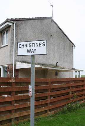
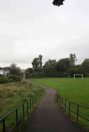
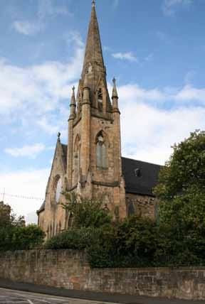
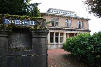
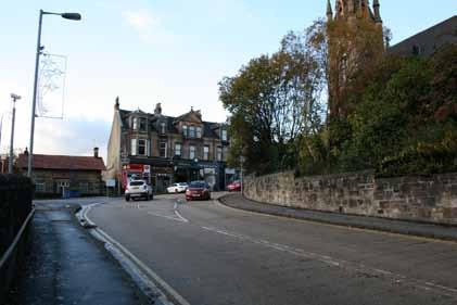
5 Christine s Way Path at Lenzie Station (Bea Ray s path) and village centre Boghead Wood, Empire Exhibition building, Grove Park, Greek Thompson House, Lenzie Moss 69
Torrance. Mapped Heritage. The following maps demonstrate the spatial strategy for the Torrance trails. Trail themes
 Torrance The following maps demonstrate the spatial strategy for the Torrance trails. The heritage and proposed trails are presented on two maps per area: Map 2A - Existing heritage locations Map 2B -
Westerton, Bearsden and Milngavie
 Westerton, Bearsden and Milngavie The following maps demonstrate the spatial strategy for the Westerton, Bearsden and Milngavie trails. The heritage and proposed trails are presented on two maps per area:
The Mendip Way. Route Directions and Maps Uphill to Wells
 The Mendip Way Route Directions and Maps Uphill to Wells Website: www.mendiphillsaonb.org.uk Email: mendip@mendiphillsaonb.org.uk Facebook & Twitter: @MendipHillsAONB Phone: 01761462338 1 Uphill to Loxton
DAVA WAY. Notes on multi-use access
 DAVA WAY Notes on multi-use access The Dava Way is a 24 mile (38km) waymarked long distance route based largely on the dismantled Highland Railway Line between Forres, near the Moray Coast in north-east
ROYAL GORGE PARK and RECREATION AREA. A Feat of Natural and Man-Made Engineering
 ROYAL GORGE PARK and RECREATION AREA A Feat of Natural and Man-Made Engineering As Growth Resumed in the 1870 s Town Leaders Began to Envision a Tourist Industry. The Arkansas River Canyon was advertised
21 Prospect Avenue Cambuslang G72 8BW
 21 Prospect Avenue Cambuslang G72 8BW pacittijones.co.uk Description This is a really impressive and substantial five apartment upper conversion of a detached blonde sandstone villa quietly located within
Places in Brent. Stonebridge. Grange Museum of Community History and Brent Archive
 Places in Brent Stonebridge Grange Museum of Community History and Brent Archive Stonebridge is situated in southern Brent, on the Harrow Road between Harlesden and Wembley. The 17 th and 18 th centuries
BURGHCLERE PARISH RIGHTS OF WAY
 BURGHCLERE PARISH RIGHTS OF WAY Full descriptions compiled by Neill & Miggie Bruce All photos Miggie Bruce FP23 on Ridgemoor, looking south, with FP22 crossing by the bush FP1. From C183 Aldern Bridge
PIONEER PARK. City of Des Peres Parks Master Plan. SWT Design 46 INTRODUCTION
 PIONEER PARK INTRODUCTION Pioneer Park is a 7 acre neighborhood park located east of Interstate 270 and south of Manchester Road along Tallie Road. The park is situated in a residential neighborhood with
DAY 3: Huntleys Point Wharf to Balmain East Wharf
 DAY 3: Huntleys Point Wharf to Balmain East Wharf Total Distance: 14.5km Time: Approximately 5 hours Walk Notes in Five Sections Section Name Length Time 3:1 Huntleys Point Wharf to Iron Cove Bridge 4km
Map: Landranger #27 Forres and Nairn and 36 Grantown and Aviemore
 THE DAVA WAY This is a newly created long distance route that runs from Forres to Grantown, mostly following the old railway line. You will need to detour around a couple of sections that are not really
Bewl Water & the High Weald
 1 Bewl Water & the High Weald Stonegate station - Stonegate - Wallcrouch - Newbarn - Cousley Wood - Wood's Green - Wadhurst station Length: 9 ½ miles (15.3km) Underfoot: Large portions of this path are
Gors Lydan barrows and medieval huts
 Walk Information: Maps: OS Explorer 214 Distance: 5.5 miles / 9 kilometres Duration: 4.5 to 5 hours Difficulty: Easy. Good paths and no steep gradients Start and finish: SO 11977545 Walk summary The walk
Wicklow Mountains Path Survey
 Wicklow Mountains Path Survey Ballinacor Croaghanmoira Fananierin Start to Finish: T 11723 86602 to T 11175 89057 Altitude (lowest highest): 385m 664m Weather: Hot Access: Coolgarrow forest entrance Surveyed
Ivinghoe Beacon and the Grand Union
 1 Ivinghoe Beacon and the Grand Union Cheddington station - Horton Wharf - Ivinghoe - Ivinghoe Beacon - Bridgewater Monument - Aldbury - Tring station Length: 11 ¼ miles (18.3km) Underfoot: The first mile
HARDMOORS ROUTE DESCRIPTION
 HARDMOORS 60 2016 ROUTE DESCRIPTION RACE START (GUISBOROUGH) - CHECKPOINT 2 (SALTBURN) DISTANCE 9 MILES CUT OFF TIME 1030 GRID REF OS 666 208 1. Leaving the Sea Cadets Hall, turn left onto the road and
Wicklow Mountains Path Survey
 Wicklow Mountains Path Survey Glenmacnass Tonelagee Start to Finish: O 114 030 to O 085 016 Altitude (lowest highest): 370m 817m Weather: Sunny day, hot Access: Military Road, Glenmacnass Surveyed by:
Beamers Trail. Walk No.1. 6 miles. (easy with some moderate ascents and descents)
") Beamers Trail Walk No.1 6 miles (easy with some moderate ascents and descents) 1 BEAMERS TRAIL 6 miles (easy with som WALK The Warpers Trail forms part of the long distance Witton Weavers Way. This is
Beamers Trail Walk No.1 6 miles (easy with some moderate ascents and descents) 1 BEAMERS TRAIL 6 miles (easy with som WALK The Warpers Trail forms part of the long distance Witton Weavers Way. This is
This Passport: Revised October 20, 2017, EAM # Discovering the Trails of Penfield, NY
 This Passport: Revised October 20, 2017, EAM #161922 Discovering the Trails of Penfield, NY The Town of Penfield is fortunate to have a wide variety of natural resources which make for many unique and
Regional Wayfinding Sign Strategy Thurston County Trails 2017
 Regional Wayfinding Sign Strategy Thurston County Trails 2017 Partners: Members and partnering organizations of the Thurston Thrives Community Design Action Team City of Lacey, City of Olympia, City of
Aeron & Arth walks 4 walks for all the family to enjoy
 Aeron & Arth walks walks for all the family to enjoy Please take note that the maps illustrating these walks are intended as a rough guide only. You should use the most recent version of the relevant Ordnance
DAY 1: Circular Quay to Greenwich Wharf
 DAY 1: Circular Quay to Greenwich Wharf Total Distance: 14km Time: Approximately 5 hours Walk Notes in Six Sections Section Name Length Time 1:1 Circular Quay to Milsons Point Station 2.5km 50mins 1:2
Oak Lodge, Nunburnholme, Pocklington, York, YO42 1QY
 Oak Lodge, Nunburnholme, Pocklington, York, YO42 1QY A substantial detached family house Impressive staircase and reception hall Four reception rooms Kitchen/breakfast room Cloakroom, laundry and utility
1.1.1 Landscape character This is the upper part of a bowl-shaped landform, extending east from the Rothiemurchus character area, contained by the
 1.1 Glen More 1.1.1 Landscape character This is the upper part of a bowl-shaped landform, extending east from the Rothiemurchus character area, contained by the arc of the high granite pluton of the Cairngorms
Councillor Briefing on Elvetham Chase
 Councillor Briefing on Elvetham Chase In partnership with the Calthorpe Estate, Wates Developments vision for Elvetham Chase is to provide an outstanding new community for Hart District that will become
Mersey Valley Timberland Trail
 Route Pack Page 1 Route Summary A long distance linear walk on roads and country paths linking town and countryside to parks, woodlands and other open spaces. Grade Distance Accessibility Allow Start Map
Aira Force & Ullswater Access Statement
 Aira Force & Ullswater Access Statement Aira Force, Watermillock, Penrith, CA11 0JS T: 017684 82067 E: ullswater@nationaltrust.org.uk Section 1: Aira Force Section 2: Ullswater Countryside Section 1: Aira
Guide FOR DELEGATES TRAVELLING/PARKING AT MURRAYFIELD
 Guide FOR DELEGATES TRAVELLING/PARKING AT MURRAYFIELD HOW TO GET HERE Car Parking Car Parking Car Parking By Plane Edinburgh Airport is Scotland s capital airport located 6 miles from BT Murrayfield Stadium.
Beautiful Walks from the Blue Ball Inn
 Walk No. 5 RIVER VALLEYS AND MOOR Countisbury, Watersmeet, Hillsford Bridge, Cheriton, Shilstone Hill, Rockford and Chiselcombe. 8.5 MILES APPROX. Walking time four and a half hours approx. OS 1;25,000
places Mooloolaba s heart five
 five places the mooloolaba heart 1 Flexible community event use of school oval 2 Enhanced streetscape District cycle route Future cross-block pedestrian link 5 Existing school buildings New signalised
Delamere Loop. The. Useful Businesses Equestrian Escapes Tailor-made horse riding holidays in Cheshire. Tel:
 The Loop Accommodation Providers Akesmere Bed & Breakfast OS Grid Ref. SJ589/669 B&B for horse and rider. Chester Road, Little, Tarporley, Cheshire CW6 9ER Tel: 01829 760348 www.akesmerefarm.co.uk Useful
Introduction. Project Overview
 Washington Blvd./Andora Widening Project Community Open House & Public Scoping Meeting Summary Wednesday, September 21, 2016 6:00 7:30 p.m. Vencil Brown Elementary School, Roseville Introduction On Wednesday,
Hay Wood, Rowington and Baddesley Clinton - Warwickshire
 Hay Wood, Rowington and Baddesley Clinton - Warwickshire Starts at Lay-by alongside Hay Wood 2 hours 30 minutes 5.5miles 8.8km Leisurely ID: 0.683 Developed by: John Clift Checked by: Andy Page www.ramblersroutes.org
public transport. Norman Park is a suburb on the rise. Its accessibility and amenity have made it a location of choice. With
 Welcome to Ballade Residences, a collection of exclusive residences perfectly situated in the highly regarded Poet s Corner precinct of Norman Park. Lush and pea ceful green space surrounds your new home
This path goes past an old tree nursery and sawmill. After 800m it crosses over a lane. Follow the bridleway fingerpost into the woods.
 FRENSHAM PONDS 11K CIRCULAR TRAIL 2½ HRS GU10 2DA This magnificent heathland trail starts in woodland and then brings you out onto the open heather of Frensham Common, with no roadwork! The route runs
Fetcham Downs and Bocketts Farm A magical teashop walk
 point your feet on a new path Fetcham Downs and Bocketts Farm A magical teashop walk Distance: 3 km=2 miles or 4 km=2½ miles Region: Surrey Author: Fusszweig Refreshments: Bocketts Farm easy walking Date
START - UPHILL BEACH. (tidal!) The West Mendip Way is route-marked with these round blue signs
 The West Mendip Way is route-marked with these round blue signs") START - UPHILL BEACH Start Times: 10:30 11:15 12:00 Please allow sufficient time to check in with the marshals Start on the beach at the high water line (tidal!) The West Mendip Way is route-marked with
START - UPHILL BEACH Start Times: 10:30 11:15 12:00 Please allow sufficient time to check in with the marshals Start on the beach at the high water line (tidal!) The West Mendip Way is route-marked with
A leisurely one mile stroll through the history of Aldershot s Manor park, considered by many as the most attractive and pleasant parts of our town.
 Figure 1 Entrance to Park from the Aldershot Green/Churchill road end A leisurely one mile stroll through the history of Aldershot s Manor park, considered by many as the most attractive and pleasant parts
Penn Common and Bramshaw Wood
 Trail Activity Type Terrain Author Distance Ascent Location : HAMPTR0025 : Walk : Pub : Towpaths and Cycle Tracks : Anne-Marie Edwards : 5.3 miles / 8.5 kms : 381 feet / 116 metres : SU253173 / SP5 2BZ
RE: Visitor experience and safety improvements Temporary delays and closures in Banff and Kootenay national parks in 2018
 Lake Louise, Yoho & Kootenay Field Unit P.O. Box 213 Lake Louise, AB T0L 1E0 February 22, 2018 RE: Visitor experience and safety improvements Temporary delays and closures in and Kootenay national parks
Dehesa Vieja and the Los Molinos area give us the gift of one of the finest
 ROUTE Dehesa Vieja and the Los Molinos area give us the gift of one of the finest beauty spots in our town. Recent history brings paradoxes: a short time ago, this place that now offers us so much beauty
Wild Pacific Trail Society
 Wild Pacific Trail Society Section H Completion Report January 24, 2014 Project Manager: Tel: Email: Jim Martin 250-726-7565 oysterjim@hotmail.com Project Report: Tel: Email: Heather Grimshire 250-266-2053
3.1 Bowness-on-Solway to Carlisle
 3.1 Bowness-on-Solway to Carlisle Map panel 1 Distance 15 miles (24 km) Terrain minor roads, tracks, field paths and riverside footpath, muddy in places Grade easy, with gentle gradients on undulating
Bonaqua Mountain Hardware Action Sprint 2013 Discovery Bay,Lantau The Course Route
 Bonaqua Mountain Hardware Action Sprint 2013 Discovery Bay,Lantau The Course Route The start is inside the Discovery Bay plaza and leads out to the main sandy beach where you will run to the end of the
Centurion Way Chichester
 Centurion Way Chichester Work book of plans to show details of the Centurion Way, its links, and potential developments and enhancements from linking to the South Downs National Park all the way to the
TRAIL ANNUAL REPORT
 TRAIL ANNUAL REPORT 2016-17 Identify Undeveloped projects identified in the City s Greenprint or trail database 15.90 miles Study Projects that have been or are currently being studied to determine a feasible
Walk 1. Cotswold Water Park. Gateway Centre to Cerney Wick, railway track to Lake 6, Gateway Centre.
 Cotswold Water ark Walk way A Swindon/ Cirencester Thomas and Severn Canal way to Cerney Wick, railway track to Lake, way. Spine Road East Hotel Time: hours (short walk km) Distance: km A level walk along
Hiking in Marbella ROUTES. Sendero Acequias del Guadalmina. Benahavís - Montemayor. Refugio de Juanar - Cruz de Juanar
 Hiking Routes ROUTES Sendero Acequias del Guadalmina Benahavís 4,52 km Hiking in Marbella Adventure beyond Marbella Club and discover the best routes for a day s walk through the city s historical and
TURN BY TURN DIRECTIONS
 TURN BY TURN DIRECTIONS START/FINISH CITI FIELD, PARKING LOT 2 Continue out of Parking Lot E to Shea Road Turn left, going southeast along Shea Road to the traffic circle Bear left and run clockwise around
The footpaths in Eaves Wood, Mytholm, Hebden Bridge. Dedicating historic paths as rights of way: submission by Hebden Bridge Walkers Action
 The footpaths in Eaves Wood, Mytholm, Hebden Bridge Dedicating historic paths as rights of way: submission by Hebden Bridge Walkers Action Summary This submission to Calderdale MBC proposes that the council
STRATEGIC DEVELOPMENT SITE c.10 ACRES LENZIE ROAD KIRKINTILLOCH, GLASGOW G66 4TJ
 STRATEGIC DEVELOPMENT SITE c.10 ACRES LENZIE ROAD KIRKINTILLOCH, GLASGOW G66 4TJ The Civic Way development site presents a unique opportunity to acquire a substantial and strategically located site within
Tourism and the Cairngorms National Park // Update 2006
 Tourism and the Cairngorms National Park // Update 2006 Tourism and the Cairngorms National Park // Update 2006 One Year on... Since finalising the Sustainable Tourism Strategy last March, the Cairngorms
Delamere Loop. The. Accommodation Providers. Useful Businesses
 The Loop Accommodation roviders Akesmere Bed & Breakfast OS Grid Ref. SJ589/669 B&B for horse and rider. Chester Road, Little, Tarporley, Cheshire CW6 9ER Tel: 01829 760348 www.akesmerefarm.co.uk Useful
Kirklands Cottage, Bridge Street, Saline, Dunfermline, Fife, KY12 9TS. Offers Over 360,000.
 Kirklands Cottage, Bridge Street, Saline, Dunfermline, Fife, KY12 9TS. Offers Over 360,000. Particulars of Sale Dollar 6 miles, Dunfermline 6 miles, Kincardine Bridge 10 miles, Stirling 19 miles, Perth
Answers to Your Turn. Chapter 2. Maps and mapping
 Geog. 1 Answers to Your Turn Chapter 2. Maps and mapping Chapter 2.1 Mapping connections 1. A = Isle of Man; B = Northumberland; C = Cornwall; D = Surrey; E = Shrewsbury; F = Nigeria; G = Japan; H = China;
Customer Profile Report for WHEATSHEAF, TORRANCE (Punch Outlet Number: ) MAIN STREET, GLASGOW, G64 4EN (G 64 4EN)
 MAIN STREET, GLASGOW, G64 4EN (G 64 4EN)") Customer Profile Report for WHEATSHEAF, TORRANCE (Punch Outlet Number: 128140) MAIN STREET, GLASGOW, G64 4EN (G 64 4EN) Age Data Table Count: Index: 0.5 1.5 3.0 5.0 0.5 1.5 3.0 5.0 0-15 414 887 10,509
Customer Profile Report for WHEATSHEAF, TORRANCE (Punch Outlet Number: 128140) MAIN STREET, GLASGOW, G64 4EN (G 64 4EN) Age Data Table Count: Index: 0.5 1.5 3.0 5.0 0.5 1.5 3.0 5.0 0-15 414 887 10,509
The Sudbury Branch Walks 1-4
 The Sudbury Branch Walks 1-4 Sudbury Branch Walks From Sudbury to Marks Tey The gentle declivities, the luxuriant meadow flats sprinkled with flocks and herds... the sound of water escaping from the mill
Stamford Bridge Hall Stamford Bridge, Nr York
 Stamford Bridge Hall Stamford Bridge, Nr York Stamford Bridge Hall, York YO41 1AX York 8.6 miles A64 9.6 miles A grade II listed country house with land, adjoining open countryside on the edge of an historic
Draft Length 10 Thorness Bay to Cowes Chain Ferry
 Draft Length 10 Thorness Bay to Cowes Chain Ferry Introduction The southern section of this length of coast is largely (mud and sand) beach edged with landslip. Landward of this is agricultural land with
PLACES TO WALK IN PORT COQUITLAM
 Places to Walk in Port Coquitlam Port Coquitlam is a walker s paradise, whether you re looking for a leisurely stroll or a challenging trek. Lace up your sneakers and try out these 18 walks submitted by
A DISCUSSION PAPER ON THE DEVELOPMENT OF WALKING ROUTES IN ASSOCIATION WITH MARK HILL WIND FARM. 25 th March Prepared by Force 9 Energy
 A DISCUSSION PAPER ON THE DEVELOPMENT OF WALKING ROUTES IN ASSOCIATION WITH MARK HILL WIND FARM 25 th March 2006 Prepared by Force 9 Energy INTRODUCTION This paper presents an outline of potential leisure/recreational
Difficult Run Stream Valley Park
 Difficult Run Stream Valley Park The more intense mountain bikers have known about for Difficult Run for some time. Equestrians have known it longer. Eight miles of unpaved trail, the Rails to River Trail
EDEN PARK REDEVELOPMENT COMPLETED STADIUM DESIGN
 1 INTRODUCTION New Zealand was awarded the Rugby World Cup 2011 hosting rights in November 2005. A condition of the winning bid was the provision of a 60,000 seat stadium for the finals. New Zealand s
The Great Malvern Town Centre Walk. The Great Malvern Alternative Town Centre Walk
 The Great Malvern Alternative Town Centre Walk This is an abridged version of walk 4, from the Pictorial Guide to the Malvern Hills Book Two: Great Malvern Available from the Tourist Information Centre,
The Copper Horse Lodge, Windsor Park George III statue and view of Windsor Castle Andy Oakes Julian P Guffogg Don Cload
 Trail Activity Area Type(s) Author Distance Ascent Location : BRKSTR0008 : Walk : Windsor and the South East : Country Escape : Andy Oakes : 5 miles / 8.1 km : 239 feet / 73 metres : SU947727 / SL4 2BT
Bike Routes of Sault Ste Marie 2017
 Bike Routes of Sault Ste Marie 2017 East Portage - Riverside - Nicolet - Scenic (15-20 miles, mostly flat) Proceed east on Portage Ave. Portage Ave becomes Riverside Drive at Mission Rd. Portage is a wide
Glasgow to Edinburgh Trek map
 Glasgow to Edinburgh Trek map Route Stats: 62 miles (100km) with 700 metres of climbing Start time: 08:00 09:00 (registration open from 07:00) (Night trek start time 20:45 21:30) Checkpoints Distance Leave
Register of Parks and Gardens of Special Historic Interest in England. The first publicly owned park in Bradford, open in early 1850s.
 Register of Parks and Gardens of Special Historic Interest in England West Yorkshire Bradford Bradford Peel Park GD3330 II The first publicly owned park in Bradford, open in early 1850s. Historic Development
Britain s oldest surviving water-balanced cliff lift
 44 3.6 Saltburn by the Sea to Sandsend Map panels 3 and 4 Distance 17 miles (27½ km) Terrain mostly grass and field paths which can be muddy; some pavement, beach and shore Grade undulating route, with
30 Station Road, Bearsden, Glasgow.
 30 Station Road, Bearsden, Glasgow www.rettie.co.uk A really lovely detached Victorian cottage style villa situated in an elevated position with stunning southerly views over Colquhoun Park, one has the
The 34 th Poppyline Marathon
 The 34 th Poppyline Marathon Saturday 9th June 2018 - Route Description Emergency number: 07906 404673 or 07597 052572 Ahd - Ahead BL - bear left BR - bear right BW - bridleway Cont - continue FB - footbridge
Reigate Hill and Gatton Park
 point your feet on a new path Reigate Hill and Gatton Park Distance: 11½ km=7 miles easy-to-moderate walking or 2 walks of 6½ km=4 miles and 5½ km=3½ miles Region: Surrey Author: Schwebefuss Refreshments:
Milwaukee River (Washington County) Segment. Kewaskum. Æÿ B. Æÿ D Southern. Kewaskum. Segment.
 Segment. Kewaskum. Æÿ B. Æÿ D Southern. Kewaskum. Segment.") Ice Age Trail Washington County Washington County FOND DU LAC WASHINGTON Æ% 28 Æÿ H Milwaukee River (Washington County) Æÿ B Æÿ S State Forest Northern Kettle Moraine Æÿ H Æ% 28 Ice Age Trail Alliance
Ice Age Trail Washington County Washington County FOND DU LAC WASHINGTON Æ% 28 Æÿ H Milwaukee River (Washington County) Æÿ B Æÿ S State Forest Northern Kettle Moraine Æÿ H Æ% 28 Ice Age Trail Alliance
FOLKERTON MILL Douglas Water, Lanarkshire
 FOLKERTON MILL Douglas Water, Lanarkshire Built circa 1880, this traditional B listed watermill which consists of mill house, the former mill and numerous outbuildings offers a fantastic opportunity to
Friday Street, Leith Hill, Holmbury Hill
 point your feet on a new path Friday Street, Leith Hill, Hill Distance: 12 km=7 miles easy-to-moderate walking + optional tour of Hill: 1½ km=1 mile Date written: 27-oct-2011 Region: Surrey Author: Schwebefuss
Leaden Boot Challenge ROUTE INSTRUCTIONS
 Leaden Boot Challenge ROUTE INSTRUCTIONS Section 1 Alstonefield to Ilam From the village hall car park turn R then L and pass through the village keeping to the R to enter Church Street. Pass the Church
Beautiful Walks from the Blue Ball Inn
 Walk No. 2 WINSTONS WALK Countisbury, Wind Hill, Watersmeet, Ash Bridge and Winston s path. 5 Miles approx. Walking time- Two and a half hours approx. (Not including Breaks) OS 1:25,000 Sheet 64/74 Lynton
03 Opportunities and Strategies Union Canal Study 17
 03 Opportunities and Strategies 17015 Union Canal Study 17 Introduction This chapter summarises the issues, opportunities for improvement and proposed strategy outcomes of the study of the towpath. The
The Journal Division 5, NCR, NMRA Andy Keeney, Superintendent Clerk and Editor: Mark Cowles All Photos are by the editor unless otherwise credited
 The Journal Division 5, NCR, NMRA Andy Keeney, Superintendent Clerk and Editor: Mark Cowles All Photos are by the editor unless otherwise credited June 2016 5 http://div5.ncr-nmra.org/ The Next Event is
Griffith Park Trail Run Trail Guide Click for
 The Griffith Park Trail Run by Hike- LosAngeles.com Griffith Park Trail Run Trail Guide Click for downloadable cell phone guide and map from EveryTrail. DISTANCE: 4.55 Miles ELEVATION: 1280' ELEVATION
VANCOUVER PRIVATE SHORE EXCURSIONS
 VANCOUVER PRIVATE SHORE EXCURSIONS Vancouver is a grand international city. Even if you re just passing through as you embark or disembark an Alaska cruise, we can make the transition from the airport
PART VIII APPLICATION FOR REVISED SOUTH SIDE TRAFFIC MANAGEMENT WORKS TO FACILITATE LUAS BXD PLANNING REPORT ROADS & TRAFFIC DEPARTMENT
 PART VIII APPLICATION FOR REVISED SOUTH SIDE TRAFFIC MANAGEMENT WORKS TO FACILITATE LUAS BXD PLANNING REPORT ROADS & TRAFFIC DEPARTMENT NOVEMBER 2012 1.0 INTRODUCTION This report has been prepared in support
Clyde Grove Nursery Development Crossford, South Lanarkshire ML8 5WN
 Clyde Grove Nursery Development Crossford, South Lanarkshire ML8 5WN Clyde Grove Nursery A small development of six beautifully designed executive homes situated in the sought after village of Crossford,
England & Scotland #1
 England & Scotland #1 Sports Tour London, Edinburgh, Glasgow 10 Day / 8 Night Program www.victorysportstours.com SUGGESTED PROGRAM PLEASE NOTE: Actual sequence and timing of activities will revolve around
THORNER COTTAGE THE GREEN PIRBRIGHT SURREY
 THORNER COTTAGE THE GREEN PIRBRIGHT SURREY THORNER COTTAGE THE GREEN PIRBRIGHT SURREY A quintessential Grade II listed village house with lovely views Brookwood station 1.5 miles (Brookwood to London
Otago Central Rail Trail, New Zealand - As told by The Fat Controller AKA Mike Lee
 Otago Central Rail Trail, New Zealand - As told by The Fat Controller AKA Mike Lee In February 2015, while things were very quiet at work, a colleague and I decided that we should visit New Zealand and
BORDERS ABBEYS WAY MULTI-USE NOTES
 BORDERS ABBEYS WAY MULTI-USE NOTES The Borders Abbeys Way is a 68 mile waymarked circular route linking four of the Scottish Borders ruined abbeys: Melrose, Dryburgh, Kelso and Jedburgh. Following a mixture
We further recognise that some pain and changes are required from the entire City in order to construct and deliver the project.
 70 Merivale Street PO Box 2001 South Bank QLD 4101 Ph: 07 3846 5191 Email: janinew@businesssouthbank.com.au www.businesssouthbank.com.au ABN 28 285 012 048 21 May 2018 The Right Honourable Lord Mayor Councillor
Leaden Boot Challenge 2016 ROUTE INSTRUCTIONS
 Leaden Boot Challenge 2016 ROUTE INSTRUCTIONS Section 1 Alstonefield to Ilam (CP2) From the village hall car park turn R then L and pass through the village keeping to the R to enter Church Street. Pass
Loop Walks Key Criteria
 Loop Walks Key Criteria 1/31/2012 CONTENTS Mission... 3 Background... 3 Phase 1... 3 Guidelines... 3 Occasional Walker... 5 Level of Difficulty... 5 Loop Furniture... 6 1. Mapboard... 6 2. Waymarkers...
Access Statement for Leighton Hall
 Access Statement for Leighton Hall Introduction Leighton Hall is located 3 miles from J35 of the M6. Brown tourism signs are in situate to bring you right to the door. There is plenty of parking, with
Gabilan House Park View Road Woldingham CR3 7DN
 Gabilan House Park View Road Woldingham CR3 7DN Step inside Gabilan House A mature and tastefully upgraded residence with separate annexe and gym standing within an acre plot overlooking Marden Park.
3. COLTA / HUGA CONNECTIONS - PRELIMINARY
 9 3. COLTA / HUGA CONNECTIONS - PRELIMINARY 3.1 COLTA The Chain of Lakes Trail Association (COLTA) trail, formerly identified as the Chester Spur Line, was completed and opened for use in June 2011. The
NEWBORO AND PORTLAND HARBOUR REDVELOPMENT PLANS
 INTRODUCTION The Municipal docks in both Newboro and Portland were transferred to the Township of Rideau Lakes by Parks Canada in 2002. Little has been done to improve the docks physical condition or role
PASSPORT. Discovering the Trails of Webster, NY
 PASSPORT to family wellness Discovering the Trails of Webster, NY Join the Friends of Webster Trails, Webster Health and Education Network, The Town of Webster and Wegmans to get moving more and enjoy
Telluride-to-Moab Alternative Singletrack Options
 Telluride-to-Moab Alternative Singletrack Options Day 1 Day 1 Alternate 1: Galloping Goose to Deep Creek. 18.4 miles, ascent 3,530ft, descent 1,388ft. This is fun, flowey, moderate to intermediate singletrack
Hindhead, Keffolds Copse and Gibbet Hill
 point your feet on a new path, Keffolds Copse and Gibbet Hill Distance: 6 km=4 miles Region: Surrey Author: Schwebefuss Refreshments: Punch Bowl Café moderate walking Date written: 14-apr-2015 Last update:
RESIDENT AND BUSINESS NOTIFICATION TEMPORARY CHANGED TRAFFIC CONDITIONS FINANCIAL REVIEW CORPORATE CYCLING CHALLENGE SUNDAY 04 DECEMBER 2011
 RESIDENT AND BUSINESS NOTIFICATION TEMPORARY CHANGED TRAFFIC CONDITIONS FINANCIAL REVIEW CORPORATE CYCLING CHALLENGE 2011 Dear Resident and Business, The City of Greater Geelong wishes to advise you of
HUTT CITY COUNCIL TRAFFIC SUBCOMMITTEE
 1 9 April 2018 HUTT CITY COUNCIL TRAFFIC SUBCOMMITTEE Report of a meeting held in the Council Chambers, 2nd Floor, 30 Laings Road, Lower Hutt on Monday 9 April 2018 commencing at 3.00pm PRESENT: Cr MJ
RIVER AMENITY PLOT TITLE NO: ON F BRIDLEPATH F GORING ON THAMES F OXFORDSHIRE.
 RIVER AMENITY PLOT TITLE NO: ON133796 F BRIDLEPATH F GORING ON THAMES F OXFORDSHIRE www.warmingham.com RIVER AMENITY PLOT TITLE NO: ON133796 F BRIDLEPATH F GORING ON THAMES F OXFORDSHIRE Goring Railway