SARASOTA COUNTY Parks, Recreation and Natural Resources. Natural Areas Guide. Get off the beaten path
|
|
|
- Eunice Booth
- 5 years ago
- Views:
Transcription


1 SARASOTA COUNTY Parks, Recreation and Natural Resources Natural Areas Guide Get off the beaten path


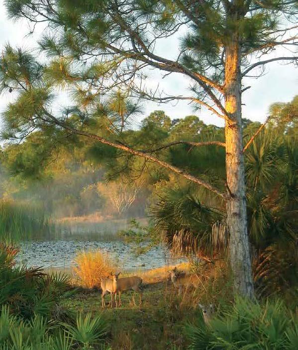
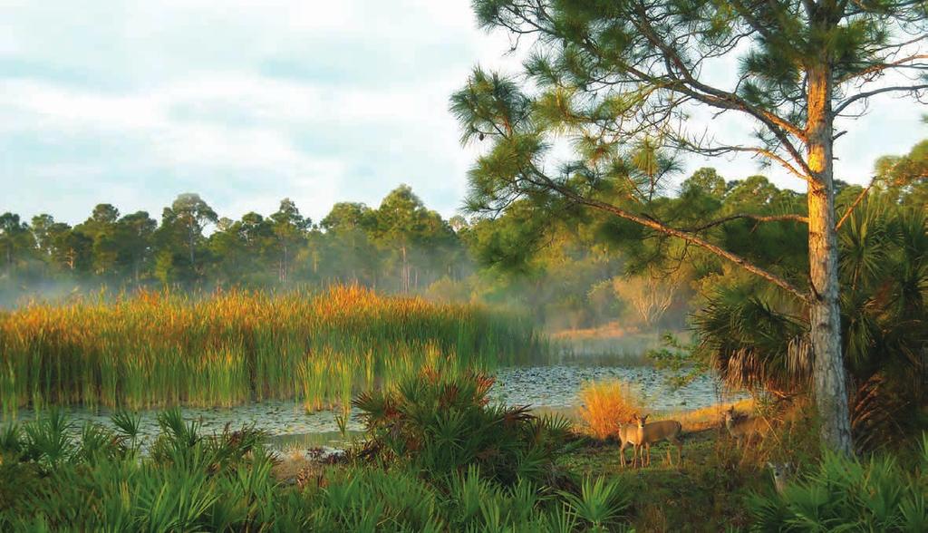
2 Get off the Beaten Path The goal of this guide is to help you discover a variety of ways to experience our community s natural areas, learn about our amazing environment and wildlife, and enjoy being active, outdoors. Sarasota County s vision is to be the premier community where people choose to live, work and play. Our network of natural areas is extensive and contributes to this goal by providing many special places to get outside, escape everyday stresses, and enjoy all that these areas have to offer. The Natural Areas Guide highlights 23 sites that feature exceptional outdoor recreational opportunities. For information on more of Sarasota County s parks, natural areas and trails visit scgov.net/parks. Get out there, share your experiences with others and enjoy! Together we can ensure that our community s investments in these lands are enjoyed by residents and visitors alike and YOU can help others get off the beaten path and discover Sarasota s natural areas.

3 Table of Contents Important Information... 2 How to use this Guide... 3 What Kind of Wild Are You?... 4 Sarasota County Wildlife... 8 Notable Species... 9 Sarasota County Park Locator Map...10 At-a-glance Guide Ainger Creek Trails Carlton Reserve Celery Fields Regional Stormwater Facility Circus Hammock Curry Creek Preserve Deer Prairie Creek Preserve Jelks Preserve Lemon Bay Park and Environmental Center Manasota Scrub Preserve Myakka Islands Point Myakkahatchee Creek Environmental Park Old Miakka Preserve Pinelands Reserve Pocono Trail Preserve Red Bug Slough Preserve Rothenbach Park Scherer Thaxton Preserve Shamrock Park and Nature Center Sleeping Turtles Preserve North Sleeping Turtles Preserve South South Venice Lemon Bay Preserve Urfer Family Park Walton Ranch...56 Heritage Stewardship...58 Be a Steward...59 More Outside Opportunities...60 Get Outside and Get Involved...Inside back cover 1

4 Important Information How to use this Guide Sarasota County has thousands of acres of natural areas to explore. Many of those included in this guide are wild, primitive and full of surprises. Please follow these guidelines to remain safe. Have a plan! Let others know where you will be and when you plan to return. Some natural area locations are remote and may have limited cellular or GPS service. Before leaving home, confirm park hours online at scgov.net/parks. Take your time and stay on the trails. Water, sunscreen, a rain jacket, insect repellent and sturdy shoes are recommended for hiking. Be aware of and respect the surroundings and wildlife. For your protection and that of the wildlife keep a safe distance from wild animals as they may behave aggressively if provoked or frightened. This guide is organized alphabetically for ease of navigation. Each page has a brief site summary that includes addresses, hours, acreage, GPS coordinates, informative facts and a trail map. We hope you will enjoy the beautiful natural areas of Sarasota County for years to come. To help you make the most of your time, we have provided a What kind of wild are you? section that highlights specific opportunities. More outdoor opportunities lets you discover more of what Sarasota County has to offer. Please keep this guide for future visits or share with friends or family. For more information about Sarasota County s natural areas, parks and trails: scgov.net (keyword parks) Sarasota County Contact Center Discover Natural Sarasota online at discovernaturalsarasota.org Visit Sarasota County Government on YouTube for virtual tours and information on some natural areas at: youtube.com/user/sarasotacounty. Be considerate of other visitors. Read and respect posted notices of land management activities, which may restrict access to certain areas. Prescribed burning, exotic or non-native plant removal and other habitat restoration may be occurring during your visit. AND LEGEND Access Point - Pedestrian Indoor Rental Accessibility Interpretive Signage PACK IN / PACK OUT Leave no trace refers to a set of outdoor ethics promoting conservation. TRAIL COURTESY YIELD A commonly used trail sharing sign. Bikers yield to hikers and horses Hikers yield to horses Enjoy the lands that have been preserved for this and future generations! In case of emergency, call 911. Bicycling Birding Boardwalk Camping Canoe/Kayak Launch Dog-friendly (leash required) Drinking Water Fishing Fitness Equipment-outdoor Grill Historical/Cultural Resource Main Entrance Nature Center Parking Picnic Shelter/Pavilion Playground Restrooms Seasonal Flooding Trails - Equestrian Trails - Paved Trails - Unpaved Wildlife Viewing PROHIBITIONS To ensure public safety and environmental protection, the following activities are not allowed: Removal of plants, animals or archaeological or cultural resources Off-road vehicles Open fires Pets, except in areas/sites designated for leashed dogs MAP LEGEND Featured Park Boardwalk Natural Area Other Park Trail Dog-friendly designated area Road/Street Trail - Equestrian Water 191 I-75 Exit Wetland/Swamp 2 3
, that call our wild places home, or discover native plants that you have never seen before,")


5 What Kind of Wild Are You? NATURE SEEKERS hope to catch a glimpse of creatures (regardless of whether they walk, crawl, swim or fly), that call our wild places home, or discover native plants that you have never seen before, like the elusive pine lily. You can explore lands prized for their vast diversity. A surprise awaits you! BEST OPPORTUNITIES LOCATOR MAP # 3 Celery Fields Regional Stormwater Facility 5 Curry Creek Preserve 7 Jelks Preserve 9 Manasota Scrub Preserve 10 Myakka Islands Point 12 Old Miakka Preserve 17 Scherer Thaxton Preserve 19 Sleeping Turtles Preserve North 20 South Venice Lemon Bay Preserve FAMILY TRAILBLAZERS are adventurers who discover the wonders of nature and create memories that will last for decades. Family-friendly areas await with paved and unpaved easy trails, playgrounds, pavilions and tables for picnics. BEST OPPORTUNITIES LOCATOR MAP # 3 Celery Fields Regional Stormwater Facility 8 Lemon Bay Park and Environmental Center 11 Myakkahatchee Creek Environmental Park 15 Red Bug Slough Preserve 16 Rothenbach Park 22 Urfer Family Park WILDLANDS ENTHUSIASTS can hear the call of the wild challenging them to experience wilderness at its finest. Expect the unexpected with hundreds of miles of primitive hiking. Sarasota County s rugged back country offers a true challenge for hikers. BEST OPPORTUNITIES LOCATOR MAP # 2 Carlton Reserve 6 Deer Prairie Creek Preserve WEEKEND WARRIORS scout the perfect picnic spot or leisurely stroll to find their next great conquest. Create a perfect weekend with short hikes, kayaking, fishing or bird watching. HERITAGE HOUNDS can explore the community s rich and unique history through its cattle ranches, settler homesteads and turpentine camps. Keep an eye peeled for historic buildings, lone cattle corrals, signs of Native American settlements and more. BEST OPPORTUNITIES LOCATOR MAP # 2 Carlton Reserve 6 Deer Prairie Creek Preserve 14 Pocono Trail Preserve 22 Urfer Family Park 23 Walton Ranch BEST OPPORTUNITIES LOCATOR MAP # 3 Celery Fields Regional Stormwater Facility 5 Curry Creek Preserve 7 Jelks Preserve 8 Lemon Bay Park and Environmental Center 11 Myakkahatchee Creek Environmental Park 12 Old Miakka Preserve 15 Red Bug Slough Preserve 19 Sleeping Turtles Preserve North 21 South Venice Lemon Bay Preserve 4 5


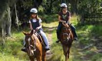
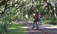
6 TRAIL TROTTERS can choose from miles of equestrian experiences, with userfriendly features like designated horse trailer parking. Please remember, state law requires all riders to carry proof of current negative Coggins results. BEST OPPORTUNITIES LOCATOR MAP # 1 Ainger Creek Trails 2 Carlton Reserve 6 Deer Prairie Creek Preserve 23 Walton Ranch SIDEWALK ADVENTURERS need firmer ground beneath them. Paved trails and accessible amenities allow Sidewalk Adventurers to enjoy the beauty of our community s natural areas. Try these sites if you seek a short walk on easy, even pavement or to be able to experience scenery without a lot of sweat equity. BEST OPPORTUNITIES LOCATOR MAP # 3 Celery Fields Regional Stormwater Facility 8 Lemon Bay Park and Environmental Center 15 Red Bug Slough Preserve 16 Rothenbach Park 18 Shamrock Park and Nature Center 22 Urfer Family Park WATER WAYFARERS whet their appetites with opportunities for boating, paddling and fishing. We have it all from blackwater rivers to gentle, quiet creeks, lakes, and adventures that take you all the way to the bay and Gulf waters. BEST OPPORTUNITIES LOCATOR MAP # 2 Carlton Reserve 5 Curry Creek Preserve 6 Deer Prairie Creek Preserve 8 Lemon Bay Park and Environmental Center 15 Red Bug Slough Preserve SHADE SEEKERS are the ones combing the area for the perfect shady walk or picnic spot. There are many areas to choose to delight your stay cool desires. BEST OPPORTUNITIES LOCATOR MAP # 4 Circus Hammock 8 Lemon Bay Park and Environmental Center 10 Myakka Islands Point 14 Pocono Trail Preserve 15 Red Bug Slough Preserve 16 Rothenbach Park 19 Sleeping Turtles Preserve North 20 Sleeping Turtles Preserve South BIKING BUFFS prefer pedals and spokes to hiking boots. Sarasota County offers Biking Buffs a variety of opportunities to enjoy the great outdoors by bicycle. Regardless of your level of experience, you ll find places that delight both the experienced rough trail bike rider and occasional cyclist. BEST OPPORTUNITIES LOCATOR MAP # 2 Carlton Reserve 6 Deer Prairie Creek Preserve 13 Pinelands Reserve 16 Rothenbach Park 18 Shamrock Park and Nature Center 22 Urfer Family Park 23 Walton Ranch 6 7


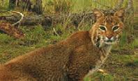
7 Sarasota County Wildlife Notable Species Sarasota County provides critical habitat for many imperiled native species. Protection and management of natural areas ensures these habitats will support future generations of wildlife as well as people. Species you might encounter in Sarasota s natural areas: FLORIDA SCRUB-JAYS Sarasota County features diverse natural communities, such as native oak scrub with sandy, dry soil. These areas provide critical habitat for the endangered Florida scrub-jay, the state s only endemic bird. BALD EAGLES State and federally protected bald eagles are found throughout the state year-round with nesting season occurring from Oct. 1 - May 15. WEST INDIAN MANATEES The warm waters of Sarasota County s bays, rivers and creeks provide protected sites for the endangered West Indian manatee. Reptiles Mammals Birds Yellow rat snake Southeastern five-lined skink Red rat snake Peninsula cooter Southern toad Gopher tortoise Green anole Black racer American alligator White-tailed deer Coyote Bobcat Wood stork White ibis Swallow-tailed kite Sandhill crane Red-shouldered hawk Red-bellied woodpecker Pileated woodpecker Osprey Limpkin Grey catbird Great egret Florida scrub-jay Carolina wren Brown thrasher Barred owl Bald eagle GOPHER TORTOISES Gopher tortoises can be found throughout much of Florida. Considered to be a keystone species, their burrows provide refuge for more that 350 other animal species, including several imperiled species. FLORIDA BOBCATS Bobcats are about twice the size of house cats, and are the most common wild feline in Florida. Home territory is one-to-five square miles, and as development increases, bobcats are becoming more comfortable in urban areas. These beautiful cats are quite stealthy, and are more common than people realize. PARKS Page Locator Map # 1 14 Ainger Creek Trails 2 16 Carlton Reserve 3 18 Celery Fields Regional Stormwater Facility 4 20 Circus Hammock 5 22 Curry Creek Preserve 6 24 Deer Prairie Creek Preserve 7 26 Jelks Preserve 8 28 Lemon Bay Park 9 30 Manasota Scrub Preserve Myakka Islands Point Myakkahatchee Creek Environmental Park Old Miakka Preserve Pinelands Reserve Pocono Trail Preserve Red Bug Slough Preserve Rothenbach Park Scherer Thaxton Preserve Shamrock Park Sleeping Turtles Preserve North Sleeping Turtles Preserve South South Venice Lemon Bay Preserve Urfer Family Park Walton Ranch 8 9
8 Locator Map At-a-glance Match the map reference numbers on the locator map to the At-a-glance Activity Guide on page FRUITVILLE ROAD STATE ROAD 72 Park number Page number Accessibility Bicycling Birding Wildlife Viewing Boardwalk Camping-Primitive Canoe/Kayak Launch Dog-friendly (leash required) Drinking Water Fishing Fitness Equipment (Outdoor) Grills Historical/Cultural Resource Interpretive Signage Nature Center Picnic Shelter/Pavilion Playground Restrooms Trails-Equestrian Trails-Paved Trails-Unpaved Miles Ainger Creek Trails Carlton Reserve Celery Fields Regional Stormwater Facility Circus Hammock Curry Creek Preserve Deer Prairie Creek Preserve Jelks Preserve Lemon Bay Park and Environmental Center Manasota Scrub Preserve Myakka Islands Point Myakkahatchee Creek Environmental Park Old Miakka Preserve Pinelands Reserve Pocono Trail Preserve Red Bug Slough Preserve Rothenbach Park Scherer Thaxton Preserve Shamrock Park and Nature Center Sleeping Turtles Preserve North Sleeping Turtles Preserve South South Venice Lemon Bay Preserve Urfer Family Park Walton Ranch
 WINCHESTER BOULEVARD The shared-use trails are popular with equestrians, off-road bicyclists and hikers seeking nature and solitude.")

9 1 AINGER CREEK TRAILS Winchester Blvd. Englewood, acres N W N W AINGER CREEK TRAILS (NORTH) WINCHESTER BOULEVARD The shared-use trails are popular with equestrians, off-road bicyclists and hikers seeking nature and solitude. Please practice trail courtesy when using the trails. Motorized vehicles are prohibited. I-75 Exit 191 to North River Road. Head south on North River Road for approximately 13 miles to Winchester Boulevard. Parking will be on the west side of Winchester Boulevard. While exploring the preserve s network of trails, visitors may observe various natural habitats including the tidal creek, slash and longleaf pine flatwoods, mesic and hydric hammocks, seasonal wetlands, marshes, mangrove tidal swamp and tidal strands. One might hear barred owls or see osprey flying above, observe fiddler crabs, jumping mullet and a wide array of wildflowers such as swamp sunflower (pictured above) in the fall, rosinweed, wild petunia, blazing star and beautyberry. Activities: hiking, biking, birding, equestrian use, wildlife viewing. More than four miles of primitive trails. A natural area where visitors can enjoy an old-florida nature experience. Dog-friendly, all dogs must be kept on a hand-held, maximum 6-foot leash. Interpretive signage Shared use trails - unpaved Lemon Bay Park and Environmental Center and Manasota Scrub Preserve. Although this preserve is divided in two by the Myakka State Forest, it is connected by the creek. Can you trace the creek on the map from North to South? What might you see in the creek when you hike? AINGER CREEK TRAILS (SOUTH) ENGLEWOOD WATER DISTRICT MYAKKA STATE FOREST CHARLOTTE COUNTY ,000 2,000 MYAKKA STATE FOREST 12 13
 was acquired in 1984.")


10 2 CARLTON RESERVE 1800 Mabry Carlton Parkway, Venice, ,565 acres N W N POWERLINE TRAIL BIG SLOUGH PRESERVE TIGER MAR S H TRAIL EXIT The T. Mabry Carlton, Jr. Memorial Reserve (Carlton Reserve) was acquired in It is a multifaceted property where protection of wetlandspeckled expanses of pine flatwood and dry prairies provide natural area conservation, unique wilderness recreation opportunities, cultural heritage preservation and public water supply safety. I-75 Exit 193-Jacaranda Boulevard. Go north on Jacaranda Boulevard for 0.9 miles. Right on Border Road, go 2.6 miles. Left on Mabry Carlton Parkway, go 0.3 miles. Follow signs to public park area on right. A true wilderness excursion with unique getting back to nature experiences. Wildlife viewing may include: whitetailed deer, turkey, bobcat, swallowtailed kite, various wading birds. You may also see plants, such as pine lily, tarflower and blue flag iris. Activities: biking, birding, hiking, primitive camping and paddling miles of trails/horseback riding. 12-mile Myakka Island Wilderness Trail continues north to Myakka River State Park. Contact for camping/ pavilion reservations. Accessible (partially) Bicycle trails - technical - 15 miles Horse trailer access Picnic pavilion - reservable Picnic tables and grills Primitive camping (permit required) Restrooms Self-guided interpretive trails Trails - equestrian Trails - unpaved Visitor center / historic cabin Deer Prairie Creek Preserve, Sleeping Turtles Preserve North. The site was named for T. Mabry Carlton, Jr., a former Sarasota County commissioner and fifth generation Florida cattle man who was instrumental in the reserve s acquisition. The reserve remains a hallmark of Sarasota s legacy of stewardship. MYAKKA RIVER STATE PARK BEAR HAMMOCK TRAIL PINELANDS RESERVE STOC KADE TRAIL RIVER TRAIL VENICE - ARCADIA GRADE WELLFIELD ROAD WATER PLANT LAUREL ROAD S POWERLINE TRAIL BORDER ROAD MABRY CARLTON EXIT Miles PARKWAY 14 15


 Boardwalks Interpretive signage Picnic tables Restrooms Trails - unpaved Ackerman Park, Colonial Oaks Park, Nathan Benderson")


11 3 CELERY FIELDS REGIONAL STORMWATER FACILITY 6799 Palmer Blvd. Sarasota, acres N W EXIT 210 FRUITVILLE LIBRARY FRUITVILLE ROAD ACKERMAN PARK The Celery Fields Regional Stormwater Facility is an important regional stormwater facility, handling runoff from 3,500 acres of the upper Phillippi Creek Basin. Historically farmed as celery fields, the existing wetlands were created to improve water quality and provide important wildlife habitat. I-75 Exit Fruitville Road/FL-780. East on Fruitville Road for 0.7 miles. Right on Coburn Road for 0.7 miles. Continue on Apex Road, for 0.4 miles. Left on Palmer Boulevard, for 0.8 miles. Entrance is on the left. Seven miles of trails. Dog-friendly, all dogs must be kept on a hand-held, maximum 6-foot leash. Accessible (partially) Boardwalks Interpretive signage Picnic tables Restrooms Trails - unpaved Ackerman Park, Colonial Oaks Park, Nathan Benderson Park and Sarasota Audubon Nature Center. PALMER BOULEVARD The site provides varied terrain to walk, run or hike. Wildlife viewing may include a wide range of birds, as well as many migratory birds. You may see herons, black-necked stilt, ibis, terns, anhinga, cormorant, limpkin, sparrows and wrens. The Sarasota Audubon Society has noted at least 225 species. Activities: birding and hiking. Observation mound and two boardwalks with views of the wetlands. Popular for birding enthusiasts and is noted in the Great Florida Birding Trail. This area was a rich muckland known as Big Camp Saw Grass and Tatum Saw Grass prior to being developed as vegetable fields in the early 1920 s by the Sarasota-Venice Company. The site has historically been and continues to be a birding hotspot with over 225 species identified ,000 2,

. Preserve entrance is on the right.")
12 4 CIRCUS HAMMOCK th St. Sarasota, acres N W TH STREET 17 ST This urban preserve protects a diverse assemblage of plants and provides a beautiful, peaceful green space in the midst of residential neighborhoods. You will meander through the shady hammock of oaks, red maple, hackberry and American elm. I-75 Exit Fruitville Road/FL-780. Travel west on Fruitville Road, turn right on Honore Avenue. Turn left on 17th Street. Turn left into 17th Street Park (west entrance). Preserve entrance is on the right. Parking area is on your left at 17th Street Dog Park, just a short walk to the preserve s entrance. A shady refuge in Sarasota s city limits with wildlife viewing, which may include woodpeckers, box turtle, red-shouldered hawk, barred owl and migratory song birds such as warblers. Activities: birding, picnicking and hiking. 1.5 miles of shady trails Dog-friendly, all dogs must be kept on a hand-held, maximum 6-foot leash. Trails - unpaved 17th Street Park and Dog Park, Fruitville Park and Nathan Benderson Park. Circus Hammock is located near the original historic winter quarters of the Ringling Bros. and Barnum & Bailey Circus. BOBBY JONES GOLF COURSE TH STREET PARK AND DOG PARK 17 ST PARK AND PAW PARK 18 19


13 5 CURRY CREEK PRESERVE 1500 Pinebrook Road Venice, East entrance 1075 Albee Farm Road Venice, West entrance 80 acres East entrance N W West entrance N W PINEBROOK ROAD PINEBROOK PARK This preserve protects rare coastal longleaf pine flatwoods while providing valuable open space for a growing community. Visitors will delight in the variety as scrub and pine flatwoods blend into tidal marshes and swamps along the creek s edge. East entrance: from I-75 Exit Laurel Road East. Travel west on Laurel Road East. Turn left on Pinebrook Road. Entrance on the right, limited parking along easement. Entrance on the right, opposite Water Street. Limited parking near entrance. West entrance: from I-75 Exit Laurel Road East. Travel west on Laurel Road East. Turn left on Albee Farm Road North. Entrance and parking area are on the left, close to walk-through access and kayak launch. Entrance and parking area located south of Colonia Lane, on the left, close to walk-through access and kayak launch. Mangroves and giant leather ferns line the creek. Wildlife viewing may include: gopher tortoise, alligator, bobcat, bald eagle and wading birds such as the herons, ibis and limpkins. Activities: birding, fishing, hiking and paddling. Just over 1.5 miles of trails with views along Curry Creek. West entrance - kayak launch. Dogfriendly designated area only on west side of preserve. All dogs must be kept on a hand-held, maximum 6-foot leash. Canoe/kayak launch Interpretive signage Picnic tables Trails - unpaved Nokomis Community Park, Pinebrook Park, Pocono Trail Preserve, The Legacy Trail, Wellfield Park. Curry Creek is one of the few remaining coastal creeks in southwest Florida and is named for the Curry family, early pioneers that settled the area. Take a virtual tour at: youtu.be/mt5kpq9fz ,000 ALBEE FARM ROAD 20 21


14 6 DEER PRAIRIE CREEK PRESERVE South Tamiami Trail Venice, South entrance 7001 Forbes Trail Venice, North entrance 6,439 acres North entrance N W South entrance N W LINCER PRESERVE FORBES TRAIL CARLTON RESERVE SCHEWE RANCH OAK CATHEDRAL PRESERVE JELKS PRESERVE SCHEWE RANCH This preserve protects the floodplain of the Myakka River, a designated Wild and Scenic River. The preserve features pine flatwoods, prairie hammock and seasonal wetlands, providing scenic overlooks along the Myakka River and Deer Prairie Creek. North entrance: I-75 Exit Jacaranda Boulevard. North on Jacaranda Boulevard. Right on Border Road Right on South Moon Drive. Left on Forbes Trail. Entrance on right with horse trailer parking. South entrance: I-75 Exit North River Road Turn left on US-41/South Tamiami Trail. Make U-turn at Lazy River Road, entrance is on right. Parking area is one mile into the preserve. A wilderness lover s dream for nature hiking. Wildlife viewing may include: gopher tortoise, alligator, river otter, wild turkey, swallow-tailed kite, Florida scrub-jay, wading birds. Plants include: St. John s wort, tarflower and pine lily. Activities: birding, fishing, hiking, paddling, and picnicking. 70 miles of trails through diverse habitats. Horseback riding trails accessible from north entrance only. Dog-friendly, all dogs must be kept on a hand-held, maximum 6-foot leash. Accessible paved path to picnic table - south entrance Canoe/kayak launch - south entrance Horse trailer access - north entrance Interpretive signage Picnic shelters with tables Trails unpaved Carlton Reserve, Jelks Preserve and Senator Bob Johnson s Landing. The preserve contributes to complete protection of the Deer Prairie Creek in Sarasota County and nearly six miles of the Myakka River s east bank. Take a virtual tour at: youtu.be/ipyux9cyjay. RIVER ROAD 41 MYAKKA RIVER Miles 22 23


15 7 JELKS PRESERVE 2300 N. River Road Venice, acres SLEEPING TURTLES SOUTH SNOOK HAVEN N W DEER PRAIRIE CREEK PRESERVE Acquired in 1999 with generous support of the Jelks Family Foundation, the preserve borders the Myakka River, forever protecting a piece of the riverine floodplain. Visitors will traverse through a varied landscape of hammocks, pine flatwoods, and seasonal wetlands. I-75 Exit North River Road. Travel southeast on North River Road for 1.4 miles. Entrance is on left, parking area located near entrance and walkthrough access. Dog-friendly, all dogs must be kept on a hand-held, maximum 6-foot leash. Picnic tables Trails - unpaved Deer Prairie Creek Preserve, Senator Bob Johnson s Landing, Sleeping Turtles Preserve South and Snook Haven Park. RIVER ROAD CENTER ROAD MYAKKA RIVER Some trails may be cool as you stroll to the river through canopy hammocks, others may be open and sunny as they cross pine flatwoods. Wildlife viewing may include: gopher tortoises, swallowtail butterflys and swallow-tailed kites, song birds and an assortment of wildflowers, such as Carolina jessamine and coralbean. Activities: birding, fishing, hiking and picnicking. Eight miles of trails through a diverse landscape. Visitors can view the river at three different locations, while walking in the shade of mature live oak trees, full of epiphytes. Take a virtual tour at: ,000 2,000 Scenic vistas of the Myakka River


16 8 LEMON BAY PARK AND ENVIRONMENTAL CENTER 570 Bay Park Boulevard Englewood, acres N W BAYSHORE DRIVE Lemon Bay Park has preserved the pine and scrubby flatwoods and natural shoreline along Lemon Bay. Tucked in an urban location, the park also provides outdoor recreation and environmental education. From I-75 Exit Jacaranda Boulevard. Go south on Jacaranda Boulevard toward Englewood for 5.1 miles. Left on FL-776/Englewood Road, go 4.1 miles. Right on Old Englewood Road, go one mile. Slight right on Kilbourne Avenue, go 0.2 miles. First right on Morrison Avenue, then first left on Curtis Boulevard. First right on Brengle Avenue. Entrance and parking ahead. 3.5 miles of trails including boardwalks with scenic overlooks of Lemon Bay. Dog-friendly, all dogs must be kept on a hand-held, maximum 6-foot leash. Accessibility Boardwalk, scenic overlook Butterfly garden Canoe/kayak launch Indoor rental space Interpretive signage Picnic shelter with tables Restrooms Trails - paved and unpaved Indian Mound Park, Manasota Scrub Preserve, Englewood Sports Complex, Buchan Airport Community Park. LEMON BAY GASPARILLA BOULEVARD NATURE CENTER BAY VISTA BOULEVARD OHIO AVENUE OHIO AVENUE Varied tree and wildflower species: lupine, palafox, coontie and Curtis milkweed. Wildlife viewing may include: gopher tortoise, grey fox, bobcat, river otter, raccoon, butterflies, and a variety of birds such as anhinga, bald eagle, snowy egret, flycatchers and frigates. Activities: birding, fishing, hiking, kayaking, strolling through the butterfly garden, attending seasonal programs. Picnic pavilion and indoor meeting space available. Contact for reservations. Visitors can explore the longest remaining intact and contiguous natural area mangrove shoreline in Sarasota County, home to three pairs of nesting bald eagles. Will Randall ,000 STEWART STREET 26 27
 SHANE ROAD 5TH STREET BRIDGE STREET Manasota Scrub Preserve is home to some of the county s remaining scattered pockets of scrub habitat.")

17 9 MANASOTA SCRUB PRESERVE 2695 Bridge St. Englewood, acres N W ENGLEWOOD ROAD (SR 776) SHANE ROAD 5TH STREET BRIDGE STREET Manasota Scrub Preserve is home to some of the county s remaining scattered pockets of scrub habitat. The system of trails and a boardwalk offers picturesque views of a variety of upland and wetland habitats right within a suburban community. I-75 Exit Jacaranda Boulevard. Go south on Jacaranda Boulevard toward Englewood for 5.1 miles. Left on Englewood Road go 1.6 miles. Right on Manasota Beach Road, go 0.2 miles. Left on Bridge Street, entrance on left with limited parking. Unwind and enjoy nature on one of the benches that you will find along the trail, and overlooking the pond. Wildlife viewing may include: gopher tortoise, wood ducks, swallowtail butterflies and great horned owls. Activities: birding, hiking and picnicking. 1.5 miles of trails, some of which experience seasonal flooding. A variety of wildflowers such as grassleaf, goldenaster and blazing star. Dog-friendly designated area (east of Bridge Street and north of 5th Street only). All dogs must be kept on a hand-held, maximum 6-foot leash. Accessibility (partial) Picnic tables Trails - unpaved Lemon Bay Park, Manasota Beach, Shamrock Park, South Venice Lemon Bay Preserve and Venice Area Audubon Rookery. The preserve is named for the predominant habitat and one of the earlier landowners, the Manasota Land and Timber Company. MANASOTA BEACH ROAD SHELL DRIVE MANASOTA BEACH ROAD DESIGNATED AREA ONLY ,000 5TH STREET 28 29


18 10 MYAKKA ISLANDS POINT 1289 Campbell St. Port Charlotte, acres N W MYAKKA STATE FOREST Myakka Islands Point is an ecologically productive and important site. The expansive tidal marsh that surrounds an island of upland flatwoods provides habitat for wading birds and fish. Catching a glimpse of the Myakka River, it s easy to understand this region s historic associations with fishing, navigable waterways and Native American culture. Two miles of trails with wonderful views of the Myakka River, Charlotte Harbor and tidal marshes. A bountiful array of natural coastal communities rich with history. Trails - unpaved Dallas White Park, Myakka State Forest and Marina Park. CHARLOTTE COUNTY I-75 Exit North River Road. Go south on North River Road toward North Port for 5.5 miles. Left on US-41 South Tamiami Trail, go 4.1 miles. Right on North Port Boulevard, go 0.8 miles. Right on Chancellor Boulevard, go one mile. Chancellor Boulevard turns left and becomes Campbell Street, go south on Campbell Street 1.4 miles. Entrance and parking on right. Tidal marsh views. Wildlife may include: American kestrel, swallowtailed kite, a variety of wading birds and amphibians. Activities: birding and hiking. Visitors may observe species such as American kestrels and bald eagles, as well as a variety of wading birds, amphibians and various wetland plants. MYAKKA RIVER


19 11 MYAKKAHATCHEE CREEK ENVIRONMENTAL PARK 6968 Reisterstown Road North Port, Dawn to dusk 162 acres N W NORTH SALFORD BOULEVARD BRIDGE BRIDGE TROPICAIRE BOULEVARD This park is owned by the city of North Port and operated by Sarasota County. The shared-use trails are popular with equestrians, off-road bicyclists and hikers seeking nature and solitude. Motorized vehicles are prohibited. Please practice trail courtesy when using shared-use trails. I-75 Exit 182 Sumter Boulevard. Head north on Sumter Boulevard for approximately one mile, head left on Tropicaire Boulevard for approximately 1/2 mile, take the first right on to Reisterstown Road and follow it for approximately one mile. The park entrance will be on your right. Great views of Myakkahatchee Creek. Wildlife viewing may include: a wide a variety of birds, alligators, turtles, fish, deer, bobcats and gopher tortoises. Activities: hiking, horseback riding and primitive camping (by reservation). Four miles of multi-use trails along a blackwater creek lined with centuryold oaks. A natural area where visitors can enjoy an old Florida nature experience. Trailhead to Eastern Ranchlands, including Carlton Reserve. Dog-friendly, all dogs must be kept on a hand-held, maximum 6-foot leash. Grills Hitching posts Picnic tables Picnic shelter (small) Potable water for horses Primitive campsite (permit required) Scenic overlook Trails - equestrian Trails - unpaved Water fountain Carlton Reserve, Deer Prairie Creek Preserve and Walton Ranch. KIDS CORNER See if you can find the scenic wooden footbridge that is located over the creek. If you are lucky you may see a horseback rider sharing the trail. BIG SLOUGH PRESERVE CARLTON RESERVE ESTATES DRIVE REISTERSTOWN ROAD ,000 BRIDGE 32 33


20 12 OLD MIAKKA PRESERVE 251 Myakka Road Sarasota, acres N W WHIDDEN ROAD The preserve is named for Old Miakka, the historic rural community where the preserve is located. Enjoy the variety of plant life here that inspired Tim Cash ( ), a local nursery owner and founding member of the Serenoa Chapter of the Florida Native Plant Society, who was also active in the Old Miakka community. A trail named in his honor passes through subtle changes in habitat, allowing visitors to experience the natural diversity that Tim admired. Four miles of unpaved trails through systems of hammocks and seasonal wetlands. 1.5 mile Tim Cash Loop Trail. Interpretive signage Picnic shelter with table Trails - unpaved Myakka River State Park. I-75, Exit 210-Fruitville Road, east on Fruitville Road for 11.3 miles. Continue straight on Fruitville Road Extension for.04 miles. Entrance and parking on right, inside the gate. Experience the tranquil beauty of this preserve with wildlife viewing that may include: gopher tortoise, swallow-tailed kite, migratory song birds. Plants such as longleaf pine, scrub oaks, Florida paintbrush and pawpaw are plentiful. Activities: birding, hiking and picnicking Old Miakka Preserve has the highest natural elevation of any county park. The elevation reaches a height of 54 feet. FRUITVILLE ROAD EXTENSION MYAKKA ROAD


21 13 PINELANDS RESERVE 4000 Knights Trail Road Nokomis, ,151 acres N W COWPEN SLOUGH NO PUBLIC ACCESS NO PUBLIC ACCESS Pinelands Reserve is a 5,601-acre site that surrounds the Central County Solid Waste Disposal Complex. Currently, a small portion of the reserve is open to the public, with more access and trails planned for the future. Enjoy hiking through diverse natural communities. Please practice trail courtesy when hiking trails. Motorized vehicles are prohibited. I-75, Exit 195-Laurel Road. Go east on Laurel Road for 0.25 miles. Turn left onto Knights Trail Road, travel two miles. Entrance is on the right; limited parking is located near the entrance. Great views of wildlife may include: bald eagles, a wide variety of birds, alligators, turtles, fish, deer, bobcats and gopher tortoises. Activities: birding, hiking, horseback riding and wildlife viewing. 1.5 miles of hiking trails. While touring the reserve you will enjoy a diverse vegetation community, including pine flatwoods, upland mixed forests, lakes and seasonal wetlands and a myriad of native wildflowers. Dog-friendly, all dogs must be kept on a hand-held, maximum 6-foot leash. Interpretive signage Picnic tables Trails - unpaved Curry Creek Preserve, Pocono Trail Preserve and Scherer Thaxton Preserve. The protected Sherman s fox squirrel is bigger than your average squirrel! It is found in the open pine flatwoods of central and northeastern Florida, and eats mostly plants, but sometimes insects and bird eggs. KNIGHT TRAIL PARK KNI GHT TRAIL R OAD KNIGHT TRAIL ROAD PUBLIC ACCESS AREA ROCKY FORD CARLTON RESERVE Miles MYAKKA RIVER STATE PARK 36 37


22 14 POCONO TRAIL PRESERVE 189 Pocono Trail Nokomis, acres N W SHAKETT CREEK The preserve maintains the health of the Shakett Creek estuary system, providing important habitat, open space and water access along a major urban corridor. Shady trails meander beneath picturesque live oaks and slash pines offering occasional glimpses of the creek. I-75 Exit 195/Laurel Road. West on Laurel Road for 2.8 miles. Left on U.S. 41 and go south 1.7 miles. Left on Colonia Lane, go 0.3 miles. Take a third left on Pocono Trail East, go 0.2 miles. Entrance on right. Limited parking. Dog-friendly, all dogs must be kept on a hand-held, maximum 6-foot leash. Picnic tables Scenic overlook Trails - unpaved Nokomis Community Park, The Legacy Trail, Curry Creek Preserve and Laurel Park. 41 POCONO TRAIL EAST COLONIA LANE EAST Enjoy the maritime hammock, tidal swamp and scrubby flatwoods. Wildlife viewing may include: ospreys, grey squirrels, and a variety of wading birds. Activities: birding, hiking, picnicking and nature photography. One mile of shady trails right on Shakett Creek. Close to U.S. 41 and various restaurants. Pocono Trail Preserve was originally named by Dr. Fred Albee, an early settler of Nokomis and owner of the Pollyanna Inn, which was located on this property and opened in Take a virtual tour at: youtu.be/xd1dk8r3vle


23 15 RED BUG SLOUGH PRESERVE 5200 Beneva Road Sarasota, acres N W BENEVA ROAD Red Bug Slough Preserve is a small oasis of natural Florida in the midst of suburban Sarasota. The slough, named for the cotton stainer bug, flows through the preserve and forms a calm lake. Hiking and biking trails through the preserve are shaded by pines and loblolly bay that give way to oaks draped with Spanish moss. I-75 Exit Bee Ridge Road/FL-758. Go west on Bee Ridge Road for 2.9 miles. Turn left onto Beneva Road, for 1.4 miles. Entrance is on the right with limited parking available a short distance from a walk-through access. Butterfly garden featuring Florida native plants. Dog-friendly, all dogs must be kept on a hand-held, maximum 6-foot leash. Accessible restrooms Boardwalk Fishing pier Interpretive signage Picnic shelters with tables Playground Trails - unpaved Bee Ridge Park, Phillippi Estate Park, Urfer Family Park. PROCTOR ROAD ELMER STREET SOUTH LOCKWOOD RIDGE ROAD ASHTON ROAD Destress as you stop to rest on one of the park benches that overlook the lake. Bring a picnic to enjoy at the picnic shelter. Wildlife viewing may include: grey squirrel, marsh rabbit, river otter, and occasional alligator, migratory song birds, wood ducks and plants, such as partridge pea, string lily, milkweed, passionflower and frostweed. Activities: biking, birding, hiking, picnicking, fishing, nature photography and playground. Two miles of shaded and sunny trails with water views. Red Bug Slough is a shallow, slowmoving body of water that filters and improves the quality of water entering Sarasota Bay. Take a virtual tour at: youtu.be/0qqpijec7dg. Will Randall NUTMEG AVENUE CAMPHOR AVENUE GYPSY STREET ,


24 16 ROTHENBACH PARK 8650 Bee Ridge Road Sarasota, acres N W Rothenbach Park is a closed and capped landfill that has been recycled into open vistas. It is a prime example of turning trash into treasure! The amenities include advanced recycling and sustainable building techniques and materials. Named for Walter J. Rothenbach, Jr., a 40-year employee of Sarasota County and former director of Parks and Recreation. Accessibility Interpretive signage Picnic pavilion - reservable Picnic tables Playground - accessible Restrooms Trails - paved Lakeview Park and Dog Park and Celery Fields Regional Stormwater Facility.!( RC FLYERS I-75 Exit Bee Ridge Road. Go east on Bee Ridge 3.1 miles, turn right 0.2 miles into the park. Follow park road veering right to the entrance. Two playground areas with a variety of playground equipment on a soft mulch surface. Wildlife viewing may include: white-tailed deer, American alligator, armadillo, meadowlarks, red-shouldered hawk, black-bellied whistling duck, wood ducks, coot, moorhen, herons, rabbits and woodpeckers. Activities: birding, hiking, picnicking and playground. Five miles of varied elevation, paved trails, both sunny and shaded. Picnic pavilion available for reservation. For more information contact Florida has the richest epiphyte flora in the United States, with approximately 85 species of native air plant ferns and flowering plants. A walk along the shaded hammock trail provides multiple opportunities for epiphyte viewing. BEE RIDGE ROAD BEE RIDGE ROAD EXTENSION ,000 1,


25 17 SCHERER THAXTON PRESERVE Honore Ave. Osprey, acres N W This property was acquired in 1992 to continue the natural landscape and wildlife corridor adjacent to the Mary Thaxton Memorial Preserve of the Oscar Scherer State Park. Elsa Scherer Burrows left her family s ranch to the state in memory of her father, Oscar. Former Sarasota County Commissioner Jon Thaxton, a local Florida scrubjay expert, led the effort to protect additional lands adjacent to the park. From north: I-75 Exit SR 681 South toward Venice/Osprey. Go south on SR 681, turn right on Honore Avenue, entrance and parking on left. A diverse variety of Florida flowering plants and seasonal explosions of color. Dog-friendly, all dogs must be kept on a hand-held, maximum 6-foot leash Canoe/kayak launch Interpretive signage Picnic tables Trails - unpaved Culverhouse Nature Park, Curry Creek Preserve, The Legacy Trail and Oscar Scherer State Park. OSCAR SCHERER STATE PARK ") 681 From south; take U.S. 41 north to Central Sarasota Parkway, turn right, go to Honore Avenue, travel south, entrance and parking on right. As you hike, keep an eye out for the scarce Florida scrub-jay or a soaring eagle. Habitats include pine flatwoods and depressional wetlands. Activities: biking, birding, fishing, hiking, paddling and wildlife viewing. Loop trail around the lake and connecting trails to Oscar Scherer Park (entrance fee). Seasonal trail flooding can occur. Did you know that this preserve depends on flooding and fire? Intermittent floods and fires shape the habitat allowing grasses and wildflowers to dominate the understory. HONORE AVENUE ,


26 18 SHAMROCK PARK AND NATURE CENTER 3900 Shamrock Drive Venice, acres N W CASPERSEN BEACH PARK The park balances several community activities while providing opportunities for nature study, educational hikes and environmental programs, as well as facilities for active recreation. As a trailhead for the Venetian Waterway Park, it allows visitors to walk, bike or roller blade from the park to downtown Venice, the historic Venice Train Depot and The Legacy Trail. I-75 Exit 200 SR 681 South toward Venice to North Tamiami Trail/U.S. 41. Left onto North Tamiami Trail to Venice Bypass to Shamrock Drive, right on Shamrock Drive to park entrance on right. Parking areas are near the Nature Center, park amenities and trails. Dog-friendly, all dogs must be kept on a hand-held, maximum 6-foot leash. Accessibility Basketball courts - outdoor Demonstration garden Nature center with interpretive signage Picnic shelters with tables Picnic pavilion - reservable Playground, toddler and school-aged areas Restrooms Tennis courts Trails - paved and unpaved Caspersen Beach, The Legacy Trail, South Venice Lemon Bay Preserve and Venetian Waterway Park. SHAMROCK DRIVE Come take a beautiful trail walk along the Intracoastal Waterway (ICW) or shoot some hoops. Wildlife and scenic viewing may include: gopher tortoise, osprey, Florida scrub-jay, and views of the ICW. Activities: birding, hiking, basketball and tennis. Recreational pavilion and indoor meeting/classroom space. For reservations, contact Trailhead for the Venetian Waterway Park (trail). Will Randall Gopher tortoises may live more than 60 years and dig burrows up to 40 feet long and 10 feet deep. These burrows are used by nearly 350 other kinds of animals, including insects, snakes, rodents, toads and spiders. INTRACOASTAL WATERWAY CASPERSEN BEACH PARK GULF OF MEXICO


27 19 SLEEPING TURTLES PRESERVE NORTH 3462 Border Road Venice, acres N W CARLTON RESERVE Sleeping Turtles Preserve North provides multiple passive recreation opportunities and preserves the character and quality of the Myakka River. The preserve s trails wind through floodplain swamps and pine flatwoods and offer views of the river where visitors might see sleeping turtles basking on fallen trees. I-75 Exit Jacaranda Boulevard. Go north on Jacaranda Boulevard for 0.9 miles. Turn right onto Border Road, travel two miles. Entrance is on the left, limited parking is located near the entrance. Dog-friendly, designated area is only on the portion of the preserve north of Border Road. All dogs must be kept on a hand-held, maximum 6-foot leash. Horses are allowed on the preserve south of Border Road. Interpretive signage Picnic shelters with tables Trails - equestrian Trails - unpaved Carlton Reserve, Deer Prairie Creek Preserve-North Entrance. NORTH JACKSON ROAD BORDER ROAD Visitors will enjoy amazing views of the Myakka River and diverse natural communities, including upland mixed forests and seasonal wetlands. Wildlife viewing may include: gopher tortoises, swallow-tailed kites, alligators, snakes and migratory song birds. Activities: birding, fishing and hiking. 4.7 miles of trails with breathtaking views of the Myakka River. The preserve is named after Sleeping Turtles, a landmark on the Myakka River noted on naval maps from the 1800s ,


28 20 SLEEPING TURTLES PRESERVE SOUTH 2800 N. River Road Venice, acres N W SOUTH MOON DRIVE MYAKKA RIVER Sleeping Turtles Preserve South provides shady hiking trails through oak hammocks and pine flatwoods. It is bordered on the east by the Myakka River and has a large manmade lake in the center of the preserve. Fishing, hiking and birding are some of the nature-based recreational activities available. From I-75 Exit 191- North River Road. Travel southeast on North River Road for 0.6 miles. Entrance is on the left. Limited parking just before Venice Avenue. Walk-throughs are located off of North River Road near East Venice Avenue and near the southeast corner, near the intersection of North River Road and the I-75 southbound ramp. 5.5 miles of trails with one leading to a view of the Myakka River. An approximately one-mile trail encircles a 20-acre lake. Interpretive signage Picnic shelters with tables Trails - unpaved Carlton Reserve, Deer Prairie Creek Preserve, Jelks Preserve and Snook Haven. RIVER ROAD MYA KK A RIVER Bring your fishing pole, and stroll around the 20-acre lake until you find your secret spot. The one-mile trail offers several benches and picnic tables to take in the view, go hiking or enjoy a waterfront picnic. Wildlife viewing may include: gopher tortoises, swallow-tailed kites, alligators, snakes and migratory songbirds. Activities: birding, fishing, hiking. This man-made lake was created from a borrow pit (an excavation in which material is removed to serve as fill for another site). The fill was used in the construction of I-75 in the early 1970s. EAST VENICE AVENUE ,


29 21 SOUTH VENICE LEMON BAY PRESERVE 6200 Osprey Road Venice, Kenisco Road Venice, acres 6200 Osprey Road N W Kenisco Road N W A peaceful retreat for visitors and a refuge for several protected animals and plants. Tucked in an urban location, the park provides opportunities for outdoor recreation and environmental education. I-75 Exit 210-Jacaranda Boulevard. Go south toward Englewood/Venice for 5.1 miles. Left on Englewood Road, go 1.6 miles. Right on Manasota Beach Road, go 0.2 miles. Slight right on Belvedere Road, go 0.3 miles. Right on Pheasant Road, go 0.2 miles. Left on Macon Road, go 0.2 miles. Left on Osprey Road. Entrance is south of the intersection of Macon Road and Osprey Road, with limited parking. Look for plants such as mangroves, cord grasses, oak species, lupine, palafox, coontie, and Curtis milkweed. Wildlife viewing may include: gopher tortoises, Florida scrub-jays, bald eagles, river otters and an assortment of snakes, including the Eastern coachwhip. Approximately eight miles of trails, including a 1.6-mile scenic trail. Boardwalks Interpretive signage Trails - unpaved Picnic shelters with tables Manasota Scrub Preserve, Shamrock Park, Lemon Bay Park. This preserve contains some of the last remaining undeveloped bay shorelines, which protect the water quality and health of the Lemon Bay Estuary, a state aquatic preserve for which it was named. GULF OF MEXICO LEMON BAY KENISCO ROAD OCELOT ROAD ,000 1,500 COLONIAL ROAD OSPREY ROAD ALAMANDER AVENUE Activities: birding, fishing, hiking and picnicking


30 22 URFER FAMILY PARK 4000 Honore Ave Sarasota, a.m. to 10:00 p.m. 55 acres N W HONORE AVENUE This wonderful park offers accessible fitness equipment along the paved multi-use trails, multiple playgrounds, nature trails, views of cattle grazing, self-guided tours at the historic Dr. C.B. Wilson House and more! I-75 Exit Bee Ridge Road Go west on Bee Ridge Road for 0.9 miles. Left on Honore Avenue. Entrance and parking area immediately on the right. Ideal for family reunions or organized events - offering playgrounds, a fitness trail, one-mile nature trail winding through pine flatwoods, and adjacent to herbaceous and forested wetlands. Wildlife viewing may include: raccoons, gopher tortoises, turtles, various snakes, birds and bobcats. Activities: birding, fitness trail, hiking and picnicking. Two miles of easy nature trails among diverse ecosystems, including boardwalks over wetlands. Picnic pavilion available for reservation. Contact Dog-friendly, all dogs must be kept on a hand-held, maximum 6-foot leash. Accessibility Boardwalks Fitness trail with exercise equipment Historical/Cultural Interpretive signage Picnic shelters with tables Two accessible playgrounds - toddler/teen Restrooms Trails - paved and unpaved Celery Fields Regional Stormwater Facility, Colonial Oaks Park, Rothenbach Park, Red Bug Slough Preserve. This was Sarasota County s first Gold LEED certified park (2011), representing a new milestone in sustainability and livability in a suburban setting. BEE RIDGE ROAD


31 23 WALTON RANCH 7020 N. Toledo Blade Blvd. North Port, ,760 acres N W Walton Ranch is an active cattle ranch with beautiful natural areas. The shared-use trails are popular with equestrians, off-road bicyclists, birders and hikers seeking nature and solitude. Motorized vehicles and dogs are prohibited. Please practice trail courtesy when using shared-use trails. Interpretive signage Picnic tables Water for horses at stock tanks Trails - unpaved Deer Prairie Creek Preserve and Myakkahatchee Creek Environmental Park. From I-75 take Exit 179 Toledo Blade Boulevard. Head north on Toledo Blade Road for approximately 1.6 miles, the entrance will be on the right, straight ahead. Great views of wildlife may include: gopher tortoises, alligators, and of wide variety of birds, including caracara and wild turkey. Visitors can also observe a wide array of wildflowers, such as narrow-leaf sunflower and blue flag iris. Activities: biking, bird watching, equestrian use, wildlife and cattle viewing. There are more than 19 miles of shared-use primitive trails in the nongrazing areas. Cattle grazing in the pasture areas (please do not intentionally disturb). Florida has the longest history of ranching in any state in the United States. The first cattle arrived with the earliest Spanish explorers more than 400 years ago. When pioneer settlers came to Florida in the mid-1800s, they established a cattle industry that is still active today. TOLEDO BLADE BOULEVARD Miles 56 57


32 Heritage of Stewardship Be a steward Stewardship is a unique and important part of Sarasota County s rich heritage. This heritage is reflected in our voter-adopted land acquisition programs. The citizens of Sarasota County, demonstrating their understanding of the ecological, historical and cultural value of natural areas, have chosen to preserve open spaces for wildlife habitat, to maintain plant diversity, protect watersheds, and provide outdoor recreation. They voted twice, once in 1999 and again in 2005, to pass an ad valorem tax referendum to support land conservation. The natural areas and parklands protected through these initiatives can serve to create a community legacy by protecting sensitive resources and providing outdoor recreation for current and future generations. While you are exploring the county s natural areas, you may see our environmental professionals in action, working to restore and maintain the sites through activities such as vegetation reduction, prescribed fire, managed grazing, invasive plant management and related activities. Our ecosystem management seeks to restore and maintain a natural balance which preserves the quality of these diverse landscapes for the benefit of visitors and wildlife. Monitoring, often facilitated by volunteers, enables us to gauge our effectiveness and develop responsive approaches. This balanced, adaptive program continues Sarasota County s history of stewardship to maintain ecological functions, preserve diverse habitats, and provide recreation for residents and visitors to enjoy our community s wild places. Will Randall Help protect wildlife - Sarasota County is home to many threatened species, including Florida scrub-jays, gopher tortoises, and eastern indigo snakes. Help protect these creatures by observing them from a distance, and making sure that your pets are leashed at all times while in dog-friendly parks. Other notable info: Florida Fish and Wildlife Conservation Commission: myfwc.com Recreational Fishing License: myfwc.com (keyword license) To report wildlife violations, contact Wildlife Alert: Go native - Native plants provide valuable habitat for wildlife. Consider using native plants and removing invasive exotic species from landscaping. Sarasota County s Cooperative Extension Service provides free landscaping advice: sarasota.ifas.ufl.edu. Report suspicious activity - While the lands are open to the public, not all activities are authorized. Visitors are limited to posted hours. Motorized vehicles, including all-terrain vehicles (ATVs), are not permitted beyond parking areas. If you observe unauthorized access or suspicious activity, contact the Sarasota County Sheriff s Office non-emergency number at Please report fence and gate damage or illegal dumping to and include park name and location

 or Friends of Sarasota County Parks at foscp.org.")

, or who wish to file a complaint, should contact Sarasota County ADA / Civil Rights Coordinator, 1660 Ringling Blvd.")
33 Get outside and get involved Looking for a way to make a difference? Volunteer your time and talent! There are a variety of volunteer opportunities available with Sarasota County Parks, Recreation and Natural Resources. You decide how much time you want to volunteer and we ll match your skills and interests to activities you ll enjoy. To register with Volunteer Sarasota, visit scgov.net (keyword volunteer) or Friends of Sarasota County Parks at foscp.org. Non-discrimination Statement Sarasota County prohibits discrimination in all services, programs or activities on the basis of race, color, national origin, age, disability, sex, marital status, familial status, religion, or genetic information. Persons with disabilities who require assistance or alternative means for communication of program information (Braille, large print, audiotape, etc.), or who wish to file a complaint, should contact Sarasota County ADA / Civil Rights Coordinator, 1660 Ringling Blvd., Sarasota, Florida Phone: , TTY or ; adacoordinator@scgov.net. 60


34 More outdoor opportunities Discover nature at some of our beach parks Caspersen Beach Park Ted Sperling Park at South Lido Beach Spot wildlife along these multi-use trails The Legacy Trail Venetian Waterway Park Explore more gateways to the Myakka Wild and Scenic River Snook Haven Park and Riverfront Restaurant Venice Myakka River Park Go to scgov.net/parks for more details on these and other locations. Enjoy thousands of acres of nearby state lands Myakka River State Park floridastateparks.org/park/myakka-river Myakka State Forest freshfromflorida.com Oscar Scherer State Park floridastateparks.org/park/oscar-scherer


35 Sarasota County Parks, Recreation and Natural Resources
Field Guide To Conservation Lands
 Sarasota County Field Guide To Conservation Lands discovernaturalsarasota.org Heritage of Stewardship Stewardship is a unique part of Sarasota County s rich heritage. Before there were government programs
SARASOTA COUNTY Parks, Recreation and Natural Resources. Natural Areas Guide. Get o the beaten path
 SARASOTA COUNTY Parks, Recreation and Natural Resources Natural Areas Guide Get o the beaten path Get o the Beaten Path The goal of this guide is to help you discover a variety of ways to experience our
Pinellas County Environmental Lands
 Pinellas County Environmental Lands In addition to traditional parks and recreation facilities, Pinellas County owns and manages a system of environmental lands that provides specialized resource-based
proof Northwest District
 1 Northwest District The Northwest Florida Water Management District is the most rural of all five water management districts. From just east of Tallahassee west to the Florida/Alabama line, and from the
SOUTH WALTON TRAILWAYS
 SOUTH WALTON TRAILWAYS 13 14 15 10 1 2 11 12 3 5 6 4 3 7 9 8 Nestled throughout Walton County are 200 miles of hiking and biking trails winding through state forests, state parks and public-private greenways.
SECTION 4. PUBLIC RECREATION
 SECTION 4. PUBLIC RECREATION Brooker Creek Preserve is the largest remaining tract of wild land in Pinellas County and contains many species not found anywhere else in the County. As such, these wild lands
CREW Cypress Dome Trails Self-Guided Tour
 CREW Cypress Dome Trails Self-Guided Tour The numbers in this guide correspond to numbers on the Cypress Dome Trail Map (included in this guide below) and to the brown number plates fastened to marker
KETTLE CREEK CONSERVATION AUTHORITY TRAIL GUIDE.
 KETTLE CREEK CONSERVATION AUTHORITY TRAIL GUIDE www.kettlecreekconservation.on.ca EXPLORE OUR TRAILS HIKE OUR TRAILS Kettle Creek Conservation Authority (KCCA) proudly supports and promotes an active lifestyle
Lake Myra County Park. Wake County, North Carolina Community Forum #2 June 12, 2008
 Lake Myra County Park Wake County, North Carolina Community Forum #2 June 12, 2008 Welcome and Introduction Meeting Agenda Welcome Introductions of Project Team Master Plan Process Community Forum #1 Updates
Sarasota County Trails Master Plan i
 Cover Page Table of Contents Table of Figures... ii List of Tables... ii 1.0 Introduction... 1 1.1 Why Build Trails?... 1 1.2 Relationship to the Statewide Trail System... 4 1.3 Trail Typologies... 5 1.4
SOUTH SECTION TRAIL SITES as of Mon Oct
 SOUTH SECTION TRAIL SITES as of Mon Oct. 16 2017 Partial Site is open but some hiking trails/facilities may be closed Closed Site is closed until further notice Open Site is open Unknown We have no information
This Passport: Revised October 20, 2017, EAM # Discovering the Trails of Penfield, NY
 This Passport: Revised October 20, 2017, EAM #161922 Discovering the Trails of Penfield, NY The Town of Penfield is fortunate to have a wide variety of natural resources which make for many unique and
Camping (Primitive) Camping (RV) Electrical Potable Water Grill Established Fire Pit Picnic Table
 Camping (RV) Electrical Potable Water Grill Established Fire Pit Picnic Table") Alden - 9th Road River Mile 777 Map: 38.20833, -98.32031 Managing Agency: Kansas Department of Wildlife, Parks & Tourism Nearest Community: Alden, Rice County Kansas Developed Amenities Provided Parking
Alden - 9th Road River Mile 777 Map: 38.20833, -98.32031 Managing Agency: Kansas Department of Wildlife, Parks & Tourism Nearest Community: Alden, Rice County Kansas Developed Amenities Provided Parking
IOWA ORNITHOLOGISTS' UNION - Birding Sites in Dallas County
 IOWA ORNITHOLOGISTS' UNION - Birding Sites in Dallas County Printed on 7/19/2018 Beaver Bottoms Wetland (restricted) (Important Bird Area) GPS Coordinates:, Ownership: Private (see directions for access)
Acquisition in fee simple of approximately one-half acre of property on the shore of Spring Lake to expand the Lakeside Beach Park.
 Lakeside Beach TF00-136 $122,550.00 in fee simple of approximately one-half acre of property on the shore of Spring Lake to exp the Lakeside Beach. 2000 River Ravines TF00-150 $910,000.00 in fee simple
Conservation Lands. Conservation Lands Advisory Committee October 19, 2005
 Conservation Lands Advisory Committee October 19, 2005 Roland DeBlois Chief of Environmental Planning & Code Enforcement Community Development Department Beth Powell Conservation Lands Manager Parks Division
A Vision for South Skunk River and Chichaqua Bottoms Greenbelt
 A Vision for South Skunk River and Chichaqua Bottoms Greenbelt Photo: Jim Pease Chichaqua Bottoms Booklet 7 of 8 Greater Des Moines Water Trails and Greenways 1 2016 Table of Contents Booklet 1: Water
2. Goals and Policies. The following are the adopted Parks and Trails Goals for Stillwater Township:
 D. PARKS AND TRAILS 1. Introduction Stillwater Township s population is relatively low, with most residents living on rural residences on large lots. The need for active park space has been minimal in
Brooker Creek Preserve Management Plan 2008 Update
 Brooker Creek Preserve Management Plan 2008 Update Plan approved by the Board of County Commissioners Pinellas County, Florida 19 August 2008 Pinellas County Department of Environmental Management Environmental
Bratt ") 4. % F l o r i d a D e s i g n a t e d P a d d l i n g T r a i l s ") 164 «97 ") 99. Barrineau Park. M a p 1. M a p 2.
 4. % F l o r i d a D e s i g n a t e d P a d d l i n g T r a i l s ) 164 «97 ) 99. Barrineau Park. M a p 1. M a p 2.") F l o r i d a D e s i g n a t e d P a d d l i n g T r a i l s Bratt ") 4 Bluff Springs «4 Jay ") P e r d i d o R i v e r P e r d i d o CR R99A i v Walnut e r Hill ") 164 ") 97A «89 «97 ") 197 Barrineau
F l o r i d a D e s i g n a t e d P a d d l i n g T r a i l s Bratt ") 4 Bluff Springs «4 Jay ") P e r d i d o R i v e r P e r d i d o CR R99A i v Walnut e r Hill ") 164 ") 97A «89 «97 ") 197 Barrineau
Niagara Natural Heritage Park
 A Future Proposal For the Niagara-on-the-Lake DND Lands....... Parks Canada Lakeshore Road Property 1 May, 2016 The Harmony Residents Group We are proposing a Natural Heritage Park be established on the
Florida Department of Environmental Protection Division of Recreation and Parks
 Florida Department of Environmental Protection Division of Recreation and Parks Land Edward Ball Wakulla Springs State Park Introduction Edward Ball Wakulla Springs State Park is a 6,055.2-acre public
Our Mission. Discover the many states of California. Chino Hills State Park 1879 Jackson Street Riverside, Ca (951)
") Chino Hills State Park Our Mission The mission of the California Department of Parks and Recreation is to provide for the health, inspiration and education of the people of California by helping to preserve
Chino Hills State Park Our Mission The mission of the California Department of Parks and Recreation is to provide for the health, inspiration and education of the people of California by helping to preserve
Segment 2: La Crescent to Miller s Corner
 goal of the USFWS refuges is to conserve, protect and enhance fish, wildlife and plants and their habitats for the continuing benefit of the American people. Refuge lands are used largely for fishing,
The Croatan MST Segment 16B
 1 Mountains-to-Sea Trail Last Updated 1/1/2017 A sandy road through longleaf pine savanna in the Croatan National Forest Photo by PJ Wetzel, www.pjwetzel.com The Croatan MST Segment 16B STELLA TO THE NEUSIOK
Delaware Wildlife Area
 Delaware Wildlife Area 8 miles away from Delaware 4,670 acre Wildlife Area 1) Take Rt. 36/East Williams Street eastward 2) Take left onto Rt. 42/Lake Street 3) Slight left onto Horseshoe Rd./CR. 220 4)
Silver Lake Park An Environmental Jewel for the Citizens of Prince William County
 Silver Lake Park An Environmental Jewel for the Citizens of Prince William County The Prince William Park Authority Mission Statement states: The Prince William County Park Authority will create quality
Northeast Quadrant Distinctive Features
 NORTHEAST QUADRANT Northeast Quadrant Distinctive Features LAND USE The Northeast Quadrant includes all the area within the planning area that is east of Interstate 5 and to the north of State Route 44.
City of Keller Parks and Facilities Inventory
 City of Keller Parks and Facilities Inventory April 2013 1. BEAR CREEK PARK 44 ACRES 1 Basketball Court with 2 goals 4 Drinking Fountains 1 Large Pavilion with 4 picnic tables, electricity and fireplace
Welcome to Seabrook Island. Seabrook Yesterday. And Today. The Horizon Plan
 Welcome to Seabrook Island There are few places left where the outside world rarely intrudes. You ve just found one of them. Only minutes from Charleston, SC, Seabrook Island s 2,200 acres stands as a
Field Guide. Nature Nearby. Traverse City
 Field Guide Nature Nearby Traverse City FEATURED PROPERTIES 1 DEEPWATER POINT NATURAL AREA 2 HICKORY MEADOWS NATURAL AREA KALKASKA 3 MAPLE BAY NATURAL AREA E as t A rm G r a n d Tr a v er s e B ay 4 PELIZZARI
Comanche National Grassland, Timpas Unit
 Comanche National Grassland, Timpas Unit Heritage Resources More than 540 sites are eligible for listing on the National Register of Historic Places (NRHP) by Forest Service staff and/or the Colorado State
Education Programs Duck Mountain Provincial Park
 Education Programs Duck Mountain Provincial Park 2018 Programs Bring your class to our outdoor classroom! Guided school programs are offered during the spring in Duck Mountain Provincial Park. Booking:
Wilds. Headwaters. Lakes. Oxbows. Falls
 56 5 4 3 Wilds Headwaters Lakes Oxbows Falls 57 Zones It could be said the on-the-ground essence of this master plan appears within the next 6 pages of this report. As we learned in the preceding Cultural
3.0 EXISTING PARK & RECREATION SPACE
 3.0 EXISTING PARK & RECREATION SPACE TOWN PARK & RECREATION SPACE An inventory of current parks and recreation area in the Town of Cedarburg is shown in Table 3. These areas total roughly 381.89 acres.
Cross Florida Beach to Beach Adventure Bicycle Route
 Cross Florida Beach to Beach Adventure Bicycle Route 240 Miles from Juno Beach to Venice Beach This document can be viewed and downloaded from the Cross Florida Adventure Bicycle Route tab at www.bikeveniceflorida.com
BACK COUNTRY UNIT PREFERRED ALTERNATIVE
 BACK COUNTRY UNIT PREFERRED ALTERNATIVE San Francisco (118 mi) Carmel-By-The-Sea Carmel River Carmel Valley Road State Beach Private Property Point Lobos State Reserve Point Lobos Ranch RUSTIC CAMPING
Cuyahoga Valley National Park Ohio
 Cuyahoga Valley National Park Ohio Brandywine Falls The Ledges The Beaver Marsh Temperate Deciduous Forest How To Get There... Located between Cleveland & Akron, Ohio Cuyahoga Valley National Park can
5 FAVORITE CENTRAL FL PARKS FOR OUTDOOR ACTIVITIES. Rockon Recreation Rentals
 Check out this Awesome Compilation of Southern Central Florida State Parks, where amateurs to experienced folks are welcome to explore the outdoors. 5 FAVORITE CENTRAL FL PARKS FOR OUTDOOR ACTIVITIES LAKE
Chapter eight. Parks and Recreation. Introduction. Crystal Lake Park District
 Chapter eight Parks and Recreation Introduction One of the indicators of quality of life in a city is the parks and recreation system. The City of Crystal Lake is fortunate to have an excellent parks and
City of Oak Harbor Parks & Descriptions
 City of Oak Harbor Parks & Descriptions North West Section Koetje Park - NE 7 th Avenue (3.5 acres) Neighborhood and Community Park with playgrounds on one tot lot, one soccer/practice field, picnic tables,
List of Challenges. Draw a Map of Your Hike
 List of Challenges Junior Ranger Wildlife Adventures Draw a Map of Your Hike Explore Pella Crossing Hey kids! Do you love animals as much as the Boulder County Park Rangers? Join us on Saturday, June 2
M E S T I Z O C U R T I S P A R K
 ARAPAHOE CONNECTION TO BUS ROUTE AT ND AND LAWRENCE, FUTURE LIGHT RAIL STATION LEGEND SOCIAL TRAIL FLAGSTONE PAVING TO RESTORE/MAINTAIN CONCRETE PAVING DIAGONAL CURVILINEAR SOCIAL ROUTE IS OUT OF HISTORIC
Nature is for everyone to enjoy, so let your followers experience the beauty.
 POCKET GUIDE WHILE YOU RE HIKING For your safety, please watch for loose rocks, tree roots, and other obstacles along the trails. Please park in designated parking areas only. Stay on the marked trail;
Frond Forum Florida Native Plant Society Cuplet Fern Chapter :: Seminole County
 Florida Native Plant Society Cuplet Fern Chapter :: Seminole County 2013 14 Board President: Beth Jackson Vice President: Sherry Williams Secretary: Christine Brown Treasurer: Susan Blount-Angermeier Chapter
Florida Department of Environmental Protection Division of Recreation and Parks
 Florida Department of Environmental Protection Division of Recreation and Parks Land Honeymoon Island State Park Introduction Honeymoon Island State Park is a 2,810.16-acre public outdoor recreation and
St. Christopher Camp and Conference Center s Outdoor education program for elementary and middle school students
 St. Christopher Camp and Conference Center s Outdoor education program for elementary and middle school students Since 1980, The Barrier Island Environmental Education Program has provided thousands of
Baltimore County Nature Quest NEW TRAILS 2014
 Baltimore County Nature Quest NEW TRAILS 2014 Nature Quest Park Locations Robert E. Lee Park Cromwell Valley Park Agricultural Ctr. & Farm Park Honeygo Regional Park Marshy Point Park and Nature Center
Animals of Mt. Diablo
 Animals of Mt. Diablo This is one suggestion for a one-hour program. Docents are free to present the program in any way they think is effective, especially since you have such a wide variety of animals
THE PANTHER S ROAR PO BOX 51 CASHIERS, NC (828) 269-HIKE
 269-HIKE") Friends of Panthertown The Panther s Roar Panthertown Valley WNC THE PANTHER S ROAR PO BOX 51 CASHIERS, NC 28717 WWW.PANTHERTOWN.ORG (828) 269-HIKE Friends of Panthertown News Everybody needs beauty as
Friends of Panthertown The Panther s Roar Panthertown Valley WNC THE PANTHER S ROAR PO BOX 51 CASHIERS, NC 28717 WWW.PANTHERTOWN.ORG (828) 269-HIKE Friends of Panthertown News Everybody needs beauty as
Blanco Creek Ranch Acres, Uvalde County, Texas
 Blanco Creek Ranch 1208.30 Acres, Uvalde County, Texas James King, Agent Office 432 426.2024 Cell 432 386.2821 James@KingLandWater.com Blanco Creek Ranch 1208.30 acres Uvalde County, Texas James King,
Lewis and Clark Recreation Area
 Lewis and Clark Recreation Area Bicycle/Pedestrian Trail Also part of the Pierson Ranch Recreation Area trail Type of trail: Walking, biking and rollerblading Trail surface: Asphalt Rated: Mostly flat.
Cincinnati Nature Center s
 120 60 hikes within 60 miles: cincinnati 24 Cincinnati Nature Center s Rowe Woods i KEY AT-A-GLANCE INFORMATION Length: 8.9 miles Configuration: Loop Difficulty: Difficult Scenery: Forest, ponds, prairie,
A Publication of Friends of Sleeping Bear Dunes
 A Publication of Friends of Sleeping Bear Dunes 2014, Friends of Sleeping Bear Dunes, P.O. Box 545, Empire, MI 49630 www.friendsofsleepingbear.org info@friendsofsleepingbear.org Learn more about the Friends
Stephens State Park Trails
 TRAILS OF ALLAMUCHY MOUNTAIN & STEPHENS STATE PARKS Allamuchy Mountain and Stephens State Parks contain 28 marked trails providing access to diverse landscapes for walking, hiking, biking, bird-watching,
This Passport: Revised October 20, 2017, EAM # Discovering the Trails of Webster, NY
 This Passport: Revised October 20, 2017, EAM #161923 Discovering the Trails of Webster, NY The Town of Webster invites you to explore and experience our diverse outdoor adventures! Here s your opportunity
TENKILLER STATE PARK -An Overview-
 TENKILLER STATE PARK -An Overview- - 0 - TENKILLER STATE PARK Region: Northeast (Green Country) Cherokee & Sequoyah Counties CONTENTS General Information. 2 Addresses Driving Directions Phone Numbers Email
BLUE RIDGE. Mountain Club. The Best of North Carolina s High Country. Top East Coast Luxury Real Estate
 LUXURY REAL ESTATE BLUE RIDGE Mountain Club The Best of North Carolina s High Country T he Appalachian region in western North Carolina is steeped in a sort of textbook American history. The Cherokee used
BRACEVILLE NATURE PRESERVE Introductions History Present Conditions Future Development Plans Implementation Strategies Statistics
 BRACEVILLE NATURE PRESERVE Introductions History Present Conditions Future Development Plans Implementation Strategies Statistics Introduction Braceville Nature Preserve is one of MetroParks largest preserves.
Header i
 Header i 048285014.10 Header Sub Title Body Text here. Body text here. Body text here. Section 1... 1 Executive Summary... 1 Opportunities and Constraints... 3 Overall Opportunities and Constraints Map
Appendix 3. Greenway Design Standards. The Whitemarsh Township Greenway Plan
 Appendix 3 Greenway Design Standards This chapter discusses two design standards for the greenway types discussed above. First, trail design standards are presented together with trailhead facilities and
MASTER PLAN EXECUTIVE SUMMARY
 Biscuit Run State Park Scottsville Road (State Route 20) Charlottesville, VA 22902 Biscuit Run State Park MASTER PLAN EXECUTIVE SUMMARY Department of Conservation and Recreation Division of Planning and
Municipal Park Descriptions: 1. Bear Hollow Park 4100 Bear Hollow Park Court, Murrysville, PA acres
 MUNICIPAL PARK DESCRIPTIONS Murrysville has a wide variety of parks and recreational facilities including sports fields, neighborhood parks, community parks, a Community Center, and extensive natural areas
EXECUTIVE SUMMARY PROGRAM DEVELOPMENT REPORT PURPOSE EXISTING SETTING EXPANDING PARKLAND
 EXECUTIVE SUMMARY PROGRAM DEVELOPMENT REPORT PURPOSE As the culmination of the first phase of the master planning process, this Program Development Report creates the framework to develop the Calero County
Map 1.1 Wenatchee Watershed Land Ownership
 Map 1.1 Wenatchee Watershed Land Ownership Map 1.1 Wenatchee Watershed Land Ownership The Wenatchee watershed lies in the heart of Washington state in Chelan County. Just larger than the state of Rhode
crrv OF DALLAS Memorandum Trinity River Corridor Project Update On Recreation
 Memorandum OATE December 8, 2011 crrv OF DALLAS TO Trinity River Corridor Project Committee Members: Vonciel Jones Hill (Chair) Linda Koop (Vice Chair), Monica Alonzo, Scott Griggs, Angela Hunt, Delia
Welcome to Marco Island
 Marco Island is located in Southwest Florida, on the Gulf of Mexico, 178 miles south of Tampa,16 miles south of Naples, and 104 miles due west of Miami. Marco is the northern most and largest of the famous
Other Agencies and Organizations
 Daniel Boone National Forest 1700 Bypass Road WInchester, KY 40391 859-745-3100 Location Northern terminus is near Morehead, Kentucky. Southern terminus is located in the Big South Fork NRRA in Tennessee.
F.O.K.O.S. Friends of Kingston Open Space A GUIDE TO KINGSTON OPEN SPACE
 F.O.K.O.S. Friends of Kingston Open Space A GUIDE TO KINGSTON OPEN SPACE Friends of Kingston Open Space (FOKOS) was formed when a handful of concerned citizens joined together to learn what could be done
4988 +/- ACRES JEFFERSON AND LEON COUNTY, FLORIDA
 4988 +/- ACRES JEFFERSON AND LEON COUNTY, FLORIDA Located in the famed Red Hills of north Florida, El Destino Plantation consists of 4988+/- acres and represents an incredible opportunity to own one of
City of Haslett. City of East Lansing. City of East Lansing
 Central Park North (Nancy L. Moore Park) Lake Park North Expansion White Park Expansion #2 White Park Expansion #1 County East East Haslett East East TF87-212 Acquisition $90,000.00 Park. TF08-138 Acquisition
Chapter 2: Summary of Existing Open Space System
 Chapter 2: Summary of Existing Open Space System In 1976, the Wake County Board of Commissioners established the Wake County Parks and Recreation Department in order to provide park facilities and programs
The Sand Ridge - Tulare Lake Conservation Report proposes the following recommendations:
 Introduction Creighton Ranch. Pixley National Wildlife Refuge. Allensworth State Historic Park. Sand Ridge. Deer Creek. Located in the Tulare Lake Basin, the Sand-Ridge - Tulare Lake Planning Area features
Guide to Local Activities
 Guide to Local Activities We welcome you to Naples and the Vineyards! Naples is a wonderful place to visit and live. Our coast has everything you can possibly want from pristine beaches and island getaways
Blueways Paddling Guide
 SARASOTA COUNTY Parks, Recreation and Natural Resources Blueways Paddling Guide Get into the flow i Jacaranda Boulevard LONGBOAT KEY New Pass The numbered triangles identify the paddle trail areas in this
Guide to. Suffolk. Walking. Trails. Lake Meade Park
 Walking Lake Meade Park Guide to Suffolk Trails Lake Meade Park Lonestar Lake Regional Park Walking Safety Tips Avoid walking alone on trails. Walking with friends is recommended. Tell someone where you
Trail Etiquette. Hours of Operation. Trail Accessibility
 Trail Guide The Elmhurst Park District, with 28 parks and over 460 acres of land, offers nearly six miles of paved or asphalt park trails and maintains an additional 3.6 miles of trails within Elmhurst.
DREAMS LAS MAREAS. Playa El Jobo, La Cruz. Guanacaste - Costa Rica TOURS & ACTIVITIES 2017
 DREAMS LAS MAREAS Playa El Jobo, La Cruz Guanacaste - Costa Rica TOURS & ACTIVITIES 2017 FRIDAY APRIL 21, 2017 SUNDAY APRIL 23, 2017 Only a few minutes away, excitement and a unique perspective await.
Recreation. the refreshment of body and mind...
 Recreation the refreshment of body and mind......that will enhance the quality of life for the diverse population of Hernando County - by strengthening communities, responding to community challenges,
MONTGOMERY TOWNSHIP OPEN SPACE & PATHWAYS COMMITTEE
 MONTGOMERY TOWNSHIP OPEN SPACE & PATHWAYS COMMITTEE Meetings: 2 nd Wednesday of each month @ 6:30 PM in the Municipal Building Questions? Call the Open Space Coordinator, Lauren Wasilauski, at (908) 359-8211
(Short Listing) DUPUYER ACREAGE, ROCKY MOUNTAN FRONT
 DUPUYER ACREAGE, ROCKY MOUNTAN FRONT") (Short Listing) DUPUYER ACREAGE, ROCKY MOUNTAN FRONT This unique property is located 8½ miles northwest of Dupuyer, Montana and approximately thirty 30 miles northwest of Choteau, Montana. Great Falls
(Short Listing) DUPUYER ACREAGE, ROCKY MOUNTAN FRONT This unique property is located 8½ miles northwest of Dupuyer, Montana and approximately thirty 30 miles northwest of Choteau, Montana. Great Falls
PIONEER PARK. City of Des Peres Parks Master Plan. SWT Design 46 INTRODUCTION
 PIONEER PARK INTRODUCTION Pioneer Park is a 7 acre neighborhood park located east of Interstate 270 and south of Manchester Road along Tallie Road. The park is situated in a residential neighborhood with
Southwest Quadrant Distinctive Features
 SOUTHWEST QUADRANT Southwest Quadrant Distinctive Features LAND USE The 31.17 square mile Southwest Quadrant includes all the area within the planning area west of I-5 and south of the Sacramento River.
STORNETTA BROTHERS COASTAL RANCH
 STORNETTA BROTHERS COASTAL RANCH Location: Surrounding Point Arena Lighthouse and immediately south of Manchester State Park Mendocino Co., CA Acres: 1,860 Resources: Over two miles of Pacific Ocean coastline
TAYLOR CANYON RANCH COLORADO - ROUTT COUNTY - STEAMBOAT SPRINGS
 TAYLOR CANYON RANCH COLORADO - ROUTT COUNTY - STEAMBOAT SPRINGS Tucked up against the steep valley shaped by Mt. Pau and rising to the Routt National Forest, Taylor Canyon Ranch is an easily accessible,
COASTAL CONSERVANCY. Staff Recommendation December 2, 2004 COYOTE HELLYER COUNTY PARK BAY AREA RIDGE TRAIL
 COASTAL CONSERVANCY Staff Recommendation December 2, 2004 COYOTE HELLYER COUNTY PARK BAY AREA RIDGE TRAIL File No. 04-057 Project Manager: Amy Hutzel RECOMMENDED ACTION: Authorization to disburse up to
CITY OF MANVEL Parks & Recreation Master Plan Community Meeting Summary
 CITY OF MANVEL Parks & Recreation Master Plan Community Meeting Summary The City of Manvel hosted a Community Meeting on June 23, 2016 at the Church of the Harvest. Over 25 community members attended and
Greater Minnesota Regional Parks and Trails Commission Designation Application
 Greater Minnesota Regional Parks and Trails Commission Designation Application General Section Designation Application #: 16-022D Date Submitted: 04/29/2016 Park or Trail Name: Luverne Loop & Blue Mounds
SAXON HARBOR REDEVELOPMENT SURVEY
 SAXON HARBOR REDEVELOPMENT SURVEY SEPTEMBER, 2016 1,173 RESPONSES 1 BACKGROUND 1. WHAT TYPES OF ACTIVITIES DO YOU ENGAGE IN AT SAXON HARBOR Sightseeing Swimming Picnicing Fishing Camping Photography Motorized
Weston County, Wyoming
 The Sweet 200-Acre Property Weston County, Wyoming A unique opportunity to own a little piece of the old West, where one can experience unparalleled scenery, adventure and history walk in the footsteps
For more information, contact the UPF Marketing Department: (352) x 232
 x 232") WHAT PEOPLE ARE SAYING A revelation for hikers. Mashour knows the backcountry of Florida like few others. Robert Silk, author of An Ecotourist s Guide to the Everglades and the Florida Keys Provides detailed
WHAT PEOPLE ARE SAYING A revelation for hikers. Mashour knows the backcountry of Florida like few others. Robert Silk, author of An Ecotourist s Guide to the Everglades and the Florida Keys Provides detailed
Centred Outdoors is an open invitation for people of all ages and fitness levels to explore ten outdoor destinations in Centre County, Pennsylvania,
 Centred Outdoors is an open invitation for people of all ages and fitness levels to explore ten outdoor destinations in Centre County, Pennsylvania, throughout the summer of 2018. Together, we ll stress
Treaty Oaks Ranch 323+/- Acres Hood County, Texas $1,776,500
 Bret Polk Mobile: (254) 965-0349 Office: (214) 361-9191 Treaty Oaks Ranch 323+/- Acres Hood County, Texas $1,776,500 LOCATION: The ranch is located in a desirable area 10+/- miles south of Granbury, Texas,
Flow Stand Up Paddle Board Parkway Plan Analysis
 Regional Parks Department Jeffrey R. Leatherman, Director County of Sacramento Divisions Administration Golf Leisure Services Maintenance Rangers Therapeutic Recreation Services Flow Stand Up Paddle Board
Cataloochee. Fishing Species Rainbow Trout and Brook Trout. Recreation
 Cataloochee River Information The Cataloochee River is located in the historic Cataloochee Valley--a relatively remote part of Smoky Mountain National Park. The campground is a secluded setting and offers
A Vision for Sutter s Landing Park Sacramento s Gateway to the American River Parkway
 A Vision for Sutter s Landing Park Sacramento s Gateway to the American River Parkway Created by Friends of Sutter s Landing Park http://www.sutterslandingpark.org A Vision for Sutter s Landing Park Create
Definitions and Key Facility and Road Maintenance Costs
 Definitions and Key Facility and Road Maintenance Costs Cost Per Visitor: Total operational costs divided by total number of visitors. Cost Recovery: The percentage of expenses recovered through revenue.
PALO CORONA REGIONAL PARK MPRPD BOARD MEETING AUGUST 8, 2018
 PALO CORONA REGIONAL PARK MPRPD BOARD MEETING AUGUST 8, 2018 ACKNOWLEDGEMENTS AGENCIES AND ORGANIZATIONS The Trust for Public Land Big Sur Land Trust Santa Lucia Conservancy California State Parks Point
Sunrise Ranch 6890 acres, Jeff Davis County, Texas On the Fort Davis Scenic Loop
 Sunrise Ranch 6890 acres, Jeff Davis County, Texas On the Fort Davis Scenic Loop 432-386-2821 Cell 432-426-2024 Office james@kinglandwater.com King Land & Water LLC P.O. Box 109, 600 State Street, Fort
Driving Time: 3 hours (allow extra time for stops)
") Scenic Byways loop This journey takes visitors through the eastern edge of Mt. Rainier National Park and along two of Washington s most beloved scenic byways, the Chinook Byway and the White Pass Scenic
Scenic Byways loop This journey takes visitors through the eastern edge of Mt. Rainier National Park and along two of Washington s most beloved scenic byways, the Chinook Byway and the White Pass Scenic