PUBLIC WORKS PROJECT OF THE YEAR NOMINATION FORM
|
|
|
- Piers Hancock
- 6 years ago
- Views:
Transcription
: PROJECT DIVISION (select one): Structures Less than $5 million Transportation $5 million to less than $25 million Environmental (Water, Wastewater,")
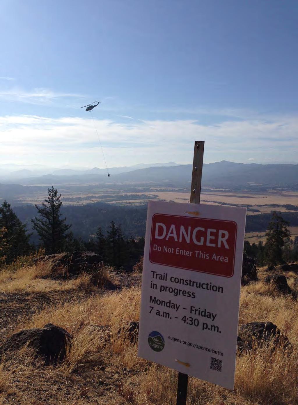
1 PUBLIC WORKS PROJECT OF THE YEAR NOMINATION FORM SUBMITTAL DEADLINE: Monday, August 31, 2015 PROJECT INFORMATION Spencer Butte Summit Trail July 30, 2015 Project Name Project Completion Date* City of Eugene Public Agency PROJECT CATEGORY (select one): PROJECT DIVISION (select one): Structures Less than $5 million Transportation $5 million to less than $25 million Environmental (Water, Wastewater, Stormwater) $25 million to $75 million Historical Restoration/Preservation More than $75 million Disaster or Emergency Construction/Repair *Must be substantially complete and available for public use within two calendar years prior to nomination. MANAGING AGENCY Adam Steffen Landscape Architect Name Title City of Eugene Agency/Organization 99 East Broadway, Suite 400 Address (if post office box, include street address) Eugene Oregon City State Zip (541) (541) Phone Fax PRIMARY CONTRACTOR Bruce Maederer Vice President Name Title Oregon Woods, Inc. Agency/Organization PO Box Address (if post office box, include street address) Eugene Oregon City State Zip (541) (541) Phone Fax
 Name Agency/Organization Address (if post office box, include street address) City State Zip Email Phone Fax SUBMIT APPLICATION PACKET TO: N/A 2758 3rd St Pulc Wos Poect o te")
2 Larry Wilson Name PRIMARY CONSULTANT Agency/Organization Address (if post office box, include street address) City State Zip Phone Fax NOMINATED BY (only managing public agency or APWA Chapters eligible to nominate) Name Agency/Organization Address (if post office box, include street address) City State Zip Phone Fax SUBMIT APPLICATION PACKET TO: N/A rd St Pulc Wos Poect o te Yea Aads Poga City of Oregon City ATTN: Jon Leis, P.E. P.O. Box Center Street Oregon City, OR leisorcity.org Trail Engineer Springfield Oregon llwcorp@comcast.net (541) Matt Rodrigues City of Eugene 99 East Broadway, Suite 400 NOTE: Supporting documentation is liited to tenty (20) ages, exclusive of photographs (10 to 20 photos of the project including a few "before" photos if possible) and the nomination form. Tis suittal ill not e returned. Please submit your application by the deadline identified at the top of this application by both of the following methods: Title Principal Civil Engineer Eugene Oregon matt.j.rodrigues@ci.eugene.or.us (541) (541) Title Eail Send by a digital copy of the nomination form and supporting documentation. If possible, include 10 to 20 photographs of the project which can be sent, if necessary, by more than one . Hard Coy Hand deliver or send by US mail (postmarked by due date) or delivery service one "hard" copy of the nomination form and supporting documentation. Include a USB flash drive (or CD) with 10 to 20 photographs of the project along with a digital copy of the nomination form and supporting documentation.
3 SUBMITTAL GUIDELINES Public Works Project of the Year PLEASE ADDRESS EACH OF THE FOLLOWING AREAS IN YOUR SUPPORTING DOCUMENTATION ADHERING TO THE BELOW SEQUENCE WHEN POSSIBLE. General description of the project. Completion date contained in contract. Any time extensions granted should be addressed in the submittal. Construction schedule, management, and control techniques used. Safety performance including number of lost-time injuries per 1,000 man hours worked and overall safety program employed during the construction phase. Community need a summary of how the project met the community needs as related to economic challenges, value engineering, creative use of resources, to the measurable benefit to the community. Sustainable practices use of alternative materials, practices, or funding that demonstrates a commitment to sustainability. Environmental considerations including special steps taken to preserve and protect the environment, endangered species, etc., during the construction phase. Community relations a summary of the efforts by the agency, consultant and contractor to protect public lives and property, minimize public inconvenience and improve relations. Unusual accomplishments under adverse conditions, including but not limited to, adverse weather, soil or site conditions, or other occurrences over which there was no control. Additional considerations you would like to bring to the attention of the project review panel such as innovations in technology and/or management applications during the project. Include a description of special aspects of the project. NOTE: Supporting documentation is liited to tenty (20) ages, exclusive of photographs (10 to 20 photos of the project including a few "before" photos if possible) and the nomination form. This subittal ill not be returned. Please submit your application by the deadline identified at the top of this application by both of the following methods: Eail Send by a digital copy of the nomination form and supporting documentation. If possible, include 10 to 20 photographs of the project which can be sent, if necessary, by more than one . Hard Coy Hand deliver or send by US mail (postmarked by due date) or delivery service one "hard" copy of the nomination form and supporting documentation. Include a USB flash drive (or CD) with 10 to 20 photographs of the project along with a digital copy of the nomination form and supporting documentation.
4 Spencer Butte Summit Trail, Eugene, Oregon General Project Description The Spencer Butte summit is the highest point along Eugene s popular ridgeline open space system at 2,054 feet and has been a popular destination for generations of hikers. In recent years, as many as 300 visitors per day make the trek to the summit to enjoy unobstructed views of the valley below, almost all using the Main Summit Trail, which traverses the south side of the butte prior to approaching the summit from the east above the tree line. The City of Eugene, along with a dedicated group of volunteers, has made substantial improvements to the lower portion of the trail during the past twelve years. The Spencer Butte Summit Trail project on the upper portion of this trail was the final, and most critical, piece of the broader strategy to improve the entire length of the Main Summit Trail. The rocky open area found on and around the summit is an extremely unique habitat within the Willamette Valley and contains a diverse mixed community of grasses and forbs, ferns, lichens and bryophytes. The continuous heavy use, combined with a poorly defined trail alignment, has resulted in significant issues related to route-finding, user safety, erosion, trail braiding, and habitat degradation over a wide expanse of the sensitive summit area. The objectives of the proposed $400,000 project on the upper reach of the Main Summit Trail were as follows: Improve Accessibility: The Spencer Butte trail is a free public resource, easily accessed from the Eugene-Springfield Metro Area and adjacent communities. Trail improvements enhanced accessibility to the summit area for a broader range of users including the elderly, children and those with mobility issues. Improve User Safety: Before the project the Main Summit Trail could be hazardous to less skilled hikers and numerous user injuries occurred annually. Lack of route clarity near the summit had resulted in trail users becoming lost and inadvertently descending on steep slopes with hazardous drop-offs, often requiring emergency response (5-10 responses per year). Restore and Protect Habitat: The rocky open area found on and around the summit is a unique habitat within the Willamette Valley and contains a diverse community of grasses, forbs, ferns, lichens and bryophytes. Heavy and widely dispersed use was significantly degrading this sensitive rare habitat. Provide an Outstanding Recreational Resource: The Spencer Butte Summit Trail is a treasured recreational resource and the project was constructed to be worthy of its National Recreation Trail designation. Through an extensive public process conducted between October and December 2010, a preferred option for the re-alignment and restoration of the upper portion of the Main Summit Trail was selected and a detailed design was developed with consultants. The project included: Page 1
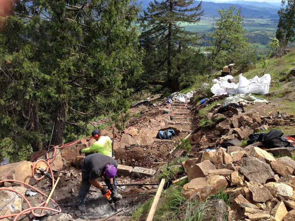
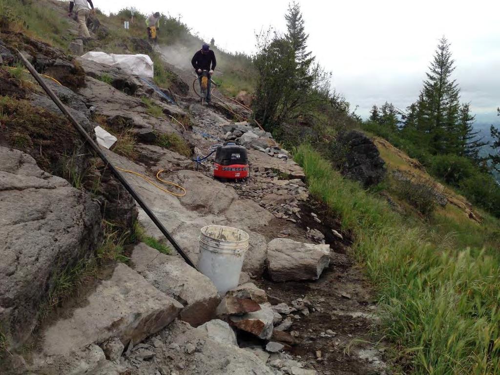
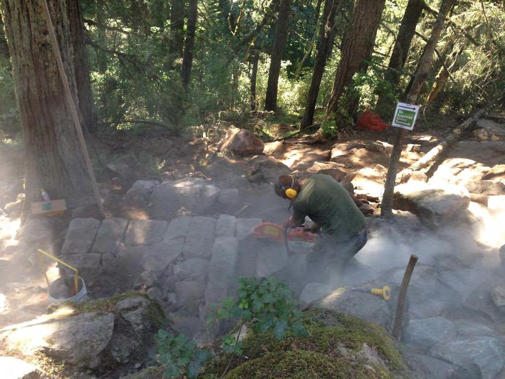
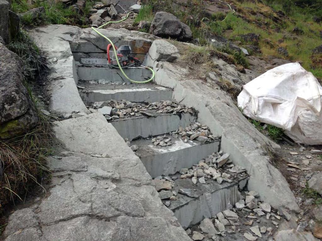
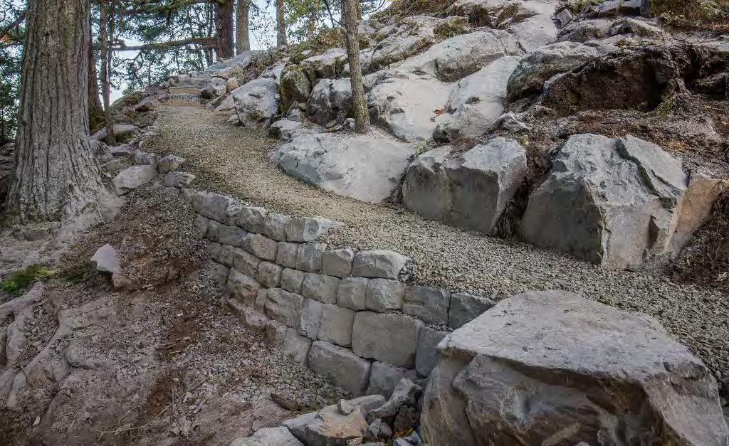
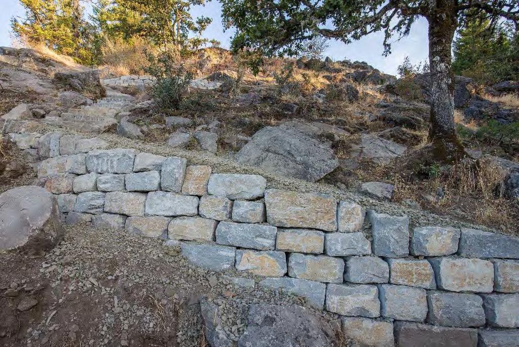
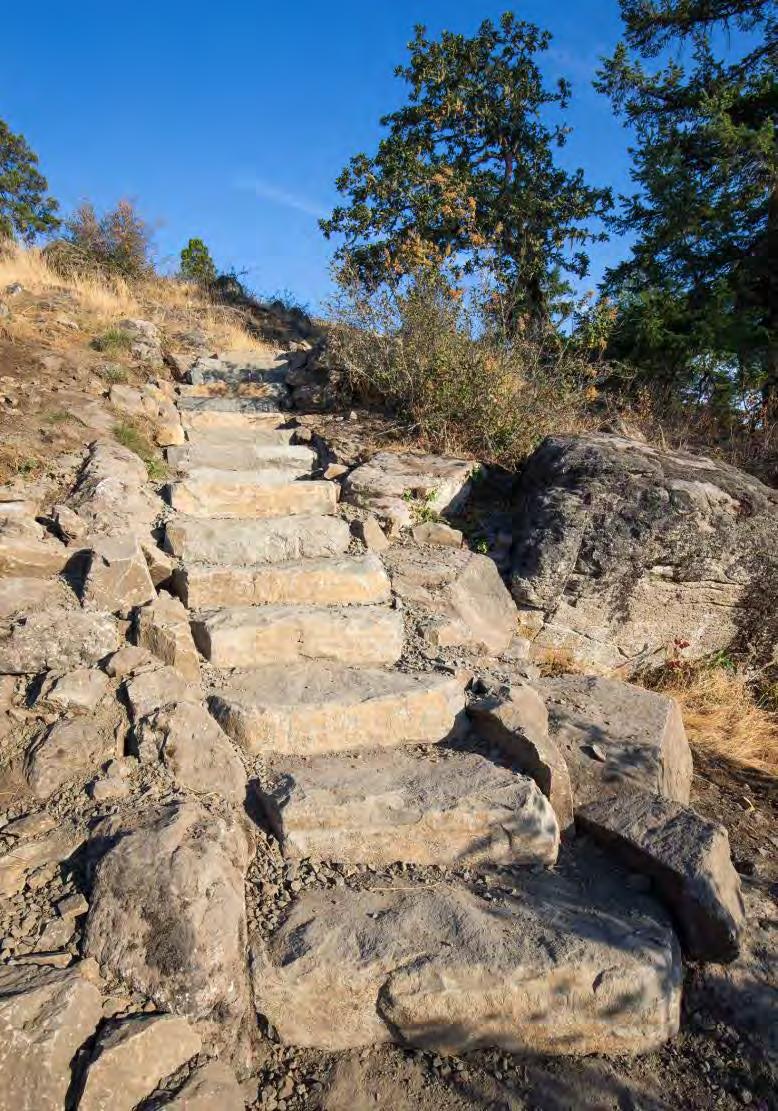
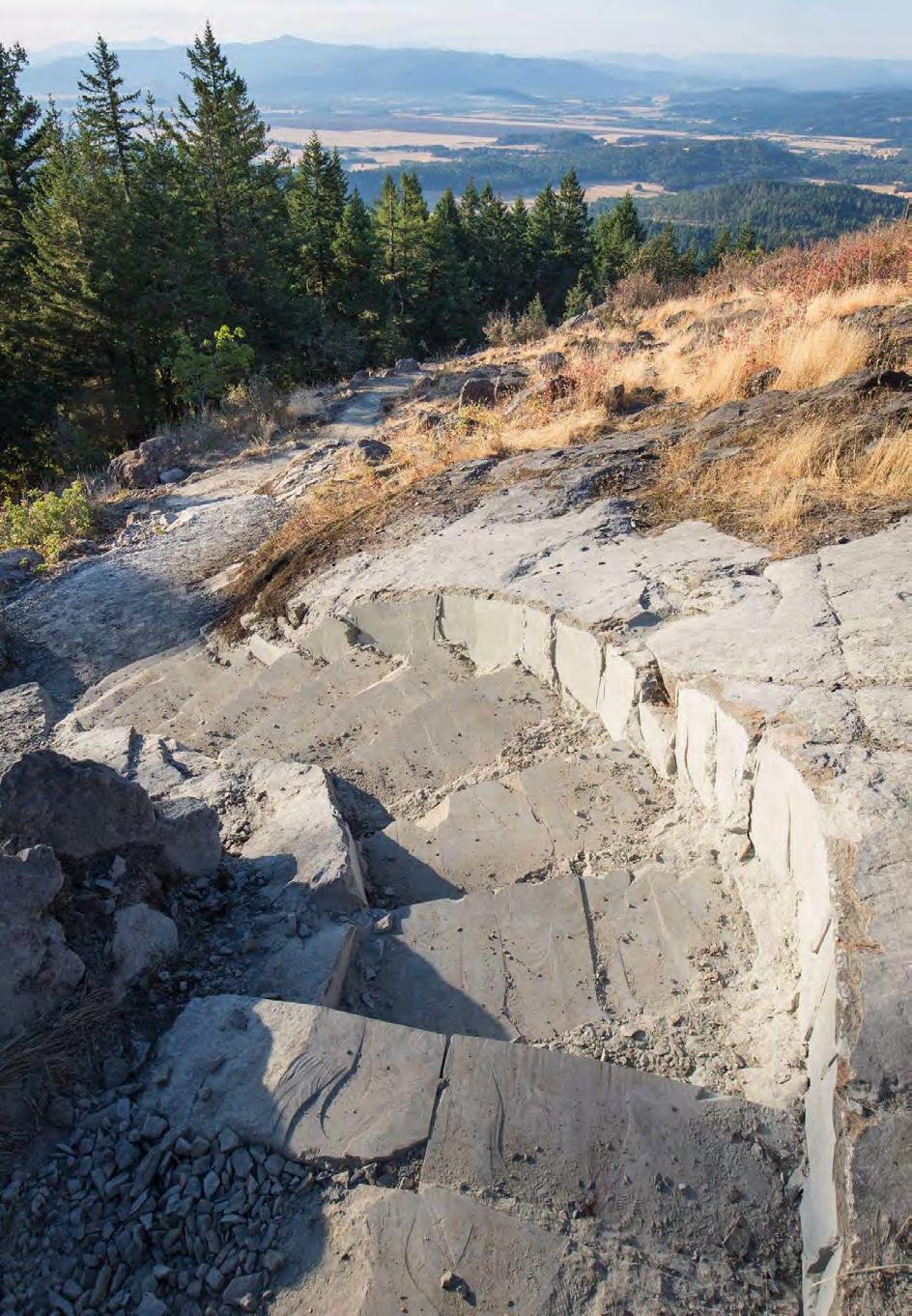
5 Reconstruction of approximately 344 feet of degraded trail below tree line to bring the trail up to standards; Construction of 687 lineal feet of new trail around a steep and eroded section of existing trail in a location with a stable bedrock surface with improved views to the south and east; Reconstruction of an additional 428 lineal feet of existing trail in the summit area; and Removal (obliteration) and re-vegetation of the abandoned segment and multiple nearby trail braids over an area of approximately 2.3 acres with native species endemic to this unique habitat. Stone retaining walls and steps were built along portions of the route and much of the trail surface was graveled to improve tread. The trail design was based on a combination of the USDA Forest Service, Region 6, U.S. Customary Specifications for Construction and Maintenance of Trails, Pacific Northwest Region and the City of Eugene Parks and Open Space Division s Trail Maintenance Program Guidelines. The design approach was intended to maximize aesthetics, route clarity, resource protection, sustainability and improved accessibility and user safety. The trail design greatly reduced the need for signage, trail markers and fencing. Since the new trail has opened it is now visited daily by dozens if not hundreds of users, including children, teenagers, adults, parents, families and senior citizens. The new trail has allowed a wider range of users, particularly young children or older visitors with mobility issues, to reach the summit of the butte. The new trail has facilitated a significant resurgence and increase of visitation use while protecting the rare and sensitive vegetation and habitat present in the summit area. Visitors have been overwhelmingly positive in their comments and appreciation of the new trail alignment, the clearly identifiable route, and the improved accessibility the trail has provided to reach the summit of a local landmark. Project Completion Date The project was bid on January 27, 2015 with a required completion date of July 31, The contractor, Oregon Woods Inc., started onsite work April 1, 2015 and completed their work, including a majority of punch list items, by July 30, No time extensions were requested or required on the project. Revegetation work, including seeding and planting, was not included in the construction contract and will be undertaken in fall of 2015 by City staff and volunteers. Project Construction Scheduling, Management, and Control Techniques The contractor was required to submit schedule updates throughout the project. Due to the narrow and very linear nature of the project each work area frequently hop scotched as one area of work was completed and materials or equipment needed for the next adjacent section were not available yet or were being utilized in other areas. Each individual work zone and associated type of work often only allowed for one worker at each location for logistical and Page 2
6 safety reasons. This often led to quickly changing work schedules and modifications to the proposed schedule, requiring flexibility on the part of the Contractor and the City. Additionally the bid and contract documents were carefully written to ensure only qualified trailspecific contractors would be eligible for the project. Both general experience requirements and additional qualification documentation for a number of work categories was required to be submitted with bid materials. This included reference projects for various components of the work involved with the Spencer Butte project with accompanying photographic evidence of the work. This qualification information was then verified and reference checked for the contractor as part of the bid award process. This vetting step helped ensure project success. Project Safety Performance No time-loss injuries occurred during the project. The contractor employed traditional safety requirements during the construction, including use of appropriate eye and ear protection, respiratory masks during the extensive stone cutting and removal work, use of blast mats during micro-blasting work, and mandatory hard-hats and brightly colored safety vests or clothing during aerial lift days. One unique safety concern encountered during the project was the presence of Western rattlesnakes. Typically rarely seen, numerous snakes were observed and encountered during the project. In a few instances rattlesnakes took up refuge in rock pockets in the work zone, requiring workers to flag the location to prevent accidental encounters until the snake moved on. In addition, a herpetologist from the University of Oregon was engaged at one point to capture and safely relocate a snake that remained present for a period of time, delaying work in one trail section. Community Need The Spencer Butte Summit Trail project fulfilled a number of community needs, based both on long-range planning documents, community values and resource conservation. Numerous City planning documents have identified protecting and enhancing Spencer Butte and the entire Ridgeline trail system, including: City of Eugene Parks, Recreation and Open Space Project and Priority Plan (2006): The PROS Project and Priority Plan was adopted by the Eugene City Council and is a refinement of the Metro Plan. Enhancement of the Spencer Butte Trail System is listed as a high priority action. Ridgeline Open Space Vision and Action Plan (LCOG, 2008): This plan, which was endorsed by The Eugene and Springfield City Councils and the Lane County Board of Commissioners, identifies numerous goals related to expanding and maintaining the Ridgeline Trail System, improving accessibility to key features such as Spencer Butte, providing access to a broad group of users, and the conservation and preservation or rare and unique habitats. Page 3
7 Spencer Butte Management Plan (Draft, December 2010): The draft Management Plan provides detailed direction for addressing issues associated with heavy recreational use, invasive species and management of rare habitat types on Spencer Butte. The draft plan proposes improved protection and restoration of the summit habitat, the reconstruction and rerouting of the Main Summit Trail, and improved user safety and accessibility. Situated immediately adjacent to the UGB, the Main Summit Trail is the most heavily used segment of the Ridgeline Trail network, which currently extends for approximately nine miles along the southern edge of Eugene, including several connector trails from nearby neighborhoods and parks. In addition the Ridgeline Trail, of which Spencer Butte is a component, was designated a National Recreation Trail by the US Department of the Interior in June of This designation exemplified that the Ridgeline trail system as an excellent example of the Four C s (conservation through communication, consultation and cooperation) that are guiding principles of the Interiors Department s approach to natural resource stewardship. The existing Main Summit Trail was experiencing significant issues related to route-finding, user safety, erosion, trail braiding and habitat degradation and was badly in need of rehabilitation and reconstruction. Recent attempts to clarify the trail route and consolidate use through placement of trail markers and fencing had very limited success. This issue became a self-perpetuating problem, with even the most well intentioned hikers reporting difficulty following the designated trail route, and the network of unofficial trails and trail braids continued to grow. Issues associated with user safety, especially to less skilled hikers, had also been a worsening problem. Lack of route clarity near the summit resulted in trail users becoming lost on a frequent basis, often inadvertently descending on steep slopes with hazardous drop-offs. Safety is also an ongoing problem on the steeper portions of the designated trail, where slipping and falls are common due to loss of footing on wet rock inclines, mud, or loose soil. Lane County Search and Rescue responds to reports of lost or injured hikers on Spencer Butte between five and ten times per year. A public process guided the development of the City of Eugene's Parks, Recreation, and Open Space Comprehensive Plan (2006) and PROS Project and Priority Plan (2006), which proposes improvements to the Spencer Butte Trail System. Over 3,000 people participated in the plan s development which listed the rehabilitation of the Spencer Butte trail system as the highest priority category based on this input. To solicit input specific to the proposed project, the City conducted an extensive public involvement process between October and December This included two public meeting attended by 70 participants, an online survey completed by 153 individuals, and a half-day mobile workshop held on the summit of the butte with approximately 50 participants. The proposed project was one of five alternatives considered and received the highest level of support by a significant margin. The Main Summit Trail project received enthusiastic support from trail users, a variety of interest groups, and local governments. As part of the funding identification for the project the City applied for an Oregon Parks and Recreation Department (OPRD) 2012 Non-Motorized Page 4
8 Recreational Trails Program (RTP) grant as funded by the Federal Highway Administration (FHWA). Letters of support from the following broad range of organizations were received as part of the grant application: Lane County Audubon Society Eugene Springfield Fire and Emergency Medical Services Eugene Mountain Rescue, Inc. Eugene Parks Foundation Lane Council of Governments North American Butterfly Association, Eugene-Springfield Chapter Native Plant Society of Oregon, Emerald Chapter Obsidians, Inc. (Eugene-based outdoor organization) Lane County Sheriff s Office, Search and Rescue The outcome of the grant application ranked the Spencer Butte Summit Trail project first out of 35 projects applying for available funding. Due to its location and local prominence Spencer Butte and the Main Summit Trail are easily accessible from the Eugene-Springfield Metro Area and adjacent communities, offering a free resource to the public. The trail improvements enhance accessibility to the summit area for a wider range of users including the elderly, children and those with mobility issues. Improved accessibility also provides expanded opportunities for user groups such as the Obsidians, trail runners, nature appreciation organizations such as Lane County Audubon, the North American Butterfly Association, the Native Plant Society and students from nearby schools. Additionally, the City s Recreation Program offers a variety of planned hikes to Spencer Butte annually, many of which emphasize the youth and retired community who benefit from the new trail enhancements. An outstanding destination such as the Spencer Butte Summit provides great incentive for physical activity and exercise for residents of our community. In addition Spencer Butte draws recreational users and visitors from outside of our community and is important from a tourism standpoint. Sustainable Practices The Spencer Butte Summit Trail project constructed a trail that is solid and sustainable, and that will serve as a legacy for generations to come. The Main Summit Trail design standards were derived from a combination of the USDA Forest Service, Region 6, U.S. Customary Specifications for Construction and Maintenance of Trails, Pacific Northwest Region and the City of Eugene Parks and Open Space Division s Trail Maintenance Program Guidelines. Because the trail traverses rugged terrain and passes through highly sensitive habitat, special attention was given to siting the trail in a way that takes advantage of natural topography and location of solid bedrock outcrops, while avoiding areas of existing high quality habitat. The completed trail is obvious and easy to follow, while also blending gracefully into the open summit landscape. The route takes advantages of natural steps and rises within bedrock and utilizes native materials (native basalt rock and gravel) in the construction of retaining walls and Page 5
9 surfacing in the highly visible area above the tree line. This approach produced a very durable and low maintenance facility that is clear and easy to follow, eliminating need for trail markers, signs, or fencing. The design criteria developed for the trail included special considerations for accommodating the heavy all-season use this trail receives. The trail is constructed with a steeper than average running grade (15-20%) along with steps to maintain some challenge while also working to facilitate social sustainability of the trail (i.e. the balance between constructed physical sustainability and social desire lines to reach a destination, the summit in this case). Major switchbacks were intentionally avoided in siting the trail in order to discourage shortcutting and off-trail use. The minimum trail width is 3 feet with wider zones constructed to facilitate passing, particularly above and below step sections, as well as larger areas for resting and viewing. All trail segments that are not located on bed rock were surfaced with crushed basalt aggregate to facilitate durable all season use. A trail cross slope (3-5%), rolling grade dips, and durable rock check dams were incorporated into the trail to facilitate adequate drainage and retentions of surfacing material. Additionally very wet area uncovered during construction was modified to be constructed with heavy-duty rock flagstone construction to provide a durable trail section. The abandoned trail segment and nearby trail braids have been obliterated and will be re-vegetated over an area of approximately 2.3 acres. Environmental Considerations One of the key out-come based goals of the trail project was to facilitate protection of the rare and unique habitat present in the rocky summit area of the butte. Continuous heavy use, combined with a poorly defined trail alignment, resulted in significant issues related to routefinding, user safety, erosion, trail braiding and significant habitat degradation on the open rocky summit of Spencer Butte. According to a UO recreational impact study conducted in 2002, the vast majority of users surveyed were unaware that the summit is home to a rare plant community, many noted the confusing trail route near the summit, and when asked if they would be willing to stay on a designated trail if it were improved, 99% responded yes. As part of the RTP grant application two thorough botanical surveys were conducted during the growing season of 2011 along a 20 wide trail corridor to document significant native plant species. The surveys conducted that habitats on Spencer Butte are locally significant because they contain open, rocky habitats and have a relatively high elevation yet are close to the Valley floor. Some plant species observed had not previously been recorded on the Butte and others had not been recorded since the 1930 s. No listed rare plant species were recorded, however a number of uncommon species were observed. Due to the presence of unique and uncommon plant species above the butte tree line the contractor was not allowed to sidecast common excavation material, including rock. All material excavated to create the trail bench was required to be incorporated in the new work, transported to the old trail to be obliterated, or transported below tree line and disposed of in agreed upon locations. In addition the contractor was required to cover all exposed soils at the completion of the project with native straw that was aerial transported into the site. This Page 6
10 temporary measure was required as part of a narrative erosion control plan, in addition to typical protection measures at staging areas, such as use of bio-bags to protect inlets, etc. To protect and further enhance the rare plant populations present on the butte, City staff along with volunteers salvaged plant material that was directly along the trail alignment prior to the project. In addition genetically local native seed of species endemic to the Spencer Butte Summit area were collected for propagation and future replanting. This material has been stored and propagated at the City s native plant nursery. In follow up to the construction project City staff along with volunteers will revegetate the new trail corridor, the old obliterated trail corridor and other informal user trails in the fall of 2015 with native seed and plantings along with native lichen, moss and other bryophyte species. Community Relations Managing public access to the popular butte while facilitating the project work was a key issue identified early on in the project planning. Unlike typical projects where users are in vehicles or on bicycles on a constrained road or paved trail. 100% of visitors to the butte are on foot, which required additional consideration in traffic control planning. In order to alleviate some access pressure, the summit area of the butte remained open and accessible from the alternative steeper West Summit Trail for the project duration, with the exception of aerial lift days. This allowed the public to continue accessing the summit destination while facilitating the project work. During the work days between 7:00 am and 4:30 pm the upper portion of the Main Summit Trail was closed to public access. The bottom of the existing trail section was closed with a signed fence and gate system that was closed and opened each day by the contractor. Visitors to the summit via the West Summit Trail encounter a porous border that was staked and signed at approximately 100 intervals with closure notifications. In addition, project specific traffic control signs were installed at key locations, requiring visitors to Stay On Trail to help prevent off-trail access, and a Summit Trail Closed Ahead placed at the main bottom access point to the trail adjacent to information signage created about the project. The majority of construction equipment and materials were required to be aerially lifted to the project site to prevent damage to the existing sections of trail below the project. This required closing the entire 300 acre park and the adjacent section of Ridgeline hiking trail to provide a safe fly and lifting zone. This required extensive coordination between the contractor, City staff, and private security staff hired to monitor the closure points at trailheads. Public notice via a projectspecific website, an agency Twitter account, the local newspaper, and updated trailhead signage were issued to identify fly days and time when the park would be closed. All major access points were actively staffed and monitored during fly days to ensure public safety was maintained while facilitating timely lifting work. No significant issues or unanticipated visitor encounters occurred due to the extensive outreach and monitoring work. Unusual Accomplishments & Special Conditions Page 7
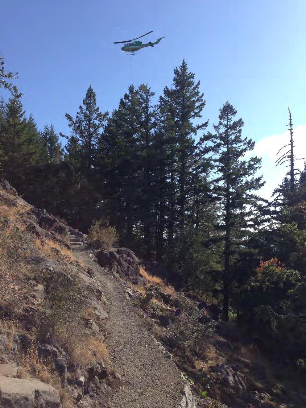
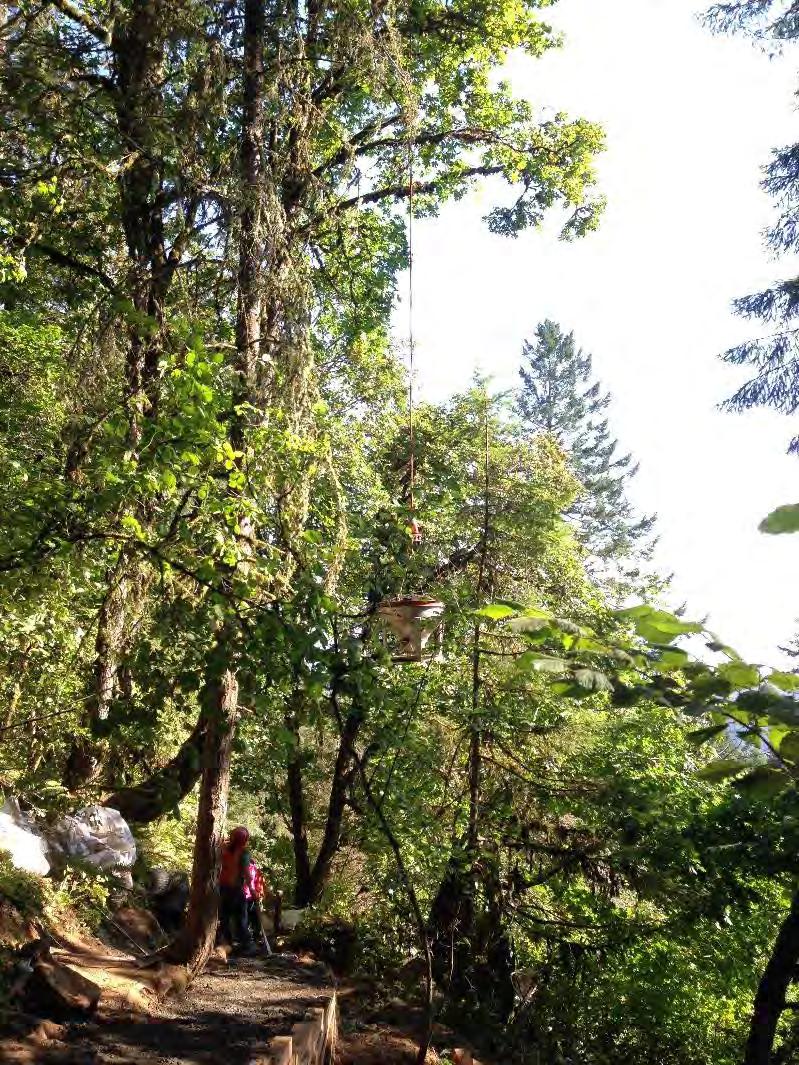
11 The construction requirement, techniques, and complexity necessary to build this trail were highly unique for the local area and even regionally. There are very few examples of similar trail construction techniques regionally. Many examples of similar steps and construction challenges were built in the Civilian Conservation Corp era, and typically are found in National Parks or on the East coast, which has a long history of stonework craftsmanship involved with trail construction. The project was essentially a front country urban accessible trail that was built with back country challenges and conditions. Although the project was somewhat small based on length, the access constraints, trail grade, and construction techniques involved across bedrock were highly unique and challenging in nature. Much of the construction occurred above treeline in areas with shallow topsoil and exposed bedrock. Use of a range of techniques was needed to carefully excavate a trail into bedrock. In addition, both imported steps and bedrock steps were constructed, both of which were challenging and required investigation, trial-and-error, and flexibility by the contractor and City to produce and obtain the required outcomes based on varying onsite conditions. Extensive use of aerial lifting was unique to the project. As protection of the below-treeline trail was identified as a project goal, and the pure logistics of moving the necessary construction equipment and tons of rock needed to the summit of the butte, use of helicopters were necessary every one to two weeks during the four month project. This required extensive planning and coordination by the City and Contractor to identify an adjacent aerial staging location that met access and safety requirements, negotiate and obtain land owner approval for temporary use, and ensure the public was protected throughout the aerial lifting work. Additional Considerations Since the project s completion on July 31, 2015 the new trail has been used by literally thousands of visitors. While the City does not have specific counts anecdotal observations indicate visitor counts have substantially increased, both for local residents and new visitors to the area. Many trail users, particularly older users with mobility challenges, have also indicated that the new trail has allowed them to return to visiting the butte summit when the former scramble trail had previously prevented their visits from continuing. Feedback on site and through local media has been resoundingly positive from the trail users. Based on the considerations listed above, we believe the trail design and construction not only met the intent and goals of the overall project, but exceeded the expectations and will be well utilized and appreciated by current and future generations of trail users. Page 8


12 Spencer Butte - A Popular Destination Spencer Butte summit, ca Source: University of Oregon The Spencer Butte summit is the highest point along Eugene s ridgeline park system at 2,065 feet and has been a popular destination for generations of hikers. In recent years, as many as 300 visitors per day visit the summit to enjoy unobstructed views, almost all using the Main Summit Trail.


13 Spencer Butte - Unique and Sensitive Habitat The rocky open area found on and around the summit is an extremely unique habitat within the Willamette Valley and contains a diverse mixed community of grasses and forbs, ferns, lichens, and bryophytes. This habitat is favored by wildlife species such as the Western Rattlesnake and California Ground Squirrel.


14 Pre-Project Conditions at the Spencer Butte Summit The continuous heavy use, combined with a poorly defined trail alignment resulted in significant issues related to route-finding, user safety, erosion, trail braiding, and habitat degradation over a wide expanse of the sensitive summit area.


15 Spencer Butte Main Summit Trail - Recent Improvements Over the past decade, the City of Eugene, along with the help of numerous dedicated volunteers, has made significant progress toward improving the lower portion of the Main Summit Trail at Spencer Butte. The summit trail project is the final component of a strategy to improve the entire trail length from the main parking area to the summit. Approximately 90 percent of the visitors use this route to reach the summit Trail Reconstruction 2009 Trail Re-route 2008 Trail Improvement 2009 Trail Re-route 2010 Trail Reconstruction 2009 Volunteer Trail Project


16 Developing a Design Solutions The design objectives of the project were to maximize aesthetics, route clarity, resource protection, and sustainability; to improved accessibility and safety; and to repair and protect sensitive habitat. A number of case studies were used to help establish a high quality design. Existing trail segment identified for reconstruction Proposed trail alignment Yosemite National Park Glacier National Park Lassen National Park Rogue River Trail


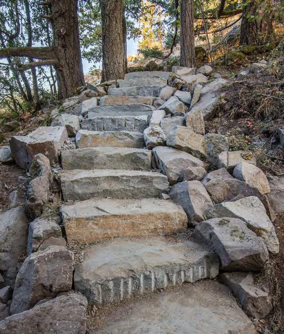
17 Upper Spencer Butte Trail Construction In 2015, the uppermost 1,500 feet of the popular Spencer Butte trail was reconstructed to create a clear and safe route to the summit. The new trail was designed to blend into the aesthetic of the Butte and included construction of a stable trail bed and installation of over 100 rock steps through placement of imported basalt or cutting steps into bedrock. The abandoned trail route and braids will be revegetated this fall. Imported Basalt Steps in Steep Rocky Section Cutting Steps into Bedrock Retaining Wall Fencing on Switchback Completed Steps Cut from Bedrock


18 The New Spencer Butte Summit Trail In Use Construction of the Main Summit Trail was completed and opened to increased public use in late July 2015, receiving overwhelming positive response from visitors of all ages. Letter to the Editor The Register Guard Eugene, Oregon August 30, 2015
19
20
21
22


23 AFTER BEFORE
24


25 AFTER BEFORE
26
ROAD AND TRAIL PROJECT APPROVAL
 ROAD AND TRAIL PROJECT APPROVAL www.marincountyparks.org Marin County Parks, 3501 Civic Center Dr, Suite 260, San Rafael, CA 94903 DATE: July 12, 2017 PRESERVE: Gary Giacomini Open Space Preserve PROJECT:
BACKCOUNTRY TRAIL FLOOD REHABILITATION PROGRAM
 BACKCOUNTRY TRAIL FLOOD REHABILITATION PROGRAM Backcountry Trail Flood Rehabilitation A June 2013 Flood Recovery Program Summary In June 2013, parts of Southern Alberta were devastated from significant
Bear Creek Habitat Improvement Project
 06/10/10 Bear Creek Habitat Improvement Project El Paso County, Colorado Pike National Forest and Colorado Springs Utilities Owned Land Report prepared by: Eric Billmeyer Executive Director Rocky Mountain
Bradley Brook Relocation Project. Scoping Notice. Saco Ranger District. United States Department of Agriculture Forest Service
 Bradley Brook Relocation Project United States Department of Agriculture Forest Service Scoping Notice White Mountain National Forest February 2011 For Information Contact: Jenny Burnett White Mountain
City of Durango 5.8 FUNDING TRAILS DEVELOPMENT
 5.8 FUNDING TRAILS DEVELOPMENT The City has been successful in establishing dedicated local funding sources as well as applying for grants to develop the City s trail system, having received nearly $2.4
Logo Department Name Agency Organization Organization Address Information 5700 North Sabino Canyon Road
 Logo Department Name Agency Organization Organization Address Information United States Forest Coronado National Forest 5700 North Sabino Canyon Road Department of Service Santa Catalina Ranger District
Kit Carson-Challenger Ridge Trail Project
 Kit Carson-Challenger Ridge Trail Project Project Accomplishments Report-USFS December 15, 2015 Photo courtesy of Justin Peterson 815 South 25 th Street, Suite 101 Colorado Springs, CO 80904 Dedicated
APPENDIX D: SUSTAINABLE TRAIL DESIGN. APPENDICES Town of Chili Parks and Recreation Master Plan Update
 APPENDIX D: SUSTAINABLE TRAIL DESIGN APPENDICES Town of Chili Parks and Recreation Master Plan Update Sustainable Trail Construction Sustainable trails are defined by the US Forest Service as trails having
EXECUTIVE SUMMARY PROGRAM DEVELOPMENT REPORT PURPOSE EXISTING SETTING EXPANDING PARKLAND
 EXECUTIVE SUMMARY PROGRAM DEVELOPMENT REPORT PURPOSE As the culmination of the first phase of the master planning process, this Program Development Report creates the framework to develop the Calero County
Continental Divide National Scenic Trail Legislative History and Planning Guidance
 Continental Divide National Scenic Trail Legislative History and Planning Guidance Legislation, Policy, and Direction Regarding National Scenic Trails The National Trails System Act, P.L. 90-543, was passed
The Whitefish Trail
 The Trail - 2017 Trail Construction Specifications & Scope of Services The Lower Haskill section of Trail construction will take place on two different land ownerships: City of and Iron Horse. This section
Kit Carson-Challenger Ridge Trail Project Annual Performance Report-2014 October 22, 2014
 1 Kit Carson-Challenger Ridge Trail Project Annual Performance Report-2014 October 22, 2014 Willow Lake and Kit Carson Peak 2 SUMMARY The Rocky Mountain Field Institute began Phase 1 of a multi-phase,
Cultural Resource Management Report Deer Valley 4wd Restoration and Blue Lakes Road Maintenance Project R
 Cultural Resource Management Report R2015-05-03-10005 Undertaking Description: The proposes to perform road maintenance and meadow restoration on the Deer Valley 4wd trail and road maintenance on the Blue
Trail Assessment Report
 Trail Assessment Report Trail Options for the Bear Creek Canyon located in Pikes Peak Ranger District, Pike National Forest and on Colorado Springs Utility Lands Due to the presence of a unique species
Trail Phasing Plan. Note: Trails in the Clear Creek Canyon area (Segments will be finalized in the future to minimize wildlife impacts
 Note: Trails in the Clear Creek Canyon area (Segments 2 5 and a future JCOS connection) will be finalized in the future to minimize wildlife impacts Trail Phasing Plan P Parking 3 Easy Trail Intermediate
Peter Axelson. Beneficial Designs, Inc. Minden, NV
 Peter Axelson Beneficial Designs, Inc. Minden, NV Arroya Sit Ski Mono Ski Dynamic Seating Spring Assist Cross Country Ski Hand Bike Adaptive Canoe Seating Available from Chosen Valley Canoe Accessories
Wilderness Research. in Alaska s National Parks. Scientists: Heading to the Alaska Wilderness? Introduction
 Wilderness Research in Alaska s National Parks National Park Service U.S. Department of Interior Scientists: Heading to the Alaska Wilderness? Archeologist conducts fieldwork in Gates of the Arctic National
Appendix C. Tenderfoot Mountain Trail System. Road and Trail Rehabilitation Plan
 Appendix C Tenderfoot Mountain Trail System Road and Trail Rehabilitation Plan All rehabilitation work would be under the direction of the District Fisheries Biologist, the Forest Hydrologist, and/or the
FEASIBILITY CRITERIA
 This chapter describes the methodology and criteria used to evaluate the feasibility of developing trails throughout the study areas. Land availability, habitat sensitivity, roadway crossings and on-street
Appendix A Appendix A (Project Specifications) Auk Auk / Black Diamond (Trail 44) Reroute
 Auk Auk / Black Diamond (Trail 44) Reroute") Appendix A (Project Specifications) Auk Auk / Black Diamond (Trail 44) Reroute I. Proposed Action: This project proposes to reroute approximately 1,800 feet of a 50 inch wide trail, off of private property
Appendix A (Project Specifications) Auk Auk / Black Diamond (Trail 44) Reroute I. Proposed Action: This project proposes to reroute approximately 1,800 feet of a 50 inch wide trail, off of private property
DATE: 23 March, 2011 TO: Communities FROM: BlazeSports America. RE: Accessible Trails Checklist 1
 M E M O R A N D U M DATE: 23 March, 2011 TO: Communities FROM: BlazeSports America RE: Accessible Trails Checklist 1 The purpose of the Accessible Trails Checklist (below) is to help the community review
Chapter 6: POLICY AND PROCEDURE RECOMMENDATIONS
 Chapter 6 POLICY AND PROCEDURE RECOMMENDATIONS FOR SRRA Below are seven policy elements that should be considered for adoption by the Southwest Regional Recreation Authority of Virginia: 1. Develop strategies
RE: Access Fund Comments on Yosemite National Park Wilderness Stewardship Plan, Preliminary Ideas and Concepts
 September 30, 2016 Superintendent Yosemite National Park Attn: Wilderness Stewardship Plan P.O. Box 577 Yosemite, CA 95389 RE: Access Fund Comments on Yosemite National Park Wilderness Stewardship Plan,
Tallahassee-St. Marks Historic Railroad Trail
 Revitalizing a Historic Trail Designated as a National Recreation Trail, the 16-mile Tallahassee-St. Marks Historic Railroad Trail has been enjoyed by countless bicyclists, runners, and outdoor enthusiasts
DECISION MEMO. Rawhide Trail #7073 Maintenance and Reconstruction
 Page 1 of 6 Background DECISION MEMO USDA Forest Service Jefferson Ranger District Jefferson County, Montana Rawhide Trail #7073 is located in the Elkhorn Mountain Range approximately 10 miles east of
Mt. Hood National Forest
 United States Department of Agriculture Forest Service Mt. Hood National Forest Zigzag Ranger District 70220 E. Highway 26 Zigzag, OR 97049 503-622-3191 Fax: 503-622-5622 File Code: 1950-1 Date: June 29,
Understanding user expectations And planning for long term sustainability 1
 Understanding user expectations And planning for long term sustainability 1 What is a natural surface trail? It can be as simple has a mineral soil, mulched or graveled pathway, or as developed as elevated
COASTAL CONSERVANCY. Staff Recommendation December 2, 2004 COYOTE HELLYER COUNTY PARK BAY AREA RIDGE TRAIL
 COASTAL CONSERVANCY Staff Recommendation December 2, 2004 COYOTE HELLYER COUNTY PARK BAY AREA RIDGE TRAIL File No. 04-057 Project Manager: Amy Hutzel RECOMMENDED ACTION: Authorization to disburse up to
2. STAKEHOLDER FEEDBACK // What We Heard
 1. QUARRY ROAD TRAIL // Welcome to the Information Session PROJECT DESCRIPTION WHY WE ARE HERE Quarry Road Trail is a popular commuter trail and recreational area for Calgarians. 1. To report citizen feedback
Port Gamble Shoreline Area Conceptual Trail Proposal
 The North Kitsap Trails Association is pleased to be a partner to the Kitsap Forest and Bay Project and assist Kitsap County, Forterra, Olympic Property Group, Great Peninsula Conservancy and the Port
FOOTPATH MANAGEMENT IN ICELAND A VISUAL REFLECTION ON QUALITY CONCERNS AND FOOTPATH POLICY CONSIDERATIONS
 FOOTPATH MANAGEMENT IN ICELAND A VISUAL REFLECTION ON QUALITY CONCERNS AND FOOTPATH POLICY CONSIDERATIONS ANDRÉS ARNALDS DECEMBER 2016 INTRODUCTION It is evident that Iceland is facing tremendous work
Land Management Summary
 photo credit: ANGAIR Anglesea Heath Land Management Summary The Anglesea Heath (6,501 ha) was incorporated into the Great Otway National Park in January 2018. This provides an opportunity to consider the
PLANNING COMMISSION AGENDA REPORT May 10, Members of the Planning Commission. Joyce Parker-Bozylinski, Contract Planner
 PLANNING COMMISSION AGENDA REPORT May 10, 2007 TO: FROM: PROPOSAL: APPLICANT: RECOMMENDATION: Members of the Planning Commission Joyce Parker-Bozylinski, Contract Planner Approval of the Calabasas Trails
COASTAL CONSERVANCY. Staff Recommendation September 22, 2011 BAY AREA RIDGE TRAIL: HOOD MOUNTAIN TO HIGHWAY 12
 COASTAL CONSERVANCY Staff Recommendation September 22, 2011 BAY AREA RIDGE TRAIL: HOOD MOUNTAIN TO HIGHWAY 12 File No. 11-039-001 Project Manager: Betsy Wilson RECOMMENDED ACTION: Authorization to disburse
Theme: Predominately natural/natural appearing; rustic improvements to protect resources. Size*: 2,500 + acres Infrastructure**:
 Recreation Opportunity Spectrum (ROS) Classes The Recreation Opportunity Spectrum (ROS) provides a way to describe the variations in the degree of isolation from the sounds and influences of people, and
Permeable RECREATIONAL TRAILS
 SMART EARTH SOLUTIONS Permeable RECREATIONAL TRAILS GEOWEB GEOPAVE GEOTERRA Innovative Solutions for Designing & Building Trails. Trail Surface Stabilization The key to planning and building trails into
Trail # NW Tuesday, June DESIGN. Provide an Review the Provide an. Project Goals: System system. wayfinding
 I. Welcome / Introductions Bethany Creek Trail #2 Segment 3 Neighborhood Meeting #1 Bethany Presbyterian Church 15505 NW Springville Road, Portland, OR 97229 Tuesday, June 26, 2018 @ 6:00PM Meeting Minutes
The Frank Church River of No Return Wilderness
 ALLIANCE FOR WILDERNESS EDUCATION AND STEWARDSHIP PO Box 2667, Bellingham, WA 98227-2667 Tele: 360-927-1804 Fax: 360-527-9679 bradt@wildernessalliance.org www.wildernessalliance.org STEWARDS OF AMERICA
The Chu property is a 6.57 acre parcel located in the Town of Superior on the west side of McCaslin Boulevard. In 2014, the Town of Superior acquired
 1 The Chu property is a 6.57 acre parcel located in the Town of Superior on the west side of McCaslin Boulevard. In 2014, the Town of Superior acquired the Chu property for open space with a contribution
Non-motorized Trail Plan & Proposal. August 8, 2014
 Town of Star Valley Ranch, Wyoming and the Star Valley Ranch Association in partnership with the USDA Forest Service, Bridger-Teton National Forest, Greys River Ranger District Non-motorized Trail Plan
MORGAN CREEK GREENWAY Final Report APPENDICES
 APPENDICES MORGAN CREEK GREENWAY Appendix A Photos of Existing Conditions in Trail Corridor Photos of existing conditions Main trail corridor - February 2009 Photos of existing conditions south bank Morgan
Request for Proposal National Tropical Botanical Garden Lower Limahuli Preserve Emergency Stream Debris Removal
 Request for Proposal National Tropical Botanical Garden Lower Limahuli Preserve Emergency Stream Debris Removal I. Summary of Work Bids are solicited for the emergency removal of debris deposited in the
The Baker/Carver Regional Trail is intended to
 Section V Design Guidance The Baker/Carver Regional Trail is intended to safely accommodate 183,000 annual visits, an array of non-motorized uses, a variety of skill levels, and persons with special needs.
FINAL TESTIMONY 1 COMMITTEE ON RESOURCES UNITED STATES HOUSE OF REPRESENTATIVES. July 13, 2005 CONCERNING. Motorized Recreational Use of Federal Lands
 FINAL TESTIMONY 1 STATEMENT OF DALE BOSWORTH CHIEF Of the FOREST SERVICE UNITED STATES DEPARTMENT OF AGRICULTURE Before the SUBCOMMITTEE ON FORESTS AND FOREST HEALTH And the SUBCOMMITTEE ON NATIONAL PARKS,
PROPOSED PARK ALTERNATIVES
 8 Chimne y Rock State Park M a ster Pl an 2011 PROPOSED PARK ALTERNATIVES Introduction Three different park development concepts were prepared and presented to the citizens of North Carolina through a
Rule Governing the Designation and Establishment of All-Terrain Vehicle Use Trails on State Land
 Rule Governing the Designation and Establishment of All-Terrain Vehicle Use Trails on State Land 1.0 Authority 1.1 This rule is promulgated pursuant to 23 V.S.A. 3506. Section 3506 (b)(4) states that an
Proposed Action. Payette National Forest Over-Snow Grooming in Valley, Adams and Idaho Counties. United States Department of Agriculture
 United States Department of Agriculture Forest Service January 2012 Proposed Action Payette National Forest Over-Snow Grooming in Valley, Adams and Idaho Counties Payette National Forest Valley, Adams
Daisy Dean Trail 628/619 ATV Trail Construction
 Background and Purpose and Need The Daisy Dean ATV Trail Construction Project is located in the Little Belt Mountains, Musselshell Ranger District, Lewis and Clark National Forest approximately 32 miles
Thank you for this second opportunity to comment on the proposed revisions to the Coconino National Forest Management plan.
 March 8, 2011 Flagstaff Biking Organization PO Box 23851 Flagstaff, AZ 86002 Yewah Lau Coconino National Forest Attn: Plan Revision 1824 South Thompson Street Flagstaff, Arizona 86001 Sent via electronic
American Conservation Experience
 ACE Project Report For Tonto National Forest, Arizona Trail Association and Arizona State Parks Title of Project: 4 Peaks Trail Maintenance Award Contract Number: ASP NM11021 Project Partner: Paul Burghard
Thank you for the opportunity to comment on the proposed action to add trails and trailheads to the Red Rock District trail system.
 July 14, 2010 Jennifer Burns Red Rock Ranger District PO Box 20429 Sedona, AZ 86341 Flagstaff Biking Organization PO Box 23851 Flagstaff, AZ 86002 Dear Jennifer- Thank you for the opportunity to comment
White Mountain National Forest Saco Ranger District
 United States Department of Agriculture Forest Service White Mountain National Forest Saco Ranger District 33 Kancamagus Highway Conway, NH 03818 Comm: (603) 447-5448 TTY: (603) 447-3121 File Code: 1950
Bear Creek Watershed Restoration Project Final Project Report December 21, 2016
 Bear Creek Watershed Restoration Project Final Project Report December 21, 2016 Dedicated to the conservation and stewardship of public lands in Southern Colorado Rocky Mountain Field Institute 815 South
Committee. Presentation Outline
 CW-33-15 11/9/2015 Community and Corporate Services Committee November 10, 2015 1 Presentation Outline Background Vision and Objectives Study Process and Timeline Public and Stakeholder Engagement Organization
Decision Memo Broken Wheel Ranch Equestrian Outfitter Special-Use Permit Proposed Action
 Decision Memo Broken Wheel Ranch Equestrian Outfitter Special-Use Permit USDA Forest Service Mississippi Bluffs Ranger District, Shawnee National Forest Jackson and Union Counties, Illinois Proposed Action
Procedure for the Use of Power-Driven Mobility Devices on Mass Audubon Sanctuaries 1 September 17, 2012
 Procedure for the Use of Power-Driven Mobility Devices on Mass Audubon Sanctuaries 1 September 17, 2012 Background As part of Mass Audubon s mission to preserve the nature of Massachusetts for people and
Wallowa Falls Hydroelectric Project FERC Project No. P-308 Proposed Study Plans - Recreation August 2011
 Wallowa Falls Hydroelectric Project FERC Project No. P-308 August 2011 Prepared by: PacifiCorp Energy Hydro Resources 825 NE Multnomah, Suite 1500 Portland, OR 97232 For Public Review Wallowa Falls Hydroelectric
Gold Coast. Rapid Transit. Chapter twelve Social impact. Chapter content
 Gold Coast Rapid Transit Chapter twelve Social impact Chapter content Social impact assessment process...235 Existing community profile...237 Consultation...238 Social impacts and mitigation strategies...239
National Forests and Grasslands in Texas
 United States Department of Agriculture Forest Service National Forests and Grasslands in Texas Sam Houston NF 394 FM 1375 West New Waverly, Texas 77358 Phone 936-344-6205 Dear Friends, File Code: 1950
White Mountain National Forest Saco Ranger District
 United States Department of Agriculture Forest Service White Mountain National Forest 33 Kancamagus Highway Conway, NH 03818 Comm: (603) 447-5448 TTY: (603) 447-3121 File Code: 1950 Date: February 26,
ETOBICOKE CREEK NORTH TRAIL PROJECT. May 18, 2017 at Michael Power High School 105 Eringate Drive, Etobicoke ON M9C 3Z7
 ETOBICOKE CREEK NORTH TRAIL PROJECT May 18, 2017 at Michael Power High School 105 Eringate Drive, Etobicoke ON M9C 3Z7 1 Purpose of Open House The purpose of today s open house is to present the design
Acadia National Park. Waterman Fund Grant Report 2016 Cadillac Mountain South Ridge Trail Rehabilitation. Acadia National Park
 Acadia National Park National Park Service U.S. Department of the Interior Natio n alpar kser vic e U. S. Depar tm en t o f the In ter io r Waterman Fund Grant Report 2016 Cadillac Mountain South Ridge
Preferred Recreation Recommendations Stemilt-Squilchuck Recreation Plan March 2018
 Preferred Recreation Recommendations Stemilt-Squilchuck Recreation Plan March 2018 Below are the recommended recreation ideas and strategies that package together the various recreation concepts compiled
Final Environmental Impact Statement for the Merced Wild and Scenic River. Comprehensive Management Plan, Yosemite National Park, Madera and Mariposa
 This document is scheduled to be published in the Federal Register on 02/26/2014 and available online at http://federalregister.gov/a/2014-04061, and on FDsys.gov DEPARTMENT OF THE INTERIOR 4312-FF NATIONAL
PSP 75 Lancefield Road. Northern Jacksons Creek Crossing Supplementary Information
 PSP 75 Lancefield Road Northern Jacksons Creek Crossing Supplementary Information September 2017 The northern crossing of Jacksons Creek proposed within the Lancefield Road PSP is a key part of the ultimate
Discussion Paper: Development of a Plan for Trails on Public Land
 Discussion Paper: Development of a Plan for Trails on Public Land APRIL 2017 The purpose of this Discussion Paper is to summarize the status & issues relating to District trails and feedback to date, and
Blueways: Rivers, lakes, or streams with public access for recreation that includes fishing, nature observation, and opportunities for boating.
 Parks, Open Space and Trails PRINCE WILLIAM COUNTY 2008 COMPREHENSIVE PLAN TRAILS PLAN CONTENTS The components of the trails plan are: Intent Definitions Goals, Policies, and Action Strategies Trails Map
Tahoe National Forest Over-Snow Vehicle Use Designation
 Tahoe National Forest Over-Snow Vehicle Use Designation USDA Forest Service Tahoe National Forest February 20, 2015 Introduction The Forest Service, U.S. Department of Agriculture will prepare an Environmental
Kelly Motorized Trails Project Proposed Action
 Kelly Motorized Trails Project Proposed Action November 28, 2011 The Flagstaff Ranger District of the Coconino National Forest is seeking public input on the proposed Kelly Motorized Trails Project (formerly
2016 Regional Transportation Alternatives Program (TAP) Grant Application
 Grant Application") 2016 Regional Transportation Alternatives Program (TAP) Grant Application PROJECT TITLE: Yelm-Tenino Trail Extension Feasibility Study TRPC use only GENERAL PROJECT INFORMATION Agency or Organization City
2016 Regional Transportation Alternatives Program (TAP) Grant Application PROJECT TITLE: Yelm-Tenino Trail Extension Feasibility Study TRPC use only GENERAL PROJECT INFORMATION Agency or Organization City
Public Notice ISSUED: December 10, 2018 EXPIRES: January 9, 2019
 APPLICANT: REFER TO: St. Louis and Lake Counties Regional Rail Authority 2018-01942-ARC Public Notice ISSUED: December 10, 2018 EXPIRES: January 9, 2019 SECTION:404 - Clean Water Act 1. APPLICATION FOR
Proposal to Redevelop Lower Kananaskis River-Barrier Lake. Bow Valley Provincial Park. Frequently Asked Questions
 Proposal to Redevelop Lower Kananaskis River-Barrier Lake Bow Valley Provincial Park Frequently Asked Questions What is being proposed? What are the details of the proposal? Where is the project area located?
Nov. 19 th Public Workshop Summary
 On November 19 th, more than 60 community members attended an Open Space Matters workshop at the Linen Building in downtown Boise for over two hours. Participants learned about reserves, discussed the
INTRODUCTION. Mailing address: Burke County Community Development Attn: Tim Johnson P. O. Box 219 Morganton, NC
 REQUEST FOR QUALIFICATIONS: PROFESSIONAL, EXPERIENCED TRAIL BUILDERS FOR THE CONSTRUCTION OF THE FONTA FLORA STATE TRAIL LAKE JAMES SECTION BURKE COUNTY COMMUNITY DEVELOPMENT INTRODUCTION Burke County
Appendix 3. Greenway Design Standards. The Whitemarsh Township Greenway Plan
 Appendix 3 Greenway Design Standards This chapter discusses two design standards for the greenway types discussed above. First, trail design standards are presented together with trailhead facilities and
Welcome to the future of Terwillegar Park a Unique Natural Park
 Welcome to the future of Terwillegar Park a Unique Natural Park 1 Introduction The Terwillegar Park Concept Plan study will develop an overall concept plan, management objectives and development guidelines
Proposal to Redevelop Lower Kananaskis River-Barrier Lake. Bow Valley Provincial Park
 Frequently Asked Questions Proposal to Redevelop Lower Kananaskis River-Barrier Lake Bow Valley Provincial Park Frequently Asked Questions What has been decided? What are the details of the plan? What
2019 Work Week Crew. Schedule and Descriptions
 2019 Work Week Crew WAWONA WW1 Mariposa Grove Restoration and Invasive Plant Removal June 2 June 8 YOSEMITE VALLEY YV1 Washington Column Climber s Trail Rehabilitation June 9 June 15 YV2 Weed Warriors/
USDA Forest Service Deschutes National Forest DECISION MEMO. Round Lake Christian Camp Master Plan for Reconstruction and New Facilities
 USDA Forest Service Deschutes National Forest DECISION MEMO Round Lake Christian Camp Master Plan for Reconstruction and New Facilities Jefferson County, Oregon T. 13 S., R. 8 E., Section 16, W.M. Background:
Connie Rudd Superintendent, Black Canyon of the Gunnison National Park
 National Park Service U.S. Department of the Interior Black Canyon of the Gunnison National Park and Curecanti National Recreation Area Information Brochure #1 Wilderness and Backcountry Management Plan
3.0 LEARNING FROM CHATHAM-KENT S CITIZENS
 3.0 LEARNING FROM CHATHAM-KENT S CITIZENS An important aspect in developing the Chatham-Kent Trails Master Plan was to obtain input from stakeholders and the general public. Throughout the course of the
COASTAL CONSERVANCY. Staff Recommendation June 5, 2008 GUALALA BLUFF TRAIL OPERATIONS AND MAINTENANCE
 COASTAL CONSERVANCY Staff Recommendation June 5, 2008 GUALALA BLUFF TRAIL OPERATIONS AND MAINTENANCE File No. 08-047-01 Project Manager: Deborah Hirst RECOMMENDED ACTION: Consideration and possible Conservancy
Volunteer Project Trip Report Yosemite National Park May 16-20, 2012
 Conservation Volunteers International Program 120 Village Square #9 Orinda, California 94563 USA www.conservationvip.org A Non-Profit 501c3 Tax Exempt Organization CST 2089890-40 Volunteer Project Trip
Williamson Rock/Pacific Crest National Scenic Trail (PCT) Project EIS. Notice of intent to prepare an Environmental Impact Statement.
 Project EIS. Notice of intent to prepare an Environmental Impact Statement.") [3411-15-P] DEPARTMENT OF AGRICULTURE Forest Service Angeles National Forest; Los Angeles County, CA Williamson Rock/Pacific Crest National Scenic Trail (PCT) Project EIS AGENCY: ACTION: Forest Service,
[3411-15-P] DEPARTMENT OF AGRICULTURE Forest Service Angeles National Forest; Los Angeles County, CA Williamson Rock/Pacific Crest National Scenic Trail (PCT) Project EIS AGENCY: ACTION: Forest Service,
Wilderness Stewardship Plan Scoping Newsletter Winter 2013
 Olympic National Park National Park Service U.S. Department of the Interior Wilderness Stewardship Plan Scoping Newsletter Winter 2013 Dear Friends and Neighbors, The Olympic Wilderness was established
WELCOME to the Iditarod Dog Sledding Historic District (IDSHD) Workshop. January 11, Houston Middle School Houston, Alaska
 Workshop. January 11, Houston Middle School Houston, Alaska") WELCOME to the Iditarod Dog Sledding Historic District (IDSHD) Workshop January 11, 2012 Houston Middle School Houston, Alaska Workshop Purpose: Present/discuss proposed resolutions to comments received
WELCOME to the Iditarod Dog Sledding Historic District (IDSHD) Workshop January 11, 2012 Houston Middle School Houston, Alaska Workshop Purpose: Present/discuss proposed resolutions to comments received
Assessing Your Trails, Keeping Them Safe and Enjoyable
 Jon Wood, PLA, ASLA Associate Vice President Stewart Bert Lynn, PLA, ASLA, LEED AP Project Manager Mecklenburg County Asset and Facility Management Assessing Your Trails, Keeping Them Safe and Enjoyable
CHAPTER III: TRAIL DESIGN STANDARDS, SPECIFICATIONS & PERMITS
 CHAPTER III Trail Design Standards, Specifications & Permits This chapter discusses trail standards, preferred surface types for different activities, permits, and other requirements one must consider
Rural Rustic Road Program
 Virginia Department of Transportation s Rural Rustic Road Program Prepared by the Local Assistance Division Virginia Department of Transportation 1401 East Broad Street Richmond, Virginia 23219 Michael
DRAFT. Dorabelle Campground Rehabilitation
 DRAFT Dorabelle Campground Rehabilitation September 2012 1.1 REGIONAL SETTING AND PROJECT LOCATION The Dorabelle Campground is located on the western shore of Shaver Lake in Fresno County, California (Section
2016 Trails Maintenance and Operating Costs
 2016 Trails Maintenance and Operating Costs Motorized Trails Maintenance for motorized trails comes from vehicle registration fees and a portion of the federal Recreation Trails Program (RTP) funds. The
US Forest Service Bears Ears Trail - NFST 1144 California Park to Hole in Wall Creek. Good (1) 2 3
 2 3") Trail Maintenance Endowment Fund Trail Criteria Form The Trail Maintenance Endowment Fund (TMEF) grant criteria form is used in determining the use of funds available on an annual basis. Decisions on how
Trail Maintenance Endowment Fund Trail Criteria Form The Trail Maintenance Endowment Fund (TMEF) grant criteria form is used in determining the use of funds available on an annual basis. Decisions on how
ARCHIVES MONTH in Washington!
 ARCHIVES MONTH in Washington! We received an invitation in September from The State Archives to participate in Archives Month : 2014 is the 125th anniversary of Washington reaching statehood. It is a momentous
Recreation News. Welcome. Chris Jackson. In this Issue: O S U C o l l e ge F o r e s t s
 Recreation News O S U C o l l e ge F o r e s t s In this Issue: Welcome New tree identification posts... New Arboretum Trails New Interpretive Signs Ridge Trail Seasonal Closures Leave No Trace reminder
Section II. Planning & Public Process Planning for the Baker/Carver Regional Trail began in 2010 as a City of Minnetrista initiative.
 Section II Planning & Public Process Planning for the began in 2010 as a City of initiative. city staff began discussions with the Park District on the possibility of a north/south regional trail connection
Wild Pacific Trail Society
 Wild Pacific Trail Society Section H Completion Report January 24, 2014 Project Manager: Tel: Email: Jim Martin 250-726-7565 oysterjim@hotmail.com Project Report: Tel: Email: Heather Grimshire 250-266-2053
Yard Creek Provincial Park. Management Plan
 Yard Creek Provincial Park Management Plan Draft January 2010 Yard Creek Provincial Park Management Plan Approved by: telàlsemkin/siyam/chief Scott Benton Bill Williams Squamish Executive Director ation
Chorley Park Trail Connection New Design Options. Information Booklet Prepared for June 9, 2014 Public Meeting
 Chorley Park Trail Connection New Design Options Information Booklet Prepared for June 9, 2014 Public Meeting Chorley Park Trail Booklet June 9, 2014 Page 1 of 12 Our Goals for the Chorley Park Trail Connection
January 14, Orange County Transportation Authority Attn: M2 NCCP/HCP 550 South Main Street P.O. Box Orange, CA
 Equestrian Trails, Inc. Corral 357 P.O. Box 1026 Trabuco Canyon, CA 92678 http://saddlebackcanyonriders.com/ President: James Iacono... 714-612-1789 January 14, 2016 Orange County Transportation Authority
Youth Corps Project Report BUREAU OF LAND MANAGEMENT COLORADO STATE OFFICE
 Youth Corps Project Report BUREAU OF LAND MANAGEMENT COLORADO STATE OFFICE FISCAL YEAR 2013 Colorado Youth Corps Association www.cyca.org 1 Table of Contents Program Summary 3 Individual Project Summaries