Falls Lake Nature Trail
|
|
|
- Theodora Walsh
- 6 years ago
- Views:
Transcription
1 Falls Lake Nature Trail By Walker Blanchard May 05, 2008 Introduction I have lived in this area for over 22 years. I have hiked / biked (back when you used to be allowed) the falls lake nature trail, too many times to remember. I always wanted a good map / directions for the trails. The parks and recreation department has some maps, but they are kind of sketchy unless you know the area really well. So I figured there should be some free information out there on the internet. There are several good books (so I am told) that go into detail on these trails. I wanted free maps! Information! Details! Since I never could find any information this is my attempt at providing some detail on the trails at the very least, a few good maps, instructions for parking, some fun things to see along the way and real world distances over various sections of the trail. What I did was sold some electronic doodads on ebay used the money on a GPS, and started walking the trails. This means parking, hiking one way, then hiking back. Downloading the data once I get home, and making it look nice. A real pain. The good news is these maps are fairly accurate. I won t say to the square meter, but they are pretty close. The distances I trust more than the little wooden posts you find at the trail heads. Occasionally, they will re-route a section of trail but it shouldn t change the overall distances involved. This information is free to the public, and should stay that way. Falls Lake Trail From what I can tell this trail is 23 miles long. The official distance is 26 miles long. This trail is part of the North Carolina Mountains to the Sea trail. These sections collectively are section 29 of the Mountains to the Sea trail. See for more details. The reservoir itself wasn t filled until 1981 so many of these trails will go past old roads and farmhouses that were here around the turn of the 20 th century. I have marked a few of these in the document.
2 Trail Markings: TIP: the trail is always marked by these little white dots on trees or posts. Sometimes it is painted, sometimes it is an actual reflector. One dot means the trail goes along past the tree it is painted on. Two dots means the trail takes a turn at that tree (left or right). Sections of the Trail: I have arbitrarily divided the trail into sections, because it is easier for me to hike them that way. I don t know if there are official designations for parts of the trail not important. The trail itself goes from highway 50 (Creedmoor road) all the way to falls dam. I hiked it from Falls Dam - so my sections start at the damn, and work their way north. The other benefit of this (at this time) is that, as new sections open from Highway 50 towards the mountains, I can hike those and add them. Each section below will have a small submap, and a terrain profile. Also, there will be information on elevations, etc. If you are working your way from north to south, then simply reverse the numbers for example: Section 1 - Falls Dam to Raven Ridge Road 2.64 miles 2.65 miles 280 feet 277 feet 1.24 miles 1.40 miles BUT, if you hiked it from Raven Ridge Road to Falls Damn, then: 2.64 miles 2.65 miles 277 feet 280 feet 1.40 miles 1.24 miles Note the change in RED. This is because the terrain is reversed, if you have hiked it the opposite way. Not a big deal. Most people hike up, then back down a trail. Say you hiked this trail down, then back. Add the climbing and descending distances together then your climbing and descending distance is actually the same. Makes sense you started at a certain elevation, and returned to where you started. In the above example you would have a combined climbing distance of 657 feet. Your combined descending distance would be the same.
 23.16 miles 23.18 miles 2348 feet 2336 feet 11.")
3 Overview Falls Trail - Falls Dam to Highway 50 (sections Other sections are at the end of the document) miles miles 2348 feet 2336 feet miles miles Overview Map

4 Section 1 - Falls Dam to Raven Ridge Road 2.64 miles 2.65 miles 280 feet 277 feet 1.24 miles 1.40 miles Section 1 Trail

5 Vertical Profile This section varies on distances listed. There are several trail heads and paths to take. I figured from the information sign at the ranger building there at Falls Dam Management Area. This is the parking circle inside the park itself. There is parking available out front, and it is about a third of a mile to hike along the road to get to the trail heads. The reason I mention this is that the park gates are not open on Sundays, and they close at around 6pm or something (it is printed on the gate). I have had my car locked in the park before, so it s important to get out in time! You may also park along Raven Ridge Road the trail head is at the beginning of the first bridge you run across. You may park on the gravel areas at either side of the bridge many people are always parked there for hiking and fishing. Remember if you are fishing, you need a permit, unless you are a resident of wake county, and you are using live bait only (then no permit is necessary!).

6 Section 2 Raven Ridge Road to Possum Track Road 2.48 miles 2.48 miles 255 feet 232 feet 1.31 miles 1.17 miles Section 2 Trail

7 Vertical Profile This one is a good hike. Some good views of the lake. The trail winds around some large private neighborhoods not close enough to get a good look at the houses though. The trail head at Possum Track is kind of strange the road it comes out on looks like a private driveway, but it isn t it s really a small road named Red Fox Run. This is confusing if you drive to the end of Possum Track to park. You will have difficulty finding this trail head. Just walk down Red Fox Run, and you will see the trail head next to an old phone pole with a sodium vapor lamp on it. At the end of Possum Track is a small hill you can climb over to get a nice view of the dam. Lots of trash and stuff around used to be a local hangout at night I guess judging by all the beer cans and trash and evidence of old bonfires


8 Section 3 Possum Track Road to Possum Track Road 2.50 miles 2.51 miles 225 feet 245 feet 1.28 miles 1.23 miles Section 3 Trail Vertical Profile This one is an interesting hike too the beginning at where Possum Track ends, there is an old road bed that cuts down to the lake to your right this is just as you start walking along the trail from the end of possum track. Go down about 200 yards and there is a FANTASTIC view of falls dam!
. 0.73 miles into the trail from the end of possum track.")
.")
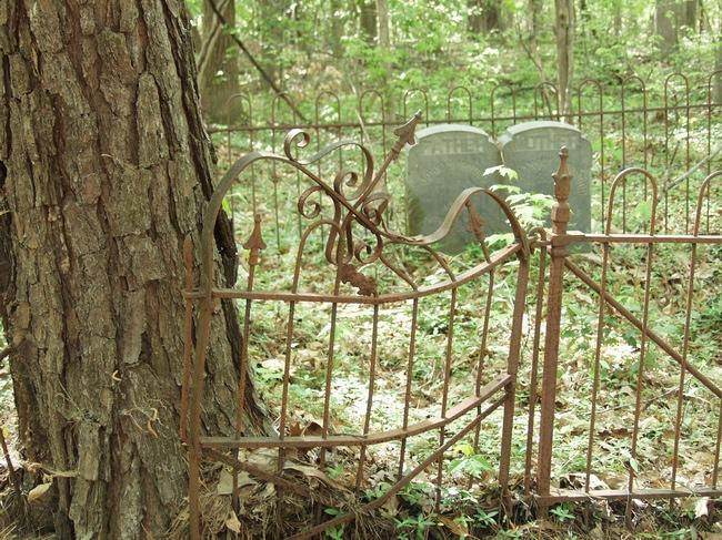
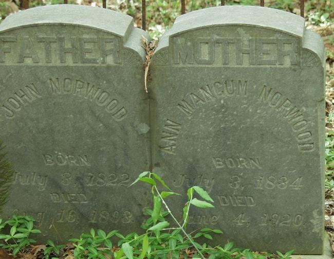
9 Attractions: Latitude: N35 57' 3.10" Longitude: W78 35' 38.85" There is an old Pontiac wagon in the woods. Probably an old homestead used to be here (there are a couple of old grave markers near the trail too) miles into the trail from the end of possum track. Near the other end of the trail are some very exclusive houses the trail will go along the side of a hill, then down over a nice small river (just more than a creek). The houses that are along this section are nice (they are far off the trail, but you can see them). This section is well traveled as it is near some subdivisions, and has easy access from the middle section of Possum Track Road.


10 Section 4 Possum Track Road to Bayleaf Church Road 2.40 miles 2.40 miles 240 feet 198 feet 1.26 miles 1.14 miles Section 4 Trail Vertical Profile This section is neat but parts can be flooded when the lake is really high. This section goes from game lands to national wildlife preserve areas. This is true for lots of sections, so during the late fall and early winter wear bright clothes! (deer season).
11 The section starts out close to some neighborhoods so you might get a dog or two barking at you from people s backyards (They are generally 200 yards or so off some sections of the trail. The section of the trail that is near Bayleaf Church Road is in the wildlife preserve, and is less traveled. It is a challenge because you go up a hill and then back down. Not too intense though Some old road beds to be found here they date back before automobiles judging by the trees growing up and the ruts that are evident in the old road beds. This trail is one of the more varied ones it starts out in a newer strand of pine trees fairly open and you can see the sky then it dives right into dense pine and hardwoods, wrapping around and finally coming out on a rise that is very wooded, but rocky as opposed to a nice lush mat of pine needles. This is a good hike! Attractions: Latitude: Latitude: N35 57' 30.3" Longitude: W78 36' 52.6" This is an old cement foundation. Also some other junk in the woods. An older house. There are thick vines growing up in the trees here this is because the land was cleared and the vines kind of took over normally the woods would be too dense for these things to grow any time you see vines and relatively clear undergrowth, it was probably an old homesite. Update: Dec. 20, 2005 the old house, and Hudson are gone. There is a large swath cut through the woods at this point about halfway on this trail. The trail is hard to follow just maintain your direction when the trail exits onto the nice clear cut woods and you will see the trail on the other side. Look for the white markers on trees to find your way if I get a chance, I ll update the GPS co-ordinates for where the trail is obscured. Estimated location: Latitude: N Longitude: W ' (From a topo map I marked the old Hudson with a GPS a few years ago). This entire area is zoned for housing (R80 watershed so the county says). Possibly a new subdivision?

12 Section 5 Bayleaf Church Road to Six Forks Road 1.11 miles 1.11 miles 112 feet 108 feet 2937 feet 2924 feet Section 5 Trail

13 Vertical Profile You can park on either end of this section right along the road again, on the gravel on the shoulders of the road. At the end of possum track watch for that fence when you park, if you are inside it, you might get locked in if you stay too long. It s easiest to park outside the gate and walk the 100 feet to the trail heads. This is a fairly easy section only one large hill, then a gradual grade upwards to Six Forks Road. Fairly quiet section of trail not as popular as the one near the dam or section 3. Attractions: none. There are some old road beds, and various old barb wire fences so if you insist, look for the old barb wire fence at Latitude: N35 57' 34.7" Longitude: W78 38' 26.1". This used to be all old farmland like in ponderosa kinds of farms, so there are all kinds of old fences that are grown into trees, etc, all along these areas.

14 Section 6 Six Forks Road to Blue Jay Point Park 1.85 miles 1.85 miles 290 feet 243 feet 1.04 miles 4301 feet Section 6 Trail

15 Vertical Profile This section can be confusing at Blue Jay Point Park. There are several trail heads, and many smaller trails that loop back around near the picnic areas. This section gets BUSY during the spring and summer there are soccer fields, a playground with bathroom facilities and many picnic tables. Finding your way around the actual point can be confusing but all the trails are clearly marked. There is a neat nature center here as well if you have time to visit. If you wish to park your car in the park itself, note the time the gates close (this particular park is at dusk usually between 7pm and 8pm depends on the time of the year). No attractions just a good trail.

16 Section 7 Blue Jay Point Park to Six Forks 0.86 miles 0.86 miles 75 feet 141 feet 0.37 miles 0.49 miles Section 7 Trail Vertical Profile This section I rarely hike by itself I usually do this one along with the next section. This is important to note because there are connectors usually bridges that I haven t included here these are just trail sections from trail head to trail head. Marching across a bridge will get you some extra distance, obviously.


17 Section 8 Six Forks Road Boatramp to Highway miles 1.75 miles 160 feet 146 feet 0.83 miles 0.91 miles Section 8 Trail Vertical Profile There are three confusing things on this trail. The first is the trail head at Six Forks Road. It starts into the woods and then abruptly ends up at the top part of the boat ramp parking area. The trail continues at the very top of the parking area - looks like an old grass clearing or maybe old road. It s not marked too well. As you are in the parking lot, facing away from the boat ramp at the top right hand corner of the upper parking lot this is where the other trail head is.


18 The next confusing spot occurs just before the trail ends on highway 98. The trail will come up on an old closed section of asphalt. The trail follows this road for about 100 yards before cutting back into the woods to the north towards highway 98. It s easy to find if you look for trees that have been cut as they fall across the road, and there are white dots with arrows painted on the road The third confusing spot occurs if you come from Six Forks Road the trail will wander around near the lake then you hit a section that goes back in the woods towards a neighborhood. It is well traveled kids and parents come down to the lake quite a bit here. Now the trail takes an abrubt right turn back towards the lake. Look CAREFULLY for the white dots on the trees that mark the trail when you see TWO dots on a tree, you need to make a 90 degree turn! If you miss it you just end up in the neighborhood it will be obvious. Backtrack until you see the trail markers. This is where you lost your way. When the lake is high, this section will flood, so a slight detour is necessary at times which is why you might miss the trail. Don t get discouraged this is a nice remote section of trail that has some neat scenery!

19 Section 9 Highway 98 to Shinleaf Campground 2.38 miles 2.38 miles 219 feet 175 feet 1.24 miles 1.14 miles Section 9 Trail
.")
20 Vertical Profile Nifty trail a nice hike. Nothing to note on this one very similar to other areas of the lake although this one is a bit less traveled which is nice. Of course, go out in 22 degree or below weather around here and there won t be anyone else on the trails! (My favorite time to hike! Middle of the winter!). The trail starts at highway 98, you see a house or two as you cross past the power lines then into the woods nothing to see until you reach the campground. The campground is a primitive campground foot traffic only kind of thing park in the lot, and hike your tent and supplies to the campsites. A bath house with water fountain if you need some water.


21 Section 10 Shinleaf Campground to New Light Road 0.46 miles 0.46 miles 33 feet 72 feet 0.16 miles 0.30 miles Section 10 Trail Vertical Profile The transition from the previous section to this one is tricky the trail head is towards the entrance of the park you will want to head towards the bath house and parking lot, but you find the trail head at the base of the parking lot away from the bath house almost
.")
22 like you are going to follow the road back out of the park away from the campground. You can t clearly see it from where the last trail exits. This trail is a quick trip from the campground to New Light Road. There is parking along new light road (normal gravel areas near the trail heads). The only trick is the transition from this section to the next section if you are coming from the campground the next trailhead is about 100 yards down the road from where you come out on new light road just turn to the right, following the guard rail the lake is to your right and the next trail head is on the left after 200 feet or so. Attractions: Latitude: N35 59' 40.29" Longitude: W78 39' 22.48" Right at the trail head, just off the parking lot is an old family graveyard. Birthdates in the early 1800 s, and most died before the turn of the century. Hey you will run across a lot of these smaller family cemeteries if you hike around this area
23

24 Section 11 - New Light Road to Ghoston Road 0.41 miles 0.41 miles 57 feet 13 feet 0.30 miles 0.11 miles Section 11 Trail

25 Vertical Profile Not much to this section at all. A short, uphill climb to get to the next section. I count any section as a section if there is a trail head that ends in a road or a park. There is parking along New Light Road and plenty of it but there is NO PARKING along Ghoston road not that it is not allowed but there isn t much of a shoulder on the road, so you would be hard pressed to keep your car far enough off the road to keep it from getting hit.
 2.22 miles 2.")

26 Section 12 Ghoston Road to Highway 50 (creedmoor road) 2.22 miles 2.22 miles feet feet 1.05 miles 1.18 miles Section 12 Trail Vertical Profile

27 This section isn t bad. There is parking at New Light road, and you can walk the short distance to Ghoston road. There IS NO PARKING on ghoston road. The shoulder is small and there are signs that say you shouldn t park there. Not a bad hike fairly remote the end of this trail gets a bit worn, as it is near highway 50 and the start of this entire trail system. Up until you enter the top part of the park, the trail is quite nice. It meanders through the woods quite a bit doesn t really follow the lake like some of the other sections. You pass near a few homes, but not near enough to be bothered by dogs or anything else. Attractions: Latitude: N36 0' 11.8" Longitude: W78 40' 41.9" Some old stone markers in the woods. I believe these types of markers were used to survey and mark old family graveyards. This is near an old homestead that was abandoned sometime in the 1950 s (judging by the age of the junk around it). Latitude: N36 0' 15.21" Longitude: W78 40' 50.84" This is the center of the foundation. There is crap all around and you can t figure out where the house used to be. CAREFUL there are garbage pits and some older foundations that are lower than the surrounding woods. This is bad because you might hurt yourself. So take care when hiking around the crap left in the woods (old tires, appliances, etc). Latitude: N36 0' 18.45" Longitude: W78 40' 57.05" Not sure what this stuff is. Parts of an old farm, judging by the spacing of the old building remnants (you have to look hard to see where they used to be nothing standing but a small livestock fence and feeder trough). The trail will hike right through all this crap, so you don t have to go far. I haven t hiked through it all it s mostly what is left over when people leave garbage. Rusted tin roofs and appliances. Barb wire. There is a good view of the lake from the bridge at highway 50 at the end of the trail (or the beginning, depending on which way you went. Well, a good view for this lake, as it is not the prettiest lake I have ever seen!


28 Section 13 Highway 50 (creedmoor road) to Boyce Mill Road 5.28 miles 5.28 miles feet feet 2.42 miles 2.86 miles Section 13 Trail Vertical Profile
.")
29 This section of trail is new as of mid There are several intersecting unofficial sections of trails here that have been hiked and mountain biked for several years. The trailhead here starts on the opposite side of highway 50 that s the left side if you are heading away from Raleigh (trail heads west). Across the street you can see the big sign that is the start of the Falls Lake Nature Trail. These sections are connectors not sure if it s part of the official falls trail or not. Don t really care I m just hiking and mapping it. These are supposed to connect all the way over to Eno at some point. I ll hike them and add them as I get time. Several interesting things to see here a nice stream, near the Boyce Mill Road area you have to cross it on foot not deep, but the rocks are angled funny and a bit moss covered so watch your footing! (and, if you have a dog, it s hard to persuade them not to lay down on the rocks where the water runs past). Several intermediate trailheads are difficult to spot you come out on cleared area and have to walk along the treeline to find the next one. Remember the first time, the trail enters back to the right, the second it s straight across the 3 rd, it s uphill and on the opposite side (about 150 feet). They re all marked with the white dots or the metal stake telling you not to ride motorcycles, horses, etc Several old houses / farm buildings. I don t find these particularly interesting, although one is still standing and in relatively nice shape.
30 Big thank you to the following people for feedback which has improved this document: Matt for pointing out a few errors when this was first created. Mike G for the Blue Jay Point correction it s a Wake County Park, not a State Park! All those who write periodically, just when I think about getting rid of any web stuff out there I m just a computer geek with a GPS that likes to hike. Drop me a line, let me know what you think. walker@intrex.net NOTE: I have also been uploading the data to Google Earth, if anyone cares. Also uploaded most of Umstead from older maps to google earth as well.
The temperature is nice at this time of year, but water is already starting to be scarce.
 In March of 2003, Scott Morrison and I went backpacking in the Grand Canyon. The temperature is nice at this time of year, but water is already starting to be scarce. Another issue with this time of year
Charnley Explorer June 24 - July 15, 2018 Bachsten Creek and the Charnley River. Second draft: 14 November 2017
 Charnley Explorer June 24 - July 15, 2018 Bachsten Creek and the Charnley River. Second draft: 14 November 2017 The best part of the original section one is now part of out Gibb Road Gorges trip. The dates
Tiger Mountain State Forest:
 98 60 hikes within 60 miles: SEATTLE 20 Tiger Mountain State Forest: West Tiger Mountain Three Loop i KEY AT-A-GLANCE INFORMATION Length: 5.1 miles round-trip Configuration: Loop Difficulty: Moderate difficult
Telluride-to-Moab Alternative Singletrack Options
 Telluride-to-Moab Alternative Singletrack Options Day 1 Day 1 Alternate 1: Galloping Goose to Deep Creek. 18.4 miles, ascent 3,530ft, descent 1,388ft. This is fun, flowey, moderate to intermediate singletrack
Difficult Run Stream Valley Park
 Difficult Run Stream Valley Park The more intense mountain bikers have known about for Difficult Run for some time. Equestrians have known it longer. Eight miles of unpaved trail, the Rails to River Trail
Grizzly Peak A - East Ridge July 15, 2012
 Grizzly Peak A - East Ridge July 15, 2012 Difficulty: Difficult Class 2/Class 3 Upper Elevation: 13,995 feet Trailhead Elevation: 11,360 feet Elevation Gain: 3,000 feet Round-trip Length: 6.0 miles Trailhead:
A Publication of Friends of Sleeping Bear Dunes
 A Publication of Friends of Sleeping Bear Dunes 2014, Friends of Sleeping Bear Dunes, P.O. Box 545, Empire, MI 49630 www.friendsofsleepingbear.org info@friendsofsleepingbear.org Learn more about the Friends
beach. Make the ford and follow the trail out to the junction with Red Creek Tr in an open grassy area.
 Description: This is a moderate to slightly strenuous 22.8 mile backpack (add 2.6 miles if you do the packless out and back to the Lion s Head) that will have you exploring nearly every thing that is The
throu Booth Hill Green Belt
 s k r a p s l l u b m u r T Explore gh Geocaching throu Booth Hill Green Belt This was originally a concept to try and preserve some of the land in our town, without hurting the developers that are creating
Congewai Track Head (East) to Watagan Headquarters
 to Watagan Headquarters") Congewai Track Head (East) to Watagan Headquarters 7 hrs Hard track 17.2 km One way 4 973m This full day walk starts from the Congewai valley trackhead (east) and follows the Great North Walk up into the
Congewai Track Head (East) to Watagan Headquarters 7 hrs Hard track 17.2 km One way 4 973m This full day walk starts from the Congewai valley trackhead (east) and follows the Great North Walk up into the
Skiing and Snowshoes on Un-groomed Fernan Saddle Terrain
 Skiing and Snowshoes on Un-groomed Fernan Saddle Terrain Three ski or snowshoe routes are available from the Fernan Saddle Parking Lot which either do not cover routes ordinarily groomed for snow machine
Abbotts Falls Walking Track
 Abbotts Falls Walking Track 3 hrs 7.3 km Circuit Hard track 329m This circuit takes you through both dry and moist forest, using a combination of walking trails and wider tracks. The side trip to the dammed
Trail Beginning Elevation: 7553 ft The Poison Creek Trailhead is located at the end of National Forest Road 646E (NF-646E).
.") West Mountain Trails Poison Creek Trail #134 Length: 2.9 miles (4.7 km) Difficulty Horseback: A good trail for the first time west mountain rider, some steep sections Hiking: Most Difficult USGS Maps:
West Mountain Trails Poison Creek Trail #134 Length: 2.9 miles (4.7 km) Difficulty Horseback: A good trail for the first time west mountain rider, some steep sections Hiking: Most Difficult USGS Maps:
AOTA ArtTrek Locations
 AOTA ArtTrek Locations ArtTrek is a summer-long Grand County, CO art adventure. Highlighted by snow-covered mountain vistas and rolling meadows threaded with sparkling streams and rivers, numerous sites
CELEBRATE WEST GREENWICH GEOCACHING THROUGHOUT WEST GREENWICH
 CELEBRATE WEST GREENWICH GEOCACHING THROUGHOUT WEST GREENWICH The West Greenwich Land Trust (WGLT) is sponsoring Celebrate West Greenwich, an event designed to celebrate the beauty and history of scenic
INTERMEDIATE. mayorsmtbchallenge.org
 mayorsmtbchallenge.org Redding s second local Mountain Bike Challenge uniting current and new bicyclists in a friendly self-competition highlighting our diverse trail system. INTERMEDIATE Mule Ridge Cosmos
Other Agencies and Organizations
 Daniel Boone National Forest 1700 Bypass Road WInchester, KY 40391 859-745-3100 Location Northern terminus is near Morehead, Kentucky. Southern terminus is located in the Big South Fork NRRA in Tennessee.
Cataloochee. Fishing Species Rainbow Trout and Brook Trout. Recreation
 Cataloochee River Information The Cataloochee River is located in the historic Cataloochee Valley--a relatively remote part of Smoky Mountain National Park. The campground is a secluded setting and offers
Below is an example of a well laid-out template of a route card used by the Sionnach Team which is a good format to begin with.
 Route Card A route card is used as a navigational aid to hill walkers by setting out a step by step plan for an intended hike. It is good practice to make out a route card before every hike you or your
Erskine Creek via Pisgah Rock and Jack Evans
 Erskine Creek via Pisgah Rock and Jack Evans 4 hrs 30 mins 7.1 km Circuit Very experienced only 6 421m This walk visits some great lookouts and explores the lower section of Erskine Creek. Most of the
It s going to be minute clean up minimum. You re going to be running late today for sure.
 ***IMPORTANT DISCLAIMER*** Please DO NOT copy and paste directly to your site without changing the article considerably to suit your niche site's original angle (Google WILL penalize duplicate content)
Route #2) Mt. Massive - Southwest Slopes
 Mt. Massive - Southwest Slopes") Route #2) Mt. Massive - Southwest Slopes Difficulty: Class 2 Ski: Advanced, D6 / R2 / III Exposure: Summit Elevation: Trailhead Elevation: Elevation Gain: Round-trip Length: Trailhead: County Sheriff:
Route #2) Mt. Massive - Southwest Slopes Difficulty: Class 2 Ski: Advanced, D6 / R2 / III Exposure: Summit Elevation: Trailhead Elevation: Elevation Gain: Round-trip Length: Trailhead: County Sheriff:
Black Hill Regional Park, Little Seneca Lake
 Black Hill Regional Park, ittle Seneca ake ittle Seneca ake, in Black Hill Regional Park, is a reservoir created after a previous drought struck the Washington area. The park is under Maryland-National
Route #1) Mt. of the Holy Cross - North Ridge
 Mt. of the Holy Cross - North Ridge") Climbing 14ers can be very dangerous, please read the Mountaineering Safety Page and make sure you have a map+compass and can use them effectively, without the help of electronic devices. Route #1) Mt.
Climbing 14ers can be very dangerous, please read the Mountaineering Safety Page and make sure you have a map+compass and can use them effectively, without the help of electronic devices. Route #1) Mt.
Eakin Community Park. Getting There
 Eakin Community Park Quiet woods along the Accotink Creek are the hallmark of Eakin Community Park. Actually a string of smaller parks, Eakin is made-up of Mantua Park, Kern Drive Park, Eakin Park, Woodburn
HAUNTING ON AVENDALE ROAD HAL AMES
 HAUNTING ON AVENDALE ROAD HAL AMES It was August of 1979 when the police raided the house over on Avendale Road. What had been going on there had been happening for a very long time. Many of the people
MP : The Big Chief Overlook and the Glen
 MP 253 254: The Big Chief Overlook and the Glen The mile between MP 253 and 254 has lots of history in it. It includes the only recorded remains of the Victory Highway on the Clear Creek County side of
Ribbon Cliff - Ribbon Mesa text and photos by Charlie Hickenbottom
 Ribbon Cliff - Ribbon Mesa text and photos by Charlie Hickenbottom Looking for something a little different than Sage Hills or Saddlerock? Perhaps something a little wilder, a little less traveled? Look
Axes. The information below will assist the Scout in obtaining their Forester badge.
 Axes The information below will assist the Scout in obtaining their Forester badge. Axes can come in different shapes and sizes, the two axes that are of most relevance to any Scout Troop will be the HANDAXE
Greenbush Town Hall / Fire Station
 Page 1 of 18 Course Description Greenbush Town Hall / Fire Station Both races start in front of the Greenbush Town Hall / Fire Station, just south of Highway 23 on Sugarbush Road. Parking will be in the
Camp Jack Wright PERMANENT ORIENTEERING COURSE (2004)
") Camp Jack Wright PERMANENT ORIENTEERING COURSE (2004) WHAT IS ORIENTEERING? The skill which enables a person to navigate with a map. In the competitive sport, the winner is the person who finishes in the
Camp Jack Wright PERMANENT ORIENTEERING COURSE (2004) WHAT IS ORIENTEERING? The skill which enables a person to navigate with a map. In the competitive sport, the winner is the person who finishes in the
Safety Tips for Children Grades K-5
 Safety Tips for Children Grades K-5 Sexual Assault Most grown-ups are nice to kids and care about what happens to them. But every now and then there are grown-ups who try to touch a child in a way that
Crystal Lake Area Trails
 Lake Area Trails Welcome to the Lake area of the Big Snowy Mountains! This island mountain range in central Montana features peaks reaching to 8,600 feet and long, high ridges from which vistas of the
Leura Cascades to Gordon Falls Reserve
 Leura Cascades to Gordon Falls Reserve 1 hr 15 mins 1.8 km One way Moderate track 200m From Leura Park to Gordon Falls Park, this diverse walk offers fantastic views of the Jamison Valley, as well as two
Merritts Traverse. 1928m
 Merritts Traverse 3 hrs Hard track 5.8 km Circuit 4 167m This walk starts with a scenic journey to the top of the hill on the chairlift. Starting along Merritts Nature walk, this walk soon detours down
GOLDEN EARS PROVINCIAL PARK
 GOLDEN EARS PROVINCIAL PARK Trail Information as of October 10 th 2015 Do not underestimate the mountainous wilderness of Golden Ears Provincial Park. The combination of rugged terrain and rapidly changing
UMASS CROSS-COUNTRY Trails
 UMASS CROSS-COUNTRY Trails 1) EGG (43 min) (A) From Cage proceed to North Pleasant street (by campus pond). Make left and head toward LGRT and pass School of Education. Pass Puffton Apt complex (on left)
Investigative Report #2 Old Montauk Highway May 18, 1999
 archived as http://www.stealthskater.com/documents/montauk_trip_02.pdf more related documents at http://www.stealthskater.com/px.htm note: because important websites are frequently "here today but gone
Trail Phasing Plan. Note: Trails in the Clear Creek Canyon area (Segments will be finalized in the future to minimize wildlife impacts
 Note: Trails in the Clear Creek Canyon area (Segments 2 5 and a future JCOS connection) will be finalized in the future to minimize wildlife impacts Trail Phasing Plan P Parking 3 Easy Trail Intermediate
Section 7: Pick Up Where You Left Off! S-Tree Road over the Todd Road
 2018 TRACE NOTES Helpful information for your adventure on Section 7 of the Hiker Challenge. Start Point S-Tree Rd. End Point Intersection Todd Rd. / Hale Ridge Rd. WEATHER DECISION Weather Alert!!!! Potential
HIKING/BIKING IN MERRITT AREA
 HIKING/BIKING IN MERRITT AREA Coquihalla Lakes: Just inside the southern boundary of BC Park's Coquihalla Summit Park, a nice little twin lakes paddle with a private campground & lodge is the Coquihalla
RIDGEFIELD PARKS February 2016
 RIDGEFIELD PARKS February 2016 Hayden Park Neighborhood Park Amenities Sign with Name of Park and City of Ridgefield Logo Lamp Post Parking Area Play Set Swings Sign with Playground Rules Durable Benches
Cajun Pines. Hunting Club. Rules & By-Laws
 Cajun Pines Hunting Club REVISED 04/15 Table of Contents Article I Membership Page 3 Article II Removal from Membership Page 3 Article III - Campground Page 4 Article IV Hunting Rules Page 6 Article V
CIEC 9 PEAKS AWARD SUPPLEMENT POSSIBLE ROUTES FOR THE 9 PEAKS AWARD TRIP
 CIEC 9 PEAKS AWARD SUPPLEMENT POSSIBLE ROUTES FOR THE 9 PEAKS AWARD TRIP As you plan your trip, be aware of 3 regulations in this wilderness: 1. Camp only in designated campsites. 2. No campfires allowed.
43 STONE MOUNTAIN LOOP
 204 60 hikes within 60 miles: atlanta 43 STONE MOUNTAIN LOO i KEY AT-A-GLANCE INFORMATION LENGTH: 5.5 miles CONFIGURATION: Loop DIFFICULTY: Easy SCENERY: Views of Stone Mountain and Confederate Memorial;
Location: Height: Access: Distance: Elevation: Season: Difficulty: Lat/Long: Directions:
 Upper Eagle Falls Upper Eagle Falls (~20 ft.) is a short hike up from the roadside at the Eagle Falls picnic area. It is very difficult to get a parking spot here during the day, so it is recommended to
1. Drive to Lake Cowichan via Highway 18 (which connects to the Trans-Canada Highway just north of Duncan)
") Driving Instructions to the Walbran Valley via Lake Cowichan (updated July 2018) 1. Drive to Lake Cowichan via Highway 18 (which connects to the Trans-Canada Highway just north of Duncan) 2. At the traffic
Driving Instructions to the Walbran Valley via Lake Cowichan (updated July 2018) 1. Drive to Lake Cowichan via Highway 18 (which connects to the Trans-Canada Highway just north of Duncan) 2. At the traffic
Mt. Elbert East Ridge
 Mt. Elbert East Ridge Difficulty: Class 1 Exposure: None Summit Elev.: 14,440 feet Trailhead Elev.: 10,400 feet Elevation Gain: 4,100 feet Roundtrip Length: 8.5 miles Trailhead: South Elbert (near Twin
PLAINFIELD BOARD OF ZONING APPEALS October 15, :00 P.M.
 CALL TO ORDER PLAINFIELD BOARD OF ZONING APPEALS October 15, 2012 7:00 P.M. Mr. Monnett: I will now call to order the Plainfield Board of Zoning Appeals meeting for October 15, 2012. ROLL CALL/DETERMINE
Hiking Las Vegas.com
 Hike: Mt. Wilson via First Creek Canyon route Trailhead: First Creek marked Distance: 10 miles up and back Elevation gain: 3,400 feet Elevation of Peak: 7,070 feet Time: 7 to 9 hours (up and back) Difficulty:
Mary Allen Park Public Workshop Data
 Mary Allen Park Public Workshop Data Mary Allen Park Today The following is a full listing of all comments received at the Public Workshop event held on Thursday, October 8th, 2015, from 6:30 to 8:30 p.m.
Instruction Manual. A step-by-step guide to building your own igloo. Andy Meldrum All rights are reserved.
 Instruction Manual A step-by-step guide to building your own igloo. Andy Meldrum 2007 1 Contents 1 Introduction 2 Get properly kitted up. 3 Choose and prepare your site. 4 Create the base. 5 Mark out the
Personal History. Curiosity Creek on the end of Jenal Road in 2003 (USF) Curiosity Creek in 2003 (USF)
 Curiosity Creek in 2003 (USF)") Oral history narrative from a joint program with Hillsborough County and the Florida Center for Community Design and Research Curiosity Creek The following narrative comes from an interview with long-time
Oral history narrative from a joint program with Hillsborough County and the Florida Center for Community Design and Research Curiosity Creek The following narrative comes from an interview with long-time
BEGINNER. mayorsmtbchallenge.org
 mayorsmtbchallenge.org Redding s second local Mountain Bike Challenge uniting current and new bicyclists in a friendly self-competition highlighting our diverse trail system. BEGINNER N Churn Creek Greenway
Survey Summary. 1. Overview. Pilot Implementation Survey Toronto Parks & Trails Wayfinding Strategy (Phase II) September 30 November 6, 2017
 September 30 November 6, 2017") Survey Summary Pilot Implementation Survey Toronto Parks & Trails Wayfinding Strategy (Phase II) September 30 November 6, 2017 1. Overview Between September 30 and November 6, 2017, the City of Toronto
Survey Summary Pilot Implementation Survey Toronto Parks & Trails Wayfinding Strategy (Phase II) September 30 November 6, 2017 1. Overview Between September 30 and November 6, 2017, the City of Toronto
BRYCE CANYON COUNTRY Boulder Mountain Scenic backways itinerary
 BRYCE CANYON COUNTRY Boulder Mountain Scenic backways itinerary Boulder Mountain Area The high plateaus of the Aquarius Plateau (Boulder Mountain), are heavily forested and covered in countless winding
This Passport: Revised October 20, 2017, EAM # Discovering the Trails of Webster, NY
 This Passport: Revised October 20, 2017, EAM #161923 Discovering the Trails of Webster, NY The Town of Webster invites you to explore and experience our diverse outdoor adventures! Here s your opportunity
Dadder Cave and Jack Evans track
 Dadder Cave and Jack Evans track 2 Days 10.3 km Circuit Very experienced only 535m This fairly short overnight walk is a great way to explore Erskine Creek. The walking along Erskine creek is mostly off
Orienteering. The fundamental outdoors skill!
 The fundamental outdoors skill! Orienteering Nothing will make you feel more confident in the out of doors like knowing how to find your way in the woods. Orienteering Prepared by: Jeffrey Lybarger Assistant
Driving Time: 3 hours (allow extra time for stops)
") Scenic Byways loop This journey takes visitors through the eastern edge of Mt. Rainier National Park and along two of Washington s most beloved scenic byways, the Chinook Byway and the White Pass Scenic
Scenic Byways loop This journey takes visitors through the eastern edge of Mt. Rainier National Park and along two of Washington s most beloved scenic byways, the Chinook Byway and the White Pass Scenic
Park Activity Book. Start your adventure with Buddy Bison. Explore outdoors, the parks are yours!
 Park Activity Book Start your adventure with Buddy Bison. Explore outdoors, the parks are yours! National Park Trust www.parktrust.org Park Adventure Booklet Visit www.buddybison.org to get your own Buddy
Whiteside Mountain Land Owned by: Location: Trails:
 Whiteside Mountain Latitude: 35 05.123 N Longitude: 083 07.933 W Elevation: 1,503m Land Owned by: US Forest Service Nantahala Ranger District 828-524-6441 Location: Jackson County, NC Turn off of US Highway
Little Grand Canyon near Pomona, Illinois
 Little Grand Canyon near Pomona, Illinois Below: View of the trail and the terrain created using the Map My Hike app Below: Summary of the hike created using the Map My Hike app Presented by: Jennifer
CAMELBACK MOUNTAIN: CHOLLA TRAIL
 CITY OF PHOENIX :: Camelback Mountain: Cholla T rail 21 CAMELBACK MOUNTAIN: CHOLLA TRAIL IN BRIEF Camelback Mountain is the tallest point in the city of Phoenix. From the 2,704-foot summit of Camelback,
Watch Your Paws! A Young Person s Guide to Respecting Nature. Written and Illustrated By Steve Reid
 Watch Your Paws! A Young Person s Guide to Respecting Nature Written and Illustrated By Steve Reid Watch Your Paws It can be fun to play outdoors. There is lots of room to run around, and there is so much
Grade Two Introductory Safety Training
 Grade Two Introductory Safety Training Grade level: 2 Introduction: This lesson will cover the proper procedure students must follow to cross the street safely. Failure to follow this procedure is statistically,
Rogue Gorge (Mt. Stella) Roadless Area-- T30S R3E (primarily in portions of Sections 23, 26, 33, 34 & 35)
 Roadless Area-- T30S R3E (primarily in portions of Sections 23, 26, 33, 34 & 35)") Rogue Gorge (Mt. Stella) Roadless Area-- T30S R3E (primarily in portions of Sections 23, 26, 33, 34 & 35) Rogue River-Siskiyou National Forest--High Cascades Ranger District Upper, higher elevation trail
Rogue Gorge (Mt. Stella) Roadless Area-- T30S R3E (primarily in portions of Sections 23, 26, 33, 34 & 35) Rogue River-Siskiyou National Forest--High Cascades Ranger District Upper, higher elevation trail
Victoria Falls and Grose Valley to Blackheath Station
 This walk explores a fantastic section of the Grose Valley. Starting above Victoria Falls, the walk explores the cascades before dropping into the valley for the first nights rest at Burra Korain campsite.
Langton Lake Park Implementation Planning Session One 6 June Attendees signed in
 27 Attendees signed in Meeting summary Following an overview of the Parks and Recreation Renewal Program and the key directions of the Parks and Recreation System Master Plan, meeting participants were
Slad over to Pitchcombe and back
 The walk climbs up from Slad over Wickridge Hill, descends to near Pitchcombe, then climbs back over Wickridge hill and round the back of Slad. Page 1 Start Point: SO 8718 0732 The Woolpack, Slad Length:
Oregon Section B - Page m
 Oregon Section B - Page 1 5 35000m 5 36000m 5 37000m 5 38000m 46 57000m 46 58000m Hwy5B - Interstate Highway 5 - mi 1716.4-4271 ft RD1717 - PCT departs paved Old Highway 99 - mi 1716.8-4357 ft PL1717 -
Colorado s forests are slated to lose thousands of miles of roads through the new OHV Route Designation process. DON T LET IT HAPPEN!
 Colorado s forests are slated to lose thousands of miles of roads through the new OHV Route Designation process. DON T LET IT HAPPEN! This packet identifies many roads that you may lose if you don t act.
Isle Royale Info Trip Packages. The Greenstone Ridge Trail
 s East Section West Section Total Miles 42.7 Difficulty East to West 6.884 Difficulty West to East 6.965 [This is based on 7 Day Shorter Miles sample itinerary. However, difficulty is close to the same
Historic Highway Advisory Committee To Meet in The Dalles
 In This Issue Get Involved Highway Gets Major Endorsement New Life for the Old Road Bike Pods and Hubs Time Travel on the Historic Highway Gorge Ride 2014 The Historic Columbia River Highway News is your
CRANBERRY. Introduction
 Introduction Introduction The Cranberry Boulders are a group of 60 problems set in a beautiful mossy forest above the Cranberry Creek. The boulders are located approximately 36km south of Revelstoke on
Bankhead Lake TWO PARCELS AND 1 LOT FOR SALE
 OVERVIEW NORTH PARCEL ACRES: 46 WATERFRONT: 1,227 Front Feet PRICE: $350,000 PER ACRE: $7574 PER FRONT FT. $285 SOUTH PARCEL ACRES: 22 WATERFRONT: 1,381 Front Feet PRICE: $295,000 PER ACRE: $13,170 PER
Ala-Kul trekking guide.
 Ala-Kul trekking guide. The marshrutka 101 brings you to the entrance of the park. For 400 KGS, a taxi will stop between the entrance and the broken bridge, saving at least 1 hour of walk. Download me
2. Buck s Overnight Lodge - A nice place to stay on 300 acres.
 FENTRESS COUNTY Major Draws to the area: A. The horse back riding trails through the Big South Fork B. Sgt Alvin York C. The Hwy 127 Longest Yard Sale through 5 states. Fentress County started it and hosts
BUILD YOUR VERY OWN FLYING SAUCER!! VERY EASY TO CONSTRUCT AND ADJUST FOR FLYING
 BUILD YOUR VERY OWN FLYING SAUCER!! VERY EASY TO CONSTRUCT AND ADJUST FOR FLYING. THIS LOW COST GLIDER CAN BE A REAL TREAT AT PICNICS AND GATHERINGS FOR KIDS AND ADULTS ALIKE! Copyright 2006 Dreambuilt
Hiking Las Vegas.com
 Hike: Juniper Peak up and back Trailhead: Oak Creek Canyon marked Distance: 5.5 miles round trip Elevation gain: 2,200 feet Elevation peak: 6,109 feet Time: 4 to 5 hours - Up and back Difficulty: 3 Danger
Great Basin Drive, Yosemite to Las Vegas (C18A-3)
") Great Basin Drive, Yosemite to Las Vegas (C18A-3) After finishing up with the California parks, I left Yosemite and entered the Great Basin, which spans a large area east of the Sierra Nevada mountains
Great Basin Drive, Yosemite to Las Vegas (C18A-3) After finishing up with the California parks, I left Yosemite and entered the Great Basin, which spans a large area east of the Sierra Nevada mountains
World War II Secret City Gates (As published in The Oak Ridger s Historically Speaking column on April 5, 2006)
") From 1943 to 1949 the city of Oak Ridge (fifth largest city in Tennessee) was not on any maps and existed as a secure gated community. The installation of fences and guard portals at the various roads
From 1943 to 1949 the city of Oak Ridge (fifth largest city in Tennessee) was not on any maps and existed as a secure gated community. The installation of fences and guard portals at the various roads
West Trails Trek Guide. Chief Pontiac Trail Credential Hikes
 West Trails Trek Guide Kensington Start Edition Chief Pontiac Trail Credential Hikes RDS.WTW.110609 WP# Dist. Accum. Dist. Accum. Feet Miles Meters Meters 1 0 0.0 0 0 2 410 0.1 125 125 3 164 0.1 150 275
Delaware Wildlife Area
 Delaware Wildlife Area 8 miles away from Delaware 4,670 acre Wildlife Area 1) Take Rt. 36/East Williams Street eastward 2) Take left onto Rt. 42/Lake Street 3) Slight left onto Horseshoe Rd./CR. 220 4)
Sponsored by. statestreet.com
 /STATESTREETISLANDWALK #ISLANDWALKJSY Sponsored by statestreet.com Important Information If you forget everything else PLEASE remember the following.» Remember to check OUT of every checkpoint» If you
Guthega to Mt Twynam. 2183m. 1583m. 6 hrs 45 mins 14.8 km Return. Experienced only. 913m
 Guthega to Mt Twynam 6 hrs 45 mins 14.8 km Return Experienced only 5 913m This walk starts from Guthega and makes its way along the Snowy River to the Illawong Lodge, via the Blue Cow Creek flying fox.
September Newsletter. Search for Ayios Georgios. Sharing experiences as we journey together
 Sharing experiences as we journey together Search for Ayios Georgios This is my third newsletter this year and comes 6 months after I published the last one. I decided to change the format for this edition
Piestewa Peak/Dreamy Draw Trail Guide
 Piestewa Peak/Dreamy Draw Trail Guide Trail #1A - Perl Charles Memorial Trail Length: 4.8 miles Elevation: 2,200 ft. - 1,340 ft. Difficulty: Moderate to difficult The Perl Charles trailhead is located
2016 Transit Service Review, Northwest and Inner City. Verbatim Comments Route 422 & 437. Public Engagement -What We Heard February March 2016
 Verbatim Comments Route 422 & 437 Feedback below was collected in February and March 2016 at engagement sessions and online. Content is captured as it was provided by stakeholders. No edits have been made.
Marilla Reservoir to Chestnut Ridge via Marilla Trails and Bullis Hollow Trail east to west
 USGS topographic maps useful to this hike are the Bradford and Stickney 7.5 minute sectionals. These notes are designed to assist in identifying distance and location using geophysical and man-made characteristics
(west) onto Charleston Boulevard. Drive 16 miles on Charleston and turn right into Red Rock
 onto Charleston Boulevard. Drive 16 miles on Charleston and turn right into Red Rock") Hike: North Peak and Ice Box Overlook up and back Trailhead: 2.5 miles up the Rocky Gap Road not mark Distance: 5 miles round trip Elevation gain: 2,694 feet Elevation Peak: 7,094 feet Time: 3 to 5 hours
Hike: North Peak and Ice Box Overlook up and back Trailhead: 2.5 miles up the Rocky Gap Road not mark Distance: 5 miles round trip Elevation gain: 2,694 feet Elevation Peak: 7,094 feet Time: 3 to 5 hours
Lava Mountain Trail Distance: Elevation Range: Trail Type: Difficulty: Season: Driving Distance: Driving Time: USGS Maps: Pros Cons
 Lava Mountain Trail Distance: 13.4 miles (including the side trip to North Star Lake) Elevation Range: 5900'-8330' Trail Type: singletrack Difficulty: moderate Season: late June-October Driving Distance:
C E N T R A L C A T S K I L L S
 120 C E N T R A L C A T S K I L L S Central Catskills Once out of the southern parts of the Catskills, the Long Path enters the more well traveled and civilized regions. The trail joins the Devil s Path,
Berowra Waters to Cowan Station
 Berowra Waters to Cowan Station 3 hrs 30 mins 7.2 km One way Hard track 597m This is a hilly walk out of the beautiful Berowra Waters valley to Cowan Station. There are many wide views across Berowra Creek
16.5 Mile Trek Guide. Chief Pontiac Trail Credential Hikes RDS.H
 16.5 Mile Trek Guide Chief Pontiac Trail Credential Hikes RDS.H.110609 WP# Dist. Feet Accum. Miles Dist. Meters Accum. Meters 1 0 0.0 0 0 2 961 0.2 293 293 3 820 0.3 250 543 4 866 0.5 264 807 4a 407 0.6
Victoria Falls Lookout to Blue Gum Forest
 Victoria Falls Lookout to Blue Gum Forest 8 hrs Experienced only 13.8 km One way 5 112m This long day-walk follows a remote track down from Victoria Falls lookout, passing the waterfall, and into the Grose
Officers. March President Louie Frick Vice President
 Officers President Louie Frick 541-327-1210 mining@teleport.com Vice President Steve Landis 503-999-8876 Secretary Jeff Farrand 503-371-3652 Treasurer Marshal Phares Government Affairs Paul Messersmith
The Cleo s Bath North Side Hike
 The Cleo s Bath North Side Hike This hike is a cross-country hike from Pinecrest Lake to the north side of Cleo s Bath. It is quieter and much less crowded than the normal route, which goes up the south
Asheville & WNC Hikes
 Asheville & WNC Hikes Amazingly, we have 3,000+ miles of free public hiking trails near Asheville, including 1,600 miles in the Pisgah and Nantahala National Forests, 850 miles in Great Smokey Mountains
Matthiessen State Park Dells Area Hike
 90 Easy Hikes Close to Home At the south end of the hike, you ll climb on top of a mound left over from a former coal-mining operation in the park. Not far from Goose Lake Prairie, the town of Morris hosts