PROPOSED NEW RICHMOND FOLK FESTIVAL MAIN STAGE VENUE AT TREDEGAR GREEN VENTURE RICHMOND JUNE 2013
|
|
|
- Francis Strickland
- 6 years ago
- Views:
Transcription

1 PROPOSED NEW RICHMOND FOLK FESTIVAL MAIN STAGE VENUE AT TREDEGAR GREEN VENTURE RICHMOND JUNE 2013

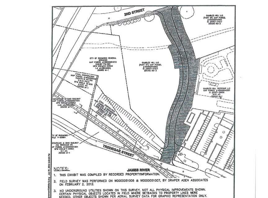
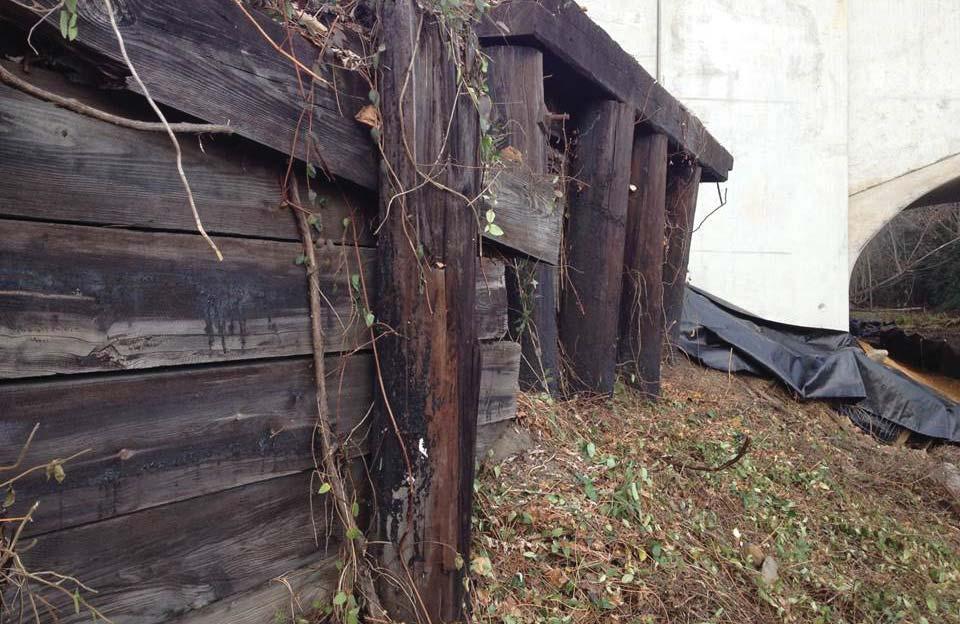
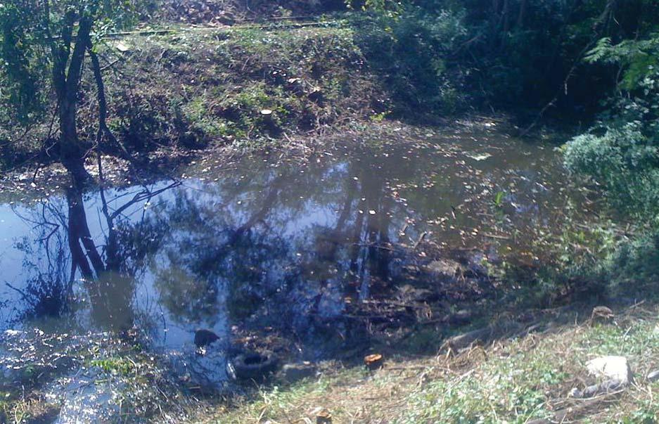
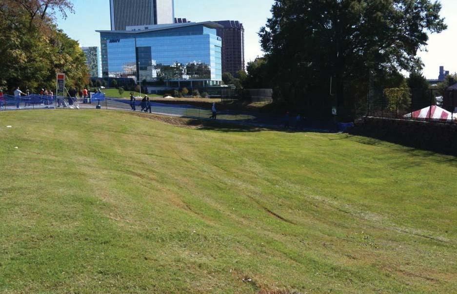
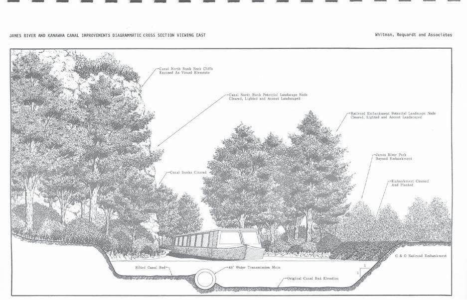
2 Venture Richmond proposes to develop a new main stage venue for the Richmond Folk Festival on property recently donated by NewMarket Corporation, immediately west of the American Civil War Center at Tredegar. In October 2012, NewMarket Corporation donated 3.9 acres of land valued at $3.6 million to Venture Richmond. Under a development agreement between the City, Venture Richmond, Dominion and NewMarket, a connector road was constructed on 1.2 acres of that property. Venture Richmond then donated the road parcel to the City in May 2013, leaving a residual of 2.7 acres for the new venue. As part of the agreement, Venture Richmond leased an additional 1.8 acre City parcel which will be incorporated into the new venue, which is sometimes referred to as an amphitheater, or grassy slope. The Richmond Folk Festival has become Richmond s most popular annual outdoor festival, drawing over 200,000 participants each year during a threeday weekend in October. During the past eight years, the main stage has been located on private property owned by NewMarket. That site is ultimately planned for commercial development. Venture Richmond would like to locate all of the Folk Festival venues closer to the river and Brown s Island, on land that is designated for public use and controlled by either the City, the Civil War Center or Venture Richmond. This desire is shared by NewMarket, which is facilitating the Folk Festival s goal through its generous donation of riverfront property for public use. The proposed new venue, designated as Tredegar Green in the City s recently adopted Riverfront Plan, consists of 4.5 acres, including the property leased from the City. The property slopes from the top of the hill at 2nd Street, near the Virginia War Memorial, down to Tredegar Street, offering spectacular views of the James River and the Downtown skyline. The property is bisected by the remnants of the James River and Kanawha Canal, which dates from 1785, and was toured by George Washington in The canal and the river once provided an active transportation artery as far west as Buchanan, until its decline in the 1850s. The canal was abandoned after the flood of 1877, and the tow path became a rail line. The original canal is a very important historic resource, which should be preserved. Unfortunately, over the last few decades the canal bed has become an overgrown, unsightly and unsafe ditch. The proposed project seeks to restore the canal to a profile that more closely resembles its original design. The tow path width, tow path elevation, canal width at top, and canal width at bottom, will be reconfigured in accordance with archaeological research to closely approximate what would likely have existed when the canal was created. Over the years, the canal features have been modified many times. The most significant change was an increase in the tow path elevation and an increase in the width to accommodate rail lines. The proposed project will return the tow path to a form that more closely approximates the original condition. In addition, the slopes will be softened to eliminate the safety hazard that currently exists as a result of the steep dropoffs. The bottom of the canal will not be disturbed, as it has become an isolated wetland, except for several feet on each side where the slopes meet the bottom. The proposed alterations will allow the canal to be maintained in a safe condition, and will allow the banks to be periodically mowed. The modifications will allow the public to experience the canal close-up, and to learn about the canal from interpretive signs that will be installed as part of the project. The project will also improve sight lines from the upper lawn area to the stage, allowing the site to function as the main Folk Festival venue. A bike pedestrian path will be constructed on the top of the tow path berm, connecting the North Bank Trail (which goes to Maymont) to the 2nd Street Connector. The future of the Richmond Folk Festival depends on this project. An adequate site that can safely accommodate the crowds is essential if the festival is to continue. This project will provide a permanent main stage venue for the festival, accommodating approximately 10,000 participants, and will help assure its long term future. 3NORTH TREDEGAR GREEN 2 PROJECT NARRATIVE


3 3NORTH TREDEGAR GREEN 3 PHOTOS : EXISTING SITE


4 3NORTH TREDEGAR GREEN 4 PHOTOS : EXISTING PARCELS


5 3NORTH TREDEGAR GREEN 5 PHOTOS : THE RICHMOND FOLK FESTIVAL


6 3NORTH TREDEGAR GREEN 6 PHOTOS : EXISTING CONDITIONS


7 3NORTH TREDEGAR GREEN 7 PHOTOS : THE TOW PATH


8 3NORTH TREDEGAR GREEN 8 PHOTOS : WEST TO MAYMONT


9 08 LEGEND MAIN STAGE VIP TENT ADDITIONAL TENT SPACE VENDOR TENT SPACE FOOD COURT RESTROOMS FESTIVAL BANNER HISTORIC CUPOLA ICON SOUND/AV TENT PEDESTRIAN BRIDGE CONNECTION TO NORTH BANK TRAIL EXISTING BRIDGE 13 FUTURE CONNECTION TO BELLE ISLE 14 EXISTING BELLE ISLE ACCESS LANDSCAPE BUFFER PEDESTRIAN PATH EXISTING BIKE TRAIL UPPER SEATING LAWN LOWER SEATING LAWN CANAL/WETLAND PEDESTRIAN PATH (ALONG TOWPATH) EXISTING GRAVEL ACESS AREA LANDSCAPING HISTORIC WALL REMNANT ON CITY PROPERTY ND STREET RAMP STREET TREES RETAIL VENDOR TENT REINFORCED TURF SITE SECTION LINE NORTH TREDEGAR GREEN 9 MASTER PLAN


10 LEGEND SIGHT LINE EXISTING GRADE PROPOSED GRADE NORTH TREDEGAR GREEN 10 SITE SECTION : ALTERNATE 1


11 CANAL DATA: HISTORIC CURRENT PROPOSED TOW PATH WIDTH 12 FEET 25 FEET 12 FEET TOW PATH ELEVATION 83 FEET 84.5 FEET 83 FEET CANAL BOTTOM ELEVATION NOT AVAILABLE 77 FEET 77 FEET CANAL TOP 50 FEET 67 FEET 50 FEET CANAL BOTTOM 30 FEET 37.5 FEET 25 FEET 3NORTH TREDEGAR GREEN 11 CANAL SECTION (FROM ALTERNATE 1)


12 LEGEND SIGHT LINE EXISTING GRADE PROPOSED GRADE NORTH TREDEGAR GREEN 12 SITE SECTION : ALTERNATE 2
MASTER PLAN EXECUTIVE SUMMARY
 Biscuit Run State Park Scottsville Road (State Route 20) Charlottesville, VA 22902 Biscuit Run State Park MASTER PLAN EXECUTIVE SUMMARY Department of Conservation and Recreation Division of Planning and
MORGAN CREEK GREENWAY Final Report APPENDICES
 APPENDICES MORGAN CREEK GREENWAY Appendix A Photos of Existing Conditions in Trail Corridor Photos of existing conditions Main trail corridor - February 2009 Photos of existing conditions south bank Morgan
River First Initiative and Waterworks Park
 River First Initiative and Waterworks Park The RiverFIRST proposal is critical to the creation of a larger regional parks and trails network, as well as ecological and infrastructure system. When realized,
Historical Documentation of the Site of Venture Richmond s Proposed Amphitheater
 "Richmond, from the hill above the waterworks"; engraved by W.J. Bennett from a painting by G. Cooke; Published by Lewis P. Clover (New York) c. 1843 Historical Documentation of the Site of Venture Richmond
BUSINESS OFFERING MEMORANDUM
 BUSINESS OFFERING MEMORANDUM PROPERTY OVERVIEW RIVERFRONT at las colonias PARK is a 140-acre mixed-use park owned by the City of Grand Junction. The park includes a 10,000-seat amphitheater, a whitewater
2. Goals and Policies. The following are the adopted Parks and Trails Goals for Stillwater Township:
 D. PARKS AND TRAILS 1. Introduction Stillwater Township s population is relatively low, with most residents living on rural residences on large lots. The need for active park space has been minimal in
Logo Department Name Agency Organization Organization Address Information 5700 North Sabino Canyon Road
 Logo Department Name Agency Organization Organization Address Information United States Forest Coronado National Forest 5700 North Sabino Canyon Road Department of Service Santa Catalina Ranger District
NEWBORO AND PORTLAND HARBOUR REDVELOPMENT PLANS
 INTRODUCTION The Municipal docks in both Newboro and Portland were transferred to the Township of Rideau Lakes by Parks Canada in 2002. Little has been done to improve the docks physical condition or role
LANDING S PARK CONCEPTUAL PLAN HAMILTON ANDERSON JANUARY City of Novi, Michigan. The Park at 13 Mile and Old Novi Road
 HAMILTON ANDERSON JANUARY 2012 LANDING S PARK CONCEPTUAL PLAN January 2012 Page 1 of 15 January 2012 PROJECT GOALS Activate the park by introducing new elements Provide clear access to the water and enhance
Transportation Supporting Dulles Airport
 Transportation Supporting Dulles Airport Committee for Dulles Economic Development and Transportation Committee July 12, 2018 Tom Biesiadny, Director Fairfax County Multiple Transportation Improvements
TEMPE BEACH PARK - RECOMMENDATIONS
 TEMPE BEACH PARK - RECOMMENDATIONS Tempe Beach Park has the potential to become a regional destination park, but it suffers from a host of physical and operational problems, as well as structural flaws.
Camping (Primitive) Camping (RV) Electrical Potable Water Grill Established Fire Pit Picnic Table
 Camping (RV) Electrical Potable Water Grill Established Fire Pit Picnic Table") Alden - 9th Road River Mile 777 Map: 38.20833, -98.32031 Managing Agency: Kansas Department of Wildlife, Parks & Tourism Nearest Community: Alden, Rice County Kansas Developed Amenities Provided Parking
Alden - 9th Road River Mile 777 Map: 38.20833, -98.32031 Managing Agency: Kansas Department of Wildlife, Parks & Tourism Nearest Community: Alden, Rice County Kansas Developed Amenities Provided Parking
Stephens State Park Trails
 TRAILS OF ALLAMUCHY MOUNTAIN & STEPHENS STATE PARKS Allamuchy Mountain and Stephens State Parks contain 28 marked trails providing access to diverse landscapes for walking, hiking, biking, bird-watching,
FOR SALE Rare Mid-Town Location
 FOR SALE Rare Mid-Town Location 1590 Willamette Street, Eugene Oregon 1590 WILLAMETTE STREET 2 Rare Mid-Town Location Address 1590 Willamette Street Eugene, Oregon 97402 This Building is located on a high
Lake Waconia Regional Park 6. Lake Waconia Regional Park
 Lower Lakeshore Trail Interpretive/Adventure Trail Multiple Seating & Observation Areas Flexible Day Use Recreation Area Docks/Fishing Group Camping Group Day Use Space Winter Gathering/Event Space -Season
TRINITY RIVER CORRIDOR
 TRINITY RIVER CORRIDOR MODIFIED DALLAS FLOODWAY PROJECT UPDATE May 12, 2015 Jon Loxley Project Manager Dallas Floodway Project Fort Worth District U.S. Army Corps of Engineers US Army Corps of Engineers
Mt. Hood National Forest
 United States Department of Agriculture Forest Service Mt. Hood National Forest Zigzag Ranger District 70220 E. Highway 26 Zigzag, OR 97049 503-622-3191 Fax: 503-622-5622 File Code: 1950-1 Date: June 29,
related to temporary banners, flags, A-frame signs, and other temporary sign devices for commercial advertising. (Lee Plemel,
 STAFF REPORT Report To: Board of Supervisors Meeting Date: May 3, 2018 Staff Contact: Lee Plemel, Community Development Director Agenda Title: For Possible Action: To provide direction to staff regarding
Blueways: Rivers, lakes, or streams with public access for recreation that includes fishing, nature observation, and opportunities for boating.
 Parks, Open Space and Trails PRINCE WILLIAM COUNTY 2008 COMPREHENSIVE PLAN TRAILS PLAN CONTENTS The components of the trails plan are: Intent Definitions Goals, Policies, and Action Strategies Trails Map
Everett Riverwalk Life style explore
 Life style explore Project Overview The 217-acre Everett Riverfront redevelopment is visible from I-5 with traffic counts charted at 170,000+ vehicles per day with direct freeway access from 4-way interchange.
TOWPATH MOWING GUIDELINES
 TOWPATH MOWING GUIDELINES 24 September 2007 CONTENTS Introduction Scope and Status of Guidelines Influences on the Guidelines Health and Safety Biodiversity INTRODUCTION Towpath management is a key issue
Wilds. Headwaters. Lakes. Oxbows. Falls
 56 5 4 3 Wilds Headwaters Lakes Oxbows Falls 57 Zones It could be said the on-the-ground essence of this master plan appears within the next 6 pages of this report. As we learned in the preceding Cultural
The Narrows Waterfront Park A Crown Jewel for Southern Brooklyn
 The Narrows Waterfront Park A Crown Jewel for Southern Brooklyn In New York, the unquestioned popularity of urban spaces such as Riverside Park, the High Line, Brooklyn Bridge Park and others has demonstrated
Ballston Common Mall 4238 Wilson Blvd., # 3104 Arlington, Virginia 22203
 November 24, 2003 TO: FROM: APPLICANT: BY: The County Board of Arlington, Virginia Ron Carlee, County Manager ComedySportz, DC Ballston Common Mall 4238 Wilson Blvd., # 3104 Arlington, Virginia 22203 Elisabeth
Innerbelt Bridge Contract Group 2 Tremont / Towpath Trail and Gateway January 8, 2013
 Innerbelt Bridge Contract Group 2 Tremont / Towpath Trail and Gateway January 8, 2013 Cleveland Innerbelt Construction Schedule former schedule 2011 Winter Begin Construction Innerbelt CCG1 (WB Bridge)
Inner Harbor 2.0. The resulting Inner Harbor 2.0 Plan provides a road map for a more sustainable, attractive and active Inner Harbor.
 Inner Harbor 2.0 In 2012, recognizing that some of the Inner Harbor infrastructure had outlived its useful life, the City completed a State of Good Repair Study, while Waterfront Partnership, along with
Huntington Metro Station Joint Development
 Finance and Capital Committee Information Item II-C September 13, 2018 Huntington Metro Station Joint Development Page 120 of 284 Washington Metropolitan Area Transit Authority Board Action/Information
DRAFT - APRIL 13, 2007 ROUTING STUDY FOR TRAIL CONNECTIONS BETWEEN CALAIS AND AYERS JUNCTION
 DRAFT - APRIL 13, 2007 ROUTING STUDY FOR TRAIL CONNECTIONS BETWEEN CALAIS AND AYERS JUNCTION Abstract The vision for the East Coast Greenway is an off-road urban trail system running from Calais, Maine
ARLINGTON COUNTY, VIRGINIA
 ARLINGTON COUNTY, VIRGINIA County Board Agenda Item Meeting of July 10, 2004 DATE: July 1, 2004 SUBJECT: SP #193 SITE PLAN AMENDMENT for Elisabeth Demery to expand theater; located at 4238 Wilson Boulevard.
Crystal City Station Improvements. Project Overview. Table 2: North Entrance. Table 1: South Entrance. 20th St. S 18th St. S.
 Table 1: South Entrance Table 2: North Entrance 20th St. S 18th St. S Proposed Second Entrance Crystal Drive Existing Station Location Platform Future 4 th Track Future New Airport Connection (by others)
MONTGOMERY COUNTY PLANNING DEPARTMENT THE MARYLAND-NATIONAL CAPITAL PARK AND PLANNING COMMISSION
 MONTGOMERY COUNTY PLANNING DEPARTMENT THE MARYLAND-NATIONAL CAPITAL PARK AND PLANNING COMMISSION MCPB Item No. Date: 6/23/2016 Lucy V. Barnsley Elementary School Addition, Mandatory Referral MR2016027
Silver Lake Park An Environmental Jewel for the Citizens of Prince William County
 Silver Lake Park An Environmental Jewel for the Citizens of Prince William County The Prince William Park Authority Mission Statement states: The Prince William County Park Authority will create quality
Recreation and Park Commission, Capital Committee
 DATE: March 7, 2018 TO: THRU: FROM: RE: Recreation and Park Commission, Capital Committee Philip A. Ginsburg, General Manager Lisa Bransten, Director of Partnerships New Park at Francisco Reservoir Park
City of Haslett. City of East Lansing. City of East Lansing
 Central Park North (Nancy L. Moore Park) Lake Park North Expansion White Park Expansion #2 White Park Expansion #1 County East East Haslett East East TF87-212 Acquisition $90,000.00 Park. TF08-138 Acquisition
Restoration of Historic Streetcar Services in Downtown Los Angeles
 Restoration of Historic Streetcar Services in Downtown Los Angeles Alternatives Analysis Community Update Meeting November 3, 2011 Introduction Local lead agency: Metro Federal lead agency: Federal Transit
Head Pond Connector Trail Final Report Project Area: From Head Pond in Berlin to Rt. 110B in Milan
 Milan Trail Huggers ATV Club P.O. Box 42 Milan, NH 03588 Maintaining Trails in Milan, Stark and Dummer Head Pond Connector Trail Final Report Project Area: From Head Pond in Berlin to Rt. 110B in Milan
ROAD AND TRAIL PROJECT APPROVAL
 ROAD AND TRAIL PROJECT APPROVAL www.marincountyparks.org Marin County Parks, 3501 Civic Center Dr, Suite 260, San Rafael, CA 94903 DATE: July 12, 2017 PRESERVE: Gary Giacomini Open Space Preserve PROJECT:
COMMUNITY MEETING NOVEMBER 1, Wheaton Regional Park Pine Lake Trail
 COMMUNITY MEETING NOVEMBER 1, 2012 MEETING AGENDA I. Introduction of Project Team II. Trail Renovation Process III. Wheaton Regional Park IV. Pine Lake Trail Renovation Project V. Comments and Questions
MPRB: Southwest LRT Community Advisory Committee Issues and Outcomes by Location Current to: 12 November 2010
 MPRB: Southwest LRT Community Advisory Committee Issues and Outcomes by Location Current to: 12 November 2010 This is a compilation of issues and outcomes identified by the CAC. It is a work in progress,
3.0 EXISTING PARK & RECREATION SPACE
 3.0 EXISTING PARK & RECREATION SPACE TOWN PARK & RECREATION SPACE An inventory of current parks and recreation area in the Town of Cedarburg is shown in Table 3. These areas total roughly 381.89 acres.
Welcome to the Cross County Trail Public Input Session!
 Welcome to the Cross County Trail Public Input Session! Please sign in on the table below! What are we doing here? Camden County has proposed a bicycle and pedestrian trail spanning across the entire county.
NORTH HEMPSTEAD BEACH PARK MASTER PLAN
 NORTH HEMPSTEAD BEACH PARK MASTER PLAN COMMUNITY DESIGN CHARRETTE Supervisor Judi Bosworth Viviana L. Russell Peter J. Zuckerman Angelo P. Ferrara Anna M. Kaplan Lee R. Seeman Dina M. De Giorgio VISIONING
Georgetown-Lewes Rail/Trail Study. Rail/Trail Study: Cool Spring to Cape Henlopen State Park New Road Extension (House Resolution No.
 Georgetown-Lewes Rail/Trail Study Rail/Trail Study: Cool Spring to Cape Henlopen State Park New Road Extension (House Resolution No. 47) August 22, 2011 Presentation Outline Background Benefits Statewide
2016 Regional Transportation Alternatives Program (TAP) Grant Application
 Grant Application") 2016 Regional Transportation Alternatives Program (TAP) Grant Application PROJECT TITLE: Yelm-Tenino Trail Extension Feasibility Study TRPC use only GENERAL PROJECT INFORMATION Agency or Organization City
2016 Regional Transportation Alternatives Program (TAP) Grant Application PROJECT TITLE: Yelm-Tenino Trail Extension Feasibility Study TRPC use only GENERAL PROJECT INFORMATION Agency or Organization City
MMHP INVESTMENT SALES OPPORTUNITY. Investment Highlights. Property Overview. Manassas Mobile Home Park & 9011 Centreville Road Manassas, VA
 MMHP INVESTMENT SALES OPPORTUNITY 9009 & 9011 Centreville Road Manassas, VA Investment Highlights Centrally located, 100% leased mobile home park in the strong-performing City of Manassas, VA The 10.02-acre
NEW MEADOWS PARK PROPOSED MASTER PLAN
 NEW MEADOWS PARK PROPOSED MASTER PLAN A vision for your neighborhood park, the draft master plan is ready for your review. Tuesday September 12 th, 2017 5:30-7:00 PM Hellgate School District #4 middle
APPENDIX OFFICIAL MAP ORDINANCE OF HAMILTONBAN TOWNSHIP OFFICIAL MAP NARRATIVE
 APPENDIX A OFFICIAL MAP ORDINANCE OF HAMILTONBAN TOWNSHIP OFFICIAL MAP NARRATIVE INTRODUCTION: The Official Map of Hamiltonban Township has been prepared to identify those lands and features that Hamiltonban
STORY MILL COMMUNITY PARK
 OWNER: City of Bozeman Department or Parks and Recreation P.O. Box 1230, 415 N. Bozeman Street Bozeman, MT 59715 Tel: (406)-582-2908 APPLICANT: The Trust for Public Land 1007 E. Main Street, Suite 300
PALO CORONA REGIONAL PARK MPRPD BOARD MEETING AUGUST 8, 2018
 PALO CORONA REGIONAL PARK MPRPD BOARD MEETING AUGUST 8, 2018 ACKNOWLEDGEMENTS AGENCIES AND ORGANIZATIONS The Trust for Public Land Big Sur Land Trust Santa Lucia Conservancy California State Parks Point
M E S T I Z O C U R T I S P A R K
 ARAPAHOE CONNECTION TO BUS ROUTE AT ND AND LAWRENCE, FUTURE LIGHT RAIL STATION LEGEND SOCIAL TRAIL FLAGSTONE PAVING TO RESTORE/MAINTAIN CONCRETE PAVING DIAGONAL CURVILINEAR SOCIAL ROUTE IS OUT OF HISTORIC
The Falls: A Visitor & Interpretive Center for the Upper Lock
 The Falls: A Visitor & Interpretive Center for the Upper Lock Image courtesy of Northern Spark Surface by Aaron Dysart Illuminate the Lock is a program of Mississippi Park Connection The Falls Initiative
Location Waxhaw Community Meeting Room 209 W. S. Main Street 6:30 pm Wednesday, January 14,2105
 TOWN OF WAXHAW PARKS AND RECREATION ADVISORY COMMITTEE 3620 Providence Road S. Waxhaw, N.C 28173 Telephone (704) 843-2195 Fax (704) 256-1748 www.waxhaw.com Location Waxhaw Community Meeting Room 209 W.
United States Department of the Interior National Park Service. Boundary Expansion Listed in National Register January 11, 2017
 NPS Form 10900-a (Rev. 8/2002) OMB No. 10240018 United States Department of the Interior National Park Service Boundary Expansion Listed in National Register January 11, 2017 National Register of Historic
4.19 Parks, Recreation, and Conservation Lands
 interchange would have on the Reed Paige Clark Homestead located on the north side of Stonehenge Road. Alternative D would also affect Palmer Homestead, E.F. Adams House, and Knapp Brothers Shoe Manufacturing
The Recreational Trail along Cushing Park road has been a successful addition to the city
 The Recreational Trail along Cushing Park road has been a successful addition to the city Trails TRAILS, PATHS, ROUTES AND CONNECTORS Citizen input pointed to trails, paths, bike routes, and other non-motorized
Attachment D: PHOTO LOG CITY OF ARCATA RAIL-WITH-TRAIL CONNECTIVITY PROJECT
 01051-09004 Attachment D: PHOTO LOG CITY OF ARCATA RAIL-WITH-TRAIL CONNECTIVITY PROJECT DRAFT: June 30, 2010 Applicant: City of Arcata 736 F Street Arcata, CA 95521 Phone (707) 825-2154 Prepared by: Winzler
D1 January 8, 2014 Public Hearing APPLICANT: HUNT CLUB FARM
 D1 January 8, 2014 Public Hearing APPLICANT: HUNT CLUB FARM PROPERTY OWNER: HUNT CLUB A-1- A, LLC. STAFF PLANNER: Kevin Kemp REQUEST: Modification of a Conditional Use Permit approved by the City Council
AGENDA ITEM 5 D WAKULLA ENVIRONMENTAL INSTITUTE (WEI) TRAIL FEASIBILITY STUDY
 TRAIL FEASIBILITY STUDY") March 19, 2018 AGENDA ITEM 5 D WAKULLA ENVIRONMENTAL INSTITUTE (WEI) TRAIL FEASIBILITY STUDY TYPE OF ITEM: Action STATEMENT OF ISSUE The Wakulla Environmental Institute (WEI) Trail is one of several trails
March 19, 2018 AGENDA ITEM 5 D WAKULLA ENVIRONMENTAL INSTITUTE (WEI) TRAIL FEASIBILITY STUDY TYPE OF ITEM: Action STATEMENT OF ISSUE The Wakulla Environmental Institute (WEI) Trail is one of several trails
Fort Myers Downtown & Riverfront Redevelopment
 Fort Myers Downtown & Riverfront Redevelopment Brought to you by the Fort Myers Community Redevelopment Agency (CRA) Fort Myers Community Redevelopment Agency The Fort Myers Community Redevelopment Agency
Village of Taos Ski Valley 2015 Master Plan. Recreation Element
 Village of Taos Ski Valley 2015 Master Plan Taos Ski Valley is known across the world for skiing and winter sports, but the Village has more to offer than advanced skiing terrain and short lift lines.
SUMMER VILLAGE OF SILVER SANDS. Municipal Development Plan
 SUMMER VILLAGE OF SILVER SANDS Municipal Development Plan Bylaw 253-2014 Adopted August 22, 2014 Summer Village of Silver Sands Municipal Development Plan Bylaw No. 253-2014 Page 2 1 INTRODUCTION 1.1 SETTING
Former Middle School Site Green Space & Brecksville Road Streetscape. March 27, 2018
 Former Middle School Site Green Space & Brecksville Road Streetscape March 27, 2018 Brecksville Streetscape & Downtown Greenspace Project Schedule City of Indepenence 2017 2018 Meeting Schedule Tasks/Deliverables
A. CONCLUSIONS OF THE FGEIS
 Chapter 11: Traffic and Parking A. CONCLUSIONS OF THE FGEIS The FGEIS found that the Approved Plan will generate a substantial volume of vehicular and pedestrian activity, including an estimated 1,300
Little River Trail Feasibility Study
 Final April, 2014 Prepared for the State Coastal Conservancy By the Natural Resources Services Division of Redwood Community Action Agency Table of Contents Executive Summary... 1 1. Project Purpose and
Water Park Design. Nathan Rubin International Amusements November 8 th, For Mrs. Allen s Hudson Middle School 8 th Graders
 Water Park Design Nathan Rubin International Amusements November 8 th, 2016 For Mrs. Allen s Hudson Middle School 8 th Graders Primary Goals 1) Safety 2) Customer Satisfaction 3) Innovation and Ingenuity
T H E T O W N C E N T E R
 T O W N C E N T E R T H E T O W N C E N T E R S imply redefining retail and entertainment in Southern Indiana: Jeffersonville Town Center is the first open-air retail center in the area combining upscale
Stony Creek Master Plan Public Meeting #2. May 21, 2016
 Stony Creek Master Plan Public Meeting #2 May 21, 2016 Today s Agenda 10:00 10:20 am Presentation 10:20 10:45 am Q & A 10:45 11:30 am Browse, discuss, and comment Metroparks Master Plan Process 4 months
Ongoing Projects 3/16/2017 2
 Ongoing Projects 26 th to 34 th Street, West Avenue to Bay Avenue ($6.5 million contract awarded) 46 th Street (complete) 29 th Street Firehouse South Jersey Gas improvements 34 th Street playground repairs
GOLDEN EARS PROVINCIAL PARK
 GOLDEN EARS PROVINCIAL PARK Trail Information as of October 10 th 2015 Do not underestimate the mountainous wilderness of Golden Ears Provincial Park. The combination of rugged terrain and rapidly changing
TARALON APARTMENTS 4.46 ACRE PARCEL
 TARALON APARTMENTS 4.46 ACRE PARCEL SE Drive & SE 162nd Avenue Happy Valley, Oregon Community Center TARALON Investment Real Estate www. hfore.com (503) 241.5541 TARALON 25.7 UNITS/ACRE HAPPY VALLEY, OR
Difficult Run Stream Valley Park
 Difficult Run Stream Valley Park The more intense mountain bikers have known about for Difficult Run for some time. Equestrians have known it longer. Eight miles of unpaved trail, the Rails to River Trail
RULES OF TENNESSEE DEPARTMENT OF TRANSPORTATION AERONAUTICS DIVISION CHAPTER LICENSING AND REGISTRATION OF AIRPORTS TABLE OF CONTENTS
 RULES OF TENNESSEE DEPARTMENT OF TRANSPORTATION AERONAUTICS DIVISION CHAPTER 1680-1-2 LICENSING AND REGISTRATION OF AIRPORTS TABLE OF CONTENTS 1680-1-2-.01 Purpose 1680-1-2-.06 Repealed 1680-1-2-.02 Definitions
FEASIBILITY CRITERIA
 This chapter describes the methodology and criteria used to evaluate the feasibility of developing trails throughout the study areas. Land availability, habitat sensitivity, roadway crossings and on-street
Presentation Overview
 DON NARROWS Historical and Existing Conditions March 29, 2008 Presentation Overview 1. Project Location and Background 2. Historical Context How did the Don Narrows Come to Be? 3. The Today 4. Next Steps
SOUTH INTERCHANGE AREA
 Santaquin City General Plan 1 Location and Characteristics The South Interchange Area of Santaquin is located west of Interstate 15 and south of 500 South (Figure 1). It includes properties already annexed
WORKSHEET 1 Wilderness Qualities or Attributes Evaluating the Effects of Project Activities on Wilderness Attributes
 WORKSHEET 1 Wilderness Qualities or Attributes Evaluating the Effects of Project Activities on Wilderness Attributes Date: 3/7/2017 Roadless Area: Ruby South Description of Project Activity or Impact to
City of Durango 5.8 FUNDING TRAILS DEVELOPMENT
 5.8 FUNDING TRAILS DEVELOPMENT The City has been successful in establishing dedicated local funding sources as well as applying for grants to develop the City s trail system, having received nearly $2.4
Chorley Park Trail Connection New Design Options. Information Booklet Prepared for June 9, 2014 Public Meeting
 Chorley Park Trail Connection New Design Options Information Booklet Prepared for June 9, 2014 Public Meeting Chorley Park Trail Booklet June 9, 2014 Page 1 of 12 Our Goals for the Chorley Park Trail Connection
BAXTER LAKE RECREATION AREA ASSOCIATION
 Baxter Lake Recreation Area Association SITE CONTROL COMMITTEE RULES TABLE OF CONTENTS Notes 2 Introduction 2 Campsites 2 Common Grounds 2 Green Areas 2 Cutting Trees 3 Application for Site Alteration
3. COLTA / HUGA CONNECTIONS - PRELIMINARY
 9 3. COLTA / HUGA CONNECTIONS - PRELIMINARY 3.1 COLTA The Chain of Lakes Trail Association (COLTA) trail, formerly identified as the Chester Spur Line, was completed and opened for use in June 2011. The
Regional Connector Transit Project Community Leadership Council. 2 nd Hope Station & Flower St Committees January 17, 2017
 Regional Connector Transit Project Community Leadership Council 2 nd Hope Station & Flower St Committees January 17, 2017 1 EAT SHOP PLAY LOCAL 2 Eat Shop Play Local > Free Metro marketing campaign > Make
ADA Checklist for Emergency Shelters
 U.S. Department of Justice Civil Rights Division Disability Rights Section Americans with Disabilities Act ADA Checklist for Emergency Shelters July 26, 2007 Reproduction Reproduction of this document
Flow Stand Up Paddle Board Parkway Plan Analysis
 Regional Parks Department Jeffrey R. Leatherman, Director County of Sacramento Divisions Administration Golf Leisure Services Maintenance Rangers Therapeutic Recreation Services Flow Stand Up Paddle Board
Cascade River State Park Management Plan Amendment
 This document is made available electronically by the Minnesota Legislative Reference Library as part of an ongoing digital archiving project. http://www.leg.state.mn.us/lrl/lrl.asp Cascade River State
Kilometres. Blacktown. Penrith. Parramatta. Liverpool Bankstown. Campbelltown
 0 5 10 15 20 Kilometres Penrith Blacktown Parramatta Liverpool Bankstown Campbelltown accessibility outcomes Legend Outcomes targeted in Western Sydney are: public transport that is accessible throughout
Non-Motorized Transportation
 Non-Motorized Transportation Non-motorized facilities are important components to the transportation system. They provide an environmentally-friendly, low-cost mode of travel. Some of the facilities can
EAST DON TRAIL ENVIRONMENTAL ASSESSMENT. Community Liaison Committee Meeting #3 July 15, :30 to 8:30 pm Flemingdon Park Library
 EAST DON TRAIL ENVIRONMENTAL ASSESSMENT Community Liaison Committee Meeting #3 July 15, 2013 6:30 to 8:30 pm Flemingdon Park Library Agenda 1. Welcome 2. Housekeeping and Updates a) Housekeeping b) CLC
ANCLOTE COASTAL TRAIL ALTERNATIVES ANALYSIS STUDY
 ANCLOTE COASTAL TRAIL ALTERNATIVES ANALYSIS STUDY PASCO COUNTY MPO JULY 2015 PROJECT OVERVIEW... INTRODUCTION EXECUTIVE SUMMARY CONTEXT... TAMPA BAY AREA, PINELLAS, & PASCO COUNTY S MULTI-USE TRAIL PLANS
COPPER HERITAGE TRAIL CONCEPTUAL PLAN 2011
 COPPER HERITAGE TRAIL CONCEPTUAL PLAN 2011 A Proposed 40 Mile Non-Motorized Rail Trail Route Connecting The Historic Communities Of the Copper Country Prepared For: Western Upper Peninsula Health Department
50th ANNUAL JUNE RALLY
 WAGGA WAGGA VETERAN & VINTAGE MOTOR CLUB Inc. presents our 50th ANNUAL JUNE RALLY 9th to 12th June 2017 The Leading Light Trophy 1 The Wagga Wagga Veteran & Vintage Motor Club Inc. is currently seeking
Outdoor Developed Areas
 The United States Access Board is an independent federal agency that promotes equality for people with disabilities through leadership in accessible design and the development of accessibility guidelines
What s covered. What s not covered. Options for those not covered. ABA Coverage
 The United States Access Board is an independent federal agency that promotes equality for people with disabilities through leadership in accessible design and the development of accessibility guidelines
crrv OF DALLAS Memorandum Trinity River Corridor Project Update On Recreation
 Memorandum OATE December 8, 2011 crrv OF DALLAS TO Trinity River Corridor Project Committee Members: Vonciel Jones Hill (Chair) Linda Koop (Vice Chair), Monica Alonzo, Scott Griggs, Angela Hunt, Delia
ROYAL GORGE PARK and RECREATION AREA. A Feat of Natural and Man-Made Engineering
 ROYAL GORGE PARK and RECREATION AREA A Feat of Natural and Man-Made Engineering As Growth Resumed in the 1870 s Town Leaders Began to Envision a Tourist Industry. The Arkansas River Canyon was advertised
NORTHWEST SECTION CONTENTS: CLEVELAND PARK FOLWELL PARK RYAN LAKE PARK VICTORY PRAIRIE DOG PARK VICTORY PARK
 NORTHWEST SECTION CONTENTS: CLEVELAND PARK FOLWELL PARK RYAN LAKE PARK VICTORY PRAIRIE DOG PARK VICTORY PARK LUCY LANEY COMMUNITY SCHOOL N 33RD AVE N 33RD AVE SINGLE-FAMILY RESIDENTIAL MULTI-USE DIAMOND
Volunteer Project Trip Report Yosemite National Park May 16-20, 2012
 Conservation Volunteers International Program 120 Village Square #9 Orinda, California 94563 USA www.conservationvip.org A Non-Profit 501c3 Tax Exempt Organization CST 2089890-40 Volunteer Project Trip
how it started where we are now what is coming up NEW WESTMINSTER WATERFRONT PARK THE RIVER THE PAST THE PEOPLE
 how it started Downtown Waterfront Park How It Started March 2009 City of New Westminster Purchases 3.2 Hectare Westminster Pier Site March 2009 City of New Westminster and Design Team develop plan for
WATER PETALUMA TRAIL WATER WAYS PROJECT PORTFOLIO. petalumawaterways.org OVERVIEW
 WATER TRAIL PROJECT PORTFOLIO OVERVIEW Thirteen miles upstream of San Pablo Bay, Petaluma is the northern point on the San Francisco Bay Water Trail, a network of access points throughout the region. Most
Guide to. Suffolk. Walking. Trails. Lake Meade Park
 Walking Lake Meade Park Guide to Suffolk Trails Lake Meade Park Lonestar Lake Regional Park Walking Safety Tips Avoid walking alone on trails. Walking with friends is recommended. Tell someone where you
STITCH TRANSFORMATIVE IDEA 3. SHORELINE STITCH. Re-connect the city to the waterfront and link the east and west Core Circle landscapes
 SHORE STITCH TRANSFORMATIVE IDEA 3. SHORELINE STITCH Re-connect the city to the waterfront and link the east and west Core Circle landscapes 126 LINE PUBLIC WORK 127 TRANSFORMATIVE IDEA 3. SHORELINE STITCH