Draft Management Plan
|
|
|
- Roland Bridges
- 6 years ago
- Views:
Transcription

1 August 2003


2 Table of Contents 1. Introduction 1.1 Park Description 1.2 Park Purpose 1.3 Classification 1.4 Land Use Categories 2. Management Plan Overview 2.1 Introduction 2.2 Management Intent Backcountry LUC Recreational Development LUC Resource Management LUC Access LUC 3. Management Objectives & Guidelines 3.1 Natural Values Wildlife Habitat and Special Areas Vegetation Water Fisheries Forestry Non-Timber Forest Products 3.2 Recreation and Historic Resources Trails Hunting and Fishing Outfitting Commercial Development Camping Cottaging Historic Sites 4. Plan Implementation 5. Bibliography
3

4 1. INTRODUCTION 1.1 Park Description is an area of forested hills and interspersed lakes, encompassing over 1424 km 2. River valleys, wetlands and streams are characteristic of the region's glacial origins. Initially part of the Duck Mountain Forest Reserve, Duck Mountain was one of four original provincial parks established in Manitoba in Duck Mountain is part of a long series of highlands in western Manitoba, known collectively as the Manitoba Escarpment. This terraced ridge separates the rolling western plateau from the lowlands of central Manitoba. The park's many lakes and ponds are remnant of glacial times, when meltwater filled depressions in the land forming many pothole lakes. Some of these have since filled in with vegetation to become black spruce bogs. Other lakes, fed by springs and spring run-off, have remained clear. is located within the Duck Mountain Provincial Forest. In 1997, significant boundary adjustments occurred to enhance the natural areas of the park. An additional 325 km 2 of land was added to the park, and park designation was removed from 200 km 2 of park land to offset the impact of boundary changes on forestry activities. A total of 469 km 2 of the park was then designated as a protected area, where logging, mining or the development of oil, petroleum, natural gas or hydro-electric power are prohibited. Due to the varying altitudes and soil conditions, there are three distinct plant communities in the park: boreal forests, deciduous forests and upland meadows. These communities provide a diversity of habitats for large and small mammals, fish, insects and birds. Large mammals include elk, moose, whitetailed deer, black bear, fox, lynx, coyote and timber wolf. A variety of raptors, waterfowl and songbirds nest in the marshes and forests, while the meadows are important elk habitat. Duck Mountain supports a wide range of native and stocked fish species, including walleye, northern pike, yellow perch, lake whitefish, lake trout, brown, brook and rainbow trout, splake, smallmouth bass, muskellunge and Arctic char. 1
5 2
6 1.2 Park Purpose The main purpose of is to preserve areas that are representative of the Western Upland Natural Region and to accommodate a diversity of recreational opportunities and resource uses. The park will: Provide nature-oriented recreational opportunities such as hiking, canoeing and other trail-based activities in a largely undisturbed environment; Provide high-quality cottaging, camping, hunting and fishing opportunities, and accommodate associated facilities and services; Promote public appreciation and understanding of the park's natural features and cultural heritage; Accommodate commercial resource uses such as forest harvest, where such activities do not compromise other park purposes. (Underlined portions of the park purpose statement are revised from the 1997 Provincial Park System Plan to provide a more accurate description of park purpose). 1.3 Classification Manitoba s Provincial Park System is made up of almost 100 different parks and park reserves. Each of these areas plays a role in conserving ecosystems, preserving natural, cultural or heritage resources, and providing outdoor recreation or educational experiences. Provincial parks are classified as Wilderness, Natural, Recreation or Heritage depending on their main purpose in the provincial park system. Purposes of Provincial Parks (5) In accordance with park classifications and land use categories, the purposes of a provincial park system include the following: (a) (b) (c) to conserve ecosystems and maintain biodiversity; to preserve unique and representative natural, cultural and heritage resources; to provide outdoor recreational and educational opportunities and experiences in a natural setting. Source: the Provincial Parks Act (Chapter P20). Duck Mountain is classified as a Natural Park. The main purpose of a Natural Park is to both preserve a natural region and accommodate a diversity of recreational opportunities and resource uses. 1.4 Land Use Categories The Provincial Parks Act requires that all parks be categorized into Land Use Categories (LUCs) to identify the main purpose of broad areas within the park. contains four of six possible land use categories: Backcountry LUC Recreation Development LUC Resource Management LUC Access LUC The two remaining LUC designations, Wilderness and Heritage, are not represented at Duck Mountain. Please see Section 2.2 for additional information about Land Use Categories in the park. 3

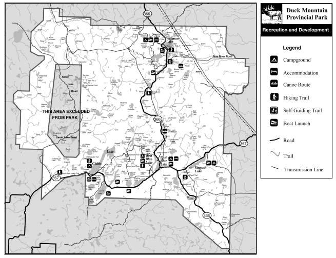
7 2. MANAGEMENT PLAN OVERVIEW This section, together with the accompanying General Land Use Framework, is intended to provide general direction for future park management initiatives and to assist in the resolution of park issues that are not specifically addressed in the management plan. 2.1 Introduction is an area of forested hills and interspersed lakes where the spirit of nature abounds. The park is a favorite destination for hunters, sport fishers and outdoor enthusiasts, and has a long tradition of resource use. The park ecosystem is managed to maintain viable populations of all native species in natural patterns of abundance and distribution within normal ranges of variation. Forest harvest activities operate within a framework of sustainable forest management, and forests are managed as ecosystems to conserve ecological integrity, long-term forest productivity and biological diversity. Recreational use is centered in the Wellman Lake, Singush Lake, Blue Lakes and Childs Lake areas of the park. These areas are designed to provide park visitors with adequate accommodations and services, while the remainder of the park is managed primarily to provide backcountry recreation opportunities in a natural setting. A park-wide trail system provides opportunities for trail-based recreation, with more extensive trail development near developed areas and fewer trails in more remote areas of the park. The Pine River area and the Roaring River/Shell River areas are managed as predominantly unmodified natural environments. The Laurie Lake area is reserved to provide future public use development options for the park, beyond the scope of this management plan. Duck Mountain has, and continues to be used by a number of First Nations communities for physical, spiritual, cultural and economic well being. Traditional uses include spiritual, social and recreational activities, as well as hunting, fishing, trapping and gathering. The management plan acknowledges and respects the treaty and Aboriginal rights of Aboriginal peoples to pursue traditional uses and activities within. 5

8 General Land Use Framework 6

9 2.2 Management Intent The management intent for major areas of the park is summarized below Backcountry LUC This 46,851-hectare area is protected from logging, mining or the development of oil, petroleum, natural gas or hydro-electric power. It is a generally unmodified natural environment that includes forests, prairie meadows and river valleys. The southern portion of the Backcountry LUC contains an extensive recreational trail system known as the Mossberry Trails. Within the Backcountry LUC, two Special Management Areas have been created to protect unique natural features and to provide recreational opportunities that depend on an undisturbed environment. The Roaring/Shell River Special Management Area is characterized by glacial spillways, hummocky stagnation moraines, and several prairie meadows, of which Jumper Plains is the best known. Associated features include salt licks, travertine deposits and mineral springs. Protected Areas Fact The glacial spillway in Duck mountain Provincial Park is an important feature in Manitoba s protected areas network. In the West Shell River valley, a unique combination of glacial deposits, regosolic soils and hummocky stagnation moraine can be found, the only one of its type in Natural Region 7. The Pine Creek Special Management Area is another largely unmodified natural area on the eastern edge of the Manitoba escarpment. Several tributaries merge into the Pine River to carry water down the escarpment to the surrounding lowlands. This scenic area provides important trout habitat. Special Management Areas (SMA) B Backcountry LUC Roaring/ Shell River SMA Pine River SMA RM RD A Resource Management LUC Recreational Development LUC Access LUC 7
10 2.3.2 Recreational Development LUC The Recreational Development LUC is comprised of four separate areas totaling 8,750 hectares. This area provides both extensive and intensive recreational opportunities. Campgrounds, lodges, cottage subdivisions and public facilities are focused in the Wellman, Singush, East Blue and Childs Lake areas Resource Management LUC This 86,719 hectare area accommodates both backcountry recreation and managed forest harvest. Hiking trails, interpretive trails and canoe routes are located in roadaccessible areas (near PTH 366 and 367). In more remote areas, fishers, hunters, hikers and other outdoor enthusiasts are the primary park users. Remote areas are accessed by both motorized and non-motorized means. Ecosystem based forest harvest strategies are employed in harvest areas and harvest is managed to minimize the impact on recreational activities and other resource values Access LUC Road access through the Backcountry LUC and access to adjoining gravel pits is provided by this LUC. The Access LUC accounts for 110 hectares or less than 1% of the park. 8

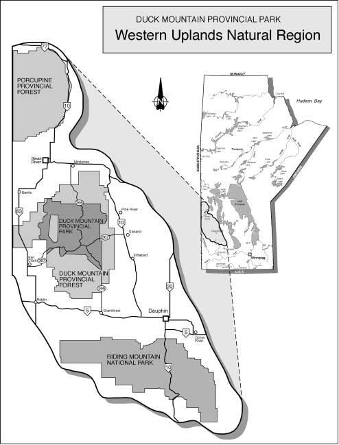
11 3. MANAGEMENT OBJECTIVES & GUIDELINES 3.1 Natural Values is situated in the Western Upland Natural Region. The park includes representative examples of several different landscape units, and as well as a number of locally significant sites and natural features. As part of a larger ecosystem, the natural values of are influenced by factors both within the park and in surrounding areas. Manitoba Conservation recognizes the role that Duck Mountain Provincial Park plays within this larger ecosystem, and is committed to working with partners and land managers in adjoining jurisdictions to ensure the health and viability of the area. The guidelines in the Natural Values portion of the management plan are directed at protecting the natural integrity of the park, while providing recreational opportunities and honoring existing resource commitments. 9
12 3.1.1 Wildlife Habitat and Special Areas Duck Mountain supports a diversity of natural communities and wildlife habitat. Wildlife management in the park is primarily the responsibility of the Manitoba Wildlife and Ecosystem Protection Branch. Parks and Natural Areas works in cooperation with Wildlife and Ecosystem Protection to manage and protect natural habitat and wildlife populations in the park. OBJECTIVE Protect the integrity of wildlife habitat and natural areas, and ensure that significant or unique natural features in the park are preserved. GUIDELINES Identify key natural areas Key natural areas will be identified on a central Duck Mountain Provincial Park database. This database will be updated as new information is obtained. Minimize human disturbances Recreational and resource use in significant natural areas (e.g. wintering areas, prairie meadows, mineral licks, travertine deposits, springs, canyons and valleys) will be managed to avoid excessive disturbances and fragmentation of park landscapes. Permit review Prior to the issuance of permits and licences for developments or activities, the application will be reviewed by resource managers to ensure that the proposed activity will not cause undue stress to natural areas and/or wildlife populations, or that negative impacts can be mitigated. 10


13 3.1.2 Vegetation Natural processes such as insects, fire and disease play an important role in the maintenance of natural areas. However, natural disturbances are often absent or suppressed in provincial parks due to the limited land base and the influence of human activities in and around the park area. To maintain the long-term viability of vegetative communities, strategies to enable or mimic natural disturbances under controlled conditions may be required. OBJECTIVE Develop a program to facilitate or imitate natural disturbances in areas of the park where these disturbances are known to be absent. GUIDELINES Vegetation Management Vegetation management strategies such as controlled burns, vegetation removal or planting, and pesticide use may be implemented to maintain or enhance significant natural features such as rare or unique plant species, vegetation communities and natural landscapes. Initial focus will be on selected prairie sites in the Shell/Roaring River Special Management Area. Review Requirement All vegetation management programs will be reviewed by resource managers in consultation with appropriate technical resources to assess its potential impact on factors such as wildlife, vegetation, water quality, historic sites and recreational values, and to identify an implementation plan. Control of Natural Disturbances Where there is no immediate threat to adjacent forestry or property values, natural disturbances such as insects and disease may be permitted to proceed, subject to consultation with Manitoba Forestry. Fire Management Wildfires will generally be suppressed as per Manitoba Conservation's Fire Program Primary Protection Zone guidelines. Fire management plans may be developed to protect specific sensitive areas of the park. 11
14 3.1.3 Water The waters of are one of the park's most valued features. Activities such as forest harvest and recreational development must be carefully managed to protect water quality both within the park and downstream, beyond the park boundaries. Siltation, downstream flooding, and non-point source pollution are serious issues which must be considered into all resource management strategies. Nutrient loading from pit privies and septic fields, intensive shoreline development, inappropriate use of pesticides and fertilizers, and spills of fuels and contaminants can also affect water quality and must be handled with care. OBJECTIVES Maintain high standards of water quality and natural patterns of stream flow. GUIDELINES Water Quality Monitoring Water quality sampling will be conducted at selected water bodies within the park to establish baseline water quality data. Initial testing will focus on lakes with cottage or recreational development. Monitoring to assess the impacts of other activities such as forest harvest may be conducted as needed or as issues arise. Sewage Disposal Pump-out sewage holding tanks generally provide the highest level of protection to surface water and groundwater. Conversion to septic holding tanks is planned as follows: Properties with an existing and approved sewage handling system will be permitted to retain their system until such time as upgrading is required. Properties needing or wishing to upgrade their sewage system will be required to install a pump-out sewage holding tank. The installation of new septic fields or the upgrading of existing fields will not be permitted. Lake Water Levels Lake water levels will be allowed to fluctuate naturally. Manipulation of water levels for recreational purposes other than fish enhancement will not be permitted. Flood control structures operated by Manitoba Water Branch are discussed below; structures for fisheries enhancement purposes in section Flood Control Structures Manitoba Water Branch control structures at Beaver Lake, Pine River Lake, Shanty Lake and Pine River will continue to be operated for flood control purposes. Public Education In cottage subdivision areas, Manitoba Parks will work with local cottaging associations and other partners to promote responsible shoreline development strategies aimed at protecting water quality. 12
15 3.1.4 Fisheries The lakes and streams of Duck Mountain host a variety of aquatic species, both native and introduced. Fisheries management in the park has focused on stocking programs to maximize recreational angling opportunities. While stocking will continue to be an essential part of this fishery, protecting the integrity of aquatic ecosystems is also an important priority. Manitoba Fisheries Branch oversees the fisheries management program in the park, and there is a high level of user involvement through local fish enhancement groups. OBJECTIVE Protect the integrity of aquatic ecosystems while providing a diversity of angling opportunities. GUIDELINES Stocking Prior to implementing new stocking initiatives (i.e. lakes that have not been stocked for five years or more), resource managers will review the potential impact of stocking on factors such as wildlife, vegetation, historic sites, access, recreational and commercial use. Special Management Zone Stocking will not be permitted in the Shell/Roaring River Special Management Area. Control Structures for Fisheries Management Control structures for fisheries management purposes will not be permitted in the Backcountry LUC. In other areas of the park, controls structures must not alter water quantities (flows and lake-levels) such that water quality or other uses of the lake or stream are impaired. Use of Fish Toxicants Use of fish toxicants for fisheries management purposes will not be permitted, except in exceptional circumstances (e.g. to eradicate an unwanted species that has been introduced to a water accidentally or intentionally without approval). 13
16 14
. About 61% of the park lies within this LUC, but only a small percentage of this area is harvested each year.")


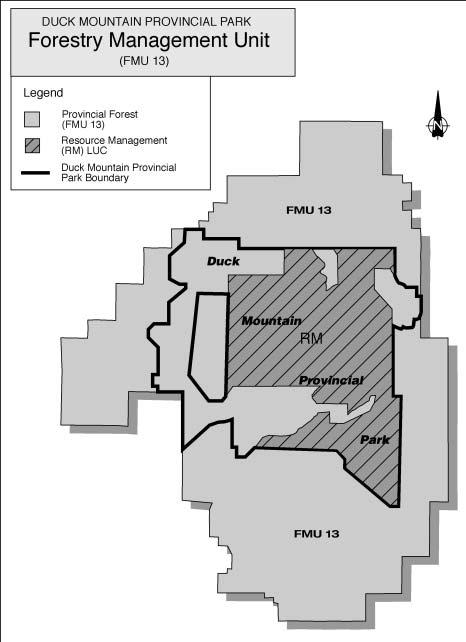
17 3.1.5 Forestry is part of a larger forestry unit known as Forest Management Unit (FMU) 13, which is located in Forest Management License (FML) Area 3. Commercial logging occurs in the park in the Resource Management Land Use category (LUC). About 61% of the park lies within this LUC, but only a small percentage of this area is harvested each year. Manitoba Conservation oversees forestry operations in the park. Planning and implementation of forest harvest activities in areas approved for harvest is primarily the responsibility of Louisiana Pacific Canada Ltd., under licence from the Province of Manitoba. In, cut blocks are allocated annually to private quota holders who carry out the logging in the park. Forestry activities are determined through processes such as Forest Management and Environmental Licensing. Public input is achieved through Forest Management Plan and Annual Operating Plan Reviews. OBJECTIVE Accommodate environmentally sound forest harvest activities in areas of the park designated as Resource Management LUC. GUIDELINES Forestry Classifications For the purpose of Manitoba s Forest Resource Inventory, Duck Mountain Provincial Park has been classified as follows: a) Backcountry LUC - closed b) Recreational Development LUC - restricted (park management purposes only) c) Resource Management LUC - open Forest Management Forests are managed to conserve ecological integrity, long-term productivity and biological diversity. Parks and Natural Areas will work with Manitoba Forestry, resource managers and the local forest industry to develop and implement ecosystem based management strategies for forest harvest and renewal and to manage forest harvest to minimize its impact on recreational activities and other resource values. 15
 Access road limitations (e.g. road in and close out, no circle routes). iii) Road closure and crossing provisions.")
18 Special Conditions for Cutting in Park Special conditions may be applied to cutting plans within Provincial Parks including, but not limited to: i) Hauling and operation restrictions (e.g. appropriate dates or times of day may be prescribed). ii) Access road limitations (e.g. road in and close out, no circle routes). iii) Road closure and crossing provisions. iv) Distances from identified natural features, historic sites and recreation areas. Buffers As part of standard buffer requirements, additional buffers or management strategies may be imposed to protect recreational and natural park values such as: i) Recreation areas and facilities. ii) Viewscapes from park roadways, trails, recreation areas, campgrounds, cottage subdivisions, viewing towers and viewpoints, including views which extend beyond the park (eg. Baldy Mountain). iii) Significant natural or cultural sites or features. iv) Wildlife and wildlife habitat, in consultation with the Wildlife and Ecosystems Protection Branch. Forest Access Roads Strategies will be employed to minimize new road construction and duration of operation. Where possible, existing routes of access will be utilized. Where necessary, roads will be gated to restrict public use of forest access roads. Entire roads, portions of roads or water crossings will generally be decommissioned when forestry access beyond these points is no longer required. 16
19 3.1.6 Non-Timber Forest Products The harvest of non-timber forest products is a wide and growing sector of commercial use. On a small scale, the harvest of non-timber forest products may have little impact on the park landscape. On a larger scale, significant changes in species composition, disturbances to natural landscapes and conflicts with other park users can occur. The term "non-timber forest products" is generally used to refer to marketable plant products, such as leaves, needles, branches, stems, bark, skin, sap, resins, oils, roots, fruit, mushrooms, cones, seeds and flowers of trees and plants. Other potentially marketable, but otherwise unregulated, animal and mineral products are also addressed in this section. Harvest of non-timber forest products by aboriginal people for domestic purposes, and licenced activities such as logging, fishing, hunting, trapping, gravel and mineral extraction are administered separately by various pieces of legislation and are not part of this issue. OBJECTIVES Manage the commercial harvest of selected non-timber forest products in a manner that does not compromise recreational or other resource values. GUIDELINES Plant Harvest Commercial harvest of plant products may be permitted in the Resource Management and Access LUCs only, subject to the following limitations: Harvest is limited to species ranked by the Manitoba Conservation Data Centre as "apparently secure" (rank 4) or "demonstrably secure" (rank 5) on a province-wide basis. Harvest of species found in low concentrations or non-continuous distributions in the park, and harvest that destroys the plant (e.g. seneca snakeroot, sarsaparilla, calamus), will not be permitted. Additional harvesting guidelines and/or assessment of royalties may be applied as determined by the Province of Manitoba. 17
20 Permit Requirements for Plant Harvest Injury to park lands 8(1)Except under the authority of an Act of the Legislature or the written authorization of an officer, no person shall deface, injure, destroy or remove any object in a provincial park whether created by natural means or otherwise. 8(2) Notwithstanding subsection (1), (a) domestically cultivated flowers and vegetables for personal use; (b) annually picked wild fruits and berries; (c) surface water taken for per sonal consumption by means other than a plumbing system; may be removed from a provincial park. Source: Manitoba Regulation P20-141/96. Parks and Natural Areas Branch will review proposals for the commercial harvest of qualifying plant products in consultation with the Manitoba Conservation Data Centre and Manitoba Forestry. If general requirements are met, the following minimum permit conditions will apply: Quantities and area to be harvested will be specified on the permit. Permits will be issued on a one-time or annual basis only (no tenure). Permits will be issued only for areas where there is no conflict with other park users. Harvesting methods must not cause physical damage to the park environment. No new trails, roads, access routes, temporary or built facilities will be permitted. Propagation or Cultivation of Non-Timber Forest Products Propagation or cultivation of non-timber forest products (plant or animal) is not allowed within the park. Harvest for Scientific, Educational or Park Management Purposes Applications for the harvest of non-timber forest products for scientific or educational purposes (plant, animal or mineral) will be considered on a caseby-case basis. Harvest of non-timber forest products for park management purposes may be permitted. Collection of Shed Antlers Collection of shed antlers may be permitted throughout the park, however the written authorization of an officer is required to remove them from the park. Harvest Restricted Permits will not be issued for: Plants or plant products from species ranked by Manitoba Conservation Data Centre as rank 1 (very rare), rank 2 (rare) or rank 3 (uncommon) on a global or provincial basis, or species that are otherwise restricted or regulated. Animals or animal parts other than shed antlers. Animal species not protected by Legislation. Mineral products such as decorative rocks and stones. Bait fish. Wild rice. 18

21 3. MANAGEMENT OBJECTIVES & GUIDELINES 3.2 Recreation and Historic Resources offers a range of recreational opportunities including camping, hunting, fishing, swimming, cottaging and trail-based activities. It is a place where park visitors can experience solitude, tranquility and closeness to nature. Accessible backcountry areas provide opportunities for challenge and self-reliance in an unspoiled environment qualities that are valued and increasingly rare in today s world. Over time, however, growing numbers of park visitors and an ever-expanding variety of recreational pursuits could change the character of the park as it is now known. Guidelines respecting levels and types of activities are needed to ensure that the park retains its character as a largely undeveloped but relatively accessible natural area for future generations. The guidelines in the Recreation and Historic Resources portion of the management plan are directed at providing appropriate recreational opportunities, while protecting the natural integrity of the park and honoring existing resource commitments. 19
22 3.2.1 Trails has a well-established network of trails for both motorized and non-motorized use. These trails provide excellent opportunities for trail-based recreation and are an important part of the recreational experience at Duck Mountain. Trails are routed to avoid habitat fragmentation, damage to sensitive areas, and disturbances to wildlife and other park users. In general, motorized trails have a more significant impact on the park environment than do non-motorized trails, although both can have an effect. Issues of soil compaction and displacement, noise, removal of vegetation cover, air pollution and aesthetic loss due to scarring of landscapes have been identified. Impacts on wildlife and nesting birds through destruction of habitat, direct harassment of animals and behavioral modifications associated with vehicle use have also been cited. Management strategies to minimize these disturbances are crucial. OBJECTIVE Provide a range of trail based recreation opportunities that will enable park visitors to view and appreciate the natural park environment. GUIDELINES Trail System Review A park trails plan will be prepared which will incorporate existing trails or routes for hiking, interpretation, cross-country skiing, canoeing and ATV use, as well as snowmobile trails operated in cooperation with the Snowmobile Association of Manitoba. Opportunities for departmental, public and stakeholder participation in plan development will be provided. All-Terrain Vehicles (ATVs) A prescribed ATV trail system will be phased in as development and maintenance funds permit. The trails will provide opportunities to tour the park by ATV and will be designed to minimize impact on the park environment. In prescribed trail areas, ATVs will be required to travel on prescribed trails. In areas of the park where prescribed ATV trails have not been implemented, ATVs will be restricted to existing well-traveled trails. Trail development will be subject to appropriate environmental assessment and review. Implementation will begin in the Recreational Development LUC, followed by the Backcountry, Resource Management and Access LUCs. ATV use will be focused in appropriate areas of the park. Trails will not be designated in sensitive areas such as wetlands, riparian areas, river banks and soft terrain. Routes in remote backcountry areas (e.g. the Shell River/Roaring River and the Pine River Special Management Areas) will be minimized to provide a non-motorized atmosphere in portions of the park. 20
23 New Trail Development New trail development will be minimal and will be routed to minimize impact on natural areas. Proposals for new trail developments or activities will be reviewed to assess potential impact on factors such as vegetation, wildlife habitat and populations, erosion and environmental damage, existing trail density, distance from recreation areas, cultural or historic sites, and potential for user conflicts. Existing trails will be utilized where possible. Trail Use Restricted Use of off-road vehicles other than ATVs and snowmobiles will not be permitted in the park. Secondary non-motorized activities such as cycling, horseback riding, or travel by horse and wagon may be accommodated on the recreational trail system at the discretion of the Park Manager. ATV Use for Work Purposes Manitoba Conservation may authorize travel off trails for park operation and maintenance purposes or under authority of a permit issued to a commercial operator or registered trapline holders, or for educational purposes, scientific research or reason deemed to be in the public interest. ATV/Snowmobile Derbies Requests for special events such as ATV and snowmobile derbies will be assessed based on potential for environmental damage and disturbance to wildlife and other park users. ATV derbies will generally not be permitted in the park; winter snowmobile derbies will not be permitted in the Special Management Areas. Definitions ATV An all-terrain vehicles (ATV) is defined under The Off-Road Vehicles Act as an off-road vehicle that operates or travels on three or more low-pressure tires; has a seat designed to be straddled by the operator of the vehicle; and has handlebars for steering the vehicle (The Off-Road Vehicles Act, section 1(1)). Well-traveled trail A well-traveled trail means an existing trail that is well established and regularly used by all-terrain vehicles, but does not include roads used by licensed vehicles such as cars and trucks. Public Education Manitoba Conservation will work with ATV and snowmobile organizations to promote environmentally and socially responsible motorized recreation in the park. Decommissioning of Trails Manitoba Conservation may close trails to enable rehabilitation of natural areas, reduce trail density or ensure public safety. 21
24 3.2.2 Hunting and Fishing has long been a popular destination for elk, deer, moose and black bear hunters. Seasons for upland and migratory game birds and gray wolf are also held in the park. Fishers are offered a wide diversity of angling opportunities in the park for native and non-native species, both natural and stocked. Motor prohibitions, applicable to all park users, are in place on a number of these lakes to provide a non-motorized angling experience. The Wildlife and Ecosystem Protection Branch and the Fisheries Branch manages hunting and fishing in the park, in accordance with provincial regulations and policy. To enhance the recreational experience for hunters and fishers, the following park-specific guidelines respecting camping and boat caching are in effect. OBJECTIVE Accommodate hunters and fishers in the park by designating backcountry camping areas for licenced big game hunters, and a boat caching area for sport fishers and other recreationists. GUIDELINES Camping in designated areas (37) No person shall camp in a provincial park except in an area designated for that purpose by the minister. Source: Manitoba Regulation 141/96. Camping by Licenced Big Game Hunters Licenced big game hunters may be permitted to camp adjacent to: Designated routes* Provincial road right-of ways More than one kilometre from an improvement or development such as a road-accessible lake, interpretive trail, site or facility, or active timber harvest area. Camping will not be permitted adjacent to campgrounds, boat launches or in locations deemed inappropriate by a Natural Resource Officer. Vehicle access to backcountry camping areas is subject to Wildlife and Ecosystem Protection Branch regulations regarding vehicle use in a designated route area. * Designated routes are roads and trails specifically identified for hunting purposes as Designated Routes as outlined in the annual Manitoba Hunting Guide. Camping Dates Restricted Camping by licenced big game hunters will be permitted during the period commencing 2 days prior to the opening of the hunting season until the Sunday following the close of the season for which he/she is licenced. Roadside camping adjacent to provincial road right-of-ways will not be permitted until the Tuesday following the September long weekend. 22

25 Camping Restrictions The following conditions will apply: No-trace camping principles are in effect; no services or facilities will be provided. Campers may not cut new trails or obstruct existing trails or roadways. Open fires are prohibited. Additional conditions may be specified at the discretion of a Natural Resource Officer. Private Boat Caches Cached boats will be permitted in designated locations on non-road accessible lakes. Caches must not obstruct paths or impede launch areas or shorelines. The name and address of the owner must be permanently displayed on the boat. Boats with no identifiable identification or stored improperly may removed by Manitoba Conservation. Strategy Subject to Revision If warranted by environmental conditions, high levels of use or other concerns, alternative management strategies such as limitations or permitting requirements on motor use, boat caching or backcountry camping may be implemented at a future date. 23
26 3.2.3 Outfitting Commercial outfitters operate within the park to provide a variety of recreational experiences, including hunting. has long been a popular destination for elk, deer, moose and black bear hunters. Seasons for upland games, migratory game birds and gray wolf are also held in the park. is located in Game Hunting Area 18. The Wildlife and Ecosystem Protection Branch manages commercial outfitters operating within the park, and outfitters are subject to applicable provincial regulations and guidelines. In addition, the following park-specific guidelines respecting outfitting in the park are in effect: OBJECTIVE Accommodate commercial outfitting activities while keeping remote areas of the park in a natural and undisturbed state. GUIDELINES Outcamps and Tent Camps The establishment of commercial outcamps will not be permitted in the park, and no new commercial tent camps will be permitted. Existing commercial tent camps may continue to operate subject to the conditions below. Relocation of tent camps to an area outside of the park may be investigated should an appropriate opportunity arise. Existing Tent Camps Tent camps held under the authority of an existing licence may be erected two weeks prior to the season for which it will be used. Tent camps must be removed within two weeks of the season's end or when no longer being used on a continual basis (i.e. after two weeks of disuse). Tent camp permits will be issued on an annual basis. Outfitters' Equipment Left in Park Equipment such as tree stands and blinds may be set up in the park not earlier than two weeks prior to the season for which it will be used. Equipment must be removed within two weeks of the season s end or when no longer being used on a continual basis (i.e. after two weeks of disuse). Permanent structures will not be permitted. Identification of Equipment Equipment left in the park must be clearly identified with the name and address of the owner, and may be removed by Manitoba Conservation if in contravention of these guidelines. Manitoba Conservation is not responsible for loss or damage to equipment. Commercial Boat Caches Commercial boat caches may be permitted. 24
27 3.2.4 Commercial Development Commercial facilities such as rental cabins, stores, restaurants and gas stations are located at Wellman, East Blue and Childs lakes. These three centres are in proximity to the most heavily used recreational areas in the park. This level of development is considered appropriate and no additional development centres have been identified in this plan. OBJECTIVE Accommodate commercial development at existing development nodes in the Wellman, East Blue, and Childs Lake areas. GUIDELINES General Development Criteria Proposals for additional development within existing development nodes will be evaluated using the following criteria: a) Development proposals must be presented as part of an integrated overall development plan for the site and must demonstrate suitability for a park setting. b) Proposals must be consistent with the natural and cultural values of the park. c) Proposals must demonstrate a direct benefit to the park and park uses, and must be compatible with existing and adjacent site use. d) Proposals must demonstrate economic viability, and will be subject to appropriate review and applicable environmental assessment. 25
28 26


")
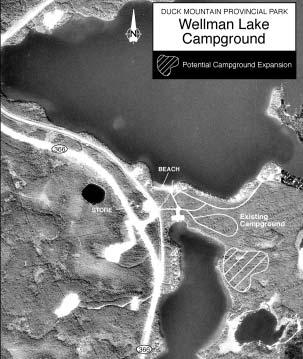
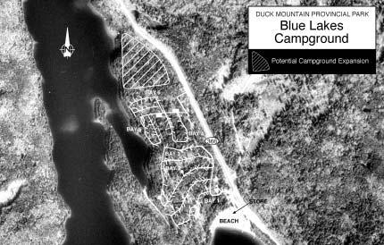
29 3.2.5 Camping Occupancy rates at transient campgrounds in the park are generally high, with average weekend occupancy at Wellman Lake in the 50-80% range or higher. Campground occupancy at Blue Lake is also high and is projected to increase. Backcountry camping is permitted at designated campsites only, except as provided for licenced big game hunters as outlined in section of this plan. Designated backcountry camping sites are located on the Mossberry Trail and on the Chain Lakes canoe route. OBJECTIVE Provide additional camping opportunities at Wellman and Blue Lakes. GUIDELINES Campground Expansion Sites for future campground expansion will be identified at the following two locations: Wellman Lake (near northeast shore of Glad Lake) Blue Lake (north of existing campground) Group Use Area A site for a new group camping area will be investigated at Wellman Lake (east of existing campground). Time Frame Development of expanded facilities is subject to annual budget allotments and will proceed when feasible. 27
30 28


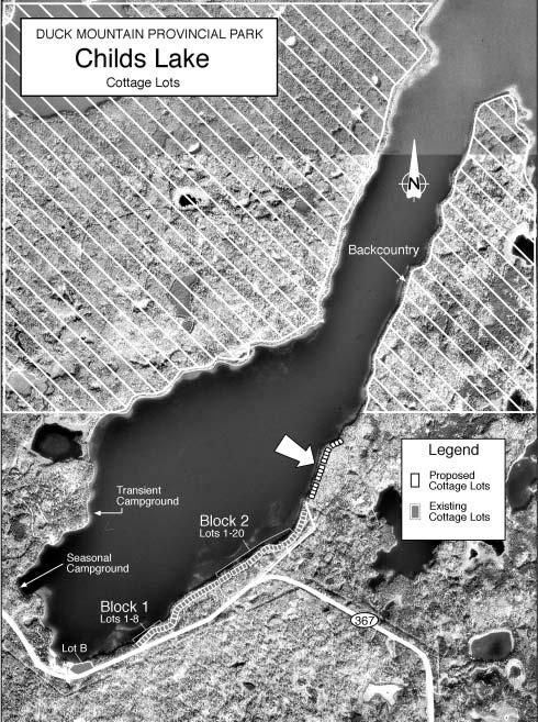
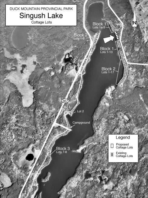
31 3.2.6 Cottaging Over the past several years, there has been demand for new cottaging opportunities in the park. New cottage lot development can be accommodated in a number of ways. One is by providing additional cottaging opportunities of already-developed lakes, and another is to open currently undeveloped lakes to development. By focussing new development in existing developed areas, recreational opportunities on accessible, undeveloped lakes can be preserved, and the generally undeveloped character of the park will be maintained. OBJECTIVE Provide additional cottaging opportunities at Singush and Childs lakes. GUIDELINES New Cottage Development New cottage development will be permitted on existing developed lakes only. The feasibility of additional lake-front cottage lots on Singush and Childs lakes will be investigated. Existing back-tier cottage lots at Wellman Lake will continue to be made available. Development Criteria New cottage construction will be in accordance with existing guidelines, policies and regulations respecting cottage development. At Singush Lake, hydro development costs incurred by existing cottage owners will factored into new development costs. See section regarding water quality monitoring and sewage disposal requirements. 29
32 30
33 3.2.7 Historic Sites has a long history of human use by indigenous people and later by trappers, hunters, loggers and recreationists. Duck Mountain's role in the history of western Canada is evident in the remains of historic buildings, logging and work camp sites, fire towers, historic trails, tent rings, arrowheads, poles and Indian campsites. Most of these sites remain unmarked. The Baldy Mountain Hiking Trail, which follows the historic Central Trail from Grandview, leads to an old cabin and stable. Interpretive signs at Baldy Mountain portray the use of Duck Mountain's resources through the ages. Various inventories of these sites have been compiled, but no one source contains all available information. To ensure that these areas are not inadvertently damaged by recreational or resource use in the park, and to facilitate the recording of newly discovered artifacts in the park, a process for information collection and review is required. OBJECTIVES Develop a process to address the potential impact of recreational and resource use on culturally and historically significant areas of the park. GUIDELINES Identify Key Historic Sites Key historic sites and culturally significant areas will be identified on a central historic sites database. The database will be coordinated with archaeological site information compiled by Manitoba Culture, Heritage and Tourism and will be updated as new information is obtained. Permit Review Prior to the issuance of permits and licences for new developments or activities, available inventories of historic sites will be consulted to ensure that known sites are not inadvertently damaged, or that negative impacts can be mitigated. Minimize Human Disturbances Recreational and resource use in key historic sites and culturally significant areas will be managed to avoid sensitive areas and to minimize site degradation and disturbance. Where practical, historic trails and routes will be utilized in areas where new trail development is proposed, as a means of providing new interpretative opportunities. 31

34 For further information please contact: Management Plan Parks and Natural Areas Branch Manitoba Conservation Box 53, 200 Saulteaux Crescent Winnipeg, Manitoba R3J 3W3 Phone: Toll free: Fax:
Clearwater Lake Provincial Park. Draft Management Plan
 Clearwater Lake Provincial Park Draft Management Plan Clearwater Lake Provincial Park Draft Management Plan Table of Contents 1. Introduction... 3 2. Park History... 4 3. Park Attributes... 4 3.1 Location/Access...4
MANAGEMENT DIRECTION STATEMENT June, 1999
 Thompson River District MANAGEMENT DIRECTION STATEMENT June, 1999 for Roche Lake Provincial Park Ministry of Environment Lands and Parks BC Parks Division Table of Contents I. Introduction A. Setting
Birch Point Provincial Park. Management Plan
 Birch Point Provincial Park Management Plan 2 Birch Point Provincial Park Table of Contents 1. Introduction... 3 2. Park History... 3 3. Park Attributes... 4 3.1 Natural... 4 3.2 Recreational... 4 4. Park
Marchand Provincial Park. Management Plan
 Marchand Provincial Park Management Plan 2 Marchand Provincial Park Table of Contents 1. Introduction... 3 2. Park History... 3 3. Park Attributes... 4 3.1 Natural... 4 3.2 Recreational... 4 3.3 Additional
Whitemouth Falls Provincial Park. Draft Management Plan
 Whitemouth Falls Provincial Park Draft Management Plan Whitemouth Falls Provincial Park Draft Management Plan Table of Contents 1. Introduction... 3 2. Park History... 3 3. Park Attributes... 4 3.1 Natural...
Beaver Creek Provincial Park. Management Plan
 Beaver Creek Provincial Park Management Plan 2 Beaver Creek Provincial Park Table of Contents 1. Introduction... 3 2. Park History... 3 3. Park Attributes... 4 3.1 Natural... 4 3.2 Recreational... 4 4.
Wallace Lake Provincial Park. Management Plan
 Wallace Lake Provincial Park Management Plan 2 Wallace Lake Provincial Park Table of Contents 1. Introduction... 3 2. Park History... 3 3. Park Attributes... 4 3.1 Natural... 4 3.2 Recreational... 4 4.
Sand Lakes Provincial Park. Draft Management Plan
 Sand Lakes Provincial Park Draft Management Plan 2 Sand Lakes Provincial Park Table of Contents 1. Introduction... 3 2. Background... 3 3. Park Purpose... 5 4. Park Management Guidelines... 6 Appendix...
Numaykoos Lake Provincial Park. Management Plan
 Numaykoos Lake Provincial Park Management Plan 2 Numaykoos Lake Provincial Park Table of Contents 1. Introduction... 3 2. Background... 3 3. Park Purpose... 5 4. Park Management Guidelines... 6 Appendix...
Wallace Lake Provincial Park. Draft Management Plan
 Wallace Lake Provincial Park Draft Management Plan Wallace Lake Provincial Park Draft Management Plan Table of Contents 1. Introduction... 3 2. Park History... 3 3. Park Attributes... 4 3.1 Natural...
Rocky Lake Provincial Park. Draft Management Plan
 Rocky Lake Provincial Park Draft Management Plan Rocky Lake Provincial Park Draft Management Plan Table of Contents 1. Introduction... 3 2. Park History... 3 3. Park Attributes... 4 3.1 Location/Access...4
MANAGEMENT DIRECTION STATEMENT June, 1999
 Thompson River District MANAGEMENT DIRECTION STATEMENT June, 1999 for Clearwater River Corridor (Addition to Wells Gray Park) Ministry of Environment Lands and Parks BC Parks Division ii Table of Contents
Sasagiu Rapids Provincial Park. Draft Management Plan
 Sasagiu Rapids Provincial Park Draft Management Plan 2 Sasagiu Rapids Provincial Park Table of Contents 1. Introduction... 3 2. Background and Park Attributes... 3 2.1 Park History.... 3 2.2 Natural Features...
Watchorn Provincial Park. Management Plan
 Watchorn Provincial Park Management Plan 2 Watchorn Provincial Park Table of Contents 1. Introduction... 3 2. Park History... 3 3. Park Attributes... 3 3.1 Natural... 4 3.2 Recreational... 4 3.3 Additional
A GUIDE TO MANITOBA PROTECTED AREAS & LANDS PROTECTION
 A GUIDE TO MANITOBA PROTECTED AREAS & LANDS PROTECTION Manitoba Wildands December 2008 Discussions about the establishment of protected lands need to be clear about the definition of protection. We will
South Atikaki Provincial Park. Draft Management Plan
 South Atikaki Provincial Park Draft Management Plan South Atikaki Provincial Park Draft Management Plan Table of Contents 1. Introduction... 3 2. Park History... 3 3. Park Attributes... 3 3.1 Natural...
Pembina Valley Provincial Park. Draft Management Plan
 Pembina Valley Provincial Park Draft Management Plan 2 Pembina Valley Provincial Park Table of Contents 1. Introduction... 3 2. Park History... 3 3. Park Attributes... 3 3.1 Natural... 3 3.2 Recreational...
As outlined in the Tatshenshini-Alsek Park Management Agreement, park management will:
 Management Strategy General Strategy The priority management focus for the park is to ensure that its internationally significant natural, cultural heritage and recreational values are protected and that
Pinawa Provincial Park. Draft Management Plan
 Pinawa Provincial Park Draft Management Plan Pinawa Provincial Park Draft Management Plan Table of Contents 1. Introduction... 3 2. Park History... 3 3. Park Attributes... 4 3.1 Natural... 4 3.2 Recreational...
Norris Lake Provincial Park. Draft Management Plan
 Norris Lake Provincial Park Draft Management Plan 2 Norris Lake Provincial Park Table of Contents 1. Introduction... 3 2. Park History... 3 3. Park Attributes... 4 3.1 Natural... 4 3.2 Recreational...
Nakina Moraine Provincial Park. Interim Management Statement. Ontario. Ministry of Natural Resources
 Nakina Moraine Provincial Park Interim Management Statement Ontario Ministry of Natural Resources 1999, Queen's Printer for Ontario Printed in Ontario, Canada Additional copies of this publication can
Little Limestone Lake Provincial Park. Draft Management Plan
 Little Limestone Lake Provincial Park Draft Management Plan Little Limestone Lake Provincial Park Draft Management Plan Table of Contents 1. Introduction... 3 2. Background... 3 3. Planning context...
5.0 OUTDOOR RECREATION OPPORTUNITIES AND MANAGEMENT
 5.0 OUTDOOR RECREATION OPPORTUNITIES AND MANAGEMENT 5.1 Introduction This section describes the range of recreational activities that currently take place in Marble Range and Edge Hills Parks, as well
OMINEACA PROVINCIAL PARK
 OMINEACA PROVINCIAL PARK AND PROTECTED AREA PURPOSE STATEMENT AND ZONING PLAN March 2003 OMINECA PROVINCIAL PARK AND PROTECTED AREA Purpose Statement and Zoning Plan Omineca Park and Omineca Protected
Portage Spillway Provincial Park. Draft Management Plan
 Portage Spillway Provincial Park Draft Management Plan 2 Portage Spillway Provincial Park Table of Contents 1. Introduction... 3 2. Park History... 3 3. Park Attributes... 4 3.1 Natural... 4 3.2 Recreational...
Seager Wheeler Lake. Representative Area. -- Concept Management Plan --
 Seager Wheeler Lake Representative Area -- Concept Management Plan -- Saskatchewan Environment and Resource Management January, 1999 Saskatchewan s Representative Areas Network Program The Government of
PROUDLY BRINGING YOU CANADA AT ITS BEST. Management Planning Program NEWSLETTER #1 OCTOBER, 2000
 PROUDLY BRINGING YOU CANADA AT ITS BEST VUNTUT NATIONAL PARK Management Planning Program NEWSLETTER #1 OCTOBER, 2000 INTRODUCTION This newsletter launches the development of the first management plan for
Grand Rapids Provincial Park. Draft Management Plan
 Grand Rapids Provincial Park Draft Management Plan Grand Rapids Provincial Park Draft Management Plan Table of Contents 1. Introduction... 3 2. Park History... 3 3. Park Attributes... 4 3.1 Location/Access...4
Yard Creek Provincial Park. Management Plan
 Yard Creek Provincial Park Management Plan Draft January 2010 Yard Creek Provincial Park Management Plan Approved by: telàlsemkin/siyam/chief Scott Benton Bill Williams Squamish Executive Director ation
APPENDIX. Alberta Land Stewardship Act AMENDMENTS TO THE SOUTH SASKATCHEWAN REGIONAL PLAN
 APPENDIX Alberta Land Stewardship Act AMENDMENTS TO THE SOUTH SASKATCHEWAN REGIONAL PLAN 1 All references to Alberta Environment and Sustainable Resource Development, Environment and Sustainable Resource
Criddle/Vane Homestead Provincial Park. Management Plan
 Criddle/Vane Homestead Provincial Park Management Plan 2 Criddle/Vane Homestead Provincial Park Table of Contents 1. Introduction... 3 2. Park History.... 3 3. Park Attributes.... 4 3.1 Natural.... 4 3.2
Criddle/Vane Homestead Provincial Park. Draft Management Plan
 Criddle/Vane Homestead Provincial Park Draft Management Plan 2 Criddle/Vane Homestead Provincial Park Table of Contents 1. Introduction... 3 2. Park History.... 3 3. Park Attributes.... 3 3.1 Natural....
Appendix A BC Provincial Parks System Goals
 Appendix A BC Provincial Parks System Goals The British Columbia Provincial Parks System has two mandates: To conserve significant and representative natural and cultural resources To provide a wide variety
FINGER-TATUK PROVINCIAL PARK
 FINGER-TATUK PROVINCIAL PARK PURPOSE STATEMENT AND ZONING PLAN March 2003 FINGER-TATUK PROVINCIAL PARK Purpose Statement and Zoning Plan Finger-Tatuk Provincial Park is 17,151 ha in size. It includes the
ONE ISLAND LAKE PROVINCIAL PARK Purpose Statement and Zoning Plan
 ONE ISLAND LAKE PROVINCIAL PARK Purpose Statement and Zoning Plan Primary Role The primary role of One Island Lake Provincial Park is to provide recreational opportunities to regional and residential area
Outdoor Recreation Opportunities Management
 Outdoor Recreation Opportunities Management Introduction The natural features of Height of the Rockies and Elk Lakes provincial parks provide a wide variety of outdoor recreational activities. However,
Rule Governing the Designation and Establishment of All-Terrain Vehicle Use Trails on State Land
 Rule Governing the Designation and Establishment of All-Terrain Vehicle Use Trails on State Land 1.0 Authority 1.1 This rule is promulgated pursuant to 23 V.S.A. 3506. Section 3506 (b)(4) states that an
2.1 Physical and Biological Description Matabitchuan River Watershed
 2.1 Physical and Biological Description Watershed 2.1.1 Physical Description The system watershed has a total area of about 933 km 2 and is a tributary system to Lake Temiskaming and the Ottawa River Drainage
Connie Rudd Superintendent, Black Canyon of the Gunnison National Park
 National Park Service U.S. Department of the Interior Black Canyon of the Gunnison National Park and Curecanti National Recreation Area Information Brochure #1 Wilderness and Backcountry Management Plan
KANANASKIS COUNTRY PROVINCIAL RECREATION AREAS MANAGEMENT PLAN DRAFT TERMS OF REFERENCE - November 20, 2007
 KANANASKIS COUNTRY PROVINCIAL RECREATION AREAS MANAGEMENT PLAN DRAFT TERMS OF REFERENCE - November 20, 2007 BACKGROUND There are 42 Provincial Recreation Areas (PRAs) within Kananaskis Country located
MANAGEMENT DIRECTION STATEMENT March 2003
 Skeena Region MAAGEMET DIRECTIO STATEMET March 2003 for Meziadin Lake Provincial Park Ministry of Water, Land and Air Protection Environmental Stewardsh Division This page left blank on purpose ii Table
SUMMER VILLAGE OF SILVER SANDS. Municipal Development Plan
 SUMMER VILLAGE OF SILVER SANDS Municipal Development Plan Bylaw 253-2014 Adopted August 22, 2014 Summer Village of Silver Sands Municipal Development Plan Bylaw No. 253-2014 Page 2 1 INTRODUCTION 1.1 SETTING
Appendix 1: Best Management Practices For Hang Gliding and Paragliding in Jasper National Parks
 Appendix 1: Best Management Practices For Hang Gliding and Paragliding in Jasper National Parks Name of Best Management Practice Best Management Practices for Hang Gliding and Paragliding in Jasper National
Stuart River Provincial Park Purpose Statement and Zoning Plan
 Stuart River Provincial Park Purpose Statement and Zoning Plan Stuart River Provincial Park protects three-quarters of the 110 kilometer long Stuart River corridor between Stuart Lake and the Nechako River.
Winnipeg Beach Provincial Park. Draft Management Plan
 Winnipeg Beach Provincial Park Draft Management Plan 2 Winnipeg Beach Provincial Park Table of Contents 1. Introduction... 3 2. Park History... 3 3. Park Attributes... 4 3.1 Natural...4 3.2 Recreational...4
Public Review on Proposed Changes to Trapping Policy
 Public Review on Proposed Changes to Trapping Policy in Manitoba s Provincial Parks and Other Crown Lands With Recreational Developments In December 2012, two dogs were killed in traps while they were
Theme: Predominately natural/natural appearing; rustic improvements to protect resources. Size*: 2,500 + acres Infrastructure**:
 Recreation Opportunity Spectrum (ROS) Classes The Recreation Opportunity Spectrum (ROS) provides a way to describe the variations in the degree of isolation from the sounds and influences of people, and
2.0 PARK VISION AND ROLES
 2.0 PARK VISION AND ROLES 2.1 Significance in the Protected Area System Marble Range and Edge Hills provincial parks protect 6.8% of the Pavillion Ranges Ecosection, which is located in the Southern Interior
Chapter 9: National Parks and Protected Areas
 Part 9.1 Torngat Mountains National Park Reserve 9.1.1 The area set out in the Map Atlas (shown for illustrative purposes only in schedule 9-A) and described in appendix D-2 shall become a National Park
WORKSHEET 1 Wilderness Qualities or Attributes Evaluating the Effects of Project Activities on Wilderness Attributes
 WORKSHEET 1 Wilderness Qualities or Attributes Evaluating the Effects of Project Activities on Wilderness Attributes Date: 3/7/2017 Roadless Area: Ruby South Description of Project Activity or Impact to
MARBLE RIVER PROVINCIAL PARK
 MARBLE RIVER PROVINCIAL PARK PURPOSE STATEMENT AND ZONING PLAN March 2003 MARBLE RIVER PROVINCIAL PARK Purpose Statement and Zoning Plan Primary Role The primary role of Marble River Park is to protect
Approval Statement. Brian Pfrimmer, Central Zone Manager Ontario Parks
 Approval Statement I am pleased to approve this Interim Management Statement for Dividing Lake Provincial Nature Reserve. This Nature Reserve contains biological features of provincial significance and
ANAGEMENT P LAN. February, for Elk Lakes and Height of the Rockies Provincial Parks. Ministry of Environment, Lands and Parks BC Parks Division
 M ANAGEMENT P LAN February, 1999 for Elk Lakes and Height of the Rockies Provincial Parks Ministry of Environment, Lands and Parks BC Parks Division Elk Lakes & Height of the Rockies Provincial Parks M
MANAGEMENT DIRECTION STATEMENT March 2003
 Skeena Region MAAGEMET DIRECTIO STATEMET March 2003 for Great Glacier Provincial Park Ministry of Water, Land an Air Protection Environmental Stewardship Division ii This management direction statement
Continental Divide National Scenic Trail Legislative History and Planning Guidance
 Continental Divide National Scenic Trail Legislative History and Planning Guidance Legislation, Policy, and Direction Regarding National Scenic Trails The National Trails System Act, P.L. 90-543, was passed
Hudson Bay Lowlands Proposed Protected Areas
 Hudson Bay Lowlands Proposed Protected Areas Hudson Bay Lowlands Proposed Protected Areas The Protected Areas Initiative has identified portions of the Hudson Bay Lowlands region that have significant
AMENDMENT NO. 03 TO THE OFFICIAL PLAN FOR THE TOWNSHIP OF ADJALA-TOSORONTIO OAK RIDGES MORAINE CONSERVATION PLAN
 AMENDMENT NO. 03 TO THE OFFICIAL PLAN FOR THE TOWNSHIP OF ADJALA-TOSORONTIO OAK RIDGES MORAINE CONSERVATION PLAN Adopted by Council July 19 th, 2004 Approved with modifications by the Province of Ontario
Preferred Recreation Recommendations Stemilt-Squilchuck Recreation Plan March 2018
 Preferred Recreation Recommendations Stemilt-Squilchuck Recreation Plan March 2018 Below are the recommended recreation ideas and strategies that package together the various recreation concepts compiled
MANAGEMENT DIRECTION STATEMENT June, 1999
 Garibaldi/Sunshine Coast District MAAGEMET DIRECTIO STATEMET June, 1999 for Homathko Estuary Provincial Park Ministry of Environment Lands and Parks BC Parks Division TABLE OF COTETS Introduction...1
Jan Lake Representative Area -- Concept Management Plan --
 Jan Lake Representative Area -- Concept Management Plan -- Saskatchewan Environment and Resource Management December, 1999 Saskatchewan s Representative Areas Network Program The government of Saskatchewan,
Trappist Monastery Provincial Park. Management Plan
 Trappist Monastery Provincial Park Management Plan 2 Trappist Monastery Provincial Park Table of Contents 1. Introduction... 3 2. Park History... 3 3. Park Attributes... 4 3.1 Natural... 4 3.2 Recreational...
camping means the temporary occupation of Crown land using a camping unit, but does not include commercial tourism occupations;
 Ontario Ministry of Natural Resources Subject FREE USE POLICY Compiled by - Branch Lands & Waters Section Land Management Policy PL 3.03.01 Replaces Directive Title Same title Number Same number Dated
MacMurchy Township End Moraine. Interim Management Statement
 MacMurchy Township End Moraine Interim Management Statement 2006 Approval Statement I am pleased to approve this Interim Management Statement for MacMurchy Township End Moraine Provincial Park (P1591).
Steel River Provincial Park. Interim Management Statement. Ministry of Natural Resources. Ontario. Ministry of Natural Resources.
 Steel River Provincial Park Interim Management Statement Ontario Ministry of Natural Resources (j) Ontario Ministry of Natural Resources Additional copies of this publication are obtainable only from:
Bridge River Delta Park. Management Plan. Final Public Review Draft
 Bridge River Delta Park Management Plan Final Public Review Draft March 2016 Bridge River Delta Park Management Plan Approved by: Jeff Leahy Regional Director Thompson Cariboo Region BC Parks Date Brian
112th CONGRESS. 1st Session H. R. 113 IN THE HOUSE OF REPRESENTATIVES
 HR 113 IH 112th CONGRESS 1st Session H. R. 113 To provide for additions to the Cucamonga and Sheep Mountain Wilderness Areas in the Angeles and San Bernardino National Forests and the protection of existing
Longlac North Conservation Reserve (C2207) Statement of Conservation Interest
 Statement of Conservation Interest") Longlac North Conservation Reserve (C2207) Statement of Conservation Interest April 2003 Prepared for the Ontario Ministry of Natural Resources, Northwest Region by Rebecca Zeran and Natalie Kolody OLL
Longlac North Conservation Reserve (C2207) Statement of Conservation Interest April 2003 Prepared for the Ontario Ministry of Natural Resources, Northwest Region by Rebecca Zeran and Natalie Kolody OLL
D IRECTION S TATEMENT
 Vancouver Island Region M ANAGEMENT D IRECTION S TATEMENT September 2003 for Lower Nimpkish Provincial Park Ministry of Water, Land and Air Protection Environmental Stewardship Lower Nimpkish Provincial
ANAGEMENT. LAN November, 1996
 M ANAGEMENT P LAN November, 1996 for Paul Lake Provincial Park Ministry of Environment, Lands and Parks BC Parks Department Paul Lake Provincial Park M ANAGEMENT P LAN Prepared by BC Parks Kamloops Area
Aboriginal Traditional Knowledge
 Aboriginal Traditional Knowledge Manitoba Hydro recognizes the unique relationship Aboriginal communities have with their areas of use and is appreciative to all the communities who took time to share
Fred Antoine Park. Management Plan. Final Public Review Draft
 Fred Antoine Park Management Plan Final Public Review Draft March 2016 Fred Antoine Park Management Plan Approved by: Jeff Leahy Regional Director Thompson Cariboo Region BC Parks Date Brian Bawtinheimer
BILL S-210: A REASONABLE STATUTORY FRAMEWORK TO PROTECT GATINEAU PARK
 BILL S-210: A REASONABLE STATUTORY FRAMEWORK TO PROTECT GATINEAU PARK BRIEF SUBMITTED TO THE SENATE STANDING COMMITTEE ON ENERGY, THE ENVIRONMENT AND NATURAL RESOURCES MARCH 27, 2007 Stephen Hazell Executive
MANAGEMENT DIRECTION STATEMENT
 Skeena District MAAGEMET DIRECTIO STATEMET July, 2000 for Driftwood Canyon Provincial Park Ministry of Environment Lands and Parks BC Parks Division i Table of Contents Driftwood Canyon Park Approvals
Ontario s Approach to Wilderness: A Policy May 1997 (Version 1.0)
") Ontario s Approach to Wilderness: A Policy May 1997 (Version 1.0) 1.0. Introduction Wilderness is important to Ontarians, important to the sustained, healthy functioning of Ontario s ecosystems. The Ministry
Ontario s Approach to Wilderness: A Policy May 1997 (Version 1.0) 1.0. Introduction Wilderness is important to Ontarians, important to the sustained, healthy functioning of Ontario s ecosystems. The Ministry
STONE MOUNTAIN PROVINCIAL PARK Purpose Statement and Zoning Plan
 1 STONE MOUNTAIN PROVINCIAL PARK Purpose Statement and Zoning Plan Stone Mountain Provincial Park is situated 140 km west of Fort Nelson at Kilometre 595 of the Alaska Highway. The 25 690 ha park is located
MAIN LAKE PROVINCIAL PARK
 MAIN LAKE PROVINCIAL PARK PURPOSE STATEMENT AND ZONING PLAN March 2003 MAIN LAKE PROVINCIAL PARK Purpose Statement and Zoning Plan Primary Role The primary role of Main Lake Park is to protect a biologically
PURPOSE AND NEED. Introduction
 Public Scoping: Allocation of Recreation Capacity for Commercial Outfitter Guide Services on North Kruzof Island Trails (Kruzof Island Outfitter Guide) PURPOSE AND NEED Introduction The U.S. Department
Ouimet Canyon Provincial Nature Reserve. Management Plan
 Ouimet Canyon Provincial Nature Reserve Management Plan NOTE: This document has been scanned and formatted, and therefore is slightly different from the original version. -March 2002 Additional copies
Mackinnon Esker Ecological Reserve Draft - Management Plan
 Mackinnon Esker Ecological Reserve Draft - Management Plan May 2011 Photo Credit: This document replaces the direction provided in the Carp Lake Provincial Park and Protected Area and Mackinnon Esker Ecological
White Lake Peatlands. Interim Management Statement
 White Lake Peatlands Interim Management Statement 2007 APPROVAL STATEMENT I am pleased to approve this Interim Management Statement for White Lake Peatlands Provincial Park. This park was regulated under
Decision Memo Broken Wheel Ranch Equestrian Outfitter Special-Use Permit Proposed Action
 Decision Memo Broken Wheel Ranch Equestrian Outfitter Special-Use Permit USDA Forest Service Mississippi Bluffs Ranger District, Shawnee National Forest Jackson and Union Counties, Illinois Proposed Action
Recreation in the Battle River Basin: Overview. John Thompson, Watrecon Consulting
 Recreation in the Battle River Basin: Overview John Thompson, Watrecon Consulting Recreation Rates for Alberta & Battle Basin Households 1996 2004 Battle Basin Alberta Battle Basin Alberta Bird Watching
PROTECTED AREAS ZONE - POLICY
 PROTECTED AREAS ZONE - POLICY.1 Introduction The Protected Areas Zone applies to the land depicted on the Ruapehu District Plan Maps as: Amenity Policy Area. Protected Areas - Conservation. (c) Protected
Land Management Summary
 photo credit: ANGAIR Anglesea Heath Land Management Summary The Anglesea Heath (6,501 ha) was incorporated into the Great Otway National Park in January 2018. This provides an opportunity to consider the
Policy PL Date Issued February 10, 2014
 Subject RENEWABLE ENERGY ON CROWN LAND Compiled by Renewable Energy Program, Biodiversity Branch Replaces Policy Directives Waterpower Site Release Crown Land Onshore Windpower Development - Crown Land
Global Sustainable Tourism Destinations Criteria
 Global Sustainable Tourism Destinations Criteria Draft destination level Global Sustainable Tourism Criteria as proposed after Destinations and International Standards joint working group meeting and follow-up
S Central Coast Heritage Protection Act APRIL 21, 2016
 STATEMENT OF GLENN CASAMASSA ASSOCIATE DEPUTY CHIEF, NATIONAL FOREST SYSTEM U.S. FOREST SERVICE U.S. DEPARTMENT OF AGRICULTURE BEFORE THE UNITED STATES SENATE COMMITTEE ON ENERGY AND NATURAL RESOURCES
Trappist Monastery Provincial Park. Draft Management Plan
 Trappist Monastery Provincial Park Draft Management Plan 2 Trappist Monastery Provincial Park Table of Contents 1. Introduction... 3 2. Park History... 3 3. Park Attributes... 3 3.1 Natural... 3 3.2 Recreational...
Kwadacha Wilderness Provincial Park and Kwadacha Addition (Kwadacha Recreation Area) Purpose Statement and Zoning Plan
 Purpose Statement and Zoning Plan") Kwadacha Wilderness Provincial Park and Kwadacha Addition (Kwadacha Recreation Area) Purpose Statement and Zoning Plan Located in a remote area of the northern interior of BC, this large park straddles
Kwadacha Wilderness Provincial Park and Kwadacha Addition (Kwadacha Recreation Area) Purpose Statement and Zoning Plan Located in a remote area of the northern interior of BC, this large park straddles
April 10, Mark Stiles San Juan Public Lands Center Manager 15 Burnett Court Durango, CO Dear Mark,
 Mark Stiles San Juan Public Lands Center Manager 15 Burnett Court Durango, CO 81301 Dear Mark, We are pleased to offer the following comments on the draft San Juan Public Lands Center management plans
FILE: /PERM EFFECTIVE DATE: May 16, 2014 AMENDMENT:
 APPROVED AMENDMENTS: Effective Date Briefing Note /Approval Summary of Changes: FILE: 11000-00/PERM EFFECTIVE DATE: May 16, 2014 AMENDMENT: Table of Contents 1. POLICY APPLICATION... 1 2. PRINCIPLES AND
Wilderness Areas Designated by the White Pine County bill
 Wilderness Areas Designated by the White Pine County bill SEC. 321. SHORT TITLE. This subtitle may be cited as the `Pam White Wilderness Act of 2006'. SEC. 322. FINDINGS. Congress finds that-- The White
Proposal to Redevelop Lower Kananaskis River-Barrier Lake. Bow Valley Provincial Park
 Frequently Asked Questions Proposal to Redevelop Lower Kananaskis River-Barrier Lake Bow Valley Provincial Park Frequently Asked Questions What has been decided? What are the details of the plan? What
Atikaki. Established: Classification: Landscape Description: Park Purpose: July 18, Wilderness Park
 Wilderness Parks Atikaki Established: July 18, 1985 Classification: Wilderness Park Landscape Description: Total park area is 3,981 km 2, characterized by a landscape of rock outcrops and granite cliffs
MANAGEMENT DIRECTION STATEMENT
 Skeena District MAAGEMET DIRECTIO STATEMET August 2000 for Driftwood Extension to Babine Mountains Park Ministry of Environment Lands and Parks BC Parks Division This management direction statement was
BIGHORN BACKCOUNTRY ACCESS MANAGEMENT PLAN
 BIGHORN BACKCOUNTRY ACCESS MANAGEMENT PLAN October, 2002 SPECTACULAR BY NATURE BIGHORN BACKCOUNTRY Alberta s Bighorn Backcountry offers spectacular Rocky Mountain scenery and unforgettable recreational
Thaidene Nëné Proposed National Park Reserve. Public Consultation in Yellowknife, NWT June 2016 Protected Areas Establishment Branch Parks Canada 1
 Thaidene Nëné Proposed National Park Reserve Public Consultation in Yellowknife, NWT June 2016 Protected Areas Establishment Branch Parks Canada 1 Consultations for Thaidene Nëné Purpose Parks Canada is
Recreation Opportunity Spectrum for River Management v
 Recreation Opportunity Spectrum for Management v. 120803 Introduction The following Recreation Opportunity Spectrum (ROS) characterizations and matrices mirror the presentation in the ROS Primer and Field
BROUGHTON ARCHIPELAGO PROVINCIAL PARK
 BROUGHTON ARCHIPELAGO PROVINCIAL PARK PURPOSE STATEMENT AND ZONING PLAN March 2003 BROUGHTON ARCHIPELAGO PROVINCIAL PARK Purpose Statement and Zoning Plan Primary Role The primary role is to contribute
LESSON 9 Recognizing Recreational Benefits of Wilderness
 LESSON 9 Recognizing Recreational Benefits of Wilderness Objectives: Students will: study, analyze, and compare recreation visitor days (RVD s) for Wilderness areas adjacent to their homes or nearest state,