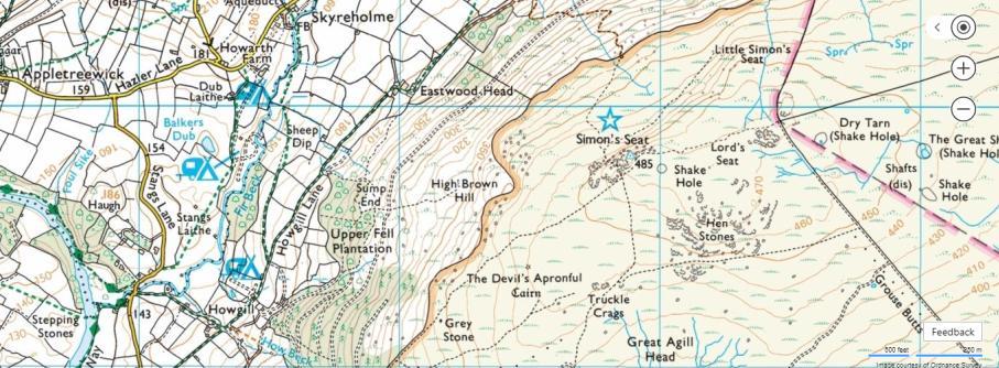
Little Simon s Seat. Little Simon s Seat. Unknown Stones. Climbs 32 Altitude 450m a.s.l. Faces North West
|
|
|
- Leonard Caldwell
- 5 years ago
- Views:
Transcription
 ranging in height from diminutive to highball.")

1 Climbs 32 Altitude 450m a.s.l. Faces North West Other condition info: A jumble of boulders that are composed of good, silvery grit, set high on Simon s Seat. Problems have been done over the years but nothing recorded until now. There are some very good boulder problems (and some that are really routes) ranging in height from diminutive to highball. Landings are generally ok except where noted in the script - a couple of pads are recommended. Though northfacing the problems are clean and dry quickly. Easily combined with a visit to Dale Head Rocks, Lord s Seat or Simon s Seat. Beware the odd man-eating hole amongst the heather. Paul Clarke Smiling Through the Apocalypse Parking and approach info: The best staring point is the parking at the foot of the Howgill to Simon s Seat path from where there are two alternatives. 1/ Go over Simon s Seat towards Lords Seat and drop down a little way before there, as the rocks come into view. 2/ Follow the valley track and then up the zig-zags to Dale Head Rocks (the ones over the stile/wall that gives access to CRoW land) then bash up through the heather to LSS - less distance and climbing but with some heather bashing. Either way takes around 40 minutes

2 The Wolfe Boulder


3 Dragon Pinnacle Wolfe May Bug Features Triangulation Whale Rambler s The area is a bit confusing at first. However, the picture above should locate the various blocks. The first boulder(s) described lies at the foot of that ground just above the flatter area that lies below the crag. Triangulation Boulder The lowest boulder has a nice slabby face with a flake on the right. 2/ Correlation 6a LH in mono-pocket, RH on sidepull. Step on and up... 3/ Triangulation 6b+ ** Step up to gain the obvious ramp then upwards. 4/ R 4 Flake and right arête. 1/ Static Stick 4 The left arête from standing


 pop up for the side-pull with RH and hole with LH.")
4 Features Boulder Up and to the left. Dragon Boulder For those with an imagination it is possible to see a dragon s head. 1/ Features 5+ * Starting in the hollow, rock up to gain side-pulls and better holds. Above and around these two boulders are a number of slabs and blocks with potential for problems but the next obviously good problems are up to the left. 1/ Dragon 6b ** From standing (no mat pile) pop up for the side-pull with RH and hole with LH. A throw gains the left arête. A harder start uses a pocket and poor hold to pull on 6c/7a? 2/ Draco 5 * The right arête. A SDS adds difficulty but feels contrived. Back over to the right is a pinnacle/boulder below the upper left-hand jumble.


 with a fine scoop facing the valley and a lovely leaning wall on its right side.")
5 Pinnacle of Achievement. 0/ Ours is a Great Wild Country 6b * The narrow wall on the uphill side. The crack is out. 1/ No Country for Old Men 6a+ ** Climb upwards eventually using the left arête. No crack. 1/ Swag Juice 5+ The short arête. Top out direct or more easily leftwards. 2/ Tea Snob 5 Climb out using good rails and jugs. Cockchafer's Slab 1a/ Lacking the Will 3 The same crack and easy ground above. The massive jumble of blocks above here has some potential but lines and landings seem difficult to isolate. Right Area Well across to the right is a giant block (Wolfe Block) with a fine scoop facing the valley and a lovely leaning wall on its right side. The next problems are on the blocks below it starting down near an obvious featured slab. 1/ Cockchafer's Slab 5 * The centre of the hanging slab using a sloping rail, side pulls and shallow pockets. 2/ Slab Flake 2+ * The right side using the flake. Tea Snob


6 Whale Block 2/ Ramble On 4 * Climb the wall without the arête. 1/ Whale of a Time 6b * SDS on the underlying block. Reach out for the eye and then the ear and up. The up goes on for a long way but is easy. Easier for the lanky. Rambler's Block Just below the Wolfe Block. 1/ Rambler's Arête 3+ Move up the arête avoiding the block on the left.
 *** Pull into the scoop and follow it to undercut features leading right. As good an easy line as you will find anywhere.")

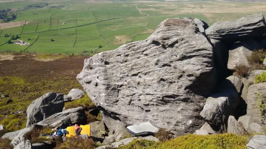
7 The Wolfe Block Most problems here feel high and the ones above the leaning wall are above a pile of blocks so a few (lots of?) mats are sensible. 1/ Mau-mauing the Flak Catchers 1+ (Moderate) *** Pull into the scoop and follow it to undercut features leading right. As good an easy line as you will find anywhere. 3a/ Take the Ride E5 6a (Font 6a+ with many mats and spotters) ** Follow Buy the Ticket and continue up the hanging arête with some trepidation avoiding the temptation to step off onto the jutting block. Only one short hard section but... 4/ Smiling Through the Apocalypse 6c+ *** A great problem. SDS at the crack and rail. Use this and a pocket to pull up and rightwards through the roof. Move up past a side-pull and another pocket to gain better holds and a fine finish. Easier from standing at the side-pull. Font 5 stepping of the block below the roof. 5/ The Right Stuff 5 ** Pockets and edges lead leftwards to a final move past a surprising pocket. 2/ The Bonfire of the Vanities 3 (Severe) ** Pull into the scoop and across to the horizontal. Join the dots, stepping right and back left to easier ground. 6/ Back to Blood 5+ ** SDS at holes. Pull up and left to a long reach and a finish. 7/ The Electric Kool Aid Acid Test 6b+/c ** SDS. Follow Smiling Through and traverse at ground level to gain and finish up Back to Blood. 3/ Buy the Ticket 5+ * SDS at the scoop and follow the arête to the break. Pull round left and escape.


8 Upper Blocks Just above the Wolfe Block is a roof/cave and a rippled wall to its right. May Bug Block Painted Blocks 1/ The Pockets 1 Step past pockets. 1/ The Painted Word 5+ SDS at the back of the cave with hands in a crack/thread. Climb out and over using surprising pockets and a belly flop. 2/ Upper Class 5 * Pull onto the wall using a good foot ramp. Span to the top and finish direct using the large bowl. 3/ May Bug Arête 6b+/c * SDS. The right arête using undercut pockets and a reach. From standing it is also good and 5+. The Step Over to the left 2/ A Man in Full 5 SDS. Rock up using ripples. 1/ The Step 3+ Pull on and step onto the step then step right to finish.

9 The Bowl Just above. 1/ Bowled Over 4 Pull into the large bowl. 2/ Annihilating 4+ SDS. The steep rough prow on the right.
Ilkley Buckstones. Ilkley Buckstones. Unknown Stones. Climbs 60 (Font 4 to7b). Altitude 390m asl. Faces All directions but mostly north.
. Altitude 390m asl. Faces All directions but mostly north.") Ilkley Buckstones Climbs 60 (Font 4 to7b). Altitude 390m asl. Faces All directions but mostly north. Other condition info: A group of boulders set high on the moors above Ilkley and the Aire Valley but
Ilkley Buckstones Climbs 60 (Font 4 to7b). Altitude 390m asl. Faces All directions but mostly north. Other condition info: A group of boulders set high on the moors above Ilkley and the Aire Valley but
Lund Stones. Lund Stones. Unknown Stones. Climbs - 40 Altitude 300m Faces South, South West Grid ref SE
 Climbs - 40 Altitude 300m Faces South, South West Grid ref SE 175713 Lund Stones Other condition info: An isolated edge with good rock, that, once cleaned, reveals fine and distinctive problems, across
High Crag (Stump Cross)
") High Crag (Stump Cross) Climbs - 25 Altitude 410m Faces North West Other condition info: Smart little edge and boulders with a useful collection of routes and problems in a convenient and fine location.
High Crag (Stump Cross) Climbs - 25 Altitude 410m Faces North West Other condition info: Smart little edge and boulders with a useful collection of routes and problems in a convenient and fine location.
Far Crag. Far Crag. Unknown Stones. Heather Top Wall. Other condition info: A fine little bouldering area in a pleasant location.
 Far Crag General Information Other condition info: A fine little bouldering area in a pleasant location. It OS Ref. SE152637 faces west and provides a number of very GPS good problems. Ideal for a few
1/ Clatterjack 7a * SDS under right side of the roof. Out to lip, left to the arête and up before stepping back right to finish
 14 Crow Crag The potential of Crow Crag has gradually come to light though lines still remain unexplored. Despite the woodland location the excellent rock dries pretty quickly and there are some strong
Long Crag. Long Crag. Unknown Stones. Other condition info: Excellent rock and a spectacular position make the boulders wellworth
 General Information OS Ref. GPS See Map See Map Long Crag Long Crag Other condition info: Excellent rock and a spectacular position make the boulders wellworth a visit. Altitude Aspect Conditions 400m
12 Plantation Crack Area.
 12 Plantation Crack Area. There has always been some good, though limited, bouldering at Plantation Crack. Over the years this has been developed and now adds up to a fairly substantial area spread along
Clint Quarry History Overview Approach
 Clint Quarry History The quarry has spiked the interest of various people over the years though recent additions by Steve Dunning, Dave Sutcliffe, Neil McCallum, Steven Phelps and Martin Whitton have renewed
Keeper Crack Area. Brimham Northern Edges. Unknown Stones. Climbs - 20 Altitude 270m Faces North, South, West and East
 Keeper Crack Area Climbs - 20 Altitude 270m Faces North, South, West and East Other condition info: Recently developed and redeveloped quality bouldering in the Keeper Crack area of Brimham North Edges.
Twin Towers. Unknown Stones. Twin Towers. Climbs - 26 Altitude 230m Faces North West
 Climbs - 26 Altitude 230m Faces North West Twin Towers Twin Towers A small crag, which makes up what it lacks in volume with the striking quality of its highball routes each constructed of the finest Slipstones
A popular area with Joker s Wall offering steep and fingery problems for the strong with a few other good bits here and there.
 Cubic Area Brimham A popular area with Joker s Wall offering steep and fingery problems for the strong with a few other good bits here and there. Parking and approach Easily accessible in 2 minutes from
Rowantree Tor. Rowantree Tor. Unknown Stones. Climbs - 50 Altitude 300m Faces South west
 Climbs - 50 Altitude 300m Faces South west Rowantree Tor Other condition info: Set in a fine position overlooking the upper section of Fosse Gill and at the end of Rowantree Crag Ridge, the area consist
Jenny Binks Boulders
 Climbs - 20 Altitude 370m Faces South Jenny Binks Boulders Jenny Binks Boulders Other condition info: A fine, quite high wall of perfect grit that is very Slipstones like and faces south in a fine position
Hong Kong Bouldering. Lai Chi Wai takes flight on Superhardness (V6). Photo: Stuart Millis HongKongClimbing.com. Page 42
. Photo: Stuart Millis HongKongClimbing.com. Page 42") Hong Kong Bouldering Lai Chi Wai takes flight on Superhardness (V6). Photo: Stuart Millis Page 42 L in Fa Shan General A superb set of boulders with problems of exceptional quality above generally flat
Hong Kong Bouldering Lai Chi Wai takes flight on Superhardness (V6). Photo: Stuart Millis Page 42 L in Fa Shan General A superb set of boulders with problems of exceptional quality above generally flat
Sigsworth Crags. Unknown Stones
 Crags Crags Amongst the most significant Wild Bouldering developments of late, this fine collection of boulders, set above the hamlet of Wath, enjoy a stunning outlook over Upper Nidderdale. The walk in
Hong Kong Bouldering. Steven Yip treading a Rocky Road (V6). Photo: Stuart Millis. HongKongClimbing.com. Page 36
. Photo: Stuart Millis. HongKongClimbing.com. Page 36") Hong Kong Bouldering Steven Yip treading a Rocky Road (V6). Photo: Stuart Millis Page 36 S hek Lung Kung General A fine set of boulders on very high friction rock. This area has the added bonus of a stunning
Hong Kong Bouldering Steven Yip treading a Rocky Road (V6). Photo: Stuart Millis Page 36 S hek Lung Kung General A fine set of boulders on very high friction rock. This area has the added bonus of a stunning
The Southern Pinnacles. Go uphill a short way along the path. Just after it levels out and in a depression down to the left is:
 Brimham South Area This 2-part circuit takes in the Southern Pinnacles and blocks that lay alongside the snaking Pinnacles Path. This starts at the Main Car Park and follows it as far as the obvious grassy
Eskdale Granite Bouldering Copyright Philip Wake
 Eskdale Granite Bouldering Copyright Philip Wake Directions (from the south) From the M6 motorway leave at junction 36 for Kendal/Lakes. Follow signs for Barrow. Before you reach Barrow, turn right to
Crimpy Roof Hare Heads
 Crimpy Roof Hare Heads General Information Grid Ref SE 213 651 Parking GPS 54.08003-1.676450 Altitude 272M Aspect All SW Conditions Quick drying, afternoon sun and all the wind Plod Time 5 Mins Landings
Topos curated by The Climbing Academy, Ring Road Boulders
 Ring Road Boulders Location and Approach There are various approaches to get to the bouldering. The one described here takes about 10 minutes. Park on Hartford drive, approached by turning right off the
Yeadon Crag. Parking and Approach: Boots or wellies are a must as the approach has a small, unavoidable boggy patch.
 Yeadon Crag Yeadon Crag is the southernmost end of the crag series which runs south from Sypeland and is unquestionably one of the most significant Wild Bouldering developments of recent years in Yorkshire.
CRANBERRY. Introduction
 Introduction Introduction The Cranberry Boulders are a group of 60 problems set in a beautiful mossy forest above the Cranberry Creek. The boulders are located approximately 36km south of Revelstoke on
Brimham - The Central Area
 Brimham - The Central Area A fine circuit with some of the most travelled problems at Brimham and some neglected goodies. A varied array of edge and block challenges. Walking up the main track towards
Burley Moor Crags THE BURLEY MOOR CRAGS. Coldstone Beck Crag SE Unknown Stones Page 1
 THE BURLEY MOOR CRAGS SE145451 Coldstone Beck Crag is the obvious quarried area at the top of the footpath leading up from the parking spot on the Moor Road between Burley Woodhead and Ilkley. There is
Hudeshope Pennines
 408 Pennines 409 Monk's Moor Boulders OS Landranger Sheet: 92 Map Reference: NZ962289 Aspect: West to North West Altitude: 560m Approach: 30 minutes Mod - Severe 0 HS - HVS 0 E1 - E3 0 E4 and above 0 Bouldering
Eastby. Eastby. Climbs 50+ Altitude 320m Faces South
 Eastby Climbs 50+ Altitude 0m Faces South Other condition info: Good all year venue. The crag is a big sprawling affair with many good areas. Generally the problems are quite high and some landings are
11 Bat Buttress. Do not access this crag by crossing the wall from the National Trust Estate.
 11 Bat Buttress Bat Buttress is a series of walls and block set amid a bigger edge that has some fine routes. The rock is generally very good and the south facing aspect means it gets plenty of sunshine.
Gate House Crag. Unknown Stones. Gate House Crag (A4 Feb 17)
") Gate House Crag This is an excellent and long overlooked moorland bouldering venue with good rock and flat landings. It is generally south facing, though with walls of varying aspect, and an easy 25 minute
Gate House Crag This is an excellent and long overlooked moorland bouldering venue with good rock and flat landings. It is generally south facing, though with walls of varying aspect, and an easy 25 minute
Routes Third Friend Lucky E2 5c 8m * The right edge. Problems Green Wing V4 * A varied low traverse from right to left.
 West Chevin Boulders Situation and Character A woodland situation, just below the Chevin summit. It is fair to say these boulders will never achieve classic status due to the prevailing greenery (but don
The Flu sits on a west facing hillside and doesn t get as much sun as the other areas. The stone tends to hold moisture much longer and becomes
 The Flu sits on a west facing hillside and doesn t get as much sun as the other areas. The stone tends to hold moisture much longer and becomes brittle when wet. So please refrain form climbing in the
Tan y Grisiau Boulders
 Tan y Grisiau Boulders Area: Blaenau Ffestiniog Aspect: South Rock type: Rhyolitic Tuff Approach: 10 15 minutes Altitude: 400m OS grid ref: 679 454 Hippocampus New Noise 8A/+ 8A/+ Flick of the Wrist 7C/+
Lad Stones Bouldering. By Greg Chapman
 Lad Stones Bouldering By Greg Chapman Introduction Approach & Overview Map Aspect Situated on the southern flanks of Wetherlam, east of Levers Water and the Coppermines Valley, the mighty Lad Stones sit
The First Wall is a good place to get warmed up with several short pleasant wall climbs and one tricky sitter.
 Gate House Crag This is an excellent and long overlooked moorland bouldering venue with good rock and flat landings. It is generally south facing, though with walls of varying aspect, and an easy 25 minute
4 - Flight of the Osprey - V1+ * Climb the nice arête on the far right from a sit start on an awesome side pull feature. Fun!
 Cave The first boulder(s) you encounter on the trail down, 2 minutes from the car. Home to some of the best boulder problems in Nelson, a little here for everyone. The Axe traverse should not be missed!
Doolin - Bouldering DOOLIN B OULDERING. Al Sarhan on Fireworks 7b. Al Sarhan on Fireworks 7b
 Doolin - Bouldering replace front.pdf 14/09/2007 09:29:23 Al Sarhan on Fireworks 7b Doolin - Bouldering Al Sarhan on Fireworks 7b This is sample pdf download from the upcoming Burren and Aran Island Rock
Self-Guided Walk Langdale Pikes. Start & Finish: NT car park (free to members) at Sticklebarn - on the right just beyond the New Dungeon Ghyll hotel.
 at Sticklebarn - on the right just beyond the New Dungeon Ghyll hotel.") Self-Guided Walk Langdale Pikes Key Information These mountains form a collection of spires and cliffs on the north side of Langdale. This walk visits four of the main tops Pavey Ark, Harrison Stickle,
Self-Guided Walk Langdale Pikes Key Information These mountains form a collection of spires and cliffs on the north side of Langdale. This walk visits four of the main tops Pavey Ark, Harrison Stickle,
Bouldering Guide. The Shrine. February 06, 2010 Jason Allemann Kristal Dubois.
 The Shrine Bouldering Guide February 06, 2010 Jason Allemann Kristal Dubois www.topout.org The Shrine contains the largest concentration of developed boulders in the Ottawa/ Gatineau region. Most of the
Bear Mountain Bouldering A guide by Trent Hoover
 Bear Mountain Bouldering A guide by Trent Hoover The windmills of the Bear Mountain Wind Farm are a distinctive feature of the Bear Mountain climbing area 1 Bear Mountain Bouldering (August 2012) Bear
You can also park on the side of the highway for a shorter approach; if you don t mind having your car towed. I was ticketed once and towed once.
 ARBUTUS GROVE Good problems, good views and closer than Squamish make this an attractive climbing spot for a few hours of fun. The freeway makes it a little noisy. Low vegetation (due to power line clearing)
Lost Causes. A Climbing Guide to the Mesilla Valley. Installment 2.4. Dona Ana Mountains Pizza Boulders. By: Charles Cundiff
 Lost Causes A Climbing Guide to the Mesilla Valley Installment 2.4 Dona Ana Mountains Pizza Boulders By: Charles Cundiff Pizza Boulders Legend has it that back in the day (somewhere between 1960 and 1986)
THE BULLSTONES. Grid. Ref. SD
 THE BULLSTONES. Grid. Ref. SD 675 577. A collection of boulders and small edges on the south slopes of White Hill above Croasdale in Bowland north west of Slaidburn. They lie in a high [450m] remote moorland
CAPE ST. FRANCIS SEASIDE BOULDERING IN THE INDEPENDENT STATE OF THE EASTERN CAPE. 1st Edition NIEL MOSTERT
 CAPE ST. FRANCIS SEASIDE BOULDERING IN THE INDEPENDENT STATE OF THE EASTERN CAPE 1st Edition NIEL MOSTERT On the Cover: Martin Renz on Spongebob (7A), The Cove Cape St. Francis Seaside Bouldering in the
Ash Head Crag. Ash Head Crag (A4) Unknown Stones
 Unknown Stones") Ash Head Crag Ash Head Crag (A4) Climbs - 140 Altitude 370m Faces NW to SW Condition info: A fine, remote crag high on Masham Moor with some good routes up to 10m and some excellent bouldering. Don't be
Ash Head Crag Ash Head Crag (A4) Climbs - 140 Altitude 370m Faces NW to SW Condition info: A fine, remote crag high on Masham Moor with some good routes up to 10m and some excellent bouldering. Don't be
Route #2) Mt. Massive - Southwest Slopes
 Mt. Massive - Southwest Slopes") Route #2) Mt. Massive - Southwest Slopes Difficulty: Class 2 Ski: Advanced, D6 / R2 / III Exposure: Summit Elevation: Trailhead Elevation: Elevation Gain: Round-trip Length: Trailhead: County Sheriff:
Route #2) Mt. Massive - Southwest Slopes Difficulty: Class 2 Ski: Advanced, D6 / R2 / III Exposure: Summit Elevation: Trailhead Elevation: Elevation Gain: Round-trip Length: Trailhead: County Sheriff:
Hiking Las Vegas.com
 Hike: Mt. Wilson via First Creek Canyon route Trailhead: First Creek marked Distance: 10 miles up and back Elevation gain: 3,400 feet Elevation of Peak: 7,070 feet Time: 7 to 9 hours (up and back) Difficulty:
Carrock Fell Bouldering. By Greg Chapman
 Carrock Fell Bouldering By Greg Chapman N Introduction: Aspect & Conditions Quietly nestling on the Eastern flank of a remote North Lakes fell side lies a truly magical boulderering paradise. Countless
The Nest Bouldering Guide By Marc Eveleigh Updated March 24 th, 2016
 The Nest Bouldering Guide By Marc Eveleigh Updated March 24 th, 2016 Introduction The Nest is a small bouldering area set in a neat section of canyon with a rushing stream. Originally called Mophead a
ID: 283 Distance: 6.2 miles Height gain: 500 Metres Map: Explore OL 19 Contributor David and Chris Stewart
 Walkingworld Wild Boar Fell ID: 283 Distance: 6.2 miles Height gain: 500 Metres Map: Explore OL 19 Contributor David and Chris Stewart Features Birds, Great Views, Hills or Fells Description: Wild Boar
House Area: Frank Slide Bouldering
 House Area: Frank Slide Bouldering Trent Hoover and Kyle Marco The House Boulder Area, located at the northwest edge of Frank Slide, is one of the most easily accessible sectors at the Slide. From a large
Short Wall Hog's Back Caves 1. East Land 1332 and 2. King of Swing 1. Unnamed YankOnThis.com 2. Unnamed Lost and Alone Buttress 3. K7 4.
 12 Short Wall Short wall between black slabs and the buttress. East Land 1332 SDS - Start left of big bowl shaped hueco on large low pocket, traverse right into hueco, and then straight up. 2. King of
The Bridestone Rocks from Lydgate
 Print this page Back to results The Bridestone Rocks from Lydgate Ancient tracks and gritstone outcrops, with terrific views of the steepsided Cliviger Valley. Distance 5 miles (8km) Minimum time 2hrs
EAGLE PASS. Introduction
 Introduction Introduction The Eagle Pass Boulders are located west of Revelstoke, BC above the Trans-Canada Highway on the south flank of the aptly named Boulder Mountain. Development started in the summer
Lordenshaw. What are cup & ring marks?
 Lordenshaw Lordenshaw hill has one of the largest clusters of ancient cup and ring marked stones in the UK. We ve chosen four interesting spots we d like to share with you. What are cup & ring marks? The
Hiking Las Vegas.com
 Hike: Juniper Peak up and back Trailhead: Oak Creek Canyon marked Distance: 5.5 miles round trip Elevation gain: 2,200 feet Elevation peak: 6,109 feet Time: 4 to 5 hours - Up and back Difficulty: 3 Danger
COSTA BLANCA MOUNTAIN WALKERS - WALK DESCRIPTION. Visit for more walks descriptions in Spain
 COSTA BLANCA MOUNTAIN WALKERS - WALK DESCRIPTION Visit www.walksinspain.org for more walks descriptions in Spain Walk description originally prepared by:- Ralph Phipps Last Updated 25th Sep 2015 Title
Griffith Park Trail Run Trail Guide Click for
 The Griffith Park Trail Run by Hike- LosAngeles.com Griffith Park Trail Run Trail Guide Click for downloadable cell phone guide and map from EveryTrail. DISTANCE: 4.55 Miles ELEVATION: 1280' ELEVATION
Battleship Beach. About 500m. Portland Heights Hotel. The George. Blacknor Fort p.56. Easton. Weston. Blacknor Beach p.60 GPS
 78 79 Blacknor Fort p.56 Blacknor Beach p.60 p.80 The George Reap Ln Weston Southwell Weston Rd Wide St Portland Heights Hotel Easton GPS 50.534080-2.449243 Wes ton St About 500m scan for map is typified
LAS VARAS RANCH CA COASTAL TRAIL PROPOSED ALIGNMENT
 LAS VARAS RANCH CA COASTAL TRAIL PROPOSED ALIGNMENT Santa Barbara Trails Council * Prepared by Ray Ford February 1,2012 The following notes accompany the Santa Barbara Trails Council map for the Las Varas
Mt. Elbert East Ridge
 Mt. Elbert East Ridge Difficulty: Class 1 Exposure: None Summit Elev.: 14,440 feet Trailhead Elev.: 10,400 feet Elevation Gain: 4,100 feet Roundtrip Length: 8.5 miles Trailhead: South Elbert (near Twin
Arches of the. Sandflats Area. By Virginia Allen
 Arches of the Sandflats Area By Virginia Allen TABLE OF CONTENTS Introduction Dedication Road Log Arches 1. Perforated View Arch 2. Fee Booth Arch 3. Windsong Arch 4. Weird Arch 5. Resting Arch 6. Bike
The Story of Stickeen
 r4 WT/Math/Rdg Rel '03 4/3/03 11:55 AM Page 65 Read this selection. Then answer the questions that follow it. The Story of Stickeen John Muir (1838 1914) was a well-known author and explorer who helped
Baggy Point, Croyde, North Devon
 Baggy Point, Croyde, North Devon A walk using the South West Coast Path that is likely to be suitable for people with impaired mobility or with a pushchair, wheelchair, or mobility scooter. The Coast Path
Cratcliffe Robin Hood s Stride Eagle Tor Rowtor Rocks Stanton Moor Harthill and more 5: The Cratcliffe Area
 No times observed, nor charitable lawes, The poor receive their answer from the dawes, Who, in their crawling language, call it plaine, Mock-beggar Manour, for they come in vaine. Taylor: Works from A
Borrowdale and Derwent Water Access Statements
 Borrowdale and Derwent Water Access Statements Currently the following Access Statements are available for Borrowdale and Derwent Water, click on the links below to go direct to the statement for that
HARDMOORS 55 RACE ROUTE 2018 HELMSLEY - GUISBOROUGH
 HARDMOORS 55 RACE ROUTE 2018 HELMSLEY - GUISBOROUGH HELMSLEY - CHECKPOINT 1 (WHITE HORSE) 1. Leave RACE START, continue ahead on road (Baxtons Sprunt) At crossroads turn right down Canons Garth eventualy
Gap of Dunloe. Bouldering Guide. -Main Face Area -Head of Gap Area -Black Valley Area. Eoin Kennedy 07/04/09
 Gap of Dunloe Bouldering Guide -Main Face Area -Head of Gap Area -Black Valley Area Eoin Kennedy 07/04/09 eoineoineoin@gmail.com 1 2 Introduction This is a basic guide for the some of the bouldering that
WaihekeIsland STU KURTH ON THE TIGER V2 BYSTERLINGANDSTEADASSOCIATES
 WaihekeIsland BOULDERGuide STU KURTH ON THE TIGER V2 BYSTERLINGANDSTEADASSOCIATES PROBLEMSBYAREA FIRSTROUNDAREA First Round Boulder 1. Sleepy Girl V0 PAGE 08 2. First Round V0 PAGE 08 Chunky Boulder 3.
2017/08/27. Derek Marshall 1
 0/0/ Derek Marshall General St Francis is a seaside fun-in-the-sun holiday resort town. Bouldering is part of the fun, keep it fun! Directions & Map Get smart, use Google to get there! http://www.easterncaperockclimbing.co.za/location/cape-st-francis
One Scary Night. Grace A. Fynn
 One Scary Night By Grace A. Fynn EXT.STREET-NIGHT It rains heavily. People run, some with umbrellas, others with their hands over their heads. Two men aged 30 and 40 respectively each carrying a suitcase
Tenerife Sur: Short Walks Under 10 km. Casa del Ancon Circular (Arona) Route Summary. Route Overview. Description
 Route Summary. Route Overview. Description") Tenerife Sur: Short Walks Under 10 km Casa del Ancon Circular (Arona) Route Summary This short circular walk from Arona is very scenic, with reminders of rural life in previous times. Route Overview Duration:
Tenerife Sur: Short Walks Under 10 km Casa del Ancon Circular (Arona) Route Summary This short circular walk from Arona is very scenic, with reminders of rural life in previous times. Route Overview Duration:
Canopy Tour & Aerial Adventure Course Selection Guide
 Canopy Tour & Aerial Adventure Course Selection Guide The Adventure Network offers a wide range of Canopy Tour and Aerial Adventure Course options for any size program. Whether your goal is to create a
ENGLISHMAN. Introduction
 Introduction The Englishman Boulders are a collection of roughly 150 problems situated on the banks of Englishman Creek. The boulders are located approximately 20km west of Revelstoke on the 3 Valley/
Kangaroo Point Bouldering Guide
 Kangaroo Point Bouldering Guide Introduction KP is the home of Queensland finest contrived boulder problems. So if you don t like contrived problems, please stop reading this page. The grades we have given
PERUVIAN ANDES ADVENTURES. EXPEDITION Climbing Alpamayo & Huascaran. PEAKS: Maparaju 5350m Alpamayo 5947m Huascaran Sur 6768m
 PERUVIAN ANDES ADVENTURES EXPEDITION Climbing Alpamayo & Huascaran PEAKS: Maparaju 5350m Alpamayo 5947m Huascaran Sur 6768m 23 days Huaraz to Huaraz Grade: Technical, physically demanding This is a comprehensive
September Newsletter. Search for Ayios Georgios. Sharing experiences as we journey together
 Sharing experiences as we journey together Search for Ayios Georgios This is my third newsletter this year and comes 6 months after I published the last one. I decided to change the format for this edition
Wicklow Mountains Path Survey
 Wicklow Mountains Path Survey Glenmacnass Tonelagee Start to Finish: O 114 030 to O 085 016 Altitude (lowest highest): 370m 817m Weather: Sunny day, hot Access: Military Road, Glenmacnass Surveyed by:
THE SMUGGLERS TERRACE. NORTH YORKSHIRE MOORS October 2014 Mini-Guide
 THE SMUGGLERS TERRACE NORTH YORKSHIRE MOORS October 2014 Mini-Guide Directions From the parking at Station Square, Ravenscar, follow the Cleveland Way north-west towards the hotel. When passing a second
Guide Book Excerpts. Wham Ridge 2006
 Guide Book Excerpts Wham Ridge 2006 Approach: Molus Lake / Elk Park / Vestal Creek Roach and Roach Description Take the Durango & Silverton Narrow Gauge train from either Durango or Silverton and get off
TREK THE ROCKIES ABOUT THE CHALLENGE TREK THE ROCKIES FOR HIGHLAND HOSPICE CANADA TREK DEMANDING
 TREK THE ROCKIES CANADA TREK DEMANDING ABOUT THE CHALLENGE The Canadian Rockies are justifiably world-famous for their magnificent scenery: the combination of impressive, jagged mountains, bright turquoise
Kirigalpoththa Nature Trail Horton Plains National Park
 Kirigalpoththa Nature Trail Horton Plains National Park Trail Difficulty: Easy Moderate Strenuous Tough Trail Head: Horton Plains Visitor Centre Nearest Town: Pattipola Nearest City: Nanu-Oya Access to
Orienteering. The fundamental outdoors skill!
 The fundamental outdoors skill! Orienteering Nothing will make you feel more confident in the out of doors like knowing how to find your way in the woods. Orienteering Prepared by: Jeffrey Lybarger Assistant
Whittling Chip Class Pow Wow 2010
 Safety First-rules for adults teaching 1. Make sure to have a first aid kit at every lesson. 2. Have water and towels available to wash hands; flush eyes! 3. Treat the wooden knife like a real knife (-if
ARDESTIE EARTH HOUSE HISTORIC ENVIRONMENT SCOTLAND STATEMENT OF SIGNIFICANCE. Property in Care no: 24
 Property in Care no: 24 Designations: Scheduled Monument (SM90021) Taken into State care: 1953 (Guardianship) Last reviewed: 2004 HISTORIC ENVIRONMENT SCOTLAND STATEMENT OF SIGNIFICANCE ARDESTIE EARTH
Route Combo) Mt. Bierstadt - Bierstadt, Sawtooth, Evans
 Mt. Bierstadt - Bierstadt, Sawtooth, Evans") Climbing 14ers can be very dangerous, please read the Mountaineering Safety Page and make sure you have a map+compass and can use them effectively, without the help of electronic devices. Route Combo)
Climbing 14ers can be very dangerous, please read the Mountaineering Safety Page and make sure you have a map+compass and can use them effectively, without the help of electronic devices. Route Combo)
Grizzly Peak A - East Ridge July 15, 2012
 Grizzly Peak A - East Ridge July 15, 2012 Difficulty: Difficult Class 2/Class 3 Upper Elevation: 13,995 feet Trailhead Elevation: 11,360 feet Elevation Gain: 3,000 feet Round-trip Length: 6.0 miles Trailhead:
Unit 1: Physical Environment Glaciated Landscapes
 Unit 1: Physical Environment Glaciated Landscapes Corries Corries are bowl-shaped hollows high up in the mountains. They are formed in the following way: Snow collects in a hollow on a mountainside (usually
Darwin s gigantic blunder
 Trail Darwin s gigantic blunder Explore how ice shaped the landscape and why Charles Darwin made a nice mess of Glen Roy Time: 1hr 10 mins Distance: 2 miles Landscape: rural At Glen Roy a curious feature
REPORT. MANASLU EXPEDITION (8163 m) Track NE (traditional)
 Track NE (traditional)") REPORT MANASLU EXPEDITION (8163 m) Track NE (traditional) Contents Expedition passport 2 Description of the route 3 Description of the expedition 4-5 Scheme of the route 6 Map of the route 7 Map of the
REPORT MANASLU EXPEDITION (8163 m) Track NE (traditional) Contents Expedition passport 2 Description of the route 3 Description of the expedition 4-5 Scheme of the route 6 Map of the route 7 Map of the
Formation of a Corrie
 Formation of a Corrie A corrie looks rather like a armchair has been cut out of the rock face When a hill has been heavily eroded with 3 or 4 corries the jagged hill that is left is known as a pyramidal
COLONEL FOSTER, FULL TRAVERSE
 Thank you for choosing Island Alpine Guides for your Colonel Foster Traverse. This package contains useful information to help you prepare for the trip, including a complete equipment list. We will be
Juan de Fuca Trail Hiking/Backpacking Guide
 Juan de Fuca Trail Hiking/Backpacking Guide By Candice Camera Brief Background of the JDF Trail The Juan de Fuca Trail is a located in Juan de Fuca Provincial Park on Vancouver Island. The 47KM trail goes
TUPPER DESIGNATED ACCESS ROUTE
 TUPPER DESIGNATED ACCESS ROUTE 1 FOR ACCESS/EGRESS TO CONNAUGHT, LOOKOUT, STONE ARCH, PORTAL PATHS AND TUPPER TRAVERSE EGRESS Length: 2.6km Vertical Gain: +162m / -83m (Values are for access. For egress,
50miler.com Outing Resource Center on Facebook
 Snow Camping Shelters and Camps http://50miler.com Camp Lay Out Upon reaching a reasonable camp site, leaders should find spots for the kitchen, latrine, cleanup sump, and snow caves. Paths are then established
Tiger Mountain State Forest:
 98 60 hikes within 60 miles: SEATTLE 20 Tiger Mountain State Forest: West Tiger Mountain Three Loop i KEY AT-A-GLANCE INFORMATION Length: 5.1 miles round-trip Configuration: Loop Difficulty: Moderate difficult
Red Tarn, Lake District They are all features of glacial erosion
 Ribbon Lake Lake Windermere, Lake District Arete Striding Edge, Lake District 1 2 3 Pyramidal Peak Corrie & Tarn 4 Matterhorn, Switzerland Red Tarn, Lake District They are all features of glacial erosion
The Stell A Bouldering Guide Part One
 Northumbrian Mountaineering Club Supplement Alec Burns On The Figurehead Bob Smith A series of downloadable PDF guides to new bouldering venues, problems, highballs and routes in Northumberland. Including:
Typical avalanche problems
 Typical avalanche problems The European Avalanche Warning Services (EAWS) describes five typical avalanche problems or situations as they occur in avalanche terrain. The Utah Avalanche Center (UAC) has
McKenzie Pond, New York This guide book originally came into existance merely as a means to make discussing the bouldering here easier. It was not int
 M c K e n z i e b o u l d e r i n g P o n d g u i d e a l s o k i P p Y g R o o V e R k i D d o s u a V e McKenzie Pond, New York This guide book originally came into existance merely as a means to make
Approximate distance: 5.5 miles For this walk we ve included OS grid references should you wish to use them. Start. End
 Approximate distance: 5.5 miles For this walk we ve included OS grid references should you wish to use them. Start End 2 1 5 4 6 3 N W E 7 S Reproduced by permission of Ordnance Survey on behalf of HMSO.
Tenerife Sur: Short Walks Under 10 km. Cabo Blanco - La Camella Circular (Arona) Route Summary. Route Overview. Description
 Route Summary. Route Overview. Description") Tenerife Sur: Short Walks Under 10 km Cabo Blanco - La Camella Circular (Arona) Route Summary An interesting town and country walk, with some marvellous views, in a well-populated residential area close
Tenerife Sur: Short Walks Under 10 km Cabo Blanco - La Camella Circular (Arona) Route Summary An interesting town and country walk, with some marvellous views, in a well-populated residential area close