MORAINE COMPLEXES AND CERTAIN QUESTIONS CONCERNING PALEOECOLOGY OF THE TRESKELEN REGION IN THE HORN SUND FIORD (W. SPITSBERGEN).
|
|
|
- Stephen Austin
- 5 years ago
- Views:
Transcription
.")
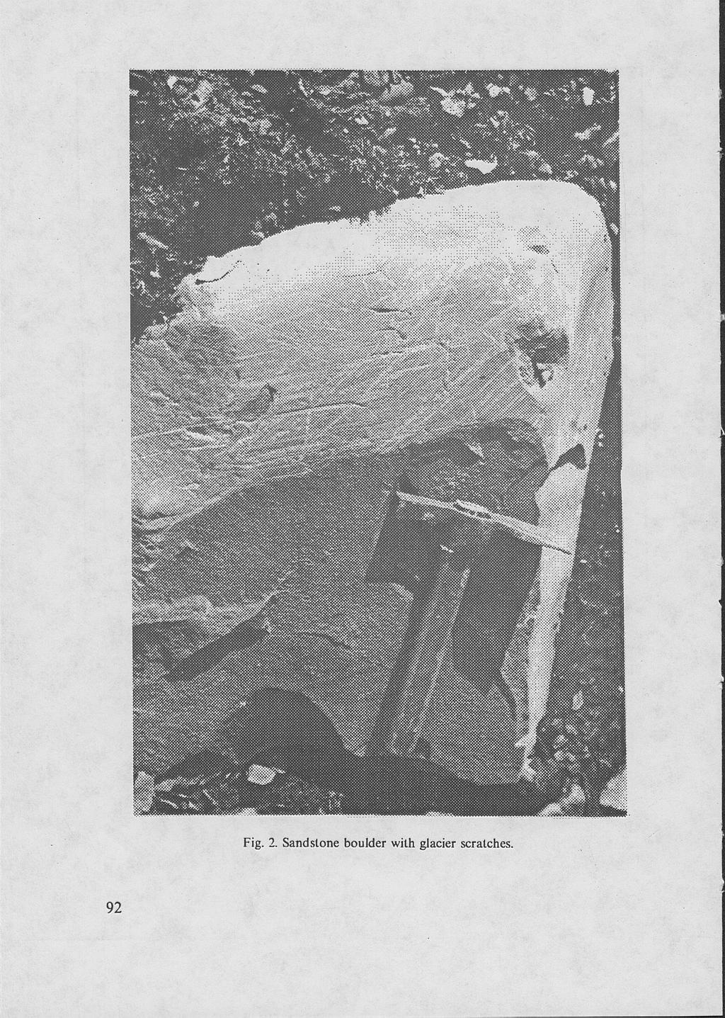
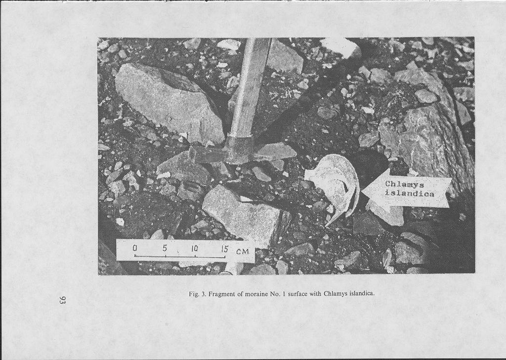
1 G. A. Tarasov, S. G. Denisenko, G. G. Matishov, I. A. Pogodina Murmansk Marine Biological Institute of the Russian Academy of Sciences Wyprawy Geograficzne na Spitsbergen UMCS, Lublin 1992 MORAINE COMPLEXES AND CERTAIN QUESTIONS CONCERNING PALEOECOLOGY OF THE TRESKELEN REGION IN THE HORN SUND FIORD (W. SPITSBERGEN). Material for this investigation was collected in June-July 1991 during the 49th voyage of the R/V Pomor" to the final part of the Hornsund Fiord. Moraine complexes of Treskelen Peninsula and moraine ridges above they sea level in the vicinity of the Storbeen Glacier (Fig. 1) were investigated. All those parallel ridges form a chain of moraine massifs left by a glacier in the last hundred years. The surface of the moraines is characterized by undulated-hilly relief with amplitudes of height changes 2-3 m. The altitude decreases from west to east beginning from 40 m (moraine No. 1) to 15 m (the last moraine). They are covered with one type of material, dark-gray in colour, which is built of various clay-sand particles with a great amount of stone material. A deep part of the moraines contains also sharp parts of rocks of different sizes and various degrees of rounding. Traces of ice scratches can be found on large rock boulders (Fig. 2). Afine grained part of the moraine massif looks like a concrete mass. Sometimes, especially on steep slopes, due to its consistency, the mass flows down. It is deposited on the submarine slope of Treskelen, down to the depth of 60 m. Numerous foraminifers and a grea amount of bivalvians (Fig. 3) can be found in moraines. Apart from them, there are also very well preserved red calcareous algae of Lithothamnion genus. Groups of bryozoans Celleporina ventricosa, Cellepora sp., Porella princeps, Porella minuta, Microporella ciliata have been found on shells of Chlamys islandica (moraine No. 1). Paleofaunal complex of bivalve molluscs in sediment of the moraine No. 1 is represented by the following forms (beginning from the most important ones): Chlamys islandica, Hiatella arctica, Mya truncata, Elliptica elliptica, Tridonta borealis. Chlamys islandica, Mya truncata, Tridonta borealis v. placenta, Elliptica elliptica can be found in sediments of the moraine No. 2. Chlamys islandica, Elliptica elliptica, Mya truncata, Astarte crenata in moraine No. 3 and Hiatella arctica in the moraine No. 4. Radiocarbon dating of shells of Chlamys islandica from the moraine No. 1 given the age 8380 ±80 years (GIN 7083), and from the moraine No ± 200 (GIN 7084). The samples taken from the moraine No. 1 in location 5, 20, 40 m a.s.l. contained a large number of benthos foraminifers (Fig. 4). Plankton forms also appeared there. The following foraminifers have 89

2 also been found in the complex: Elpidium clavatum, Cassidulina reniforme, Astrononion gallowayi, Cibicides lobatulus. Their shelters were very well preserved. Such forms are typical for arctic shelf complexes. Shallow water types Protelphidium orbiculare, Elphidium bartletti, and another type Nónion labradoricum (up to 5.3%) have also been found in the samples collected in localities 5 to 20 m a.s.l. In the layer No. 2 in the submarine part of the Treskelen slope, at the depth 60 m the amount of foraminifers decreases (Fig. 5). The dominating species are Cibicides lobatulus, Cassidulina reniforme, Elphidium clavatum, Astrononion gallowayi. There are also sand forms Spiroplectamina biformis there. A slightly different picture can be observed in the lower layer of bottom sediments No. 3, collected 200 m from the front of the Hans Glacier at the depth 50 m (Fig. 5). Here, most of foraminifers are juvenile forms, which are difficult to be recognized. The most popular are Cassidulina reniforme. The number of shelters varies from 180 to 200 m pieces, the highest amount is at the level 55 cm. A cross section Bel-1 (Bellsund Fiord) is quite similar, but the most common is Elphidium clavatum and a bit less common Cassidulina reniforme. Such taxonomic similarity of paleofaunal complex of bivalve molluscs in all the moraines proves their identical biocoenic occurrence. Formation of foraminifers complexes which can be found in moraines took place in normal marine conditions. The glaciers Stor and HoriTentered thefiord not more thenfive times in the last ten thousands years. The glaciers deposited sediments on the bottom during their movements, moved and also deposited material from upper layers on rock blocks situated across the fiord. Obviously, each time during movements the glaciers formed moraines. The oldest one is moraine No. 1 which means that previously the glaciers were much larger. 90

3 Fig. 1. Location of moraines and places where samples were collected in the Hornsund Fiord. 91
4
5

6 СП tva С ^ О О m above sea level ««С о» ГО со о Q.u,Lnq.uelocuUna sp. PatelUna corrugata CLblcld.es lobatulus Buccella friglda NorxLonella auricula f/onionelllna labradorica Astrononion pallo way С &lph.ictiella arctica Sbphidium subarcticum Slphidlum bartletti Glphidlum orbiculare- &lph.icuum clairatum CassCdulina reniforme Islanaiella helenae Islandiella norerossi Trifarina fluens Sta.inforth.La loeblichl BolLvina. pseudopunctata PobymorphLnldae spp. bentalina Lttai Lagena sp. Lagena apiopleura Lagena strtato punctata OolLna costatcc Oolina melo Fissurina marginata FCssurina serrata Fissurina sp. Number of ben.th.lc specimens per 100 g of dry sediment -с о N> го "О r^ -с Number of species 4. Distribution of foraminifers in sediments of moraine No. 1.

7 I F itl-lllsm Но- 3 Г Mm) Иг-ИЮ ml Core number (water depth) / - A Weight percentage of ^ ^ V. seltre fraction > 0.05 mm, V» a «H ^ -t о о о О о о «Л ««И S 3 в М 0 0^ е»- Sample. depth In em ООО Adtreotryma Heephax scottll т п в TrochammlnoUa. glomtrata Spiroptoctammlna biformls sp. - qutneuclocullna ebpcrella advena т Pateulna cormoata stauteri КозаМпа ClbiciŁes lobatulus Ruecetla зрр. ttonlonellina trlglda iabradorica Astrononion Mel on is ta.rlita.nuj eiphietium ga.lleura.yi tlphidium subarcticum Ca.33iCLuJ.ina cla.tratu.rn reniformt Stain lslandiella helenae - Bolivina fort/ii sp. a lotblic/ti Labena Polirm orph graciluma in iclat spp. Indefinite FiSsurina зр. и v. мм «к Neogloboquadrina /feoglotoquadrma pachyderma pachyderma sen. dex. >гг \ Number of benthic specimens per 100 g of dry sediment ^ о number of species Л Ла «М о л a faunal dominance, */«Fig. 5. Distribution of foraminifers in bottom sediments in Hornsund and BelJsund Fiords. 95
S. G. Detlisenko, G. A. Tarasov. Wyprawy Geograficzno na Spitsbergen. of Russian Academy of Sciences
 S. G. Detlisenko, G. A. Tarasov Murmansk Marine Biological Institute Wyprawy Geograficzno na Spitsbergen UMCS, Lublin 1992 of Russian Academy of Sciences FOSSIL COMPLEXES OF BIVALVE MOLLUSCS WITH PREVALENCE
1 Glacial Erosion and
 www.ck12.org Chapter 1. Glacial Erosion and Deposition CHAPTER 1 Glacial Erosion and Deposition Lesson Objectives Discuss the different erosional features formed by alpine glaciers. Describe the processes
Recrystallization of snow to form LARGE. called FIRN: like packed snowballs. the weight of overlying firn and snow.
 Chapter 11 Glaciers BFRB P. 103-104, 104, 108, 117-120120 Process of Glacier Formation Snow does NOT melt in summer Recrystallization of snow to form LARGE crystals of ice (rough and granular) called
Table DR 1. Paleomagnetic sample positions, polarities, and notes
 Data Repository Item ### Dorsey et al. Data Repository, page 1 Table DR 1. Paleomagnetic sample positions, polarities, and notes Paleomag samples collected January, 2004. Thicknesses compiled and revised
Great Science Adventures
 Great Science Adventures Lesson 18 How do glaciers affect the land? Lithosphere Concepts: There are two kinds of glaciers: valley glaciers which form in high mountain valleys, and continental glaciers
A trip to Steindalen. - geology and landscape on the way to the glacier. Geoffrey D. Corner
 A TRIP TO STEINDALEN Excursion guide Please take this with you on your trip, but don t leave it behind as litter. A trip to Steindalen - geology and landscape on the way to the glacier A part of Geologiskolen,
1.4 Understand how moving ice acts as an agent of erosion and deposition. (Chap. 2)
") 1.4 Understand how moving ice acts as an agent of erosion and deposition. (Chap. 2) There are two types of glaciation. Alpine Glaciation Continental Glaciation Distinguish between the terms alpine glaciation
1.4 Understand how moving ice acts as an agent of erosion and deposition. (Chap. 2) There are two types of glaciation. Alpine Glaciation Continental Glaciation Distinguish between the terms alpine glaciation
The Physical Geography of Long Island
 The Physical Geography of Long Island A Bit About Long Island Length 118 miles Brooklyn to Montauk Geo202 Spring 2012 Width 23 miles at it s widest Area 1,400 square miles Formation of Long Island River
GLACIER STUDIES OF THE McCALL GLACIER, ALASKA
 GLACIER STUDIES OF THE McCALL GLACIER, ALASKA T John E. Sater* HE McCall Glacier is a long thin body of ice shaped roughly like a crescent. Its overall length is approximately 8 km. and its average width
Glaciers Earth 9th Edition Chapter 18 Mass wasting: summary in haiku form Glaciers Glaciers Glaciers Glaciers Formation of glacial ice
 1 2 3 4 5 6 7 8 9 10 11 12 13 14 15 Earth 9 th Edition Chapter 18 Mass wasting: summary in haiku form Ten thousand years thence big glaciers began to melt - called "global warming." are parts of two basic
Glaciers and Glaciation Earth - Chapter 18 Stan Hatfield Southwestern Illinois College
 Glaciers and Glaciation Earth - Chapter 18 Stan Hatfield Southwestern Illinois College Glaciers Glaciers are parts of two basic cycles: 1. Hydrologic cycle 2. Rock cycle A glacier is a thick mass of ice
Alpine Glacial Features along the Chimney Pond Trail, Baxter State Park, Maine
 Maine Geologic Facts and Localities September, 2009 Alpine Glacial Features along the Chimney Pond Trail, Baxter State Park, Maine 45 54 57.98 N, 68 54 41.48 W Text by Robert A. Johnston, Department of
Alaskan landscape evolution and glacier change in response to changing climate
 Alaskan landscape evolution and glacier change in response to changing climate Following the publication of two pictures comparing the length of the Muir Glacier in Alaska, USA in the June 2005 issue of
READING QUESTIONS: Glaciers GEOL /WI 60 pts. a. Alpine Ice from larger ice masses flowing through a valley to the ocean
 READING QUESTIONS: Glaciers GEOL 131 18/WI 60 pts NAME DUE: Tuesday, March 13 Glaciers: A Part of Two Basic Cycles (p. 192-195) 1. Match each type of glacier to its description: (2 pts) a. Alpine Ice from
Region 1 Piney Woods
 Region 1 Piney Woods Piney Woods 1. This ecoregion is found in East Texas. 2. Climate: average annual rainfall of 36 to 50 inches is fairly uniformly distributed throughout the year, and humidity and temperatures
GLACIATION. The Last Ice Age (see Chapter 12) and. Pleistocene Ice Cap. Glacial Dynamics 10/2/2012. Laurentide Ice Sheet over NYS
 and. Pleistocene Ice Cap. Glacial Dynamics 10/2/2012. Laurentide Ice Sheet over NYS") GLACIATION and New York State Prof. Anthony Grande The Last Ice Age (see Chapter 1) The Pleistocene Epoch began 1.6 mya. During this time, climates grew colder. There were numerous ice ages starting 100,000000
GLACIATION and New York State Prof. Anthony Grande The Last Ice Age (see Chapter 1) The Pleistocene Epoch began 1.6 mya. During this time, climates grew colder. There were numerous ice ages starting 100,000000
Glaciers. Chapter 17
 Glaciers Chapter 17 Vocabulary 1. Glacier 2. Snowfield 3. Firn 4. Alpine glacier 5. Continental glacier 6. Basal slip 7. Internal plastic flow 8. Crevasses 9. Glacial grooves 10. Ice shelves 11. Icebergs
Lidar Imagery Reveals Maine's Land Surface in Unprecedented Detail
 Maine Geologic Facts and Localities December, 2011 Lidar Imagery Reveals Maine's Land Surface in Unprecedented Detail Text by Woodrow Thompson, Department of Agriculture, Conservation & Forestry 1 Introduction
MIDDLE SCHOOL CURRICULUM TR AILING ICE AGE M YST ERI E S SEARCHING GLACIAL FEATURES
 MIDDLE SCHOOL CURRICULUM TR AILING ICE AGE M YST ERI E S SEARCHING GLACIAL FEATURES CONTENTS I. Enduring Knowledge... 3 II. Teacher Background... 3 III. Before Viewing the Video... 5 IV. Viewing Guide...
READING QUESTIONS: Chapter 7, Glaciers GEOL 131 Fall pts. a. Alpine Ice from larger ice masses flowing through a valley to the ocean
 READING QUESTIONS: Chapter 7, Glaciers GEOL 131 Fall 2018 63 pts NAME DUE: Tuesday, October 23 Glaciers: A Part of Two Basic Cycles (p. 192-195) 1. Match each type of glacier to its description: (2 pts)
Shrubs and alpine meadows represent the only vegetation cover.
 Saldur river General description The study area is the upper Saldur basin (Eastern Italian Alps), whose elevations range from 2150 m a.s.l. (location of the main monitoring site, LSG) and 3738 m a.s.l.
Monitoring the marine environment
 Monitoring the marine environment D. Velaoras & E. Krasakopoulou Hellenic Center for Marine Research (HCMR) Seasera Mediterranean Workshop 27-28 September 2012 Ifremer Toulon POSEIDON multi parametric
8.2 Invertebrate biodiversity
 8.2 Invertebrate biodiversity Text by P. Lubin, L. Lindal Jørgensen and A. Mashnin Figures by P. Lubin and A. Mashnin During the ecosystem survey 2013 (Russian research vessel «Vilnyus») 47 quantity grabsamples
MIDDLE SCHOOL CURRICULUM TR AILING ICE AGE M YST ERI E S ICE AGE TREKKING
 MIDDLE SCHOOL CURRICULUM TR AILING ICE AGE M YST ERI E S ICE AGE TREKKING CONTENTS I. Enduring Knowledge... 3 II. Teacher Background... 3 III. Before Viewing this Video... 5 IV. Viewing Guide... 5 V. Discussion
Chapter 7 Snow and ice
 Chapter 7 Snow and ice Throughout the solar system there are different types of large ice bodies, not only water ice but also ice made up of ammonia, carbon dioxide and other substances that are gases
PHYSICAL GEOGRAPHY GEOGRAPHY EARTH SYSTEMS COASTAL SYSTEMS FLUVIAL SYSTEMS
 PHYSICAL GEOGRAPHY EARTH SYSTEMS FLUVIAL SYSTEMS COASTAL SYSTEMS PHYSICAL GEOGRAPHY CORRIES / CIRQUES A Corrie or Cirque is the armchair shaped hollow that was the birthplace of a glacier. It has steep,
What Is An Ecoregion?
 Ecoregions of Texas What Is An Ecoregion? Ecoregion a major ecosystem with distinctive geography, characteristic plants and animals, and ecosystems that receives uniform solar radiation and moisture Sometimes
I. Types of Glaciers 11/22/2011. I. Types of Glaciers. Glaciers and Glaciation. Chapter 11 Temp. B. Types of glaciers
 Why should I care about glaciers? Look closely at this graph to understand why we should care? and Glaciation Chapter 11 Temp I. Types of A. Glacier a thick mass of ice that originates on land from the
Geologic Trips, Sierra Nevada
 ISBN 0-9661316-5-7 GeoPress Excerpt from Geologic Trips, Sierra Nevada by Ted Konigsmark All rights reserved. No part of this book may be reproduced without written permission, except for critical articles
Lesson. Glaciers Carve the Land A QUICK LOOK. Overview. Big Idea. Process Skills Key Notes
 EARTH S CHANGING SURFACE CLUSTER 2 HOW THE EARTH S SURFACE CHANGES Lesson 62 Glaciers Carve the Land A QUICK LOOK Big Idea Moving water, ice, and wind break down rock, transport materials, and build up
Shaping of North America. Physical Geography II of the United States and Canada. The Last Ice Age. The Ice Age. Pleistocene Polar Ice Cap 2/14/2013
 Physical Geography II of the United States and Canada Prof. Anthony Grande AFG 2012 Shaping of North America The chief shaper of the landscape of North America is and has been running water. Glaciation
Typical avalanche problems
 Typical avalanche problems The European Avalanche Warning Services (EAWS) describes five typical avalanche problems or situations as they occur in avalanche terrain. The Utah Avalanche Center (UAC) has
There are actually six geographic sub-regions, three in both the uplands and the lowlands.
 6 Regions of AR Although Arkansas is most easily divided into two distinct geographical regions, the northwestern uplands and the southeastern lowlands, this description does not accurately portray the
Q: What is a period of time whereby the average global temperature has decreased? Q: What is a glacier?
 Q: What is a glacier? A: A large sheet of ice which lasts all year round. Q: What is a period of time whereby the average global temperature has decreased? A: A glacial. Q: What is an interglacial? Q:
Part 1 Glaciers on Spitsbergen
 Part 1 Glaciers on Spitsbergen What is a glacier? A glacier consists of ice and snow. It has survived at least 2 melting seasons. It deforms under its own weight, the ice flows! How do glaciers form? Glaciers
1.1.1 Landscape character This is the upper part of a bowl-shaped landform, extending east from the Rothiemurchus character area, contained by the
 1.1 Glen More 1.1.1 Landscape character This is the upper part of a bowl-shaped landform, extending east from the Rothiemurchus character area, contained by the arc of the high granite pluton of the Cairngorms
Glaciers and Glaciation
 Chapter 18 Lecture Earth: An Introduction to Physical Geology Eleventh Edition Glaciers and Glaciation Tarbuck and Lutgens Glaciers: A Part of Two Basic Cycles A glacier is a thick mass of ice that forms,
glacier Little Ice Age continental glacier valley glacier ice cap glaciation firn glacial ice plastic flow basal slip Chapter 14
 Little Ice Age glacier valley glacier continental glacier ice cap glaciation firn glacial ice plastic flow basal slip glacial budget zone of accumulation zone of wastage glacial surge abrasion glacial
Central and local government's efforts in Russian Federation
 Maritime State University Central and local government's efforts in Russian Federation Presented by Ml FP of Russia SERGEY MONINETS 19-20 September 2017, Toyama, Japan 1 ML Sources # Sea-based ML Source
POLAR GLACIER MASS BALANCE IN THE LIGHT OF SOME CLIMATIC FACTORS
 Jerzy Pereyma Department of Meteorology and Climatology Institute of Geography Wroclaw University, Poland Wyprawy Geograficzne na Spitsbergen UMCS, Lublin 1992 POLAR GLACIER MASS BALANCE IN THE LIGHT OF
THERE EXISTS A LARGE CARCINOLOGICAL BIODIVERSITY DIFFERENCE BETWEEN THE EASTERN (CIMAR 7) AND WESTERN FJORDS (CIMAR 8) AT THE SOUTHERN OF CHILE?
 AND WESTERN FJORDS (CIMAR 8) AT THE SOUTHERN OF CHILE?") Short Communication THERE EXISTS A LARGE CARCINOLOGICAL BIODIVERSITY DIFFERENCE BETWEEN THE EASTERN (CIMAR 7) AND WESTERN FJORDS (CIMAR 8) AT THE SOUTHERN OF CHILE? MARCO A. RETAMAL UNIVERSIDAD DE CONCEPCION
Short Communication THERE EXISTS A LARGE CARCINOLOGICAL BIODIVERSITY DIFFERENCE BETWEEN THE EASTERN (CIMAR 7) AND WESTERN FJORDS (CIMAR 8) AT THE SOUTHERN OF CHILE? MARCO A. RETAMAL UNIVERSIDAD DE CONCEPCION
Chapter 14. Glaciers and Glaciation
 Chapter 14 Glaciers and Glaciation Introduction Pleistocene Glaciations: A series of "ice ages" and warmer intervals that occurred 2.6 million to 10,000 years ago. The Little Ice Age was a time of colder
Chapter 16 Glaciers and Glaciations
 Chapter 16 Glaciers and Glaciations Name: Page 419-454 (2nd Ed.) ; Page 406-439 (1st Ed.) Part A: Anticipation Guide: Please read through these statements before reading and mark them as true or false.
Report on the excavations on the site Novopokrovskoe II in V. Kol'chenko, F. Rott
 Report on the excavations on the site Novopokrovskoe II in 2016 V. Kol'chenko, F. Rott In 2016 the Novopokrovskiy archeological group of the Institute of History and Heritage of the National Academy of
Benissa. Ecological path for the coast. Walking along the coastline. Participate in the conservation of the route
 Excmo. Ayuntamiento de. The coastline of has numerous Department of Environment of s on s coast. Those routes have been The coastline of have steep rock faces of great beauty and ecological value, The
Biotic Acceleration of Glacier Melting in Yala Glacier 9 Langtang Region, Nepal Himalaya
 Snow and Glacier Hydrology (Proceedings of the Kathmandu Symposium, November 992). IAHS Publ. no. 28,993. 309 Biotic Acceleration of Glacier Melting in Yala Glacier 9 Langtang Region, Nepal Himalaya SHIRO
glacial drift: all deposits associated with glaciation; covers 8% of Earth s surface above sealevel, and 25% of North America
 Glacial depositional features glacial drift: all deposits associated with glaciation; covers 8% of Earth s surface above sealevel, and 25% of North America i) nonstratified drift till: transported & deposited
Glaciers. Glacier Dynamics. Glaciers and Glaciation. East Greenland. Types of Glaciers. Chapter 16
 Chapter 16 Glaciers A glacier is a large, permanent (nonseasonal) mass of ice that is formed on land and moves under the force of gravity. Glaciers may form anywhere that snow accumulation exceeds seasonal
Contaminant and Erosion Control Baseline Database for the Puerto Mosquito Watershed In Vieques,, Puerto Rico
 Contaminant and Erosion Control Baseline Database for the Puerto Mosquito Watershed In Vieques,, Puerto Rico Fernando Gilbes, Principal Investigator UPRM-Geology, gilbes@cacique.uprm.edu Roy Armstrong,
Pack Your Geography Terms for a Trip With Maggie and Friends!
 Maggie s Weekly Activity Pack! Name Date Pack Your Geography Terms for a Trip With Maggie and Friends! Do you know where the continents are on the Earth? Are you able to tell which countries are on which
Hull fouling on domestic vessels and the regional spread of marine NIS
 Hull fouling on domestic vessels and the regional spread of marine NIS Marco Meloni Nancy Correa Fábio B. Pitombo Demetrio Boltovskoy Francisco Sylvester Introduction Hull fouling on transoceanic vessels
Dynamic Planet C Test
 Northern Regional: January 19 th, 2019 Dynamic Planet C Test Name(s): Team Name: School Name: Team Number: Rank: Score: Dynamic Planet B/C Glaciers (87 total points) Multiple choice/fill in the blank (23
Glaciers. Reading Practice
 Reading Practice A Glaciers Besides the earth s oceans, glacier ice is the largest source of water on earth. A glacier is a massive stream or sheet of ice that moves underneath itself under the influence
Glacial Geomorphology Exercise
 James Madison University Field Course in western Ireland Glacial Geomorphology Exercise 3-day road log (abbreviated) Striations Large kame terrace Cirque with moraines Kame delta Striations Eskers Raised
Clam Framework Map Book NEFMC Habitat Advisory Panel Meeting, April 3, 2018
 #3 Clam Framework Map Book NEFMC Habitat Advisory Panel Meeting, April 3, 218 Page 4 Management areas relevant to Clam dredge framework. Includes Great South Channel Habitat Management Area, divided into
Geoscape Toronto The Oak Ridges Moraine Activity 2 - Page 1 of 10 Information Bulletin
 About 13,000 years ago as the Laurentide Ice Sheet melted, glacial meltwater accumulated between the ice sheet and the Niagara Escarpment. This formed a lake basin into which gravel and sand were deposited.
Glaciers. Clicker Question. Glaciers and Glaciation. How familiar are you with glaciers? West Greenland. Types of Glaciers.
 Chapter 21 Glaciers A glacier is a large, permanent (nonseasonal) mass of ice that is formed on land and moves under the force of gravity. Glaciers may form anywhere that snow accumulation exceeds seasonal
EFFECT OF THE COASTAL CONSERVATION DUE TO BEACH NOURISHMENT OF TOTORI SAND DUNE COAST
 Proceedings of the 7 th International Conference on Asian and Pacific Coasts (APAC 203) Bali, Indonesia, September 2-26, 203 EFFECT OF THE COASTAL CONSERVATION DUE TO BEACH NOURISHMENT OF TOTORI SAND DUNE
Geodetic measurements on Svalbard during Scientific Expedition Organized by the Warsaw University of Technology, Faculty of Geodesy and Cartography
 Geodetic measurements on Svalbard during Scientific Expedition Organized by the Warsaw University of Technology, Faculty of Geodesy and Cartography Andrzej Pachuta, Janusz Walo, Marek Woźniak, Artur Adamek,
Mighty Glaciers. Mighty Glaciers. Visit for thousands of books and materials.
 Mighty Glaciers A Reading A Z Level M Leveled Reader Word Count: 684 LEVELED READER M Mighty Glaciers Written by Ned Jensen Visit www.readinga-z.com for thousands of books and materials. www.readinga-z.com
Saturday March 8, :40 AM to 12:00 or Saturday April 12, :40 to 5:00 PM
 General Oceanography Geology 105 Discovery Voyage on San Francisco Bay Saturday March 8, 2014 7:40 AM to 12:00 or Saturday April 12, 2014 12:40 to 5:00 PM Students will participate as scientists on a 4-hour
The Maltese Islands: Geography
 The Maltese Islands: Geography The Maltese Archipelago comprises a group of small low islands aligned in a NW-SE direction. At their extreme points the Maltese Islands fall within the following points:
HYDRAULIC DESIGN OF THE TOURISTIC BERTHING IN ASWAN CITY
 HYDRAULIC DESIGN OF THE TOURISTIC BERTHING IN ASWAN CITY Dr. Hossam El-Sersawy Researcher, Nile Research Institute (NRI), National Water Research Center (NWRC), Egypt E-mail: h_sersawy@hotmail.com Dr.
CHANGES IN GLACIATION OF THE BALKHASH-ALAKOL BASIN OVER THE PAST 60 YEARS
 CHANGES IN GLACIATION OF THE BALKHASH-ALAKOL BASIN OVER THE PAST 60 YEARS I. Severskiy Слайд 1 Glacier Systems of the Balkhash-Alakol basin Research Results Monitoring the Mass Balance of the Tuyuksu Glacier
How Glaciers Change the World By ReadWorks
 How Glaciers Change the World How Glaciers Change the World By ReadWorks Glaciers are large masses of ice that can be found in either the oceans or on land. These large bodies of frozen water have big
Did It. naturalists. Young. Moving and melting ice shaped many of Minnesota s land features. 30 Minnesota Conservation Volunteer
 Young naturalists by Mary Hoff Photography by Gary Alan Nelson T he Glacier Did It Moving and melting ice shaped many of Minnesota s land features. Shut your eyes. Imagine that it s a sunny summer day
In 2014 excavations at Gournia took place in the area of the palace, on the acropolis, and along the northern edge of the town (Fig. 1).
.") Gournia: 2014 Excavation In 2014 excavations at Gournia took place in the area of the palace, on the acropolis, and along the northern edge of the town (Fig. 1). In Room 18 of the palace, Room A, lined
Gournia: 2014 Excavation In 2014 excavations at Gournia took place in the area of the palace, on the acropolis, and along the northern edge of the town (Fig. 1). In Room 18 of the palace, Room A, lined
DR1. OFFSET MEASUREMENTS OF DISPLACED FEATURES ALONG THE DENALI FAULT AND ERROR CALCULATIONS
 DR1. OFFSET MEASUREMETS OF DISPLACED FEATURES ALOG THE DEALI FAULT AD ERROR CALCULATIOS The Denali fault trace is marked by a red line in all the photos. Black and white air photos were taken during August
MURMANSK REGION THE REGION WITH RICH TOURISM POTENTIAL
 MURMANSK REGION Location: North-West of the European part of Russia, the Kola Peninsula, beyond the Polar Circle Washed by the Barents and White Seas Borders on Finland and Norway Climate: from the moderate
PERUVIAN ANDES ADVENTURES. ARTESONRAJU CLIMB 6025m (19767 ft) Grade: D+ to TD/ Technical. Routes: The two routes to climb Artesonraju are;
 Grade: D+ to TD/ Technical. Routes: The two routes to climb Artesonraju are;") PERUVIAN ANDES ADVENTURES ARTESONRAJU CLIMB 6025m (19767 ft) Grade: D+ to TD/ Technical Routes: The two routes to climb Artesonraju are; *Via the Paron Valley South East Ridge 5 days (option for 6 with
PERUVIAN ANDES ADVENTURES ARTESONRAJU CLIMB 6025m (19767 ft) Grade: D+ to TD/ Technical Routes: The two routes to climb Artesonraju are; *Via the Paron Valley South East Ridge 5 days (option for 6 with
3.0 OVERVIEW OF HUECO BOLSON
 3.0 OVERVIEW OF HUECO BOLSON The Hueco Bolson covers about 2,500 square miles, or 1.6 million acres in New Mexico, Texas, and Chihuahua (Figure 3-1). In Texas, the Hueco overlies portions of El Paso and
Geomorphology. Glacial Flow and Reconstruction
 Geomorphology Glacial Flow and Reconstruction We will use simple mathematical models to understand ice dynamics, recreate a profile of the Laurentide ice sheet, and determine the climate change of the
Northern Pacific Sea Star
 Northern Pacific Sea Star The Northern Pacific Seastar http://www.marine.csiro.au/leafletsfolder/01npseastar.html Reproduced with permission of Craig Macaulay, CSIRO http://www.marine.csiro.au/leafletsfolder/01npseastar.html
KASTANOZEMS (KS) Definition of Kastanozems
 Definition of Kastanozems") KASTANOZEMS (KS) The Reference Soil Group of the Kastanozems accommodates the zonal soils of the short grass steppe belt, south of the Eurasian tall grass steppe belt with Chernozems. Kastanozems have
KASTANOZEMS (KS) The Reference Soil Group of the Kastanozems accommodates the zonal soils of the short grass steppe belt, south of the Eurasian tall grass steppe belt with Chernozems. Kastanozems have
EA-12 Coupled Harmonic Oscillators
 Introduction EA-12 Coupled Harmonic Oscillators Owing to its very low friction, an Air Track provides an ideal vehicle for the study of Simple Harmonic Motion (SHM). A simple oscillator assembles with
DIDYMO SURVEY, LOWER FRYINGPAN RIVER, BASALT, COLORADO 2015
 DIDYMO SURVEY, LOWER FRYINGPAN RIVER, BASALT, COLORADO 2015 Second Annual Report PREPARED FOR: ROARING FORK CONSERVANCY PREPARED BY: COLORADO MOUNTAIN COLLEGE NATURAL RESOURCE MANAGEMENT PROGRAM TIMBERLINE
PLANKTON POPULATION OF CERTAIN LAKES AND STREAMS IN THE ROCKY MOUNTAIN NATIONAL PARK, COLORADO
 No. 5 PLANKTON OF THE ROCKY MOUNTAIN NATIONAL PARK 243 PLANKTON POPULATION OF CERTAIN LAKES AND STREAMS IN THE ROCKY MOUNTAIN NATIONAL PARK, COLORADO FLOYD J. BRINLEY, University of Toledo, Toledo, Ohio
Teacher s Guide For. Glaciers
 Teacher s Guide For Glaciers For grade 7 - College Program produced by Centre Communications, Inc. for Ambrose Video Publishing, Inc. Executive Producer William V. Ambrose Teacher's Guide by Mark Reeder
Pilot Programme for ecosystemic monitoring in Cerro Verde (Uruguay): benthic invertebrates as a tool for conservation.
: benthic invertebrates as a tool for conservation.") Iguá 4225, CP 11400, Montevideo, Uruguay Pilot Programme for ecosystemic monitoring in Cerro Verde (Uruguay): benthic invertebrates as a tool for conservation. Full formal report Pilot Programme for ecosystemic
Iguá 4225, CP 11400, Montevideo, Uruguay Pilot Programme for ecosystemic monitoring in Cerro Verde (Uruguay): benthic invertebrates as a tool for conservation. Full formal report Pilot Programme for ecosystemic
Please make sure that all teachers and chaperones attending the field study are aware of the following information:
 Dear Teacher, Thank you for signing up for The Ice Age at the Lost Valley Visitor Center in Glacial Park. The visitor center is located in the middle of Glacial Park. Follow the signs from the Harts Road
Introduction to Safety on Glaciers in Svalbard
 Introduction to Safety on Glaciers in Svalbard Content Basic info on Svalbard glaciers Risk aspects when travelling on glaciers Safe travel on glaciers UNIS safety & rescue equipment Companion rescue in
The Complete Spitsbergen Expedition
 The Complete Spitsbergen Expedition Longyearbyen, circumnavigating Svalbard (flights from Oslo) This Arctic expedition is one of a kind! We will sail above 80º N, to take you to the ice edge of the Arctic
Significant Ecological Marine Area Assessment Sheet
 Significant Ecological Marine Area Assessment Sheet Name: Poor Knights Islands Summary: The reef systems of Poor Knights Islands and adjoining reef edges of soft bottom habitat score as a high ranking
Mark West Creek Flow Study Report
 Mark West Creek Flow Study Report Biology and Geology of Mark West Creek The headwaters of Mark West Creek are located in the Mayacamas Mountain range, which border Napa and Sonoma County, where it then
Georgia Coastal Ecosystems Long Term Ecological Research Project Marsh Hammock Research 2008
 Georgia Coastal Ecosystems Long Term Ecological Research Project Marsh Hammock Research 2008 Participating Investigators: M. Alber 1, C. Alexander 2, S. Pennings 3, S. Joye 1, C. Meile 1, A. Burd 1, W.
Geography 120, Instructor: Chaddock In Class 13: Glaciers and Icecaps Name: Fill in the correct terms for these descriptions: Ablation zone: n zne:
 Geography 120, Instructor: Chaddock In Class 13: Glaciers and Icecaps Name: Fill in the correct terms for these descriptions: Ablation zone: The area of a glacier where mass is lost through melting or
Glacial Origins and Features of Long Island
 Glacial Origins and Features of Long Island Interior Coastal Plain Continental Shelf Long Island s Geology 0 Ma Phanerozoic 540 Ma Proterozoic 2500 Ma Archean 3800 Ma Hadean 4600 Ma C M P Geologic Time
Tsunami Survey Results in the NPS and Reproduction Analysis Using Tsunami Inversion
 Technical Workshop on the Accident of TEPCO s Fukushima Dai-ichi NPS Tsunami Survey Results in the NPS and Reproduction Analysis Using Tsunami Inversion July 24, 2012 Tomoyuki Tani Agenda 1. Overview of
Making glacial connections
 Student task A 1. Cut and arrange the cards below to make four sets of four connections: Four connections Matterhorn drumlin lateral U-shaped valley outwash plain truncated spur Lauterbrunnen ground medial
Abstract. 1 Introduction
 Transactions on Ecology and the Environment vol 4, 997 WIT Press, www.witpress.com, ISSN 74-54 Environmental impact on the surface sediments of the bay and the gulf of Thessaloniki (Greece) according to
Marcus Langseth Science Oversight Committee (MLSOC) Sunday December 8, 2013 JW Marriott Hotel 515 Mason St. San Francisco, California
 Sunday December 8, 2013 JW Marriott Hotel 515 Mason St. San Francisco, California") Marcus Langseth Science Oversight Committee (MLSOC) Sunday December 8, 2013 JW Marriott Hotel 515 Mason St. San Francisco, California Executive Summary The Marcus Langseth Science Oversight Committee,
Marcus Langseth Science Oversight Committee (MLSOC) Sunday December 8, 2013 JW Marriott Hotel 515 Mason St. San Francisco, California Executive Summary The Marcus Langseth Science Oversight Committee,
Virginian Atlantic (Ecoregion 8)
") Virginian Atlantic (Ecoregion 8) Background The Virginian Atlantic Ecoregion extends from the south side of Cape Cod to Cape Hatteras in North Carolina. The waters of the ecoregion are a mix of cold and
Virginian Atlantic (Ecoregion 8) Background The Virginian Atlantic Ecoregion extends from the south side of Cape Cod to Cape Hatteras in North Carolina. The waters of the ecoregion are a mix of cold and
Development and performance of the common Keren Stove Yogyakarta, November 2012 March C Pemberton Pigott
 Development and performance of the common Keren Stove Yogyakarta, November 2012 March 2013 C Pemberton Pigott 1. Overview: 1.1. The Keren stove is the most common single pot cooking device in Central Java.
Red Tarn, Lake District They are all features of glacial erosion
 Ribbon Lake Lake Windermere, Lake District Arete Striding Edge, Lake District 1 2 3 Pyramidal Peak Corrie & Tarn 4 Matterhorn, Switzerland Red Tarn, Lake District They are all features of glacial erosion
Leibniz Institute for Baltic Sea Research Warnemünde
 INSTITUT FÜR OSTSEEFORSCHUNG WARNEMÜNDE an der Universität Rostock BALTIC SEA RESEARCH INSTITUTE Leibniz Institute for Baltic Sea Research Warnemünde C r u i s e R e p o r t r/v "Elisabeth Mann Borgese"
I N. -..._ Outline of LEDYARD GLACIAL PARK. Kettlehole Trail .., z,,parking. Main Trail. Kettlehole. --* Trail to Bottom of Kettlehole. Stone Wall ,..
 LEDYARD GLACIAL PARK Kettlehole Trail I N T...s, 4, k..., z,,parking.4' Lot -..._ Outline of Kettlehole Main Trail --* Trail to Bottom of Kettlehole Stone Wall,.. LEDYARD GLACIAL PARK Kettlehole Trail
CORALFISH 2009 Cruise Report: CF0609. Eastern Ionian, Cephalonia and Zakynthos
 CORALFISH 2009 Cruise Report: CF0609 15-25 th June 2009 Eastern Ionian, Cephalonia and Zakynthos Dr. Chris Smith & Shipboard Scientific Crew Hellenic Centre for Marine Research CoralFISH: EU Project 213144,
Rapid decrease of mass balance observed in the Xiao (Lesser) Dongkemadi Glacier, in the central Tibetan Plateau
 Dongkemadi Glacier, in the central Tibetan Plateau") HYDROLOGICAL PROCESSES Hydrol. Process. 22, 2953 2958 (2008) Published online 8 October 2007 in Wiley InterScience (www.interscience.wiley.com).6865 Rapid decrease of mass balance observed in the Xiao
HYDROLOGICAL PROCESSES Hydrol. Process. 22, 2953 2958 (2008) Published online 8 October 2007 in Wiley InterScience (www.interscience.wiley.com).6865 Rapid decrease of mass balance observed in the Xiao
Dynamic Planet: Glaciers
 Team Name+Number Teammate 1 name Teammate 2 name Dynamic Planet: Glaciers (by Shad160) The following test is 80 questions long, split up into four different sections. The first 20 questions are worth 40
The occurrence of Kickxia cirrhosa (L.) Fritisch in Montenegro supports the earlier records of this species for the Balkan Peninsula
 Fritisch in Montenegro supports the earlier records of this species for the Balkan Peninsula") Snežana Vuksanović & Danka Petrović The occurrence of Kickxia cirrhosa (L.) Fritisch in Montenegro supports the earlier records of this species for the Balkan Peninsula Abstract Vuksanović, S. & Petrović,
Snežana Vuksanović & Danka Petrović The occurrence of Kickxia cirrhosa (L.) Fritisch in Montenegro supports the earlier records of this species for the Balkan Peninsula Abstract Vuksanović, S. & Petrović,