BST Coalition Annual Report 2012 Table of Contents
|
|
|
- Charla Crawford
- 5 years ago
- Views:
Transcription
1 BST Coalition Annual Report 2012
2 BST Coalition Annual Report 2012 Table of Contents Introduction... 2 Progress Reports... 4 BST Committee General Efforts... 4 County by County Progress Reports... 5 Cache County... 5 Box Elder County... 6 Weber County... 6 Davis County... 8 Salt Lake County... 8 Utah County About the Bonneville Shoreline Trail Coalition Background Trustees Organization Members

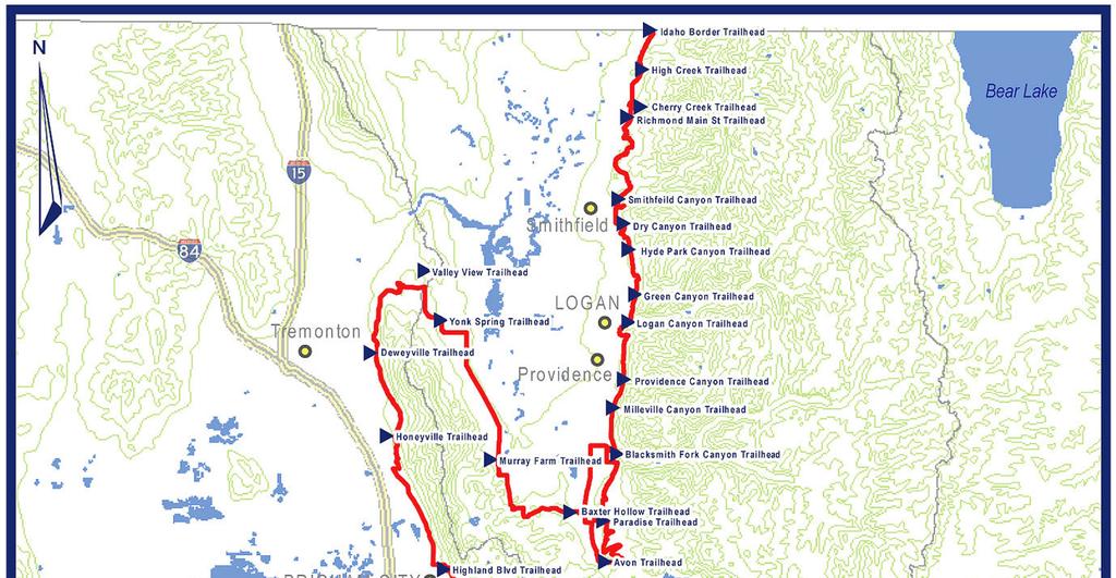
3 Section 1 Introduction The Bonneville Shoreline Trail has been designated as Utah's Millennium Legacy Trail, as part of a White House initiative on the basis of our Governor's recommendation and the Utah Legislature recognized the trail during the 1999 General Session. The vision of the BST is a non-motorized trail that serves as an interface between the urban area and public lands along the Wasatch Front and will provide trail users with a recreational experience at a distance from motorized activities that is both safe and aesthetically pleasing. The Bonneville Shoreline Trail Coalition is an organization of entities, both citizen and governmental, representing the communities in Utah involved in promoting, planning and building the Bonneville Shoreline Trail (BST). This report show the progress made in 2012 along the length of the trail. Work on the trail is performed by the different city, county and federal jurisdictions through which it passes. Cache County Box Elder County 35 0 Weber County Davis County Salt Lake County Utah County BST Total Miles
4 Bonneville Shoreline Trail Coalition Annual Report
5 Section 2 Progress Reports BST Committee General Efforts Jim Byrne Bonneville Shoreline Trail Committee Dave Roth Bonneville Shoreline Trail Committee The Bonneville Shoreline Trail Committee (BSTC) is a member of the Bonneville Shoreline Trail Coalition and focuses its efforts in Salt Lake County. The BSTC has continued to work recruiting volunteers and coordinating efforts among coalition members. The BST volunteer mailing list now has 615 members. The list is used to direct volunteers to opportunities with our partners along the length of the trail and to inform trail users about trail detours and closures. The BSTC organized nine trail work days during 2012 on the newest segment of the BST on the north slope of Mount Olympus; 219 volunteers provided 876 volunteer hours. The BSTC provided crew leaders and tools for volunteers and the Wasatch Mountain Club donated breakfast at each event. For information about the BST contact Dave Roth at or bonnevilleshorelinetrail@gmail.com or contact Jim Byrne at or jim.byrne@yahoo.com. 4


6 Bonneville Shoreline Trail Coalition Annual Report 2012 County by County Progress Reports Cache County AJ Luce North Logan City Russ Akina Logan City Josh Runhaar Cache County Logan Trail Connections Logan City completed a trail connection from the BST at the north tunnel entrance on U.S. Hwy 89 with Ray Hugie Hydro Park located next to the Logan River at the mouth of Logan Canyon. This link provides for a safe route off the adjacent highway for trail users. This connection will be linked with another section of trail in Logan Canyon to the River Trail, one of the city s most popular trails. In November 2012, Cache County installed a new pedestrian bridge over the Logan River. The remaining step to complete the trail connection is to construct a walkway under the highway including retaining walls to ensure the trail s safety during high water seasons. Construction is expected to be complete in Logan BST Temporarily Closed The BST was closed beginning October 1st to accommodate the construction of a concrete box culvert for an existing canal in the area. The trail was closed from U.S. Highway 89/91 to the Lundstrom Park through the spring Its closure is meant to protect the public from construction and heavy equipment. BST Connected to Lundstrom Park A new trail access connection was completed at approximately the midpoint between Logan Canyon and Green Canyon. This access point can be found on the east side of Lundstrom Park, 1600 East 1350 North, Logan. 5

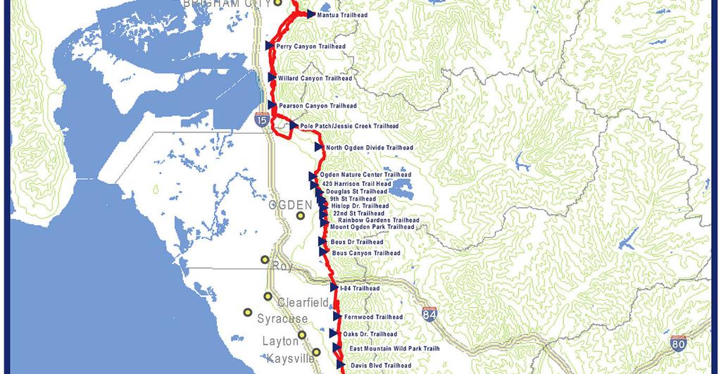
7 North Logan There is a 20 lot development planned that should be installing a portion of the upper branch of the BST over the next two years. The development borders the Naomi Wilderness. The community will feature connections to the Power line Trail and the Bonneville Shoreline Trail and will also have large open space areas. Cache County For more information about BST planning in Cache County, contact Josh Runhaar at (435) or Josh.Runhaar@cachecounty.org. Box Elder County Kristy Law Brigham City Brian Carver Bear River Association of Governments No progress to report for Box Elder County 35 0 For more information about BST planning in Box Elder County, contact Brian Carver at (435) or brianc@brag.utah.gov. Weber County Geoffrey Ellis - Weber Pathways Meg Krusemark - Weber Pathways New Trail in Rocky Mountain Power Corridor In North Ogden a new trail alignment was designed and constructed for the BST. This new section of trail runs from the North Ogden Divide to Pole Patch Dr. in Pleasant View, about 4 miles, within the 200 ft wide power line corridor owned by Rocky Mountain Power. This new section roughly parallels the power line road that was designated as part of the BST in 2006; unfortunately, the road is extremely rugged and steep in many places, with 6

8 grades up to 20%. Construction occurred mid-september through December. Final construction of the trail will begin again in the spring of Design and construction of this new section of trail were completed by IMBA along with local volunteers. The project was aided by a bequest from Ruth Orton, a donation from the Satterthwaite family, and by the use of Weber County impact fees. Snowbasin ski resort donated the use of its Sweco trail cat and Wasatch Civil Engineering provided free surveying services to identify property boundaries. Weber Pathways is also working with Pleasant View City on a possible trail head location, so that the trail can be accessed at its western terminus. BST South Connector Construction has begun on a new trail through the Washington Heights Church property in South Ogden. The new route will replace an existing section of trail that encroaches on private property and is too steep. The new trail will be a wellconstructed single track, with a maximum grade of 8%, which will tie into a loop trail on the church property. Most of the brush cutting has been completed, and Ogden City has offered the use of its new trail cat to cut the tread, with follow-up work to be done by hand. South Weber Planning Weber Pathways BST South Committee has been exploring the possibility of a foothill route between Beus Canyon and Weber Canyon. Four large parcels of land have been identified as being necessary for any feasible trail route, whether located high or low on the mountain. Attempts have been made to contact the property owners about the purchase of land or easements, but there has been no positive response to date. Weber County For information about BST planning in Weber County, contact Mark Benigni, Weber Pathways Executive Director, (801) or wp@weberpathways.org. 7

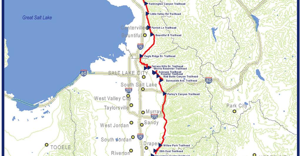
9 Davis County Scott Hess Davis County Trails Committee South Davis Planning The BST in southern Davis County is currently a BST connector designated as a sidewalk along Bountiful Boulevard. Davis County, Bountiful and North Salt Lake are working together to move the trail into the foothills east of development. Davis County hired Logan Simpson Design to determine a trail alignment and perform an impact study for the trail. In October the contractor began scouting the 9 miles between the Wild Rose Trail and the Bountiful "B". Some of the property through that stretch is privately owned, while other stretches are part of the Wasatch-Cache National Forest. Centerville Repairs Weber Basin Water Conservancy District worked on re-establishing the washed out section of the firebreak road, on the north side of Ricks Creek. The firebreak road serves as the BST alignment in the area. Sever rain storm events had eroded the road to the point that it was impassable. Farmington reroute An Eagle Scout project was done to reroute the Bonneville Shoreline Trail around a new reservoir in the Shepard Heights area. Davis County For information about BST planning in the Davis County portion, contact Scott Hess at or shess@daviscountyutah.gov. Salt Lake County Scott Earl- Sandy City Parks and Recreation Brad Jensen- Draper City Angelo Calacino- Salt Lake County 8


10 Bonneville Shoreline Trail Coalition Annual Report 2012 Land Donation Descendants of real estate developer M. Kenneth White donated almost 18 acres to Salt Lake County, land that wraps around the base of Grandeur Peak immediately south of Parleys Canyon. The three parcels just above the highest houses on the east bench near 3300 South will allow the BST to be extended by a third of a mile. The parcels are directly south of 14 acres the county owns at the mouth of Parleys Canyon. An outside appraisal valued the property at $205,000. Though this stretch has long been unofficially part of the path, now the county can officially maintain and improve the trail. To continue the trail farther south to Millcreek Canyon, the county must first obtain properties or simple easements from several property owners. Mount Olympus Salt Lake County and the U.S. Forest Service continued work on the BST from Mt. Olympus to the Z Trail. Approximately 80% of this 2.5 mile section of trail section is complete, and the balance will be completed in Crews from the U.S. Forest Service and Cottonwood Canyons Foundation spent weeks on the trail, sawing the corridor, moving rock and cutting in the trail. They were supported by the BST Committee which organized nine trail work days providing 876 volunteer hours. The largest volunteer work day was National Trails Day, with 75 volunteers and over 30 staff from supporting organizations. The event was held with the US Forest Service, Cottonwood Canyons Foundation, Salt Lake County and the local REI store. REI provided lunch and t-shirts, the BSTC provided breakfast, Salt Lake County provided shuttles from the park and ride lot, while the Forest Service and Cottonwood Canyons Foundation provided the crew leaders and tools. In October 2012 alignment work began on the next section of trail which will run north from the Z Trail to Neff s Canyon, a distance of about 2 miles. 9


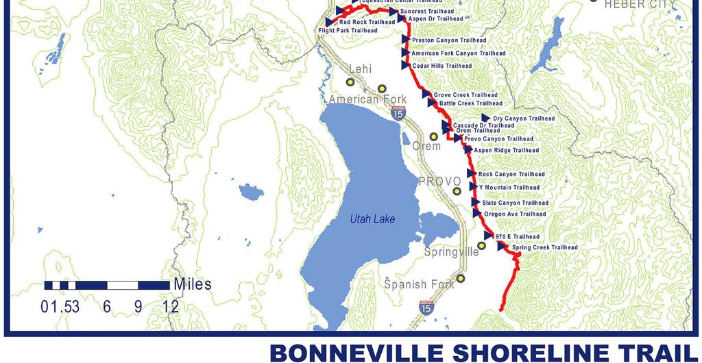
11 Sandy Trail Extension A proposal to extend the Bonneville Shoreline Trail from Hidden Valley Park by an additional 3.15 miles to Bell Canyon was presented to the Sandy City Council. Sandy City hired Project Engineering Consultants to survey the area and draw up a map with the proposed trail. The proposed trail would cross over several privately-owned land sections, land owned by Draper Irrigation and by the U.S. Forest Service. Funding for the project is still uncertain; a recent city trails survey found that most residents favor paying an additional $1to $3 a month with their utility bill as a trail impact fee. Holladay The City of Holladay owns 15 acres of land abutting USFS land that it plans to use for the BST. The City is planning on how to direct people to the BST through the city and possibly create links with mass transit. They are looking for funding for trailheads in cooperation with Cottonwood Heights. H Rock Salt Lake Parks and Public Lands did work during the summer with volunteers at the H-Rock section of the BST off of Devonshire Drive. They continue to work with community members and Highland High to care for this section of the BST and the conservation area this section of the trail runs through. Salt Lake County For information about BST planning in Salt Lake County, contact Angelo Calacino at or acalacino@slco.org. 10
12 Utah County Kerry Smith Utah Rocky Mountain Bikers Jim Price Mountainland Association of Governments Micron Master Plan Micron's new master plan was adopted. The plan calls for connections to the Bonneville Shoreline Trail. Utah County For information about BST planning in the Utah County portion, contact Jim Price at , or Max Mitchell at , 11
13 Section 3 About the Bonneville Shoreline Trail Coalition Background Trustees The Bonneville Shoreline Trail Coalition is an organization of entities, both citizen and governmental, representing the communities in Utah involved in promoting, planning and building the Bonneville Shoreline Trail (BST). The Coalition was formed on an ad hoc basis in 2001, and formalized and incorporated in Dave Rayfield Cache Trails Coalition Barry Burton Davis County Trail Committee Jim Byrne Bonneville Shoreline Trail Committee Geoff Ellis Weber Pathways Jim Price Mountainland Association of Governments Organization Members Bear River Association of Governments (BRAG) Brigham City Bountiful City Cache County Cache Metro Planning Organization Cache Trails Coalition Centerville City City of Logan North Logan City North Ogden City Utah Conservation Corps South Weber City Layton City Kaysville City Fruit Heights City Davis County Farmington Trails Committee City of North Salt Lake Salt Lake County Bonneville Shoreline Trail Committee Salt Lake County Draper City Sandy City Holladay City Salt Lake City Cottonwood Heights City Herriman City Mountainland Association of Governments (MAG) Provo City Orem City Weber Pathways Ogden Trails Network Ogden City Weber County Planning Department State Division of Parks & Recreation U. S. Forest Service Natural Resources Conservation Service (NRCS) & Great Salt Lake RC&D The Trust for Public Land Utah Rocky Mountain Bikers 12
Section 1 Introduction
 BST Coalition Annual Report 2014 Section 1 Introduction The Bonneville Shoreline Trail has been designated as Utah's Millennium Legacy Trail, as part of a White House initiative on the basis of our Governor's
BST Coalition Annual Report 2005
 BST Coalition Annual Report 2005 I. Introduction The Bonneville Shoreline Trail Coalition (Coalition) is an organization of entities, both citizen and governmental, representing the communities in Utah
2040 RTP TRANSIT PROJECT LIST
 2040 RTP TRANSIT LIST Phase 1 North Ogden - Salt Lake Corridor (North) -- First of Three Phases North Ogden - Ogden Intermodal Center - Ogden CBD - Newgate Mall - Riverdale - Clearfield - Hill Air Force
HEBER EXCLUSIVE LISTING HEBER CITY, WASATCH COUNTY, UTAH
 HEBER 12.62 EXCLUSIVE LISTING HEBER CITY, WASATCH COUNTY, UTAH SIZE ±12.62 acres PRICE $1,200,000 PARCELS APN: OWC-1733-0-010-045 ALTAPN: 00-0009-3026 DRIVING DISTANCES SLC Int l Airport: 60 minutes Park
50 Largest U.S. Metropolitan Areas
 America s Racially : Opportunities and Challenges 50 Largest U.S. Metropolitan Areas Community types in the 50 largest metropolitan areas 39,333,003 2% 14,533,32 1,983,337 9% 10% 47,40,87 49,199,197 30,180,578
±10.23 ACRES MOUNTAIN VIEW CORRIDOR AB 71
 Bacchus Hwy ±10.23 ACRES MOUNTAIN VIEW CORRIDOR AB 71 Riverton Towne Center 12600 S EXCLUSIVE LISTING HERRIMAN, UTAH Hwy 13100 S 4000 W 13400 S 3600 W AB 85 AB 154 13800 S 2700 W Bluffdale 1300 W 13200
A CASE FOR COMPLETING THE JORDAN RIVER PARKWAY: A
 A CASE FOR COMPLETING THE JORDAN RIVER PARKWAY: A safe crossing at 9000 South and 850 West Proposed 9000 South Underpass Parkway Timeline Parkway, Trail, and Tourism Facts Blueprint Jordan River 1971 1973
PROPOSED ACTION South 3000 East Salt Lake City, UT United States Department of Agriculture
 United States Department of Agriculture Forest Service Uinta-Wasatch-Cache National Forest Salt Lake Ranger District 6944 South 3000 East Salt Lake City, UT 84121 801-733-2660 File Code: 1950/2300 Date:
1/2 ACRE LOTS STARTING AT $85,000 - ALL INFO INCLUDED WASATCH COUNTY, UTAH
 1/2 ACRE LOTS STARTING AT $85,000 - ALL INFO INCLUDED WASATCH COUNTY, UTAH Zachary Hartman zhartman@landadvisors.com 6443 North Business Park Loop Road, Suite 12, Park City, Utah 84098 ph. 801.573.9181
±20 ACRES AVAILABLE IN HIDEOUT, UT
 ±20 ACRES AVAILABLE IN HIDEOUT, UT EXCLUSIVE LISTING ZONING: MOUNTAIN ZONE 1 ERU PER ACRE Zachary Hartman zhartman@landadvisors.com 6443 North Business Park Loop Road, Suite 12, Park, Utah 84098 ph. 801.573.9181
SOUTHEASTERN BOX ELDER COUNTY 2017 ACTIVE TRANSPORTATION CONCEPT PLAN DRAFT
 SOUTHEASTERN BOX ELDER COUNTY 2017 ACTIVE TRANSPORTATION CONCEPT PLAN SIGNATURE PAGE The following communities have participated in this trail planning process and approve the Southeastern Box Elder County
Draper City Corner Canyon Regional Park Master Plan
 Draper City Corner Canyon Regional Park Master Plan Chapter One: Introduction Statement of Purpose for Corner Canyon Regional Park Corner Canyon is held in trust for present and future citizens of the
The Chu property is a 6.57 acre parcel located in the Town of Superior on the west side of McCaslin Boulevard. In 2014, the Town of Superior acquired
 1 The Chu property is a 6.57 acre parcel located in the Town of Superior on the west side of McCaslin Boulevard. In 2014, the Town of Superior acquired the Chu property for open space with a contribution
Non-motorized Trail Plan & Proposal. August 8, 2014
 Town of Star Valley Ranch, Wyoming and the Star Valley Ranch Association in partnership with the USDA Forest Service, Bridger-Teton National Forest, Greys River Ranger District Non-motorized Trail Plan
System Group Meeting #1. March 2014
 System Group Meeting #1 March 2014 Meeting #1 Outcomes 1. Understand Your Role 2. List of Revisions to Existing Conditions 3. Information Sources Study Area The Purpose of Mountain Accord is to Preserve
Bear Creek Habitat Improvement Project
 06/10/10 Bear Creek Habitat Improvement Project El Paso County, Colorado Pike National Forest and Colorado Springs Utilities Owned Land Report prepared by: Eric Billmeyer Executive Director Rocky Mountain
Thank you for the opportunity to comment on the proposed action to add trails and trailheads to the Red Rock District trail system.
 July 14, 2010 Jennifer Burns Red Rock Ranger District PO Box 20429 Sedona, AZ 86341 Flagstaff Biking Organization PO Box 23851 Flagstaff, AZ 86002 Dear Jennifer- Thank you for the opportunity to comment
Dixon Trail Construction - From the Top of the Mountain 2016 Interim Report Friends of Cheyenne Mountain State Park September 2 nd, 2016
 - Dixon Trail Construction - From the Top of the Mountain 2016 Interim Report Friends of Cheyenne Mountain State Park September 2 nd, 2016 Prepared by: Andy Riter, Program Coordinator, and Joe Lavorini,
MORGAN CREEK GREENWAY Final Report APPENDICES
 APPENDICES MORGAN CREEK GREENWAY Appendix A Photos of Existing Conditions in Trail Corridor Photos of existing conditions Main trail corridor - February 2009 Photos of existing conditions south bank Morgan
U.S.D.A. FOREST SERVICE KETCHUM RANGER DISTRICT 206 SUN VALLEY ROAD P.O. BOX 2356 KETCHUM, ID (208)
") U.S.D.A. FOREST SERVICE KETCHUM RANGER DISTRICT 206 SUN VALLEY ROAD P.O. BOX 2356 KETCHUM, ID 83340 (208) 622-5371 Road and Trail Report 05/8/2015 More trails opened in Greenhorn this week. Only high elevation
U.S.D.A. FOREST SERVICE KETCHUM RANGER DISTRICT 206 SUN VALLEY ROAD P.O. BOX 2356 KETCHUM, ID 83340 (208) 622-5371 Road and Trail Report 05/8/2015 More trails opened in Greenhorn this week. Only high elevation
46 PLAT READY LOTS IN MOUNTAIN GREEN
 46 PLAT READY LOTS IN MOUNTAIN GREEN EXCLUSIVE LISTING MORGAN, UTAH SIZE ±50.86 acres LOTS 46 lots PARCELS 00-0003-3330, 00-0005- 3056, 00-0075-2244 ZONING R1-20 DENSITY 0.97 Units/Acre COMMENTS Snowbasin
PROJECT OVERVIEW WHAT IS THE GENERAL PLAN? WHY UPDATE THE PLAN? THE GENERAL PLAN WILL: WASATCH CANYONS GENERAL PLAN UPDATE
 WASATCH CANYONS GENERAL PLAN UPDATE PROJECT OVERVIEW WHAT IS THE GENERAL PLAN? The General Plan establishes goals and policies as a basis for land use and development regulations, transportation planning,
To: Cam Hooley From: Trails 2000 Date: September 30, 2016 Re: Hermosa Comments. Dear Cam:
 ! To: Cam Hooley From: Trails 2000 Date: September 30, 2016 Re: Hermosa Comments Dear Cam: Trails 2000 is commenting on the Forest Service Management Plan for the Hermosa Creek Watershed Management Plan
Hoppers Footwear 91 E. 100 North American Fork, UT J & J Health Foods 191 South 500 East
 UT Hoppers Footwear 91 E. 100 North American Fork, UT 84003 801-756-4747 J & J Health Foods 191 South 500 East American Fork, UT 84003 801-756-8790 Wasatch Nutrition 62 South 360 East American Fork, UT
TAYLOR CANYON RANCH COLORADO - ROUTT COUNTY - STEAMBOAT SPRINGS
 TAYLOR CANYON RANCH COLORADO - ROUTT COUNTY - STEAMBOAT SPRINGS Tucked up against the steep valley shaped by Mt. Pau and rising to the Routt National Forest, Taylor Canyon Ranch is an easily accessible,
Trail Phasing Plan. Note: Trails in the Clear Creek Canyon area (Segments will be finalized in the future to minimize wildlife impacts
 Note: Trails in the Clear Creek Canyon area (Segments 2 5 and a future JCOS connection) will be finalized in the future to minimize wildlife impacts Trail Phasing Plan P Parking 3 Easy Trail Intermediate
*Maple Mtn. *Olympus *Timpanogos **Granger
 Proposed 2019 21 UHSAA Alignment (Excludes Schools who are Activities Only) Alignment For All Sports Except Football 6A 31 5A 22 4A 27 3A 22 2A 23 1A 24 American Fork *Box Elder *Ben Lomond *Juab *Beaver
Table of Contents. page 3 Long term Goals Project Scope Project History. 4 User Groups Defined Trail Representative Committee. 5 Trail Users Breakdown
 Launched April 27th, 2010 1 Table of Contents page 3 Long term Goals Project Scope Project History 4 User Groups Defined Trail Representative Committee 5 Trail Users Breakdown 13 Trail Users Desires 16
Logan Canyon Hiking Trail Guide
 C a c h e V a l l e y V i s i t o r s B u r e a u Logan Canyon Hiking Trail Guide Monique Beeley Legend Trail Location Guide WASATCH CACHE NATIONAL FOREST WILDERNESS PAVED WATER TRAILHEAD 9 Logan River
SEGMENT ASSESSMENT REPORT
 2017 SEGMENT ASSESSMENT REPORT SEGMENT 3: MT ROSE / TAHOE MEADOWS TO SPOONER SUMMIT REPORT SUMMARY This report is a compilation of information collected on the Tahoe Rim Trail during assessments performed
±10.23 ACRES MOUNTAIN VIEW CORRIDOR
 700 W 4000 W y Hw n a H e r rim Towne Center Riverton 1300 W 3600 W 12600UTH S EXCLUSIVE LISTING HERRIMN, 2700 W ±10.23 CRES MOUNTIN VIEW CORRIDOR 71 13200 S 13400 S 154 luffdale LOCTION The property is
CHAPTER 5. Chapter 5 Recreation Element
 CHAPTER 5 Recreation Element Chapter 5 Recreation Element The Recreation Element of the Meyers Area Plan is a supplement to the Recreation Element of the TRPA Regional Plan and the El Dorado County General
Auburn Trail / Ontario Pathways Trail Connector Feasibility Study Public Information Meeting Wednesday, August 22, 2012
 Auburn Trail / Ontario Pathways Trail Connector Feasibility Study Public Information Meeting Wednesday, August 22, 2012 Purpose of Feasibility Study Purpose Evaluate the feasibility of constructing a multiuse
Project Update Utah Water Users Workshop March 14, 2012
 Project Update Utah Water Users Workshop March 14, 2012 Jeffrey D. Budge, P.E. Operations and Engineering Manager Steven H. Cain Facilities and Lands Manager Organized in 1935 Deer Creek Division of the
Mickelson Connector Feasibility Study
 Friends of the Norbeck PO Box 2003 Rapid City, SD 57709 www.friendsofthenorbeck.org Summary Comments on the Mickelson Connector Feasibility Study Prepared by Brian Brademeyer Submitted to Wyss Associates
At the time, the portion of the line through Eagle County remains wholly under the ownership of Union Pacific Railroad (UP).
.") Chapter 5 The Railroad Corridor as a Trail Corridor The intent of this chapter is to identify how the rail corridor, if available for lease or purchase in all or part, could be incorporated into the core
Chapter 5 The Railroad Corridor as a Trail Corridor The intent of this chapter is to identify how the rail corridor, if available for lease or purchase in all or part, could be incorporated into the core
Trail Assessment Report
 Trail Assessment Report Trail Options for the Bear Creek Canyon located in Pikes Peak Ranger District, Pike National Forest and on Colorado Springs Utility Lands Due to the presence of a unique species
RUSHMORE CONNECTOR TRAIL PROPOSAL
 PURPOSE AND NEED Background The U.S. Forest Service, Black Hills National Forest (Forest Service) has received a special use permit application from the State of South Dakota Department of Game, Fish and
UNITED STATES OF AMERICA FEDERAL ENERGY REGULATORY COMMISSION. PacifiCorp Project No NOTICE OF INTENT TO FILE APPLICATION FOR NEW LICENSE
 UNITED STATES OF AMERICA FEDERAL ENERGY REGULATORY COMMISSION PacifiCorp Project No. 1744 NOTICE OF INTENT TO FILE APPLICATION FOR NEW LICENSE Pursuant to 18 C.F.R. 5.5, PacifiCorp notifies the Federal
EPPERSON INDUSTRIAL PARK
 EXCLUSIVE LISTING FUTURE INDUSTRIAL SITE ±680 ACRES SALT LAKE CITY, UTAH 3300 N Subject 40.54 acres 3200 W 550.46 acres 40.17 acres 2100 N 40.09 acres Sold Future State Prison Site ± 325 Acres Haul Road
DRAFT. Proposed near term changes MIDDLE CANAL TRAIL MIDDLE CANAL TRAIL. Safety Improvements. Stop Sign. Crosswalks. Stop Sign
 E 300 DR 300 W W 220 W 200 300 E Historic Cache County Canal Pathway W 260 E 200 IT MM SU D R YO CA W 150 SR 218 W 100 E 100 S 300 E S 200 E W 200 S S 1100 E E 120 S sunrise elementar y S 830 E S 100 E
COASTAL CONSERVANCY. Staff Recommendation March 25, 2004 SONOMA COUNTY COASTAL TRAIL, PHASE I. File No Project Manager: Richard Retecki
 COASTAL CONSERVANCY Staff Recommendation March 25, 2004 SONOMA COUNTY COASTAL TRAIL, PHASE I File No. 03-142 Project Manager: Richard Retecki RECOMMENDED ACTION: Authorization to disburse up to $455,000
Decision Memo for Desolation Trail: Mill D to Desolation Lake Trail Relocation
 for Salt Lake County, Utah Uinta-Wasatch-Cache National Forest Salt Lake Ranger District 1. Background The present location of the Desolation Trail (#1159) between Mill D and Desolation Lake follows old
9 TO 71 ACRES INDUSTRIAL
 700 N ± G r e a t 9 TO 71 ACRES INDUSTRIAL S a l t L a k e LAND 80 EXCLUSIVE LISTING MAGNA, SALT LAE COUNTY, UTAH LOCATION W 4100S and S 8000 W, Magna, Salt Lake AB 202 County, Utah SIZE ± 9 to 71 PRICE
PARK CITY PRESERVE SOLD OUT!
 PARK CITY PRESERVE SOLD OUT! PARK CITY, UTAH WWW.PRESERVEPARKCITY.COM NEIGHBORHOOD INFOMATION Luxury Gated Community in Park City, Utah Elevation 6,400 to 7,900 looking at the Uinta Mountains Original
Blue River Trail Master Plan JSA to Town Hall June 2004
 Blue River Trail Master Plan JSA to Town Hall June 2004 Prepared for: Silverthorne Town Council Silverthorne SPORT Committee Department of Recreation and Culture Silverthorne Public Works Silverthorne
September 14, Comments of the Colorado Trail Foundation On the USFS Scoping Notice of August 13, 2010 RE: the relocation of the CDNST/CT Page 1
 THE COLORADO TRAIL FOUNDATION Comments on the U.S. Forest Service Scoping Notice of August 13, 2010 Regarding the Relocation of THE COLORADO TRAIL AND CONTINENTAL DIVIDE NATIONAL SCENIC TRAIL From La Garita
Business Item No XXX. Proposed Action That the Metropolitan Council approve the Coon Creek Regional Trail Master Plan.
 Business Item No. 2015-XXX Metropolitan Parks and Open Space Commission Meeting date: July 7, 2015 For the Community Development Committee meeting of July 20, 2015 For the Metropolitan Council meeting
Preferred Recreation Recommendations Stemilt-Squilchuck Recreation Plan March 2018
 Preferred Recreation Recommendations Stemilt-Squilchuck Recreation Plan March 2018 Below are the recommended recreation ideas and strategies that package together the various recreation concepts compiled
FOX HOLLOW MPC EXCLUSIVE LISTING SARATOGA SPRINGS, UTAH. LOCATION Redwood Road at Village Parkway in Saratoga Springs, Utah. PRICE Submit all Offers
 FOX HOLLOW MPC EXCLUSIVE LISTING SARATOGA SPRINGS, UTAH LOCATION Redwood Road at Village Parkway in Saratoga Springs, Utah PRICE Submit all Offers SIZE ± 360 ZONING R-10 and MF-10 UNIT COUNT Neighborhood
Trails. Lois Jensen Nature Preserve is a 30 acre parcel on the north end of the city. It provides unspoiled wooded paths.
 Trails Lois Jensen Nature Preserve is a 30 acre parcel on the north end of the city. It provides unspoiled wooded paths. TRAIL S, PATHS, ROUTES AND CONNECTORS Citizen input pointed to trails, paths, bike
11. Recreational Trails and Pathways Needs
 11. Recreational Trails and Pathways Needs Background Walking, biking, hiking, in-line skating, canoeing, and other trail- and pathway-related activities are important to Boiseans. This importance is demonstrated
SOUTH INTERCHANGE AREA
 Santaquin City General Plan 1 Location and Characteristics The South Interchange Area of Santaquin is located west of Interstate 15 and south of 500 South (Figure 1). It includes properties already annexed
CHAPTER 4 -- THE LAND USE PLAN: DESCRIPTIONS AND POLICIES FOR THIRTEEN PLANNING AREAS
 CHAPTER 4 -- THE LAND USE PLAN: DESCRIPTIONS AND POLICIES FOR THIRTEEN PLANNING AREAS NORTH CENTRAL CAC AREA LITTLE VALLEY ROAD TO JUG HANDLE CREEK PLANNING AREA This planning area includes Cleone, Noyo,
Rogue Gorge (Mt. Stella) Roadless Area-- T30S R3E (primarily in portions of Sections 23, 26, 33, 34 & 35)
 Roadless Area-- T30S R3E (primarily in portions of Sections 23, 26, 33, 34 & 35)") Rogue Gorge (Mt. Stella) Roadless Area-- T30S R3E (primarily in portions of Sections 23, 26, 33, 34 & 35) Rogue River-Siskiyou National Forest--High Cascades Ranger District Upper, higher elevation trail
Rogue Gorge (Mt. Stella) Roadless Area-- T30S R3E (primarily in portions of Sections 23, 26, 33, 34 & 35) Rogue River-Siskiyou National Forest--High Cascades Ranger District Upper, higher elevation trail
1.2 Corridor History and Current Characteristics
 SECTION 1 Description and Background of Study Area 1.1 Introduction This preliminary engineering report was prepared for the Alaska Department of Transportation and Public Facilities (ADOT&PF). It is part
MOAB peopleforbikes.org/e-bikes
 emtb ADVENTURE MAPS MOAB peopleforbikes.org/e-bikes OVERVIEW Moab, Utah is a world-class mountain bike destination known for its vast, red sandstone landscapes nestled below the rising peaks of the La
April 10, Mark Stiles San Juan Public Lands Center Manager 15 Burnett Court Durango, CO Dear Mark,
 Mark Stiles San Juan Public Lands Center Manager 15 Burnett Court Durango, CO 81301 Dear Mark, We are pleased to offer the following comments on the draft San Juan Public Lands Center management plans
Mission. Purpose. Idaho Trails Association promotes the continued enjoyment of Idaho s hiking trails.
 The Idaho Trails Association (ITA) is a non-profit 501(c)3. Mission Idaho Trails Association promotes the continued enjoyment of Idaho s hiking trails. Purpose To facilitate the active enjoyment of Idaho
Kit Carson-Challenger Ridge Trail Project
 Kit Carson-Challenger Ridge Trail Project Project Accomplishments Report-USFS December 15, 2015 Photo courtesy of Justin Peterson 815 South 25 th Street, Suite 101 Colorado Springs, CO 80904 Dedicated
Coast to Coast Connector Summit
 Project Partners Welcome to the Coast to Coast Connector Summit Winter Garden, Florida City Hall October 1, 2014 1 Why are we here? Objectives 1. Inform key stakeholders on the current state of the C2C
South Colony Basin Recreation Fee Proposal
 South Colony Basin Recreation Fee Proposal Purpose and Need for Collecting Fees in South Colony Basin: Forest Service appropriated funds have not been sufficient to maintain current recreational services
Kit Carson-Challenger Ridge Trail Project Annual Performance Report-2014 October 22, 2014
 1 Kit Carson-Challenger Ridge Trail Project Annual Performance Report-2014 October 22, 2014 Willow Lake and Kit Carson Peak 2 SUMMARY The Rocky Mountain Field Institute began Phase 1 of a multi-phase,
Road and Trail Report 05/25/2015
 U.S.D.A. FOREST SERVICE KETCHUM RANGER DISTRICT 206 SUN VALLEY ROAD P.O. BOX 2356 KETCHUM, ID 83340 (208) 622-5371 Road and Trail Report 05/25/2015 Trail and Road conditions remain much the same as last
Avalanche Hazard Investigations, Zoning, and Ordinances, Utah, Part 2
 Avalanche Hazard Investigations, Zoning, and Ordinances, Utah, Part 2 David A. Scroggin, Jack Johnson Company L. Darlene Batatian, P.G., Mountain Land Development ABSTRACT: The Wasatch Mountains of Utah
Wallace Falls State Park Classification and Management Planning Stage 3 Preliminary Recommendations July 18, 2018 Sultan City Hall
 Wallace Falls State Park Classification and Management Planning Stage 3 Preliminary Recommendations July 18, 2018 Sultan City Hall Thanks for coming! This document contains State Parks preliminary recommendations
Report to the Strategic Development Committee
 Report to the Strategic Development Committee Recommendation to Approve the Request of Virginia Department of Transportation for Easements across Washington Dulles International Airport Property at Route
Paul S. Sarbanes Transit in Parks Project Descriptions
 Paul S. Sarbanes Transit in Parks Project Descriptions ALASKA Denali National Park and Preserve Grant Amount: $246,000 The Denali National Park will test hybrid buses of various designs in order to determine
Bankhead Lake TWO PARCELS AND 1 LOT FOR SALE
 OVERVIEW NORTH PARCEL ACRES: 46 WATERFRONT: 1,227 Front Feet PRICE: $350,000 PER ACRE: $7574 PER FRONT FT. $285 SOUTH PARCEL ACRES: 22 WATERFRONT: 1,381 Front Feet PRICE: $295,000 PER ACRE: $13,170 PER
CITY OF LAFAYETTE CALIFORNIA. Trails Implementation Plan
 CITY OF LFYETTE CLIFORNI PURPOSE The Lafayette is a companion document to the Lafayette Trails Master Plan. The Implementation Plan is a working document intended to provide more current, and more fine-grained,
TOOELE MULTI-TENANT INVESTMENT OFFERING
 TOOELE MULTI-TENANT INVESTMENT OFFERING 54 South Main Street Tooele, Utah Sky Hazlehurst +1 801 837 2020 sky.hazlehurst@colliers.com Brad Brown +1 801 309 0399 brad.brown@colliers.com Colliers International
Growing and Changing with Utah. Winter 2018
 Growing and Changing with Utah 30 Consecutive Years UTAH S NUMBER ONE HOMEBUILDER Winter 2018 200 W Cranefield Estates Carlisle Traditional Model 3525 W. 2300 N., Clinton 801-985-5555 3500 W 5600 S 6000
Little River Trail Feasibility Study
 Final April, 2014 Prepared for the State Coastal Conservancy By the Natural Resources Services Division of Redwood Community Action Agency Table of Contents Executive Summary... 1 1. Project Purpose and
PLANNING COMMISSION AGENDA REPORT May 10, Members of the Planning Commission. Joyce Parker-Bozylinski, Contract Planner
 PLANNING COMMISSION AGENDA REPORT May 10, 2007 TO: FROM: PROPOSAL: APPLICANT: RECOMMENDATION: Members of the Planning Commission Joyce Parker-Bozylinski, Contract Planner Approval of the Calabasas Trails
13.1 REGIONAL TOURISM ISSUES AND SUMMARY OF FINDINGS
 13 REGIONAL TOURISM T he County of Mariposa s recreation needs and facilities fall within two categories: regional tourism and local recreation. This Element focuses on regional tourism issues related
CITY OF LAFAYETTE CALIFORNIA. Trails Implementation Plan
 CITY OF LAFAYETTE CALIFORNIA s Implementation Plan Version Date: November 27, 20063, 2013 PURPOSE The Lafayette s Implementation Plan is a companion document to the Lafayette s Master Plan. The Implementation
AB 172 AB 154 AB 68 AB 202 AB 201 AB 171 AB 111 AB 173 BEST NEW OPPORTUNITY IN MAGNA CITY MAGNA, SALT LAKE COUNTY, UTAH. Subject
 700 N MAGNA G r e a t ASCENT MPC S a l t L a k e 80 BEST NEW OPPORTUNITY IN MAGNA CITY MAGNA, SALT LAE COUNTY, UTAH AB 202 LOCATION W 4100S and S 8000 W, Magna, Salt Lake County, Utah SIZE ±71.75 acres
Hudson Highlands Fjord Trail Draft Master Plan. April 29, 2015
 Hudson Highlands Fjord Trail Draft Master Plan April 29, 2015 Agenda Route Overview Proposed Segment Results of Community Survey on that Segment Next Steps Municipal Endorsement Environmental Review Implementation
FEASIBILITY CRITERIA
 This chapter describes the methodology and criteria used to evaluate the feasibility of developing trails throughout the study areas. Land availability, habitat sensitivity, roadway crossings and on-street
SNOW AVALANCHES IN PROVO CANYON, UTAH
 SNOW AVALANCHES IN PROVO CANYON, UTAH KEVIN GRIFFITH REGION THREE AVALANCHE FORECASTER UTAH DEPARTMENT OF TRANSPORTATION 825 NORTH 900 WEST OREM, UTAH 84057-3958 USA (801 )-227-8000 TEL (801 )-227-8049
2. Goals and Policies. The following are the adopted Parks and Trails Goals for Stillwater Township:
 D. PARKS AND TRAILS 1. Introduction Stillwater Township s population is relatively low, with most residents living on rural residences on large lots. The need for active park space has been minimal in
Central Wasatch Visitor Use Study STEVEN W. BURR, PH.D. AND CHASE C. LAMBORN, M.S. INSTITUTE FOR OUTDOOR RECREATION AND TOURISM UTAH STATE UNIVERSITY
 Central Wasatch Visitor Use Study STEVEN W. BURR, PH.D. AND CHASE C. LAMBORN, M.S. INSTITUTE FOR OUTDOOR RECREATION AND TOURISM UTAH STATE UNIVERSITY Utah State University s Institute for Outdoor Recreation
The Recreational Trail along Cushing Park road has been a successful addition to the city
 The Recreational Trail along Cushing Park road has been a successful addition to the city Trails TRAILS, PATHS, ROUTES AND CONNECTORS Citizen input pointed to trails, paths, bike routes, and other non-motorized
USDA Trails Strategy WRI: ENGLISH PEAK SURVEY. Theodore Mendoza San Diego State University June 6 th 2016 August 18 th Advisor: Sam Commarto
 WRI: ENGLISH PEAK SURVEY Theodore Mendoza San Diego State University June 6 th 2016 August 18 th 2016 Advisor: Sam Commarto Klamath National Forest Submitted: March 21, 2017 Table of Contents Acknowledgements
Works Progress Administration photograph collection,
 Works Progress Administration photograph collection, 1930-1939 Overview of the Collection Title Dates Quantity Collection Number Summary Repository Access Restrictions Languages Works Progress Administration
White Mountain Wilderness Trails
 The area in which these hikes are located is rugged high mountain country along the Mogollon Rim. This famous eastwest escarpment separates Arizona's high plateau from the basin and range below. These
Trails, steps, & P-Patch to be south of I- 5 Colonnade
 UW Campus Trails, steps, & P-Patch to be south of I- 5 Colonnade Blaine and Howe Street steps REI N new lighting existing features connector trail new features or improvements overhead freeway and support
Blueways: Rivers, lakes, or streams with public access for recreation that includes fishing, nature observation, and opportunities for boating.
 Parks, Open Space and Trails PRINCE WILLIAM COUNTY 2008 COMPREHENSIVE PLAN TRAILS PLAN CONTENTS The components of the trails plan are: Intent Definitions Goals, Policies, and Action Strategies Trails Map
APPENDIX 5: JUNEAU NORDIC SKI CLUB MEMO
 APPENDIX 5: JUNEAU NORDIC SKI CLUB MEMO To all participants in the McDowell Eaglecrest nordic long-range planning meeting: It was good to meet with all of you last month and talk about our vision for the
Part Three : COMMUNITY PLAN AREAS AND SPECIAL STUDY AREAS SACRAMENTO 2030 GENERAL PLAN. Introduction
 Special study Areas Part Three : COMMUNITY PLAN AREAS AND SPECIAL STUDY AREAS SACRAMENTO 2030 GENERAL PLAN Introduction Beyond the boundaries of the 2030 General Plan, the City has defined Special Study
Santa Cruz North Interior
 Santa Cruz North Interior The Santa Cruz North Interior planning area includes the area commonly referred to as the San Lorenzo Valley. The greatest amount of development occurs in the communities of Boulder
PICTURE TH IS Summer/Fall 2015
 PICTURE THIS Summer/Fall 2015 Cranefield Estates Hamilton Model Home 3448 W. 2300 N., Clinton 801-985-5555 Yalecrest Towns 125 S. 3000 W., West Point 801-985-2200 Glen Eagle 1150 S. 3400 W., Syracuse 801-985-2200
C a c h e V a l l e y V i s i t o r s B u r e a u. Cache Valley. Cache valley biking guide. Photo by Monique Beeley
 C a c h e V a l l e y V i s i t o r s B u r e a u Cache Valley Cache valley biking guide Photo by Monique Beeley Legend # 18 7 17 16 6 5 4 1 15 3 2 10 9 11 8 12 13 14 Cache Valley road bike routes 1 LOGAN
Mazatzal Wilderness Trail Maintenance and Exploration
 Mazatzal Wilderness Trail Maintenance and Exploration March 15-19 (Wednesday - Sunday) Difficulty: Beginner Camping: Car Camping Mileage: Wednesday ~4 miles Thursday ~4-6 miles Friday ~4-6 miles Saturday
Friends of the Peak Board Meeting Minutes, August 14, 2012
 Friends of the Peak Board Meeting Minutes, August 14, 2012 Attending: Carol Beckman, Mike Cotter, Jim Strub, Eric Swab, Brian VanValkenburg. Meeting was called to order at 6:40 p.m. Minutes from the previous
US Forest Service Bears Ears Trail - NFST 1144 California Park to Hole in Wall Creek. Good (1) 2 3
 2 3") Trail Maintenance Endowment Fund Trail Criteria Form The Trail Maintenance Endowment Fund (TMEF) grant criteria form is used in determining the use of funds available on an annual basis. Decisions on how
Trail Maintenance Endowment Fund Trail Criteria Form The Trail Maintenance Endowment Fund (TMEF) grant criteria form is used in determining the use of funds available on an annual basis. Decisions on how
AGENDA ITEM 5 D WAKULLA ENVIRONMENTAL INSTITUTE (WEI) TRAIL FEASIBILITY STUDY
 TRAIL FEASIBILITY STUDY") March 19, 2018 AGENDA ITEM 5 D WAKULLA ENVIRONMENTAL INSTITUTE (WEI) TRAIL FEASIBILITY STUDY TYPE OF ITEM: Action STATEMENT OF ISSUE The Wakulla Environmental Institute (WEI) Trail is one of several trails
March 19, 2018 AGENDA ITEM 5 D WAKULLA ENVIRONMENTAL INSTITUTE (WEI) TRAIL FEASIBILITY STUDY TYPE OF ITEM: Action STATEMENT OF ISSUE The Wakulla Environmental Institute (WEI) Trail is one of several trails
VOLUME II APPENDIX F DETAILED PHYSICAL DESCRIPTION OF PROJECT RESERVOIRS AND LANDS
 VOLUME II APPENDIX F DETAILED PHYSICAL DESCRIPTION OF PROJECT RESERVOIRS AND LANDS THE CENTRAL NEBRASKA PUBLIC POWER AND IRRIGATION DISTRICT FERC PROJECT NO. 1417 PHYSICAL DESCRIPTION OF PROJECT LANDS
Section 3.6. Parklands & Recreation Areas
 Section 3.6: Parklands & Recreation Areas Section 3.6 Parklands & Recreation Areas 3.6 PARKLANDS AND RECREATION AREAS 3.6.1 Introduction to Analysis This section provides an overview of parklands and recreational
The Transportation Corridor Overlay District
 The Transportation Corridor Overlay District The Transportation Corridor Overlay District is a policy framework under which certain potentially beneficial development proposals may be considered, given