I-75 in Hamilton County Project Termini
|
|
|
- Cory King
- 5 years ago
- Views:
Transcription
1 I-75 in Hamilton County Project Termini Introduction As part of the North South Transportation Initiative (NSTI), capacity improvements were recommended for the I-75 corridor through Hamilton County from the Brent Spence Bridge on the south, where I-75 crosses into Kentucky, to I-275 on the north. The NSTI was a planning study conducted by the Ohio-Kentucky-Indiana Regional Council of Governments (OKI) that evaluated overall transportation needs at a broad level and considered substantial public input. ODOT has also recognized the need for capacity, access, and safety improvements on the I-75 corridor. ODOT s Highway Safety Program and the Congestion and Safety Initiative both identified major portions of the I-75 corridor for study to address capacity issues and high accident rates. Improvements to the I-75 corridor and its interchanges would be extremely expensive and unlikely to be pursued in entirety within the typical planning horizon of twenty years. According to the OKI Travel Demand Model, of the roughly 160,000 vehicles per day utilizing I-75 in Hamilton County, only about 25,000 (16%) are truly through-trips, with both the origin and destination north of I-275 or south of the Brent Spence Bridge. Therefore, ODOT believes that benefits may be provided to the majority of motorists even if only portions of the corridor are improved at any given time. In other terms, welldefined projects on I-75 within Hamilton County would have independent utility even if the entire corridor were not improved. The NSTI planning study considered the corridor only at a broad level, which did not allow for any detailed examination of needs or the impacts or benefits of any proposed solutions. Therefore, ODOT desires to consider the I-75 corridor in several specific, more detailed studies in order to develop a proposed program of projects for implementation of a span of many years. ODOT has identified three specific projects along the I-75 corridor that will be manageable for evaluation of needs and detailed consideration of alternative solutions, yet have logical termini, independent utility and are lengthy enough to consider environmental effects on a broad scale. 1

2 Overview of I-75 Corridor Projects 2
3 In order to illustrate these issues, the following summary for each project will demonstrate: The end points are at meaningful locations in the roadway network; and The project limits will be several miles in length through areas that have common environmental and social concerns, allowing for a meaningful examination of impacts. Please note that the three projects described below will be used for planning and environmental approvals. The improvements recommended by each of the three studies most likely will be further subdivided for design and construction according to availability of funding and maintenance of traffic needs. Brent Spence Bridge (HAM-71/ /0.22, PID 75119) The KYTC and ODOT are jointly planning for the replacement or widening of the Brent Spence Bridge, which conveys I-75 over the Ohio River between Kentucky and Ohio. The southern terminus was identified in coordination with the KYTC based upon the needed lanes over the bridge as well as plans for improvements to I-75 in Kentucky. The southern terminus is expected to be the 12 th Street Exit in Covington. Therefore, the study area will extend to the next interchange at Kyle s Lane. The northern terminus of this project will be the I-75 interchange with Western Hills Viaduct. Western Hills Viaduct is the first interchange north of the downtown area where connectivity is provided to a primary arterial both east and west of the freeway. South of this interchange, all of the connections are provided to local streets or to arterials that connect into the downtown area. This project will be 2.5 miles in length through Hamilton County. This portion of I-75 traverses the urban core of Cincinnati, ultimately joining with I-71 before crossing the Ohio River via the Brent Spence Bridge. This area is typical of a downtown freeway, with numerous closely spaced ramps. Connections are made to US 50, 5 th Street, 6 th Street, 7 th and 8 th Streets, 9 th Street, Freeman Avenue, Ezzard Charles Drive, and Findlay Street, all within less than two miles. This area is central city in character, with buildings located in close proximity to the right-of-way among a maze of ramp connections. According to 2000 census data, this area possesses a much higher population density than areas to the north, has more persons below poverty level, and more households with no vehicle available. These are factors that will be important in development of alternatives and consideration of impacts that are unique compared to adjacent sections. 3

4 This section is currently four-lanes in each direction. It is anticipated that one additional or possibly no additional through lanes will be constructed. The key issue in this section will be gaining capacity and safety improvements through reconfigurations of access and auxiliary lanes. Therefore, these access and safety improvements would not be expected to add to or influence congestion in adjacent sections and could therefore be constructed even if no additional improvements are made elsewhere. 4
 begins at the northern terminus of the Brent Spence Bridge project, just south of the I-75 interchange with Western Hills Viaduct.")
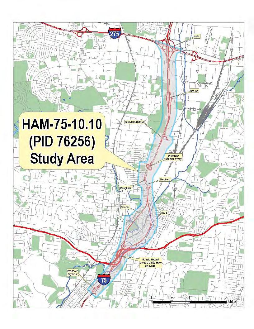
5 Mill Creek Expressway (HAM , PID 76257) The Mill Creek Expressway project (HAM ) begins at the northern terminus of the Brent Spence Bridge project, just south of the I-75 interchange with Western Hills Viaduct. The project ends just north of the Paddock Road interchange, for a total project length of approximately 7.8 miles. Beginning with Western Hills Viaduct, this section is the core of I-75, including interchanges with US 52 (Hopple Street), US 27 (Bates Avenue), I-74, Mitchell Avenue, SR 562 (Norwood Lateral), Towne Street, and SR 4 (Paddock Road). The northern terminus operationally would be expected to be the Norwood Lateral. The Norwood Lateral is the first freeway north of downtown connecting I-75 to I-71. However, the next two interchanges to the north (Towne and Paddock) are operationally linked and important to the relationship of the Norwood Lateral to I-75. Paddock Road, the last interchange south of the Cross County Highway, is a north-south route with connection at the first interchange on the Norwood Lateral east of I-75. Towne Street is a partial interchange just north of the ramp from the Norwood Lateral to I-75 northbound. Vehicles desiring to return southbound must use Towne Street to SR 4 (Paddock Road) to the Norwood Lateral and then back to I-75 southbound. Southbound I- 75 vehicles desiring to access the Towne Street area must use the Paddock Road exit. Because of this relationship, these interchanges are considered as a system and as a group form the northern terminus from an operational perspective. Therefore, the Paddock Road interchange is the northern terminus of the Mill Creek Expressway project. Northern Terminus of Mill Creek Expressway 5

6 In order to properly evaluate options at I-74/I-75, the study will also include the adjacent Colerain interchange on I-74. When improvements to an interchange are being considered, studies are required to evaluate the conditions to the next adjacent interchange. Therefore, traffic data will be collected and evaluated on I-75 from the Western Hills Viaduct to Paddock Road, on I-74 from the Montana Avenue interchange to I-75, and on the Norwood Lateral from I-75 to the Paddock Road interchange. 6
7 This section of I-75 has a different character from the Brent Spence Bridge project to the south. This area provides a larger distance between interchanges and gives very few connections to local streets. The majority of this section of I-75 abuts the railroad and a channelized section of Mill Creek on the west side of the right-of-way. Elsewhere, parks, cemeteries, and extreme slopes with known geotechnical challenges are adjacent to the roadway. There are portions of the roadway abutting residential areas and small communities of St. Bernard and Elmwood Place. South of I-74, I-75 has four lanes in each direction. From north of I-74, the roadway is currently three lanes in each direction. It is likely that proposed improvements would include the addition of at least one through lane in each direction and safety and operational improvements to existing access points. These improvements could be constructed without increasing the existing congestion levels in adjacent sections and therefore could be built independently. Through the Valley (HAM , PID 76256) The Through the Valley project begins at the northern terminus of the Mill Creek Expressway project, just north of Paddock Road and just south of the I-75 interchange with SR 126, the Ronald Reagan Cross County Highway. Operationally, the southern terminus is SR 126. It is a major east-west freeway spanning Hamilton County from I- 275 to US 22. The northern terminus is I-275, the outer beltway which completely encircles the greater Cincinnati area in both Ohio and Kentucky. Environmental approval is pending for improvements to I-275 in this area. This section is currently three lanes in each direction, with interchanges with SR 126, Galbraith Road, Davis Street/Cooper Avenue, Shepherd Lane, Industrial Distributor north and south, Glendale-Milford Road, Sharon Road, and I-275. This area is different in character from the adjacent section of I-75. The southern half, from the Cross County Highway to Shepherd Lane, is bifurcated it splits and surrounds Arlington Heights and portions of the Village of Lockland. The northern half has the community of Lincoln Heights on the west, and substantial areas of manufacturing and industrial development, including General Electric. The Through the Valley project is approximately 6.7 miles in length. With the volumes getting on and off I-75 from both SR 126 and I-275, this section could be improved to provide congestion and safety relief to traffic within this area without further increasing congestion problems to the south. Therefore, improvements could be constructed and have independent utility from adjacent sections. 7
8 8
District Construction Progr am. John R. Kasich, Ohio Governor Jerry Wray, ODOT Director Steve Mary, P.E., District Deputy Director
 District 8 2014 Construction Progr am Preble Greene Butler Warren Clinton Lebanon Hamilton Clermont Serving Butler, Clermont, Clinton, Greene, Hamilton, Preble and Warren Counties. John R. Kasich, Ohio
State Route 8 Corridor. Northern Summit County s Path to Success
 State Route 8 Corridor Northern Summit County s Path to Success Construction Guide: 2008-2009 State Route 8 corridor work description State Route 8 Corridor 10 projects $262 million With its close proximity
1.2 Corridor History and Current Characteristics
 SECTION 1 Description and Background of Study Area 1.1 Introduction This preliminary engineering report was prepared for the Alaska Department of Transportation and Public Facilities (ADOT&PF). It is part
Project Application. General Information ODOT PID. ODOT District. Primary County (3 char abrv)
") Current Status (Tier 1, Tier 2 or New) Proposed Status (Tier 1 or Tier 2) Project Application General Information ODOT PID ODOT District County (3 char abrv) Facility Name (i.e. route, rail, terminal,
Current Status (Tier 1, Tier 2 or New) Proposed Status (Tier 1 or Tier 2) Project Application General Information ODOT PID ODOT District County (3 char abrv) Facility Name (i.e. route, rail, terminal,
Project Deliverable 4.1.3d Individual City Report - City of La Verne
 Pomona Valley ITS Project Project Deliverable 4.1.3d Individual City Report - City of La Verne Prepared by: April 19, 2002 099017000.1 Copyright 2002, Kimley-Horn and Associates, Inc TABLE OF CONTENTS
PURPOSE AND NEED (CONCURRENCE POINT 1) NEW CANADA ROAD PROJECT FROM STATE ROUTE 1 (U.S. HIGHWAY 70) TO U.S. INTERSTATE 40
 NEW CANADA ROAD PROJECT FROM STATE ROUTE 1 (U.S. HIGHWAY 70) TO U.S. INTERSTATE 40") PURPOSE AND NEED (CONCURRENCE POINT 1) NEW CANADA ROAD PROJECT FROM STATE ROUTE 1 (U.S. HIGHWAY 70) TO U.S. INTERSTATE 40 Project Description The primary purpose of this project is to improve the major
PURPOSE AND NEED (CONCURRENCE POINT 1) NEW CANADA ROAD PROJECT FROM STATE ROUTE 1 (U.S. HIGHWAY 70) TO U.S. INTERSTATE 40 Project Description The primary purpose of this project is to improve the major
FNORTHWEST ARKANSAS WESTERN BELTWAY FEASIBILITY STUDY
 FNORTHWEST ARKANSAS WESTERN BELTWAY FEASIBILITY STUDY EXECUTIVE SUMMARY The 2030 Northwest Arkansas Regional Transportation Plan developed by the Northwest Arkansas Regional Planning Commission (NWARPC)
The Transportation Corridor Overlay District
 The Transportation Corridor Overlay District The Transportation Corridor Overlay District is a policy framework under which certain potentially beneficial development proposals may be considered, given
Project Application. General Information ODOT PID. ODOT District. Primary County (3 char abrv)
") Current Status (Tier 1, Tier 2 or New) Proposed Status (Tier 1 or Tier 2) Project Application General Information ODOT PID ODOT District Primary County (3 char abrv) Facility Name (i.e. route, rail, terminal,
Current Status (Tier 1, Tier 2 or New) Proposed Status (Tier 1 or Tier 2) Project Application General Information ODOT PID ODOT District Primary County (3 char abrv) Facility Name (i.e. route, rail, terminal,
HOV LANE PERFORMANCE MONITORING: 2000 REPORT EXECUTIVE SUMMARY
 Final Report Research Project Agreement No. T1803, Task 4 HOV Monitoring V HOV LANE PERFORMANCE MONITORING: 2000 REPORT EXECUTIVE SUMMARY by Jennifer Nee TRAC Research Engineer John Ishimaru TRAC Senior
Interstate 90 and Mercer Island Mobility Study APRIL Commissioned by. Prepared by
 Interstate 90 and Mercer Island Mobility Study APRIL 2017 Commissioned by Prepared by Interstate 90 and Mercer Island Mobility Study Commissioned by: Sound Transit Prepared by: April 2017 Contents Section
A. From I-68 in Monongalia County, West Virginia to SR 6119 in Fayette County, Pennsylvania 1
 Mon-Fayette Transportation Project A. From I-68 in Monongalia County, West Virginia to SR 6119 in Fayette County, Pennsylvania 1 The Mon/Fayette Transportation Project (MFTP) from I-68 in West Virginia
Section 106 Update Memo #1 Attachment D. Traffic Diversion & APE Expansion Methodology & Maps
 Section 106 Update Memo #1 Attachment D Traffic Diversion & APE Expansion Methodology & Maps I-65/I-70 North Split Interchange Reconstruction Project (Des. Nos. 1592385 & 1600808) Traffic Diversion and
5.1 Traffic and Transportation
 5.1 When it opens in 2009, the Bellevue Nickel Improvement Project will increase the number of vehicles able to travel through the study area, improve travel speeds, and improve safety by reducing the
HDR itrans Consulting Inc. 100 York Blvd., Suite 300 Richmond Hill, ON L4B 1J8 Tel: (905) Fax: (905)
 Fax: (905)") !" # $ !" # $ Consulting Inc. 100 York Blvd., Suite 300 Richmond Hill, ON L4B 1J8 Tel: (905) 882-4100 Fax: (905) 882-1557 www.itransconsulting.com November 2009 %&'('$&$ 1. West Brampton Road Network...
!" # $ !" # $ Consulting Inc. 100 York Blvd., Suite 300 Richmond Hill, ON L4B 1J8 Tel: (905) 882-4100 Fax: (905) 882-1557 www.itransconsulting.com November 2009 %&'('$&$ 1. West Brampton Road Network...
For Immediate Release Christine Girardin January 19, 2018 SUMTER COUNTY FLORIDA S TURNPIKE AND I-75 INTERCHANGE IMPROVEMENTS
 TRAFFIC ADVISORY For Immediate Release Christine Girardin 407-264-3069 January 19, 2018 Central and West Central Florida Weekly Lane Closures and Work Zone Advisory OCOEE Florida s Turnpike announces lane
Union Square. & Park Place. Project Summary Submitted by DeHoff Development Company
 Union Square & Park Place Submitted by DeHoff Development Company December 18, 2012 encompass a 250-acre, mixed-use corporate campus that includes office, hotel, retail and residential components. The
Project Location MP A44.5 MP A38 PRELIMINARY. A A57 (Future Project) A42 - A44.5 (Fall Fall 2019) A38 - A42. A31 - A38 - In Design
 A42 - A44.5 (Fall Fall 2019) A38 - A42. A31 - A38 - In Design") RECONSTRUCTION AND WIDENING PROJECT Project Location A44.5 - A57 (Future Project) MP A44.5 Steinsburg Road (Fall 2015 - Fall 2016) John Fries Highway (Fall 2017 - Fall 2019) A42 - A44.5 (Fall 2017 - Fall
RECONSTRUCTION AND WIDENING PROJECT Project Location A44.5 - A57 (Future Project) MP A44.5 Steinsburg Road (Fall 2015 - Fall 2016) John Fries Highway (Fall 2017 - Fall 2019) A42 - A44.5 (Fall 2017 - Fall
STAGE 2 & 3 Pavement reconstruction within viaduct footprint, pavement widening and resurfacing N/S of viaduct footprint, sidewalk
 STAGE 1 Viaduct removal, deck replacement on the River Bridge, and approach of the Chicago River Bridge north to Roscoe) Maintain local access roadways - 1 lane in each direction A signed alternate route
Report to the Strategic Development Committee
 Report to the Strategic Development Committee Request of Virginia Department of Transportation for Easements across Washington Dulles International Airport Property at Route 28 May 2016 PURPOSE Staff requests
FEASIBILITY STUDY REFINED CONCEPT 1 PROJECT A
 VIRGINIA DEPARTMENT OF TRANSPORTATION I-85 / I-95 INTERCHANGE FEASIBILITY STUDY REFINED CONCEPT 1 PROJECT A Columbia Rd REFINED CONCEPT 1 PROJECT A Bellevue Rd COST: $3.3M Siege Rd Eliminate the loop ramp
3. COLTA / HUGA CONNECTIONS - PRELIMINARY
 9 3. COLTA / HUGA CONNECTIONS - PRELIMINARY 3.1 COLTA The Chain of Lakes Trail Association (COLTA) trail, formerly identified as the Chester Spur Line, was completed and opened for use in June 2011. The
Northern Virginia District State of the District. Helen L. Cuervo, P.E. District Engineer October 18, 2017
 Northern Virginia District State of the District Helen L. Cuervo, P.E. District Engineer October 18, 2017 Susan Shaw, P.E., Megaprojects Director Virginia Department of Transportation American Society
Add-A-Lane Contract V. along a Section of I-95 includes 6 Bridges
 Newton Needham Chamber of Commerce Add-A-Lane Contract V along a Section of I-95 includes 6 Bridges Project File No. 603711 July 29, 2014 1 Agenda Project Update Overview Bid and Contract Award Schedule
Transportation Improvement District (TID) Exercise New Castle County Unified Development Code
 Exercise New Castle County Unified Development Code") Transportation Improvement District (TID) Exercise New Castle County Unified Development Code Churchmans Crossing TID How should New Castle County deploy Transportation Improvement Districts (TIDs)? Site
Transportation Improvement District (TID) Exercise New Castle County Unified Development Code Churchmans Crossing TID How should New Castle County deploy Transportation Improvement Districts (TIDs)? Site
DRAFT. Public Meetings November 7, 9, 15, Year UTP Planning Effort Cost/Revenue Matrix FY FY 2026
 Collin FM 2478 FM 1461 to US 380 (Prosper) US 380/McKinney Bypass Candidate Project; Collin Roadway Action Plan #3 $32,600,000 $32,600,000 A Collin FM 2514 East of Lavon Parkway to North of Drain Dr. Roadway
Ohio Department of Transportation Traffic Advisory. District 4 Allen C. Biehl, P.E., Deputy Director S. Arlington Road.
 Ohio Department of Transportation Traffic Advisory District 4 Allen C. Biehl, P.E., Deputy Director 2088 S. Arlington Road. Akron, Ohio 44306 www.transportation.ohio.gov/dist4 Friday, September 18, 2015
Concord Road Interchange. Standard hours of work
 Artist impression of the Concord Road interchange, Concord - concept only WestConnex s M4 East will extend the M4 Motorway with two new 5.5 kilometre tunnels from Homebush to Haberfield, providing a bypass
I-70/I-71 Project Public Meeting Presented By
 I-70/I-71 Project Public Meeting Presented By Ohio Department of Transportation ms consultants, inc. engineers, architects, planners MSI Design June 9, 2010 W e l c o m e Thom Slack Planning Administrator,
MEMORANDUM. Lynn Hayes LSA Associates, Inc.
 MEMORANDUM To: Lynn Hayes LSA Associates, Inc. Date: May 5, 217 From: Zawwar Saiyed, P.E., Senior Transportation Engineer Justin Tucker, Transportation Engineer I Linscott, Law & Greenspan, Engineers LLG
Major Projects Overview
 Major Projects Overview Miami-Dade Expressway Authority February 2018 About MDX MDX operates 5 roads in Miami Dade County SR 924, SR 112, SR 836, SR 874 and SR 878 MDX Primary Source of Revenue: User Fees-Tolls
Stage 2 ION: Light Rail Transit (LRT) from Kitchener to Cambridge
 from Kitchener to Cambridge") Stage 2 ION: Light Rail Transit (LRT) from Kitchener to Cambridge Public Consultation Centre (PCC) No. 3 Please Sign-in Cambridge City Hall November 21, 2017 2:00 to 8:00pm Preston Memorial Auditorium
Stage 2 ION: Light Rail Transit (LRT) from Kitchener to Cambridge Public Consultation Centre (PCC) No. 3 Please Sign-in Cambridge City Hall November 21, 2017 2:00 to 8:00pm Preston Memorial Auditorium
CLACKAMAS COUNTY BOARD OF COUNTY COMMISSIONERS. Policy Session Worksheet
 CLACKAMAS COUNTY BOARD OF COUNTY COMMISSIONERS Policy Session Worksheet Presentation Date: 10/10/17 Approx. Start Time: 1:30 PM Approx. Length: 60 minutes Presentation Title: An Update on the Sunrise Highway
4. Safety Concerns Potential Short and Medium-Term Improvements
 NH Route 104 Access Management Study Page 19 4. Safety Concerns Potential Short and Medium-Term Improvements Potential safety improvement strategies are listed by priority based on field observations by
FDOT Treasure Coast Traffic Impact Report March 25 through April 1, 2016
 March 25, 2016 Chuck McGinness, 954-777-4302 chuck.mcginness@dot.state.fl.us FDOT Treasure Coast Traffic Impact Report March 25 through April 1, 2016 TREASURE COAST Construction and maintenance-related
APPENDIX J MODIFICATIONS PERFORMED TO THE TOR
 APPENDIX J MODIFICATIONS PERFORMED TO THE TOR This appendix summarizes the modifications that were performed in years 2012 and 2017 to rectify calculation errors that were observed in the data presented
FDOT Treasure Coast Traffic Report through
 FDOT Treasure Coast Traffic Report 02 26 16 through 03 04 16 Kathleen Dempsey Fri 2/26/2016 2:56 PM To:Kathleen Dempsey ; 1 attachment 355 KB CR 714_Median Access Modifications.pdf;
Parking Amendments - Bay Street, between Harbour Street and Queens Quay West (York Street, Bay Street, and Yonge Street Ramp Removal)
") REPORT FOR ACTION between Harbour Street and Queens Quay West (York Street, Bay Street, and Yonge Street Ramp Removal) Date: October 26, 2017 To: Toronto and East York Community Council From: Acting Director,
REPORT FOR ACTION between Harbour Street and Queens Quay West (York Street, Bay Street, and Yonge Street Ramp Removal) Date: October 26, 2017 To: Toronto and East York Community Council From: Acting Director,
Yonge Street / Highway 401 Improvements Update. Public Works and Infrastructure Committee. General Manager, Transportation Services
 PW9.7 STAFF REPORT ACTION REQUIRED Yonge Street / Highway 401 Improvements Update Date: October 26, 2015 To: From: Wards: Reference Number: Public Works and Infrastructure Committee General Manager, Transportation
MEMORANDUM. Open Section Background. I-66 Open Section Study Area. VDOT Northern Virginia District. I-66 Project Team. Date: November 5, 2015
 MEMORANDUM To: VDOT Northern Virginia District From: I-66 Project Team Date: November 5, 2015 Subject: Open Section Background The purpose of this technical memorandum is to provide narrative and technical
Route 29 Solutions Projects
 Your guide to the Route 29 Solutions Projects For full details & continued engagement please visit www.route29solutions.org The Route 29 Solutions Package is a $230 million investment into the improvement
P3 & Design-Build. 101 st Annual THE Conference February 25 th, Speaker: Andrew Gensch, P.E.
 P3 & Design-Build 101 st Annual THE Conference February 25 th, 2015 Speaker: Andrew Gensch, P.E. Presentation Outline Ohio River Bridges Project Overall Discussion Downtown Crossing and East End Locations
2008 DEKALB COUNTY TRANSPORTATION PLAN (UPDATE)
") 2008 DEKALB COUNTY TRANSPORTATION PLAN (UPDATE) TABLE OF CONTENTS Introduction 1 Transportation Planning Activities 2 Identification of Problem Areas and Recommended Solutions 7 DeKalb County Projects
2008 DEKALB COUNTY TRANSPORTATION PLAN (UPDATE) TABLE OF CONTENTS Introduction 1 Transportation Planning Activities 2 Identification of Problem Areas and Recommended Solutions 7 DeKalb County Projects
FOR IMMEDIATE RELEASE Fiorella Teodista January 5, 2018 SOUTH FLORIDA AND TREASURE COAST WEEKLY LANE CLOSURES AND WORK ZONE ADVISORY
 TRAFFIC ADVISORY FOR IMMEDIATE RELEASE Fiorella Teodista 954-934-1130 January 5, 2018 SOUTH FLORIDA AND TREASURE COAST WEEKLY LANE CLOSURES AND WORK ZONE ADVISORY FORT LAUDERDALE Florida s Turnpike announces
ISSUE SUMMARY: FUNCTIONAL CLASSIFICATION NETWORK UPDATE FOR PRINCIPAL ARTERIALS
 Draft for approval by TCC on 8/8; TAQC on 8/14 and ARC on 8/27/14 DATE: August 27, 2014 ISSUE SUMMARY: FUNCTIONAL CLASSIFICATION NETWORK UPDATE FOR PRINCIPAL ARTERIALS FROM: Tom Worthan, TAQC Chairman
Pedestrian Safety Review Spadina Avenue
 STAFF REPORT ACTION REQUIRED Pedestrian Safety Review Spadina Avenue Date: October 13, 2015 To: Toronto and East York Community Council From: Director, Transportation Services, Toronto and East York District
FEDERAL HIGHWAY ADMINISTRATION NEVADA DEPARTMENT OF TRANSPORTATION ENVIRONMENTAL IMPACT STATEMENT RE-EVALUATION
 FEDERAL HIGHWAY ADMINISTRATION NEVADA DEPARTMENT OF TRANSPORTATION ENVIRONMENTAL IMPACT STATEMENT RE-EVALUATION Project Name: Boulder City/US 93 Corridor Study (Boulder City Bypass) Project Location: The
Important Lane Closures, April 3 9, 2011
 March 31, 2011 CONTACT: Marcia McAllister T: 703 572 0506 C: 571 730 9117 marcia.mcallister@dullesmetro.com Important Lane Closures, April 3 9, 2011 RESCHEDULED: Lane Shifts of Westbound Route 7 at Route
A VISION FOR I-95. January 12, Delaware Department of Transportation
 A VISION FOR I-95 January 12, 2011 Delaware Department of Transportation The East Coast s Main Street Along with SR 1, the most significant highway in Delaware 29 miles to I ".', 2 Sponsoring / Cooperating
Basic Project Information
 FY 2015-16 PROJECT DESCRIPTION FORM (2C) Submitting Agency: Loudoun County Basic Project Information Project Title: Loudoun County Parkway (VA Route 607) U.S. 50 to Creighton Rd. (2C) Project Type (check
Project Deliverable 4.1.3f Individual City Report - City of San Dimas
 Pomona Valley ITS Project Project Deliverable 4.1.3f Individual City Report - City of San Dimas Prepared by: April 19, 2002 099017000.1 Copyright 2002, Kimley-Horn and Associates, Inc TABLE OF CONTENTS
Capital Beltway HOT Lanes Project
 New Travel Choices Ahead Some things can t wait for traffic Capital Beltway HOT Lanes Project Project Update August 16, 2011 Major Milestones Reached Some things can t wait for traffic Project over 75%
Macleod Trail Corridor Study. Welcome. Macleod Trail Corridor Study Open House. Presentation of Proposed Design Concepts
 Macleod Trail Corridor Study Welcome Macleod Trail Corridor Study Open House Presentation of Proposed Design Concepts Study Purpose Develop a corridor plan for Macleod Trail that aligns with The City s:
I-35 Reconstruction Project
 I-35 Reconstruction Project Business Community Meeting McLennan County Projects Jodi Wheatley, I 35 Information Specialist, TxDOT John Jasek, PE, Waco Area Engineer, TxDOT Jacob Bell, PE, Project Manager,
Construction underway. STATUS: 229 5,190 5,419 5,305 STIP REFERENCE #FR /01/2013
 FREDERICK COUNTY STATE HIGHWAY ADMINISTRATION -- Frederick County -- Line 1 PROJECT: I-7, Baltimore National Pike INTERSTATE CONSTRUCTION PROGRAM DESCRIPTION: Widen I-7 east of MD 355 to east of MD 144
Navigating Indiana Road Signage
 Navigating Indiana Road Signage JOE BRUNO Traffic Administration Engineer Indiana Department of Transportation Presentation Overview Background Logo Program (Gas, Food, Lodging, & Camping Services) Attraction
MEMORANDUM. for HOV Monitoring on I-93 North and the Southeast Expressway, Boston Region MPO, November, 2011.
 MEMORANDUM Date: January 12, 2012 To: Congestion Management Process Files From: Seth Asante, Ryan Hicks, and Efi Pagitsas MPO Staff Re: Historical Trends: Travel Times and Vehicle Occupancy Levels for
A. CONCLUSIONS OF THE FGEIS
 Chapter 11: Traffic and Parking A. CONCLUSIONS OF THE FGEIS The FGEIS found that the Approved Plan will generate a substantial volume of vehicular and pedestrian activity, including an estimated 1,300
CHAPTER 4: ALTERNATIVES
 MSP Long Term Comprehensive Plan Update Metropolitan Airports Commission 4.1 INTRODUCTION CHAPTER 4: ALTERNATIVES Several alternatives were developed and evaluated based on their capability to meet the
Airport Planning Area
 PLANNING AREA POLICIES l AIRPORT Airport Planning Area LOCATION AND CONTEXT The Airport Planning Area ( Airport area ) is a key part of Boise s economy and transportation network; it features a multi-purpose
STUDY DESCRIPTION MEMORANDUM. DATE April 20, 2011
 DATE April 0, 0 TO FROM RE MEMORANDUM Congestion Management Program Files Ariel Godwin, CMP Manager Boston Region MPO Staff Limited-Access Highway Counts and Traffic Volumes, Summer 00 This memorandum
Other Principle Arterials Minor Arterial Major Collector Minor Collector Local
 CHAPTER 10 TRANSPORTATION Introduction The system of public roads in East Pikeland Township is decidedly rural in character. Since the 1984, the road network has remained much the same, with the addition
TRANSPORTATION ELEMENT
 Transportation TRANSPORTATION ELEMENT Data, Inventory, and Analysis Prepared by Contents 1.0 INTRODUCTION... 1 2.0 EXISTING CONDITIONS... 1 2.1 Roadways... 1 2.1.1 Jurisdiction... 1 2.1.2 Functional Classification...
Imagine the result. Bus Rapid Transit Feasibility Study. Laredo Urban Transportation Study. August 31 st, 2011
 Imagine the result Laredo Urban Transportation Study August 31 st, 2011 Bus Rapid Transit Feasibility Study Prepared for: Laredo Urban Transportation Study Prepared by: ARCADIS U.S., Inc. 2410 Paces Ferry
Memorandum. To: From: cc: Date: November 7, Re: 1.0 Purpose and Organization of this Addendum. 2.0 Project Description
 Memorandum To: From: cc: Laura Prickett, Horizon Water and Environment Analette Ochoa and Wana Chiu, WRECO Parag Mehta, Kimley Horn Date: November 7, 2017 Re: Santa Cruz Route 1 Tier I and Tier II HOV
Business Growth (as of mid 2002)
") Page 1 of 6 Planning FHWA > HEP > Planning > Econ Dev < Previous Contents Next > Business Growth (as of mid 2002) Data from two business directories was used to analyze the change in the number of businesses
Page 1 of 6 Planning FHWA > HEP > Planning > Econ Dev < Previous Contents Next > Business Growth (as of mid 2002) Data from two business directories was used to analyze the change in the number of businesses
DISTRICT EXPRESS LANES ANNUAL REPORT FISCAL YEAR 2017 JULY 1, 2016 JUNE 30, FloridaExpressLanes.com
 DISTRICT EXPRESS LANES ANNUAL REPORT FISCAL YEAR 2017 JULY 1, 2016 JUNE 30, 2017 FloridaExpressLanes.com This page intentionally left blank. TABLE OF CONTENTS List of Figures... ii List of Tables.... ii
Appendix 4.1 J. May 17, 2010 Memorandum from CTPS to the Inter Agency Coordinating Group
 Appendix 4.1 J May 17, 2010 Memorandum from CTPS to the Inter Agency Coordinating Group CTPS CENTRAL TRANSPORTATION PLANNING STAFF Staff to the Boston Region Metropolitan Planning Organization MEMORANDUM
INTERSTATE 395 EXPRESS LANES NORTHERN EXTENSION TRAFFIC & TRANSPORTATION TECHNICAL REPORT SEPTEMBER 2016
 INTERSTATE 395 EXPRESS LANES NORTHERN EXTENSION TRAFFIC & TRANSPORTATION TECHNICAL REPORT SEPTEMBER 2016 INTERSTATE 395 EXPRESS LANES NORTHERN EXTENSION Traffic and Transportation Technical Report City
Appendix L Technical Memorandum Aesthetics
 Technical Memorandum Aesthetics 1.0 AESTHETICS This section provides a discussion of the aesthetic resources in the vicinity of ARTIC. Aesthetics pertain to the elements that make a certain view pleasing
IMPACT OF NORTH-SOUTH TRAFFIC
 CIRCULATION ELEMENT WHITE PAPER NO. 4 IMPACT OF NORTH-SOUTH TRAFFIC INTRODUCTION Beverly Hills is not well served from a regional transportation accessibility standpoint. This is especially true in regard
Madison Metro Transit System
 Madison Metro Transit System 1101 East Washington Avenue Madison, Wisconsin, 53703 Administrative Office: 608 266 4904 Fax: 608 267 8778 TO: FROM: SUBJECT: Plan Commission Timothy Sobota, Transit Planner,
SANTA CLARA COUNTY I-280 CORRIDOR STUDY
 SANTA CLARA COUNTY I-280 CORRIDOR STUDY Appendix B 2 Technical Memorandum Existing Transportation Condition Memo SANTA CLARA VALLEY TRANSPORTATION AUTHORITY (VTA) 1-1 Introduction The I-280 Corridor Study
12, 14 and 16 York Street - Amendments to Section 16 Agreement and Road Closure Authorization
 REPORT FOR ACTION 12, 14 and 16 York Street - Amendments to Section 16 Agreement and Road Closure Authorization Date: April 27, 2018 To: Toronto and East York Community Council From: Senior Strategic Director,
395 Express Lanes Project Update
 395 Express Lanes Project Update Key Dates Milestone Date Limited Notice to Proceed February 2017 Early Works March-June 2017 Full Notice to Proceed July 2017 Preparatory Work Summer 2017 Draft Noise Abatement
Georgetown-Lewes Rail/Trail Study. Rail/Trail Study: Cool Spring to Cape Henlopen State Park New Road Extension (House Resolution No.
 Georgetown-Lewes Rail/Trail Study Rail/Trail Study: Cool Spring to Cape Henlopen State Park New Road Extension (House Resolution No. 47) August 22, 2011 Presentation Outline Background Benefits Statewide
SOUTHERN BELTWAY I-79 TO MON/FAYETTE EXPRESSWAY
 SOUTHERN BELTWAY I-79 TO MON/FAYETTE EXPRESSWAY Section 1 Purple Alternative (Revised: January 2007) I-79 to Mon/Fayette Expressway Purple Alternative Section 1 Photo Presentation Photo Presentation The
rtc transit Before and After Studies for RTC Transit Boulder highway UPWP TASK Before Conditions
 rtc transit Before and After Studies for RTC Transit UPWP TASK 3403-11-14 Before Conditions Report Boulder highway June 2011 Before and After Studies for RTC Transit BOULDER HIGHWAY BEFORE STUDY UPWP Task
ROUTE 630 DIVERGING DIAMOND INTERCHANGE
 ROUTE 630 DIVERGING DIAMOND INTERCHANGE Virginia Department of Transportation Contract Value and Dates Contract Value: $99,949,969.50 Start of Construction: Summer 2017 Final Completion Date: July 31,
SOUTH INTERCHANGE AREA
 Santaquin City General Plan 1 Location and Characteristics The South Interchange Area of Santaquin is located west of Interstate 15 and south of 500 South (Figure 1). It includes properties already annexed
April 4, 2014 Chuck McGinness, FDOT TREASURE COAST TRAFFIC REPORT April 4 through April 11, 2014
 April 4, 2014 Chuck McGinness, 954-777-4090 Chuck.McGinness@dot.state.fl.us FDOT TREASURE COAST TRAFFIC REPORT April 4 through April 11, 2014 TREASURE COAST Construction and maintenance-related lane closures
Westshore Development Forum April 9, 2014
 Florida Department of TRANSPORTATION Westshore Development Forum April 9, 2014 District Seven Secretary Paul Steinman Agenda D7 Overview Current Projects Future Projects Vision Florida Department of TRANSPORTATION
Project Application. General Information ODOT PID. ODOT District. Primary County (3 char abrv)
") Current Status (Tier 1, Tier 2 or New) Proposed Status (Tier 1 or Tier 2) Project Application General Information ODOT PID ODOT District Primary County (3 char abrv) Facility Name (i.e. route, rail, terminal,
Current Status (Tier 1, Tier 2 or New) Proposed Status (Tier 1 or Tier 2) Project Application General Information ODOT PID ODOT District Primary County (3 char abrv) Facility Name (i.e. route, rail, terminal,
This section evaluates the projected traffic operations and circulation impacts associated with the proposed upgrade and expansion of the LWRP.
 4.5 TRAFFIC AND CIRCULATION This section evaluates the projected traffic operations and circulation impacts associated with the proposed upgrade and expansion of the LWRP. 4.5.1 Environmental Setting Existing
user s guide to Transportation Improvements in Astoria Planning Efforts outside Astoria for more information, contact:
 The Miles Crossing/ Jeffers Garden transportation plan (underway), will identify needed improvements to the Warrenton Astoria Highway and local street improvements to serve expected growth in the Miles
Most people notice when ODOT builds something
 ODOT District 8 2016 Construction Program Taking Care of What We Have Most people notice when ODOT builds something new. However, we actually spend 93 percent of our time and resources taking care of what
Nashua Regional Planning Commission
 Nashua Regional Planning Commission Congestion Management Program Corridor Overview NH 111 is a major east-west arterial roadway that passes through 3 municipalities in the Nashua region. It enters the
FDOT Treasure Coast Traffic Impact Report October 9 through October 16, 2015
 From: Kathleen Dempsey To: Kathleen Dempsey Subject: FDOT Treasure Coast Traffic Report 10 09 15 through 10 16 15 Date: Friday, October 09, 2015 2:10:36 PM Attachments: image003.png CR 714_Median Construction
IRONTON-RUSSELL BRIDGE REPLACEMENT
 IRONTON-RUSSELL BRIDGE REPLACEMENT 2012-2016 District 9 Ohio Department of Transportation Ironton-Russell Bridge Replacement Existing Ironton-Russell Bridge Ironton-Russell Bridge Replacement Existing
Guide to. Road Construction Projects
 Guide to Road Construction Projects 2018 Spring is here and so is road construction season. This year PennDOT District 11-0 will invest an estimated $208 million on 68 projects to improve, preserve or
Research Report Agreement T4118, Task 24 HOV Action Plan HOV ACTION PLAN
 Research Report Agreement T4118, Task 24 HOV Action Plan HOV ACTION PLAN by John M. Ishimaru Senior Research Engineer Duane Wright Systems Analyst Programmer Mark E. Hallenbeck Director Jaime Kang Research
Susan Jones Moses Susan Jones Moses and Associates Glen Weisbrod Economic Development Research Group
 Susan Jones Moses Susan Jones Moses and Associates Glen Weisbrod Economic Development Research Group 2 SHRP2 C03: Interactions between Transportation Capacity, Economic Systems, and Land Use Economic Development
Electric System Serving Pierce County Current system and future investments. Janet Olsen Steve Botts
 Electric System Serving Pierce County Current system and future investments Janet Olsen Steve Botts Project Manager Real Estate t / Rights-of-Way April 13, 2011 Presentation overview Information requested
7272 WISCONSIN AVENUE LOCAL AREA TRANSPORTATION REVIEW
 7272 LOCAL AREA TRANSPORTATION REVIEW AND TRANSPORTATION POLICY AREA REVIEW MONTGOMERY COUNTY, MARYLAND Submitted on behalf of Carr Properties Prepared by: Wells + Associates, Inc. Submission: July 1,
TEMPE BEACH PARK - RECOMMENDATIONS
 TEMPE BEACH PARK - RECOMMENDATIONS Tempe Beach Park has the potential to become a regional destination park, but it suffers from a host of physical and operational problems, as well as structural flaws.
Traffic Analysis Final Report
 SR-71 Widening Project Project Approval/Environmental Documentation Traffic Analysis Final Report Prepared for Caltrans District 7 August 2012 6 Hutton Centre Drive, Suite 700 Santa Ana, California 92707
6 HIGH-OCCUPANCY-VEHICLE (HOV) LANES AND TRAVEL DEMAND MANAGEMENT (TDM) PROGRAMS
 LANES AND TRAVEL DEMAND MANAGEMENT (TDM) PROGRAMS") 6 HIGH-OCCUPANCY-VEHICLE (HOV) LANES AND TRAVEL DEMAND MANAGEMENT (TDM) PROGRAMS Travel demand management (TDM) programs enable roadways, which have a fixed capacity, to accommodate more travelers without
6 HIGH-OCCUPANCY-VEHICLE (HOV) LANES AND TRAVEL DEMAND MANAGEMENT (TDM) PROGRAMS Travel demand management (TDM) programs enable roadways, which have a fixed capacity, to accommodate more travelers without
Electric System Serving Pierce County Current system and future investments
 Electric System Serving Pierce County Current system and future investments Janet Olsen Project Manager Steve Botts Real Estate / Rights-of-Way April 13, 2011 Presentation overview Information requested
METRO Orange Line Update Metro Transit, BRT/Small Starts Projects Christina Morrison & Natalie Westberg Transportation Committee July 10, 2017
 METRO Orange Line Update Metro Transit, BRT/Small Starts Projects Christina Morrison & Natalie Westberg Transportation Committee July 10, 2017 Orange Line BRT Project What is the Orange Line project? 17-mile
Construction Update. ODOT District Two Construction Update. For Immediate Release Thursday, October 18, Lucas County
 Construction Update Contact: The District Two Public Information Office at (419) 373-4428 or email D02.PIO@dot.ohio.gov For Immediate Release Thursday, October 18, 2018 ODOT District Two Construction Update