GREEK TRANSBOUNDARY GROUND WATER BODIES WD EAST MACEDONIA (11)
|
|
|
- Benjamin Hill
- 5 years ago
- Views:
Transcription

1 GREEK TRANSBOUNDARY GROUND WATER BODIES WD EAST MACEDONIA (11)
.")
: Ano Poroia - Beles GWB - GR11FB080 Agistro GWB - GR110B020 Vrontous GWB - GR110B110")
2 In the Water District of East Macedonia (WD.11) determind fifteen (15) ground water bodys (GWB). They belong to the whole catchment of Strimonas river basin (GR.06). From the fifteen (15) GWB, four (4) charatcterized as transboundary ground water bodys (TGWB) and are the following (from west to east): Ano Poroia - Beles GWB - GR11FB080 Agistro GWB - GR110B020 Vrontous GWB - GR110B110 TRANSBOUNDARY GROUND WATER BODIES (GWB) Menikio - Falakro GWB - GR110B030

3 TRANSBOUNDARY GROUND WATER BODIES (GWB)
4 Ano Poroia - Beles GWB GR11FB080 Ano Poroia-Beles ground water body (GWB) is a fissure system. It belongs to Strymonas River Water Basin and its area is 287,22 km 2. In the GWB there is a number of contact fault springs. Springs water is used for drinking and irrigation. The fissure Ano Poroia Beles GWB GR11FB080 continues beyond the border of Greece to the Proterozoic Bulgarian GWB.

5 Ano Poroia - Beles GWB GR11FB080
6 Agistro GWB - GR110B020 Agistro ground water body (GWB) is a karstic system. It belongs to Strymonas River Water Basin and its area is 153,58 km 2. Precipitation is the main source of aquifer supply. In the GWB the discharge is carried out mainly from springs. Springs water is used for drinking and irrigation. The qualitative (chemical) and quantitative status is good. The karstic Agistro GWB - GR110B020 continues beyond the border of Greece to the karstic BG4G0000Pt1036 Bulgarian GWB.

7 Agistro GWB - GR110B020
8 Vrontous GWB GR110B110 Vrontous ground water body (GWB) is a fissure system. It belongs to Strymonas River Water Basin and its area is 436,72 km 2. Precipitation is the main source of aquifer supply. In the GWB there are a few springs. Springs water is used for drinking and irrigation. The qualitative (chemical) and quantitative status is good. The fissure Vrontous GWB- GR110B110 continues beyond the border of Greece to the Proterozoic BG4G0000C2020 Bulgarian GWB.

9 Vrontous GWB GR110B110
10 Menikiou - Falakrou GWB GR110B030 Menikio Falakro ground water body (GWB) is a karstic system. It belongs to Strymonas River Water Basin and its area is 1.007,61 km 2. Precipitation is the main source of aquifer supply. The qualitative (chemical) and quantitative status is good. The karstic Menikiou Falakrou GWB GR110B030 is not continue beyond the border of Greece

11 Menikiou - Falakrou GWB GR110B030
12 In the Water District THRACE (WD.12) determind eighteen (18) ground water bodys (GWB). From the eighteen (18) GWB, four (4) charatcterized as transboundary ground water bodys (TGWB) and are the following (from west to east): Orestiada GWB - GR12BT010 Potamoi - Stavroupoli GWB - GR120B090 Drosinio GWB - GR120B100 TRANSBOUNDARY GROUND WATER BODIES (GWB) Soufli - Didimoticho GWB - GR12BT150
13
14 Orestiadas GWB - GR12BT010 Orestiada ground water body (GWB) is an alluvial system. It belongs to Evros River Water Basin and its area is 835,16 km 2. Precipitation, Ardas and Evros rivers runoff are the main sources of aquifer supply.the annual renewable reserves are 60 x 10 6 m 3. In the GWB there is a big number of boreholes which are used for drinking and irrigation. The qualitative (chemical) and quantitative status is good. The alluvial Orestiada GWB GR12BT010 continues beyond the border of Greece to quaternary BG3G000000Q048 and to neogene BG3G000000N011 Bulgarian GWB.

15 Orestiada GWB - GR12BT010
16 Potamon Stavroupolis GWB GR120B090 Potamoi Stavroupoli ground water body (GWB) is a mixed (alluvial - karstic - fissure) system. It belongs to Nestos River Water Basin and its area is 2.416,34 km 2. Precipitation and Nestos river runoff are the main sources of aquifer supply. In the GWB system there are few boreholes and a number of contact fault springs which are used for drinking. The qualitative (chemical) and quantitative status is good. The mixed Potamon Stavroupolis GWB GR120B090 continues beyond the border of Greece to paleogene BG3G0000Pg3021 and proterozoic BG3G00000Pt039 Bulgarian GWB.
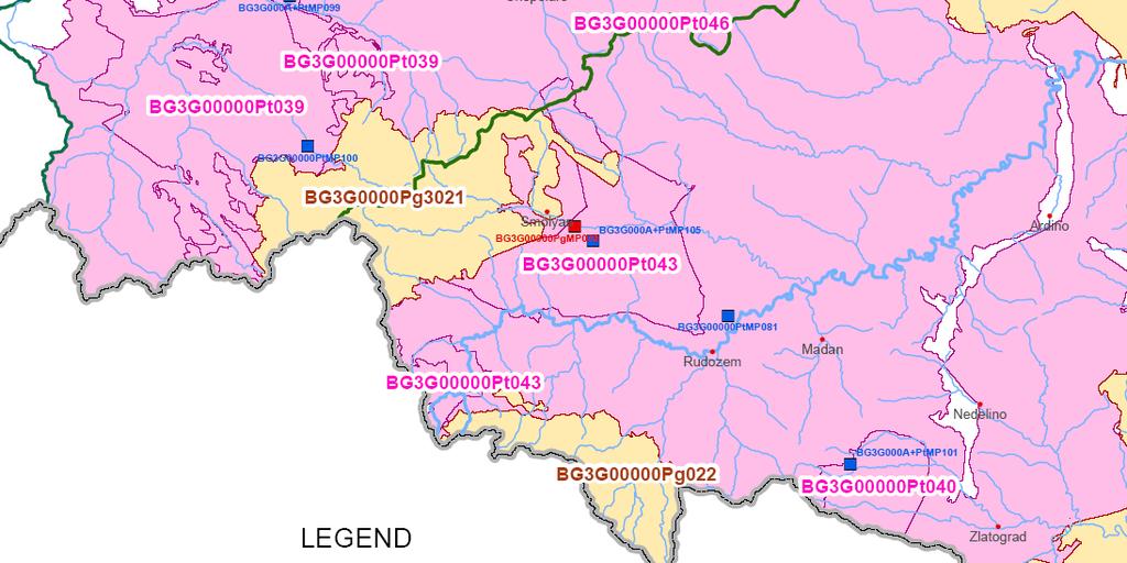
17 Potamoi Stavroupoli GWB GR120B090
18 Drosiniou GWB - GR120B100 Drosinio ground water body (GWB) is a fissure system. It belongs to Komotini-Loutro Evrou River Water Basin and its area is 976,53 km 2. Precipitation is the main source of aquifer supply. In the GWB there are number of springs which are used for drinking. The qualitative (chemical) and quantitative status is good. The fissure Drosinio GWB GR120B100 continues beyond the border of Greece to proterozoic BG3G00000Pt046 Bulgarian GWB.


19 Drosinio GWB - GR120B100
20 Soufliou - Didimotichou GWB GR12BT150 Souflio - Didimoticho ground water body (GWB) is a mixed (alluvial - fissure) system. It belongs to Evros River Water Basin and its area is 1.203,57 km 2. Precipitation, Erithropotamos and Evros river runoff are the main sources of aquifer supply. In the GWB there are boreholes which are used for drinking and irrigation. The fissure Souflio Didimoticho GWB GR12BT150 continues beyond the border of Greece to proterozoic BG3G00000Pt046 Bulgarian GWB.

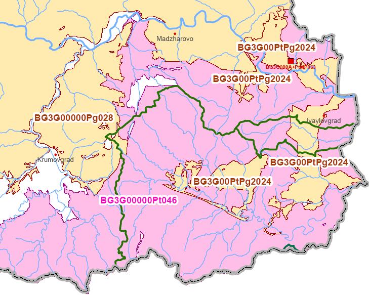
21 Soufliou - Didimotichou GWB GR12BT150
"Transboundary coordination according to the FD Directive in the shared river basins of Greece
 Workshop on Transboundary Issues Budapest March 31st April 1st "Transboundary coordination according to the FD Directive in the shared river basins of Greece Katerina Triantafyllou, ECOS Consulting S.A.
ORTHOLOGICAL MANAGEMENT OF HYDROLOGICAL RUNOFF BASINS OF THE PREFECTURE OF DRAMA (CURRENT SITUATION PROTECTIVE ACTIONS PERSPECTIVES)
") ORTHOLOGICAL MANAGEMENT OF HYDROLOGICAL RUNOFF BASINS OF THE PREFECTURE OF DRAMA (CURRENT SITUATION PROTECTIVE ACTIONS PERSPECTIVES) This paper presents the torrential environment of the torrents of the
ORTHOLOGICAL MANAGEMENT OF HYDROLOGICAL RUNOFF BASINS OF THE PREFECTURE OF DRAMA (CURRENT SITUATION PROTECTIVE ACTIONS PERSPECTIVES) This paper presents the torrential environment of the torrents of the
Seasonal Variability of the Groundwater Regime for Several Aquifers in Bulgaria Tatiana Orehova 1
 Seasonal Variability of the Groundwater Regime for Several Aquifers in Bulgaria Tatiana Orehova 1 The purpose of the paper is to analyse the seasonal variability of the groundwater regime for several aquifers
Transboundary and Not-Tranboundary Aquifers in the Basin
 Second Assessment of Transboundary Rivers, Lakes and Groundwaters under the UNECE Water Convention Transboundary and Not-Tranboundary Aquifers in the Basin Slovak Hydrometeorological Institute Bratislava,
Lead Beneficiary. Full Project Title A/A. PROJECT PROPOSALS APPROVED FOR FINANCING Integrated Tourism Approach For the c INTEGRA_TOUR
 2nd Call for project proposals of the CP INTERREG V-A Greece-Bulgaria 2014-2020 2nd phase evaluation results 2nd CALL FOR PROJECT PROPOSALS INTERREG V-A GREECE BULGARIA 2014-2020 Integrated Tourism Approach
The Timok River Basin in Serbia
 The Timok River Basin in Serbia UNECE Workshop on Integrated Transboundary Water Resources Management in SEE, Sarajevo, 18-20 May, 2009 Dragana Ninković, Dipl.-Ing. Dušan Dobričić, Dipl.-Ing. Content 1.
TRANSBOUNDARY COOPERATION ON WATER MANAGEMENT
 3 rd Istanbul International Water Forum European Regional Process towards the 7 th World Water Forum PLOVDIV TRANSBOUNDARY COOPERATION ON WATER MANAGEMENT Nicola Karnolski - Director of East Aegean Sea
WORKING PAPER In the context of the placement in the Observatory of the Egnatia Odos A.E.
 COMPARATIVE ANALYSIS OF POPULATION CHANGES IN THE AREAS CROSSED BY THE THREE BASIC ROAD AXES OF GREECE: THE EGNATIA MOTORWAY, THE PA.TH.E. AND THE IONIAN MOTORWAY WORKING PAPER In the context of the placement
How to develop resilient infrastructure (Global SDG9)
") How to develop resilient infrastructure (Global SDG9) 16-17 November 2017, Ljubljana, Slovenia Development of resilient rail infrastructure, practices in the Republic of Macedonia Darko Miceski Viktorija
How to develop resilient infrastructure (Global SDG9) 16-17 November 2017, Ljubljana, Slovenia Development of resilient rail infrastructure, practices in the Republic of Macedonia Darko Miceski Viktorija
October 17-19, 2011 Maria Laach, Germany. 2 nd CGS Europe Knowledge Sharing Workshop Natural Analogues
 NATURAL ANALOGUES IN SERBIA Snežana Komatina-Petrović 1. Geology of Serbia Complex geological structure. Satellite assemblage of Balkan and Apennines (Landsat-3 images). 1. Geology of Serbia Regional geological
MIÑO O AND LIMIA BASINS
 Miño-Sil MIÑO O AND LIMIA BASINS José Álvarez Díaz Sil River Basin District s s Planning Office, Spain WORKSHOP ON TRANSBOUNDARY WATER RESOURCES BUDAPEST, HUNGARY, 8-10 FEBRUARY 2011 INDEX 1. OVERVIEW
Notes on the geographic distribution and ecology of Salix xanthicola (Salicaceae)
") PHYTOLOGIA BALCANICA 12 (2): 209 213, Sofia, 2006 209 Notes on the geographic distribution and ecology of Salix xanthicola (Salicaceae) Knud Ib Christensen 1, Jerzy Zieliński 2 & Ana Petrova 3 1 University
PHYTOLOGIA BALCANICA 12 (2): 209 213, Sofia, 2006 209 Notes on the geographic distribution and ecology of Salix xanthicola (Salicaceae) Knud Ib Christensen 1, Jerzy Zieliński 2 & Ana Petrova 3 1 University
INSURED - INFORMATION SYSTEM FOR AN INTEGRATED AND SUSTAINABLE USE OF WATER RESOURCES OF DRINI-DRIM RIVER
 BALWOIS 2004 Ohrid, Macedonia, 25-29 May2004 INSURED - INFORMATION SYSTEM FOR AN INTEGRATED AND SUSTAINABLE USE OF WATER RESOURCES OF DRINI-DRIM RIVER Agim Selenica\ Miriam Boqdanl', Marc Morell 2, Josif
3.0 OVERVIEW OF HUECO BOLSON
 3.0 OVERVIEW OF HUECO BOLSON The Hueco Bolson covers about 2,500 square miles, or 1.6 million acres in New Mexico, Texas, and Chihuahua (Figure 3-1). In Texas, the Hueco overlies portions of El Paso and
Environmental management of big riverine floods: the case of Evros River in Greece
 Environmental management of big riverine floods: the case of Evros River in Greece Z. NIVOLIANITOU, B. SYNODINOU Institute of Nuclear & Radiological Sciences & Technology, Energy & Safety NCSR DEMOKRITOS
Υou are one step closer in getting the most out of the conference.
 Participants Guide Dear Participant, Υou are one step closer in getting the most out of the conference. Below you will find the program of the conference including a guide that will lead you through the
monitoring of egnatia motorways spatial impacts
 monitoring of egnatia motorways spatial impacts MINISTRY OF ENVIRONMENT, PHYSICAL PLANNING AND PUBLIC WORKS 1 A TOOL AT THE SERVICE OF SPATIAL DEVELOPMENT The Egnatia motorway Observatory monitors, and
The Isonzo/Soca river basin
 Geneva September 8 th 2014 The Isonzo/Soca river basin Status and perspective on the possible Alpine river basin to be assessed The Alpine Convention Water management, risk management and adaptation to
2.2. Greece Greece - geography
 2.2. Greece 2.2.1. Greece - geography The Greek Peninsula is located at Europe's southeastern end. It stretches between the 34 th and 41 st parallel and borders Albania (NW), Bulgaria and FYROM (N), Turkey
DETECTION OF WATER LEAKS IN FOUM EL-GHERZA DAM (ALGERIA)
") Ninth International Water Technology Conference, IWTC9 2005, Sharm El-Sheikh, Egypt 581 DETECTION OF WATER LEAKS IN FOUM EL-GHERZA DAM (ALGERIA) N. Hocini and A.S. Moulla Applied Hydrology and Sedimentology
Ninth International Water Technology Conference, IWTC9 2005, Sharm El-Sheikh, Egypt 581 DETECTION OF WATER LEAKS IN FOUM EL-GHERZA DAM (ALGERIA) N. Hocini and A.S. Moulla Applied Hydrology and Sedimentology
EUROPEAN COOPERATION DAY 2017 COOPERATION PROGRAMME INTERREG V-A Greece-Bulgaria DISCOVER THE OTHER, BECOME ANOTHER
 EUROPEAN COOPERATION DAY 2017 COOPERATION PROGRAMME INTERREG V-A Greece-Bulgaria 2014-2020 DISCOVER THE OTHER, BECOME ANOTHER EC-Day is an initiative of INTERACT network, which involves all EU countries
ARTIFICIAL RECHARGE OF THE UNDERGROUND KARSTIC AQUIFER OF FARSALA AREA (THESSALY, CENTRAL GREECE) 1
 1") ARTIFICIAL RECHARGE OF THE UNDERGROUND KARSTIC AQUIFER OF FARSALA AREA (THESSALY, CENTRAL GREECE) 1 MARIOLAKOS, I. 2, FOUNTOULIS, I., SPYRIDONOS, E., MARIOLAKOS, D., ANDREADAKIS, EM. ABSTRACT The area
ARTIFICIAL RECHARGE OF THE UNDERGROUND KARSTIC AQUIFER OF FARSALA AREA (THESSALY, CENTRAL GREECE) 1 MARIOLAKOS, I. 2, FOUNTOULIS, I., SPYRIDONOS, E., MARIOLAKOS, D., ANDREADAKIS, EM. ABSTRACT The area
Implementation of WFD in Serbia and Montenegro
 Ministry of Agriculture, Forestry and Water Management Directorate for Water Implementation of WFD in Serbia and Montenegro Nikola Marjanovic, PhD Civ. Eng. SERBIA AND MONTENEGRO SERBIA Area: 88.361 km
Crete Study Site Description
 Crete Study Site Description 1. Location Crete (the largest island of Greece) is located in the south part of Greece covering an area of 8.335 km 2 or 6.3% of the Greek territory, including the surrounding
Tectonic Lakes-Climatic and Anthropogenic Impacts
 European Geosciences Union General Assembly 2011 Vienna Austria 03-08 April 2011 Session: Lakes and Inland Seas Tectonic Lakes-Climatic and Anthropogenic Impacts Cvetanka Popovska University of Ss Cyril
Study on Identification, Analysis and Categorization of Natural Disasters in Northern Greece (Act )
") Study on Identification, Analysis and Categorization of Natural Disasters in Northern Greece (Act. 1.1.2) Prepared by Maria Giannakou, Mechanical Engineer, PhD Candidate Christina Sarantidou, Attorney
Study on Identification, Analysis and Categorization of Natural Disasters in Northern Greece (Act. 1.1.2) Prepared by Maria Giannakou, Mechanical Engineer, PhD Candidate Christina Sarantidou, Attorney
Managing water supply resources in karstic environment (temperate climate)
") UNESCO WORKSHOP Integrated Urban Water Management in TC Temperate Climates Belgrade 15-16 May 2006 Managing water supply resources in karstic environment (temperate climate) E. Rozos, D. Koutsoyiannis
UNESCO WORKSHOP Integrated Urban Water Management in TC Temperate Climates Belgrade 15-16 May 2006 Managing water supply resources in karstic environment (temperate climate) E. Rozos, D. Koutsoyiannis
Implementation of the Water Convention, including its complementary role to the EU Water Framework Directive
 Implementation of the Water Convention, including its complementary role to the EU Water Framework Directive Experience of Serbia Dragana Milovanović Ministry of Agriculture, Forestry and Water Management
Danube River Basin District
 Ministry of Agriculture, Forestry and Water Management June 18 th, 2004 Danube River Basin District Part B - Report 2003 CROATIA Information required according to Art. 3 (8) and Annex I of the EU Water
CHARACTERISTIC FEATURES OF WATER YEAR 2002 FOR GROUNDWATER IN BULGARIA
 5 years University of Mining and Geology St. Ivan Rilski Annual, vol. 46, part І, Geology and Geophysics, Sofia, 23, рр.275-279 CHARACTERISTIC FEATURES OF WATER YEAR 22 FOR GROUNDWATER IN BULGARIA Tatiana
PAGONI CONSTRUCTION COMPANY
 PAGONI CONSTRUCTION COMPANY COMPANY PROFILE CONTENTS 1. ACTIVITY 2. HISTORY 3. ADMINISTRATION CHART 3.1 ADMINISTRATION CHART REFERENCES 4. PROJECTS 1. ACTIVITY Pagoni Construction Company services the
The Egnatia Motorway, Development and Combined Transports
 2005 CONGRESS ON DEVELOPMENT PREFECTURE OF KAVALA, GREECE Kavala, 25-27 November 2005 4 th Thematic Session The Egnatia Motorway, Development and Combined Transports ΕGΝΑΤΙΑ ΟDΟS Α.Ε. * translated in English
EVROS2010 FIELD EXERCISE SUMMARY
 2012 EVROS2010 FIELD EXERCISE SUMMARY PP11, PP12 Dr. Nina Dobrinkova, Angelos Antoniadis nido@math.bas.bg, monitor_ii@yahoo.gr Work package 5: CSA Field Experiments joined to pre-scheduled Standard Field
Who goes where? How long do they stay? How much do they spend?
 Who goes where? How long do they stay? How much do they spend? Analysis of inbound tourism by Region and Market Summary Evangelia Lamprou Researcher - Statistician Dr. Aris Ikkos, ISHC Research Director
Technical Regulation
 Technical Regulation 1. GENERAL INFORMATION The 1 st World University Weightlifting Championships will be held in Komotini, Greece, 25-28 2008, in accordance with the relevant rules of the FISU and the
Report on Conflict Assessment
 Spatial Indicators for European Nature Conservation TH E G O U L A N D R IS N A T U R A L H IST O R Y M U S E U M G REEK BIOTOPE / W ETLAND CENTRE Contract No. EVG1-CT-2000-00019 Deliverable 16 Report
SUPPORT TO WATER RESOURCES MANAGEMENT IN THE DRINA RIVER BASIN DRAFT ROOF REPORT INTRODUCTION AND GENERAL APPROACH
 SUPPORT TO WATER RESOURCES MANAGEMENT IN THE DRINA RIVER BASIN DRAFT ROOF REPORT INTRODUCTION AND GENERAL APPROACH Nadja Zeleznik, REC Public Concultation Beograd, Serbia, 4 July 2017 1 1. Introduction
MACEDONIA IN GREEK ADMINISTRATION
 24 M A C E D O N I A - ª π - M A K E D O N I J A MACEDONIA IN GREEK ADMINISTRATION The Balkan Wars of 1912-13 freed Macedonia from Ottoman suzerainty. Its greater part over 50 per cent of the former Ottoman
RE Code Names Each regional ecosystem is given a three part code number e.g For example
 REGIONAL ECOSYSTEMS vegetation communities in a bioregion that are consistently associated with a particular combination of geology, landform & soil. The Queensland Herbarium regularly reviews and updates
Cau River. Map of River. Table of Basic Data. Vietnam 5
 Cau River Map of River Table of Basic Data Name: Cau River Location: Thai Nguyen, Province, Viet Nam Area: 6,030 km 2 Origin: Mt. Phia Deng 1,527 m Outlet: Pha Lai Note: * Indicates missing data in some
German Financial Cooperation: Support for the management of the extended Drin River Basin
 German Financial Cooperation: Support for the management of the extended Drin River Basin Drin Basin Multi-Stakeholders Conference Tirana, Albania December 10, 2013 René Eschemann Bank aus Verantwortung
A Comparison of the Salar de Atacama and Clayton Valley Lithium Ore Deposits: Groundwater Mining in the some of the Driest Places on Earth
 A Comparison of the Salar de Atacama and Clayton Valley Lithium Ore Deposits: Groundwater Mining in the some of the Driest Places on Earth Melissa Jennings Geologist & Environmental Engineer This presentation
Development of RBMP s In Republic of Macedonia
 Development of RBMP s In Republic of Macedonia Ministry of Environment and Physical Planning Republic of Macedonia RENA Workshop, Istanbul October 15 17 th, 2012 MoEPP Environmental Administration Transposition
General overview of geothermal energy in Bulgaria
 General overview of geothermal energy in Bulgaria Klara Bojadgieva 1, Vladimir Hristov and Aleksey Benderev Všeobecný prehľad geotermálnej energie v Bulharsku Low enthalpy geothermal reservoirs have been
Current golden jackal status in Greece - from a low population point to an ongoing recovery
 Current golden jackal status in Greece - from a low population point to an ongoing recovery Migli Despina Department of Zoology, School of Biology, Aristotle university of Thessaloniki, Greece. Petridou
Hydrological study for the operation of Aposelemis reservoir Extended abstract
 Hydrological study for the operation of Aposelemis Extended abstract Scope and contents of the study The scope of the study was the analytic and systematic approach of the Aposelemis operation, based on
RESULTS FACT SHEET SE-F-3: ACCESSIBILITY OF SITES OF CULTURAL & TOURIST INTEREST
 DEFINITION - OBJECTIVE Currently, the indicator records the areas of tourist interest in Zone II (prefectures crossed by the Egnatia motorway) that are accessible via an interchange of the axis and their
Post Congress excursions*:
 Post Congress excursions*: 1. Dubrovnik Ombla - Popovo polje (Vjetrenica) (BiH) HE Trebinje (BiH) Grahovsko polje (MNE) The Boka Kotorska Springs and Kotor Old town (UNESCO heritage site) (MNE) Dubrovnik
HYDRO-CHEMICAL CHARACTERIZATION OF WHITE MOUNTAIN KARSTIC WATER AT KOILIARIS RIVER CZO
 Proceedings of the 13 th International Conference on Environmental Science and Technology Athens, Greece, 5-7 September 2013 HYDRO-CHEMICAL CHARACTERIZATION OF WHITE MOUNTAIN KARSTIC WATER AT KOILIARIS
Insights in the water-energy-food nexus in the Nile Basin with the new Eastern Nile Water Simulation Model
 Insights in the water-energy-food nexus in the Nile Basin with the new Eastern Nile Water Simulation Model Wil N.M. van der Krogt, Henk J.M. Ogink For International Conference Sustainability in the WaterEnergy-Food
Online Marketing Strategy on Social Media- The visitgreece approach
 Online Marketing Strategy on Social Media- The visitgreece approach Polina Vrachati, Head of Publications and Audiovisual Media Department, Directorate of Market Research and Advertising, Greek National
3 NINE GEO-MORPHOLOGICAL DANUBE REACHES 3.1 Introduction. 3.2 Definition Procedure
 3 NINE GEO-MORPHOLOGICAL DANUBE REACHES 3.1 Introduction The Danube River is the second largest stream in Europe spanning between its source and its mouth in the Black Sea a total of 2,857 km and covering
Ohrid Lake and Prespa Lake, Sub basin s on Crn Drim river basin International Workshop, Sarajevo, Bosna and Hercegovina May 2009
 Ohrid Lake and Prespa Lake, Sub basin s on Crn Drim river basin International Workshop, Sarajevo, Bosna and Hercegovina 18-20 May 2009 Ms. Darinka Jantinska Ministry of Environment and Physical Planning
The results of indicators, the reports, and generally the Observatory material are available on the internet at:
 Regional Gross Domestic Product (GDP) 2003 in the Regions of the European Union (EU25) the profile of Regions and Prefectures crossed by the Egnatia motorway The EUROSTAT, the statistical service of the
A L O N I H O T E L & S P A V O L A K A S D R A M A * * *
 CLIMBING FIELDS VERTICAL CLIMBING FIELD CHIONOTRYPA ACCESS The same as Kartalka II & III or, alternatively, from Pyrgoi after crossing the canyon (this will take several hours) 1. «SOUTHWEST EDGE» 800m.
3. BOREHOLES. Franko GEOTHERMAL ENERGY EXPLORATION IN SLOVAKIA. Ondrej Franko. Institute of Geology, Bratislava
 GEOTHERMAL ENERGY EXPLORATION IN SLOVAKIA Ondrej Dionyz Institute of Geology, Bratislava Key words: geothermal boreholes, debit, temperature, T.D.S., heat power Abstract. Distribution of boreholes after
The Last Ottomans: Passivity and resistance within the Muslim community of Western Thrace during the 1940s
 The Last Ottomans: Passivity and resistance within the Muslim community of Western Thrace during the 1940s Kevin Featherstone & Dimitris Papadimitriou London School of Economics & University of Manchester
Protection and Sustainable Use of the Dinaric Karst Transboundary Aquifer System
 Protection and Sustainable Use of the Dinaric Karst Transboundary Aquifer System Second Workshop "River Basin Commissions and Other Joint Bodies for Transboundary Water Cooperation: Technical Aspects "
HYDROGEOLOGICAL RESEARCH OF THE CROATIAN PART OF THE TRANSBOUNDARY AQUIFERS (HR-SI) BETWEEN KVARNER BAY AND TRIESTE BAY
 BETWEEN KVARNER BAY AND TRIESTE BAY") Workshop on the protection of groundwater as a source of drinking water in karst areas April 14-15, 2008, Malinska - CROATIA HYDROGEOLOGICAL RESEARCH OF THE CROATIAN PART OF THE TRANSBOUNDARY AQUIFERS
Workshop on the protection of groundwater as a source of drinking water in karst areas April 14-15, 2008, Malinska - CROATIA HYDROGEOLOGICAL RESEARCH OF THE CROATIAN PART OF THE TRANSBOUNDARY AQUIFERS
CONTENTS. 1. Personal information Academic and educational activities Scientific and research activities Technical reports...
 FOTIOS - KONSTANTINOS PLIAKAS Dr. Civil Engineer Professor DUTH Department of Civil Engineering School of Engineering Democritus University of Thrace (DUTH), Greece CURRICULUM VITAE ACADEMIC, ADMINISTRATIVE
Protection and Sustainable Use of the DINARIC KARST AQUIFER SYSTEM
 Protection and Sustainable Use of the DINARIC KARST AQUIFER SYSTEM 1. the context What is Karst? Karst is a special type of geologic environment that is formed by dissolution and corrosion of soluble rocks,
CONTENTS. 1. Personal information Academic and educational activities Scientific and research activities Technical reports...
 FOTIOS - KONSTANTINOS PLIAKAS Dr. Civil Engineer Professor DUTH Department of Civil Engineering School of Engineering Democritus University of Thrace (DUTH), Greece CURRICULUM VITAE à ACADEMIC, ADMINISTRATIVE
Blocking Sea Intrusion in Brackish Karstic Springs
 European Water 1/2: 17-23, 3. 3 E.W. Publications Blocking Sea Intrusion in Brackish Karstic Springs The Case of Almiros Spring at Heraklion Crete, Greece A. Maramathas, Z. Maroulis, D. Marinos-Kouris
Observatory of Egnatia Odos motorway, Greece
 Observatory of Egnatia Odos motorway, Greece 1st Spatial Impacts Report paper presented at the Colloque scientifique sur les observatoires autoroutiers et d'infrastructures lineaires: incidences environnementales
Procedia Earth and Planetary Science 13 ( 2015 ) th Applied Isotope Geochemistry Conference, AIG-11 BRGM
 th Applied Isotope Geochemistry Conference, AIG-11 BRGM") Available online at www.sciencedirect.com ScienceDirect Procedia Earth and Planetary Science 13 ( 2015 ) 256 260 11th Applied Isotope Geochemistry Conference, AIG-11 BRGM Investigating the Origin and Interaction
Available online at www.sciencedirect.com ScienceDirect Procedia Earth and Planetary Science 13 ( 2015 ) 256 260 11th Applied Isotope Geochemistry Conference, AIG-11 BRGM Investigating the Origin and Interaction
J.M. Marques a, C. Matos b, P.M. Carreira c and M.O. Neves a
 GEOCHEMICAL AND ISOTOPIC TOOLS TO ASSESS CALDAS DA RAINHA THERMOMINERAL WATER SYSTEM ASCRIBED TO A KARST/FISSURED-POROUS ENVIRONMENT (PORTUGAL): A REVIEW J.M. Marques a, C. Matos b, P.M. Carreira c and
Beaches as a resource in Greece
 Beaches as a resource in Greece Estimate of use and socio-economic contribution by Hotels Marinescapes Forum Piraeus, 26/05/15 Updated October 2016 Dr. Aris Ikkos, ISHC Research Director, Institute SETE
Cotton: A strategic crop for Greece
 The Greek cotton sector Cotton: A strategic crop for Greece covers 250,000 hectares represents 50% of irrigated land 10% of total agricultural land occupies more than 55,000 farmers Jop opportunities to
Eurosite Annual Meeting 2016
 Serres, Greece 7-10 November 2016 Ecosystems at your service: how to incorporate ecosystem services into practical site management hosted by the Hunting Federation of Macedonia & Thrace, Hellas supported
Thailand 12. Pasak River. Map of River
 Pasak River Map of River 232 Table of Basic Data Name: Pasak river Serial No. : Thailand-12 Location: Central part of Thailand N 14 21' 44" ~ 17 06' 02" E 100 34' 40" ~ 101 32' 56" Area: 15,779 km 2 Length
STUDYING THE OBJECTIVES OF THE REGIONAL FRAME OF LAND-PLANNING AND SUSTAINABLE GROWTH OF CENTRAL MACEDONIA REGION FOR THE CULTURAL HERITAGE
 STUDYING THE OBJECTIVES OF THE REGIONAL FRAME OF LAND-PLANNING AND SUSTAINABLE GROWTH OF CENTRAL MACEDONIA REGION FOR THE CULTURAL HERITAGE Mpolos P., Under-graduate student, Department of Engineers of
La gestione integrata degli ecosistemi costieri e marini del Mediterraneo
 Progetto LIFE NATURA Co.Me.Bi.S. La gestione integrata degli ecosistemi costieri e marini del Mediterraneo Integrated management of coastal and marine ecosystems of the Mediterranean Dr. Manos Koutrakis
Conclusions Report 1 st International Western Silk Road Workshop, Alexandroupoli, Greece April, 2017
 Conclusions Report 1 st International Western Silk Road Workshop, Alexandroupoli, Greece 26-27 April, 2017 OVERALL SUMMARY The city of Alexandroupoli, Greece hosted the 1st International Western Silk Road
National Strategy and Silk Road Project
 HELLENIC MINISTRY OF TOURISM National Strategy and Silk Road Project 8th UNWTO Silk Road Task Force Meeting, April, 26-27 2018 Kayseri, Republic of Turkey Eftychia Christina Aivaliotou (Mrs.) Directorate
Integrated Management of Shared Lakes Basins. Ohrid and Prespa Lake -Transboundary Cooperation-
 Integrated Management of Shared Lakes Basins Ohrid and Prespa Lake -Transboundary Cooperation- Mrs. Darinka Jantinska, Bilateral Cooperation Head of Division, Ministry of Environment and Physical Planning,
HYDROLOGICAL SUB-WATERSHEDS ANALYSIS OF PRESPA LAKE
 UDK: 551.49/551.481.1 Originalni nauni rad HYDROLOGICAL SUB-WATERSHEDS ANALYSIS OF PRESPA LAKE Cvetanka POPOVSKA University of Ss Cyril and Methodius, Faculty of Civil Engineering, Skopje, Macedonia e-mail:
SAFEGUARDING ENERGY NETWORKS
 SOUTH EAST MED ENERGY&DEFENSE THE ANALYSIS INSTRUMENT FOR THE STAKEHOLDERS SAFEGUARDING ENERGY NETWORKS Securing Greece s National Power Sources The reason why energy networks, installations and pipelines,
RESULTS FACT SHEET SE-S-2: ACCESSIBILITY OF INDUSTRIAL AREAS
 RESULTS FACT SHEET SE-S-2: ACCESSIBILITY OF INDUSTRIAL AREAS DEFINITION - OBJECTIVE The indicator records data relevant to Industrial Areas (VIPE) and also other types of production and development related
Jeneberang River. Serial No. : Indonesia-10 Location: South Sulawesi Area: 727 km 2 Origin: Mt. Bawakaraeng (2,833 MSL) Outlet: Makassar Strait
 Outlet: Makassar Strait") Jeneberang River Map of River Table of Basic Data Name: Jeneberang River Serial No. : Indonesia-10 Location: South Sulawesi S 5 10' 00" - 5 26' 00" E 119 23' 50" - 119 56' 10" Area: 727 km 2 Origin: Mt.
Jeneberang River Map of River Table of Basic Data Name: Jeneberang River Serial No. : Indonesia-10 Location: South Sulawesi S 5 10' 00" - 5 26' 00" E 119 23' 50" - 119 56' 10" Area: 727 km 2 Origin: Mt.
TRIPS OF BULGARIAN RESIDENTS ABROAD AND ARRIVALS OF VISITORS FROM ABROAD TO BULGARIA IN NOVEMBER 2018
 TRIPS OF BULGARIAN RESIDENTS ABROAD AND ARRIVALS OF VISITORS FROM ABROAD TO BULGARIA IN NOVEMBER 2018 In November 2018, the number of the trips of Bulgarian residents abroad was 426.3 thousand (Annex,
TRIPS OF BULGARIAN RESIDENTS ABROAD AND ARRIVALS OF VISITORS FROM ABROAD TO BULGARIA IN FEBRUARY 2018
 TRIPS OF BULGARIAN RESIDENTS ABROAD AND ARRIVALS OF VISITORS FROM ABROAD TO BULGARIA IN FEBRUARY 2018 In February 2018, the number of the trips of Bulgarian residents abroad was 379.5 thousand (Annex,
TRIPS OF BULGARIAN RESIDENTS ABROAD AND ARRIVALS OF VISITORS FROM ABROAD TO BULGARIA IN OCTOBER 2017
 TRIPS OF BULGARIAN RESIDENTS ABROAD AND ARRIVALS OF VISITORS FROM ABROAD TO BULGARIA IN OCTOBER 2017 In October 2017, the number of the trips of Bulgarian residents abroad was 439.0 thousand (Annex, Table
TRIPS OF BULGARIAN RESIDENTS ABROAD AND ARRIVALS OF VISITORS FROM ABROAD TO BULGARIA IN NOVEMBER 2017
 TRIPS OF BULGARIAN RESIDENTS ABROAD AND ARRIVALS OF VISITORS FROM ABROAD TO BULGARIA IN NOVEMBER 2017 In November 2017, the number of the trips of Bulgarian residents abroad was 417.6 thousand (Annex,
TRIPS OF BULGARIAN RESIDENTS ABROAD AND ARRIVALS OF VISITORS FROM ABROAD TO BULGARIA IN JANUARY 2018
 TRIPS OF BULGARIAN RESIDENTS ABROAD AND ARRIVALS OF VISITORS FROM ABROAD TO BULGARIA IN JANUARY 2018 In January 2018, the number of the trips of Bulgarian residents abroad was 387.6 thousand (Annex, Table
SPECIAL SESSIONS MONDAY
 SPECIAL SESSIONS MONDAY 9:30 12:20 Opening Ceremony Gran Cancun Room/ 12:40 14:10 HLP: Water and the SDGs Gran Cancun Room/ 14:10-15:30 LUNCH Lounge Zone Regular Session 1 Cozumel 1 SS-39(A): Sustainability
Dam Construction in Greece
 Dam Construction in Greece An overview By George T. Dounias Chairman of the Greek COLD 29 October 212 Dam construction in Greece 1 Presentation outline An overview of dam construction From antiquity to
On the relationships between forest fires and weather conditions in Greece from longterm national observations ( )
") International Journal of Wildland Fire 2013, 22, 493-507 IAWF 2013 Supplementary material On the relationships between forest fires and weather conditions in Greece from longterm national observations
International Journal of Wildland Fire 2013, 22, 493-507 IAWF 2013 Supplementary material On the relationships between forest fires and weather conditions in Greece from longterm national observations
BENEFICIARY EDITOR. exofen:layout 1 3/21/08 12:29 PM 1
 exofen:layout 1 3/21/08 12:29 PM 1 Texts (in Greek): Katerina Boli, Eleftheria Theodoroudi Translation into English: Maria Anagnostopoulou Translation into Bulgarian: Glossima-Vehrheim Editors: Maria Katsakiori,
Hydrology of Yemen. Dr. Abdulla Noaman
 Hydrology of Yemen Dr. Abdulla Noaman INTRODUCTION Location and General Topography Yemen is located on the south of the Arabian Peninsula, between latitude 12 and 20 north and longitude 41 and 54east,
SECTION 3 GENERAL DESCRIPTION OF THE RIVER BASIN
 SECTION 3 GENERAL DESCRIPTION OF THE RIVER BASIN SECTION 3 GENERAL DESCRIPTION OF THE RIVER BASIN River basin description. A general description of the river basin or subbasin, as appropriate, in which
Simulation of the flow in the Koiliaris River basin (Greece) using a combination of GIS, the HSPF model and a Karstic Snow melt model
 using a combination of GIS, the HSPF model and a Karstic Snow melt model") iemss 2008: International Congress on Environmental Modelling and Software Integrating Sciences and Information Technology for Environmental Assessment and Decision Making 4 th Biennial Meeting of iemss,
iemss 2008: International Congress on Environmental Modelling and Software Integrating Sciences and Information Technology for Environmental Assessment and Decision Making 4 th Biennial Meeting of iemss,
Shrubs and alpine meadows represent the only vegetation cover.
 Saldur river General description The study area is the upper Saldur basin (Eastern Italian Alps), whose elevations range from 2150 m a.s.l. (location of the main monitoring site, LSG) and 3738 m a.s.l.
THE IMPLEMENTATION OF EWFD/WFD IN THE REGION OF VOJVODINA WITHIN JOINT SLOVAK-SERBIA SERBIA PROJECTS
 Towards Integrated River Basin Management The 55 th Anniversary of the Founding of the Water Research Institute THE IMPLEMENTATION OF EWFD/WFD IN THE REGION OF VOJVODINA WITHIN JOINT SLOVAK-SERBIA SERBIA
ICPDR FP-EG project overview
 ICPDR FP-EG project overview 9 th Steering Group meeting of PA5 of the EUSDR Management of Environmental Risks KÁROLY GOMBÁS CHAIRMAN FLOOD PROTECTION EXPERT GROUP (FP-EG) INTERNATONAL COMISSION OF THE
Paso Robles Groundwater Basin: Effects of Geothermal Waters on Water Quality and Availability
 Paso Robles Groundwater Basin: Effects of Geothermal Waters on Water Quality and Availability Jim Rytuba and Daniel Goldstein U.S. Geological Survey, Menlo Park, CA Paso Robles Intake from Lake Nacimiento
REPORT of the visit of eminent experts in karstоlogy Derek Ford and Petar Milanović to the Centre for Karst Hydrogeology
 REPORT of the visit of eminent experts in karstоlogy Derek Ford and Petar Milanović to the Centre for Karst Hydrogeology In honour of the Petar Milanović s 80 th birthday, Centre for Karst Hydrogeology
The Last Ottomans: the Muslim minority in Greece between international and domestic conflict, Kevin Featherstone Hellenic Observatory LSE
 The Last Ottomans: the Muslim minority in Greece between international and domestic conflict, 1941-49. Kevin Featherstone Hellenic Observatory LSE AHRC Research Project: The Enemy That Never Was With Drs.
New localities of the vulnerable species Eriolobus trilobatus (Rosaceae) in northeastern Greece
 in northeastern Greece") 422 Plant, fungal and habitat diversity investigation and conservation Proceedings of IV BBC Sofia ' 2006 New localities of the vulnerable species Eriolobus trilobatus (Rosaceae) in northeastern Greece
422 Plant, fungal and habitat diversity investigation and conservation Proceedings of IV BBC Sofia ' 2006 New localities of the vulnerable species Eriolobus trilobatus (Rosaceae) in northeastern Greece
SORT CURRICULUM VITAE
 Professor Efstathios Dimitriadis, Ph.D SORT CURRICULUM VITAE Name : Surname: Address: Phone/ Fax: E-mail: Efstathios Dimitriadis Agios Loukas, 65 404, Kavala, Greece. +30-2510-462 304 edimit@teiemt.gr
CO-OPERATION IN DANUBE RIVER BASIN - THE ROLE OF SHMI SLOVENSKÝ HYDROMETEOROLOGICKÝ ÚSTAV
 CO-OPERATION IN DANUBE RIVER BASIN - THE ROLE OF SHMI WMO RAVI Hydrological Forum 2016 Oslo, 1 Danube, the 2nd longest in Europe. 2857 km Flows across 10 European states River basin - 817 000 km2 1/11