ROAD SAFETY AUDIT. Main Street (Route 28) at North Main Street and Old Main Street Town of Yarmouth. February 6, Prepared For: MassDOT
|
|
|
- Sabina Jordan
- 6 years ago
- Views:
Transcription
1 ROAD SAFETY AUDIT Main Street (Route 28) at North Main Street and Old Main Street Town of Yarmouth February 6, 2017 Prepared For: MassDOT Prepared By: Nitsch Engineering 2 Center Plaza, Suite 430 Boston, MA 02108
2
3 Road Safety Audit Main Street (Route 28) at North Main Street and Old Main Street, Yarmouth Prepared by Nitsch Engineering Task #2 FINAL Table of Contents Contents Background... 1 Project Data... 1 Project Location and Description... 3 Main Street (Route 28) at North Main Street and Old Main Street...3 North Main Street at Station Avenue...3 Audit Observations and Potential Safety Enhancements... 7 Main Street (Route 28) at North Main Street and Old Main Street...7 North Main Street at Station Avenue...18 Summary of Road Safety Audit List of Appendices Appendix A. Appendix B. Appendix C. Appendix D. Appendix E. RSA Meeting Agenda RSA Audit Team Contact List Detailed Crash Data Additional Information Road Safety Audit References List of Figures Figure 1: Locus Map...5 Figure 2: Study Intersection...6 List of Tables Table 1: Participating Audit Team Members...2 Table 2: Estimated Time Frame and Costs Breakdown...22 Table 3: Potential Safety Enhancement Summary Main St. at North Main St. and Old Main St Table 4: Potential Safety Enhancement Summary North Main St. at Station Ave....25
4
5 Road Safety Audit Main Street (Route 28) at North Main Street and Old Main Street, Yarmouth Prepared by Nitsch Engineering Task #2 FINAL Background The Road Safety Audit (RSA) is one of the first steps in the design process as well as a necessary step for the project to be eligible to receive Highway Safety Improvement Program (HSIP) federal funds for construction. The goal of this RSA is to identify potential safety issues that can be addressed with shortterm improvements prior to construction and long-term improvements that can be incorporated into the design. All improvements should adhere to the Massachusetts Department of Transportation (MassDOT) guidelines for intersection design. The RSA is a collaborative process by state, municipal, law enforcement, public works, and design consultants. The process involves conducting a meeting to discuss current crash data and safety issues at the site, visiting the site to discuss possible solutions that would improve safety, and preparing a written report that outlines the safety issues discussed along with the costs, timeline, and agency responsibility for implementing improvements. Project Data Nitsch Engineering has been retained by MassDOT to complete an RSA for the intersection of Main Street (Route 28) at North Main Street and Old Main Street ( the study intersection ) in Yarmouth, MA. Prior to the RSA, Nitsch Engineering reviewed background materials provided by MassDOT, Cape Cod Commission, and the Town of Yarmouth. The study intersection was ranked #50 in MassDOT s 2014 Top Crash Locations Report 1. MassDOT provided the last four years of available crash data ( ), including a summary table and charts, and corresponding collision diagram. We used the data to establish a crash rate at the study intersection to compare to the MassDOT Average Crash Rates per Million Entering Vehicles (MEV) 2. For signalized intersections, the Statewide average is 0.77 per MEV, and the District 5 average, which includes the Town of Yarmouth, is 0.76 per MEV. At the study intersection, for the four-year period , a total of 33 crashes were documented, yielding a crash rate of 0.80 per MEV, which is above both the Statewide and District 5 averages. The crash data and the Crash Rate Worksheet are included in Appendix C. Cape Cod Commission provided the most recent available traffic counts, including both Automatic Traffic Recorder (ATR) counts and Turning Movement Counts (TMCs). The ATR counts were taken along Main Street (Route 28), east of North Main Street/Old Main Street, from Monday, August 8, 2016 at 12:00 PM to Thursday, August 10, 2016 at 2:00 PM. Cape Cod Commission provided TMC data from two different dates: Wednesday, August 11, 2010 from 7:00 AM to 9:00 AM to capture the weekday morning traffic peak hours, and Wednesday, August 24, 2016 from 4:00 PM to 5:30 PM to capture the weekday evening traffic peak hours. The traffic counts are included in Appendix D Top Crash Locations Report, Massachusetts Department of Transportation (MassDOT), August The 2016 Average Crash Rates, per Million Entering Vehicles, by Intersection Type, MassDOT, Highway Division Page 1
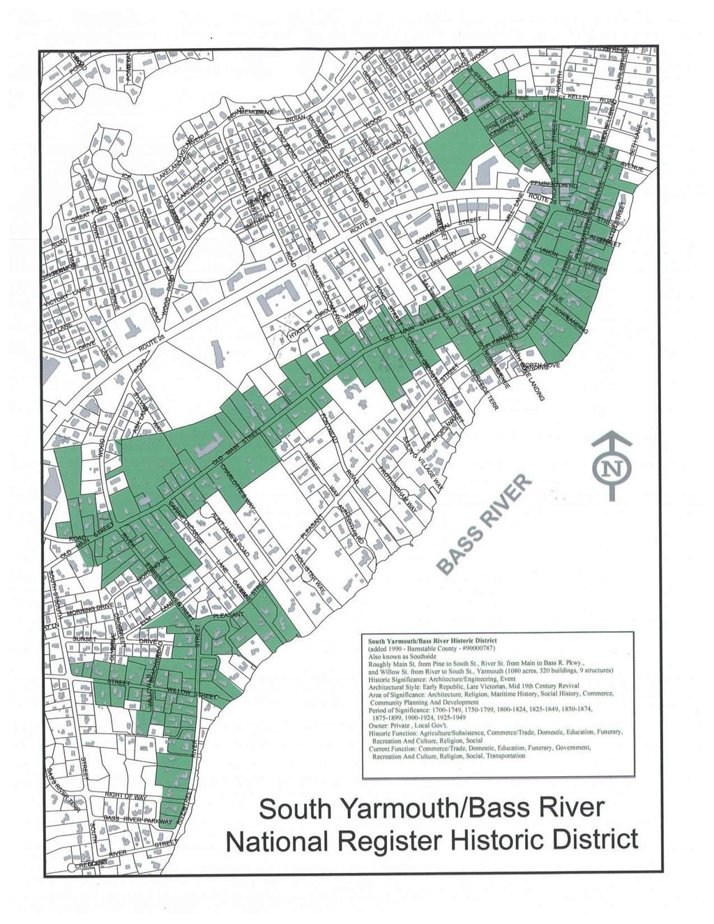
6 Road Safety Audit Main Street (Route 28) at North Main Street and Old Main Street, Yarmouth Prepared by Nitsch Engineering Task #2 FINAL The Town of Yarmouth provided additional background information, including a concept plan for the study intersection with proposed improvements from 1995, and a map of the South Yarmouth/Bass River National Register Historic District, which includes the study intersection. Both documents are included in Appendix D. On Friday, December 2, 2016, Nitsch Engineering conducted the RSA for the intersection of Main Street (Route 28) at North Main Street and Old Main Street in Yarmouth, MA The RSA occurred during dry and sunny conditions. As indicated in Table 1, the audit team consisted of representatives from MassDOT, the Town of Yarmouth, and Cape Cod Commission. The group observed operations with respect to safety at the study intersection and this report documents the audit team s findings. The RSA agenda can be found in Appendix A. Contact information for the team members can be found in Appendix B. Table 1: Participating Audit Team Members Audit Team Member Agency/Affiliation Jeff Bandini Jane Davis Elsa Chan Chris Falcos Kush Bhagat Barbara Lachance Bianca Marshall Tom Currier Jeff Colby Rick demello Nicholas Aguiar Kathy Williams Steven Tupper Chloe Schaefer Nitsch Engineering Nitsch Engineering MassDOT Traffic Safety MassDOT Traffic Safety MassDOT Traffic Safety MassDOT District 5 Traffic Operations MassDOT District 5 Traffic Operations MassDOT Project Management Boston Town of Yarmouth Yarmouth DPW Yarmouth DPW Yarmouth Town Planner Cape Cod Commission Cape Cod Commission Community Design Planner Page 2
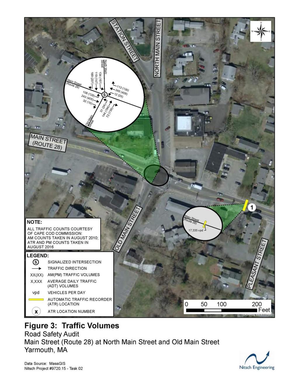
7 Road Safety Audit Main Street (Route 28) at North Main Street and Old Main Street, Yarmouth Prepared by Nitsch Engineering Task #2 FINAL Project Location and Description The Locus Map of the study area is shown in Figure 1. An aerial map of the study intersection of Main Street (Route 28) at North Main Street and Old Main Street is shown in Figure 2. Main Street (Route 28) at North Main Street and Old Main Street Main Street (Route 28) in Yarmouth is classified as an urban principal arterial that runs in the east-west directions through the project area. Massachusetts Route 28 overall, however, is designated as a north-south route, with its southern terminus in Eastham and its northern terminus in Methuen at the New Hampshire state line, where it continues as New Hampshire Route 28. The roadway is maintained by MassDOT and serves approximately 17,000 vehicles per day east of the project intersection. The speed limit along Main Street (Route 28) through the intersection is 30 miles per hour (mph). North Main Street in Yarmouth runs in the north-south directions through the project area. North Main Street is classified as an urban principal arterial through the intersection, and as an urban minor arterial north of Station Avenue, approximately 250 north of the intersection. The roadway is present from its southern terminus at the project intersection for approximately two miles to its northern terminus, just north of U.S. Route 6 where it continues as North Dennis Road. The speed limit along North Main Street is 30 mph through the intersection and 25 mph north of Station Avenue. The roadway is maintained by the Town of Yarmouth. Old Main Street in Yarmouth is classified as an urban minor arterial that runs in a general northeastsouthwest direction. Old Main Street is approximately one mile long with both termini intersecting Main Street (Route 28). The roadway is maintained by the Town of Yarmouth. The speed limit along Old Main Street is 30 mph through the intersection. The study intersection is controlled by a fully-actuated, uncoordinated traffic signal, however audit participants noted that the existing traffic loops used for vehicle detection may not be functional and the traffic signal controller may be defaulting to maximum recall for each phase. During summer months, the intersection experiences an increase in traffic when compared to the remainder of the year, as Yarmouth is a popular location for vacationers due to the presence of several beaches and tourist destinations. As such, the increase in traffic volumes during summer months exacerbates many of the issues outlined in this report. The study intersection is primarily located within the South Yarmouth/Bass River National Register Historic District. Thus, available right-of-way for potential safety improvements may be limited due to the proximity of the buildings located on the northeast and southwest corners to the abutting roadways and the intersection. North Main Street at Station Avenue Though the intersection of North Main Street and Station Avenue was not originally included in the scope of this RSA, due to its proximity to the study intersection and the angle at which Station Avenue intersects North Main Street, audit participants noted that the traffic operations at this intersection may affect those at the study intersection, and should therefore be included as part of the RSA. Page 3
8 Road Safety Audit Main Street (Route 28) at North Main Street and Old Main Street, Yarmouth Prepared by Nitsch Engineering Task #2 FINAL Station Avenue in Yarmouth is classified as an urban principal arterial that runs in the northwest-southeast direction. The roadway intersects North Main Street on its west side approximately 250 feet north of the study intersection, and provides access to U.S. Route 6 approximately two miles northwest of the intersection with North Main Street. The speed limit along Station Avenue is 30 mph near the intersection. The roadway is maintained by the Town of Yarmouth. The intersection of North Main Street and Station Avenue is unsignalized, with North Main Street operating freely, and Station Avenue operating under YIELD control. Audit participants noted that the Station Avenue approach previously operated under STOP control, and the control was modified to YIELD conditions roughly ten years ago. Page 4

9 Road Safety Audit Main Street (Route 28) at North Main Street and Old Main Street, Yarmouth Prepared by Nitsch Engineering Task #2 FINAL Figure 1: Locus Map Page 5

10 Road Safety Audit Main Street (Route 28) at North Main Street and Old Main Street, Yarmouth Prepared by Nitsch Engineering Task #2 FINAL Figure 2: Study Intersection Page 6
11 Road Safety Audit Main Street (Route 28) at North Main Street and Old Main Street, Yarmouth Prepared by Nitsch Engineering Task #2 FINAL Audit Observations and Potential Safety Enhancements Main Street (Route 28) at North Main Street and Old Main Street Traffic Operations Observation: The existing traffic signal system is outdated with respect to current MUTCD3 standards with respect to mast arm location and type, traffic signal indications, lack of signal backplates, vehicle detection, and lack of emergency preemption. Enhancement: Install a new traffic signal system that conforms to current MUTCD standards and respects the historical context of the intersection and the nearby historic resources, including but not limited to: steel mast arms, new signal indications with retroreflective backplates, new vehicle detection, and emergency vehicle preemption. Observation: Audit participants noted the existing traffic loops used for vehicle detection may not be functional, and the traffic signal controller may be defaulting to maximum recall for each phase. Enhancement: Investigate the functionality of the existing traffic signal loops used for vehicle detection, and repair if not functioning properly. Observation: The intersection clearance ( yellow plus all-red time) for each of the four approaches may not be adequate given the observed 85 th percentile travel speed, and may be a contributing factor to angle crashes 4, 7, 11, 14, 16, 21, 22, 32 and rear-end crashes 8, 9, 20, 24, 25, 28. Additionally, vehicles passing through the intersection after the signal has turned red (red-light running) may also be a contributing factor to angle crashes 4, 16, 21, and 32. Enhancement: Evaluate the clearance intervals and re-time the signals appropriately. Observation: The Main Street (Route 28) eastbound and westbound approaches each have exclusive left-turn lanes but no protected left-turn phase. The lack of exclusive left-turn phase may have contributed to angle crashes 7, 11, 14 and 22. Crashes 12 and 17 at the Main Street (Route 28) eastbound approach, which are rear-end crashes involving vehicles backing up, may also have been due to the lack of a left-turn phase. Audit participants noted that vehicles enter the intersection while waiting to turn left against oncoming traffic, and those that are unable to execute the turn before the northbound/southbound phase begins, back up into traffic so they do not impede the path of southbound vehicles through the intersection. Enhancement: Investigate if exclusive left-turn phases are warranted at Main Street (Route 28) eastbound and westbound to reduce the number of collisions that result from left-turning vehicles. If warranted, modify the phasing to include a protected 3 Manual on Uniform Traffic Control Devices (MUTCD), 2009 Edition Page 7
12 Road Safety Audit Main Street (Route 28) at North Main Street and Old Main Street, Yarmouth Prepared by Nitsch Engineering Task #2 FINAL and/or protected-permissive phase, and install new signals with Flashing Yellow Arrow (FYA) indications. Observation: The exclusive left-turn lanes at the Main Street (Route 28) eastbound and westbound approaches, and the North Main Street southbound approach each provide only approximately 100 feet of vehicle storage. Audit participants noted the storage is insufficient and vehicles frequently block the adjacent shared through/right-turn lanes at each approach. Enhancement: Determine the feasibility of extending the existing left-turn lanes to increase vehicle storage. Observation: The tight North Main Street southbound right-turn movement may be difficult to navigate given the radius of the northwest corner, which may be the cause of crash 26. Audit participants noted that heavy vehicles may be using Long Pond Drive as an alternate route to avoid this movement. Enhancement: Re-evaluate the radius between North Main Street southbound and Main Street (Route 28) westbound, and if appropriate, reconstruct the northwest corner to further accommodate turning movements. Representatives from the Town of Yarmouth indicated that the property on the northwest corner of the intersection is owned by the Town, which may streamline the design process. Signage Observation: There is no R3-7 Left Lane Must Turn Left signage in advance of the intersection nor at the stop line for the Main Street (Route 28) eastbound and North Main Street southbound approaches. Enhancement: Install R3-7 Left Lane Must Turn Left signage in advance of and at the intersection along the Main Street (Route 28) eastbound and North Main Street southbound approaches to limit vehicle lane changes close to the intersection. Observation: The guide signs for the Old Main Street northbound approach, which are located on the northeast corner, are angled improperly such that they are visible to the Main Street (Route 28) westbound approach and may lead to confusion. Enhancement: Rotate the existing guide signs on the northeast corner such that they are only visible from the Old Main Street northbound approach. Page 8
 westbound is the only approach that")
13 Road Safety Audit Main Street (Route 28) at North Main Street and Old Main Street, Yarmouth Prepared by Nitsch Engineering Task #2 FINAL Looking west, the guide signs on the northeast corner for northbound traffic are visible to westbound traffic Observation: Main Street (Route 28) westbound is the only approach that does not contain an R10-11b4 No Turn on Red (NTOR) designation, which may be warranted based on lack of available sight distance looking left. Furthermore, the NTOR designation does not appear to be observed from the other approaches, and may be the cause of crash 18. Enhancement: Investigate if a NTOR designation is warranted for Main Street (Route 28) westbound and, if warranted, install an R10-11b4 No Turn on Red sign. If appropriate, relocate the existing No Turn on Red signage for the other approaches in accordance with the MUTCD for improved visibility. Visibility Observation: The signal indications are of incandescent-type, and may lack the appropriate quantity of illumination for proper observation. Furthermore, there are no backplates which may make it difficult to identify the signal indication when the sun is low on the horizon, particularly the Main Street (Route 28) approaches. Enhancement: Install new signal indications with retroreflective backplates, which may require new signal heads and mast arms. 4 Ibid Page 9


14 Road Safety Audit Main Street (Route 28) at North Main Street and Old Main Street, Yarmouth Prepared by Nitsch Engineering Task #2 FINAL Aluminum mast arms, with incandescent signals and no backplates Observation: The 5-section doghouse signal indicating the protected-permissive phase for North Main Street southbound left-turns is located on the mast on the southeast corner of the intersection, as opposed to the typical location on the overhead mast arm, which may be difficult to observe for vehicles advancing within the queue. Enhancement: Replace the 5-section doghouse signal with a 4-section signal including FYA indication. The new signal would require installation of a new mast arm, and should be located overhead to increase visibility for vehicles advancing within the queue. Looking south, the doghouse signal located on the southeast corner of the intersection may be difficult to observe Page 10


15 Road Safety Audit Main Street (Route 28) at North Main Street and Old Main Street, Yarmouth Prepared by Nitsch Engineering Task #2 FINAL Observation: The rightmost signal for the Old Main Street northbound approach is blocked by vegetation, which may have contributed to crash 25. The rightmost signal for the North Main Street southbound approach is blocked by the adjacent building and vegetation, which could have contributed to crash 28. Enhancement: Trim vegetation at the Old Main Street northbound and North Main Street southbound approaches to improve visibility of signals and signage. Looking north, the rightmost signal cannot be observed due to vegetation Looking south, the rightmost signal cannot be observed due to the adjacent building and vegetation Access Management Observation: Angled parking is present on the east side of North Main Street just north of the intersection, and vehicles turning from Main Street (Route 28) onto North Main Street may not have adequate stopping sight distance to stop for vehicles backing onto North Main Street from an angled parking space. The presence of the parking lane in proximity to the intersection may have contributed to crash 5. Additionally, no shoulder line is present adjacent to the angled parking, which may give the impression of two travel lanes in the absence of any parked vehicles. Audit participants commented that the angled spaces are relatively short, such that the rear of a parked vehicle either extends into the traveled way or drivers pull the vehicle forward onto the sidewalk to fit the vehicle within the parking space. Audit participants also noted that there is an additional parking in the rear of the existing building, however, businesses rely heavily on the presence of the angled parking spaces in the front of the stores. Enhancement: In conjunction with the business owners along North Main Street, investigate the parking options for patrons and consider removing some of the angled parking spaces along North Main Street and/or converting to a parallel parking lane to increase sight distance from the intersection. Based on what is determined, consider adding a shoulder line. Page 11

16 Road Safety Audit Main Street (Route 28) at North Main Street and Old Main Street, Yarmouth Prepared by Nitsch Engineering Task #2 FINAL Beginning of angled parking lane Looking north, the angled parking lane on North Main Street may be too close to the intersection for adequate stopping sight distance Observation: The existing gas station curb cut on the east side of Old Main Street just south of the intersection may not have adequate sight lines due to the presence of vegetation, which is most likely the cause of angle crash 1. Drivers along Old Main Street may have to stop or slow down to allow vehicles to exit the driveway, which may have contributed to rear-end crash 15. Enhancement: Investigate if the permitted movements of the existing gas station driveway on Old Main Street can be modified to be right-in/right-out only to reduce the number of collisions that result from vehicles turning left into and out of the driveway. If permitted, install R3-25 No Left Turn and R6-15 One-Way signage and furnish new pavement markings. Observation: The curb cut for the municipal parking lot on the south side of Main Street (Route 28), just east of Mill Lane and adjacent to the Olympia Fish House, is approximately 130 feet long. This excessive opening allows patrons to turn into and out of the parking lot onto Main Street (Route 28) at any location along the curb cut frontage, which creates many vehicle conflict points and may lead to vehicles jockeying for positioning during high volume times. This could potentially be the cause of angle crashes 6 and 10, where vehicles exiting the property collided with eastbound vehicles along Main Street (Route 28). 5 Ibid Page 12
 as far")
17 Road Safety Audit Main Street (Route 28) at North Main Street and Old Main Street, Yarmouth Prepared by Nitsch Engineering Task #2 FINAL Enhancement: Reduce the width of the curb cut for the municipal parking lot adjacent to the Olympia Fish House and consider locating the curb cut on Main Street (Route 28) as far from the intersection as possible to reduce vehicle conflicts proximate to the intersection. Looking east, the municipal parking lot curb cut on Main Street (Route 28) may be too long, creating many vehicle conflict points, and may lead to vehicles jockeying during high volume times (Source: Google) Pedestrian Accommodations While there are no documented pedestrian crashes, we found the following safety issues and recommend the subsequent enhancements to improve conditions for pedestrians, especially those with limited mobility: Observation: The pedestrian signals are outdated, with scripted Walk and Don t Walk indications, no countdown display, faded and obsolete signage, and small push buttons, which may require applying excessive pressure. Furthermore, many of the existing pedestrian displays were not functional, and the pedestrian display on the southwest corner was turned to an angle that made it difficult to observe while waiting to cross from both the northwest and southeast corners. Enhancement: Investigate if the non-functioning pedestrian signal displays can be repaired, and if so, repair for the short-term until they can be replaced with new signals. Enhancement: Rotate the signal head on the southwest corner to face the crosswalks such that they can be seen from the northwest and southeast corners. Enhancement: Install a new pedestrian signal system compliant with current standards, including but not limited to signal displays with countdown, tactile push buttons, and Accessible Pedestrian Signals (APS). Page 13


18 Road Safety Audit Main Street (Route 28) at North Main Street and Old Main Street, Yarmouth Prepared by Nitsch Engineering Task #2 FINAL Pedestrian signal indications are scripted and not functional; push buttons are non-standard Pedestrian signal head on the southwest corner is angled and difficult to see from the crosswalk terminus Observation: Audit participants noted that the pedestrian Walk, flashing Don t Walk, and steady Don t Walk times may be inadequate. Enhancement: Evaluate the pedestrian walk and clearance time, and re-time the signals in compliance with the MUTCD if necessary. Page 14


19 Road Safety Audit Main Street (Route 28) at North Main Street and Old Main Street, Yarmouth Prepared by Nitsch Engineering Task #2 FINAL Observation: There are several issues with the existing pedestrian ramps and adjacent sidewalks: Each corner of the intersection contains one apex pedestrian ramp, rather than two perpendicular ramps, which is undesirable due to the relatively long crossing distance and can be confusing for the visually-impaired. Visually-impaired pedestrians rely on the position and angle of the detectable warning panel to access the adjacent crosswalk, and in the case of an apex ramp, pedestrians could be improperly guided directly into the middle of the intersection. The existing pedestrian ramps and sidewalks, particularly on the southeast corner, contain various obstructions that impede the movement of pedestrians and are therefore not compliant with Americans with Disabilities Act (ADA) and Massachusetts Architectural Access Board (MAAB) guidelines. Without having an existing layout plan available during the RSA, audit participants speculated this could be problematic for future intersection improvements based on the current sidewalk limits, and may require additional Right of Way (R.O.W.) takings. The signal mast on the southeast corner does not provide adequate horizontal clearance for pedestrians; the apex ramp at the corner is undesirable There is no curbing along the north side of Main Street (Route 28), which provides no grade separation to protect pedestrians from vehicles. There are two additional pedestrian ramps located on the southeast corner of the intersection offset from the apex ramp, one on the south side of Main Street (Route 28) just east of the intersection, and one on the east side Looking west, there is no curbing on the north side of Main Street (Route 28), which leaves little protection for pedestrians (Source: Google) Page 15


 just west of the intersection, which could be a tripping")
20 Road Safety Audit Main Street (Route 28) at North Main Street and Old Main Street, Yarmouth Prepared by Nitsch Engineering Task #2 FINAL of Old Main Street just south of the intersection. The presence of these additional ramps may cause confusion to pedestrians as they are not located at a crosswalk and could improperly lead pedestrians into the traveled way. The two additional pedestrian ramps on the southeast corner, one on the east side of Old Main Street (left) and one on the south side of Route 28 (right), are not located at a crosswalk and could cause confusion Enhancement: Re-evaluate the necessity of the apex pedestrian ramps, remove or relocate the additional pedestrian ramps on the southeast corner, and reconfigure the ramp layout and adjacent sidewalks as necessary in compliance with current ADA and MAAB standards, including but not limited to, removal of obstructions, adequate horizontal clearance, and grade separation. Observation: Audit participants noted an approximately 3 high breakaway sign post obstruction on the north side of Main Street (Route 28) just west of the intersection, which could be a tripping hazard. Enhancement: Remove the sign post tripping hazard. The sign post on the northwest corner of the intersection poses a tripping hazard; The signal mast does not provide adequate horizontal clearance for pedestrians Page 16

21 Road Safety Audit Main Street (Route 28) at North Main Street and Old Main Street, Yarmouth Prepared by Nitsch Engineering Task #2 FINAL Observation: There is existing signage on the northwest and southwest corners of the intersection directing travelers towards the beach. These signs are not compliant with the MUTCD, and are mounted low and do not provide adequate vertical clearance for pedestrians. Enhancement: Replace the existing directional beach signage with signage compliant with the MUTCD, and install with appropriate vertical clearance. Bicycle Accommodations The existing signage pointing towards the beach poses a vertical clearance issue While there are no documented bicycle crashes, we found the following safety issue and recommend the subsequent enhancement to improve conditions for bicycles: Observation: There are no bicycle accommodations present along Main Street (Route 28), North Main Street, or Old Main Street. The Town of Yarmouth has indicated it has plans to increase the desirability of bicycling within the study area. Bus Accommodations Enhancement: Install bicycle accommodations by providing exclusive or separated bicycle lanes where possible. Observation: There are existing Cape Cod Regional Transit Authority (CCRTA) bus stops located on Main Street (Route 28) eastbound and westbound just west of the intersection, however, there are no turnouts present in either direction, with little room for a bus to pull out of the traveled way. This can reduce the traffic flow and could contribute to collisions of vehicles attempting to circumvent the bus. Enhancement: Determine the feasibility of providing bus turnouts near the CCRTA bus stops. Page 17
22 Road Safety Audit Main Street (Route 28) at North Main Street and Old Main Street, Yarmouth Prepared by Nitsch Engineering Task #2 FINAL Lighting Observation: Audit participants noted that lighting is only present on the northwest and southeast corners of the intersection, which may not be adequate at night, particularly for pedestrians. Enhancement: Install additional lighting at the intersection. Drainage Observation: Audit participants noted the proximity of the intersection to Bass River and its Nitrogen-impaired Bass River Watershed, and potential issues with drainage can increase the likelihood of vehicle crashes. Enhancement: Any intersection improvements should adequately incorporate drainage, stormwater management, and stormwater treatment into the design to reduce the likelihood of crashes, taking into consideration the impaired Bass River Watershed. North Main Street at Station Avenue Traffic Operations Observation: The YIELD control on Station Avenue eastbound may be unexpected, as STOP control may be more typical for an intersection of this type, which may be the cause of crashes 2 and 30. Audit participants noted that the Station Avenue approach was previously under STOP control, and control was modified to YIELD roughly ten years ago. Furthermore, the angle at which Station Avenue meets North Main Street coupled with the YIELD control may also be confusing for Station Avenue eastbound left-turning vehicles, and is likely the cause of crash 29. Audit participants speculated that Station Avenue contained the larger volume of vehicles at this intersection, and questioned if Station Avenue eastbound should operate as the free movement and North Main Street southbound should operate under STOP control. Cape Cod Commission confirmed this speculation in a post-rsa correspondence, indicating that per past traffic volume studies, Station Avenue serves approximately 6,000 vehicles per day, while North Main Street serves approximately 3,000 vehicles per day. Enhancement: Re-evaluate the existing YIELD control at the Station Avenue eastbound approach, and determine if the traffic control at the intersection should be modified. Enhancement: Evaluate the geometry at the intersection, and based on the control determination, consider realigning Station Avenue to intersect North Main Street at as close to a 90-degree angle as possible, or installing a roundabout or a mini-roundabout, if feasible. Page 18

23 Road Safety Audit Main Street (Route 28) at North Main Street and Old Main Street, Yarmouth Prepared by Nitsch Engineering Task #2 FINAL Signage Observation: There is no advanced warning signage along Station Avenue approaching the intersection with North Main Street, and due to the both the geometry and YIELD control, the intersection may be unexpected. Enhancement: Provide adequate advanced warning of the intersection, regardless of the control determination. Observation: Traveling north on North Main Street to Station Avenue, the wayfinding signage to U.S. Route 6 is not compliant with the MUTCD and may be difficult to observe due to its size and placement. Enhancement: Replace the existing wayfinding signage to U.S. Route 6 at the intersection of North Main Street and Station Avenue with standard guide signs in conformance with the MUTCD. The wayfinding signage at the corner of North Main Street and Station Avenue is not standard and may be difficult to observe Visibility Observation: The existing YIELD sign on Station Avenue is rotated slightly away from the roadway and may be blocked by vegetation during summer months. Enhancement: Rotate the existing YIELD sign towards the roadway at the Station Avenue approach. Enhancement: Clear any vegetation that potentially blocks the YIELD sign at the Station Avenue approach. Page 19

24 Road Safety Audit Main Street (Route 28) at North Main Street and Old Main Street, Yarmouth Prepared by Nitsch Engineering Task #2 FINAL The YIELD sign for Station Avenue is rotated away from the roadway and may be blocked by vegetation during summer months Access Management Observation: Pemberton Road is a local road that runs parallel to and located approximately 175 north of Main Street (Route 28) and 75 feet south of North Main Street at Station Avenue. Audit participants noted that Pemberton Road provides access to off-street parking and is frequently used as a cut-through to avoid backups at the study intersection. Due to the relatively narrow width of Pemberton Road, the roadway resembles a driveway or alley, and the number of vehicles turning in and out of the roadway may be unexpected. This may be problematic due to its proximity to both intersections, particularly for vehicles yielding and likely looking left from the Station Avenue approach who may not have adequate time to stop for vehicles turning in or out of Pemberton Road. This access management issue may have been a contributing factor in crash 33. Enhancement: Install W2-26 (Horizontal Alignment/Intersection Sign Side Road) signage with supplemental W16-8P6 Pemberton Road plaque to provide warning of Pemberton Road for vehicles traveling along North Main Street southbound and Station Avenue eastbound. 6 Ibid Page 20

25 Road Safety Audit Main Street (Route 28) at North Main Street and Old Main Street, Yarmouth Prepared by Nitsch Engineering Task #2 FINAL Looking north, Pemberton Road is proximate to both the project intersection and Station Avenue, and vehicles yielding from Station Avenue may not have adequate stopping sight distance (Source: Google) Pedestrian Accommodations Observation: There is little pedestrian connectivity at the intersection of North Main Street and Station Avenue, particularly across North Main Street, which may have been the cause of crash 31. Bicycle Accommodations Enhancement: Based on the control determination at the intersection of North Main Street and Station Avenue, investigate providing pedestrian connectivity, including the installation of additional sidewalk, pedestrian ramps, and/or the installation of crosswalks at the intersection. Observation: There are no bicycle accommodations present along Station Avenue. The Town of Yarmouth has indicated it has plans to increase the desirability of bicycling within the study area. Enhancement: Install bicycle accommodations by providing exclusive or separated bicycle lanes where possible. Page 21
26 Road Safety Audit Main Street (Route 28) at North Main Street and Old Main Street, Yarmouth Prepared by Nitsch Engineering Task #2 FINAL Summary of Road Safety Audit Nitsch Engineering has been retained by MassDOT to complete an RSA for the intersection of Main Street (Route 28) at North Main Street and Old Main Street in Yarmouth, MA. We incorporated the intersection of North Main Street and Station Avenue to the scope of this RSA due to its proximity and its effect of the traffic operations at the study intersection. We tabulated the safety issues and potential safety enhancements discussed during the RSA, with the associated potential safety payoff, the estimated time frame for completion, the estimated construction cost, and the responsible agency. Table 2 shows the breakdown of the estimated time frame and cost. Safety payoff estimates are subjective and are based on engineering judgment and the perceived likelihood that the proposed safety enhancement will reduce the quantity and severity of future crashes. Table 2: Estimated Time Frame and Costs Breakdown Time Frame Costs Short-Term <1 Year Low <$10,000 Mid-Term 1-3 Years Medium $10,001-$50,000 Long-Term >3 Years High >$50,000 Table 3 summarizes the intersection of Main Street (Route 28) at North Main Street and Old Main Street and Table 4 summarizes the intersection of North Main Street at Station Avenue. Page 22
27 Road Safety Audit Main Street (Route 28) at North Main Street and Old Main Street, Yarmouth Prepared by Nitsch Engineering Task #2 FINAL Table 3: Potential Safety Enhancement Summary Main St. at North Main St. and Old Main St. Safety Issue Traffic Operations Signage Visibility Access Management Potential Safety Enhancement Install a new traffic signal system including mast arms, signal indications with retroreflective backplates, vehicle detection, and emergency vehicle preemption Safety Payoff Time Frame Cost Responsible Agency High Long-term High MassDOT Repair existing traffic signal loops Low Short-term Low MassDOT Evaluate the clearance interval and re-time if necessary High Short-term Low MassDOT Modify the phasing to include a protected and/or protectedpermissive phase, and install new signals with FYA indications on Main Street (Route 28) If feasible, extend the existing left-turn lanes to increase vehicle storage Reconstruct the northwest corner to further accommodate turning movements Install R3-7 Left Lane Must Turn Left signage in advance of the intersection along the Main Street (Route 28) and North Main Street southbound approaches Rotate guide signs on northeast corner for the Old Main Street northbound approach If warranted, install an R10-11b No Turn on Red sign at the Main Street (Route 28) westbound approach and relocate the existing No Turn on Red signage for the other approaches Install new signal indications with retroflective backplates, which may require new signal heads and mast arms Remove the 5-section doghouse signal and install a 4-section signal including FYA located overhead, which would require a new mast arm Trim vegetation at the Old Main Street northbound and North Main Street southbound approaches If appropriate, remove some of the angled parking spaces along North Main Street and/or convert to a parallel parking lane, and add a shoulder line High Long-term High MassDOT Medium Mid-term High Medium Mid-term Medium Medium Short-term Low MassDOT/Town of Yarmouth MassDOT/Town of Yarmouth MassDOT/Town of Yarmouth Low Short-term Low MassDOT Medium Short-term Low MassDOT High Long-term High MassDOT High Long-term High MassDOT High Short-term Low Medium Short-term Low MassDOT/Town of Yarmouth Town of Yarmouth Page 23
28 Road Safety Audit Main Street (Route 28) at North Main Street and Old Main Street, Yarmouth Prepared by Nitsch Engineering Task #2 FINAL Safety Issue Access Management (continued) Pedestrian Accommodations Table 3 (continued): Potential Safety Enhancement Summary Main St. at North Main St. and Old Main St. Potential Safety Enhancement If appropriate, modify the permitted movements of the existing gas station driveway on Old Main Street to be right-in/right-out only, install R3-2 No Left Turn and R6-1 One-Way signage and furnish new pavement markings Reduce the width of the curb cut for the municipal parking lot adjacent to Olympia Fish House on Main Street (Route 28) Safety Payoff Time Frame Medium Short-term Cost Low Medium Mid-term Medium Responsible Agency Town of Yarmouth MassDOT/Town of Yarmouth Repair non-functioning pedestrian signal displays Medium Short-term Low MassDOT Rotate the signal head on the southwest corner to face the crosswalks Install a new pedestrian signal system compliant with current standards, including but not limited to, signal displays with countdown, tactile push buttons, and APS Re-time the pedestrian signals with MUTCD-compliant walk and clearance times Remove or relocate the additional pedestrian ramps on the southeast corner, and reconfigure the ramp layout and adjacent sidewalks in compliance with current ADA and MAAB standards, including but not limited to, removal of obstructions, adequate horizontal clearance, and grade separation. Medium Short-term Low MassDOT Medium Mid-term Medium MassDOT Medium Short-term Low MassDOT Medium Long-term High MassDOT Remove the sign post-tripping hazard on Main Street (Route 28) Low Short-term Low MassDOT Replace the existing directional beach signage with MUTCDcompliant signage at the appropriate vertical clearance Low Short-term Low MassDOT/Town of Yarmouth Bicycle Accommodations Install exclusive or separated bicycle lanes Medium Short-term Low MassDOT/Town of Yarmouth Bus Accommodations If feasible, provide bus turnouts near the CCRTA bus stops Medium Mid-term Medium MassDOT Lighting Install additional lighting at the intersection Medium Mid-term Medium MassDOT Drainage Incorporate drainage improvements Medium Long-term High MassDOT Page 24
29 Road Safety Audit Main Street (Route 28) at North Main Street and Old Main Street, Yarmouth Prepared by Nitsch Engineering Task #2 FINAL Safety Issue Traffic Operations Signage Visibility Access Management Pedestrian Accommodations Table 4: Potential Safety Enhancement Summary North Main St. at Station Ave. Potential Safety Enhancement Evaluate the existing Station Avenue YIELD control, and if necessary, modify the traffic control at intersection If appropriate, re-align Station Avenue to intersect North Main Street at as close to a 90-degree angle as possible or install roundabout or mini-roundabout Safety Payoff High Time Frame Cost Short-term Medium High Long-term High Provide advanced warning of the intersection Medium Short-term Low Replace wayfinding signage to U.S. Route 6 MUTCD-compliant signage Rotate existing YIELD sign towards the roadway at the Station Avenue approach Clear any vegetation that blocks the existing YIELD sign at the Station Avenue approach Install W2-2 (Horizontal Alignment/Intersection Sign Side Road) signage with supplemental W16-8P Pemberton Road plaque Investigate providing pedestrian connectivity, and if appropriate, install sidewalk, pedestrian ramps, and/or crosswalks at the intersection Low Short-term Low Medium Short-term Medium Short-term Medium Short-term Low Low Low Medium Mid-term High Responsible Agency Town of Yarmouth Town of Yarmouth Town of Yarmouth Town of Yarmouth Town of Yarmouth Town of Yarmouth Town of Yarmouth Town of Yarmouth Bicycle Accommodations If feasible, install exclusive or separated bicycle lanes Medium Short-term Low Town of Yarmouth Page 25
30 Appendix A. RSA Meeting Agenda
31 Road Safety Audit Yarmouth, MA Main Street (Route 28) at North Main Street and Old Main Street Meeting Location: South Yarmouth Library 312 Old Main Street, South Yarmouth, MA Friday, December 2, :30 AM 1:00 PM Type of meeting: Attendees: Please bring: High Crash Location Road Safety Audit Invited Participants to Comprise a Multidisciplinary Team Thoughts and Enthusiasm!! 10:30 AM Welcome and Introductions 10:45 AM Discussion of Safety Issues 11:15 AM Site Visit Crash history, Speed Regulations provided in advance Existing Geometries and Conditions Walk to the intersection of Main St (Rte 28), North Main St, and Old Main St As a group, identify areas for improvement 12:15 PM Discussion of Potential Improvements Discuss observations and finalize safety issue areas Discuss potential improvements and finalize recommendations 1:00 PM Adjourn for the Day but the RSA has not ended Instructions for Participants: Before attending the RSA on December 2 nd, participants are encouraged to drive/walk through the intersection and complete/consider elements on the RSA Prompt List with a focus on safety. All participants will be actively involved in the process throughout. Participants are encouraged to come with thoughts and ideas, but are reminded that the synergy that develops and respect for others opinions are key elements to the success of the overall RSA process. After the RSA meeting, participants will be asked to comment and respond to the document materials to assure it is reflective of the RSA completed by the multidisciplinary team.
32 Appendix B. RSA Audit Team Contact List
33 Participating Audit Team Members Date: December 2, 2016 Location: Yarmouth, MA Audit Team Members Agency/Affiliation Address Phone Number Jeff Bandini Nitsch Engineering Jane Davis Nitsch Engineering Elsa Chan MassDOT Traffic Safety Chris Falcos MassDOT Traffic Safety -- Kush Bhagat MassDOT Traffic Safety Barbara Lachance Bianca Marshall Tom Currier MassDOT District 5 Traffic Operations MassDOT District 5 Traffic Operations MassDOT Project Management Boston barbara.lachance@dot.state.ma.us bianca.marshall@dot.state.ma.us thomas.currier@dot.state.ma.us Jeff Colby Town of Yarmouth jcolby@yarmouth.ma.us Rick demello Yarmouth DPW rdemello@yarmouth.ma.us Nicholas Aguiar Yarmouth DPW naguiar@yarmouth.ma.us Kathy Williams Yarmouth Town Planner kwilliams@yarmouth.ma.us Ext Ext Steven Tupper Cape Cod Commission stupper@capecodcommission.org Chloe Schaefer Cape Cod Commission Community Design Planner chloe.schaefer@capecodcommision.org
34 Appendix C. Detailed Crash Data
35
36 Crash Diagram Crash Weather Ref # Date m/d/y Crash Day Time of Day Manner of Collision Type Light Condition Type Dark - lighted Condition Type 1 1/14/12 Saturday 7:32 PM Angle roadway Clear Crash Data Summary Table Route 28 (Main Old Main St, Yarmouth, MA Road Surface Type Driver Contributing Code Type Dry Inattention /25/12 Wednesday 4:26 PM Rear-end Daylight Clear Dry Inattention /18/12 Saturday 8:42 AM Sideswipe, opposite direction Daylight Clear Dry Inattention /24/12 Wednesday 8:09 AM Angle Daylight Clear Dry Inattention MV 1 was traveling EB on Route 28 ran red light MV 2 was traveling NB on N Main St and was struck by MV 1 which was 5 1/2/13 Wednesday 11:37 AM Angle Daylight Clear Dry Inattention attempting to merge into the travel lane from on street parking space 6 1/12/13 Saturday 3:33 PM Angle Daylight Cloudy Dry Failed to yield right of way /9/13 Saturday 2:07 PM Angle Daylight Clear Dry Failed to yield right of way /21/13 Friday 7:05 PM Rear-end Daylight Clear Dry Followed too closely Dark - lighted 9 6/22/13 Saturday 8:39 PM Rear-end roadway Clear Dry Unknown 21 UNK Hit and ran 10 7/11/13 Thursday 10:41 AM Angle Daylight Clear Dry Failed to yield right of way Courtesy Crash MV 1 was traveling SB on N Main St, changed lane from left turn lane to 11 7/25/13 Thursday 10:41 AM Angle Daylight Unknown Dry D1 Ages D2 Swerving or avoiding due to wind, slippery surface, vehicle, object, nonmotorist in roadway, etc Operating Vehicle in erratic, reckless, D3 D4 Comments through lane when entering the intersection and struck MV 2 which was turning left from Old Main St onto Route 28 and thought MV 1 was turning left in the first place 12 8/4/13 Sunday 3:40 PM Angle Daylight Clear Dry careless, negligent, or aggressive manner No narrative MV 2 was turning right and sideswiped by MV 1 which was attempting to 13 8/21/13 Wednesday 2:29 PM Sideswipe, same direction Daylight Unknown Dry Made an improper turn switch lane from through lane to left lane MV 2 was stopped at middle of intersection waiting to turn left from Old Main St onto Route 28 WB, MV 1 was traveling SB on N Main St and anticipated MV 2 would have turned by the time MV 2 arrives the intersection, however, 14 8/24/13 Saturday 10:51 AM Angle Daylight Clear Dry Failed to yield right of way MV 2 did not turn and MV 1 struck MV /27/13 Tuesday 11:09 AM Rear-end Daylight Clear Dry Followed too closely /2/13 Wednesday 7:24 PM Angle Dusk Clear Dry Inattention MV 1 was traveling on NB Old Main St ran red light Operating Vehicle in erratic, reckless, careless, negligent, or aggressive 17 10/13/13 Sunday 4:35 PM Rear-end Daylight Clear Dry manner MV 2 rear ended MV 1 and operator put MV 2 in reverse and crash into MV 3 Both operator claim they have the green light, unable to determine who was 18 2/16/14 Sunday 1:47 PM Angle Daylight Clear Wet Unknown at fault MV 1 was slowing down for traffic on WB Rt 28, MV 2 was turning left from Old Main St onto RT 28 WB, and was accelerating to avoid another vehicle 19 7/1/14 Tuesday 2:42 PM Rear-end Daylight Clear Dry Inattention traveling on RT 28 EB. After entering RT 28 WB, MV 2 rear ended MV /8/14 Tuesday 5:10 PM Rear-end Daylight Clear Dry Inattention /23/14 Wednesday 6:17 AM Angle Daylight Clear Dry Inattention MV 1 was traveling on RT 28 WB ran red light Dark - lighted 22 10/11/14 Saturday 8:33 PM Angle roadway Cloudy Wet Other improper action MV 2 did not yield the right of way when making the left turn 23 12/5/14 Friday 12:11 PM Sideswipe, same direction Daylight Clear Dry Swerving or avoiding due to wind, slippery surface, vehicle, object, nonmotorist in roadway, etc /2/15 Thursday 3:26 PM Rear-end Daylight Clear Dry Inattention Operating Vehicle in erratic, reckless, careless, negligent, or aggressive 25 4/8/15 Wednesday 7:54 AM Rear-end Daylight Clear Dry manner Operating Vehicle in erratic, reckless, 26 6/19/15 Friday 2:40 PM Single Vehicle Crash Daylight Clear Dry MV 2 was in the left turn lane, and was sideswiped by MV 1 which swerved into the left lane from the right lane to avoid a disabled vehicle MV 2 and MV 3 was stopped at the red light, MV 1 rear ended MV 2 and the impact caused MV 2 to hit MV 3 careless, negligent, or aggressive manner 34 The trailer of MV 1 struck traffic light pole while MV 1 was turning right 27 7/10/15 Friday 1:11 AM Single Vehicle Crash Dark - roadway not lighted Clear Dry Unknown MC 1 hit the curb when turning right from Route 28 onto Old Main St and lost control which also caused MC 2 lost control. Fatal damage on MC /22/15 Wednesday 8:22 AM Rear-end Daylight Clear Dry Unknown /1/15 Saturday 2:29 PM Angle Daylight Clear Dry Unknown No narrative MV 2 was yielding for another vehicle approaching from NB of N Main St, MV 30 8/8/15 Saturday 9:42 AM Rear-end Daylight Clear Dry Followed too closely did not react and rear ended MV 2
37 Crash Diagram Ref # Crash Date m/d/y Crash Day Time of Day Manner of Collision Type Light Condition Type Crash Data Summary Table Route 28 (Main Old Main St, Yarmouth, MA Weather Condition Type Road Surface Type Driver Contributing Code Type MV 1 was turning left from the driveway, pedestrian 1 was attempting to 31 8/12/15 Wednesday 12:15 PM Single Vehicle Crash Daylight Clear Dry Unknown cross N Main St at non-crosswalk location and was hit by MV 1 Operating Vehicle in erratic, reckless, careless, negligent, or aggressive 32 8/28/15 Friday 3:53 PM Angle Daylight Clear Dry manner MV 1 on N Main St SB ran red light Dark - lighted 33 11/6/15 Friday 2:51 AM Single Vehicle Crash roadway Rain Wet Inattention 56 D1 Ages D2 D3 D4 Comments *Courtesy Crash - A term used to describe a crash that occurs subsequent to a non-involved mainline driver who gives the right of way, contrary to the rules of the road, to another driver. Summary based on Crash Reports obtained from the Yarmouth Police Department.
38 30% 25% 20% 15% 10% 5% 0% Crash Data Summary Tables and Charts Route 28 (Main Old Main St, Yarmouth, MA CRASH MONTH 24% 27% 9% 9% 6% 3% 3% 0% 0% J F M A M J J A S 12% 3% 3% O N D CRASH DAY OF WEEK 30% 27% 27% 25% 20% 18% 15% 10% 9% 9% 9% 5% 0% 0% Monday Tuesday Wednesday Thursday Friday Saturday Sunday CRASH TIME OF DAY 30% 27% 25% 20% 15% 15% 12% 9% 9% 9% 10% 6% 5% 0% 6AM- 8AM 8AM- 10AM- 12PM- 2PM- 4PM 4PM- 6PM 6PM- 8PM 8PM- 10PM- 10AM 12PM 2PM 10PM 12AM 6% 0% 3% 3% 0% 12AM- 2AM- 4AM 4AM- 6AM 2AM 50% 45% 40% 35% 30% 25% 20% 15% 10% 5% 0% 12% 33% CRASH MANNER OF COLLISION 45% Single Rear-end Angle Sideswipe, Sideswipe, Head on Vehicle same opposite Crash direction direction 6% 3% 0% 0% 0% Rear to Rear Unknown
39 90% 82% 80% 70% 60% 50% 40% 30% 20% 10% 0% Daylight Crash Data Summary Tables and Charts Route 28 (Main Old Main St, Yarmouth, MA CRASH LIGHT CONDITION 12% 3% 3% 0% 0% 0% Dawn Dusk Dark - Dark - Dark - Other Lighted Roadway not unknown Roadway lighted roadway lighting 0% Unknown 90% 80% 70% 60% 50% 40% 30% 20% 10% 0% 85% Clear CRASH WEATHER CONDITION 6% 3% 0% 0% 0% 0% 0% 0% Cloudy Rain Snow Sleet, Hail, Fog, Smog, Severe Blowing Other Freezing Smoke Crosswinds sand, snow Rain 6% Unknown 100% 91% 90% 80% 70% 60% 50% 40% 30% 20% 10% 0% Dry CRASH ROAD SURFACE 9% 0% 0% 0% 0% 0% 0% Wet Snow Ice Sand, mud, Water Slush Other dirt, oil, (standing, gravel moving) 0% Unknown CRASH DRIVER AGES 25% 20% 20% 20% 17% 15% 10% 10% 13% 13% 5% 3% 3% 0%
40 INTERSECTION CRASH RATE WORKSHEET, CITY/TOWN : YARMOUTH COUNT DATE : Aug-16 DISTRICT : 5 UNSIGNALIZED : SIGNALIZED : X MAJOR STREET : MAIN STREET (ROUTE 28) ~ INTERSECTION DATA ~ MINOR STREET(S) : NORTH MAIN STREET OLD MAIN STREET INTERSECTION DIAGRAM (Label Approaches) North North Main St PEAK HOUR VOLUMES APPROACH : DIRECTION : SB WB NB EB PEAK HOURLY VOLUMES (AM/PM) : Total Peak Hourly Approach Volume ,989 INTERSECTION ADT ( V ) = TOTAL DAILY " K " FACTOR : ,414 APPROACH VOLUME : AVERAGE # OF # OF TOTAL # OF CRASHES : 33 4 CRASHES PER YEAR ( 8.25 YEARS : A ) : CRASH RATE CALCULATION : 0.80 RATE = ( A * 1,000,000 ) ( V * 365 ) Comments : PM PEAK USED Project Title & Date: MAIN STREET (ROUTE 28), ROAD SAFETY AUDIT, DECEMBER 2016
41 Appendix D. Additional Information
42
43
44
45
46
47
48
49
50
51
52
53
54
55
56
57
58
59
60
61
62
63
64
65
66
67
68
ROAD SAFETY AUDIT. Iyannough Road (Route 28) at Yarmouth Road. Town of Barnstable. September 2012
 at Yarmouth Road. Town of Barnstable. September 2012") ROAD SAFETY AUDIT Iyannough Road (Route 28) at Yarmouth Road Town of Barnstable September 2012 Prepared for: Massachusetts Department of Transportation Prepared by: Howard/Stein-Hudson Associates 38 Chauncy
ROAD SAFETY AUDIT Iyannough Road (Route 28) at Yarmouth Road Town of Barnstable September 2012 Prepared for: Massachusetts Department of Transportation Prepared by: Howard/Stein-Hudson Associates 38 Chauncy
4. Safety Concerns Potential Short and Medium-Term Improvements
 NH Route 104 Access Management Study Page 19 4. Safety Concerns Potential Short and Medium-Term Improvements Potential safety improvement strategies are listed by priority based on field observations by
Attachment No. 20 RRLRT No. 1. Committee. Busway Grade Crossings STATUS/DATE OF ACTION
 Attachment No. 20 RRLRT No. 1 TECHNICAL COMMITTEE: Railroad / Light Rail Transit Technical Committee TOPIC: Busway Grade Crossings STATUS/DATE OF ACTION RRLRT TC Draft: 06/23/2011 RRLRT TC Approval: 06/27/2014
TABLE OF CONTENTS. Coral Springs Charter High School and Middle School Job No Page 2
 Job No. 15-019 Page 2 TABLE OF CONTENTS 1.0 INTRODUCTION... 4 2.0 EXISTING CONDITIONS... 5 3.0 TRAFFIC GENERATION... 7 4.0 TRIP DISTRIBUTION... 8 5.0 FUTURE CONDITIONS... 8 6.0 SITE ACCESS...13 7.0 CONCLUSION...13
Pedestrian Safety Review Spadina Avenue
 STAFF REPORT ACTION REQUIRED Pedestrian Safety Review Spadina Avenue Date: October 13, 2015 To: Toronto and East York Community Council From: Director, Transportation Services, Toronto and East York District
FEASIBILITY STUDY REFINED CONCEPT 1 PROJECT A
 VIRGINIA DEPARTMENT OF TRANSPORTATION I-85 / I-95 INTERCHANGE FEASIBILITY STUDY REFINED CONCEPT 1 PROJECT A Columbia Rd REFINED CONCEPT 1 PROJECT A Bellevue Rd COST: $3.3M Siege Rd Eliminate the loop ramp
Queen s Circus Roundabout
 Stage 2 Road Safety Audit Ref: 1128-RSA-01 Prepared for: Steer Davies Gleave By: Capital Traffic Prepared by: Checked by: Approved by: Andy Haunton, Audit Team Leader Jonathan Thompson, Audit Team Member
Lake Erie Commerce Center Traffic Analysis
 LOCATION: East of NYS Route 5 at Bayview Road Town of Hamburg Erie County, New York PREPARED BY: Wendel Companies 140 John James Audubon Parkway Suite 200 Amherst, New York 14228 January 2012 i ii Table
TRAFFIC CONTROL DEVICES MANUAL FOR WORK ZONES
 TRAFFIC CONTROL DEVICES MANUAL FOR WORK ZONES SUMMARY Work zone activities often create conditions on the travelled way that are hazardous particularly at night when the ability of motorists to see is
EXISTING CONDITIONS A. INTRODUCTION. Route 107 Corridor Study Report
 II. EXISTING CONDITIONS A. INTRODUCTION The Route 107 study area extends from the south at Chestnut Street in Lynn approximately 3.7 miles to the north to Boston Street in Salem. The study area has three
MEMORANDUM. Bob Zagozda, Chief Financial Officer Westside Community Schools. Mark Meisinger, PE, PTOE Felsburg Holt & Ullevig. DATE: June 11, 2018
 MEMORANDUM TO: Bob Zagozda, Chief Financial Officer Westside Community Schools FROM: Mark Meisinger, PE, PTOE Felsburg Holt & Ullevig DATE: June 11, 218 6-11-18 SUBJECT: Sunset Hills Elementary School
November 21, 2012 Barbara Kelleher, (954)
") November 21, 2012 Barbara Kelleher, (954) 777-4090 barbara.kelleher@dot.state.fl.us BROWARD COUNTY TRAFFIC IMPACT REPORT November 26 to November 30, 2012 FORT LAUDERDALE -- Construction and maintenance-related
November 21, 2012 Barbara Kelleher, (954) 777-4090 barbara.kelleher@dot.state.fl.us BROWARD COUNTY TRAFFIC IMPACT REPORT November 26 to November 30, 2012 FORT LAUDERDALE -- Construction and maintenance-related
5.1 Traffic and Transportation
 5.1 When it opens in 2009, the Bellevue Nickel Improvement Project will increase the number of vehicles able to travel through the study area, improve travel speeds, and improve safety by reducing the
Site Location and Setting
 Memorandum Date: To: From: Subject: Kristy Le, Gary Black Steve Orem Santa Teresa County Park Historic Area Traffic and Parking Study Hexagon Transportation Consultants, Inc. has completed a traffic and
Non-Motorized Transportation
 Non-Motorized Transportation Non-motorized facilities are important components to the transportation system. They provide an environmentally-friendly, low-cost mode of travel. Some of the facilities can
Proposed Bicycle Lanes on Yonge Street from Queens Quay to Front Street
 STAFF REPORT ACTION REQUIRED Proposed Bicycle Lanes on Yonge Street from Queens Quay to Front Street Date: March 12, 2007 To: From: Toronto and East York Community Council Director, Transportation Infrastructure
London Borough of Barnet Traffic & Development Design Team
 London Borough of Barnet Traffic & Development Design Team AERODROME ROAD PEDESTRIAN FACILITY AND BUS STOP INTRODUCTION FEASIBILITY REPORT Job Number: 60668 Doc Ref: S106/12-13/60668 Author: Manoj Kalair
University Region Non-Motorized Plan 2015
 Non-Motorized Transportation Non-motorized facilities are important components to the transportation system. They provide an environmentally-friendly, low-cost mode of travel. Some of the facilities can
K SIGNAGE & TRAFFIC CONTROL. Table of Contents
 Table of Contents K1. ACCOMMODATION OF TRAFFIC... 1 K2. MINIMUM CONSTRUCTION SIGNING... 1 K3. SUBDIVISION SIGNS... 2 K4. TRAFFIC CONTROL DEVICES... 2 K4.1 Traffic Signs Regulations... 2 K4.2 Materials...
Glasgow Street Traffic Review
 Glasgow Street Traffic Review Recommendation That the Standing Policy Committee on Transportation recommend to City Council: 1. That the Administration proceed with removing the pinch points installed
This report was prepared by the Lake Zurich Police Department Traffic Safety Division. Intersection location and RLR camera approaches identified:
 POLICE DEPARTMENT 200 Mohawk Trail Lake Zurich, Illinois 60047 (847) 719-1690 LakeZurich.org April 1, 2018 This report is being submitted regarding the red-light cameras. According to the Red Light Running
FINAL. Bicycle/Pedestrian Feasibility Study City of DeBary Dirksen Drive Trail. Prepared For: Volusia County MPO
 City of DeBary Dirksen Drive Trail FINAL Prepared By: Reynolds, Smith and Hills, Inc. Prepared For: Volusia County MPO September 2007 Table of Contents INTRODUCTION...1 PROJECT PURPOSE AND SCOPE...2 PHYSICAL
HIGHWAY RAIL GRADE CROSSING CONSOLIDATION PROGRAM
 HIGHWAY RAIL GRADE CROSSING CONSOLIDATION PROGRAM To decrease unnecessary train traffic exposure to life and property, promote public safety, and improve traffic conditions, the Texas Department of Transportation
Sky Temporary Car Park Transport Statement
 001 Issue 26 August 2016 This report takes into account the particular instructions and requirements of our client. It is not intended for and should not be relied upon by any third party and no responsibility
Albany NY Red Light Camera Locations and Activation Dates 1 Central Avenue & Colvin Avenue
 Albany NY Red Light Camera Locations and Activation Dates 1 Central Avenue & Colvin Avenue Westbound 8/28/2015 2 Central Avenue & Henry Johnson Boulevard Eastbound 2/16/2016 1. Description of the locations
Provincial Railway Technical Standards
 GENERAL: INDEX: The standards and requirements listed in this document are intended for use on provincially regulated railway public grade crossings. These standards are considered the minimum requirements
FHWA P/N Guidelines. Corridor Relationship. Highway 22 Segment 1 - US 169 to CSAH 2 Relevance / Documentation of Need
 Highway 22 Segment 1 - US 169 to CSAH 2 Vehicle Mobility Congestion Intersection Congestion Existing Conditions - Based on Highway Capacity Manual methodology, corridor level of service is currently LOS
ELECTION SIGN GUIDELINES
 ELECTION SIGN GUIDELINES GUIDELINES FOR THE PLACEMENT OF FREE STANDING ELECTION SIGNS ON CITY OF LETHBRIDGE ROAD RIGHT OF WAY Definition An election sign is a temporary sign announcing or supporting political
PART 8. TRAFFIC CONTROLS FOR HIGHWAY-RAIL GRADE CROSSINGS TABLE OF CONTENTS
 Part 8. Traffic Controls for Highway-Rail Grade Crossings Page 8TC-1 PART 8. TRAFFIC CONTROLS FOR HIGHWAY-RAIL GRADE CROSSINGS TABLE OF CONTENTS Page CHAPTER 8A. GENERAL...........................................
Appendix 4.1 L. No-Build Project Descriptions
 Appendix 4.1 L No-Build Project Descriptions No-Build Projects New Bedford A new traffic signal system was installed and activated in early 2009 at the intersection of King s Highway and Mount Pleasant
APPENDIX H MILESTONE 2 TRAFFIC OPERATIONS ANALYSIS OF THE AT-GRADE CROSSINGS
 Draft Environmental Impact Statement/Environment Impact Report Appendix H Milestone 2 Traffic Operations Analysis of the At-Grade Crossings APPENDIX H MILESTONE 2 TRAFFIC OPERATIONS ANALYSIS OF THE AT-GRADE
LUDWIG RD. SUBDIVISION PROJECT TRAFFIC IMPACT ANALYSIS
 LUDWIG RD. SUBDIVISION PROJECT TRAFFIC IMPACT ANALYSIS Prepared for Skip Coddington GSC Development, Inc PO Box 1623 Woodinville WA 9872 Prepared by 1141 NE 124 th St., #59 Kirkland, WA 9834 425.522.4118
user s guide to Transportation Improvements in Astoria Planning Efforts outside Astoria for more information, contact:
 The Miles Crossing/ Jeffers Garden transportation plan (underway), will identify needed improvements to the Warrenton Astoria Highway and local street improvements to serve expected growth in the Miles
Michigan s Engineering Safety Program for Local Roadways
 Michigan s Engineering Safety Program for Local Roadways Local Road Safety Peer Exchange October 2018 Timothy J. Gates, Ph.D., P.E., P.T.O.E. Michigan State University Andrew Ceifetz, P.E. WSP For More
Planning. Proposed Development at the Southeast Corner of Lakeshore Road West and Brookfield Road Intersection FINAL.
 Project No. 121-22908 N o v e m b e r 2 0 1 2 Traffic Impact Study Transportation Planning th GENIVAR Inc., 600 Cochrane Drive, 5 Floor, Markham, Ontario L3R 5K3 Telephone: 905.475.7270 Fax: 905.475.5994
7272 WISCONSIN AVENUE LOCAL AREA TRANSPORTATION REVIEW
 7272 LOCAL AREA TRANSPORTATION REVIEW AND TRANSPORTATION POLICY AREA REVIEW MONTGOMERY COUNTY, MARYLAND Submitted on behalf of Carr Properties Prepared by: Wells + Associates, Inc. Submission: July 1,
The Baker/Carver Regional Trail is intended to
 Section V Design Guidance The Baker/Carver Regional Trail is intended to safely accommodate 183,000 annual visits, an array of non-motorized uses, a variety of skill levels, and persons with special needs.
PURPOSE AND NEED (CONCURRENCE POINT 1) NEW CANADA ROAD PROJECT FROM STATE ROUTE 1 (U.S. HIGHWAY 70) TO U.S. INTERSTATE 40
 NEW CANADA ROAD PROJECT FROM STATE ROUTE 1 (U.S. HIGHWAY 70) TO U.S. INTERSTATE 40") PURPOSE AND NEED (CONCURRENCE POINT 1) NEW CANADA ROAD PROJECT FROM STATE ROUTE 1 (U.S. HIGHWAY 70) TO U.S. INTERSTATE 40 Project Description The primary purpose of this project is to improve the major
PURPOSE AND NEED (CONCURRENCE POINT 1) NEW CANADA ROAD PROJECT FROM STATE ROUTE 1 (U.S. HIGHWAY 70) TO U.S. INTERSTATE 40 Project Description The primary purpose of this project is to improve the major
Washington St. & Ash Coulee Dr./43 rd Ave Intersection Study
 430 IACC Building Fargo, ND 58105 Tel 701-231-8058 Fax 701-231-1945 www.ugpti.org www.atacenter.org Washington St. & Ash Coulee Dr./43 rd Ave Intersection Study Final Report April 2007 Prepared for: City
Route 141 and I-44 Design-Build Project Community Involvement Group. March 21, 2016
 Route 141 and I-44 Design-Build Project Community Involvement Group March 21, 2016 Purpose of CIG 1. Share information with major stakeholders 2. Keep stakeholders informed of the process 3. Reduce uncertainty
A. CONCLUSIONS OF THE FGEIS
 Chapter 11: Traffic and Parking A. CONCLUSIONS OF THE FGEIS The FGEIS found that the Approved Plan will generate a substantial volume of vehicular and pedestrian activity, including an estimated 1,300
St. Dennis Drive Conversion of Traffic Lanes to On- Street Parking and Bicycle Lanes
 STAFF REPORT ACTION REQUIRED St. Dennis Drive Conversion of Traffic s to On- Street Parking and Bicycle s Date: April 22, 2014 To: From: Wards: Reference Number: Public Works and Infrastructure Committee
ROUTE 20 CORRIDOR STUDY ---- Orange County, Virginia
 ROUTE 20 CORRIDOR STUDY ---- Orange County, Virginia Prepared by PARSONS Fairfax, Virginia on behalf of the: Rappahannock-Rapidan Regional Commission in cooperation with Orange County, Virginia Virginia
TECHNICAL MEMORANDUM. DATE: August 31, Pamela Dalcin-Walling/Dokken Engineering. Daniel Yau and Victor Baltazar/Y&C
 DATE: August 31, 2017 TECHICAL MEMORADUM Y&C Transportation Consultants, Inc. 3250 Ramos Circle Sacramento, CA 95827 Phone: (916) 366-8000 Fax (916) 366-8008 TO: FROM: SUBJECT: Pamela Dalcin-Walling/Dokken
2008 DEKALB COUNTY TRANSPORTATION PLAN (UPDATE)
") 2008 DEKALB COUNTY TRANSPORTATION PLAN (UPDATE) TABLE OF CONTENTS Introduction 1 Transportation Planning Activities 2 Identification of Problem Areas and Recommended Solutions 7 DeKalb County Projects
2008 DEKALB COUNTY TRANSPORTATION PLAN (UPDATE) TABLE OF CONTENTS Introduction 1 Transportation Planning Activities 2 Identification of Problem Areas and Recommended Solutions 7 DeKalb County Projects
Preliminary Findings of Proposed Alternative
 Preliminary Findings of Proposed Alternative The attached drawing provides a schematic layout of the proposed alternative that will be discussed on July 27, 2010. A full report will follow and should be
Aldridge Transportation Consultants, LLC Advanced Transportation Planning and Traffic Engineering
 Aldridge Transportation Consultants, LLC Advanced Transportation Planning and Traffic Engineering John M.W. Aldridge, PE, PTOE, AICP 182 Chimney Rock Road Colorado Registered Professional Engineer Highlands
Finchley and Golders Green Area Committee 27 April 2017
 Finchley and Golders Green Area Committee 27 April 2017 Title Report of Wards Status Urgent Key Enclosures Officer Contact Details Junction of Regents Park Road / Tillingbourne Gardens, N3 Commissioning
NEWBORO AND PORTLAND HARBOUR REDVELOPMENT PLANS
 INTRODUCTION The Municipal docks in both Newboro and Portland were transferred to the Township of Rideau Lakes by Parks Canada in 2002. Little has been done to improve the docks physical condition or role
Section 106 Update Memo #1 Attachment D. Traffic Diversion & APE Expansion Methodology & Maps
 Section 106 Update Memo #1 Attachment D Traffic Diversion & APE Expansion Methodology & Maps I-65/I-70 North Split Interchange Reconstruction Project (Des. Nos. 1592385 & 1600808) Traffic Diversion and
# 7. Date of Meeting: September 2, 2015 BOARD OF SUPERVISORS BUSINESS MEETING ACTION ITEM SUBJECT:
 BOARD OF SUPERVISORS BUSINESS MEETING ACTION ITEM Date of Meeting: September 2, 2015 # 7 SUBJECT: ELECTION DISTRICT: CRITICAL ACTION DATE: STAFF CONTACTS: Traffic Congestion and Safety Improvements at
FINAL TERMINAL TRAFFIC MONITORING STUDY
 FINAL TERMINAL 91 216 TRAFFIC MONITORING STUDY Prepared for: Port of Seattle February 15, 217 Prepared by: 12131 113 th Avenue NE, Suite 23 Kirkland, WA 9834-712 Phone: 425-821-3665 www.transpogroup.com
Replace Traffic Signal By Others (will accommodate longer arm for dual left turn lane) Install New Sign Structure
 Install New Sign Structure") Ramp Removed By Others Roadway Improvements By Others Ramp Improvements By Others Install ew Sign Structure Replace Traffic Signal By Others (will accommodate longer arm for dual left turn lane) Close
Ramp Removed By Others Roadway Improvements By Others Ramp Improvements By Others Install ew Sign Structure Replace Traffic Signal By Others (will accommodate longer arm for dual left turn lane) Close
Road Safety Audit Review State Route 245 (LM 2.13) Intersection of Southport Road Maury County Description of Project and Background This project invo
 Intersection of Southport Road Maury County Description of Project and Background This project invo") Road Safety Audit Review State Route 245 (LM 2.13) Intersection of Southport Road Description of Project and Background This project involves an area of concern at the intersection of State Route 245 (Campbellsville
Road Safety Audit Review State Route 245 (LM 2.13) Intersection of Southport Road Description of Project and Background This project involves an area of concern at the intersection of State Route 245 (Campbellsville
3. COLTA / HUGA CONNECTIONS - PRELIMINARY
 9 3. COLTA / HUGA CONNECTIONS - PRELIMINARY 3.1 COLTA The Chain of Lakes Trail Association (COLTA) trail, formerly identified as the Chester Spur Line, was completed and opened for use in June 2011. The
SANTA CLARA COUNTY I-280 CORRIDOR STUDY
 SANTA CLARA COUNTY I-280 CORRIDOR STUDY Appendix B 2 Technical Memorandum Existing Transportation Condition Memo SANTA CLARA VALLEY TRANSPORTATION AUTHORITY (VTA) 1-1 Introduction The I-280 Corridor Study
RAILROAD QUIET ZONE PROJECT
 RAILROAD QUIET ZONE PROJECT VILLAGE OF ROSELLE Village of Roselle 31 S. Prospect Street Roselle, IL 60172 9575 WEST HIGGINS ROAD, SUITE 600 ROSEMONT, IL 60018 TEL. (847) 823-0500 FAX (847) 823-0520 Table
Addendum - Airport Development Alternatives (Chapter 6)
") Bowers Field Addendum - Airport Development Alternatives (Chapter 6) This addendum to the Airport Development Alternatives chapter includes the preferred airside development alternative and the preliminary
Bowers Field Addendum - Airport Development Alternatives (Chapter 6) This addendum to the Airport Development Alternatives chapter includes the preferred airside development alternative and the preliminary
Route 29 Solutions Projects
 Your guide to the Route 29 Solutions Projects For full details & continued engagement please visit www.route29solutions.org The Route 29 Solutions Package is a $230 million investment into the improvement
EAKINS OVAL / 25 TH & PENNSYLVANIA AREA PROJECT SUMMARY 1
 EAKINS OVAL / 25 TH & PENNSYLVANIA AREA PROJECT SUMMARY The Parkway Council Foundation is studying potential road and sidewalk reconfigurations of two areas at the western edge of the Benjamin Franklin
HYANNIS ACCESS IMPLEMENTATION TASK FORCE NOTES April 12, PM CAPE COD COMMISSION CONFERENCE ROOM ATTENDEES. Hyannis Area Chamber of Commerce
 HYANNIS ACCESS IMPLEMENTATION TASK FORCE NOTES April 12, 2012 1 PM CAPE COD COMMISSION CONFERENCE ROOM Demetrius Atsalis Mark Ells Steve Seymour Bill Travers Chris Anzuoni JoAnn Crippen Frank Sanchez Jessica
Public Workshop Preliminary Plans Review. Projects PW 1605, 1701, & 1702
 Queens Mirror Circle Pedestrian Safety Improvements Quail Pond Circle Complete Street/Pedestrian Connectivity Improvements Southcot Drive Bicycle/Pedestrian Improvements Public Workshop Preliminary Plans
Exit 136 (Centreport Parkway/Stafford County) to Exit 130 (Route 3/Fredericksburg)
 to Exit 130 (Route 3/Fredericksburg)") RELEASE: IMMEDIATE Feb. 22, 2019 CONTACT: Darragh Frye 540-907-8409 (mobile) VDOT HOT SPOTS IN THE FREDERICKSBURG DISTRICT Feb. 24 March 2, 2019 All work is scheduled weather permitting. Real-time information
RELEASE: IMMEDIATE Feb. 22, 2019 CONTACT: Darragh Frye 540-907-8409 (mobile) VDOT HOT SPOTS IN THE FREDERICKSBURG DISTRICT Feb. 24 March 2, 2019 All work is scheduled weather permitting. Real-time information
Parking Amendments - Bay Street, between Harbour Street and Queens Quay West (York Street, Bay Street, and Yonge Street Ramp Removal)
") REPORT FOR ACTION between Harbour Street and Queens Quay West (York Street, Bay Street, and Yonge Street Ramp Removal) Date: October 26, 2017 To: Toronto and East York Community Council From: Acting Director,
REPORT FOR ACTION between Harbour Street and Queens Quay West (York Street, Bay Street, and Yonge Street Ramp Removal) Date: October 26, 2017 To: Toronto and East York Community Council From: Acting Director,
TRANSPORTATION COMMISSION
 TRANSPORTATION COMMISSION Minutes of Meeting of June 20, 2018 Volume 65 No. 6 Members Present: Thomas Soyk, Deputy Commissioner of Parking, Acting Chairman John P. Larson, Commissioner of Parking James
Engagement Summary Report. Trans-Canada Highway 1 RW Bruhn Bridge Replacement Project. Community Engagement November 15, 2016 to January 15, 2017
 Trans-Canada Highway 1 RW Bruhn Bridge Replacement Project Community Engagement November 15, 2016 to January 15, 2017 Engagement Summary Report February 2017 Prepared by Kirk & Co. Consulting Ltd. Trans-Canada
Fairfax County Parkway Widening Fairfax County
 Get Involved VDOT representatives will review and evaluate information received as a result of this meeting. Please fill out the comment sheet provided in this brochure if you have any comments or questions.
Traffic Note 32. Use of fluorescent material on traffic signs - guidelines. Date: September Authorisation: Peter Croft, Manager Safer Roads
 Traffic Note 32 page 1 of 6 Traffic Note 32 Date: September 2001 From: Safer Roads Authorisation: Peter Croft, Manager Safer Roads Signature: No. of pages: 6 Use of fluorescent material on traffic signs
MEMORANDUM. Open Section Background. I-66 Open Section Study Area. VDOT Northern Virginia District. I-66 Project Team. Date: November 5, 2015
 MEMORANDUM To: VDOT Northern Virginia District From: I-66 Project Team Date: November 5, 2015 Subject: Open Section Background The purpose of this technical memorandum is to provide narrative and technical
Seek the Board s approval for the Donald Place kerb and channel renewal to progress to final design, tender and construction; and
 3. DONALD PLACE - KERB AND CHANNEL RENEWAL General Manager responsible: General Manager City Environment Officer responsible: Transport and City Streets Manager Author: Michelle Flanagan, Streets Capital
Grade Crossing Regulations
 Grade Crossing Regulations An Overview of Municipal Roles and Responsibilities at Federally Legislated Grade Crossings March 21, 2017 presentation to Alberta Municipal Supervisor Association, Edmonton,
Palm Beach County Traffic Report July 13 through July 20, 2012
 For Immediate Release July 13, 2012 Meredith Cruz, (561) 641-6440 mcruz@corradino.com Palm Beach County Traffic Report July 13 through July 20, 2012 Palm Beach County Palm Beach County traffic will be
Lawrence Loop SWOT Analysis
 Alignment: D1 (Map Color: Dark Blue) Description: This alignment connects to the north end of the Burroughs Creek Trail and continues along the west side of the Railroad to 8 th Street. Strengths: - This
AREMA C&S Manual Index (Includes 2018 Revisions) Volume SECTION 3 - HIGHWAY RAIL GRADE CROSSING WARNING SYSTEMS
 Volume SECTION 3 - HIGHWAY RAIL GRADE CROSSING WARNING SYSTEMS") SECTION 3 - HIGHWAY RAIL GRADE CROSSING WARNING SYSTEMS 3.1 General Recommendations 3.1.1 36-1 Recommended Guidelines for Grade Crossing Warning Devices 5 Reaffirmed 2017 3.1.5 36-1 Recommended References
SECTION 3 - HIGHWAY RAIL GRADE CROSSING WARNING SYSTEMS 3.1 General Recommendations 3.1.1 36-1 Recommended Guidelines for Grade Crossing Warning Devices 5 Reaffirmed 2017 3.1.5 36-1 Recommended References
CHAPTER FOUR AIRPORT ALTERNATIVES
 4.0 INTRODUCTION CHAPTER FOUR The goal of the master planning process is to provide the City of New Smyrna Beach with an assessment of the adequacy and capabilities of the Airport as well as to identify
Appendix 6.1: Hazard Worksheet
 Appendix 6.1: Appendix 6.1: Ref. Condition, real or potential; that can cause injury, illness, etc. This is a prerequisite for an Airfield Hazards 1. Taxiway Geometry Direct access to runway from ramp
1.2 Corridor History and Current Characteristics
 SECTION 1 Description and Background of Study Area 1.1 Introduction This preliminary engineering report was prepared for the Alaska Department of Transportation and Public Facilities (ADOT&PF). It is part
ROUTE 122 CORRIDOR STUDY ---- Bedford County and Bedford City, Virginia
 ROUTE 122 CORRIDOR STUDY ---- Bedford County and Bedford City, Virginia Developed by Region 2000 Regional Commission In cooperation with Bedford County, Virginia City of Bedford, Virginia Virginia Department
Notice and Opportunity to Comment on New Proposed Passenger Facility Charge (PFC) New Application
 New Application") July 3, 2018 Notice and Opportunity to Comment on New Proposed Passenger Facility Charge (PFC) New Application The City of Kansas City (City), Missouri through its Aviation Department ( the Department
July 3, 2018 Notice and Opportunity to Comment on New Proposed Passenger Facility Charge (PFC) New Application The City of Kansas City (City), Missouri through its Aviation Department ( the Department
Memorandum. To: From: cc: Date: November 7, Re: 1.0 Purpose and Organization of this Addendum. 2.0 Project Description
 Memorandum To: From: cc: Laura Prickett, Horizon Water and Environment Analette Ochoa and Wana Chiu, WRECO Parag Mehta, Kimley Horn Date: November 7, 2017 Re: Santa Cruz Route 1 Tier I and Tier II HOV
Interstate 90 and Mercer Island Mobility Study APRIL Commissioned by. Prepared by
 Interstate 90 and Mercer Island Mobility Study APRIL 2017 Commissioned by Prepared by Interstate 90 and Mercer Island Mobility Study Commissioned by: Sound Transit Prepared by: April 2017 Contents Section
MEMORANDUM. Lynn Hayes LSA Associates, Inc.
 MEMORANDUM To: Lynn Hayes LSA Associates, Inc. Date: May 5, 217 From: Zawwar Saiyed, P.E., Senior Transportation Engineer Justin Tucker, Transportation Engineer I Linscott, Law & Greenspan, Engineers LLG
Grade Crossings in High Speed Rail Corridors
 Grade Crossings in High Speed Rail Corridors 59 th ANNUAL ILLINOIS TRAFFIC ENGINEERING & SAFETY CONFERENCE October 21, 2010 Champaign, IL Michael E. Stead Rail Safety Section Illinois Commerce Commission
Yarmouth Road Corridor Study Barnstable
 Yarmouth Road Corridor Study Barnstable December 2012 Table of Contents Introduction... 1 Background Study Objectives... 1 Study Area... 2 Population & Employment... 3 Problem Identification/Public Participation
MIFACE INVESTIGATION: #02MI106
 MIFACE INVESTIGATION: #02MI106 SUBJECT: Highway Worker Killed by Passenger Vehicle While Setting Up Highway Work Zone Warning Signal Summary On Friday, August 9, 2002, a 26-year-old technical sales representative
Launceston City Council. Kings Meadows Traffic Management Report for Public Consultation
 Launceston City Council Kings Meadows Traffic Management Report for Public Consultation November 2013 This report: has been prepared by GHD for Launceston City Council and may only be used and relied on
Longmont to Boulder Regional Trail Jay Road Connection DRAFT FINAL REPORT
 Longmont to Boulder Regional Trail Jay Road Connection DRAFT FINAL REPORT December 2018 Project Summary Boulder County, Colorado, in partnership with the City of Boulder, is evaluating options for multi-use
Frequently Asked Questions on the Route 29 Solutions Improvements Projects
 Frequently Asked Questions on the Route 29 Solutions Improvements Projects Background What are the Route 29 Solutions improvement projects? These projects include the Route 29/250 Interchange ( Best Buy
SOUTHBOUND YONGE STREET TO EASTBOUND HIGHWAY 401 F L Y -UNDER
 SOUTHBOUND YONGE STREET TO EASTBOUND HIGHWAY 401 F L Y -UNDER Proposal to Eliminate Traffic Gridlock in South North York Centre Area With Southbound Yonge Street to Eastbound Highway 401 Fly-UNDER A much
Madison Metro Transit System
 Madison Metro Transit System 1101 East Washington Avenue Madison, Wisconsin, 53703 Administrative Office: 608 266 4904 Fax: 608 267 8778 TO: FROM: SUBJECT: Plan Commission Timothy Sobota, Transit Planner,
 Appendix H1 Traffic Study Hill St Obispo Ave Obispo Ave Student Drop-off & Pick-up Area Parking Lot Plaza Level Hill St Fire Lane Access Service Lane Access Redondo Ave Redondo Ave Parking Lot N No
SAFETY IMPROVEMENT OF A DANGEROUS FOUR-LEG, STOP CONTROLLED INTERSECTION IN AFRAGOLA, ITALY
 SAFETY IMPROVEMENT OF A DANGEROUS FOUR-LEG, STOP CONTROLLED INTERSECTION IN AFRAGOLA, ITALY Authors: Giuseppe Silvestro giuseppesilvestro0391@gmail.com Vincenzo Viro vincenzo.viro@gmail.com Supervisor:
Albany NY Red Light Camera Locations and Activation Dates 1 Central Avenue & Colvin Avenue
 Albany NY Red Light Camera Locations and Activation Dates 1 Central Avenue & Colvin Avenue 2 Central Avenue & Henry Johnson Boulevard Eastbound 2/16/2016 1. Description of the locations where traffic control
SAN FRANCISCO MUNICIPAL TRANSPORTATION AGENCY BOARD OF DIRECTORS. RESOLUTION No
 SAN FRANCISCO MUNICIPAL TRANSPORTATION AGENCY BOARD OF DIRECTORS RESOLUTION No. 16-145 WHEREAS, The San Francisco Municipal Transportation Agency has proposed parking and traffic on San Bruno Avenue included
MEMORANDUM. ~Department. TO: District Engineers DATE: February 3,2012. Texas. Carol T. Rawson, P.E., Director ~ t~ Pt Traffic Operations Division C /"
 Texas ~Department _ of Transportation MEMORANDUM TO: District Engineers DATE: February 3,2012 FROM: Carol T. Rawson, P.E., Director ~ t~ Pt Traffic Operations Division C /" SUBJECT: Traffic Control Plan
Hazardous Cattle Crossing: Use of Flashing Amber Lamps
 THE HIGHWAYS AGENCY THE SCOTTISH OFFICE DEVELOPMENT DEPARTMENT THE WELSH OFFICE Y SWYDDFA GYMREIG THE DEPARTMENT OF THE ENVIRONMENT FOR NORTHERN IRELAND Hazardous Cattle Crossing: Use of Flashing Amber
NCUTCD Proposal for Changes to the Manual on Uniform Traffic Control Devices
 1 2 3 4 5 6 7 8 9 10 11 12 13 14 15 16 17 18 19 20 21 22 23 24 25 26 27 28 29 30 31 32 TECHNICAL COMMITTEE: ITEM NUMBER: TOPIC: ORIGIN OF REQUEST: AFFECTED SECTIONS OF MUTCD: NCUTCD Proposal for Changes
V. DATA COLLECTION PROGRAM
 V. DATA COLLECTION PROGRAM As discussed in Section IV, an extensive data assembly and data collection program was undertaken to develop the data necessary to calibrate the existing Portway Extensions model
ICAO Standards. Airfield Information Signs. ICAO Annex 14, 4th Edition Aerodrome Design and Operations
 ICAO Standards Airfield Information Signs ICAO Annex 14, 4th Edition Aerodrome Design and Operations Federal Aviation Administration U.S. Department of Transportation February 2004 ICAO Standards This
Memorandum. Roger Millar, Secretary of Transportation. Date: April 5, Interstate 90 Operations and Mercer Island Mobility
 Memorandum To: From: The Honorable Dow Constantine, King County Executive; The Honorable Ed Murray, City of Seattle Mayor; The Honorable Bruce Bassett, City of Mercer Island Mayor; The Honorable John Stokes,