GEOGRAPHY OF THE UNITED STATES & CANADA. By Brett Lucas
|
|
|
- Kellie Cooper
- 5 years ago
- Views:
Transcription


1 GEOGRAPHY OF THE UNITED STATES & CANADA By Brett Lucas
2 THE SOUTHEASTERN COAST

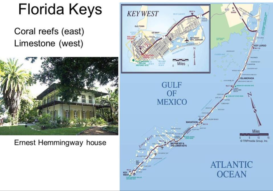
3
4 Setting the Boundaries What states and provinces are part of the region? Southeastern TX, southern LA, southern MS, southern AL, southern GA, all of FL, eastern SC, and eastern NC What regions does it border? Great Plains, Inland South, and Megaopolis

5
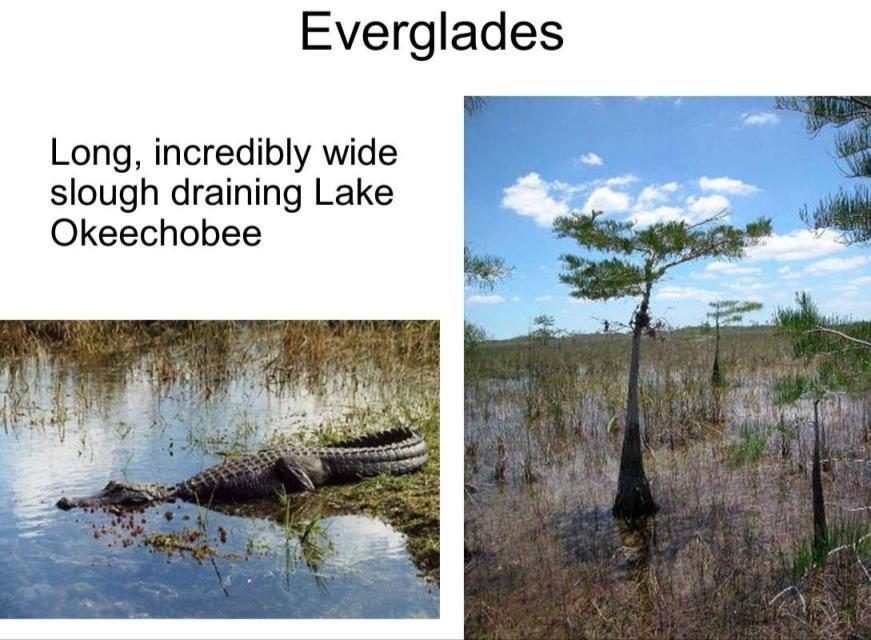
6 Physical Geography

7 Physical Setting Probably the flattest region of the 15 regions discussed in this class Poorly drained Components Sandy shallow coastline Barrier Islands Florida Peninsula Mississippi Delta Florida Keys

8 Coastline Very flat terrain Very shallow ocean Many meandering rivers Swamps common, lack of true coastline

9 Barrier Islands Shoals as geographic units Slowly migrating outward Intensely developed

10 Florida Peninsula Limestone Karst Caves Sinkholes Very high water table Lakes and artesian wells Complex drainage system

11 Florida Peninsula
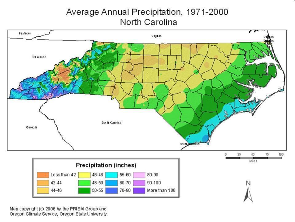
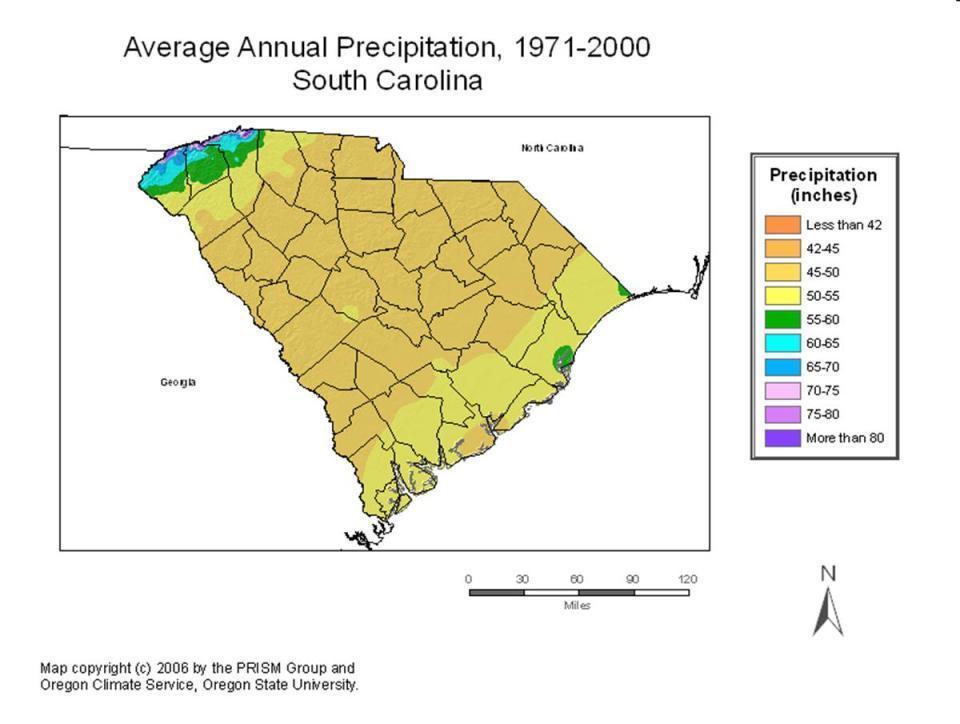
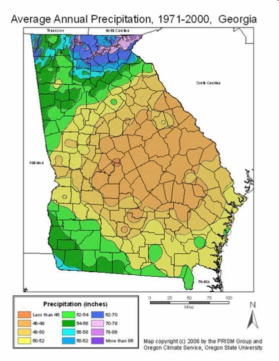
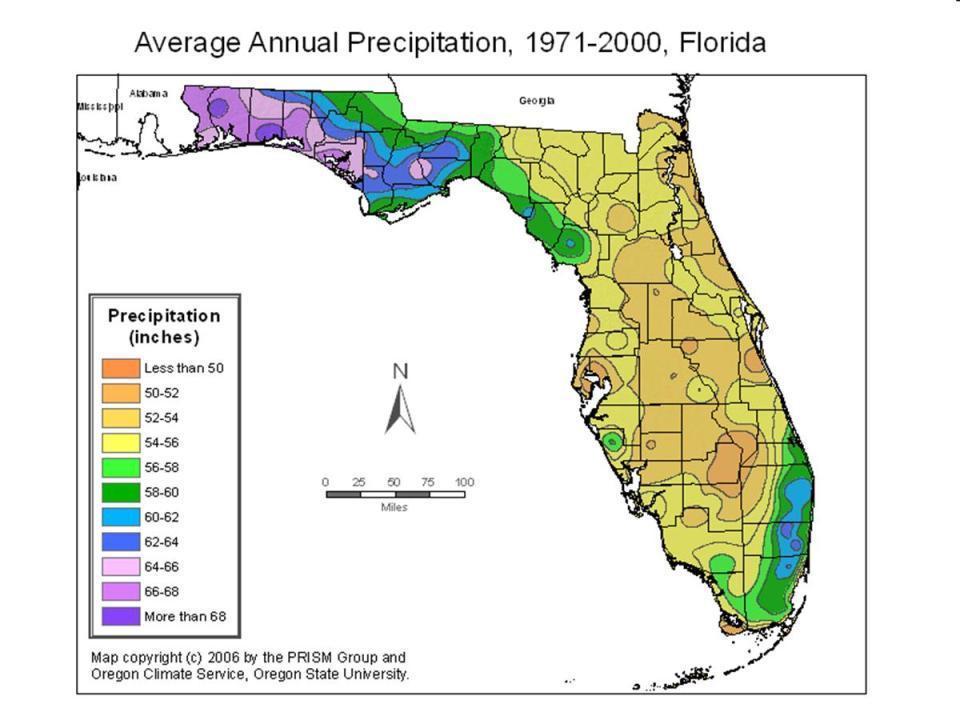
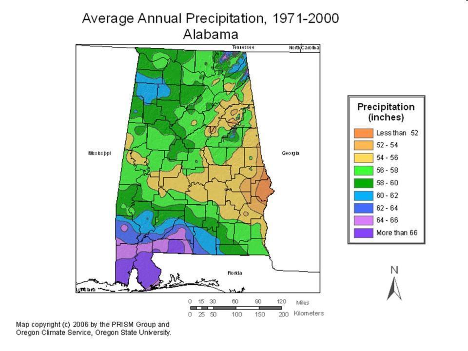
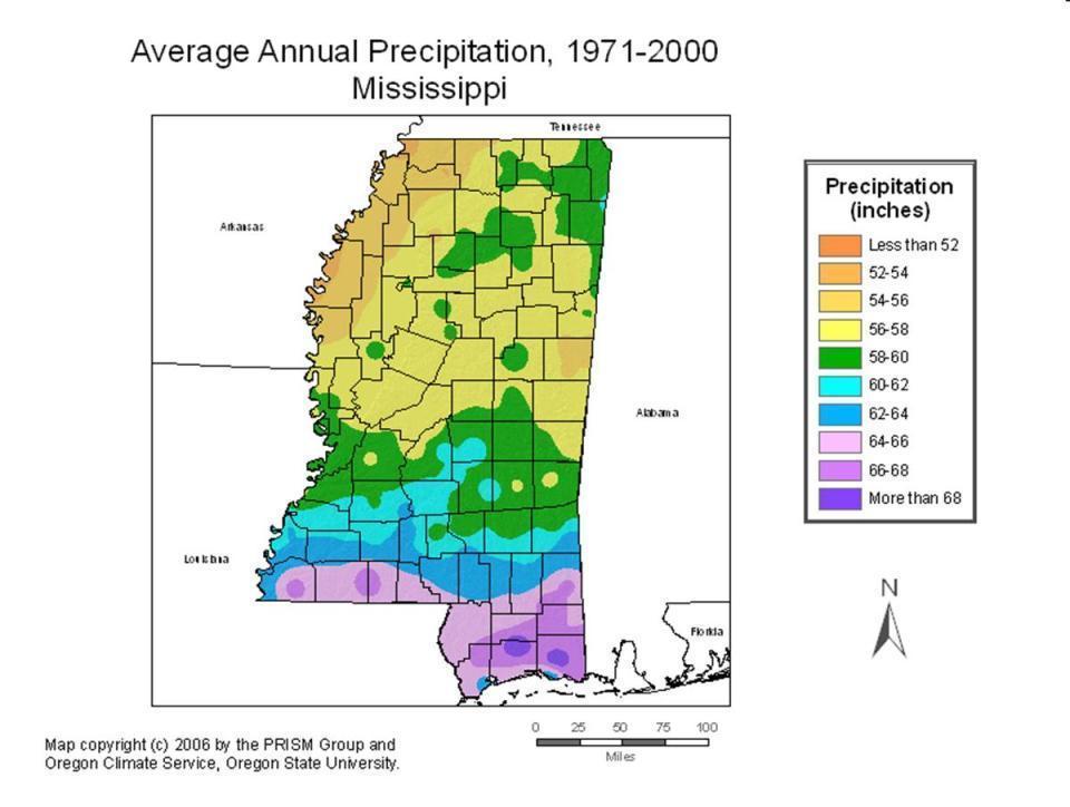
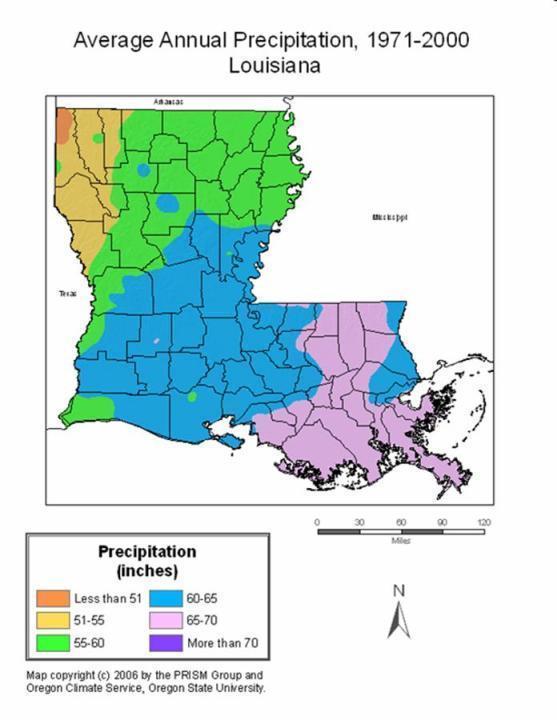
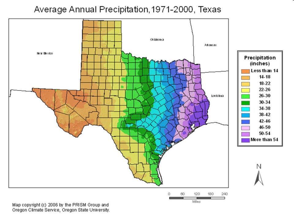
12
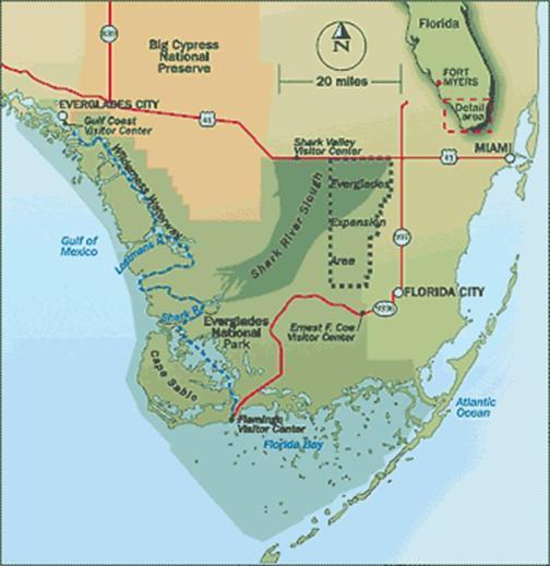
13 Everglades

14 Mississippi River Delta Landscape in transition Bayou
15
16

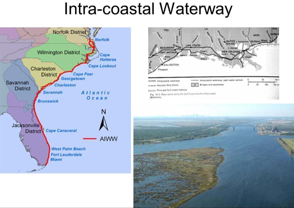
17 Intra-coastal Waterway The Intra-coastal Waterway is a 4,800-km (3,000-mile) waterway along the Atlantic and Gulf coasts of the United States. Some lengths consist of natural inlets, salt-water rivers, bays, and sounds; others are man-made canals. Enhances freight transport Extends across much of the region
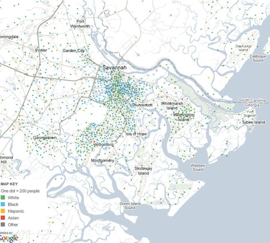
18
19 Climate Summer dominates Mild winter, though frosts occur in most places Heavy rainfall Very humid Hurricane prone
20
21 Climograph Wilmington, NC
22
23 Climograph Charleston, SC
24
25 Climograph Savannah, GA
26
27 Climograph Jacksonville, FL
28 Climograph Miami, FL
29 Climograph Tampa, FL
30
31 Climograph Mobile, AL
32
33

34 Climograph Baton Rouge, LA
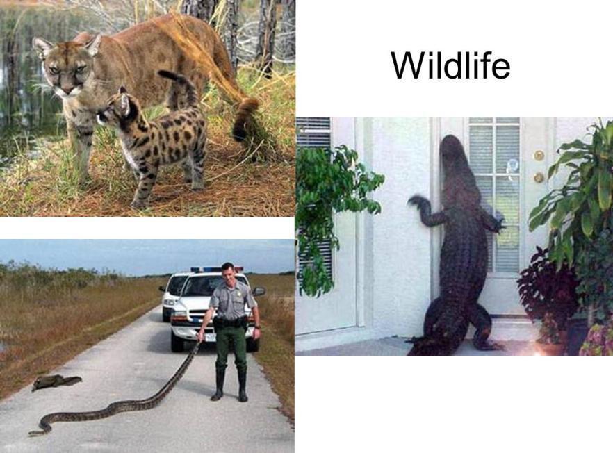
35
36 Climograph Houston, TX
37 Climograph Brownsville, TX
 Allowed Houston to surpass Galveston in regional")
38 Galveston, 1900 Hurricane Worst natural disaster in US History at the time It had estimated winds of 135 mph 6,000 killed in city (20% of the population) Allowed Houston to surpass Galveston in regional supremacy

39 Hurricane Katrina Hurricane Katrina was the costliest and one of the five deadliest hurricanes in the history of the U.S. It was the sixth-strongest Atlantic hurricane ever recorded and the thirdstrongest hurricane on record that made landfall in the United States
40 Climate Comparison Spokane WA Houston TX Miami FL Wilmington NC Jan Temp (F) 33 / / / / 35 Jul Temp (F) 82 / / / / 71 Rainfall 16.5 in. 45 in. 58 in. 54 in. Snowfall 49 in. 0 in. 0 in. 2 in.
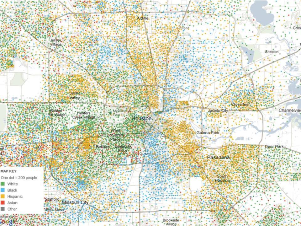
41 Soils & Landscape Sandy soils, clay, poorly drained Forest (pines and cypress) on more stable ground and located more to the east Grasslands near coast Everglades is an example with tall sawgrass
42 Wildlife Wintering ground for many birds Cougar Alligators Snakes Many exotic species flourish here Florida s climate can accommodate many species
43
44 Population & Settlement
45 Early Settlement Extremely varied/complex settlement French settlers came down the Mississippi and gradually spread along the coast British moved along the Atlantic shore (Georgia founded in 1773) Spanish settled Texas from Caribbean/Mexico
46 Settlement of Florida First permanent European settlement by Spanish (St. Augustine, 1565), evicted French settlers of a year earlier Camped by French on the west and English on north through 1700 s Ceded to Britain, 1763 Returned to Spain, 1781
47 Settlement of Florida Spanish settlers returned along with many Native Americans, Africans, Americans Ceded to US in 1821 Two Seminole Wars to evict native population, 1818 and
48 Contemporary Migration Cuban immigration to Florida Haitian immigration to Florida Mexican immigration to Texas Retirement immigration to entire region
49 Contemporary Migration Booming areas Houston Most of Florida peninsula Retirement areas of southern Texas, Carolinas Other areas with less growth New Orleans to Florida panhandle Charleston, Savannah
50 Population Numbers State/Province 2000 (1,000 s) 1990 (1,000 s) Change Florida 15,982 12, % Wilmington, NC % New Orleans 1,337 1,285 +4% Houston 4,670 3, % Brownsville, TX % US & Canada 312, , %

51 Population Density - NC

52 Population Density - SC

53 Population Density - GA

54 Population Density - FL

55 Population Density - AL

56 Population Density - MS

57 Population Density - LA

58 Population Density - TX
59 Human & Economic Geography

60 Fishisng Louisiana catch second only to Alaska in US Shrimp most places in gulf Many leading fishing port in the region
61 Forestry Turpentine and resin Half of the worlds output here Distilled from yellow pine Lumber and pulpwood
62 Forestry Difficult in many regions with poorly drained land Climate suitable for some crops not suitable in other areas Adequate moisture Winter crops grown for rest of US and Canada Most crops grown elsewhere are absent here (grains)

63 Citrus Florida, more than 75% of national output Also in Rio Grande Valley Danger from frosts has pushed dominant area south

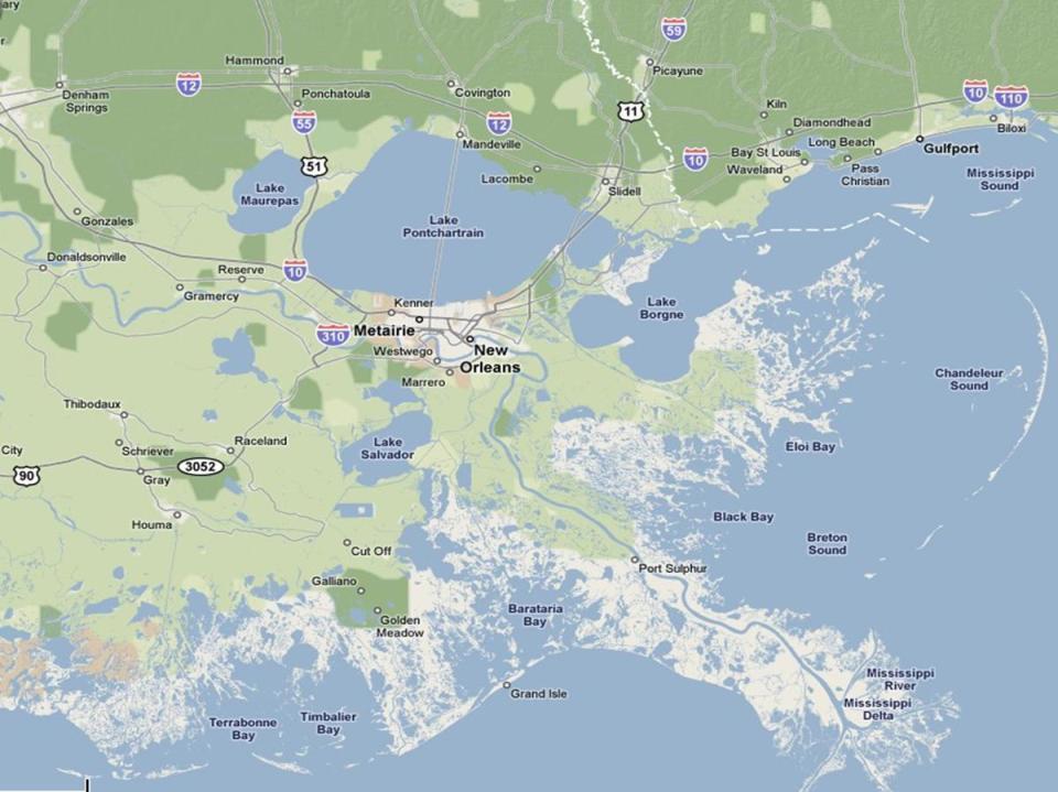
64 Winter Vegtables Tomatoes Peppers Squash Eggplant

65 Sugar Important historically Sugar plantations in Louisiana Current growth South Central and Southeast Louisiana Southeast Florida Increased in importance since Cuban sugar is prohibited

66 Crops & other Livestock Rice Used to extremely important in Carolina s in Georgia Cotton Tobacco Beef Coastal Louisiana, Texas, Florida
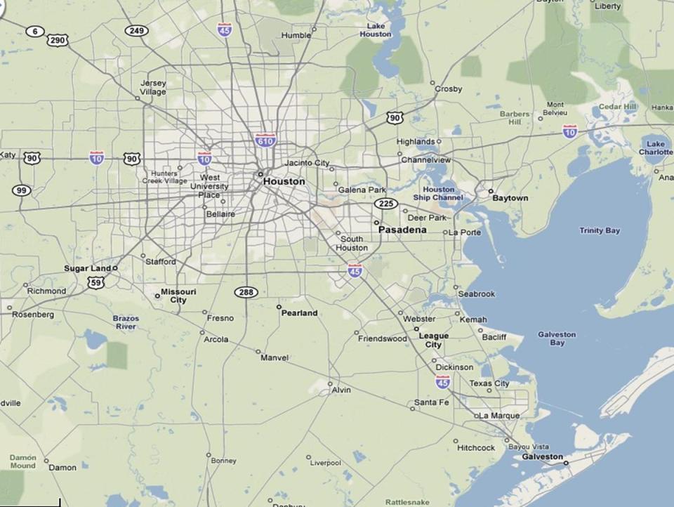
67 Mineral Industries Salt Sulfur Oil and Natural Gas Mouth of the Mississippi to the mouth of the Rio Grande off shore and near shore reserves Expanding industry, with better technology Many cities in the area have large refineries and shipping ports

68 Oil Drilling in the Gulf Already in western Gulf Proposed ending of moratorium in Eastern Gulf Significant environmental hazard with the BP Spill in 2010
69 Manufacturing Mostly, due to proximity of natural resources Petrochemicals Plastics Oil refinement Rubber Explosives

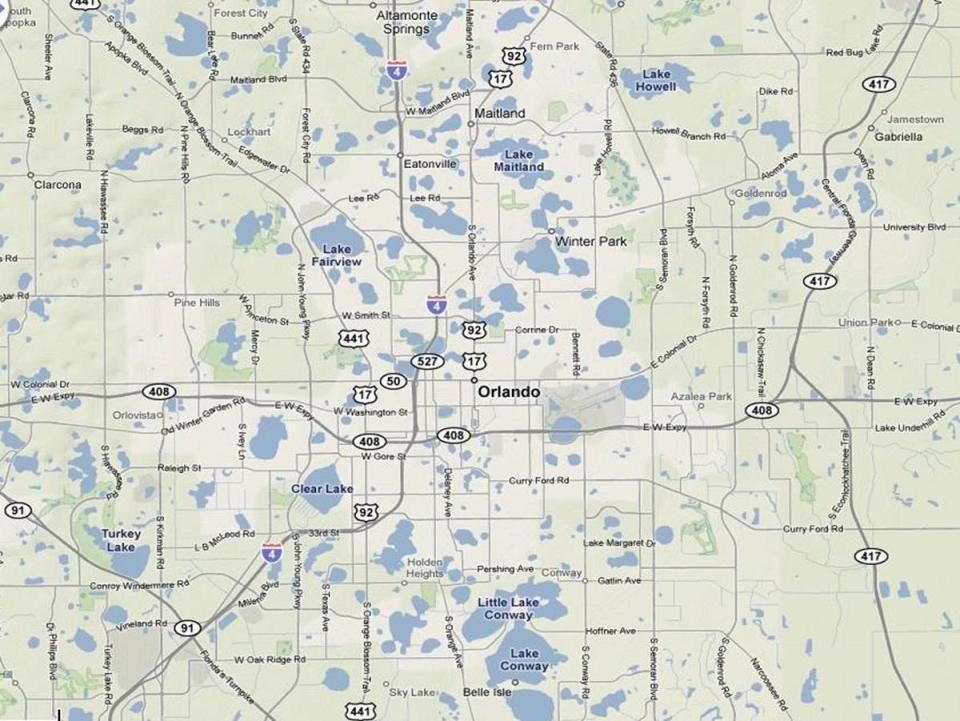
70 Tourism & Recreation Mostly beach or water-related Disney and other amusement parks in Orlando Winter haven Retirement center Cruise ship industry
71 Service Industry Large boom in retirement population Dramatic increase in employment in services for older population Large employment in tourist trade as well, particularly in Florida

72 New Orleans Enormous shipping port Only US major city below sea level Most French-cultured city in US Major tourist destination Slow growth Hit hard by Hurricane Katrina in 2004
73
74

75 Houston Fastest growing large city in country Busy port, industrial area Dominated by energy industry Space industry Largest US city without an amusement park close by
76
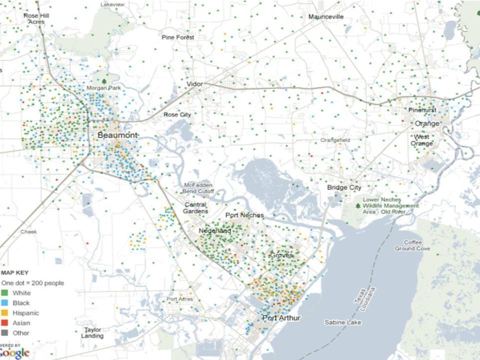
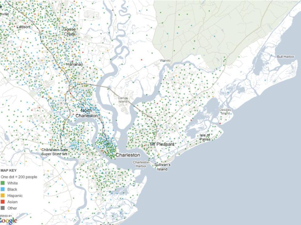
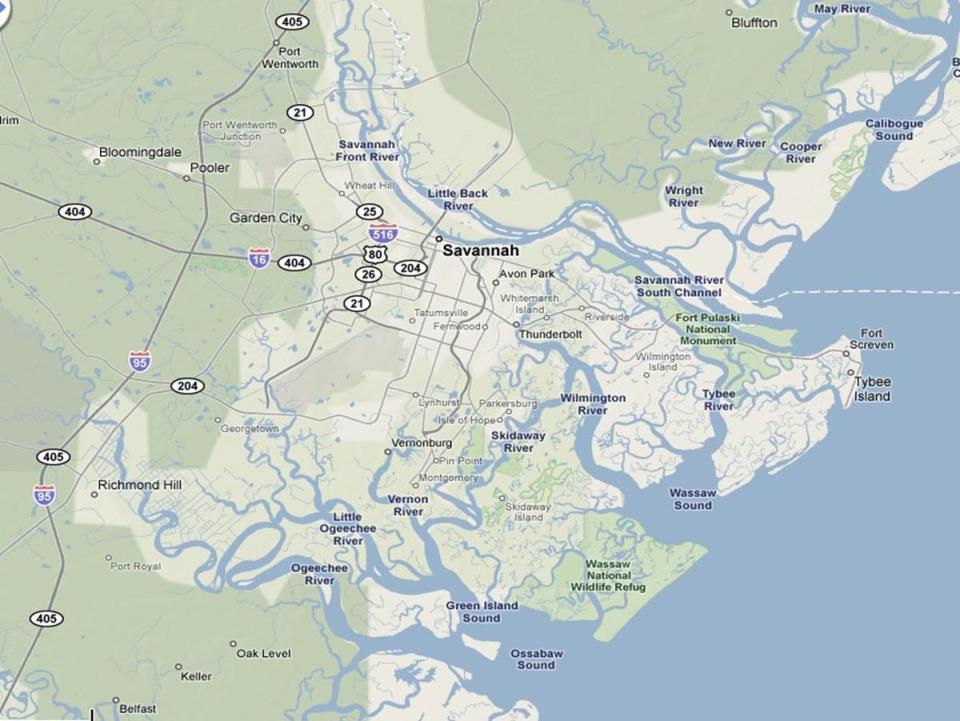
77
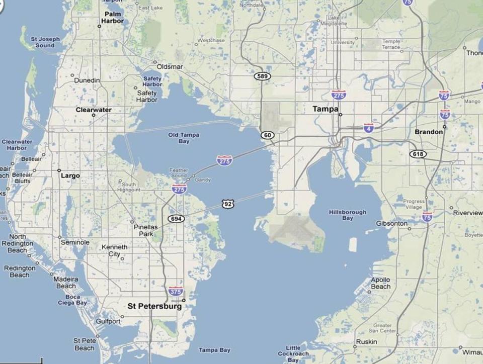
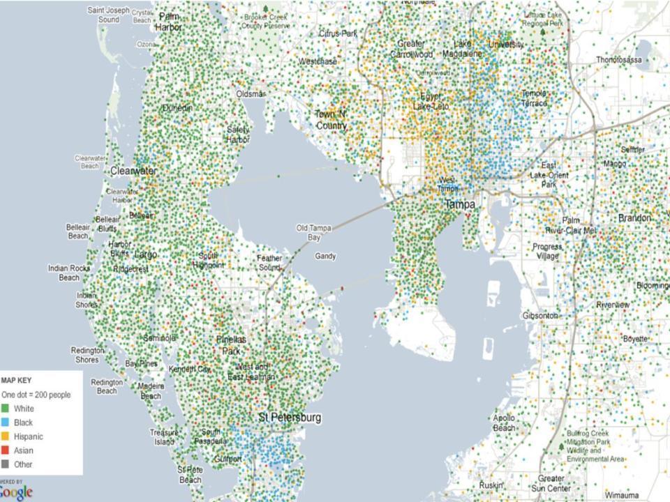
78 Other Florida Cities Large service sectors Tourism centers (especially Orlando) Retirement centers Most cities on peninsula rapidly growing Tampa 2.4 M., Orlando 1.6 M., West Palm Beach 1.1 M. Much of the coastal areas one large area of urban sprawl Jacksonville and other northern cities showing less growth
79
80
81

82
83
84
85 Other Cities Petroleum-based and Petrochemicals Baton Rouge Beaumont - Port Arthur Historic Industrial Cities Charleston Savannah Other Ports Mobile (steel) Brownsville (agriculture)
86
87
88
89
90
91
92 Outlook Future growth Petroleum industry and related manufacturing Expansion of port facilities Retirement centers Natural environment very sensitive to growth
EXAM TWO. The Southern Coastlands: on the subtropical margin. Highest point in Florida! near the Alabama border. The Southern Coastlands Region
 EXAM TWO Regional Landscapes of the United States and Canada The Southern Coastlands: on the subtropical margin Prof. Anthony Grande Thursday, April 18 Chapters 4-11. Same format as Exam One. Take-home
GEOGRAPHY OF THE UNITED STATES & CANADA. By Brett Lucas
 GEOGRAPHY OF THE UNITED STATES & CANADA By Brett Lucas THE CALIFORNIA REGION Setting the Boundaries What states and provinces are part of the region? Parts of CA and NV. What regions does it border? N.
Economy 3. This region s economy was based on agriculture. 4. This region produced items such as textiles, iron, and ships in great quantities. For th
 Geography 1. This region has a climate of warm summers and snowy cold winters. 2. This region has a climate that is generally warm and sunny, with long, hot, humid summers, and mild winters, and heavy
Latin America and The Caribbean. A Closer Look.
 Latin America and The Caribbean A Closer Look. Mexico Capital: Mexico City The Location of Mexico Mexico is the second-largest country by size and population in Latin America.but the Largest Spanish -
4th Grade Social Studies 2nd Nine Weeks Test
 4th Grade Social Studies 2nd Nine Weeks Test Multiple Choice Identify the choice that best completes the statement or answers the question. 1 Which is the largest city in the United States? A Philadelphia,
GEOGRAPHY OF THE UNITED STATES & CANADA. By Brett Lucas
 GEOGRAPHY OF THE UNITED STATES & CANADA By Brett Lucas MEGALOPOLIS Setting the Boundaries What states and provinces are part of the region? Primarily the east coast between Norfolk, VA and Boston, MA,
Warm ups *What was the most valuable natural resource in the development of the Northeast? Why? *What does a megalopolis refer to?
 Warm ups 9.22.2016 *What was the most valuable natural resource in the development of the Northeast? Why? *What does a megalopolis refer to? Lesson Objective: *identify the key natural resources that influenced
Brain Wrinkles. Location, Climate, & Natural Resources of. Where People Live & How They Trade
 Location, Climate, & Natural Resources of Where People Live & How They Trade It s south of the US, east of the Pacific Ocean, and west of the Gulf of Mexico & Caribbean Sea. It s great that it s located
The Land Photo Source: The Atlas of Canada, The Red River, Manatoba, Canada land/physio_red_ri
 The Land The United States and Canada An Overview of the Region The United States and Canada are the two largest countries in North America. The Rio Grande is part of the southwest border of the United
Latin America 11/4/2013. Latin America Today. 580 million people 9% of the world s population Diverse backgrounds:
 Latin America Chapter 10 Human Geography Latin America Today 580 million people 9% of the world s population Diverse backgrounds: Native Americans Europeans Africans Asians 1 Population 393 million live
STANDARDS: Brain Wrinkles
 STANDARDS: SS6G3 The student will explain the impact of location, climate, distribution of natural resources, and population distribution on Latin America and the Caribbean. a. Compare how the location,
Region 1 Piney Woods
 Region 1 Piney Woods Piney Woods 1. This ecoregion is found in East Texas. 2. Climate: average annual rainfall of 36 to 50 inches is fairly uniformly distributed throughout the year, and humidity and temperatures
Florida Dixie DAY 01: Miami, FL Overnight: Best Western Atlantic Beach Resort or similar Day 02 Miami, FL Orlando, FL
 DAY 01: Miami, FL Transfer to your Miami hotel and spend the afternoon discovering the South Beach, famed for its colorful art deco buildings, white sand, surfside hotels and trendsetting nightclubs. Overnight:
SS8G1 The student will describe Georgia with regard to physical features and location.
 SS8G1ab Standards SS8G1 The student will describe Georgia with regard to physical features and location. a. Locate Georgia in relation to the region, nation, continent, and hemispheres. b. Describe the
2015 Brain Wrinkles. SS8G1b
 SS8G1b Georgia is a geographically diverse state that is divided into five regions. The first three regions (Appalachian Plateau, Valley and Ridge, and Blue Ridge) are in the mountains and foothills of
SAND TIGER SHARK (SoC)
") Ranking (Economic) Potentially Impacted Navigation s 2 Galveston SWD HOUSTON SHIP CHANNEL (0007780) TX X 4 New York NAD NEW YORK HARBOR (0012490) NY X 10 New York NAD NEW YORK AND NEW JERSEY HARBOR, NY
Ranking (Economic) Potentially Impacted Navigation s 2 Galveston SWD HOUSTON SHIP CHANNEL (0007780) TX X 4 New York NAD NEW YORK HARBOR (0012490) NY X 10 New York NAD NEW YORK AND NEW JERSEY HARBOR, NY
What Is An Ecoregion?
 Ecoregions of Texas What Is An Ecoregion? Ecoregion a major ecosystem with distinctive geography, characteristic plants and animals, and ecosystems that receives uniform solar radiation and moisture Sometimes
ENGLISH COLONIES CHAPTER 3
 ENGLISH COLONIES CHAPTER 3 NEW ENGLAND COLONIES Colonies MA PLYMOUTH, MA BAY, NH, CT, RI Climate/Geography bitterly cold winters and mild summers; SHORT GROWING SEASONS! Land was flat close to the coastline
WORLD GEOGRAPHY. Hector Rodriguez
 Mr. Chavira 9th Period WORLD GEOGRAPHY Hector Rodriguez P a g e 1 Table of Contents Latin America Page 2 o Maps Economic Map Page 3 Political Map Page 4 Population Map Page 5 Physical Page 6 o Notes Physical
GEOGRAPHY OF THE UNITED STATES & CANADA. By Brett Lucas
 GEOGRAPHY OF THE UNITED STATES & CANADA By Brett Lucas THE HEARTLAND REGION Setting the Boundaries What states and provinces are part of the region? Parts of SD, NE, KS, MN, WI, MI, Ontario, NY, KY, TN,
Chapter 20. The Physical Geography of Africa South of the Sahara
 Chapter 20 The Physical Geography of Africa South of the Sahara Chapter Objectives Identify the major landforms, water systems, and natural resources of Africa south of the Sahara. Describe the relationship
GEOGRAPHY AND HISTORY
 GEOGRAPHY AND HISTORY YEAR 1, PART 1 www.vicensvives.es Contents 01 Our planet Earth 02 The representation of the Earth: maps 03 The Earth s relief 04 Rivers and seas 05 Weather and climate 06 Climates
Location, Climate, & Natural Resources
 Location, Climate, & Natural Resources UK is a country of islands off the coast of mainland Europe. It consists of England, Northern Ireland, Scotland, & Wales. UK s location makes it a HUB for trade.
Delivering the Goods: Ports in the South
 Delivering the Goods: Ports in the South Sujit M. CanagaRetna The Council of State Governments Southern Legislative Conference (SLC) Atlanta, Georgia Presentation to the Southern Economic Development Council
The Northern Tropics
 The Northern Tropics The Guianas Countries Guyana, Suriname, French Guyana Culture reflects colonial history Official Languages Guyana English Suriname Dutch French Guyana - French Religions Suriname and
Curriculum Pacing Guide Grade/Course 5 Th Grade Geography Grading Period 1 st Nine Weeks
 2013-2014 Curriculum Pacing Guide Grade/Course 5 Th Grade Grading Period 1 st Nine Weeks Time Frame Unit/ photographs, pictures, and tables to Locate and identify: Continents and Oceans -North America
MCGRAW-HILL EUROPE. Chapter 11 Physical Geography Pages 332 to 341
 MCGRAW-HILL EUROPE Chapter 11 Physical Geography Pages 332 to 341 Countries of Western Europe Benelux Countries UK, France, Luxembourg, Germany, Netherlands, Belgium, Austria, Switzerland, Belgium, Monaco,
Location, Climate, & Natural Resources Brain Wrinkles
 Location, Climate, & Natural Resources Standards SS6G10 The student will explain the impact of location, climate, natural resources, and population distribution on Europe. a. Compare how the location,
2015 Brain Wrinkles. SS8G1b
 SS8G1b Standards SS8G1 The student will describe Georgia with regard to physical features and location. b. Describe the five geographic regions of Georgia; include the Blue Ridge Mountains, Valley and
Size data for all Gulf areas are available starting Fishing areas in the Headboat survey are described in Table 1.
 SEDAR7 - DW - 46 Size frequency distribution of red snapper from dockside sampling of recreational landings in the Gulf of Mexico 1984-22 (TXPW, MRFSS, and s size data) by Guillermo A. Diaz Southeast Fisheries
Geography: Unit 2. Map. Rivers. Major Physical Features. Slide 1. Slide 2. Slide 3. Slide 4. North America United States and Canada.
 Mississippi River Slide 1 Slide 2 Slide 3 Slide 4 Geography: Unit 2 North America United States Map Major Physical Features Mountain Ranges Brooks Range Mackenzie Mountains Coast Mountains Cascades Sierra
LOCATION, LOCATION, LOCATION! Mexico, Venezuela, Cuba, and Brazil
 LOCATION, LOCATION, LOCATION! Mexico, Venezuela, Cuba, and Brazil GPS and E.Q. GPS: SS6G3 The student will explain the impact of location, climate, distribution of natural resources, and population distribution
Southern Africa. Countries, Geography, & Climate
 Countries, Geography, & Climate The Southern African region consists of the following countries: Angola Zambia Malawi Mozambique Zimbabwe Botswana Namibia Swaziland Lesotho South Africa Comoros Madagascar
Varied Lands and Varied Resources Chapter 9 Lesson 1
 Varied Lands and Varied Resources Chapter 9 Lesson 1 16 independent countries make up region of Europe From in north to Balkan Peninsula in south Eastern Europe four separate sub regions Western Balkans
LOCATION, CLIMATE, AND NATURAL RESOURCES OF MEXICO
 SS6G3 The student will explain the impact of location, climate, distribution of natural resources, and population distribution on Latin America and the Caribbean. a. Compare how the location, climate,
2018 Spring Semester Final : STUDY GUIDE
 Name: Hr: 2018 Spring Semester Final : STUDY GUIDE My final is on:, May My final will have questions and will be COLONIZATION OF NORTH & SOUTH AMERICA - Match the regions with the European countries that
Short Tons (Thousands) Metric Tons (Thousands)
 Metric Tons (Thousands)") Hampton Roads Harbor 2017 Trade Overview 0.907185 1.10231 TOTAL EXPORT IMPORT Total Cargo 62,578.98 56,770.76 Total Cargo 50,552.13 45,860.17 Total Cargo 12,026.85 10,910.59 General Cargo 21,971.71 19,932.41
Hampton Roads Harbor 2017 Trade Overview 0.907185 1.10231 TOTAL EXPORT IMPORT Total Cargo 62,578.98 56,770.76 Total Cargo 50,552.13 45,860.17 Total Cargo 12,026.85 10,910.59 General Cargo 21,971.71 19,932.41
ACEC/MW and ACEC/MD. Maryland Port Administration. Steve Johnson. June 6, 2017
 ACEC/MW and ACEC/MD Maryland Port Administration Steve Johnson June 6, 2017 1 The Port of Baltimore is a complex mix of Private and Public terminals.handling diverse bulk & general cargoes. Baltimore Forest
Brazil. Chapter 12. Chapter 12, Section
 Chapter 12, Section World Geography Chapter 12 Brazil Copyright 2003 by Pearson Education, Inc., publishing as Prentice Hall, Upper Saddle River, NJ. All rights reserved. Chapter 12, Section World Geography
Chapter 16 ~ Eastern Mediterranean
 Chapter 16 ~ Eastern Mediterranean Physical Geography of the Eastern Mediterranean Landforms This area is known as the Levant and includes Syria, Jordan, Lebanon, Israel, and the Palestinian territories.
Chapter 16 ~ Eastern Mediterranean
 Chapter 16 ~ Eastern Mediterranean Physical Geography of the Eastern Mediterranean Landforms This area is known as the Levant and includes Syria, Jordan, Lebanon, Israel, and the Palestinian territories.
Geography Unit: North America Section: Physical Characteristics and Systems of North America. Tutorial: Regions of North America
 Geography Unit: North America Section: Physical Characteristics and Systems of North America Tutorial: Regions of North America Regions of North America Welcome to the tutorial about the regions of North
Chapter 3. The English Colonies
 Chapter 3 The English Colonies Terms 1. Indentured servants 2. Cash crops 3. Assembly 4. Puritans 5. Mayflower Compact 6. Slave trade 7. Fundamental orders Massachusetts- 1630 Founders- William Bradford
1st Period Mr. Chavira WORLD GEOGRAPHY. Hector Rodriguez
 1st Period Mr. Chavira WORLD GEOGRAPHY Hector Rodriguez P a g e 1 Table of Contents Latin America Page 2 o Maps Economic Map Page 3 Political Map Page 4 Population Map Page 5 Physical Page 6 o Notes Physical
Mexico. Chapter 10. Chapter 10, Section
 Chapter 10, Section World Geography Chapter 10 Mexico Copyright 2003 by Pearson Education, Inc., publishing as Prentice Hall, Upper Saddle River, NJ. All rights reserved. Chapter 10, Section World Geography
Physical Regions of the U.S.
 Physical Regions of the U.S. Quickly use this map to label the map on your paper Pacific Coast The coast from southern California to Alaska The region of the Pacific Northwest has a long history that was
Latin America. Introduction
 Latin America Introduction What are the 5 Themes of Geography? Draw lines to connect the theme to the definition: Location How humans and the environment impact each other Physical and human characteristics
4th Grade Third 9 Weeks Test
 4th Grade Third 9 Weeks Test Multiple Choice Identify the choice that best completes the statement or answers the question. 1 A waterway for ships that is dug across land is called a. A port C river B
Why is the US industry and agriculture prosperous? The US industry and agriculture is so prosperous because it has many different natural resources.
 Ch. 1-7 Study Guide Why is the US industry and agriculture prosperous? The US industry and agriculture is so prosperous because it has many different natural resources. What likely drew immigrants to the
South America. pg. 520 (5 th) pg. 523 (6 th )
 pg. 523 (6 th )") South America pg. 520 (5 th) pg. 523 (6 th ) Venezuela Rich in Oil Lake Maracaibo Called Little Venice pg. 572 (5 th) pg. 574 (6 th ) Caracas 8 miles Inland 3000 pg. 572 (5 th) pg. 574 (6 th ) Caracas
South America pg. 520 (5 th) pg. 523 (6 th ) Venezuela Rich in Oil Lake Maracaibo Called Little Venice pg. 572 (5 th) pg. 574 (6 th ) Caracas 8 miles Inland 3000 pg. 572 (5 th) pg. 574 (6 th ) Caracas
North Africa. Chapter 25. Chapter 25, Section
 Chapter 25, Section World Geography Chapter 25 North Africa Copyright 2003 by Pearson Education, Inc., publishing as Prentice Hall, Upper Saddle River, NJ. All rights reserved. Chapter 25, Section World
Galveston County. Population: 322,225 (2015 est.) Access to 2 deep water ports. Location of a world class industrial complex
 Access to 2 deep water ports. Location of a world class industrial complex") Galveston County Galveston County Population: 322,225 (2015 est.) Access to 2 deep water ports Location of a world class industrial complex Benefits of the Houston Metro without the big city congestion
Galveston County Galveston County Population: 322,225 (2015 est.) Access to 2 deep water ports Location of a world class industrial complex Benefits of the Houston Metro without the big city congestion
Student Reading 13.10: The Regions of Ohio
 Student Reading 13.10: The Regions of Ohio Ohio has five natural regions which formed more than 10,000 years ago. A natural region is an area that shares the same natural features. These places have similar
Chapter 17. North Africa, Southwest Asia and Central Asia
 Chapter 17 North Africa, Southwest Asia and Central Asia Chapter Objectives Describe the major landforms and natural resources of North Africa, Southwest Asia, and Central Asia. Discuss the climate and
Nicaragua versus Costa Rica?
 Nicaragua versus Costa Rica? Overview: Today I want to look at Nicaragua versus Costa Rica from both a destination for retiree s standpoint and for potential investment interest. First I'll provide some
TOTAL DOMESTIC TRADE RANK TOTAL FOREIGN TRADE
 U.S. PORT RANKING BY CARGO VOLUME 2016 Short Tons FOREIGN TRADE TOTAL TRADE TOTAL DOMESTIC TRADE RANK IMPORTS EXPORTS TOTAL FOREIGN TRADE RANK RANK RANK RANK PORT/STATE TONS PORT/STATE TONS PORT/STATE
STUDY GUIDE. The Land. Chapter 29, Section 1. Both. Terms to Know DRAWING FROM EXPERIENCE ORGANIZING YOUR THOUGHTS
 Chapter 29, Section 1 For use with textbook pages 719 724. The Land Terms to Know cordilleras Parallel mountain ranges and plateaus (page 719) archipelago A group of islands (page 720) insular Relating
The Geological Pacific Northwest. Wednesday February 6, 2012 Pacific Northwest History Mr. Rice
 The Geological Pacific Northwest Wednesday February 6, 2012 Pacific Northwest History Mr. Rice 1 Free Response #2 Please do not simply list the items for this response. Full sentences!!! Minimum of 3-5
Short Tons (Thousands) Metric Tons (Thousands)
 Metric Tons (Thousands)") Hampton Roads Harbor 2016 Trade Overview 0.907185 1.10231 TOTAL EXPORT IMPORT Total Cargo 50,313.70 45,643.88 Total Cargo 38,661.73 35,073.37 Total Cargo 11,651.98 10,570.51 General Cargo 20,869.31 18,932.33
Hampton Roads Harbor 2016 Trade Overview 0.907185 1.10231 TOTAL EXPORT IMPORT Total Cargo 50,313.70 45,643.88 Total Cargo 38,661.73 35,073.37 Total Cargo 11,651.98 10,570.51 General Cargo 20,869.31 18,932.33
Geography: Unit 2. Map. Major Physical Features. Rivers. Mississippi River Missouri River Ohio River Rio Grande. Mackenzie. Colorado River Green River
 1 2 3 4 Geography: Unit 2 North America United States and Canada Map Major Physical Features Mountain Ranges Brooks Range Mackenzie Mountains Coast Mountains Cascades Sierra Nevada Rocky Mountains Appalachian
Leasing Brochure. Park Plaza Shopping Center 1150 N. Federal Highway, Pompano Beach, Florida Under Construction - Coming Very Soon
 Park Plaza Shopping Center 1150 N. Federal Highway, Pompano Beach, Florida 33062 Leasing Brochure Under Construction - Coming Very Soon Exclusive Leasing Broker 2048 East Sample Road, Lighthouse Point,
Lesson 1: Land and Climate of the West Land and Water of the West 1. There are 13 states in the West, divided into 3 regions a. Southwest: Nevada,
 Lesson 1: Land and Climate of the West Land and Water of the West 1. There are 13 states in the West, divided into 3 regions a. Southwest: Nevada, Utah, Arizona, New Mexico b. Mountain States: Wyoming,
CH. 1 Europe and Russia: Physical Geography. Section 1 Land and Water p Europe and Russia are part of the world s largest landmass called.
 CH. 1 Europe and Russia: Physical Geography Section 1 Land and Water p.10-16 Europe and Russia are part of the world s largest landmass called. The country of Russia stretches over both continents. About
Georgia s Brain Wrinkles. SS8G1c
 Georgia s 2015 Brain Wrinkles SS8G1c There are many different physical features in the state of Georgia. Physical features include bodies of water, deserts, mountain ranges, and other landforms. They are
There are actually six geographic sub-regions, three in both the uplands and the lowlands.
 6 Regions of AR Although Arkansas is most easily divided into two distinct geographical regions, the northwestern uplands and the southeastern lowlands, this description does not accurately portray the
Today there are 564 federally
 on location: south dave bodle Going Native in Florida The Seminole and Miccosukee tribes offer a variety of itinerary options in the Sunshine State 18 February 2011 LeisureGroupTravel.com Seminole culture
Geographic Response Plan Map: EFL-40 ]^4011. ! Manatee [v NERR. National Park. Naval Facility. Piping Plover. Power Plant. Recreational Fishing
![Geographic Response Plan Map: EFL-40 ]^4011. ! Manatee [v NERR. National Park. Naval Facility. Piping Plover. Power Plant. Recreational Fishing](/thumbs/91/105050028.jpg "Geographic Response Plan Map: EFL-40 ]^4011. ! Manatee [v NERR. National Park. Naval Facility. Piping Plover. Power Plant. Recreational Fishing") 29 22'30"N 81 7'30"W!E(! EFL40-01 Basin Bulow Creek State Park Addison Blockhouse Historic State Park NRC - Ormond Beach Warehouse Equipment Site (ID JAX-E8) River Basin k k Marsh Aquatic Preserve!S( 200
29 22'30"N 81 7'30"W!E(! EFL40-01 Basin Bulow Creek State Park Addison Blockhouse Historic State Park NRC - Ormond Beach Warehouse Equipment Site (ID JAX-E8) River Basin k k Marsh Aquatic Preserve!S( 200
The Galveston Seawall
 Coastal and Ocean Engineering ENGI.8751 Undergraduate Student Forum Faculty of Engineering and Applied Science, Memorial University, St. John s, NL, Canada. March, 2013 The Galveston Seawall Mark Harvey
Sheffield Island Camden County, GA
 For Sale $3,150,000 Sheffield Island Camden County, GA 452.5 Total Acres 230 Estimated Upland Acres William Lattimore 912.596.7019 Overview A rare opportunity to own a portion of a pristine island off
CANADA: ITS LAND, RESOURCES, & ECONOMY PRE-TEST
 PRE-TEST Name Directions: In the blank space, write a "T" if the statement is true and an "F" if the statement is false. 1. Canada has 11 geographic regions. 2. The cordillera is found in central Canada.
STUDY GUIDE. The Land. Physical Features of Latin America. Chapter 8, Section 1. Terms to Know DRAWING FROM EXPERIENCE ORGANIZING YOUR THOUGHTS
 For use with textbook pages 193 198. The Land Terms to Know cordillera A mountain range that runs parallel to another mountain range (page 194) altiplano A high plain (page 194) escarpment A steep cliff
TEXAS PORTS Value to the Nation
 TEXAS PORTS Value to the Nation Col. Christopher W. Sallese District Commander, Galveston District U.S. Army Corps of Engineers March 18, 2013 Houston-Galveston Area Council US Army Corps of Engineers
LATIN AMERICA. Mexico, Central America and South America
 LATIN AMERICA Mexico, Central America and South America Physical Geography: Plate tectonics pushing together formed what major mountain range?? Andes Mountains Natural disasters the area is prone to:
North Carolina from the Mountains to the Sea
 North Carolina from the Mountains to the Sea Dr. Jennifer Frick-Ruppert Brevard College Cover of Mountain Nature: A Seasonal Natural History of the Southern Appalachians. 2010. UNC Press High Biodiversity
 Chapter Name Albuquerque Ann Arbor Augusta Baton Rouge Bayou Oncology (C'est Bon) Big Sky Bluegrass Blue Ridge of Virginia Bluewater International Boston Broward Florida Bucks Montgomery Counties California
OKLAHOMA HISTORY OKLAHOMA S GEOGRAPHY
 OKLAHOMA HISTORY OKLAHOMA S GEOGRAPHY BOARD QUESTIONS 1) HOW BIG IS OKLAHOMA? 2) HOW MANY COUNTIES ARE IN OKLAHOMA? 3) HOW FAR IS IT FROM OKC TO LAS ANGLES, CALIFORNIA? 4) HOW MANY STATE BORDER OKLAHOMA?
Chapter 7 Geography and the Early Settlement of Egypt, Kush, and Canaan
 Chapter 7 Geography and the Early Settlement of Egypt, Kush, and Canaan How did geography affect early settlement in Egypt, Kush, and Canaan? Section 7.1 - Introduction RF/NASA//Corbis This satellite photograph
AT A GLANCE ANDAMAN AND NICOBAR ISLANDS AND TROPICAL ISLAND NATIONS
 Geographical Information CHAPTER 19 AT A GLANCE ANDAMAN AND NICOBAR ISLANDS AND TROPICAL ISLAND NATIONS Name of island Ocean where located Longitude Latitude No. of islands Andaman and Nicobar Bay of Bengal
INTRODUCTION 250,000
 INTRODUCTION The United States of America has over 250,000 rivers, with a total of about 3,500,000 miles of rivers. The main stems of 38 rivers in the United States are at least 500 miles (800 km) long.
Hungry 4 History Trivia VA Studies 2010 and beyond
 Hungry 4 History Trivia VA Studies 2010 and beyond Level 1 1 What may be described using terms that show connections between two places such as: next to, near, or bordering? 2 3 What two large bodies of
Chapter 14. The Physical Geography of Russia
 Chapter 14 The Physical Geography of Russia Chapter Objectives Identify the physical features and natural resources of Russia. Discuss the effects of Russia s climate and vegetation on life in the region.
Ancient Egypt and the Near East
 *O*»f ' i ft Ancient Egypt and the Near East Chapter 7 Chapter 8 Chapter 9 Geography and the Early Settlement of Egypt, Kush, and Canaan The Ancient Egyptian P h a r a o h s Daily Life in Ancient Egypt
World. Drive Holidays. Roadtrip Los Angeles to Orlando 17 Days / 16 Nights
 Coast 2 Coast - The Ultimate American Road Trip Roadtrip Los Angeles to Orlando 17 Days / 16 Nights Available Summer, Autumn, Spring For most of us, the term Road Trip takes us back to a simpler time in
Brain Wrinkles. Africa: The impact of location, climate, & physical characteristics on where people live, the type of work they do, & how they travel
 Africa: The impact of location, climate, & physical characteristics on where people live, the type of work they do, & how they travel STANDARDS: SS7G3 The student will explain the impact of location, climate,
COUNTRY DATA: Cuba : Information from the CIA World Factbook
 COUNTRY DATA: Cuba : Information from the CIA World Factbook INTRODUCTION The native Amerindian population of Cuba began to decline after the European discovery of the island by Christopher COLUMBUS in
THE CRUISE INDUSTRY IN
 Economic Benefit of the Cruise Industry in Alaska Alaska benefits from the cruise industry as the premiere cruise destination market in the United States. In 2010, Alaska accounted for $930 million in
State of the Waterway 2017
 State of the Waterway 2017 Steven W. Nerheim Director VTS Houston/Galveston Lone Star Harbor Safety Committee 2 FEBRUARY 2018 U.S. Port Rankings 2015 1 South Louisiana, LA, Port of 259.1-3.07% 15 Texas
CHAPTER 1. INTRODUCTION AND BACKGROUND
 SETTING CHAPTER 1. INTRODUCTION AND BACKGROUND The City and Borough of Juneau (CBJ) is located in the central portion of the Alaskan panhandle, approximately 700 miles from Anchorage and 950 miles from
World History: Patterns of Interaction
 The Americans: A Separate World, 40,000 B.C. A.D. 700 Although early American civilizations remain mysterious, we know that the earliest Americans most likely migrated from Asia and that complex cultures
Chapter 7. Geography and the Early Settlement of Egypt, Kush, and Canaan
 Chapter 7 Geography and the Early Settlement of Egypt, Kush, and Canaan Chapter 7 Geography and the Early Settlement of Egypt, Kush, and Canaan How did geography affect early in Egypt Kush, and Canaan?
Match the names below with their locations on the map by writing the correct letter in the blank.
 P r e v i e w Match the names below with their locations on the map by writing the correct letter in the blank. Physical Features of Canada 60ºN 70ºN 80ºN A R C T I C O C E A N 130ºW 120ºW 110ºW 90ºW 70ºW
Friday, November 10, 2017
 Friday, November 10, 2017 Andes and Midlatitude Countries Objective: Summarize the main physical features and regions of the Southern Cone. Identify and locate the urban centers and understand the pattern
Physical Geography of Europe. Chapters 13-18
 Physical Geography of Europe Chapters 13-18 The British Isles Archipelago made of 6000+ small islands Temperate climate Largest body of fresh water is Loch Ness Mostly rolling hills and large flat lands
Rivers. Highlights of some of the World s Most Famous Rivers!
 Rivers Highlights of some of the World s Most Famous Rivers! Directions This Power Point presentation contains information about some of the most famous rivers in the world! Students should use this presentation
Physical Oceanographic Real-Time System (PORTS ) Funding Model
 Funding Model") Physical Oceanographic Real-Time System (PORTS ) Funding Model Richard Edwing, Director Center for Operational Oceanographic Products and Services AAPA Harbors & Navigation Committee Meeting Jacksonville,
Physical Oceanographic Real-Time System (PORTS ) Funding Model Richard Edwing, Director Center for Operational Oceanographic Products and Services AAPA Harbors & Navigation Committee Meeting Jacksonville,
SS7G1 The student will locate selected features of Africa.
 Standards SS7G1 The student will locate selected features of Africa. a. Locate on a world and regional political-physical map: the Sahara, Sahel, savanna, tropical rain forest, Congo River, Niger River,
LATIN AMERICA. Mexico Central America Caribbean Islands South America
 LATIN AMERICA Mexico Central America Caribbean Islands South America HISTORY First Settlers Hunters/gatherers from Asia crossed land bridge connecting Asia and Alaska Learned to farm over time Maize (corn)
Geography of Qatar. Contents. State Borders. al-khor, Qatar. Photo Flickr. Loading index...
 Geography of Qatar al-khor, Qatar. Photo Flickr Contents Loading index... State Borders The small (sub)peninsula of Qatar is about 160 kilometres in length and between 55 and 90 kilometres in width. Its
Restoring Great Waters & National Parks for the 2nd Century of the National Park System: A National Overview
 Restoring Great Waters & National Parks for the 2nd Century of the National Park System: A National Overview John Adornato Conference on Ecological and Ecosystem Restoration New Orleans July 29, 2014 National
Pinellas County Environmental Lands
 Pinellas County Environmental Lands In addition to traditional parks and recreation facilities, Pinellas County owns and manages a system of environmental lands that provides specialized resource-based