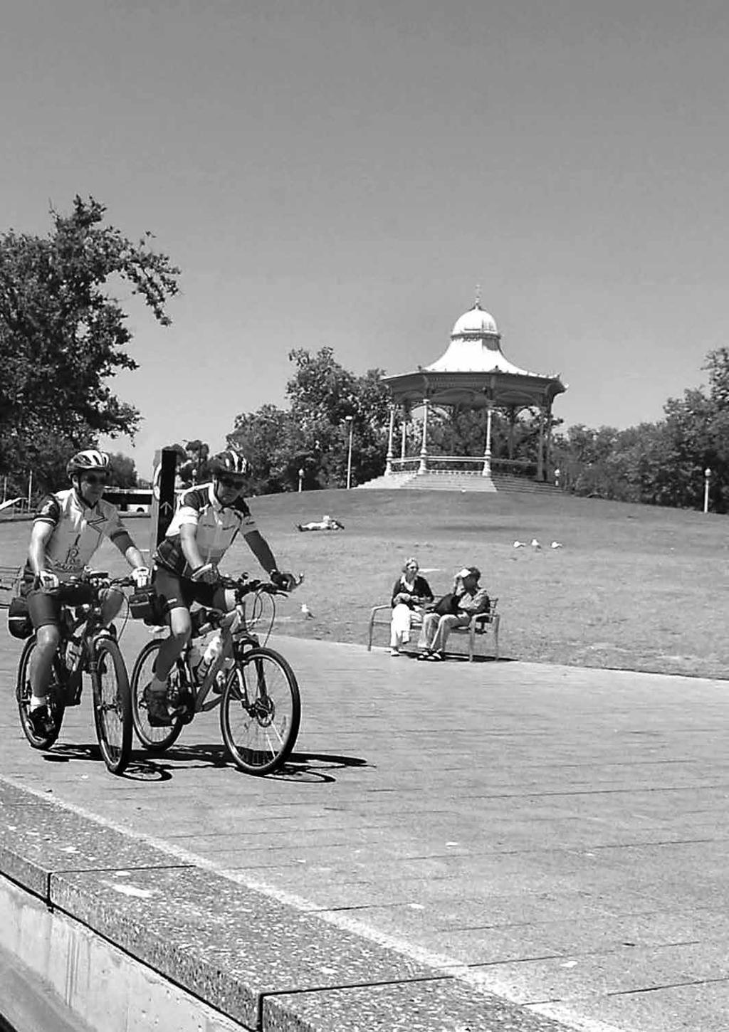
adelaide Cyclists enjoying the scenery along the River Torrens near Elder Park.
|
|
|
- Elwin Boone
- 6 years ago
- Views:
Transcription

1 adelaide Cyclists enjoying the scenery along the River Torrens near Elder Park.
2

3 16 region adelaide adelaide Free bikes are available to cycle in the city. See Listings (p136) for pick-up locations. Long-time Bicycle SA member Warwick Cooper is so passionate about getting more families involved in cycling, he developed riding group Pedalling Parents, which cycles along some of our best metropolitan rides. The rides in this section are all within the metropolitan area. Some are for the more experienced and faster riders, the coastal roads and paths are perennial favourites with weekend road riders, who flash past in a blaze of lycra-clad colour, while others are an easy meander, making them ideal for families. There is no doubt Adelaide is one of the most cycle-friendly cities in the world. Three-time track cycling Olympic medallist Brett Aitken says: Of all the cities throughout Europe and the US, Adelaide still ranks number one in my book as the most easily accessible city by bike. The bike rides on the following pages start at various locations throughout Adelaide, including schools and rail stations, then move through the suburbs, taking advantage of the many reserves and parks, as well as the local history. After all, riding a bike is not only good for your health but also permits you to grow your appreciation of Adelaide and its colourful past. The Battle of the Coral Sea rides (see p26) takes in some of the most picturesque beachside suburbs in Adelaide. Cruise down the pine tree-lined streets and enjoy the many historic sites the ride has to offer. The great views along this ride are reward themselves, but when you have completed the ride reward yourself with a relaxing coffee or ice-cream at the Grange Jetty Kiosk located right next to the Grange Jetty. If you've really worked up your appetite and are looking for something more substantial try the Grange Hotel. The atmosphere is always 'casual seaside' and it's popular with holidaymakers and locals. Maxwell s Coffee Ride (see p34) is much more than just a leisurely cruise down by the beach. As the name suggests, there is the incentive of a fantastic coffee halfway through the ride at Market on Maxwell Cafe to keep you going. Continue on your way and see the federation-style Partridge House built in 1899 and Glenelg's well-known Air Raid Shelter. Adelaide is fortunate to have a great connection of bike paths, including the Westside Bike Path (see p33), which is a popular track for cycling city workers who want a quick and safe way into work each day. So, why not get active with your family, see some of this great city and join the thousands of South Australians, as well as visitors, who take to the streets, lanes, tracks and trails of SA? Enjoy! Warwick has been involved with Pedalling Parents, which aims to get families out of the house and onto a bike, for more than 10 years. For more information, contact Bike SA on
4 ad
5 ad
6 adelaide region 19 adelaide south parklands bmx trail track easy (kurragga) beginners to advance Adelaide Parklands. This trail links the scenic western, southern and eastern parklands surrounding Adelaide's CBD. It connects to secondary paths, sports fields and biodiversity sites, and is recognisable by its ochre colour. To the west is Bonython Park where Schutzenfest is held in summer, while to the east is Rymill Park and Adelaide's Botanic Gardens. There are plans to extend the route to loop the city. Type Shared-use asphalt path. Riding time Allow 1-2 hours for time to see sights. Distance 4km. Start point South Parklands BMX Track, Unley Rd, South Parklands, or near the playground on West Tce. End point Botanic Gardens entrance, North Tce/Botanic Rd. Access and parking Free and meter street parking. Facilities Toilets, kiosk, playground, BBQ, petanque piste and BMX track in Kurrangga Park. Toilets in Rymill Park. Cost Free. What to take Water bottle, sunscreen, camera. Bonython Park Port Rd Old Adelaide Goal Glover Ave Sir Donald Bradman Dr West Tce Anzac Hwy start When to go All year round. Events and attractions Schutzenfest festival in Bonython Park (summer), Adelaide Gaol, rose display in Veale Gardens and the beautiful Japanese garden. Rymill Park hosts many major events, including the Tour Down Under in January, Adelaide Fringe in Feb-March and the Australian International 3-Day Equestrian event in November. the adelaide parklands trail Greenhill Rd North Tce Victoria Square Veale Gardens start finish South Tce Unley Rd South Parklands BMX Track Tour operators/ bike hire Bike About Mountain Bike Tours and Hire, , about.com.au; Adelaide City Bikes scheme, Bicycle SA, , Prohibited N/A. Information Adelaide City Council, adelaide.com.au; Rundle Mall Information Centre, cnr Rundle Mall and James Place, Rymill Park Botanic Rd Dequetteville Tce Wakefield Rd East Tce Fullarton Rd
7 20 region adelaide HISTORic TRAIL the artful dodger easy North Adelaide The lanes and paths of North Adelaide and the Adelaide Parklands. Type Shared-use one of the people roads and paths. associated with the foundation of SA. Cross Riding time Torrens Rd at the lights 1-2 hours, and enter the parklands depending on stops. next to the Adelaide Distance 10-15km. Aquatic Centre. Start point Follow the paved North Adelaide path east past the railway station, War Aquatic Centre. Once Memorial Drive. past, follow the path on the right so you can End point cross Barton Tce West at See above. the traffic lights. Here, you will pass Greenhill Access and Galleries, a distinguished parking private art gallery. The Parking available at building was built in North Adelaide railway 1860 and was home to station, along War a prominent family for Memorial Drive. 40 years. Head east on the footpath and turn Take the cycle into Hack St. path that heads north (parallel to railway Turn left at line). Enter Park Tce and Childers St, then cross Hawker St at the right at Fenchurch St. lights, continue on Park Turn right into Gover St Tce. Watch for 62 Park and left into Gover Tce, which is Prospect Place. Follow it to the Hall, the former home end, then find your way of George Fife Angas, to Tynte Place. Turn right at Tynte St, left at Tynte Court. Head south across the shopping centre car park roof to reach Archer St, now go right. Turn left at Walter St, left at Ward St and right into Australia Lane. The Daniel O Connell Irish Pub in Tynte St was formerly the North Adelaide Hotel. This hotel was first licensed in 1850 and was originally called the Commercial Inne. It was rebuilt in The then publican was the widow Margaret Iben who took over her husband's licence and ran it alone until The old hitching post is still there. Cross Brougham Place and the park in a south-east direction, then cross Brougham Place again and enter Brougham Court. At the southern end, go down the lane that leads to Kermode St. Turn left here, then turn right at Abbott Lane. Cross Pennington Tce, taking the southeast path through the Moreton Bay fig trees. Go left past the toilets, then Adelaide Oval in a south-west direction. Cross War Memorial Drive at the lights and go under the bridge. Take the first gravel path to your left. Cross War Memorial Drive, find the bitumen path (between Moreton Bay fig trees). Follow this north-east. To your left is Angus Gardens. Cross Frome Rd, stay on the gravel path. To your left is the King George V statue by M Lambert. Cricket is played in these parklands in summer. To your left is the Soldiers Memorial Garden and a playground. Cross Bundeys Rd. Turn right into Mackinnon Pde and left at Parker Court, right into Melbourne St. Cross the street, turn left into West Pallant St. Turn left at Stanley St,
8 adelaide region 21 right into Fuller St, left at Kingston Tce. At the Jerningham St and Kingston Tce junction, follow the path through the parklands to Glover Playground. Cross Lefevre Tce at the lights. Go west along Tynte St, then left at Margaret St Nth, go through the park. Cross Archer St, continue on Margaret St, cross Ward St, still on Margaret St. Turn right at Brougham Place. Cross O Connell St at the lights, go westward as the street becomes Palmer Place. Cross the pedestrian crossing. Veer right on Montefiore Hill, cross Jeffcott St at the lights, continuing on Montefiore Hill into Strangways Tce. There are various paths that run parallel to Strangways Tce. Ride these until you come to Mills Tce. Follow the stepped off design of Mills Tce in a northerly direction. Near the right turn at Buxton St, follow the old broken down path carefully down the escarpment, cross War Memorial Drive, then turn right to get back to North Adelaide railway station. Torrens Rd the artful dodger Hawker St North Adelaide railway station Mills Tce Mills Tce Park Tce START/finish War Memorial Dr Barton Tce Barnard St Childers St Strangways Tce Aquatic Centre Ward St City of Adelaide Golf Links Gover St FrenchchurchSt Gover Pl Tynte Pl Tynte Crt Walter St Australia Lne Margaret St Tynte St Tynte St Archer St Brougham Pl Montefiore Hill O'Connell St Lefevre Tce Brougham Pl Brougham Crt Kermode St Abbot Lne Pennington Tce Angus Gardens Adelaide Oval Robe Tce Glover Playground Frome Rd Packer Crt Melbourne St Finnis St Mackinnon Pde Fuller St West Palant St Soldiers Memorial Gardens Makinnon Pde Bundys Rd Stanley St River Torrens University of Adelaide sportsground botanic park bonython park

9 A BMX rider get some air at the jumps park.
10 adelaide region 23 south parklands bmx track easy to hard Kurrangga Park, southern Adelaide Parklands, near the corner of Greenhill and Unley rds. The South Parklands BMX Track caters for BMX and mountain bike riders of all levels with a beginner, intermediate and advanced track. The new facility is family friendly, featuring a recreation loop around the beginners and intermediate tracks, a jumps park, and seating, picnic tables and a barbecue. Type Beginner to Toilets nearby. The BMX advanced BMX track connects to the track with an adjacent Adelaide Parklands Trail jumps park. (see p19). and elbow pads, gloves. When to go All year round. Events and attractions Sports matches are regularly held in the southern parklands. Adjacent to the BMX Track is a rose display in Veale Gardens and the beautiful Japanese Garden. Prohibited N/A. Information Adelaide City Council, , com.au; Rundle Mall Information Centre, cnr Rundle Mall and James Place, Riding time Suitable for a half-day or full-day visit with the family. Distance Short loop circuits. Start point Kurrangga Park. End point See above. Cost Free. What to take Shin guards, knee Carrington St Halifax St Gilles St South Tce Tour operators/ bike hire Refer to details under Adelaide Parklands Trail (see p19). hurtle square Access and parking Meter parking and access off Unley Rd. Facilities Picnic tables, seating and barbecue area. Veale Gardens walyo yerta Park kurrangga park South Parklands BMX Track Greenhill Rd Pulteney St pityarrilla park southern parklands
11 24 region adelaide river torrens linear park trail easy Metropolitan Adelaide. Linear Park runs from the beachside suburb of Henley Beach to Athelstone in the city s north-east, following the bends and curves of the River Torrens. Designed for walkers and cyclists, the trail weaves through the city centre, passing Elder Park, Adelaide Festival Centre, Adelaide Convention Centre and Adelaide Zoo. The Linear Park trail is ideal for all fitness levels and ages. Type Multi-use you start. From the city, Linear Park path. you can ride to Henley Beach or Athelstone. Riding time 1-6 hours (2 hours Access and from the city to the parking Street coast or hills, 4 hours and off-street parking is return). available along the Distance 37km (Henley length of Linear Park. Beach to Athelstone Popular parking and one-way). access is from Victoria Drive and War Memorial Start point Drive, off King William Multiple points St, city. Parking is also to begin and finish the available on The trail. However, the most Esplanade adjacent to popular starting points Seaview Bridge, Henley are at Henley Beach/ Beach; Felixstow West Beach, Elder Park, Reserve off Riverside city (bike hire available) Drive, Felixstow; River and at Athelstone. Torrens Linear Reserve, Gorge Rd, Athelstone. End point Multiple points Facilities Lawned to finish the trail picnic and depending on where barbecue areas, toilets and playgrounds are located along Linear Park. At the time of writing, a new signage system was being introduced to improve navigation for each section of Linear Park. Cost Free. What to take Sunscreen, sunglasses, water bottle, camera, picnic provisions. When to go All year round. Events and attractions Events are regularly held at Elder Park, including Carols by Candlelight (December), Tasting Australia (May), Symphony Under the Stars and the Adelaide Festival (March). The sportsgrounds along War Memorial Drive host the tennis in summer. The Henley Food Festival is held in May. Glenelg hosts the City to Bay Fun Run (September), beach volleyball competitions in summer, Glenelg market in Moseley Square in summer, Bay Sheffield athletics carnival (December). Caution Linear Park is a very popular recreational spot with pedestrians and consideration is required when using the park path. Tour operators/ bike hire Linear Park Bike Hire, Elder Park, city, ; Bike About Mountain Bike Tours and Hire, , Prohibited Unleashed dogs are restricted in some parts of the park. Call local councils such as Tea Tree Gully for details. Information Trails SA,

12 adelaide region 25 river torrens linear Park trail Port Rd ferryden park South Rd sefton park Main North Rd collinswood hillcrest North East Rd paradise START/finish athelstone START/ FINISH henley beach west beach START/FINISH croydon payneham START north adelaide st morris Adelaide Zoo underdale CITY marryatville South Tce Convention Centre Adelaide Festival Centre magill north auldana Linear Park by the River Torrens, city, is a popular family spot.
13 26 region adelaide HISTORic TRAIL battle of the coral sea easy Grange, Henley Beach, Henley Beach South, Fulham, Fulham Gardens, Seaton. From the sand hills and swamps to suburbs. Type Road Sturt Ave, then right into cycling. Old Port Office Place. Go down the laneway to Riding time 1-2 Military Rd, then go left. hours depending Turn left at Jetty St and on stops. Distance travel east. Both Grange 10-15km. Primary School and Captain Sturt s cottage Start point are to your right. Grange Railway Station (near the Go past the tennis intersection of Military courts, then turn Rd and Terminus St). right on to the Grange Lakes path. Follow this, End point cross Beach St to enter See above. Kirkcaldy Park. Continue on the path. Turn right Access and and walk along the parking Cyclists footpath when you can get the Grange train reach Grange Rd at Kirkcaldy Ave. Cross Grange line from the city to start this ride. Parking is Rd and enter Wright St. available at the Grange train station. Turn left across the parkland into UBD Reference Chambers St and keep UBD 115 N2 going straight. Cross Marlborough St and From Terminus St then North St and keep ride right a short going along Chambers way to Charles Sturt St which ends at the Ave. Go right at Charles Henley/Grange main oval. Follow the track south-west across the park to get to Raymond St. Turn left into White St, then left into Atkin St and cross Cudmore Tce into Griffiths St via The Cycle connector path. Turn right at North St, cross at the school crossing (which is on your right). Keep riding southwards. Turn left into Riverside Drive, then right at Everest St and continue south until Hughes Ave, where you turn right. Turn left into Cudmore Tce, cross Henley Beach Rd at the lights (on your left). Keep going along Cudmore Tce, then go right into HMAS Australia Rd and turn left into Burford Rd. Turn left into Lexington Rd, and left at Kincaid Rd. Follow it as it passes a park. It will re-enter Lexington Rd. Go left to get to Burnley St, where you turn left and then right at Coral Sea Rd. Ride quite a way along Coral Sea Rd, following the park. Turn right into Halsey Rd, left at Dewey St. Cross busy Tapleys Hill Rd at the lights and turn right. Proceed to Davis Bridge and turn left into Linear Park along the River Torrens and ride in an easterly direction. Pass Kidman Bridge (Henley Beach Rd), turn left at Riverway (at the Breakout Creek rehabilitation program sign). Follow Riverway until you see a footpath on your left heading south. Turn into Weetunga St. Here, to your left, is historic Weetunga House. Proceed west along Weetunga St to Tapleys Hill Rd. Cross the road and adjacent park into Louise Ave then turn right into Tatura Cres and follow the crescent to the left (becomes Madeleine Cres). Veer left, then turn left into Stanford Cres, right into Rivett Ave and left into
14 adelaide region 27 the reserve and cross it in a northerly direction. Go right into Cheadle St, left into Fisher Tce and follow it to the reserve on your right. Cross it into Sunningdale Rd and turn left. Turn right into Hothouse Rd, left at Marlborough St, then right into Marlborough Cres and follow this straight line north as it becomes Ascot Ct, then Porter Cres, and then Westminster Ave. Turn right at York Ave. Continue right along York Ave, left into Shaftesbury Ave and cross Grange Rd. Go left and ride a little way to Corio Ave, go left here. Turn left into Willcocks Ave and cross Willcocks Ave Reserve on your right. Go north on McMurray Ave. Cross the reserve on your left as the street angles rightwards and changes name to Shandon Ave. Go down Traphen Ave, right at Lambros Ave, START/finish Grange Railway Charles Sturt Terminus St Station Ave Old Post Office Pl Jetty St Military Rd Napier Dr Beach St Kirkcaldy Ave Grange Rd grange Seaview Rd henley beach Esplande henley beach SOUTH North St White St WrightSt Chambers St Burford Rd FrederickRd TandanyaAve Westmoreland Rd HMAS Australia Rd then left into Meakin Tce. Cross Frederick St, go down Westmoorland Rd via the cycle pathway on the western side of Frederick St. Turn right into Willochra Ave, left Charlotte Cr TraphenSt WillcocksAve seaton Westminster Ave Murray St Bolingbroke Ave Buckingham Ave Marlborough St Raymond St Atkin St Hughes Ave Kincaid Rd HolthouseRd Everest St Lexington Rd Meakins Tce Lambros YorkAve Cheadle St Rivett Ave Riverside Dr Burnley St Shandon Ave Corio Ave Porter Cr Ascot Ct Fisher Tce River Torrens outlet McMurray Ave ShaftesburyAve fulham gardens Tapleys Hill Rd SunningdaleRd Madeline Cr Henley Beach Rd fulham at Wandilla St. As the road forks at the reserve veer right into Tandanya Ave, right at Charlotte Ct, left at Jetty St. Cross it and follow the path on the left-hand side until you reach the railway line. Turn left and cross Tatura Cr Louise Ave Coral Sea Rd Halsey Rd Stanford Cr Dewey St the park to get to Terminus St and back to Grange train station.

15 The Coastal Way at Semaphore is an ideal ride for families.
16 adelaide region 29 adelaide - glenelg - outer harbor ride easy Adelaide city to the coastline. This ride is popular with families because of the wide roads and flat trails. The ride passes some of Adelaide's best beachside attractions, such as Glenelg where you can cool down on The Beachhouse's waterslide or stop at Henley Square for a drink at Estia, Stella or Bacchus Bar. Type Road cycling Access and (coastal). parking Road access is from West Tce Riding time (street parking here). 2-3 hours. At Glenelg: park near Distance 27.5km Colley Reserve. one-way/55km return. Facilities Cafes Start point and toilets at Elder Park, Glenelg, Henley Beach, city, via Linear Park (see Semaphore, Largs Bay p24) or Anzac Hwy or and North Haven Glenelg are popular Marina. start points. Other route options from the city Cost are via Port Rd to Port Free. Adelaide and on to the Coastal Way. Or, from What to take the city via Sir Donald Sunscreen, water Bradman Drive to West bottle, sunglasses, Beach and on to the camera. Coastal Way. When to go End point All year round. Outer Harbor train station. Cycle back or Events and get the Outer Harbor attractions train to the city. Semaphore Kite Festival (March), Henley Food Festival (May), Bay Sheffield at Glenelg (December), Semaphore Summer Carnival and Greek Festival (January). Cycling time trials and triathalons on Sundays. Tour operators/ bike hire Linear Park Bike Hire, Elder finish outer Harbor west lakes Torrens Island Port River Exp Port Rd Findon Adelaide Airport Colley Reserve glenelg START Park, Beach Hire SA, Moseley Square, Glenelg, Information Glenelg Visitor Information Centre, glenelg to outer harbor South Rd Henley beach south START west Sir Donald Bradman Dr beach Anzac Highway Port Wakefield Rd START parkside
17 30 region adelaide HISTORIC TRAIL maud's grave moderate Tusmore, Hazelwood Park, Burnside, Stonyfell, Erindale, Leabrook. A journey between First and Second Creeks, including a botanic garden and a suburban forest remnant. Type Multi-use are to your left. Turn Linear Park path. into Sidney Place and right into Howard Tce Riding time 1-2 where you will see hours depending Hazelwood Park on stops. (playground, BBQ, Distance 10-15km. toilets). Turn left into Davenport Tce, right Start point into Hazelwood Ave. Burnside Primary School, 11 High St, Turn right into Burnside. Knightsbridge Rd and left at Rodger Ave, End point then left into Rochester See above. St. Cross Tusmore Ave and go down Newcastle Access and St until you get to parking Tusmore Park (play- Street parking outside ground, BBQ, shade Burnside Primary. cloth, toilets, tennis courts and First Creek). UBD reference In 1848, this area was UBD 119 N15 laid out as the village of Knightsbridge (between Turn left into First and Second Burnside Court creeks). It was named and continue into after the London William St. Turn left into suburb, and was never Young St and cross developed because of Glynburn Rd at the the creeks, trees and pedestrian lights, which rough ground. Cross Lockwood Rd and look to your left for the entrance to a path that follows Second Creek. Follow it and ensure that you keep right. Here on your right you will see the grave of the child Maud White who died in Along this section of the creek were the wattle and daub huts of a shifting and anonymous population of colonials trying to establish a permanent settlement. Turn left into Nilpinna St, then left at High St and cross Hallett Rd. Be careful of traffic as you cross. You will notice a laneway to your left called Andrews Walk. Follow this until you reach the end and turn right to enter Michael Perry Reserve. When you get to this point you need to decide which way you want to go back to the start. There are two choices. Route A: The thrill of the downhill Ride to the top of the creek and cross the ford. Warning: do not do this if the creek is flowing deeply or fast. Follow the downhill track on the south side of the creek until you see a road, cross it and continue. When you reach the Andrews Walk laneway that you rode up earlier, cross over it and follow the creek until you reach Heatherbank Tce where you turn left. Turn right into Hallett Rd, left into Newland Rd. Turn right into Debney Drive, then left into Undelcarra Rd. To your right is a laneway. Take this and follow the creek to Lockwood Rd. Turn left at Lockwood Rd, turn right into High St and head back to where you started at Burnside Primary School. Route B: Historic route Return to the entrance of Michael Perry Reserve and head
18 adelaide region 31 east into Kurrajong Ave. This is a steep hill. To your right at the junction of Waratah Way is the entrance to the gothic Clifton Manor built by George Deane Sismey in In 1872, the battlements were added by the new owner, lawyer Nathaniel Knox. He also inscribed his coat of arms 'Caesar or nothing'. In 1932, the manor was bought by Dr Michael Schneider who turned the estate and its landscaped gardens into a native animal sanctuary. The house is rumoured to be haunted by the ghost of Mrs Sismey. Now turn left into Grevillea Cres and right into Karri St. Turn left into Heatherbank Tce and right into Wurinya Ave. Cross Marble Tce, ride across the sprawling Ferguson Conservation Park and turn left into Stonyfell Rd. Cross Hallett Rd at the pedestrian crossing to your left. Head west down Statenborough St, which is to your right. Turn left into Wallace St and right into Cowan St, then left into Torrens Ave. Cross Newland Park and turn left into Newland Rd. Turn right into Debney Drive and left into Undelcarra Rd. To your right, you will see a laneway. Take this and follow the creek to Lockwood Rd. Turn left into Lockwood Rd and turn right into High St and head back to where you started at Burnside Primary School. Tusmore Ave Newcastle St Rochester St Tusmore Park Kensington Rd Statenborough St Hazlewood Ave Rodger Ave fast facts Hazelwood Park 1 was originally 'Hazelwood Farm' owned by Francis Clark in One pear tree is the only survivor of long-gone orchards. The gum trees are more than 250 years old. Ferguson Park is 3 the 8ha bequest Glynburn Rd Knightsbridge Rd Davenport Tce Hazelwood Park maud's grave Young St Burnside Primary School William St High St Lockwood Rd START/finish Hallett Rd of Ellie Ferguson. In 1976, it was proclaimed a conservation park because of its unique collection of native flora, including 15 rare species. The park also attracts koalas and 40 species of native birds. It is a place where we can see what SA was like before Stonyfell Rd Ferguson Park Marble Tce Wurinya Ave Heatherbank Tce Michael Perry Res

19 A cycling team checks out the Westside Bike Path.
20 adelaide region 33 westside south parkland bike path bmx track easy (kurragga) beginners to advance South-western Adelaide. The Westside Bike Path follows the route of the old Holdfast Bay railway. This mostly tree-lined and off-road trail winds through the industrial and commercial south-western suburbs from West End and Richmond before emerging at Novar Gardens, near Glenelg. This route is popular as a commuter trail by cyclists to ride into work in the city or for those wanting a safe ride to the beach. Type Richmond Oval, along Shared-used Deacon Ave or Fleet St, sealed path. Richmond. Riding time Facilities 30 minutes Toilets, one-way. One-hour playground, tennis return trip (if heading to courts, picnic tables at Glenelg). Distance 7km. Weigall Oval, cnr Oval Tce and James St, Start point Cnr Plympton. BBQ, tennis Deacon Ave and and basketball courts, South Rd, Mile End, playground at Camden where the path starts. Recreation Ground, Novar Gardens. End point Camden Cost Recreation Ground, Free. Anzac Hwy, Novar Gardens. You can cross What to take Anzac Hwy and follow Sunscreen, water the tram line to Glenelg. bottle, sunglasses, camera. Access and parking When to go Street parking near All year round. Events and attractions Recreation reserves along the trail are ideal for family picnics. Glenelg's Jetty Rd is a popular shopping strip. Head there for the Glenelg Christmas Pageant, Glenelg market in summer, New Year's Eve festivities, The Beachhouse fun park, Holdfast Shores eateries and the beach. Westside bike path start Deacon Ave Richmond Ave adelaide airport Morphett Rd Tour operators/ bike hire Adelaide City Bikes, 111 Franklin St, city, , asn.au. Prohibited N/A. Information Visit www. southaustraliantrails.com. Bicycle SA, , Marion Rd Mooringe Ave Cross Rd Camden Oval edwardstown Anzac Hwy finish London Rd keswick terminal South Rd goodwood Glenelg Tram
21 34 region adelaide HISTORIC TRAIL maxwell coffee ride easy Camden Park, Glenelg, Glenelg East, Glengowrie. Scenic ride of established beachside suburbs that ends with a good coffee on Maxwell Tce, Glengowrie, at a favourite haunt of Adelaide cyclists. Type Road motorists as you cross. cycling. Follow the footpath. Riding Time 1-2 The track turns hours depending left between the on stops. Distance 12km. soccer pitch and the football oval. Follow the Start point The track left towards Anzac playground at the Hwy. Turn right at Anzac corner of Colin St and Hwy and follow the trail Creslin Tce, Camden (along the footpath) Park, on the Westside until you see the Bike Path. pedestrian island. Cross Anzac Hwy here, End point watching out for traffic. See above. Go right along the shared footpath Access and (pedestrian and bike). parking Street Turn left into Grove St, parking along Westside then right into Augusta Bikeway. St. Cross Merriton St and dogleg left and UBD reference then right at Miller St, 129 A15 so that you continue along Augusta St. Proceed west along the bike Turn right into trail. Cross Morphett Rd Sixth Ave and there are no traffic enter Smedley Reserve lights here so beware of (toilets) from the Anzac Hwy end. It is on your right. To resume the ride, return via Sixth Ave to Augusta St and continue west along Augusta St. Pause and play at the Sandison Reserve between Fourth and Third Ave. Turn left into Third Ave. Turn right into Dunbar Terrace and ride until you get to Brighton Rd. Turn left and cross the tramline at the pedestrian crossing next to Brighton Rd. This is a very busy road, so cross Brighton Rd at the traffic lights. Turn left on reaching the footpath and walk a few metres to Newman s Lane. Turn right into the lane and resume cycling. Turn left into Marion St and then right into High St. Just after you enter High St, look to your left for a laneway. Follow the lane south into Penzance St. To your right there is a gate to enter the grounds of the historic Partridge House. Have a look around the grounds of Partridge House (playground, toilet). Then get back on to Penzance St travelling right. Turn left into Pier St heading toward Brighton Rd. Cross Brighton Rd at the traffic lights. Proceed along the footpath. Turn left into Glenelg Primary School. Cross the playground in a north-east direction and you will come to a laneway at the southern boundary of Glenelg Oval. Turn left into Williams Ave, then left again into Rugless Tce. On your left is the Glenelg Air Raid Shelter. Go east along Rugless Tce. Follow the bend of the road rightwards into Short St, turn left into St Peters St. Cross Wyatt St and stop to check out Da Costa Reserve. Return to Wyatt St and ride south until you get to Wilson
22 adelaide region 35 Tce. Turn left here and continue along it. Wilson Tce becomes Frederick St. Keep going straight until Gillespie St where you turn right. Cross Cliff St into McGilp Ave. Turn left into Stanley St. You can stop for a rest at the Stanley St Reserve. Cross the reserve, past the tennis courts, and take the dirt path that leads into Rosslyn St. Continue south along Rosslyn St until you get to Baker St, turn right here, then take a quick left into Hampden Link. Turn left into Whiteleaf Cres, right into Giles Way and left into Penn Corner. Turn left into Wycombe Way and left again at Hazelmere Rd and follow it north as it becomes Filmer Ave. Continue north (there s a slight left), it now becomes Joan Ave. Veer left into Beadnall Tce. On your right at the intersection of Butler Cres is the Glengowrie Penzance St Marion St Brighton Rd Third Ave Anzac Hwy Dunbar Tce Methodist Church. Turn right into the Breakout Creek Reserve, which is a linear park on the western side of the church. Ride along the reserve until you reach Maxwell Tce. Near Maxwell Tce there is a playground on your maxwell coffee ride Augusta St glenelg East Wyatt Tce Partridge House Air Raid Shelter Sixth Ave Merriton St St Peters St Wilson Tce Diagonal Rd Stanley St Reserve Grove St Maxwell Tce Rosslyn St Filmer Ave Hazelmere Rd right. To your left on Maxwell Tce is Market on Maxwell Cafe where you can rest and relax before the final journey. Cross the tramline at the roundabout junction of Buttrose St and Maxwell Tce. Turn right into Dunbar Tce and then left into Grove Morphett St Morphettville Racecourse morphettville Sturt River Colin St Creslin Tce START/finish Creslin Tce Anzac Hwy Bray St Oaklands Rd St. Turn right on to the shared pathway (bike/ footpath) at Anzac Hwy. Cross the road at the pedestrian island (this is where you crossed Anzac Hwy earlier in the ride). After crossing, turn right on to the shared pathway, then follow the trail back to the starting point. Hendre St

23 Riding on the Southern Veloway.
24 adelaide region 37 southern parkland veloway bmx moderate track (kurragga) beginners to advance Southern Adelaide (Darlington to Willunga). This purpose-built veloway runs alongside the Southern Expressway. From here you'll see spectacular views of the Adelaide coastline and plains as you traverse challenging inclines. From Reynella it continues as a shared path southward towards the historic village of Old Noarlunga. From here you can follow a rail trail to quaint Willunga, the home of the Almond Blossom Festival and Willunga Farmers Market. Type Kaurna Cultural Centre, Linear cycle path. Bedford Park (UBD J6 Map 153); Railway Rd, Riding time Onkaparinga Recreation 2 hours return. Park, Seaview Meadows Distance 7km (veloway (UBD Q11 Map 185). runs from Marion Rd, Sturt, to Panalatinga Facilities underpass), then it is a Toilets at the shared use track to the Kaurna Cultural Centre. end of the Expressway. The ride is 22km when Cost linked with Coast to Free. Vines Trail (see p82). What to take Start point Sunscreen, water Cnr of Marion and bottle, sunglasses, Main South rds, Sturt. camera, snacks. January. The veloway connects to the Coast to Vines Trail (see p82). Prohibited From Darlington to Reynella - bikes only (animals and pedestrians prohibited. From Reynella to Huntfield Heights - shared use, animals allowed. SouthernVeloway to Willunga lonsdale Tour operators/ bike hire Bike About Mountain Bike Tours and Hire, , www. bikeabout.com.au. Information Trails SA, www. southaustraliantrails. com. Bicycle SA, , asn.au. sheidow park Anzac Hwy Marion Rd South Rd sturt START End point High St, Willunga. Access and parking Warriparinga Living When to go All year round. Events and attractions The Tour Down Under in Onkaparinga River Recreation Park old noarlunga willunga finish
25 38 region adelaide coastal way moderate Adelaide coastline. The Coastal Way concept is to create a linear park incorporating a walking/cycling path along Adelaide's metropolitan coastline from Sellicks Beach in the south to North Haven. It's currently still under construction with about half the route completed. There are long sections of continuous paths from Somerton Park to the River Torrens and from Semaphore South to North Haven. The other sections can be linked using existing roads. A popular section is from Glenelg to Outer Harbor. When to go All year round. Events and attractions Fort Glanville, Semaphore (regular open days). Jetties at Glenelg, Henley Beach, Grange, Semaphore and Largs Bay. Semaphore Music Festival (October). Tour operators/ bike hire Beach Hire SA, Glenelg, Information Glenelg Visitor Information Centre Bicycle SA, , asn.au. Type Shared-use. Riding time 2-3 hours recommended. Distance 17km one-way. Start point Moseley Square or Colley Reserve, Glenelg. End point Outer Harbor train station. Access and parking Street parking near Colley Reserve, Glenelg; Henley Square; Signal Station Reserve, Sema- phore; Largs Bay Sailing Club, Largs Bay; Jaycee Park, North Haven. Facilities Kiosks and toilets are right along the trail as are interpretive signage and rest spots. There are boardwalks over sand dunes. The Coastal Way connects numerous coastal parks, reserves, beach access and links to the River Torrens Linear Park at Henley Beach. Cost Free. What to take Sunscreen, water, sunglasses, camera, snacks, bathers, towel. Coastal way Outer Harbor finish North Haven Largs Bay Semaphore Grange Henley Beach West Beach Glenelg Brighton Seacliff Hallett Cove O'Sullivan Beach Christies Beach Port Noarlunga Seaford Moana Maslins Beach Port Willunga Aldinga Beach Sellicks Beach START

26 adelaide region 39 field river trail and environs moderate (a few hills) Southern Adelaide (Old Reynella, Reynella East, Happy Valley and Woodcroft). This trail runs alongside the Panalatinga Creek, past giant gums and reserves including Balee Road Reserve, Horndale Park and Tangari Regional Park, which is home to one of the best remnants of Grey Box grassy woodland in Adelaide and is teeming with native animals, birds and plants. Stop for a cake at Old Reynella Town Bakery or a drink at the Crown Inn Hotel. Type Sealed paths and a few unsealed tracks. Ride Time 1½-1¾ hours. Distance 17.5 km. Start point The Panalatinga Creek sign, eastern side of Old South Rd, Old Reynella, next to Crown Inn Hotel. Follow BikeDirect signs past Horndale Park, Tangari Regional Park and Woodcroft Park. End point Loop trail. Return to Old Reynella via the Morphett Vale/Old Reynella section of the Coast to Vines Rail Trail (see Information). Access and parking Old Town Reynella Shopping Centre car park. Facilities Toilets at Old Town Reynella Shopping sheidow park START/finish Southern Expressway Bikeway Main South Rd old reynella Bains Rd Panalatinga Rd morphett vale Centre and near Pimpala School. Annie s Cafe, Old Reynella Town Bakery, Old Town Cafe and Crown Inn Hotel for refreshments. Cost Free. What to take Bike hybrid or MTB preferred. Camera. When to go All year round. Events and attractions John Reynell Heritage Park, Kenihans Rd reynella east Reynell Rd Pimpala Rd Byards Rd Reynella Horse Changing Station, John Reynell Memorial Site, Stony Hill Vineyard, Balee Road Reserve, Horndale Park, Easton Barn, Mt Hurtle Winery. Tour operators/ bike hire Beach Hire SA, Glenelg, Prohibited N/A Information Rail Trails Australia, trails.org.au. Chandlers Hill Rd Field River Trail and Environs
FREE CITY SERVICES. Detailed route information available on the metromate app and the Adelaide Metro website 98A 98C NORTH ADELAIDE 99A 99C ADELAIDE
 EXPLORE FREE SERVICES The free City Connector bus service runs on two loops an inner city loop and an extended loop around providing a link to popular attractions, shopping, dining and destinations. The
USING THE SERVICE 98C 98A NORTH ADELAIDE 97A 99A 99C ADELAIDE CBD. Tram
 EXPLORE BY BUS NEW Temporary service linking the old RAH with the new RAH Effective 17 December 2017 USING THE SERVICE The free City Connector bus service runs on two loops an inner city loop and an extended
FREE PUBLIC TRANSPORT MIDNIGHT TO DAWN *
 FREE PUBLIC TRANSPORT MIDNIGHT TO DAWN * 1300 311 108 adelaidemetro.com.au @AdelaideMetroSA facebook.com/dptisa *Services are free from12.01am 1 January 2015, with normal Metro Fare services resuming between
ADELAIDE PARK LANDS VISITOR RESEARCH STUDY 2014
 ADELAIDE PARK LANDS VISITOR RESEARCH STUDY 2014 Acknowledgement to Country Adelaide City Council acknowledges the traditional Country of the Kaurna People of the Adelaide Plains and pays respect to Elders
Adelaide trams. Route descriptions. Useful information. FREE tram travel:
 trams Effective 29 July 2018 W This timetable covers tram services linking: Glenelg N S E Useful information Download metromate Find your next service in real time. Register for disruption updates sent
H22 H23 H24 H32 N22 H22 H23 H24 H32 N22 H22 H23 H24 H32 N22. Route descriptions. Useful information
 W Lockleys Norwood Wattle Park Auldana to Wattle Park to Auldana to Auldana N S E Useful information Visit adelaidemetro.com.au Get real time journey planning, fare information, disruption alerts & more
Route descriptions. Useful information
 W N E Useful information Route descriptions Effective 17 December 2017 This timetable covers bus services linking: Colley Terrace Edwardstown Mitcham Square Unley Unley S Download metromate Find your next
Adelaide Park lands VISITOR RESEARCH STUDY 2014
 Adelaide Park lands VISITOR RESEARCH STUDY 2014 Acknowledgement to Country Adelaide City Council acknowledges the traditional Country of the Kaurna People of the Adelaide Plains and pays respect to Elders
Glenelg tram. Route descriptions. Useful information. FREE travel between:
 Glenelg tram Effective 22 January 2018 W This timetable covers tram services linking: Glenelg N S E Useful information Download metromate Find your next service in real time. Register for disruption updates
ADELAIDE METRO TRAINS & TRAMS
 ADELAIDE METRO TRAINS & TRAMS SM1 ADELAIDE - GAWLER CENTRAL BG. Diesel Multiple Units Double track Adelaide-Gawler. Single Gawler-Gawler Central. SG line parallel North Adelaide-Salisbury. Km Ht Open Samples
AO1 Greenwith to Adelaide Oval via O-Bahn all stops to Klemzig Interchange then express
 AO1 Greenwith to via O-Bahn all stops to Klemzig then Golden Grove Road 80 The Grove Way 62A Golden Grove Road 50 Tea Tree Plaza D Paradise B Klemzig A King William Adelaide Oval AO1 4.00 4.12 4.17 4.25
Adelaide Oval Footy Express interchange map
 Footy Express interchange map Pl Pennington Tce The Memorial Hospital Legend North University Oval Rd Rd AOX1 Footy Express bus stop Train line & station Tram line & stop Walking route Montefiore Rd Hospital
SA Median House Prices March Quarter 2018
 SA Median House Prices March Quarter 2018 Brought to you by... March Quarter 2018 SUBURB ABERFOYLE PARK 33 400,000 35 465,500 16.38% ADELAIDE 6 673,750 5 861,000 27.79% ALBERT PARK 6 387,500 7 429,000
SA Median House Prices June Quarter 2018
 SA Median House Prices June Quarter 2018 Brought to you by... June Quarter 2018 SUBURB ABERFOYLE PARK 41 448,500 32 430,000-4.12% ADELAIDE 6 900,000 5 696,000-22.67% ALBERT PARK 10 426,000 6 420,000-1.41%
Seaford & Tonsley. Route descriptions. Useful information. Ticket vending machines on trains. Bikes travel free on trains
 & Effective 23 July 2018 W This timetable covers train services linking: N S E Useful information Download metromate Find your next service in real time. Register for disruption updates sent direct to
SA Median House Values June Quarter 2016
 SA Median House Values June Quarter 2016 Brought to you by... June Quarter 2016 SUBURB ABERFOYLE PARK 45 436,500 37 380,500-12.83% ALBERT PARK 8 400,000 12 467,000 16.75% ALBERTON 8 379,000 10 453,000
Serviced suburbs SA SA SA SA SA SA SA SA SA SA SA SA SA SA SA SA SA SA SA SA SA SA SA SA SA SA SA SA SA SA SA SA SA SA SA SA SA SA SA SA SA SA SA SA
 Serviced suburbs 5000 ADELAIDE 5000 CITY WEST CAMPUS 5000 PARLIAMENT HOUSE 5000 RUNDLE MALL 5005 ADELAIDE UNIVERSITY 5005 THE UNIVERSITY OF ADELAIDE 5005 UNIVERSITY OF ADELAIDE 5006 NORTH ADELAIDE 5007
The Advertiser Food Guide Retailers List PROPRIETOR ADDRESS 1 ADDRESS 2 ADDRESS 3 POST CODE ANGASTON NEWSAGENCY NP 37 MURRAY ST ANGASTON 5353
 The Advertiser Food Guide 2014 - Retailers List PROPRIETOR ADDRESS 1 ADDRESS 2 ADDRESS 3 POST CODE ANGASTON NEWSAGENCY NP 37 MURRAY ST ANGASTON 5353 CLARE NEWSAGENCY NP 263 MAIN NORTH RD CLARE 5453 GOOLWA
Adelaide BP On The Run Corner West Torrens Road & Currie Street Adelaide. BP West Terrace On the Run Cnr West Terrace and Currie Street Adelaide
 South Australia Adelaide BP On The Run Corner West Torrens Road & Currie Street Adelaide (S) Adelaide Branch 77 Grenfell Street Adelaide P Bank Street 4/136 North Terrace (in Bank Street) Adelaide BP West
Route descriptions. Useful information. Henley Beach to city
 Henley Beach Fulham Gardens Underdale W to city N S E Useful information Visit adelaidemetro.com.au Get real time journey planning, fare information, disruption alerts & more Download metromate Find your
SA Median House Prices
 SA Median House Prices December Quarter 2013 Brought to you by... October December 2013 SUBURB ABERFOYLE PARK 47 401,800 45 393,500-2.07% ADELAIDE 3 520,000 6 625,000 20.19% ALBERT PARK 5 403,500 12 385,000-4.58%
Recreation Facilities Central Area
 Central Area Bains Road Thaxted Park Noarlunga Leisure Centre NOARLUNGA CENTRE Beach Road HACKHAM WEST Main South Road Hackham Sports & Community Centre ONKAPARINGA HILLS Penneys Hill Road NOARLUNGA DOWNS
H30 X N30 H30 X N30 H30 X30 N30. Route descriptions. Useful information
 Fulham Torrensville W N S E Useful information Visit adelaidemetro.com.au Get real time journey planning, fare information, disruption alerts & more Download metromate Find your next service in real time.
Adelaide. Top 5. Botanic Gardens. Art Gallery of South Australia. South Australian Museum. Migration Museum. Tandanya Arts Centre
 Photo: ymgerman/shutterstock.com Adelaide Adelaide is a new city in an old land, founded as a British colony in 1836 and now being the capital of South Australia. Today, its rich mix of diverse cultures
J1 J J1X J1, J3, 163, 164. Route descriptions. Useful information
 Route:,,, Effective 17 December 2017 Destination: to city Also shows A & H to city West Beach to city to city W This timetable covers bus services linking: West Beach Shopping Centre West Beach Rio Vista
ROLLOUT GRASS PORTFOLIO
 ABN 31 114 919 470 480 Cross Road, Glandore SA 5037 P: (08)8293 8648 F: (08)8297 8851 E: info@rolloutgrass.com.au ROLLOUT GRASS PORTFOLIO Bowling Clubs DryMax Pro Golf Green Installation Babinda Bowling
Route descriptions. Useful information
 Mansfield Park Brompton W Mansfield Park to city to city N S E Useful information Visit adelaidemetro.com.au Get real time journey planning, fare information, disruption alerts & more Download metromate
Bus Services.
 2019 Bus Services www.loreto.sa.edu.au oreto College offers five dedicated bus routes connecting students from north, east, south and west of, providing greater service and convenience to our students.
Re-integrate the River Torrens
 1 Re-integrate the River Torrens The river is a landmark of Adelaide and is fortunate to have a wide selection of public spaces on its banks. The River Torrens is a special part of Adelaide, which needs
B10 B12 B10, B12 B10 B12. Route descriptions. Useful information
 , Effective 7 December 207 Route: W This timetable covers bus services linking: Fulham Gardens Currie Maylands Destination: to via city Also shows C to city Bus services: to See back cover for route descriptions
International Student Centre. Living in Adelaide
 International Student Centre Living in Adelaide Overview About Adelaide Things to do Places to go Climate Transport University of Adelaide 2 About Adelaide University of Adelaide 3 About Adelaide Founded
Route descriptions. Useful information. City to Glen Osmond
 Beaumont Glen Osmond Norwood City W City to Glen Osmond via Norwood Glen Osmond to city Beaumont to city N S E Useful information Visit adelaidemetro.com.au Get real time journey planning, fare information,
248F. Route descriptions. Useful information. Visit adelaidemetro.com.au Get real time journey planning, fare information, disruption alerts & more
 Hove Warradale ville Kurralta Keswick & to city Hove to city W & Warradale to city N S E Useful information Visit adelaidemetro.com.au Get real time journey planning, fare information, disruption alerts
The heart of city living
 The heart of city living The heart of city living The heart of city living Every city has a heartbeat, a rhythm that creates an energy, a vibrancy that draws people to explore its streets and laneways.
271, 273. Route descriptions. Useful information. Tea Tree Plaza Interchange
 , W N E Useful information Route descriptions Route: Effective 9 April 018 This timetable covers bus services linking: Hope Valley Reservoir Windsor Gardens Walkerville City Currie Destination: to city
W90 W91 W90, W91 W90 W91. Route descriptions. Useful information. Marion Centre
 , Effective 4 March 017 This timetable covers bus services linking: St Marys Cumberland Grenfell W N S E Useful information Website adelaidemetro.com.au on-line journey planner timetables on your mobile
Adelaide to Hawker. via Clare, Orroroo and Carrieton. Intermediate Distances These distances provide for some localised perspective of scale.
 Adelaide to Hawker via Clare, Orroroo and Carrieton HAWKER The RAA maintains some 300 strip maps covering all major routes of Australia. They are available from RAA Offices and are free to members. Strip
MURRAY PRINCESS 7 NIGHT MANNUM TO RENMARK NYE CRUISE ITINERARY
 MURRAY PRINCESS 7 NIGHT MANNUM TO RENMARK NYE CRUISE ITINERARY The Mannum to Renmark New Year s Eve Cruise departs Mary Ann Reserve, Mannum at 4.30pm on Friday 27th December, 2019. The cruise arrives in
241, 245, 248F. Route descriptions. Useful information. Website adelaidemetro.com.au on-line journey planner timetables on your mobile
 Route:,, Effective 10 September 17 This timetable covers bus services linking: Hove Dunrobin ville Kurralta Keswick Everard Avenue Destination: W & to city Also shows A Hove to city & to city Also shows
F N F 203F 209F N202. Route descriptions. Useful information
 Ingle Farm Northfield Sefton Park Walkerville W Ingle Farm to city & Ingle Farm to city & Ingle Farm to city Ingle Farm to city N S E Useful information Visit adelaidemetro.com.au Get real time journey
Suburb flyover report
 Suburb flyover report GLENELG EAST (HOUSE) PREPARED BY: YOUR PROPERTY EXPERT, RAY WHITE ADELAIDE GLENELG EAST Suburb Map GLENELG EAST Sales Statistics (Houses) Year # Sales Median Growth Low High 00 5
Bicycle SA. RidesPROGRAMME DECEMBER 2017-FEBRUARY 2018 ISSUE 65 FREE RIDES EVERY WEEK FOR EVERYONE!
 Bicycle SA RidesPROGRAMME DECEMBER 2017-FEBRUARY 2018 ISSUE 65 FREE RIDES EVERY WEEK FOR EVERYONE! RidesPROGRAMME December2017-February 2018 Information The rides are free of charge (unless indicated otherwise)
C1 C2 J1 J2 N1 163 J2 N1 163 J1X C1X C2X. Route descriptions. Useful information
 X C1 C2 J2 X C1 C2 J2 Greenwith Plaza West Beach W to to city Greenwith to city, & Plaza to & via city Greenwith, & Tee Tree Plaza to & via city & Plaza to city to West Beach Bradman Drive N S E Useful
Seaford & Tonsley. Route descriptions. Useful information. Ticket vending machines on trains. Bikes travel free on trains
 & Effective 20 July 2014 W This timetable covers train services linking: Train services: Brighton Oaklands line closure For partial track duplication and electrification of the line Upgraded stations New
SYDNEY TO MELBOURNE:A SELF GUIDED MOTORCYCLE TOUR
 SYDNEY TO MELBOURNE:A SELF GUIDED MOTORCYCLE TOUR E S T A D V I C E - B E S T T O U R S - B E S T B I K E S B E S T A D V I C E - B E S T T O U R S - B E S T B I K E S B Sydney Sydney Capital city of New
Trail Etiquette. Hours of Operation. Trail Accessibility
 Trail Guide The Elmhurst Park District, with 28 parks and over 460 acres of land, offers nearly six miles of paved or asphalt park trails and maintains an additional 3.6 miles of trails within Elmhurst.
G20 G N10 N21 G20, G21, G22X, 320, N10, N21 G20 G21 G22X N10 N21. Route descriptions. Useful information
 Route:,,,,, Effective 29 April 2018 This timetable covers bus services linking: Sandpiper Crescent Hill reet Destination: W to city Also shows F & X to city Also shows F & X Park to city to to city to
Calvert Regional Park - Tari Moore Recreational Trail. Calvert Regional Park - Woodland Trail. miles from Rising Sun
 Calvert Regional Park - Tari Moore Recreational Trail 304 Brick Meeting House Road, North East, MD 21901 5.2 about 1.1 mile Paved parking lot, plentiful Easy, paved path with slight incline. Easy, paved
This Passport: Revised October 20, 2017, EAM # Discovering the Trails of Penfield, NY
 This Passport: Revised October 20, 2017, EAM #161922 Discovering the Trails of Penfield, NY The Town of Penfield is fortunate to have a wide variety of natural resources which make for many unique and
157X. Route descriptions. Useful information. West Lakes Centre Interchange to city via Port Road. Service operates 7 days.
 Largs Bay Semaphore Delfin Island Woodville W N S E Useful information Visit adelaidemetro.com.au Get real time journey planning, fare information, disruption alerts & more Download metromate Find your
This Passport: Revised October 20, 2017, EAM # Discovering the Trails of Webster, NY
 This Passport: Revised October 20, 2017, EAM #161923 Discovering the Trails of Webster, NY The Town of Webster invites you to explore and experience our diverse outdoor adventures! Here s your opportunity
Tour de Murray to Mountains Pedal n Pamper
 Tour de Murray to Mountains Pedal n Pamper An iconic cycling tour The Murray to Mountains Rail Trail is an iconic cycling trail, that takes you back in time, but also through stunning scenery, farmland,
G20 G N10 N21 G20, G21, G22X, 320, N10, N21 G20 G21 G22X N10 N21. Route descriptions. Useful information
 Route:,,,,, Effective 17 December 2017 This timetable covers bus services linking: Sandpiper Crescent Hill reet Destination: W to city Also shows F & X to city Also shows F & X Park to city to to city
EVERGREEN PROGRAMME 2017
 EVERGREEN PROGRAMME 2017 THIRD AGE COURSES FOR STUDENTS AGED 50+ INTRODUCTION SACE Evergreen Programmes are specifically designed for the needs of mature learners, those young at heart. SACE Evergreen
N , 203, 209F, N F 203F 209F N202. Route descriptions. Useful information
 Route:,,, Effective 25 June 2018 W This timetable covers bus services linking: Ingle Farm Northfield Sefton Park Main North Walkerville North East Destination: Ingle Farm to city Also shows F & Ingle Farm
Walk 1. Cotswold Water Park. Gateway Centre to Cerney Wick, railway track to Lake 6, Gateway Centre.
 Cotswold Water ark Walk way A Swindon/ Cirencester Thomas and Severn Canal way to Cerney Wick, railway track to Lake, way. Spine Road East Hotel Time: hours (short walk km) Distance: km A level walk along
NOVEMBER WEDNESDAY 9 - TENERIFFE CIRCUIT
 NOVEMBER WEDNESDAY 1 st 9 am - TENERIFFE CIRCUIT This walk around the suburb of Teneriffe includes a track winding up through tall trees and vegetation to Teneriffe Park. Distance 7 km some uphill walking
Windsor Kingsville Essex Tour:
 An Ontario's Southwest Cycling Itinerary Windsor Kingsville Essex Tour: Pedal into the Heart of Southern Ontario s Wine Country CYCLE LOTS TO SEE AND LOTS TO DO IN ONTARIO S SOUTHWEST Total Distance: 130
Pacific School Games Transport Guide
 Pacific School Games Transport Guide 1 Download the MetroMate App Available for Android and ios devices including ipad Access real time public transport information. See how far away your train, tram or
Amazing Adelaide 03 Nights / 04 Days
 Amazing 03 Nights / 04 Days Day 01 Arrive Arrive at International airport. Our local representative will be waiting at the airport to welcome you and take you to your hotel. Day free at leisure to relax
Illawarra Escarpment State Conservation Area Walking Tracks
 Illawarra Escarpment State Conservation Area Walking Tracks NPWS Illawarra Area Office Ground Floor, Government Office Block 84 Crown Street Wollongong NSW 2500 02 4223 3000 (Mon-Fri) Royal National Park
SATURDAY 2ND EARLY MORNING WALKS
 MARCH SATURDAY 2 ND 6 am - WHITES HILL LAGOON WALK a walk along the trail through bushland to the lagoon. Meet Corner Samuel Street & Boundary Rd, Camp Hill UBD Map 181 C 5 some uphill walking 7.30 am
RIVIERA LINE E X E T E R PAIGNTON
 RIVIERA LINE EXETER PAIGNTON Supported by Introduction The Riviera Line offers great scenic train journeys along the South Devon coast between Exeter and Paignton. The train is an ideal way to enjoy a
Market Update: Sales Results. June Quarter 2017 Edition. Sales Results - Adelaide Metro 2 Sales Results - Regional 4 Auction Results 5
 Market Update: Sales Results June Quarter 2017 Edition Sales Results - Adelaide 2 Sales Results - Regional 4 Auction Results 5 Sales Results - Adelaide Sales have significantly rebounded across metropolitan
Merritts Traverse. 1928m
 Merritts Traverse 3 hrs Hard track 5.8 km Circuit 4 167m This walk starts with a scenic journey to the top of the hill on the chairlift. Starting along Merritts Nature walk, this walk soon detours down
Discover. Ashhurst Domain. Nature s Playground
 Discover Ashhurst Domain Nature s Playground Discover Step back into New Zealand, Aotearoa, of generations long gone. Discover lush natural surrounds echoing with rich birdsong in one of the Manawatu s
President s Message BOB CONGDON RAY KLINGINSMITH RI PRESIDENT 2010/11 ED KING, DG 2010/11 AND WIFE SHEENA. Greetings Rotarians,
 Meetiings 1329 & 1330 of 6 t thh & 13 t thh Apriill 2011 President s Message RAY KLINGINSMITH RI PRESIDENT 2010/11 BOB CONGDON Greetings Rotarians, Building Communities Bridging Continents Adelaide CBD
RAC Parks & Resorts RAC. Holiday Park
 RAC Parks & Resorts RAC Holiday Park CRAC Parks & Resorts RAC Busselton Holiday Park is an award winning Holiday Park, located on the doorstep of Busselton and Dunsborough. The park is nestled within 8
DAY 3: Huntleys Point Wharf to Balmain East Wharf
 DAY 3: Huntleys Point Wharf to Balmain East Wharf Total Distance: 14.5km Time: Approximately 5 hours Walk Notes in Five Sections Section Name Length Time 3:1 Huntleys Point Wharf to Iron Cove Bridge 4km
ATTACHMENT A. P a g e 6 I t e m #
 EVENT IMPACT STATEMENT AUSTRALIAN INTERNATIONAL 3 DAY EVENT EVENT NAME EVENT ORGANISER Australian International 3 Day Event (AI3DE) Adelaide Horse Trials Management Inc. EVENT DATES Thursday 13 to Sunday
COLONEL LIGHT GARDENS PRIMARY SCHOOL
 MONDAY 14/12/15 Adelaide Zoo Adelaide Zoo is home to more than 2,500 animals and 250 species of exotic and native mammals, birds, reptiles and fish exhibited in magnificent botanic surroundings Afternoon
PLACES TO WALK IN PORT COQUITLAM
 Places to Walk in Port Coquitlam Port Coquitlam is a walker s paradise, whether you re looking for a leisurely stroll or a challenging trek. Lace up your sneakers and try out these 18 walks submitted by
BULIMBA, TENERIFFE CIRCUIT
 JUNE SATURDAY 2 nd 6.45 am - BULIMBA, TENERIFFE CIRCUIT Cross the river to Teneriffe and uphill through bushland with views from the top. Meet Bulimba Ferry, Oxford Street UBD Map 160 J 3 some uphill walking
Berowra Waters to Cowan Station
 Berowra Waters to Cowan Station 3 hrs 30 mins 7.2 km One way Hard track 597m This is a hilly walk out of the beautiful Berowra Waters valley to Cowan Station. There are many wide views across Berowra Creek
SWAN HILL REGION. duration. 2 days SWAN HILL IS THE ULTIMATE PLAYGROUND FOR THE
 SWAN HILL REGION category adventure duration 2 days suitable for action seekers SWAN HILL IS THE ULTIMATE PLAYGROUND FOR THE With beautiful open spaces and the mighty Murray River winding through, the
1 YEAR OLDS. Number fully immunised. Number not fully immunised. Percent fully immunised. Number of registered children. State pcode locations
 1 YEAR OLDS State pcode locations Percent fully Number fully Number not fully SA 5045 GLENELG, GLENELG EAST, GLENELG JETTY ROAD, GLENELG NORTH, GLENELG SOUTH 82.1 110 24 134 SA 5113 DAVOREN PARK, DAVOREN
Difficult Run Stream Valley Park
 Difficult Run Stream Valley Park The more intense mountain bikers have known about for Difficult Run for some time. Equestrians have known it longer. Eight miles of unpaved trail, the Rails to River Trail
This includes $20 million for the Sporting Surfaces Program and $24 million for the Female Facilities Program.
 NEWS RELEASE Hon Leon Bignell MP Minister for Recreation and Sport Tuesday 6 February 2018 $10.7 million for sporting club upgrades across South Australia Sporting clubs and organisations around South
Kangaroo Island. South Australia. 2014/15 visit sealink.com.au. Day Tours Longer Stay Touring 4WD Touring Adventure Touring Self-Drive
 Kangaroo Island South Australia 2014/15 visit sealink.com.au Day Tours Longer Stay Touring 4WD Touring Adventure Touring Self-Drive Coach Tours 1 Day Kangaroo Island Experience Full Day Coach Tour Flinders
This performance is exclusively for you.
 Life is beautiful The sun rises over a scene of storybook perfection. Light makes its way across rolling hills, gilded with majestic centuriesold gums. Breezes rustle through the leaves and creeks sweep
Program Contact No: Tanya Bacic, A/PM Accessible City David Chick, Acting GM, City Planning
 Item ## City Planning & Development Committee on 03/12/2013 Status: Public Adelaide Oval On-street Event Parking Plan [ACC2013/01344] Strategic Outcome: Program & Value Proposition: Outcome 2 - Accessible
1. Waterfall Gully Mt Lofty. 5 Of the Best Hikes in Adelaide
 Adelaide is a beautiful city, and one of the most incredible things about Adelaide is the quality of bushwalking available on the suburban fringe. It is surrounded by the Mt Lofty Ranges, and much of the
Yam Daisy Park / Kantarilla (Park 3) Bragg Park / Ngampa Yarta (Park 5) Brougham Gardens / Tantutitingga Bullrush Park / Warnpangga (Park 10) Peace
 Bragg Park / Ngampa Yarta (Park 5) Brougham Gardens / Tantutitingga Bullrush Park / Warnpangga (Park 10) Peace") Adelaide Lands names & numbers Yam Daisy / Kantarilla ( 3) January 2018 Denise Norton / Pardipardinyilla ( 2) Reservoir / Kangatilla ( 4) Bragg / Ngampa Yarta ( 5) Lefevre / Nantu Wama ( 6) The Olive Groves
Adelaide Lands names & numbers Yam Daisy / Kantarilla ( 3) January 2018 Denise Norton / Pardipardinyilla ( 2) Reservoir / Kangatilla ( 4) Bragg / Ngampa Yarta ( 5) Lefevre / Nantu Wama ( 6) The Olive Groves
JHI International Conference BRISBANE
 JHI International Conference 2018 - BRISBANE Social Program Thursday, Guests: Full Day O'Reilly's & Lamington National Park with Lunch Iconic O Reilly s Rainforest Retreat is situated in the heart of World
Business needs consumers! Get people back in to Port by attracting them!
 18 March 2013 Port Adelaide Precinct Plan Theme based analysis community feedback from Open Day Business District There were a range of suggestions for revitalising and boosting the Business District s
Split Point Lighthouse Aires Inlet
 www.greatoceanroad.vc Great Ocean Road Three Day Tour 2 Night Stay This three day trip of approximately 730 kilometre starts from Melbourne and provides a good overview of features along the Great Ocean
Lewis and Clark Recreation Area
 Lewis and Clark Recreation Area Bicycle/Pedestrian Trail Also part of the Pierson Ranch Recreation Area trail Type of trail: Walking, biking and rollerblading Trail surface: Asphalt Rated: Mostly flat.
White Rock - Spring Mtn Conservation Estate
 White Rock - Spring Mtn Conservation Estate School Road, White Rock TRAILS OF IPSWICH www.ipswich.qld.gov.au Destination overview Proximity Paperbark Flats Picnic Area 14km (20 mins drive) from City centre
Eakin Community Park. Getting There
 Eakin Community Park Quiet woods along the Accotink Creek are the hallmark of Eakin Community Park. Actually a string of smaller parks, Eakin is made-up of Mantua Park, Kern Drive Park, Eakin Park, Woodburn
Connected to memories. And the future.
 Connected to memories. And the future. Remember what it was like when you were a kid? How you used to play outdoors with the other kids from your street without a care in the world. It seems like a simpler
Guide to. Suffolk. Walking. Trails. Lake Meade Park
 Walking Lake Meade Park Guide to Suffolk Trails Lake Meade Park Lonestar Lake Regional Park Walking Safety Tips Avoid walking alone on trails. Walking with friends is recommended. Tell someone where you
Hay Wood, Rowington and Baddesley Clinton - Warwickshire
 Hay Wood, Rowington and Baddesley Clinton - Warwickshire Starts at Lay-by alongside Hay Wood 2 hours 30 minutes 5.5miles 8.8km Leisurely ID: 0.683 Developed by: John Clift Checked by: Andy Page www.ramblersroutes.org
WEEK 1 WESTMINSTER SCHOOL VACATION CARE
 WEEK 1 WESTMINSTER SCHOOL VACATION CARE 11/12/14 Bouncy Day Come to OSHC and Bounce Bounce...Bounce until your heart is content! 12/12/14 Westminster Winter Wonderland Bring your Christmas Cheer to Vac
PASSPORT. Discovering the Trails of Webster, NY
 PASSPORT to family wellness Discovering the Trails of Webster, NY Join the Friends of Webster Trails, Webster Health and Education Network, The Town of Webster and Wegmans to get moving more and enjoy
Trail Phasing Plan. Note: Trails in the Clear Creek Canyon area (Segments will be finalized in the future to minimize wildlife impacts
 Note: Trails in the Clear Creek Canyon area (Segments 2 5 and a future JCOS connection) will be finalized in the future to minimize wildlife impacts Trail Phasing Plan P Parking 3 Easy Trail Intermediate
THURSDAY 9 - WEST END TO SOUTH BANK
 MARCH WEDNESDAY 1 st 10 am INNER CITY PARKS WALK This walk takes in many of the inner city s parks and includes many significant trees. Distance 6 km some steps and uphill walking Meet Anzac Square, Adelaide
Your team training and development destination
 Your team training and development destination Awe-inspiring Queenstown Imagine magnificent alpine landscapes sloping down to pristine lakes and 360 degree views of nature at its best. Now imagine a buzzing
AS GLADSTONE AS YOU ARE
 AS GLADSTONE AS YOU ARE History in the making Riverstone Rise occupies a property formerly owned by Peter and Judy Turich. Four generations of Turichs have lived in Gladstone since family patriarch Charles
ADVENTURE. Activities Offerings ADVENTURE
 Activities Offerings ADVENTURE ADVENTURE Situated on 4,200 acres with 5,000 additional acres of private wilderness, Blackberry Farm is its own unique piece of private wilderness, but surrounding the farm
Chapter eight. Parks and Recreation. Introduction. Crystal Lake Park District
 Chapter eight Parks and Recreation Introduction One of the indicators of quality of life in a city is the parks and recreation system. The City of Crystal Lake is fortunate to have an excellent parks and