A 21st Century Vision for Waukegan s Downtown and Lakefront. Lakefront - Downtown Master Plan Summary Report July 2003
|
|
|
- Lorin Cole
- 6 years ago
- Views:
Transcription

1 A 21st Century Vision for Waukegan s Downtown and Lakefront Lakefront - Downtown Master Plan Summary Report July 2003
2
3 We will harness the energy and commitment that has been demonstrated in the public hearings over the past several months. We will capitalize on the broad and overwhelming cooperation that has been displayed. We will tap into the vast reservoir of talent, creativity and intelligence that has been exhibited. In doing so, we will make our Lakefront the polished gem that we all know it can be. And that polished gem will create more jobs, generate more revenue, and be the source of more civic pride than any (industrial development) would have allowed for. - in loving memory of the late Mayor Dan Drew whose commitment to polishing that gem gave Waukegan the courage to embrace its future A 21ST CENTURY VISION FOR WAUKEGAN S DOWNTOWN AND LAKEFRONT PART ONE: INTRODUCTION 1 Introduction 3 Guiding Principles 4 The Master Plan PART TWO: CREATING A GREAT CITY 7 Enhancing Waukegan's Role as a Regional Center 9 Creating a Great Civic Presence: The City of Waukegan 11 A Transformation: The Lakefront and Downtown PART THREE: CREATING GREAT PLACES 15 The First Step: Strengthening Downtown Waukegan 19 A Near Term Opportunity: The South Lakefront 21 Creating New Neighborhoods: The Harborfront and the North Harbor 25 A Legacy Project: The North Lakefront PART FOUR: CONCLUSION 29 Implementation and Next Steps\ 31 Conclusion 32 Acknowledgements
4
5 1 INTRODUCTION

6 Introduction The Waukegan Harbor and Downtown today Waukegan is located 40 miles north of Chicago. It has a prized lakefront location on Lake Michigan, and an expanding city population in a growing Lake County that is itself part of the dynamic northern Illinois region. With commuter rail service through the North Shore communities to Chicago, an active marina and harbor, strong neighborhoods and the Illinois Beach State Park to the north, Waukegan has many of the elements necessary for success. Once the source of thousands of jobs, Waukegan's lakefront is marked by its 19th and 20th century industrial legacy. Some of the land was environmentally compromised by a manufacturing past. A small number of businesses remain, offering only a fraction of the number of previous jobs. Material storage operations are clustered around the harbor. The framework of rail and road infrastructure and land parcels also reflects this industrial past. Much of the lakefront is also separated from the rest of Waukegan by a bluff and the Amstutz Expressway, a one-and-one-half mile highway that lies at its base. Waukegan's Downtown has declined as local industrial jobs have been lost. The strong base of Downtown county government and court-related jobs has not been sufficient to support a once booming retail district. Office users have left and downtown housing and hotels have fallen into disrepair. An active daytime government center is now surrounded by surface parking lots, a struggling retail sector and under-utilized buildings. In February of 2002, the City of Waukegan and the Urban Land Institute (ULI) brought some of the nation's leading development experts to Waukegan for a one week investigation of options for the future of the Lakefront. In addition to brainstorming ideas, this panel also recommended the creation of a full Master Plan to create a vision and action agenda for implementation. Following a national search for a planning team in the fall of 2002, the City of Waukegan embarked on the creation of this Master Plan in January While the Lakefront and Downtown present challenges, the opportunities are greater. Waukegan's Downtown can move quickly to build on national trends that support central city living, working, learning, shopping and entertainment. Waukegan's Lakefront can become an international model for ecological restoration and sensitive redevelopment. Each can build on the economic strength of the region and the commitment to create a new future shown by Waukegan's citizens and leaders both for themselves and for others. Transformation of Waukegan's Lakefront and Downtown will be driven by the projected development of up to 4,000 new homes and a combined 1,000,000 square feet of new retail, hospitality, entertainment, education and cultural activity. This transformation will provide new options and opportunities for today's residents of Waukegan and for the residents of the future. The Waukegan Lakefront and Downtown Master Plan represents the culmination of extensive work by City of Waukegan staff and elected officials and the New Harbor City Renaissance Commission. The latter body served as the steering committee for the Master Plan. Waukegan's citizens also helped prepare the Master Plan through a series of town hall meetings held in March, April and May of This report highlights the major findings, ideas and recommendations of the Master Plan. It is intended to be used by City departments, other public agencies, the development community and the residents of Waukegan as a vision for the future and a guide to action. The summary is organized to address Waukegan's place in the region and the city of Waukegan first. Access, open space and development recommendations are offered. The report then addresses key places in turn: the Downtown, the South Lakefront, the Harborfront, the North Harbor and the North Lakefront.

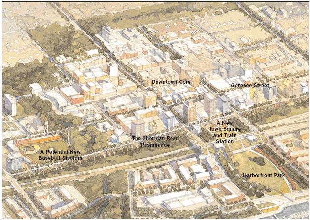
7 A Vision for the Lakefront and Downtown Downtown Waukegan will become a vibrant city center, a place for jobs, shopping, entertainment and urban living. The South Lakefront and the Harbor will become home to new waterfront neighborhoods. The North Lakefront will become an international model for environmental and ecological restoration. The transformation of Waukegan s Lakefront and Downtown will signal a broader transformation of the city and its place in the region. The First Step: Downtown Waukegan will be known for its revived Downtown: a destination for jobs, entertainment, unique retail and popular lunch and dining spots. It will be a regional center where people work, live and play. New housing and cultural and educational institutions will create a vibrant scene at all times of the day. Beautifully landscaped streets and city parks will draw people from homes and offices. Genesee Street, Sheridan Road, Clayton Street and others will be active streets. Downtown will also extend to the Harborfront with improved pedestrian and open space connections. The Waukegan River and its ravines will be restored. A variety of trails will be incorporated along the ravines. The mouth of the Waukegan River will be widened, where a significant new city park will be established. A Near Term Opportunity: The South Lakefront A new neighborhood will be established along the South Lakefront, reflecting the best of traditional neighborhood family housing. A new lakefront park will extend along the entire shoreline of this new neighborhood. New Neighborhoods: The Harborfront and the North Harbor A new district will grow at the Harborfront between a new Intermodal Transit Center and a regionally renowned marina. It will offer housing, boat service and construction, and marina-related retail. This new neighborhood will be organized around a central open space connecting Downtown to the lake edge. Waukegan Harbor will be a Great Lakes center for sailing and boating. Visitors to the marina will shop at the Harborfront and Downtown. A Harborfront Park will be Waukegan's new civic garden. Festivals, special events, family sports and entertainment will bring people to Waukegan from around the region. The North Harbor will take advantage of its waterfront location and lake and harbor views to become a primarily residential mixed-use neighborhood. Product development, boat service and launch facilities and civic and education activities will also be part of this new neighborhood. A Legacy Project: Restoring the North Lakefront The North Lakefront will emphasize open space, ecological restoration, wetlands, habitats and public access. It will be a place for play, relaxation and reflection. Public access to the water's edge will be maximized. Waukegan's North Lakefront will be known for its far reaching efforts to restore its lakefront environment. Clean land, air and water will provide a place for native vegetation, wildlife, recreation and education to come together. Natural features will be restored. New environmental facilities that celebrate this unique place and an ecological approach to industry and utilities will bring regional, national and international visitors. 2


8 Guiding Principles Waukegan s new Town Square will connect downtown to Lake Michigan The plan will provide new ways to experience the Lakefront The plan for Waukegan s Lakefront and Downtown is built upon the following principles: 1. Emphasize Mixed-Use Transit-Oriented Development in the Downtown and the Harborfront Downtown will become a compact, walkable center for jobs, living, learning, entertainment, shopping and dining. Mixed-use districts will be established around Waukegan's Harbor. 4. Restore the Lakefront into a Regional Environmental and Recreational Asset Waukegan will be known for the restoration of its lakefront environment, where clean land, air and water will enhance ecological restoration and wildlife protection and complement recreational opportunities 2. Create Strong Pedestrian, Transit and Roadway connections between Downtown and the Lakefront Downtown and the Lakefront will be connected by strong, clear pedestrian, bicycle, roadway and transit connections 5. Create a Transportation Framework that Allows Clear Access to the Lakefront Modifications to the existing road and infrastructure should clarify access to new development, strengthen routes to the Lakefront, establish streets as civic places, and consolidate underutilized land 3. Protect, Restore and Enhance Waukegan's Ravine and Park System Waukegan's bluffs, rivers and ravines comprise an irreplaceable open space asset, and will be protected and enhanced 6. Encourage Harbor-Related Uses that Complement an Environmentally-Based Lakefront The Harbor will evolve into a regional center for sailing and boating. The adaptation of remaining industry and utilities to a new vision for the Lakefront will establish Waukegan as an international model for sustainability 3

9 The Master Plan 4

10 5 The City of Waukegan Lakefront Downtown Master Plan Open Space Framework

11 Development Framework 6
12
13 2 CREATING A GREAT CITY


14 Enhancing Waukegan s Role as a Regional Center WAUKEGAN'S PLACE IN THE REGION As the Master Plan is implemented, Waukegan will re-establish its position as a significant regional city. The master plan builds upon Waukegan's three greatest regional assets: its marina, its lakefront ecosystem, and its location on a regional rail line. The marina and harbor represent the only deep-water port between Milwaukee and Chicago, and will play a role in the future of recreational and commercial maritime uses on Lake Michigan. The lakefront ecosystem is an example of a classic Lake Michigan dune system, and is an amenity on par with Illinois Beach State Park to the north. The enhancement and unification of Waukegan's lakefront, together with links to the Park, will create an unparalleled ecological resource for the State of Illinois. Waukegan's position within the Metra commuter rail network will also be enhanced by the Master Plan. As the proposed Metra circumferential line is completed and service to Waukegan is enhanced, the city's ability to serve an expanded transit customer base will be strengthened by a new intermodal transit center. Current and future Metra rail REGIONAL ACCESS Distinguish Waukegan as a city well-served by rail transit Metra commuter rail provides access from Waukegan to the North Shore, Kenosha and Downtown Chicago Future Metra expansion positions Waukegan as a key intermodal transit center at the intersection of the proposed regional circumferential Metra Line Strengthen Waukegan's connections to the regional roadway network Enhance links to interstate and state highway systems Create distinct gateways to Waukegan from interstate and state highway systems Highway access to Waukegan 7


15 The Region REGIONAL OPEN SPACE Promote Waukegan's Lakefront as a regional ecological asset The Waukegan Lakefront adjoins one of the state's finest ecosystems: Illinois Beach State Park The Waukegan River is a hidden regional treasure that once provided a safe port for passing vessels Create recreational connections to other open space systems within Lake County Create connections to Illinois Beach State Park, forest preserves and city parks Waukegan offers access to a rich collection of open spaces REGIONAL DEVELOPMENT Strengthen Waukegan's role as the urban destination in Lake County Build on Waukegan's growing population and diversity Build on the market strength of the North Shore and Lake County Transform the perception of Waukegan into that of a city offering a high quality of life Distinguish Waukegan as a regional tourist destination Waukegan is midway between Chicago and Milwaukee, and offers rich cultural opportunities Leverage Waukegan's adjacency to Illinois Beach State Park and Great Lakes Naval Training Center, each of which bring a significant number of visitors to the area Promote Waukegan's maritime assets Waukegan is the only deep-water harbor between Lake Calumet on Chicago's South Side and Milwaukee The current Harbor is a major regional recreational amenity Waukegan is part of the dynamic Northern Illinois region 8


16 Creating a Great Civic Presence: The City of Waukegan Waukegan's Downtown has a rich history as the center of a vital and diverse city. The Master Plan enables the Lakefront and Downtown to reassert itself as the symbolic, functional, and spiritual center of Waukegan. In an age of faceless strip-malls and an ill-defined public realm, strengthening the Lakefront and Downtown as the center of Waukegan is of primary importance. The Master Plan will achieve this by creating gateway boulevards into the Downtown at Grand, Washington, and Belvidere streets. Further, it proposes to strengthen Sheridan Road particularly through the downtown as a key north/south street. The plan also proposes the gradual relocation of industrial uses from the lakefront to existing appropriate districts in other parts of the City west of Downtown. This allows the lakefront to continue to evolve from an inaccessible industrial-based area to a Lakefront that is an asset for the entire city and a place for new neighborhoods. The downtown and lakefront are the historic center of Waukegan CITY ACCESS Strengthen key gateways to Waukegan Create identifying signage to Downtown at I-94 and US Route 41 Transform Grand Avenue, Washington Street and Belvidere Road into civic boulevards connecting neighborhoods and Downtown Strengthen Sheridan Road as an important north-south corridor into Waukegan Create a seamless transit network for the city Link western neighborhoods to the Downtown and Harborfront by strengthening existing bus service Connect bus lines to the proposed intermodal center and Metra Rail Create civic boulevards that provide clear links to the downtown and lakefront 9


17 The City CITY OPEN SPACE Create an accessible Lakefront for all of Waukegan's Citizens Connect the Lakefront to adjacent open space amenities, via trails and bike paths Maximize public access along the Lakefront Re-connect natural resources to Illinois Beach State Park and other open spaces Preserve, protect and restore Waukegan's unique ecological resources Acknowledge the Lakefront as Waukegan s defining natural amenity Enhance the city's ravine system as a great open space resource Preserve and enhance the lakefront bluff as an open space resource Provide connections between open-space resources to maximize recreational opportunities for all residents Connect the lakefront to adjacent open space amenities CITY DEVELOPMENT Establish Downtown as the highest-density development center for the City Create a dynamic, mixed-use downtown that is active during the day, evening and weekend Strengthen Waukegan s residential neighborhoods Unlock the development potential of the Lakefront Create new residential and mixed-use development districts at the lakefront Reconfigure infrastructure to set the stage for lakefront redevelopment Prepare the Lakefront for redevelopment by encouraging industrial uses to relocate Relocate industrial uses that are not water-dependent to Waukegan s other industrial districts Strengthen industrial districts near the Waukegan airport and along transportation corridors Prepare the Lakefront for redevelopment by encouraging industrial uses to relocate 10

18 A Transformation: The Lakefront and Downtown 11


19 The Lakefront and Downtown The Lakefront and Downtown form the project focus area. Encompassing approximately 1400 acres, this area includes a 155-acre Downtown as well as underutilized industrial parcels, prime lakefront land, and extensive road and rail infrastructure. The Lakefront and Downtown area will be the focus of three primary initiatives. The first is to reconnect the Lakefront with both the Downtown and surrounding neighborhoods by eliminating or minimizing barriers such as the Amstutz Expressway and rail lines and yards. The second is to create new Lakefront development districts that celebrate Waukegan's maritime location. The third initiative is to reconnect the Lakefront's disparate open space components into a unified recreational and ecological resource that will be a model within the Great Lakes region. The Master Plan articulates a vision that balances new growth with open space, creating approximately 200 acres of new development. Formed into distinct neighborhoods, or development districts, this acreage is the equivalent of two new downtowns. Complementing that development, over 50% of the study area will remain as open space. These extensive natural areas will provide a legacy landscape for the city and contribute to the transformation of the Lakefront into a civic asset. ACCESS AT THE LAKEFRONT AND IN DOWNTOWN Reorganize infrastructure to meet today s transportation needs Reduce barriers between the Downtown and the Lakefront Narrow the Amstutz Expressway right-of-way, and modify its character to create a Lakefront Boulevard Re-align Metra tracks to the west in the Harborfront are Relocate passenger and freight rail-yards from the Harborfront to north of Grand Avenue Create a new decked park over the reduced Amstutz right-ofway and rail lines, connecting Downtown to the Harborfront Create a network of streets that serve multiple purposes Design streets that (1) provide automobile access (2) create great places (3) build community (4) are an aesthetic asset to the city and (5) unite development districts and minimize barriers Enhance bridges at Grand Avenue and Belvidere Road to provide greater civic presence and access to the Harborfront and Lakefront Create an Inter-modal transit center serving all development districts Enhance Pace bus service to lakefront areas Provide seamless interface between rail, bus and automobile Provide appropriate parking resources for all districts Create a network of streets that extend to the Lakefront Create opportunities for shared parking between weekend and weekday functions 12


20 The Lakefront and Downtown OPEN SPACE AT THE LAKEFRONT AND IN DOWNTOWN Identify, protect, and enhance Lakefront areas of high-quality habitat and ecology Restore and enhance pre-settlement ecological and hydrological systems Reconnect fragmented ecosystems as significant public openspace amenities Implement the Waukegan Moorlands, a unifying environmental initiative for the Lakefront Create great new places at the Lakefront Create parks that complement their Lakefront location Maximize open spaces at the lake edge Provide places for active and passive recreation at the Lakefront Ensure connectivity between Lakefront open space systems Maximize public access to the lake edge Provide recreational and ecological links between new open spaces Connect open spaces to Downtown and new neighborhoods Open space at the Downtown and Lakefront Proposed Waukegan Moorlands New trails connect to open spaces A dune overlook A Harborfront promenade 13


21 The Lakefront and Downtown DEVELOPMENT AT THE LAKEFRONT AND IN DOWNTOWN Create clear development districts that offer a sense of completion at each stage Start with Downtown as the first development district Create new mixed-use, waterfront neighborhoods: the South Lakefront, the Harborfront, and the North Harbor Establish a pedestrian-scaled framework of streets, blocks and development parcels Build on existing assets Governmental and educational base Historic buildings Stable adjacent neighborhoods Transit access and roadway infrastructure A Lakefront location Consolidate infrastructure to increase development area Narrow the Amstutz and decommission it as an expressway Move Metra lines to the west Relocate rail yards from the Harborfront Decommission and consolidate the EJ&E railroad and Pershing Road Downtown and Lakefront neighborhoods Take advantage of publicly-owned land to achieve the trans- Formation of the Lakefront and Downtown Establish new development districts 14
22
23 CREATING GREAT PLACES 3


24 The First Step: Strengthening Downtown Waukegan Strengthening Downtown is the first step in the transformation of the Downtown and the Lakefront. By taking advantage of existing infrastructure, approximately 25 acres of vacant land and underutilized buildings are available for immediate development. The vision for Downtown is to complement the city's existing cultural and institutional assets with expanded retail, residential, office, and specialty uses. This dynamic mix of uses will create a Downtown that is lively and active throughout the day, into the evening, and on weekends. It will also establish a broader residential population to support retail uses and heighten civic involvement in the future of Downtown. Significant new specialty uses such as a minor league baseball stadium and the renovated Genesee Theatre will attract visitors from throughout Waukegan and the surrounding region. A vibrancy will be returned to the Downtown, restoring its historic character and uniqueness. DOWNTOWN ACCESS Strengthen gateways into Downtown Establish Grand Avenue, Washington Street, Belvidere Road and Sheridan Road as great entry boulevards Create a new inter-modal transit center to serve Downtown Strengthen pedestrian connections to Metra rail and Pace bus transit to encourage transit use Emphasize opportunities for shared parking facilities New theatre and entertainment uses can share office parking Baseball stadium Enhance and improve the quality and character of Downtown streets Strengthen the pedestrian quality of all Downtown streets with attractive street furnishings and landscaping Revive Genesee Street as a great retail corridor with stores, restaurants, entertainment and education Emphasize evening entertainment along Clayton and Genesee Street Develop Sheridan Road as the new residential face of Downtown with taller buildings Emphasize opportunities for shared parking in Downtown Ensure the Genesee Theatre and other entertainment activities are served by providing a parking facility at Clayton and County 15


25 The Downtown DOWNTOWN OPEN SPACE Re-establish the Waukegan River and ravine system as a great natural resource Stabilize the ecological condition and re-establish native vegetation in the Downtown portion of the ravines Reduce direct storm-water discharge into the ravines Incorporate a variety of trails throughout the ravines Create a downtown with a network of parks, plazas and promenades Create a new Waukegan town square, with connections over a narrower Amstutz Create a new public promenade above the bluff along Sheridan Road Create appropriate plazas and parks to mark gateways and special places Strengthen "green" streets as important links between open spaces Restore the Waukegan River and ravine system as an open space Create a new Town Square as a transition between the Downtown and Lakefront 16


26 Creating a Mixed-Use Downtown Downtown Districts DOWNTOWN DEVELOPMENT Realize immediate opportunities for new development in Downtown Encourage new retail and dining on Genesee Street Create diverse retail opportunities for residents, workers and visitors Emphasize government and office on County Street and Martin Luther King Jr. Avenue Strengthen existing governmental, educational, and institutional uses Leverage opportunities presented by Waukegan's role as the county seat. Create restaurants and shops to attract employees and visitors to the Lake County building Encourage the growth of educational institutions in Downtown Encourage new residential infill in Downtown Pursue the opportunity for up to 400 new homes, 150,000 square feet of retail, 200 hotel rooms and 300,000 square feet of office development Opportunity sites in the governmental core Downtown opportunity sites 17 Sheridan Road - The face of Waukegan

27 Creating Great Places 18


28 A Near Term Opportunity: The South Lakefront The South Lakefront development district represents a near-term opportunity for Waukegan. Currently comprised of abandoned or under-utilized parcels, the South Lakefront offers outstanding lake frontage. This 125-acre district will offer approximately 80 acres of development land. The lake edge will be returned to the citizens of Waukegan as a permanent, public lakefront park. Immediately adjacent to this park will be a new southerly extension of Pershing Road, forming a new "Lakeshore Drive" for Waukegan that will unite the entire lakefront. The third component of the South Lakefront district will be a new 50- acre new residential and small-scale commercial neighborhood. The residential component will consist of single-family housing, townhomes and stacked flats that complement Waukegan's traditional neighborhoods. Neighborhood commercial uses, such as small convenience stores or dry-cleaners, will form focal points within the larger residential area. ACCESS TO THE SOUTH LAKEFRONT Create a network of attractive, landscaped, walkable neighborhood streets that lead to the Lakefront Extend and enhance Pershing Road as a new "Lakeshore Drive" for Waukegan Allow for future roadway connections to North Chicago Provide a continuous lakefront pathway that connects to the Harborfront Mid-block alleys will provide access to residential parking The South Lakefront District A new neighborhood at the South Lakefront 19


29 The South Lakefront OPEN SPACE AT THE SOUTH LAKEFRONT Create a significant lakefront park that defines the district Ensure a continuous public lake edge Create connections to the mouth of the Waukegan River Create great neighborhood parks and playgrounds that define residential identity Allow for future open space connections to the south Define the mouth of the Waukegan River as a significant place on the Lakefront DEVELOPMENT AT THE SOUTH LAKEFRONT Establish a new mixed-density residential neighborhood with up to 500 new homes Incorporate supporting retail uses that provide neighborhood services Create development parcels that allow the neighborhood to be built in complete increments Ensure homes face the street and offer attractive, well articulated facades The South Lakefront will include single-family homes, townhomes, and neighborhood-serving retail 20


30 Creating New Neighborhoods: The Harborfront and North Harbor The Harborfront (lower left) and North Harbor (upper right) The Harborfront and North Harbor development districts offer a new centerpiece for the Lakefront. These neighborhoods are approximately 335 acres in size and provide approximately 120 acres for development. With the closing of key manufacturing plants, and reduced dependence on lake-based shipping, development adjacent to Waukegan's harbor will shift to a more diverse mix of recreational, residential and commercial uses. The Master Plan expands and enhances this evolution by proposing mixeduse, marina-based development that will re-define Waukegan's harbor for the next century. The 95-acre harborfront will include approximately 35 acres of development. The 240-acre North Harborfront area will include approximately 85 acres of development. The Harborfront and North Harbor districts will be characterized by a rich diversity of housing types and marina-based retail. These will be organized around an intermodal transit center and a new Harborfront Park. Current marina-based uses will be encouraged to stay within the districts, but relocate to sites more suited to their long-term needs. Boat launch facilities will be relocated to an area that can accommodate their parking needs. Waukegan's harbor will become a destination, not only for boaters and anglers, but also for area residents that want to be a part of a vibrant, diverse, mixed-use waterfront district. The Harborfront and North Harbor will be places to live, recreate, spend a weekend or an afternoon. They will perpetuate the spirit of Waukegan's maritime history. ACCESS WITHIN THE HARBORFRONT AND NORTH HARBOR Extend Waukegan's framework of streets to the Harborfront Create new streets that extend the grid of Waukegan's Downtown to the Harborfront Create clear access and view corridors to the lake, especially at the gateway boulevards of Washington, Grand and Belvidere Enhance the pedestrian environment of streets leading to the harbor Transform the EJ& E rail right-of-way into a new Pershing Road to serve the Harborfront and North Harbor Provide appropriate parking for all uses Emphasize opportunities for shared parking facilities that can be used by commuters, marina users, shoppers and evening and weekend visitors Provide adequate marina-related parking for boaters and anglers 21


31 The Harborfront and North Harbor Create a transit-oriented, pedestrian-friendly district Create pedestrian connections between Downtown and the Lakefront Create high-quality pedestrian-scaled streets throughout Establish clear pedestrian connections to Metra and Pace buses to encourage transit use Locate the Metra Station and Intermodal Center between Madison and Washington The potential Metra station entry from the bus drop-off A cross section through the new Town Square and Intermodal Center The proposed Intermodal Center is the focus of the transit-oriented Harborfront District 22


32 The Harborfront and North Harbor OPEN SPACE AT THE HARBORFRONT AND NORTH HARBOR Create continuous public access along the waterfront Implement a waterfront promenade for pedestrians Maximize public access to the marina Ensure recreational links to the north and south Create new public places that connect residents to the lake Create a great civic open space at the Harborfront that extends to the marina Maintain and enhance Waukegan's beaches Incorporate the City of Waukegan water-treatment facility into the open space framework Create a new city park to the north of the North Harbor Create a theme of ecological restoration for the park Incorporate new technologies for bioremediation Establish opportunities for large-scale environmental art Provide an open space connection from the bluff to the lake edge


33 The Harborfront and North Harbor DEVELOPMENT OF THE HARBORFRONT AND NORTH HARBOR Create marina-oriented, mixed-use neighborhoods that emphasize their waterfront locations Provide up to 2500 new homes Emphasize marina-related service and retail, hospitality and education activities Provide uses that complement one of the few full-service, commercial marinas in Illinois Encourage existing industries to incorporate green principles Relocate long-term boat parking and storage north of Grand Avenue Relocate incompatible existing uses to other areas still within Waukegan Strategically locate new development to support the longterm vision for the Lakefront Consolidate infrastructure to create viable development parcels Organize higher-density development around the new Harborfront Park and inter-modal station Consolidate educational or institutional facilities adjacent to the beach area at the North Harbor Encourage the relocation and consolidation of appropriate marina-related uses Encourage marina-related business expansion to the central and western portions of the North Harbor Encourage material storage, distribution and industrial operations to relocate away from the North Harbor after five years Move boat launch facility to the north of its current location Provide appropriate boat launch parking while encouraging the use of alternative and shared parking adjacent to the waterfront 24

34 A Legacy Project: The North Lakefront The North Lakefront represents a long-term, legacy project for the city. It is the city's greatest open-space resource, and is a unique geological, environmental and ecological feature. The long-term vision for the North Lakefront is to return it to its former natural magnificence while accommodating existing long-term land uses. The vision for the North Lakefront includes protecting and enhancing existing natural amenities and the creation of the Waukegan Moorlands. This extensive open-space area will restore historic wetlands while providing recreation trails and wildlife habitat. As the Moorlands are implemented, the City will work with Midwest Generation and North Shore Sanitary District to create a continuous open-space system that incorporates private and public land. In addition, access to the lake will be improved, the beach areas will be connected with bike and pedestrian trails, and a proposed city park will be initiated. Waukegan possesses a natural environment that exists in very few places in the world. This environment, characterized by a freshwater "dune and swale" system adjacent to an upland bluff and ravine system, can be seen in an almost pristine condition in Illinois Beach State Park (IBSP) immediately to the north of the project area. The fundamental landscape initiative of the plan is to acknowledge, enhance and expand this environment by building on Waukegan's remaining ecological assets and strengthen connections to IBSP. 25


35 The North Lakefront Over the course of Waukegan's settlement and growth, many natural features of the original lakefront landscape have been destroyed or severely compromised by industrial development. Despite the negative effects of industrial activity on Waukegan's lakefront, many valuable ecological systems remain. These include an excellent "foredune" system immediately adjacent to the beach, small remnant plant communities in abandoned sites and wetlands adjacent to roads and railroads. As shown in the diagrams above, Little Dead River, an important hydrological connection between Waukegan's upland areas and Lake Michigan, has been gradually filled, severely compromising its role as a natural water filter. The Master Plan's proposed Waukegan Moorlands will reconstruct Little Dead River, re-establishing a valuable hydrologic and recreational amenity for the city. Because of access restrictions on the North Shore Sanitary District and Midwest Generation sites, in some instances native plant and animal communities have remained. The Master Plan recommends working with these long-term lakefront partners to establish limitedaccess easements that reconnect and enhance these existing native systems. Through the use of plants indigenous to Waukegan, enhancing remaining ecological systems, and celebrating the uniqueness of this place, the vision for the North Lakefront will begin to heal Waukegan's unparalleled lakefront landscape. 26


36 The North Lakefront ACCESS TO THE NORTH LAKEFRONT Ensure public access to the Lakefront Improve Greenwood Avenue as an important route to the Lakefront To protect sensitive areas, limit vehicular and pedestrian access Move Pershing Road to the EJ&E right-of-way, creating a new Lakeshore Drive through the North Lakefront Develop a system of trails and bike paths that allow full access to all areas of the North Lakefront Use trails and bikeways to link the newly created Moorlands to adjacent open spaces Create a pedestrian and bicycle link to Illinois Beach State Park Provide pedestrian routes and observation points along the beachfront Utilize power line right-of-way to provide recreational access west to Robert McClory bike trail Design roads and trails that can be crossed by recreational users and wildlife Create boulevards where appropriate, reducing the perceived width of streets Design streets and trails that allow storm-water and wildlife to move freely between park areas Employ context-sensitive design standards for all infrastructure projects DEVELOPMENT AT THE NORTH LAKEFRONT Limit North Lakefront development to primarily recreational uses Limit new buildings to recreational and educational facilities Incorporate existing industrial uses into the open space system Improve the environmental stewardship of land, air and water by power generation and sanitary district facilities "Soften" edges of existing industrial sites by creating landscapes similar to the natural areas they adjoin Incorporate North Shore Sanitary District's overflow into a series of constructed wetlands within the Waukegan Moorlands 27


37 The North Lakefront OPEN SPACE AT THE NORTH LAKEFRONT Implement the "Waukegan Moorlands," an open-space initiative that restores pre-settlement landscapes and hydrologic patterns Re-establish natural waterways and wetlands Create constructed wetlands Re-establish wildlife habitats, especially for migrating and over-wintering birds The Moorlands will offer a living example of the North Lakefront's natural ecosystems Protect and restore the beach and lakefront environment Establish a permanent, protected, dune zone at the lake edge Establish a fore-dune wetland system that provides plant and animal habitat Create open-space initiatives that link the Moorlands to the lakefront Establish a new ecological park north of the North Harbor. Use the Johns Manville site for recreational uses Create an east-west open-space link at the southern edge of the Midwest Generation site Create ecological continuity between the North Lakefront's diverse places Ensure hydrological systems are inter-connected Design sites to have "porous" edges. Eliminate unnecessary fences or other man-made barriers 28
38
39 CONCLUSION 4


40 Implementation of the Master Plan Waukegan s Downtown and Lakefront is poised for change The city must seize the existing planning and development momentum to ensure realization of the plan. The following steps outline a possible implementation scenario. Strengthen existing assets in Downtown Activate storefronts on Genesee Street to support and respond to the re-opening of the Genesee Theatre Create a parking structure to support the Genesee Theatre Initiate the transformation of the Harborfront with the reconfiguration of the Amstutz Expressway and commuter and freight rail lines and yards and other infrastructure Implement a strategic environmental remediation methodology to unlock the Lakefront for public use and future public and private investment Create new opportunities in Downtown and the South Lakefront Redevelop at least three Sheridan Road sites in downtown for either housing, office hospitality or retail activities Encourage new retail and dining Strengthen governmental, educational and institutional activities Encourage new residential infill Prepare the South Lakefront for redevelopment A near term opportunity: The South Lakefront Establish a new residential neighborhood Create a network of attractive, walkable neighborhood streets Ensure a continuous public lake edge 29


41 Implementation of the Master Plan Setting the stage at the Harborfront Consolidate infrastructure to set the stage for Harborfront redevelopment Create new streets that extend the grid of Waukegan s downtown The new Harborfront neighborhood and the Intermodal Center Create a decked park over the Amstutz and Metra lines as the new town square Build a new intermodal transit center Create a new Harborfront Park that leads to the water s edge Establish a new mixed-use district with marina-related services and retail, residential, hospitality and education activities The new North Harbor neighborhood Establish a new mixed-use residential district that takes advantage of lake views and access to beaches and the North Lakefront Implement North Lakefront open spaces Create a great city park at the North Harbor Implement the Waukegan Moorlands Initiate stewardship strategies with major land holders 30
42 Conclusion This Master Plan represents a major step in the transformation of Waukegan's Downtown and Lakefront. It has brought city and other government officials, business leaders and the residents of Waukegan together to establish shared goals for the future. The transformation of Waukegan's Downtown and Lakefront will offer enormous public benefits in terms of new homes, stores, entertainment and offices, recreation resources, high quality transit service and a new framework of streets and public spaces. New revenues for the City of Waukegan and new jobs for residents will result. Sustained and focused public and private investment will be required to strengthen Downtown and unlock the full potential of the Lakefront. Waukegan, Lake County and the entire metropolitan region will benefit. The City of Waukegan is committed to working with State and Federal agencies, as well as property owners and future developers to achieve the vision established by this plan. Technical Analysis and Supplemental Report Substantial analytical work was carried out during the creation of this Master Plan. This included: Site assessment Ecological assessment Market assessment Development programming Land assembly analysis Environmental strategy analysis Traffic and transit impact analysis Implementation budget Economic and fiscal impact analysis This analysis is compiled in a supplemental document which can be made available for review by contacting: City of Waukegan Waukegan Department of Planning and Zoning T F
43 City of Waukegan Richard Hyde Mayor The City of Waukegan Lakefront Downtown Master Plan Acknowledgements Ray Vukovich Director of Governmental Services Russ Tomlin Director of Planning, Zoning and Economic Development Noelle Kischer Senior Planner Steve Sabourin Senior Planner/Plat Administrator John Moore City Engineer Ruth Wuorenma Development Advisor Waukegan City Council Samuel Cunningham First Ward John Balen Second Ward John Rickerd (through April 2003) Third Ward Gregory Moisio (since May 2003) J.A. Tony Figueroa Fourth Ward Frank Harris (through April 2003) Fifth Ward Edith Edie Newsome (since May 2003) Fifth Ward Lawrence TenPas Sixth Ward Patrick Needham Seventh Ward Richard Larsen (since May 2003) Eighth Ward Rafael Rivera (since May 2003) Ninth Ward New Harbor City Renaissance Commission Jody Armstrong-Moon Cranston Byrd Gary Dowty Tony Figueroa Marc Huber Dale Johnson Tom Muscarello Tom O'Connell (Chair) Tim O'Leary John O Meara Chuck Wesselhoft (Recorder) David Young Master Plan Consulting Team Skidmore Owings and Merrill LLP Master Planning Development Concepts, Inc Market Analysis and Development Strategies CH Johnson Consulting Economic and Market Analysis Land Strategies, Inc Transportation Planning Conservation Design Forum Ecological, Open Space and Landscape Planning Site Design Group, Ltd. Park and Streetscape Concepts US Equities Environmental Resource Identification Sally Foster Community Outreach 32
places Mooloolaba s heart five
 five places the mooloolaba heart 1 Flexible community event use of school oval 2 Enhanced streetscape District cycle route Future cross-block pedestrian link 5 Existing school buildings New signalised
MAC Meeting. February 2, 2017
 MAC Meeting February 2, 2017 Community Engagement Over 1,000 stakeholders consulted Board and Staff workshops 90 participants 9 Focus Groups (arts & culture, festivals/music, hotels, dining & beer, sports,
CONTENTS. 1 Introduction Always Moving Forward while Building on the Past A Dynamic Destination... 5
 2010 STRUCTURE PLAN - 2 - CONTENTS 1 Introduction... 5 1.1 Always Moving Forward while Building on the Past... 5 1.2 A Dynamic Destination... 5 2 Map A... 6 Exhibition Place and its Neighbours... 7 3 Demonstration
HARBOUR EDGE STITCH. Uniting the Waterfront with the City Centre
 78 AC_BEU_CCMP_2_TM1_4 _FD.indd 78 20/07/12 12:04 PM 01 HARBOUR EDGE STITCH Uniting the Waterfront with the City Centre 01 VISION OUR 2032 VISION IS: Quay Street as a high-quality Harbour Edge space that
The Sunshine Coast is part of the global community and generates wealth through export, high-value industries and new investment.
 3.2 Strategic intent 3.2.1 Shaping growth an overview In 2031, the Sunshine Coast is renowned for its vibrant economy, ecological values, unique character and strong sense of community. It is Australia
2.1 Redevelopment Area
 DESIGN PRINCIPLES 7 2.1 Redevelopment Area The Asbury Park Waterfront Redevelopment Area that was designated in November 7, 1984 remains the same area under this plan amendment (see attached map). The
A VISION FOR EL MIRAGE
 el mirage A VISION FOR EL MIRAGE OASIS, ARIZONA A thriving desert jewel destination with a strong arts district, high-wage employment parks system joined together by cohesive, multi-use accessible trails
CHAPTER 3 PLANNING GOALS
 CHAPTER 3 PLANNING GOALS AND PUBLIC INPUT INTRODUCTION This portion of the Algonac Master Plan is intended to outline a course for action in achieving the community s vision for the future. Throughout
NEWBORO AND PORTLAND HARBOUR REDVELOPMENT PLANS
 INTRODUCTION The Municipal docks in both Newboro and Portland were transferred to the Township of Rideau Lakes by Parks Canada in 2002. Little has been done to improve the docks physical condition or role
Airport Planning Area
 PLANNING AREA POLICIES l AIRPORT Airport Planning Area LOCATION AND CONTEXT The Airport Planning Area ( Airport area ) is a key part of Boise s economy and transportation network; it features a multi-purpose
The Vision for the San Juan Islands Scenic Byway
 The Vision for the San Juan Islands Scenic Byway 2 Judd Cove, Orcas Island, Courtesy of Kurt Thorson (kurtthorson.com) and San Juan County Land Bank Vision for the San Juan Islands Scenic Byway The San
Non-Motorized Transportation
 Non-Motorized Transportation Non-motorized facilities are important components to the transportation system. They provide an environmentally-friendly, low-cost mode of travel. Some of the facilities can
IL 390 Station. Wood Dale Open House Summary 5/18/17
 Wood Dale Open House Summary 5/18/17 The first public open house for the Wood Dale Comprehensive Plan took place on May 18 th, 2017. The program was conducted as a fun community event and there were 216
Washington Township MASTER PLAN. Addendum: Washington Township Master Plan
 Washington Township MASTER PLAN Addendum: Washington Township Master Plan CHAPTER XI RECREATION CORE DISTRICT Introduction The Recreation Core District generally encompasses the areas north of 30 Mile
Area Surrounding Maplewood Manor
 BAY CITY, MICHIGAN HOUSING COMMISSION Neighborhood Revitalization Plan Area Surrounding Maplewood Manor January 13, 2014 CITY COMMISSION DRAFT PLAN PRESENTATION BAY CITY, MICHIGAN 1 Planners Phil McKenna,
Economic Development and Tourism
 SECTION 4 SECTION 4 Economic Development and Tourism 4. Economic Development and Tourism Tourism plays a very important role in Niagara s economy, providing employment and generating business for support
Welcome to the Cross County Trail Public Input Session!
 Welcome to the Cross County Trail Public Input Session! Please sign in on the table below! What are we doing here? Camden County has proposed a bicycle and pedestrian trail spanning across the entire county.
University Region Non-Motorized Plan 2015
 Non-Motorized Transportation Non-motorized facilities are important components to the transportation system. They provide an environmentally-friendly, low-cost mode of travel. Some of the facilities can
Blueways: Rivers, lakes, or streams with public access for recreation that includes fishing, nature observation, and opportunities for boating.
 Parks, Open Space and Trails PRINCE WILLIAM COUNTY 2008 COMPREHENSIVE PLAN TRAILS PLAN CONTENTS The components of the trails plan are: Intent Definitions Goals, Policies, and Action Strategies Trails Map
CANNING CITY CENTRE. the new energy of the southeast
 CANNING CITY CENTRE the new energy of the southeast 2 INTRODUCTION From early beginnings as an important cultural and recreation place for the Beeloo Nyoongar people, to being a trading post connecting
Director, Community Planning, Toronto and East York District
 STAFF REPORT October 25, 2005 To: From: : Subject: Toronto and East York Community Council Director, Community Planning, Toronto and East York District Status Report OPA & Rezoning Application 05 117524
Yarmouth Technical Assistance Panel Oct 17, Yarmouth TAP
 Yarmouth Technical Assistance Panel Oct 17, 2017 Yarmouth TAP October 17, 2017 Westfield Technical Yarmouth Assistance Technical Assistance Panel, October Panel 26, 17, 2015 2017 About ULI the Urban Land
TOWN PLANNING SUBMISSION TO THE GREATER SYDNEY COMMISSION LANDS AT ARTARMON
 TOWN PLANNING SUBMISSION TO THE GREATER SYDNEY COMMISSION LANDS AT ARTARMON March 2017 TABLE OF CONTENTS 1.0 INTRODUCTION 3 2.0 THE SUBJECT SITE 4 3.0 STRATEGIC PLANNING CONTEXT 6 4.0 SUMMARY AND CONCLUSIONS
FEASIBILITY CRITERIA
 This chapter describes the methodology and criteria used to evaluate the feasibility of developing trails throughout the study areas. Land availability, habitat sensitivity, roadway crossings and on-street
STITCH TRANSFORMATIVE IDEA 3. SHORELINE STITCH. Re-connect the city to the waterfront and link the east and west Core Circle landscapes
 SHORE STITCH TRANSFORMATIVE IDEA 3. SHORELINE STITCH Re-connect the city to the waterfront and link the east and west Core Circle landscapes 126 LINE PUBLIC WORK 127 TRANSFORMATIVE IDEA 3. SHORELINE STITCH
Colorado Springs & Pikes Peak Region Destination Master Plan
 Colorado Springs & Pikes Peak Region Destination Master Plan Overview June 19, 2018 DESTINATION MASTER PLAN What is Destination Master Planning? Focus on infrastructure, facilities, services, attractions
REGION OF WATERLOO INTERNATIONAL AIRPORT AIRPORT MASTER PLAN EXECUTIVE SUMMARY MARCH 2017
 REGION OF WATERLOO INTERNATIONAL AIRPORT AIRPORT MASTER PLAN EXECUTIVE SUMMARY MARCH 2017 Contact: Chris Wood, Airport General Manager cwood@regionofwaterloo.ca (519) 648-2256 ext. 8502 Airport Master
Waterfront and Marina Strategic Plan. May 26, 2015 Infrastructure, Investment & Development Committee
 Waterfront and Marina Strategic Plan May 26, 2015 Infrastructure, Investment & Development Committee 1 Purpose Background Update work completed or underway Vision & principles Balanced plan with opportunities
Part Three : COMMUNITY PLAN AREAS AND SPECIAL STUDY AREAS SACRAMENTO 2030 GENERAL PLAN. Introduction
 Special study Areas Part Three : COMMUNITY PLAN AREAS AND SPECIAL STUDY AREAS SACRAMENTO 2030 GENERAL PLAN Introduction Beyond the boundaries of the 2030 General Plan, the City has defined Special Study
This page has been intentionally left blank.
 This page has been intentionally left blank. Chapter 2 2-2 2. Growing the Economy In many ways, the Niagara Region is a community of communities and this is becoming increasingly so. It is made up of towns
SOUTH INTERCHANGE AREA
 Santaquin City General Plan 1 Location and Characteristics The South Interchange Area of Santaquin is located west of Interstate 15 and south of 500 South (Figure 1). It includes properties already annexed
Update: Manhattan Community Board 1 Land Use, Economic Development & Zoning committee February 12, 2018
 Update: Manhattan Community Board 1 Land Use, Economic Development & Zoning committee February 12, 2018 1 GOVERNORS ISLAND IS FOR NEW YORKERS 2 WE RE MOVING TOWARDS A YEAR-ROUND, 24 HOUR COMMUNITY 3 Governors
Bloor Street West Rezoning Application for a Temporary Use By-law Final Report
 STAFF REPORT ACTION REQUIRED 3741 3751 Bloor Street West Rezoning Application for a Temporary Use By-law Final Report Date: June 12, 2007 To: From: Wards: Reference Number: Etobicoke York Community Council
PUBLIC TRANSIT IN KENOSHA, RACINE, AND MILWAUKEE COUNTIES
 PUBLIC TRANSIT IN KENOSHA, RACINE, AND MILWAUKEE COUNTIES #118404v1 Regional Transit Authority June 19, 2006 1 Presentation Overview Existing Public Transit Transit System Peer Comparison Recent Transit
COLLEGE STREET STUDY Community Consultation Meeting. December 2015
 COLLEGE STREET STUDY Community Consultation Meeting December 2015 2 Agenda 6:30 pm Introductions, Agenda Review and Welcome 6:40 pm Presentation Planning Recommendations 7:30 pm Questions and Discussion
Macleod Trail Corridor Study. Welcome. Macleod Trail Corridor Study Open House. Presentation of Proposed Design Concepts
 Macleod Trail Corridor Study Welcome Macleod Trail Corridor Study Open House Presentation of Proposed Design Concepts Study Purpose Develop a corridor plan for Macleod Trail that aligns with The City s:
Lake Erie Commerce Center Traffic Analysis
 LOCATION: East of NYS Route 5 at Bayview Road Town of Hamburg Erie County, New York PREPARED BY: Wendel Companies 140 John James Audubon Parkway Suite 200 Amherst, New York 14228 January 2012 i ii Table
DEMOGRAPHICS AND EXISTING SERVICE
 EXECUTIVE SUMMARY The Central Corridor light-rail transit (LRT) project will open in 2014 and operate between downtown Minneapolis and downtown St. Paul, serving the University of Minnesota and University
AUGUST 5, 2010 UPDATE # 3 AMTRAK/FEC PROJECT: STATION LOCATIONS AND CONCEPTUAL DRAWINGS
 AUGUST 5, 2010 UPDATE # 3 AMTRAK/FEC PROJECT: STATION LOCATIONS AND CONCEPTUAL DRAWINGS The Summer of 2010 has been a time of tremendous progress for the Amtrak/FEC Corridor project and its goal of restoring
URBAN DESIGN REPORT. Proposed Residential Development, Old Church Road, Caledon East
 Proposed Residential Development, Old Church Road, Caledon East TABLE CONTENTS: 1.0 DEVELOPMENT 1.1 Introduction-Analysis of Guiding Principles and Documents 1.2 Community Design and Architectural Design
MASTER PLAN July 24, 2014
 MASTER PLAN July 24, 2014 Vision Statement The newly expanded Rif Curaçao Seaport will enhance the island s ability to welcome guests to a vibrant and entertaining waterfront. The Rif Seaport Curaçao development
Everett Riverwalk Life style explore
 Life style explore Project Overview The 217-acre Everett Riverfront redevelopment is visible from I-5 with traffic counts charted at 170,000+ vehicles per day with direct freeway access from 4-way interchange.
Saginaw Charter Township Master Plan
 Saginaw Charter Township Master Plan Overview of Draft & Public Hearing August 20, 2014 230 South Washington Avenue Saginaw Michigan 48607 (989) 754-4717 www.spicergroup.com Saginaw Charter Township Master
AGENDA ITEM 5 D WAKULLA ENVIRONMENTAL INSTITUTE (WEI) TRAIL FEASIBILITY STUDY
 TRAIL FEASIBILITY STUDY") March 19, 2018 AGENDA ITEM 5 D WAKULLA ENVIRONMENTAL INSTITUTE (WEI) TRAIL FEASIBILITY STUDY TYPE OF ITEM: Action STATEMENT OF ISSUE The Wakulla Environmental Institute (WEI) Trail is one of several trails
March 19, 2018 AGENDA ITEM 5 D WAKULLA ENVIRONMENTAL INSTITUTE (WEI) TRAIL FEASIBILITY STUDY TYPE OF ITEM: Action STATEMENT OF ISSUE The Wakulla Environmental Institute (WEI) Trail is one of several trails
A summary report on what the community told us
 DECEMBER 2015 A summary report on what the community told us During August and September 2015, UrbanGrowth NSW in partnership with Newcastle City Council ran the Revitalising Newcastle community engagement
Port Everglades Master/Vision Plan Update
 Port Everglades Master/Vision Plan Update Environmental Stakeholder Meeting June 15, 2009 Discussion to Focus On: Updating the 2006 Port Everglades Master Plan Issues dealing with the Turning Notch Potential
 288.075, F.S. Florida Job Growth Infrastructure Application Response to Question 1A Provide the title and a detailed description of the public infrastructure improvements. The West River Riverwalk
Wilds. Headwaters. Lakes. Oxbows. Falls
 56 5 4 3 Wilds Headwaters Lakes Oxbows Falls 57 Zones It could be said the on-the-ground essence of this master plan appears within the next 6 pages of this report. As we learned in the preceding Cultural
CHULA VISTA DEVELOPMENT OPPORTUNITY. For Additional Information: Sean Bascom Lic#
 CHULA VISTA DEVELOPMENT OPPORTUNITY For Additional Information: Sean Bascom 619.916.9179 bascom@scc1031.com Lic# 01862044 Image TAVA Third Avenue Village is the heart of Chula Vista s historic downtown.
Northeast Quadrant Distinctive Features
 NORTHEAST QUADRANT Northeast Quadrant Distinctive Features LAND USE The Northeast Quadrant includes all the area within the planning area that is east of Interstate 5 and to the north of State Route 44.
TEMPE BEACH PARK - RECOMMENDATIONS
 TEMPE BEACH PARK - RECOMMENDATIONS Tempe Beach Park has the potential to become a regional destination park, but it suffers from a host of physical and operational problems, as well as structural flaws.
National Strategy for a Sustainable Trail System
 National Strategy for a Sustainable Trail System Forest Service December 30, 2016 Message from the Chief The Forest Service manages the largest trail system in the country, with unparalleled opportunities
Spadina Avenue Built Form Study Preliminary Report
 STAFF REPORT ACTION REQUIRED Spadina Avenue Built Form Study Preliminary Report Date: July 9, 2014 To: From: Wards: Reference Number: Toronto and East York Community Council Director, Community Planning,
Hemisfair Civic Park. Vision and Program Plan
 Hemisfair Civic Park Vision and Program Plan OCTOBER 2013 Hemisfair Civic Park Vision and Program Plan Prepared under the direction of the Hemisfair Park Area Redevelopment Corporation. Planning assistance
230 CHURCH AVENUE CHULA VISTA, CA 91910
 Excellent Location Near Vibrant Third Avenue Village High Density Zoning Building Height up to 45 Lot size of 11,326 sqft Flat/Graded Lot Ease of Access to Utility Hookups Multiple Allowed Uses For Additional
Alternative Highest & Best Use Analysis Boutique Hotel
 Alternative Highest & Best Use Analysis In response to numerous comments received from the public, as well as issues raised by the CCC in the Appeal Staff Report Substantial Issue Determination, the following
Public Informational Meeting
 Public Informational Meeting April 17, 2007 Bow-Concord I-93 I Transportation Planning Study Bow-Concord Interstate 93 Transportation Planning Study Context Sensitive Solutions Planning Steps Screen Alternatives
Sidewalk. Summer Kids Camp
 Sidewalk Toronto Summer Kids Camp October 2018 Contents About Kids Camp 05 Curriculum 07 Detailed Program 09 Campers Reflections 13 4 About Kids The Sidewalk Toronto Summer Kids Camp was created for children
Westbrook Station. Transit Oriented Development Opportunity
 DEVELOPM Westbrook Station Transit Oriented Development Opportunity OPPOR Table of Contents Prime Real Estate Development Opportunity page 1 Calgary City of Opportunity page 3 What is Transit Oriented
The St. Joe Company. Raymond James Institutional Investors Conference March 10, 2009
 The St. Joe Company Raymond James Institutional Investors Conference March 10, 2009 Forward Looking Statements This presentation contains forward-looking statements about future events that are subject
NAVAJO COMMUNITY PLAN
 NAVAJO COMMUNITY PLAN Prepared by the NAVAJO COMMUNITY PLANNERS and THE CITY OF SAN DIEGO City of San Diego Planning Department 202 C Street, MS 4A San Diego, CA 92101 Printed on recycled paper. This information,
MMHP INVESTMENT SALES OPPORTUNITY. Investment Highlights. Property Overview. Manassas Mobile Home Park & 9011 Centreville Road Manassas, VA
 MMHP INVESTMENT SALES OPPORTUNITY 9009 & 9011 Centreville Road Manassas, VA Investment Highlights Centrally located, 100% leased mobile home park in the strong-performing City of Manassas, VA The 10.02-acre
PARKING CAPACITY REQUIREMENTS
 PARKING CAPACITY REQUIREMENTS Presented to: Antaramian Development Corporation 365 5 th Avenue South Naples, Florida 34102 CONTENTS Page INTRODUCTION... 1 BACKGROUND... 2 EXISTING PARKING CONDITIONS...
CHULA VISTA DEVELOPMENT OPPORTUNITY. For Additional Information: Sean Bascom Lic#
 For Additional Information: Sean Bascom 619.916.9179 bascom@scc1031.com Lic# 01862044 CHULA VISTA DEVELOPMENT OPPORTUNITY Excellent Location Near Vibrant Third Avenue Village High Density Zoning Building
NSW PRE-BUDGET STATEMENT FUTURE ECONOMY FUTURE JOBS
 2017-18 NSW PRE-BUDGET STATEMENT FUTURE ECONOMY FUTURE JOBS Executive Summary The 2017-18 NSW State Budget presents an opportunity for the NSW Government to future-proof the tourism and transport sectors.
Clackamas County Development Agency
 Clackamas County Development Agency Development Services Building, 150 Beavercreek Rd., Oregon City, OR 97045 www.clackamas.us/transportation/renewal 503-742-4323 The Clackamas County Board of Commissioners
Draft Greater Sydney Region Plan
 Powered by TCPDF (www.tcpdf.org) Draft Greater Sydney Region Plan Submission_id: 31382 Date of Lodgment: 14 Dec 2017 Origin of Submission: Online Organisation name: Greenfields Development Company & Ingham
COCONUT GROVE WATERFRONT MASTER PLAN. ERA / Curtis Rogers / ConsulTech / Paul George Ph.D.
 COCONUT GROVE WATERFRONT MASTER PLAN ERA / Curtis Rogers / ConsulTech / Paul George Ph.D. Agenda City's Vision & Community Input Framework Concepts December 2006 Schemes Draft Final Plan Waterfront Open
Treasure Island Supplemental Information Report Addendum
 1 1 1 1 0 1 0 1 0 1 Treasure Island Supplemental Information Report Addendum Introduction Purpose The purpose of this Supplemental Information Report (SIR) Addendum is to determine if the current land
12, 14 and 16 York Street - Amendments to Section 16 Agreement and Road Closure Authorization
 REPORT FOR ACTION 12, 14 and 16 York Street - Amendments to Section 16 Agreement and Road Closure Authorization Date: April 27, 2018 To: Toronto and East York Community Council From: Senior Strategic Director,
Classifications, Inventory and Level of Service
 Classifications, Inventory and Level of Service Section 3 Kenmore Park, Recreation and Open Space Plan 1 P a g e Classifications and Inventory Park Classifications Kenmore classifies its parks based upon
GOALS, OBJECTIVES, & RECOMMENDATIONS historic preservation. BUDA 2030 COMPREHENSIVE PLAN preserving our heritage sustaining our future
 HISTORIC PRESERVATION Buda has the second largest concentration of historic structures in Hays County, many of which are located along Main Street in downtown Buda. 1 These historic buildings form the
EXHIBIT 1. BOARD AUTHORIZATION FOR PUBLIC HEARING AND SUBSEQUENT ISSUANCE OF A JOINT DEVELOPMENT SOLICITATION
 EXHIBIT 1. BOARD AUTHORIZATION FOR PUBLIC HEARING AND SUBSEQUENT ISSUANCE OF A JOINT DEVELOPMENT SOLICITATION Washington Metropolitan Area Transit Authority Board Action/Information Summary @Action O Information
Attachment 1 PARK & RIDE GUIDELINES
 Attachment 1 PARK & RIDE GUIDELINES The City of Edmonton August 2018 Executive Summary Edmonton will soon be a city of a million people - not within 25 years but within the next five years. This growth
Ministry of Parks, Culture and Sport. Plan for saskatchewan.ca
 Ministry of Parks, Culture and Sport Plan for 2018-19 saskatchewan.ca Table of Contents Statement from the Minister... 1 Response to Government Direction... 2 Operational Plan... 3 Highlights... 7 Financial
City of Haslett. City of East Lansing. City of East Lansing
 Central Park North (Nancy L. Moore Park) Lake Park North Expansion White Park Expansion #2 White Park Expansion #1 County East East Haslett East East TF87-212 Acquisition $90,000.00 Park. TF08-138 Acquisition
APPENDIX OFFICIAL MAP ORDINANCE OF HAMILTONBAN TOWNSHIP OFFICIAL MAP NARRATIVE
 APPENDIX A OFFICIAL MAP ORDINANCE OF HAMILTONBAN TOWNSHIP OFFICIAL MAP NARRATIVE INTRODUCTION: The Official Map of Hamiltonban Township has been prepared to identify those lands and features that Hamiltonban
Chapter 6: POLICY AND PROCEDURE RECOMMENDATIONS
 Chapter 6 POLICY AND PROCEDURE RECOMMENDATIONS FOR SRRA Below are seven policy elements that should be considered for adoption by the Southwest Regional Recreation Authority of Virginia: 1. Develop strategies
Waukee Trailhead Public Art and Amenities Project
 Waukee - Trailhead Public Art and Amenities Project Sponsor Waukee Project Title Waukee Trailhead Public Art and Amenities Project Termini Description ( i.e. Park Avenue to 19th Street) NE Intersection
A CASE FOR COMPLETING THE JORDAN RIVER PARKWAY: A
 A CASE FOR COMPLETING THE JORDAN RIVER PARKWAY: A safe crossing at 9000 South and 850 West Proposed 9000 South Underpass Parkway Timeline Parkway, Trail, and Tourism Facts Blueprint Jordan River 1971 1973
REVITALIZING BUFFALO S WATERFRONT
 REVITALIZING BUFFALO S WATERFRONT HIGHWAYS TO BOULEVARDS INITIATIVE CONGRESS FOR THE NEW URBANISM CENTER FOR NEIGHBORHOOD TECHNOLOGY TWO VERY DIFFERENT CHOICES BUFFALO IS A WATERFRONT CITY WITH A DEEP
Creating a High Quality Business District
 Date Month Date Month Friday 7 November 2014 Nine Elms on the South Bank A Bilfinger Real Estate company Creating a High Quality Business District New London Architecture Introduction Nine Elms Vauxhall
F6. Coastal Ferry Terminal Zone
 F6. Coastal Ferry Terminal Zone F6.1. Zone description The purpose of the Coastal Ferry Terminal Zone is to provide for the integrated and efficient operation and development of ferry terminal facilities.
CHURCH AVENUE CHULA VISTA, CA 91910
 For Additional Information: Sean Bascom 619.916.9179 bascom@scc1031.com Lic# 01862044 CHURCH AVENUE CHULA VISTA, CA 91910 CHULA VISTA DEVELOPMENT OPPORTUNITY Excellent Location Near Vibrant Third Avenue
Ballston Mall Redevelopment Outline of a Public Private Agreement with Forest City Enterprises
 Ballston Mall Redevelopment Outline of a Public Private Agreement with Forest City Enterprises County Manager s Report to the Arlington County Board July 21, 2015 County Board Direction June 16, 2015 The
MEDIUM SIZE STADIUM STRATEGY
 MEDIUM SIZE STADIUM STRATEGY Approved by City Council on March 12, 2014 This plan is available online at www.edmonton.ca I. Executive Summary... 4 II. Medium Size Stadium Strategy... 5 1. Background...
North Denver Cornerstone Collaborative. Six Projects One Vision
 North Denver Cornerstone Collaborative Six Projects One Vision Creating the NDCC: An Initiative of Mayor Michael B. Hancock Founded by Mayor Hancock in January 203. Appointed Kelly Leid as Executive Director
EAST-WEST STITCH. Connecting the Western Edge of the City to the Centre
 98 AC_BEU_CCMP_2_TM1_4 _FD.indd 98 20/07/12 12:06 PM 02 EAST-WEST STITCH Connecting the Western Edge of the City to the Centre 01 02 Northern Motorway Daldy Street Fanshawe Street Nelson Street Hobson
Header i
 Header i 048285014.10 Header Sub Title Body Text here. Body text here. Body text here. Section 1... 1 Executive Summary... 1 Opportunities and Constraints... 3 Overall Opportunities and Constraints Map
San Francisco, California Hunters Point Shipyard. Design for Development
 San Francisco, California Hunters Point Shipyard Design for Development San Francisco, California Hunters Point Shipyard Design for Development Adopted June 3, 2010 by: San Francisco Planning Commission
S i t e A n a ly s i s
 S i t e A n a ly s i s 11 SECTION B SITE ANALYSIS Existing Conditions TRANSPORTATION CONTEXT: The Ohlone Greenway site, paralleling San Pablo Avenue to the west, is centrally located within the City of
Business Item No
 Metropolitan Parks and Open Space Commission Meeting date: February 6, 2018 For the Community Development Committee meeting of February 20, 2018 For the Metropolitan Council meeting of February 28, 2018
3. Proposed Midwest Regional Rail System
 3. Proposed Midwest Regional Rail System 3.1 Introduction The proposed Midwest Regional Rail System (MWRRS) will operate in nine states, encompass approximately 3,000 route miles and operate on eight corridors.
1 PROJECT STATUS UPDATE 2 ND CONCESSION FROM BRISTOL ROAD TO DOANE ROAD TOWNS OF EAST GWILLIMBURY AND NEWMARKET
 Report No. 3 of the Regional Council Meeting of March 28, 2013 1 PROJECT STATUS UPDATE 2 ND CONCESSION FROM BRISTOL ROAD TO DOANE ROAD TOWNS OF EAST GWILLIMBURY AND NEWMARKET The recommends: 1. Receipt
21.07 ECONOMIC DEVELOPMENT AND EMPLOYMENT 19/03/2015 C323 Proposed C Key issues and influences. Economic Role and Function
 21.07 ECONOMIC DEVELOPMENT AND EMPLOYMENT 19/03/2015 C323 Proposed C347 21.07-1 Key issues and influences 14/10/2010 C168 Economic Role and Function Geelong is the largest regional city in Victoria and
A PRIME WATERFRONT INVESTMENT OPPORTUNITY
 A PRIME WATERFRONT INVESTMENT OPPORTUNITY HAMILTON WEST HARBOUR CONTENTS 4 A Brief History of Hamilton s West Harbour 6 Hamilton s Waterfront Playground Today 10 A Vision for West Harbour 15 Engaging the
REAL ESTATE TRANSACTION ADVISORY SERVICES
 REAL ESTATE TRANSACTION ADVISORY SERVICES Improving Performance and Value of Amtrak-owned Assets AMTRAK STATION DEVELOPMENT 1 New York Penn Station Moynihan Train Hall Philadelphia 30 th Street Station
(Quito, Ecuador 17 October 2016)
") Intervention by the Secretary General of the International Civil Aviation Organization (ICAO) Dr. Fang Liu, to the Habitat III Plenary or High-level Roundtable (Quito, Ecuador 17 October 2016) Mr. President,
Intervention by the Secretary General of the International Civil Aviation Organization (ICAO) Dr. Fang Liu, to the Habitat III Plenary or High-level Roundtable (Quito, Ecuador 17 October 2016) Mr. President,
The Government s Aviation Strategy Transport for the North (TfN) response
 response") The Government s Aviation Strategy Transport for the North (TfN) response Transport for the North Background Good transport links are a crucial part of a strong economy supporting labour markets and delivering
The Government s Aviation Strategy Transport for the North (TfN) response Transport for the North Background Good transport links are a crucial part of a strong economy supporting labour markets and delivering
Segment 2: La Crescent to Miller s Corner
 goal of the USFWS refuges is to conserve, protect and enhance fish, wildlife and plants and their habitats for the continuing benefit of the American people. Refuge lands are used largely for fishing,