Tarpon Point Conference Center PDP Planning Division Final Project Staff Report
|
|
|
- Peregrine Allen
- 6 years ago
- Views:
Transcription
1 PROJECT SUMMARY Tarpon Point Conference Center PDP Planning Division Final Project Staff Report Prepared by Mike Struve, AICP, LEED Green Associate, Planning Team Coordinator Approved by Amy Yearsley, AICP, Acting Planning Manager Planning Manager May 5, 2016 The Developer, Freeman and Hasselwander Resort Properties, LLC, seeks Planned Development Project (PDP) approval to amend the Tarpon Point Project. Tarpon Point is a mixed-use project consisting of 148 acres of land and an additional 13.5 acres of submerged lands. This development is located at Silver King Boulevard, Black Marlin Lane, and Tarpon Estates Boulevard in southern Cape Coral. The Tarpon Point PDP has been approved for 929 multi-family units, 47 single-family units, 45,000 square feet of retail/office space, 500 restaurant seats, and 268 hotel rooms. Within this PDP amendment, the Developer seeks approves a three-story conference center on Marina Village 1, and a rezoning of Village A to support the development of a parking lot and accompanying access road located on the Phase I area of Village A, and the development of 170 multi-family units on the Phase II area of Village A. Three landscaping deviations have also been requested. Lastly, the Developer seeks to increase the number of hotel rooms located on Marina Village 1 from 268 to 308, and eliminate an off-site paving requirement involving Pelican Boulevard. Except for eliminating the aforementioned paving requirement, this PDP amendment is confined to Marina Village 1 and Village A Tracts of the Tarpon Point Development. Staff finds that this project is consistent with the City s LUDRs, Engineering and Design Standards, and Comprehensive Plan. Staff recommends approval of this project subject to the conditions contained in the development order associated with this project. PURPOSE This document provides a single, consolidated review from the Planning Division concerning a Planned Development Project (PDP) entitled Tarpon Point Conference Center. Within this report the following topics are addressed: Description of the subject property; Previously granted entitlements associated with the project; Need for the PDP; Description of the proposed project; Summary of applicant requests; Consistency with the City s Comprehensive Plan; Public notification; and, Project recommendation.

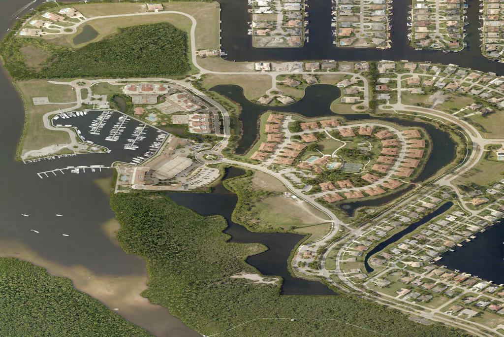
2 May 5, 2016 PDP Page 2 DESCRIPTION OF THE SUBJECT PROPERTY Tarpon Point is a mixed-use Planned Development Project (PDP). Tarpon Point was originally approved by Ordinance 14-01, and has subsequently been amended by Ordinances , 1-07, and This development consists of five multi-family village tracts (Villages A, B, D, E and F ), 47 singlefamily residential building sites, a common area tract (Village C ), two commercial tracts (Marina Villages 1 and 2), two conservation tracts, and three tracts utilized for private streets. Tarpon Point has been approved for 929 multi-family units, 47 single-family units, 45,000 square feet of retail/office space, 500 restaurant seats, and 268 hotel rooms. The conversion of the hotel located in Marina Village 1 to a compound use building allowing both hotel/motel and multi-family uses in the same building was approved by Ordinance This PDP amendment approves a three-story conference center on Marina Village 1, a parking lot and accompanying access road located on the Phase I area of Village A, and the development of 170 multifamily units located on the Phase II area of Village A (see Figure 1 below). This PDP amendment also approves an increase in the number of hotel rooms located on Marina Village 1 from 268 to 308, and eliminates an off-site paving requirement pertaining to Pelican Boulevard. Figure 1. The Tarpon Point Development highlighting the location of the Marina Village 1 and Village A Tracts that are involved with this PDP Amendment.
3 May 5, 2016 PDP Page 3 PREVIOUSLY GRANTED ENTITLEMENTS ASSOCIATED WITH THE PROJECT The Tarpon Point Development was originally approved by Ordinance Subsequently, this project has been amended three times by Ordinances , 1-07, and Entitlements granted associated with each of these four ordinances are briefly summarized below. Ordinance approved a mixed-use project entitled Tarpon Point. This PDP approved a subdivision with five multi-family village tracts (Villages A, B, C, D, and E), 44 single-family residential building sites (Village C), two commercial tracts (Marine Villages 1 and 2), three preservation area tracts (Conservation Areas 1, 2a, and 2b), and common areas for ingress and egress, drainage, and buffers. The project consisted of acres located between Rose Garden Road and the Caloosahatchee/Glover Bight and was granted a 10-year build-out period. Within this PDP, the following approvals were granted: Subdivision; Rezonings; Special exceptions uses; Deviations to the City s Land Use and Development Regulations (LUDRs); Deviations to the City s Engineering and Design Standards (EDS); and, Development Plan. This project was approved with the following residential densities and commercial intensities with respect to certain tracts as indicated below: Village A : a maximum of 220 multi-family units; Village B : a maximum of 120 multi-family units; Village C : a maximum of 44 single family units; Village D : a maximum of 128 multi-family units; Village E : a maximum of 232 multi-family units; Village F : a maximum of 232 multi-family units; Marina Village 1: approval of a marina use; and, Marina Village 2: approval of a maximum of 230 resort hotel units, two restaurants of not more than 200 seats each, and 45,000 sq. ft. of retail space. Ordinance granted the following approvals: Rezonings; Special exception uses; Deviations to the LUDRs; Repeal of a deviation of 82 feet that allowed a building height of 120 feet in Village A ; and, Amending the Development Plan with respect to locations of densities of uses as follows: o Village A : a maximum of 132 multi-family units; o Village B : a maximum of 120 multi-family units; o Village C : a maximum of 47 single family units: o Village D : a maximum of 210 multi-family units; o Village E : a maximum of 326 multi-family units; and, o Village F : a maximum of 140 multi-family units. Ordinance also approved allowing the number of multi-family units within the five multi-family village tracts to be reallocated without incurring a substantial deviation from the terms of the
4 May 5, 2016 PDP Page 4 development order provided that the number of multi-family units within any such village was not increased by more than 5%, and that in no event would the total number of dwelling units within the project area for the Tarpon Point PDP exceed 976 dwelling units. Ordinance 1-07 granted the following approvals: Relocating the previously approved hotel from Marina Village 2 to Marina Village 1; Increasing the maximum resort hotel units from 230 to 268; Allowing restaurants previously approved for Marina Village 2 to be located in Marina Village 1 or Marina Village 2; Eliminating a maximum of two restaurants; Increasing the maximum seating for all restaurants to 500 seats with one restaurant having at least 150 seats; and, Allowing the maximum of 45,000 sq. ft. of retail space previously approved in Marina Village 2 to be the maximum allowed as retail or office space in both Marina Village 1 and Marina Village 2, with at least 50% of such space located in Marina Village 1. Ordinance granted the following approvals: Increasing the project area by 13.5 acres by including submerged lands; Special exception uses; Deviations to the LUDRs involving parking standards; and, Conversion of the hotel in Marina Village 1 to a compound use building to allow multi-family dwelling units within a portion of the building. NEED FOR THE PDP AMENDMENT Once a development plan has been approved, any owner-initiated rezoning for any property within the approved development plan requires a PDP amendment. In addition, any substantial deviation from an approved development plan requires a PDP amendment as well (refer to LUDR, Section A.3). DESCRIPTION OF THE PROPOSED PROJECT Except for eliminating an off-site street improvement, this PDP amendment involves only the Marina Village 1 and Village A of the Tarpon Point Project. Within Marina Village 1, changes to the master development plan are proposed to expand the existing hotel to include a conference center on an existing parking lot near the northern end of this Village. Two foundation landscaping deviations are sought from planting requirements associated with the conference center. Within this Village, the Developer also requests increasing the number of hotel rooms from 268 to 308. The Developer seeks to rezone the 7.71-acre Village A Tract from the Multi-Family Residential (R-3) to the Pedestrian Commercial (C-1) District. Proposed changes to the Master Site Plan involving Village A show two separate phases. Phase 1 involves developing the western 3.25 acres of this Village into a parking lot containing 105 parking stalls for supporting hotel, including conference center activities and events. A landscape deviation is sought from a buffer yard requirement for allowing an existing hedge to remain in place that would be augmented with additional plantings.
5 May 5, 2016 PDP Page 5 SUMMARY OF APPLICANT REQUESTS Developer requests associated with this project along with the accompanying staff recommendation is summarized in Table 1. A thorough analysis of each request is provided later within a separate section of this report. Table 1. Summary of applicant requests and staff recommendations for the Tarpon Point PDP Amendment. Category Request Recommendation Rezoning Rezone Tract A from R-3 to C-1. Approve Deviation #1, LUDR, Section C.1 Deviation of 1,309 sq. ft. to the minimum foundation planting area requirement of 3,239 sq. ft. for the Marina Approve Deviation #2, LUDR, Section C.1 Deviation #3, LUDR, Section C.5, Table 5 PDP Amendment Village 1 Tract Deviation of 1.5 feet to the minimum spacing requirement of three feet on centers for shrubs planted in a foundation landscaped area to allow shrubs to be planted 4.5 feet apart within Marina Village 1 Deviation to waive all buffer requirements for the west property line of Village A adjacent to Silver King Boulevard. Approve Approve with conditions Eliminate an off-site paving requirement for Pelican Approve Boulevard PDP Amendment Increase the number of hotel rooms for Marina Village 1 Approve PDP Amendment Amend the Master Development Plan Approve with conditions A) Rezoning Request The Developer requests rezoning Tract A from the R-3 to the C-1 District. This rezoning is sought to allow the construction of a drive isle and commercial parking lot on the western side of this parcel for an area identified as Phase 1 as shown on the Master Site Plan (Parking Lot). These parking facilities will support activities occurring at the hotel and conference center. Located on the eastern side of Tract A, the Phase 2 area is envisioned to be developed with one or more residential or compound use buildings. Analysis The Planning Division has reviewed this application based on the ten (10) General Standards provided within LUDR, Section B and offers the following analysis for consideration: 1. The extent to which the value of the property is diminished by the proposed zoning of the property; While difficult to quantify, the requested rezoning should increase the value of the subject parcel as the C-1 District supports a variety of office, retail, and commercial service uses. Over 90 nonresidential uses are allowed either as permitted or as special exception uses in this district. In addition, with the Mixed Use Future Land Use (FLU) Classification of the subject property, the C-1 District allows multi-family development at a maximum density
6 May 5, 2016 PDP Page 6 greater than that allowed under the current R-3 Zoning. Generally, commercial properties command a greater price per square foot than residential lands, and property values tend to increase as the number of uses that can be utilized on a property increase. 2. The extent to which the removal of a proposed change in zoning depreciates the value of other property in the area; The subject parcel is located within the Tarpon Point Development that is a mixed-use community. This project has been approved for 929 multi-family units, 47 single-family units, 45,000 sq. ft. of retail/office space, 500 restaurant seats, and 268 hotel rooms. Residents that live in Tarpon Point that would likely be the most affected by the subject rezoning based on their proximity to this parcel, have presumably bought property in this community with the knowledge that this project supports both residential and commercial uses. Within the development, the nearest residential units are located to the north of the subject parcel across Silver King Boulevard about 100 feet from Tract A. Besides the physical separation that exists between these residences and the subject tract that is afforded by Silver King Boulevard, a mature, six-foot tall hedge exists along the north property line of Tract A that follows this street. The western part of Tract A will be developed as a parking lot to support the hotel and the proposed conference center. The eastern portion of this tract, located farthest from the residential community could be developed with residential or commercial uses or a combination of these two categories. Given the history and nature of Tarpon Point, the development proposed for Tract A, and the type and proximity of the surrounding uses, the proposed C-1 Zoning and the corresponding removal of the R-3 Zoning of the subject parcel should not result in a depreciation in the value of other properties in the area. 3. The suitability of the property for the zoning purpose; The subject property has a FLU Classification of Mixed Use. Based on Policy 1.15c of the FLU Element of the City s Comprehensive Plan, the proposed C-1 District is consistent with this FLU classification. The subject parcel is 7.71 acres, and based on the area and configuration of this property, could support a quality development as adequate area exists for supporting one or more buildings in additional to parking, landscaping, and stormwater facilities. The proposed C-1 Zoning provides the Developer with a high degree of flexibility in developing this tract. While the current R-3 District supports residential development, this District allows a limited number of nonresidential uses. In contrast, the proposed C-1 District, with the Mixed Use FLU Classification allows multi-family and compound use development. This District also allows a wide array of commercial uses including retail, restaurant, and office uses uses that are not allowed in the R-3 District. 4. The character of the neighborhood, existing uses, zoning of nearby and surrounding properties, and compatibility of the proposed zoning; The subject property is surrounded on three sides with parcels with R-3 Zoning while the fourth property located to the east has Preserve Zoning (see Table 2). However, of these three R-3 properties, only the parcel to the immediate west is developed with residential uses, and those dwelling units are separated from the subject property by Silver King Boulevard. The R-3 Zoned parcel to the immediate north of the subject property supports a
7 May 5, 2016 PDP Page 7 ROW tract that includes the gate house at the entrance to Tarpon Point. The R-3 Zoned parcel to the immediate south of the subject property is a lake tract located between the subject parcel and the conference center site. The Developer s plan includes constructing a pedestrian bridge for providing access from the parking lot proposed for the subject property to the hotel conference center. The Phase 2 area of the subject parcel could be developed with a maximum of 170 residential units and this use would be compatible with the surrounding properties. Table 2. Zoning, FLU, and Existing Uses of the Subject Parcel and Adjacent Lands. Subject Zoning Future Land Use Existing Uses Property: Current: Multi-Family Residential (R-3) Mixed Use Vacant Proposed: Pedestrian Commercial (C-1) No proposed change Parking lot Surrounding Zoning Surrounding Future Land Use Surrounding Uses North: Multi-Family Residential (R-3) Mixed Use Private ROW Tract South: Multi-Family Residential (R-3) Mixed Use Lake Tract East: Preserve Natural Resources/Preservation Water and open space West: Multi-Family Residential (R-3) Mixed Use Silver King Boulevard ROW/multi-family units In consideration of the above analysis, based on the current FLU and zoning patterns near the subject site, established uses in this area, and the area of the parcel proposed for rezoning, staff finds that the requested rezoning will be compatible with the neighboring properties. 5. The relative gain to the community as compared to the hardship, if any imposed, from rezoning said property; Staff does not envision any hardship experienced by the surrounding neighborhood as this rezoning will support uses that are consistent with the vision and current development of Tarpon Point as a mixed-use community. 6. The community need for the use proposed by the zoning; This rezoning will support the development of a commercial parking lot for providing over 100 parking spaces for the hotel and the proposed conference center. The C-1 District will also provide greater flexibility in developing the reminder of Tract A as this zoning designation will support residential, commercial, and compound use development compared to the more limited development options available with the current R-3 Zoning. 7. Length of time the property proposed to be rezoned has been vacant, as zoned, when considered in the context of the City of Cape Coral Comprehensive Land Use Plan for the development of the proposed property and surrounding property; The subject property has not been previously developed and to this point has had R-3 Zoning.
8 May 5, 2016 PDP Page 8 8. The extent to which the proposed zoning promotes the health, safety, morals, or general welfare of this community; The proposed rezoning will support the development of a commercial parking lot on Tract A that will provide parking to the hotel and adjoining conference center. The conference center should be an asset to the City as the Cape Coral currently lacks a facility of this size for accommodating conferences and large meeting functions. 9. The extent to which the proposed zoning will impact the level of service standards for public facilities as specified in the Comprehensive Plan; The full suite of centralized utilities (potable water, sewer, and irrigation) is available to the subject parcel. Besides supporting parking for the Tarpon Point Development, while this PDP amendment approves the development of a maximum of 170 residential units for Tract A, since the total number of multi-family units for the Tarpon Point Development remains unchanged at 929 units, transportation level of service standards and school concurrency will be unaffected by this rezoning. 10. Whether the proposed zoning is consistent with the City of Cape Coral s Comprehensive Land Use Plan. Recommendation Both the current R-3 Zoning as well as the proposed C-1 Zoning of the subject parcel is consistent with the City s FLU classification of Mixed Use. Based on the above analysis, the Planning Division recommends approval of this rezoning request. B) Landscaping Deviations Requested to the LUDRs Background LUDR, Section addresses deviations requested to the City s landscaping regulations. Such requests may be approved by the City Council provided the deviation will not be contrary to the public interest and will be in harmony with the general intent and purpose of this section and where either of the following applies: 1. Conditions exist that are not the result of the applicant and which are such that a literal enforcement of the regulations involved would result in unnecessary or undue hardship; or, 2. Literal conformity with the regulations would inhibit innovation or creativity in design. LUDR, Section B states In determining whether a particular deviation request should be approved as the result of unnecessary or undue hardship, factors the City Council shall consider include, but are not limited to, the following: site constraints such as shape, topography, dimension, and area of the property, the effect other regulations would have on the proposed development, or other locational factors
9 May 5, 2016 PDP Page 9 that may make compliance with this section impossible or impracticable, and the effect the requested deviation would have on the community appearance. Additionally, the the City Council shall find that the approval of the deviation(s) would serve the intent of this section to protect the health, safety, and welfare of the public while ensuring a high level of overall aesthetic appeal and visual interest in the City. LUDR, Section C states In determining whether a particular deviation request should be approved because literal conformity with the regulations would inhibit innovation or creativity in design, the City Council may approve the request for deviation(s) if the applicant demonstrates that the design of the landscaping for which one or more deviations is sought is unique and innovative and, further, that the approval of the deviation(s) would enhance such unique and innovative design. Additionally, the City Council shall find that the approval of the deviation(s) would serve the intent of this section to protect the health, safety, and welfare of the public while ensuring a high level of overall aesthetic appeal and visual interest in the city. For purposes of this section, indicia of unique and innovative design may include, but are not limited to, the following: 1. Landscape details that are unique or that are exceptional in quality by virtue of artistic composition, quality of materials, dimensional attributes, or any combination thereof; 2. Plant massing that evokes exceptional expression through use of angularity, curvature, or other means; 3. Design elements or other forms that achieve dynamic or symmetric aesthetic balance; or 4. Other details or forms that preclude visual monotony and are pleasing in aesthetic character. Request The applicant has requested a total of three landscaping deviations. Two deviations have been requested on the basis that the literal conformity with the regulations would inhibit innovation or creativity in project design. Staff has analyzed these two requests together, identified below, since both requests pertain to foundation landscaped areas, involve the same project area, and the justification provided by the applicant is the same. 1. A deviation of 1,309 sq. ft. to the minimum foundation landscaped area requirement of 3,239 sq. ft. pursuant to LUDR, Section C.1, for the Marina Village A deviation of 1.5 feet to the minimum spacing requirement of 3 feet on centers for shrubs planted in a foundation landscaped area pursuant to LUDR, Section C.1, to allow shrubs in foundation landscaped areas to be planted 4.5 feet apart within Marina Village 1. Analysis Are landscaping details present that are unique or that are exceptional in quality by virtue of artistic composition, quality of materials, dimensional attributes, or any combination thereof? Based on a conversation with the applicant, the approaches to the conference center have been intentionally designed to provide for expansive, open areas for encouraging gathering and socializing that will provide a seamless transition as one enters the interior of the conference center. Flexibility in incorporating foundation landscaped areas into this redevelopment project is also somewhat limited, particularly to the west of the conference center as much of this area will be occupied by a drive isle that includes a porte cochere.
10 May 5, 2016 PDP Page 10 Most importantly, the current project intends to build on an earlier landscaping theme established when the hotel was constructed in The existing landscaping has a tropical theme with an emphasis on palms, and including flowering plants and ground covers. The utilization of palms integrated with flowering plants, ground covers, as well as shrubs in evident in the landscaped center of the existing round-about located to the west of the proposed conference center. The Developer intends to provide palms, flowering plants, and ground covers within the foundation landscaped areas for providing consistency in landscaped areas. However, changes to the City s landscaping regulations that did not exist at the time Tarpon Point was originally approved in 2001, include requiring shrubs in foundation landscaped areas, spaced at a maximum of three feet on centers. To provide continuity between the landscaping installed several years ago with the newly proposed landscaping, the Developer seeks to install a combination of palms, shrubs, flowering plants, and ground covers in these foundation areas. Since the desired palms, flowering plants, and ground covers can occur only at the expense of the required shrubs, a deviation has been sought. Staff finds that the extension of the landscaping theme that has a tropical emphasis, will provide a combination of plantings that are exceptional by virtue of the variety of the landscaping materials employed, adding color by incorporating flowering plants into foundation areas, and providing plants with a variety of heights, ranging from groundcovers to palms. Is plant massing present that evokes exceptional expression through use of angularity, curvature, or other means? The utilization of plants exhibiting a wide range of heights occupying the foundation landscaped areas that will include groundcovers, shrubs, flowering plants, and palms that will create a visual, vertical layering effect that incorporates an exceptional landscaping expression into the project. Design elements or other forms present that achieve dynamic or symmetric aesthetic balance? Dynamic or symmetric aesthetic balance will be achieved in two ways. First, the deviation will allow for a good balance of a variety of different types of plants as opposed to foundation landscaped areas that feature mainly shrubs. Secondly, the height of the palms juxtaposed against the height of the three-story conference center will provide landscaping that is more visually balanced, given the height of this building. Are other details or forms present that preclude visual monotony and are pleasing in aesthetic character? The proposed landscaping plan that continues an existing landscaping theme for the Tarpon Point Development emphasizing tropical plantings, will contribute to a visually interesting project. Aesthetic interest will be created by providing a wide variety of different plantings in the foundation areas, the incorporation of color in these areas through the utilization of flowering plants, and incorporating plantings with a wide range of heights. The reduction in the area of the foundation landscape beds will contribute to a more expansive, open atmosphere anticipated to be experienced by visitors approaching the conference center. Recommendation Staff recommends approval of both requested deviations. Request
11 May 5, 2016 PDP Page 11 A deviation to LUDR, Section C.5, Table 5, that provides minimum requirements for a Buffer C to waive all buffer requirements for the west property line of the Village A adjacent to Silver King Boulevard. Analysis Staff has analyzed this request on the basis of a hardship. Are there site constraints such as shape, topography, dimensions and area of the property? A Buffer C requires a 15-foot wide landscaped area with a wall, or a 25-foot wide landscaped area with no wall required. Tract A consists of 7.71 acres and has an existing landscaped area that contains a buttonwood hedge with a height of about six feet. Several sabal palms are also present. The Developer proposes to leave the existing hedge in place and plans to add about 34 canopy trees to this buffer. The buffer will have a width ranging from 25 feet to about 45 feet. However, this buffer will lack accent trees and will likely be deficient in the number of shrubs to comply fully with the Buffer C requirements. This hedge was originally approved and installed under a set of landscaping requirements that were later substantially revised in The width of the landscaped area is sufficient to comply with the current landscaping regulations. While some trees are present within this buffer, the majority of the landscaping consists of a hedge comprised of green buttonwoods. This hedge is dense, appears healthy, and has a uniform height of about six feet. Compliance with the existing landscaping regulations would require accent trees to be integrated into the buffer at prescribed intervals that could prove difficult without affecting the integrity of the existing hedge or altering the aesthetics of this mature landscaping. Are other regulations present in this situation that would affect the proposed development or other locational factors that may make compliance with this section impossible or impractical? Other factors are present that make compliance with the required buffer yard impractical. Landscaping to the immediate east of Silver King Boulevard was installed on Village A about ten years ago. When this area of Tarpon Point was developed, Village A and the lands to the immediate west of the subject tract all had R-3 Zoning, and therefore no buffer yard was required. However, the C-1 zoning proposed for Village A now requires a Buffer C along the western property line of the Tract that is occupied by the existing hedge. The requested change in zoning is triggering the new buffer requirement for Tract A despite the presence of the hedge that is already present and has reached maturity. What effect would the requested deviations would have on community appearance? The requested deviation should have a negligible effect on community appearance. The existing row of shrubs is being maintained at a height of about six feet. This hedge is dense and provides good screening. Thirty-four additional canopy trees will be planted within this buffer area to provide added height and canopy cover along this area adjacent to Silver King Boulevard. Would the deviation protect the health, safety, and welfare of the public while ensuring a high level of overall aesthetic appeal and visual interest in the City?
12 May 5, 2016 PDP Page 12 The existing row of shrubs is mature and is being maintained at a height of six feet. This hedge is dense and provides little, if any opacity. The residential development located across Silver King Boulevard to the west is located within a gated community and therefore is somewhat isolated from other development activities occurring within Tarpon Point. This existing hedge should be adequate for screening activities on the subject property in the short term that will consist of surface parking supporting the hotel and new conference center. Additional trees will be added along this buffer to provide a greener, more layered appearance to this landscaped area. Recommendation Staff recommends approval of this deviation. A condition appears in the development order of this project requiring the existing hedge to be maintained at a height of six feet for the life of this project. C) Amendments to the Project Request Eliminating an off-site paving requirement for Pelican Boulevard. Background Ordinance included a condition requiring the Developer to overlay Pelican Boulevard from El Dorado West to Cape Coral Parkway West with asphalt at least one inch in thickness and to re-stripe this same area as a four-lane roadway at the end of the construction period. Resolution , adopted by the City Council on December 14, 2015, released the Developer from this paving obligation to assist in supporting the development of a conference center at Tarpon Point. A related Economic Development Incentive Agreement between the City and the Developer required the Developer to amend the PDP to remove the paving requirement from the project development order. Analysis The development order associated with this PDP amendment contains a provision under Section III., B. Transportation, which eliminates the repaving requirement previously borne by the Developer. The language contained within this PDP amendment is consistent with both Resolution and the Economic Development Incentive Agreement regarding the elimination of this off-site improvement. Recommendation Staff recommends approval of this request. Request Increasing the number of hotel rooms approved for the Marina Village 1 Tract. Background
13 May 5, 2016 PDP Page 13 The applicant seeks increasing the number of rooms in the hotel from 268 to 308. The hotel currently includes several floors that have two suites that are internally connected with a door. These suites are typically utilized by groups of people, like families, traveling together that wish to share hotel space but require separate sleeping areas. These joined suites were originally counted as single rooms during the review and permitting process and apparently have only one door leading to a common hallway. The Developer plans to renovate these rooms by eliminating the internal door connecting these two living areas and provide a second, separate door leading to the hallway. These renovations will result in each room having access to the hallway with the internal connection no longer existing between these adjacent rooms. Analysis The parking schedule provided to staff shows that the increased parking demand associated with the increased number of hotel rooms has been accounted for and incorporated into the project by the Developer. The increase in the number of rooms will not result in an increase to the building footprint of the hotel nor a change in the area of any existing floors. Changing the configuration of the existing rooms to increase the overall numbers of rooms in the hotel will assist this establishment in providing more rooms for visitors attending events held at the conference center. Recommendation Staff recommends approval of this request. Request Amend the Master Development Plan for the Tarpon Point Project. Background The Developer proposes to amend the master development plan by seeking approval of the following: 1. The expansion of the hotel on Marina Village 1 to include a conference center; 2. The development of Village A in two phases with the Phase I area supporting the construction of a surface parking lot to support the hotel facilities; and, 3. The development of a maximum of 170 residential units within the Phase II area of Village A. Analysis The Developer seeks approval of a conference center, with an estimated area of 40,000 sq. ft., which will be located on Marina Village 1. This facility will be located to the immediate northwest of the hotel. Parking for the hotel and conference center will be provided in the existing parking garage also located on Marina Village 1, with additional surface parking to be constructed on Tract A. Staff has reviewed the parking calculations provided by the Developer for the hotel and conference center and has found the parking proposed by the Developer complies with the LUDRs for the planned mix of uses. The rezoning of Village A will also support the development of a multi-family residential or mixed-use development on the Phase 2 area. A maximum of 170 residential units could be constructed on this Tract, however, the total number of multi-family units (929) previously approved for the entire Tarpon Point
14 May 5, 2016 PDP Page 14 Development will not be exceeded. When the Phase 2 area is developed, parking will need to be provided to support those uses occupying the Phase 2 area. Recommendation Staff recommends approval of all requested changes to the master development plan. The Economic Development Incentive Agreement between the Developer and the City requires the Developer to provide a conference center of no less than 35,000 sq. ft., and a surface parking lot at Tarpon Point. Staff has included a condition in the development order requiring the conference center to have a minimum gross floor area of 35,000 sq. ft. CONSISTENCY WITH THE CITY S COMPREHENSIVE PLAN This project is consistent with the following goals, objectives, and policies contained within the City s Comprehensive Plan: Housing Element GOAL: To provide good quality housing in safe, clean neighborhoods, offering a broad choice of options in both type (single family and multi-family) and tenure (owner and renter occupied) to meet the needs of present and future residents of the City, regardless of age or income status. Staff comment: The Tarpon Point Development offers a variety of different housing options including single-family and multi-family units. This development supports multi-family units in both free-standing residential buildings, and compound use buildings where these residential units may occur in conjunction with nonresidential uses. Future Land Use Element Policy 1.15.c The Pedestrian Commercial (C-1) District is designed to facilitate a broad variety of large or small commercial uses. Uses allowed in the C-1 District range from a variety of small or neighborhood-based commercial uses to larger retail or service uses, which may serve a relatively large trade area and, which may be developed as major shopping facilities... Staff comment: A rezoning from R-3 to C-1 is sought and recommended for Village A. This parcel has sufficient depth and area (7.71 acres) for supporting commercial uses. Since this parcel has a Mixed-Use FLU, this property can also support multi-family development. Policy 1.20: The City will promote the development of identifiable residential neighborhoods and commercial districts through the encouragement of more compact development patterns, the use of shared design and landscaping characteristics, and the development of landmarks and gateways. Staff comment: Tarpon Point is a mixed-use waterfront community. This development has entry features and fountains that provide distinctiveness to this project. Landscaping within this
15 May 5, 2016 PDP Page 15 development features tall palms and a variety of flowering plants that contribute to a tropical atmosphere within the community. Economic Development Element Policy 2.6: The City of Cape Coral shall develop and implement financial incentives designed to support the retention and expansion of existing businesses. Staff comment: Through the Economic Development Incentive Agreement that the City has executed with Freeman and Hasselwander Resort Properties, LLC, the City has agreed to remove an offsite paving requirement previously required of the Developer, and has agreed to pay a maximum of $200,000 for the impact fees related to the development of the conference center. PUBLIC NOTIFICATION This case was publicly noticed as required by LUDR, Section 8.3 as further described below. Publication: A legal ad was prepared and sent to the New Press for scheduled publication on May 8, 2016 and May 29, Written notice: Property owners located the Tarpon Point project as well as individuals owning property within 500 feet of the project were mailed letters during the week of May 2, 2016 advertising the project and public hearing dates. A total of 133 individuals owning property within the Tarpon Point Development received letters. An additional 334 individuals owning property outside, but within 500 feet of the Tarpon Point project area also received letters. Posting of a Sign: Signs were scheduled to be posted within the Tarpon Point project during the week of May 2, PROJECT RECOMMENDATION Staff finds that this PDP amendment, described within this report, is consistent with the City s LUDRs and Comprehensive Plan. Staff supports all requests made by the applicant and recommends approval of this PDP amendment subject to the conditions contained within the development order of this project. Staff Contact Information Mike Struve, AICP, LEED Green Associate, Planning Team Coordinator PH: mstruve@capecoral.net
16
17
18
19
20

21 PDP ORDINANCE AN ORDINANCE AMENDING ORDINANCE 14-01, AS AMENDED, WHICH APPROVED A PLANNED DEVELOPMENT PROJECT IN THE CITY OF CAPE CORAL, FLORIDA ENTITLED "TARPON POINT" FOR CERTAIN PROPERTY DESCRIBED AS A REPLAT OF A PORTION OF UNIT 77, CAPE CORAL, FLORIDA, AS PER THE PLAT RECORDED IN PLAT BOOK 34, PAGES 54 THROUGH 65, INCLUSIVE, PUBLIC RECORDS OF LEE COUNTY, FLORIDA AND A PARCEL OF SUBMERGED LAND LOCATED IN SECTION 22, TOWNSHIP 45 SOUTH, RANGE 23 EAST, AS MORE PARTICULARLY DESCRIBED HEREIN; PROPERTY LOCATED AT SILVER KING BOULEVARD, BLACK MARLIN LANE, AND TARPON ESTATES BOULEVARD; BY APPROVING REZONING OF TRACT "A" FROM MULTI-FAMILY RESIDENTIAL (R-3) TO PEDESTRIAN COMMERCIAL (C-l); GRANTING DEVIATIONS FROM THE CITY OF CAPE CORAL LAND USE AND DEVELOPMENT REGULATIONS, SECTION 5.2, LANDSCAPING; ELIMINATING AN OFF-SITE PAVING REQUIREMENT FOR PELICAN BOULEVARD; APPROVING AN INCREASE IN THE NUMBER OF HOTEL ROOMS FOR THE PROJECT; AMENDING THE MASTER DEVELOPMENT PLAN; GRANTING DEVELOPMENT PLAN APPROVAL PURSUANTTO SECTION 4.2 OF THE CITY OF CAPE CORAL LAND USE AND DEVELOPMENT REGULATIONS; PROVIDING FOR FINDINGS OF FACT AND CONCLUSIONS OF LAW;PROVIDING FOR ACTION ON REQUEST AND CONDITIONS OF APPROVAL; PROVIDING FOR LEGAL EFFECT AND LIMITATIONS OF THIS PDP DEVELOPMENT ORDER AND ADMINISTRATIVE REQUIREMENTS; PROVIDING SEVERABILITY AND AN EFFECTIVE DATE. WHEREAS, the "Tarpon Point" Planned DevelopmentProject was approved by the CityCouncilof the City of Cape Coral by Ordinance 14-01, as amended by Ordinance , Ordinance 1-07, and Ordinance 77-11; and WHEREAS, an application from Freeman and Hasselwander Resort Properties, LLC, has been received requesting amendment of the "Tarpon Point" Planned Development Project (PDP), including a rezoning of Tract "A," deviations to the Land Use and Development Regulations, and elimination of off-site pavingimprovements required in Ordinance 14-01; and WHEREAS, said application received is by parties holding tide to ownership of one hundred percent (100%) of the property included in the requested amendment; and WHEREAS, the request has been reviewed by the Cape Coral Planning and Zoning Commission/Local Planning Agency; and WHEREAS, the City Council has considered the recommendations of the Planning and Zoning Commission/Local PlanningAgency. NOW, THEREFORE, THE CITY OF CAPE CORAL, FLORIDA, HEREBY ORDAINS PURSUANT TO THE LAWS OF FLORIDA, AND OTHER APPLICABLE LAWS, THIS ORDINANCE: SECTION I. PDP APPROVAL, DEVIATION, REZONING, AMENDMENT TO DEVELOPMENT ORDER CONDITIONS, REVISIONS TO THE MASTER DEVELOPMENT PLAN. Having reviewed the application requesting approval of a Planned Development Project amendment for "Tarpon Point" PDP, requesting the following: The rezoning of Tract "A" from Multi-Family Residential (R-3) to Pedestrian Commercial (C-l); and Adeviation of 1,309 square feet to the minimum foundation planting area requirement of3,239 square feet pursuant tosection C.1 ofthe City ofcape Coral Land Use and Development Regulations for themarina Village 1 Tract to allow a foundation planting area of 1,930 square feet; and

22 A deviation of 1.5 feet to the minimum spacing requirement of3 feet on centers for shrubs planted in a foundation landscaped area pursuant to Section C.1 of the Cape Coral Land Use and Development Regulations to allow shrubs in this area to be planted 4.5 feet apart within the Marina Village 1 Tract; and A deviation to Section C.5, Table 5, of the City of Cape Coral Land Use and Development Regulations that provides minimum requirements for a Buffer "C" to waive all buffer requirements for the for the west property line of Village "A" Tract adjacent to Silver King Boulevard; Eliminating a condition in Ordinance 14-01, Section III.M.6, requiring the Developer to overlay Pelican Boulevard from El Dorado West to Cape Coral Parkway West with asphalt not less than oneinch in thickness and re-stripe said area as a four-lane roadway at the end of the construction period; Increasing the number of hotel rooms previously approved for the Marina Village 1 Tract from 268 to 308; Amending the Master Development Plan to approve the expansion of the hotel on Marina Village Tract 1 to include a conference center with a minimum area of 35,000 square feet; Amending the Master Development to approve the development of the Village "A" Tract in two phases, with the Phase I area approved for the development of a parking lot for supportingactivities occurring at the Conference Center, and the Phase II area approved for a maximum of 170 residential units, including parking and related improvements; and having considered the recommendations of the Planning and Zoning Commission and the Local Planning Agency, the City Council of the City of Cape Coral, Florida, does hereby grant the aforesaid PDP approval, and approve development plan in accordance with plan set, Sheets 1-10, dated November 18, 2015, and also bearing a revision date of March 28, 2016, prepared by Avalon Engineering, Inc., Sheets LA-1 and LA-2, and LA-3, dated February 23, 2016, prepared by Urban Green Studio, and Boundary and Topographic Survey, dated June 17, 2015, prepared by Stouten Cramer Professional Surveyors, dated June 17,2015. All aforementioned sheets appear in composite Exhibit A for purposes of development plan approval pursuant to Section 4.2 of the City of Cape Coral Land Use anddevelopment Regulations from thedate of adoption of this ordinance. Approval ofthe PDP shall be subject to the terms and conditions set forth below. SECTION II. FINDING OF FACT/CONCLUSION OF LAW A. The"Tarpon Point" development isa Mixed-Use Planned Development Project (PDP). This development consists of five multi-family Village tracts (Villages "A,""B,""D," "E" and"f"), 47 single-family residential building sites, a common area tract (Village "C"), two commercial tracts (Marina Villages 1 and 2), and two conservation tracts, and three tracts utilized for private streets. The Tarpon Point PDP approved 929 multi-family units, 47 single-family units, 45,000 square feet of retail/office space, 500 restaurant seats, and 268 hotel rooms. The hotel located in Marina Village 1 is approved for both hotel/motel andmulti-family uses in the same building. This PDP amendment approves expanding the existing hotel on Marina Village I to include a three-story conference center, and increasing the number of hotel rooms within the existing hotel from 268 to 308. The conference center will include, but is not limited to, banquet and meeting rooms, and kitchen and storage facilities. This amendment also approves a parking lot and accompanying access road located on the Phase I area of the Village "A" Tract, and the future development of a maximum of 170 multi-family units located on the Phase II area of the Village "A" Tract. This PDP amendment extends the buildout date for the Tarpon Point project for ten years from the date ofadoption of this PDP amendment. Project phasing for the Village "A" Tract is depicted on Sheet 6 of 10, entitled "Master Site Plan (Parking Lot)" and is summarized below. Phase I shall include: 1. Constructing the parking lot on Village "A" Tract for supporting the hoteland conference center located on Marina Village 1; and 2. Constructing the access road associated with the parking lot off Silver King Boulevard.

23 Phase II shall include: 1. Constructing the multi-family development consisting ofa maximum of170 dwellingunits with structured parking on Village "A" Tract; and 2. Completing the planting of any remaining trees needed to meet minimum landscaping requirements for the entire 7.71-acreVillage "A" Tract. The construction of the parking lot and access road associated with Phase I of this project shalloccur prior to the construction ofphase II or concurrentlywith the construction of Phase II. In no event shall a certificate of occupancy be issued by the City for a building located on the Phase II area prior to the completion of all Phase I improvements. B. The name(s) of the legal and equitable owner(s) are Freeman and Hasselwander Resort Properties, LLC. C. The legal description of the property subject to the extant PDP Development Order, that includes the submerged lands, is described in attached Exhibit B. D. The legal description of the portion of the property for which the Planned Development Project is being amended is described as follows: Tract MV-1 and Tract A, Block 7025, Tarpon Point, a replat of a portion of Unit 77, Cape Coral, Florida, as per the platrecorded in PlatBook 73, Pages 70 through 79,inclusive, Public Records of Lee County, Florida. E The City of Cape Coral Official Zoning District Map of all of the property within the limits of thecity of Cape Coral ishereby amended with respect to real property described as follows: Tract A, Block 7025, Tarpon Point, a replat of a portion of Unit 77, Cape Coral, Florida, as per the plat recorded in Plat Book 73, Pages 70 through 79, inclusive, Public Records of Lee County, Florida. by rezoning said property from MULTI-FAMILY RESIDENTIAL (R-3) to PEDESTRIAN COMMERCIAL (C-l) ZONE,and the City administrative office shall amend thecity ofcape Coral Official Zoning District Map to reflect this zoning change. That the amendment to the City of Cape Coral Official Zoning District Map as prescribed herein is consistent with the City of Cape Coral Comprehensive Plan. F. The "Tarpon Point" PDP property has acres zoned Pedestrian Commercial (C-l), acres zonedmulti-family Residential (R-3), acres zonedresidential Development (RD), and acres zoned Preservation (PRES) pursuant to the authority of Chapter 166, Florida Statutes, and the Land Use and Development Regulations, Cape Coral, Florida, as same may hereafter be amended. The subject property has approximately acres with a Future Land Use designation of Mixed-Use (MX) and acres with a future land use designation ofnatural Resources/Preservation. The Tarpon Point development contains tracts of land that total acres. In addition, the development contains an additional 13.5 acre parcel of submerged lands for a total project area of acres. G. All existing and future structures and uses, population density, building intensity, and building height shall conform to the respective provisions of the Pedestrian Commercial (C-l), Multi- Family Residential (R-3), Residential Development (RD), and Preservation (PRES) zoning districts of the Land Use and Development Regulations, Cape Coral, Florida, as same may hereafter beamended. In addition, the development shall obtain all local development permits from the City of Cape Coral, Florida, and other governmental jurisdictions. Failure of this agreement to address a particular permit, condition, term, restriction, or zoning regulation shall not relieve the Developer of the necessity of complying with the law governing said permitting requirements, conditions, terms, restrictions, or zoning regulations. H. The proposed development does not unreasonably interfere with the achievement of the objectives of the adopted State Land Development Plan applicable to the area.

24 I. The "Tarpon Point" PDP, as noted, is consistent with the adopted City of Cape Coral Comprehensive Plan, and the City ofcape Coral Land Use and Development Regulations. J. The term Developer for purposes ofthis development order shall mean and refer to Freeman and Hasselwander Resort Properties,LLC, its successors in interest, lessees, and/or assigns. SECTION III. ACTION ON REQUEST AND CONDITIONS OF APPROVAL NOW, THEREFORE, be it ordained by the City Council of Cape Coral, Florida, in public meeting duly advertised, constituted and assembled, that the Planned Development Project application for development approval submitted by Freeman and Hasselwander Resort Properties, LLC, is hereby ordained approved, subjectto the following conditions, restrictions, and limitations deemed necessary for the public health, safety, and welfare. A. WETLANDS, VEGETATION, AND WILDLIFE In the eventallor a portion of the subject property is located withinan EagleNest Management Zone, the developershall complywith all Citylaws, regulations, and guidelines that are currentlyin effect or that may be hereafter adopted by the City concerning the protection and management of bald eagle nestsincluding, but not limited to Chapter 23 of the City Code of Ordinances. No development shall occur on any portion of the subject property that is within an Eagle Nest Management Zone except in accordance with a Bald Eagle Management Plan that has been approved bythecity. Once an Eagle Management Planhas been approved by the City for all or a portion of the property, the Developer's ability to develop in accordance with such Plan shall not be affected by any amendment to the City's regulations concerning eagle nests, so long as no additional or "new" eagle nest need to be accommodated. In the event, however, that one or more eagle nests are hereafter established or determined to be active in locations that result in all or a portion of the subject property being located in a new or expanded Eagle Nest Management Zone, then no development shall occur in such new zone except in accordance with an Eagle Management Plan that has been approved by the City for such zone. B. TRANSPORTATION This PDP amendment eliminates a provision in Ordinance requiring the Developer to overlay Pelican Boulevard from ElDorado Parkway West tocape Coral Parkway West with asphalt notless than one-inch in thickness and to re-stripe said area as a four-lane roadway at the conclusion of construction activities. C. GENERAL CONSIDERATIONS 1. All provisions and conditions contained in the "Tarpon Point" PDP asapproved by Ordinance and amended by Ordinances , 1-07, and 77-11, shall remain in full force and effect, except as otherwise stated in this Development Order. 2. Prior toissuance of a permit, the Developer shall enter into anagreement, in a form acceptable to the City Attorney, regarding obligations resulting from landscaping located in utility easements. 3. The Developer shall maintain the existing landscape buffer along the northern property line of Village "A" Tract, adjacent to and south of Silver King Boulevard. The shrubs within this buffer shall be maintained at a minimum height of six feet for the life of the project. Shrubs that die or are removed shall bereplaced with a shrub of the same species having a minimum height of32 inches. Trees that die orare removed shall be replaced with acanopy tree having a minimum caliper at least equal to that of the removed tree; however, if the caliper of the removed tree isgreater than four inches (measured at a height of 12inches above theground), the replacement tree shall be required to have a minimum caliper of four inches. 4. The Phase 2 area of the Village "A" Tract as depicted on Sheet 6 of 10 entitled "Master Site Plan (Parking Lot)" may be developed with a maximum of 170 multi-family residential units without requiring a PDP amendment unless the project contains a request that necessitates a PDP.
25 5. The conference center associated with the hotel located on Marina Village I shall have a rninimum gross floor area of 35,000 square feet. Besides meeting rooms and conference facilities, this area may include space devoted to food preparation and storage, and other ancillary purposes. D. CONCURRENCY The "Tarpon Point" PDP is concurrent for roads, sewer, water, drainage, solidwaste, and parksbased on the analysis of the proposed developmentand specific mitigation programs specified herein. SECTION IV. LEGAL EFFECT AND LIMITATIONS OF THIS DEVELOPMENT ORDER, AND ADMINISTRATIVE REQUIREMENTS A. This Development Order shall constitute an ordinance of the City of Cape Coral, adopted by this Council in response to the Planned Development Project Application filed for the "Tarpon Point" PDP. B. This Development Order shall be binding on the Developer. Those portions of this Development Order which clearly apply only to the projectdeveloper, shall not be construed to be binding upon future owners of the project lots. It shall be binding upon any builder/developer who acquires any tract of land within the PDP. C. The terms and conditions set out in this document constitute a basis upon which the Developer and City may rely in future actions necessary to implement fully the final development contemplated by this Development Order. D. All conditions, restrictions, stipulations, andsafeguards contained in this Development Order may be enforced by either party hereto by action at law or equity, and all costs of such proceedings, including reasonable attorney's fees, shall be paid by the defaulting party. E. Any references herein to any governmental agency shall be construed to mean to include any future instrumentality whichmay be created and designated as successor in interestto or which otherwise possesses any of the powers and duties of any referenced governmental agency in existence on the effective dateof this Development Order. F. The approval granted by this Development Order is limited. Such approval shall not be construed to obviate the duty of the Developer to comply with all applicable local or state review and permitting procedures, except where otherwise specifically provided. Such approval shall also not obviate the duty of the Developer to comply with any City Ordinance or other regulations adopted after the effective date of this Development Order. G. Subsequent requests for local development permits shall not require further review, unless it is found by the City Council, after due notice and hearing, that one or more substantial deviation(s), or other changes to the approved development plans which create a reasonable likelihood of adverse impacts which were not evaluated in the review by the City have occurred. Substantial deviations include but are not limited to: 1. Any change which requires a variance to code and above those specifically incorporated herein. 2. An increase of more than five (5) percent in density, parking requirements, trip generation rates, water or sewer usage, or building square footage. 3. An expiration of the period of effectiveness of this Development Order as herein provided. 4. If development order conditions and applicant commitments incorporated within the Development Order to mitigate impacts are not carried out as indicated to the extent or in accordance with the Development Order, then this shall be presumed to be a substantial deviation from the Development Order. Upon a finding thatany of the above is present, the City Council may ordera termination of all development activity until such time as anew PDP Application for Development Approval has been submitted, reviewed andapproved, and all local approvals have beenobtained.
26 H. The physical development authorized under this Development Order shall terminate in ten years from the date ofadoption of this Development Order, unless an extension is approved by this Council. The Council may grant an extension if the project has been developing substantially in conformance with the original plans and approved conditions, and if no substantial adverse impacts not known to Cape Coral at the time of their review and approval, or arising due to the extension, have been identified. For purposes of determining when the buildout date has been exceeded, the time shall be tolled during the pendency ofadministrative and judicial proceedings relating to development permits. All conditions imposed on the subject development shall remain in full force and effect throughout the life of the development unless rescinded or amended by the City and shall not be affected by any termination of the authorization for physical development. I. The Director of the Cape Coral Department of CommunityDevelopment or his/her designee, shall be die local official responsible for assuring compliance with this Development Order. Upon reasonable notice by the City and at all reasonable times, the Developer shall allow the City of Cape Coral, its agents, employees, and/or representatives, access to the project site for the purpose of assuring compliancewith this Development Order. J. This Development Order shall be recorded with the Office of the Lee County Clerk of Court by the City of Cape Coral. The Developer shall be responsible for reimbursing the City for all recording fees within 30 days of being notified by the City that die Development Order has been recorded. SECTION V. SEVERABILITY. In the event that any portion or section of this Ordinance is determined to be invalid, illegal, or unconstitutional by a court of competent jurisdiction, such decision shall in no manner affect the remaining portions or sections ofthis Ordinance which shall remain in full force and effect. SECTION VI. EFFECTIVE DATE. This Ordinance shall take effect immediately upon its adoption by die Cape Coral City Council. Permits issued prior to or after the effective date of this Ordinance are obtained solely at the risk of the Developer. ADOPTED BY THE COUNCIL OF THE CITY OF CAPE CORAL AT ITS REGULAR SESSION THIS DAY OF, MARNI L. SAWICKI, MAYOR VOTE OF MAYOR AND COUNCILMEMBERS: SAWICKI BURCH CARIOSCIA STOUT LEON ERBRICK WILLIAMS COSDEN ATTESTED TO AND FILED IN MY OFFICE THIS DAY OF APPROVED AS TO FORM: REBECCA VAN DEUTEKOM, CITY CLERK BRIANTCBARTOS ASSISTANT CITY ATTORNEY ord/pdpl Tarpon Point Amendment
27 P:\CAD\2015\15-491\PDP-AMENDMENT_PHASE-ONE\PLOT_PHASE-ONE\15-491_cover.dwg, Layout1, 3/28/ :30:20 AM, Avalon Engineering Inc.
28 P:\CAD\2015\15-491\PDP-AMENDMENT_PHASE-ONE\PLOT_PHASE-ONE\15-491_AERIAL_FEMA-ZONES.dwg, Layout1, 3/28/ :30:30 AM, Avalon Engineering Inc.
29 TARPON ESTATES BLVD. CLE S CIR EN ARD TARPON ESTATES BLVD. ON G TARP P:\CAD\2015\15-491\PDP-AMENDMENT_PHASE-ONE\PLOT_PHASE-ONE\15-491_zoning.dwg, Layout1, 3/28/ :30:49 AM, Avalon Engineering Inc. Exhibit A TAR PON TARPON ESTATES CT. LV GB SIL IN RK VE D. GAR DEN S CIRC LE SIL R VE G KIN BL VD.
30 CLE S CIR TARPON ESTATES BLVD. RDEN N GA TARPON ESTATES BLVD. O TARP P:\CAD\2015\15-491\PDP-AMENDMENT_PHASE-ONE\PLOT_PHASE-ONE\15-491_current-development.dwg, Layout1, 3/28/ :31:05 AM, Avalon Engineering Inc. Exhibit A TAR TARPON ESTATES CT. GB SIL VE IN RK LV D. PON GAR DEN S CIR CLE GB SIL VE R KIN LV D.
31 SILVER KING BLVD. SILVER KING BLVD. P:\CAD\2015\15-491\PDP-AMENDMENT_PHASE-ONE\PLOT_PHASE-ONE\15-491_M_SITE-PLAN.dwg, CONF-CENTER, 3/28/ :31:30 AM, Avalon Engineering Inc. CURVE RADIUS DELTA ANGLE ARC LENGTH CHORD BEARING CHORD LENGTH C ' 37 47'07" ' S 50 52'44" W ' C ' 15 12'13" ' N 62 10'10" E ' C ' 67 11'03" ' N 88 09'36" E ' C ' '46" 49.15' S 34 21'35" E 41.00' C ' 78 29'55" 46.54' N 15 19'43" W 42.99' C ' 9 04'40" 42.78' S 70 39'43" E 42.73' C ' 61 59'07" 34.62' S 35 07'49" E 32.96' C ' '37" ' S 69 15'26" W ' LINE BEARING DISTANCE L1 N 20 18'24" E 42.41' L2 N 12 23'42" E 31.79' L3 S 76 55'32" W 35.18' L4 N 84 46'34" W 48.36' L5 N 57 38'51" E 19.53' L6 N 82 17'24" E 45.03' L7 N 88 59'43" W 35.22' L8 N 46 28'32" W 34.17' L9 N 36 07'33" W 19.35' L10 N 68 53'59" W 26.62' L11 S 80 05'53" W 28.20' L12 S 58 00'50" E 40.67' L13 N 69 54'52" E 40.94' L14 N 70 07'09" W 18.95' L15 S 68 21'37" E 21.95' L16 S 00 07'29" W 17.57' L17 N 30 10'59" E 31.32' L18 S 14 38'54" E 35.39' L19 N 00 09'18" E 28.48' L20 N 10 53'49" E 49.83' L21 N 02 09'00" W 66.77' L22 S 13 26'14" E 35.31' L23 N 74 41'03" E 1.17' L24 N 79 08'24" E 38.56' L25 S 86 28'20" W 20.52' L26 N 02 59'58" W 1.00' L27 S 05 38'56" W 3.08' L28 S 38 42'47" W 18.41' L29 S 62 15'58" W 2.50' L30 S 38 42'47" W 49.38' L31 N 16 46'03" E 48.12' L32 N 10 33'10" E 50.57' L33 N 64 17'30" E 34.71' L34 N 14 57'55" E 42.08' L35 S 30 15'57" E 49.50' L36 S 22 23'00" E 24.21' L37 N 10 34'39" E 26.81' L38 S 10 47'11" W 11.39'
32 P:\CAD\2015\15-491\PDP-AMENDMENT_PHASE-ONE\PLOT_PHASE-ONE\15-491_M_SITE-PLAN.dwg, PARKING, 3/28/ :31:35 AM, Avalon Engineering Inc. SILVER KING BLVD. CIRCLE GARDENS TARPON L5 N 57 38'51" E 19.53' L6 N 82 17'24" E 45.03' L7 N 88 59'43" W 35.22' L8 N 46 28'32" W 34.17' L9 N 36 07'33" W 19.35' L10 N 68 53'59" W 26.62' L11 S 80 05'53" W 28.20' L12 S 58 00'50" E 40.67' GARDENS CIRCLE TARPON SILVER KING BLVD.
33 P:\CAD\2015\15-491\PDP-AMENDMENT_PHASE-ONE\PLOT_PHASE-ONE\15-491_M_DRAINAGE-PLAN.dwg, CONF-CENTER, 3/28/ :31:59 AM, Avalon Engineering Inc. SILVER KING BLVD. SILVER KING BLVD.
34 P:\CAD\2015\15-491\PDP-AMENDMENT_PHASE-ONE\PLOT_PHASE-ONE\15-491_M_DRAINAGE-PLAN.dwg, PARKING, 3/28/ :32:05 AM, Avalon Engineering Inc. BLVD. R KING GARDENS CIRCLE TARPON GARDENS CIRCLE TARPON SILVER KING BLVD.
35 P:\CAD\2015\15-491\PDP-AMENDMENT_PHASE-ONE\PLOT_PHASE-ONE\15-491_M_UTILITY-PLAN.dwg, CONF-CENTER, 3/28/ :32:27 AM, Avalon Engineering Inc. SILVER KING BLVD. SILVER KING BLVD.
36 P:\CAD\2015\15-491\PDP-AMENDMENT_PHASE-ONE\PLOT_PHASE-ONE\15-491_M_UTILITY-PLAN.dwg, PARKING, 3/28/ :32:35 AM, Avalon Engineering Inc. BLVD. R KING GARDENS CIRCLE TARPON GARDENS CIRCLE TARPON SILVER KING BLVD.
37 Exhibit A
38 Exhibit A

39 Exhibit A 36

40 Exhibit A

41 Exhibit "B" TARPON POINT LEGAL DESCRIPTION: A REPLAT OF A PORTION OFUNIT 77, CAPE CORAL, TAPRON POINT ACCORDING TO PLAT BOOK 34, PAGES 54 THROUGH 65, OF THE PUBLIC RECORDS OF LEE COUNTY, FLORIDA, SITUATED IN SECTION 22, TOWNSHIP 45 SOUTH, RANGE 23 EAST, CITY OF CAPE CORAL, LEE COUNTY, FLORIDA. TRACTS 1, 2, 3, 4, 5, 6, 8, 9 AND 10, CAPE CORAL UNIT 77, TARPON POINT, ACCORDING TO THE PLAT THEREOF, AS RECORDED IN PLAT BOOK 34, PAGES 54 THROUGH 65 OF THE PUBLIC RECORDS OF LEE COUNTY, CITY OF CAPE CORAL, LEE COUNTY, FLORIDA, BEING MORE PARTICULARLY DESCRIBED AS FOLLOWS: BEGINNING AT THE NORTHWEST CORNER OF TRACT 9 OF SAID CAPE CORAL UNIT 77, BEING ALSO THE SOUTHWEST CORNER OF LOT 8, BLOCK 3443 OF CAPE CORAL UNIT 67 ACCORDING TO PLAT BOOK 25, PAGES 57 THROUGH 65, AND A POINT ON THE EAST RIGHT OF WAY LINE OF CASABA CANAL (200 FOOT RIGHT OF WAY); THENCE RUN N89 34'47'E ALONG THE NORTH LINE OF SAID CAPE CORAL UNIT 77, BEING ALSO THE SOUTH LINE OF SAID CAPE CORAL UNIT 67, FOR FEET TO THE SOUTHEAST CORNER OF LOT 1 OF SAID BLOCK 3443 AND THE SOUTHWEST CORNER OF ROSE GARDEN ROAD RIGHT OF WAY; THENCE CONTINUE RUNNING N89 34'47"E ALONG SAID NORTH LINE OF SAID CAPE CORAL UNIT 77, BEING ALSO THE SOUTH LINE OF SAID ROSE GARDEN ROAD RIGHT OF WAY, FOR FEET; THENCE RUN ALONG THE LINE COMMON TO SAID CAPE CORAL UNIT 77 AND SAID ROSE GARDEN ROAD RIGHT OF WAY FOR THE FOLLOWING FOUR COURSES: N00 25,13"W FOR FEET TO THE POINT OF CURVATURE OF A CURVE CONCAVE TO THE SOUTHEAST, THEN RUN ALONG SAID CURVE HAVING A RADIUS OF FEET AND A CENTRAL ANGLE OF '55" (CHORD=N62 56'44"E, FEET) FOR FEET TO THE POINT OF TANGENCY, THEN RUN SSS^l'lS^ FOR FEET TO THE POINT OF CURVATURE OF A CURVE CONCAVE TO THE NORTHWEST, THEN RUN ALONG SAID CURVE HAVING A RADIUS OF FEET AND A CENTRAL ANGLE OF 90 53'32" (CHORD=N80 51,56"E, FEET) FOR FEET TO THE NORTHEASTERLY CORNER OF SAID TRACT 6 OF SAID CAPE CORAL UNIT 77, BEING ALSO THE NORTHWESTERLY CORNER OF TRACT 7 (CITY PARK) OF SAID CAPE CORAL UNIT 77; THENCE RUN S01o03'10"W ALONG THE LINE COMMON TO SAID TRACT 6 AND SAID TRACT 7 FOR FEET TO AN INTERSECTION WITH THE MEAN HIGH WATER LINE AS DETERMINED BY THE WILSON MILLER SURVEY DATED ; THENCE RUN ALONG SAID MEAN HIGH WATER LINE THE FOLLOWING FIVE COURSES: S87 40'41'W FOR FEET, S77 19'11,W FOR FEET, S18 26,06"W FOR FEET, S87036'51"W FOR FEET, S74 41,03"W, FOR FEET TO A POINT ON THE EAST END OF AN EXISTING SEAWALL, THENCE RUN ALONG SAID EXISTING SEAWALL THE FOLLOWING TEN COURSES: N85o20'05"W FOR FEET, S79 08'24"W FOR FEET, S79o06'04"W FOR FEET, S86 28'20"W FOR FEET TO THE NON-TANGENT POINT OF CURVATURE OF A CURVE CONCAVE TO THE NORTHEAST, THEN RUN ALONG SAID CURVE HAVING A RADIUS OF FEET AND A CENTRAL ANGLE OF MTWW (CH0RD=N34o21'45"W, FEET) FOR FEET TO A POINT, THEN RUN N23 15'22"E FOR FEET TO THE POINT OF CURVATURE OF A NON-TANGENT CURVE CONCAVE TO THE SOUTHWEST, THEN RUN ALONG SAID CURVE HAVING A RADIUS OF FEET AND A CENTRAL ANGLE OF 78 29,55" (CHORD=N15 19,43"W, FEET) FOR FEET TO A POINT, THEN RUN N55 35'07"W FOR FEET, N72 52'33"W FOR FEET, N73 31'20"W FOR FEET TO THE NORTHWESTERLY END OF SAID SEAWALL; THENCE RESUME RUNNING ALONG SAID MEAN HIGH WATER LINE FOR THE FOLLOWING SEVENTEEN COURSES: N05 38'56"E FOR 4.20 FEET, N38 42'47"E FOR FEET, Nie^WE FOR FEET, N10o33'10"E FOR FEET, N64 17'30"E FOR FEET, N14 57'55,,E FOR FEET, N30 15'57"W FOR FEET, N22 23'00"W FOR FEET, S76 05'50"W FOR FEET, S16 50,57"W FOR FEET, S09 58'51"W FOR FEET, W%\0\S\TVt FOR FEET, S38 50'01"W FOR FEET, SOS^^'W FOR FEET, S12 41'35"E FOR FEET, S21 16,03"W FOR FEET, S44 37'14"E FOR FEET TO A POINT ON THE NORTHEASTERLY END OF AN EXISTING SEAWALL; THENCE RUN ALONG SAID SEAWALL S44 37'19"W FOR FEET TO THE SOUTHWESTERLY END OF SAID SEAWALL; THENCE RESUME RUNNING ALONG SAID MEAN HIGH WATER LINE THE FOLLOWING TEN COURSES: N76 48'25"W FOR FEET, N83o05'48"W FOR FEET, N87057'41"W FOR FEET, S85 48'27"W FOR FEET, S66 53,43"W FOR FEET TO THE POINT OF CURVATURE OF A NON- TANGENT CURVE CONCAVE TO THE NORTHEAST, THEN RUN ALONG SAID CURVE HAVING A RADIUS OF FEET AND A CENTRAL ANGLE OF '27" (CHORD=S20 02,11"E, FEET) FOR FEET TO A POINT, THEN RUN N72 50,13"E FOR FEET, N65028'26"E FOR FEET, N68 33'18"E FOR FEET, S63 53,24"E FOR FEET TO A POINT ON THE NORTHERLY END OF AN EXISTING SEAWALL; THENCE RUN ALONG SAID EXISTING SEAWALL THE FOLLOWING TWENTY SIX COURSES: S05 11,45"W FOR

42 FEET, S07 29'52"E FOR FEET, S11 03'12"E FOR FEET, S26 12'49"E FOR FEET, S62 27'36"E FOR FEET, N85 09,30"E FOR FEET, N50 42'38"E FOR FEET, N03 20'45"E FOR FEET TO THE POINT OF CURVATURE OF A NON-TANGENT CURVE CONCAVE TO THE SOUTHEAST, THEN RUN ALONG SAID CURVE HAVING A RADIUS OF FEET AND A CENTRAL ANGLE OF 75 10'51" (CHORD=N47 09'57,,E, FEET) FOR FEET TO A POINT, THEN RUN N78 38,48"E FOR FEET, N68o36'03ME FOR FEET, N33 48'49"E FOR FEET, N30 26,59"E FOR FEET TO THE POINT OF CURVATURE OF A NON-TANGENT CURVE CONCAVE TO THE SOUTHWEST, THEN RUN ALONG SAID CURVE HAVING A RADIUS OF FEET AND A CENTRAL ANGLE OF '18" (CHORD= S78o19'08"E, FEET) FOR FEET TO A POINT, THEN RUN S04o16'53"E FOR FEET, S10 23,38"E FOR FEET, S22o00'35"E FOR FEET, S19 52,52"E FOR FEET, S40 07'45"W FOR FEET, N86 35,08"W FOR FEET, N79 40,25"W FOR FEET, N84 00'47"W FOR FEET, N89 19'44"W FOR FEET, S87033'15"W FOR FEET, S78023'57"W FOR FEET, S72 24*29"W FOR FEET TO A POINT ON THE WEST END OF SAID EXISTING SEAWALL; THENCE RESUME RUNNING ALONG SAID MEAN HIGH WATER LINE THE FOLLOWING TWENTY-THREE COURSES: S82 04,05"W FOR FEET, S71 22'24"W FOR FEET, S82 10,15"W FOR FEET, N74046'25"W FOR FEET, N68 18'15"W FOR FEET, N77 49'12,,W FOR FEET, N70o20'58"W FOR FEET, N56 24,51"W FOR FEET, N "\N FOR FEET, N27 36'52"E FOR FEET, N08 55'38"W FOR FEET, N03o45'00"E FOR FEET, N06 33'53"W FOR FEET, N03o34'46"E FOR FEET, N03 18'41"W FOR FEET, N04 26'13"E FOR FEET, N01 36'06"W FOR FEET, N13 25'39"W FOR FEET, N05o27'35"E FOR FEET, N04 06'41"W FOR FEET, N10 09,27"E FOR FEET, N32 03,20"W FOR FEET, N16 16'13"E FOR FEET TO THE WESTERLY END OF AN EXISTING SEAWALL; THENCE RUN ALONG SAID SEAWALL THE FOLLOWING FIVE COURSES: N52 23'11"E FOR FEET, N87 47*12"E FOR FEET, S89052'33"E FOR FEET TO THE POINT OF CURVATURE OF A CURVE CONCAVE TO THE NORTHWEST, THEN RUN ALONG SAID CURVE HAVING A RADIUS OF FEET AND A CENTRAL ANGLE OF 90 32,40" (CHORD=N44o51'07"E, FEET) FOR FEET TO THE POINT OF TANGENCY, THEN RUN N00 25'13"W FOR FEET TO THE POINT OF BEGINNING. SAID TRACT CONTAINS 6,450,035 SQUARE FEET ( ACRES), MORE OR LESS. SUBMERGED LANDS LEGAL DESCRIPTION: O.R. BOOK 3659, PAGE 1147 A PARCEL OF SUBMERGED LAND LOCATED IN SECTION 22, TOWNSHIP 45 SOUTH, RANGE 23 EAST, LEE COUNTY, FLORIDA, AS RECORDED IN O.R. BOOK 3659, PAGE 1147 OF THE PUBLIC RECORDS OF LEE COUNTY, FLORIDA, BEING MORE PARTICULARLY DESCRIBED AS FOLLOWS: FROM THE PLATTED P.R.M. AT LOT 1, BLOCK 3483A, CAPE CORAL UNIT 67, ACCORDING TO PLAT BOOK 25, PAGE 59 OF THE PUBLIC RECORD OF LEE COUNTY, FLORIDA RUN S20o21*23"E, FEET TO A DRILL HOLE IN AN EXISTING SEAWALL AND THE POINT OF BEGINNING, SAID POINT OF BEGINNING ALSO BEING A POINT OF CUSP AT THE BEGINNING OF AN UNEQUAL RADIUS CURVE CONCAVE TO THE SOUTHWEST; THENCE NORTHWESTERLY AND WESTERLY ALONG SAID SEAWALL AND ALONG THE ARC OF SAID CURVE 61.3 FEET THROUGH A CENTRAL ANGLE OF '08n, (CHORD BEARING N78 19,08"W, CHORD FEET) TO A POINT OF TANGENCY; THENCE CONTINUE ALONG SAID SEAWALL THE FOLLOWING THIRTEEN COURSES: S30 26,59"W, FEET; S33 48'49,,W, FEET; S68 36,03"W, FEET; S78 38,48"W, FEET; TO THE BEGINNING OF AN UNEQUAL RADIUS CURVE CONCAVE TO THE SOUTHEAST; THENCE ALONG THE ARC OF SAID CURVE 51.0 FEET THROUGH A CENTRAL ANGLE OF 75 18'03", (CHORD BEARING S47 09,57"W, CHORD FEET) TO A POINT OF TANGENCY; THENCE S03 20,45"W, FEET; SSO^^'W, FEET; S85 09'30"W, FEET; N62 27'36"W, FEET; N26 12'49"W, FEET; N11 03,12"W, FEET; N07 29,52"W, FEET; N05 11'45"E, FEET TO THE END OF SAID PORTION OF SEAWALL; THENCE N44043'53"E, FEET TO THE BEGINNING OF AN EXISTING SEAWALL; THENCE N44 37,19,,E, FEET TO ITS TERMINUS; THENCE N44 50,19"E, FEET TO THE BEGINNING OF AN EXISTING SEAWALL; THENCE ALONG SAID SEAWALL THE FOLLOWING SIX COURSES: S73 31,20"E, FEET; S72052*33"E, FEET; SSS^SW'E, FEET TO THE BEGINNING OF AN UNEQUAL RADIUS CURVE CONCAVE TO THE WEST; THENCE ALONG THE ARC OF SAID CURVE 46.0 FEET THROUGH A CENTRAL ANGLE OF 78 50'29", (CHORD BEARING S15 19,43"E, CHORD FEET) TO A POINT OF TANGENCY; THENCE S23 15,22"W, FEET TO THE BEGINNING OF AN UNEQUAL RADIUS CURVE CONCAVE TO THE NORTHEAST; THENCE ALONG THE ARC OF SAID CURVE 51.5 FEET THROUGH A CENTRAL ANGLE OF ,00", (CHORD BEARING S34 26'19"E, CHORD FEET); THENCE LEAVING SAID SEAWALL ALONG THE FOLLOWING SIX COURSES: S67 44'52"W, FEET; S04 16,53"E,
43 FEET; SIO^^E, FEET; S22 00,35"E, FEET;S19 52'52"E, FEET; THENCE S70 07,08"W, FEET TO AN EXISTING SEAWALL; THENCE ALONG SAID SEAWALL THE FOLLOWING FOUR COURSES: N19052'52"W, FEET; N22 00'35"W, FEET; N10 23,38"W, FEET; THENCE N04 16'53"W, FEETTO THE POINT OF BEGINNING. TOGETHER WITH: A PARCEL OF SUBMERGED LAND LOCATED IN "GLOVER BIGHT' WATERBODY, SECTION 22, TOWNSHIP 45 SOUTH, RANGE 23 EAST, LEE COUNTY, FLORIDA, BEING MORE PARTICULARLY DESCRIBED AS FOLLOWS: BEGINNING AT THE SOUTHERN MOST CORNER OF TRACT MV-1, BLOCK 7025 OF TARPON POINT AS RECORDED IN PLAT BOOK 73, PAGES OF THE PUBLIC RECORDS OF LEE COUNTY, FLORIDA, SAID POINT LYING 1.17 FEET FROM THE EASTERN LINE OF SAID TRACT; RUN S24 22,05"E FOR FEET; THENCE RUN S04 39'55"W FOR FEET; THENCE RUN S22 00,35"E FOR FEET; THENCE RUN S67 59,25"W FOR FEET; THENCE RUN S39 13'07"W FOR FEET; THENCE RUN S67 59*25,,W FOR FEET; THENCE RUN S70 07'08"W FOR FEET TO A POINT ON THE SOUTHERN END OF AN EXISTING SUBMERGED LAND LEASE PARCEL RECORDED IN O.R. BOOK 3659, PAGE 1147 OF THE PUBLIC RECORDS OF LEE COUNTY, FLORIDA; THENCE RUN THE FOLLOWING FIVE (5) COURSES ALONG THE BOUNDARY OF SAID SUBMERGED PARCEL, 1) N19 52'52"W FOR FEET; 2) N22 00'35,,W FOR FEET; 3) N10 23,38"W FOR FEET; 4) N04 16'53"W FOR FEET; 5) N67 44,52"E FOR FEETTO A POINT ON THE SOUTHERN LINE OF ABOVE DESCRIBED TRACT MV-1; THENCE THE FOLLOWING FOUR (4) COURSES ALONG THE SOUTHERLY BOUNDARY OF SAID PARCEL, 1) N86o28'20"E FOR FEET; 2) N79 06'04"E FOR FEET; 3) N79o08'24"E FOR FEET; 4) S85 20*05"E FOR FEET TO THE POINT OF BEGINNING. CONTAINING 588,101 SQUARE FEET, MORE OR LESS (13.5± ACRES).
44 NOTICE OF PUBLIC HEARING YOU ARE HEREBY NOTIFIED that the City of Cape Coral, Florida, proposes to adopt ORDINANCE 21-16; AN ORDINANCE AMENDING ORDINANCE 14-01, AS AMENDED, WHICH APPROVED A PLANNED DEVELOPMENT PROJECT IN THE CITY OF CAPE CORAL, FLORIDA ENTITLED TARPON POINT FOR CERTAIN PROPERTY DESCRIBED AS A REPLAT OF A PORTION OF UNIT 77, CAPE CORAL, FLORIDA, AS PER THE PLAT RECORDED IN PLATBOOK 34, PAGES 54 THROUGH 65, INCLUSIVE, PUBLIC RECORDS OF LEE COUNTY, FLORIDA AND A PARCEL OF SUBMERGED LAND LOCATED IN SECTION 22, TOWNSHIP 45 SOUTH, RANGE 23 EAST, AS MORE PARTICULARLY DESCRIBED HEREIN; PROPERTY LOCATED AT SILVER KING BOULEVARD, BLACK MARLIN LANE, AND TARPON ESTATES BOULEVARD; BY APPROVING REZONING OF TRACT A FROM MULTI-FAMILY RESIDENTIAL (R-3) TO PEDESTRIAN COMMERCIAL (C-1); GRANTING DEVIATIONS FROM THE CITY OF CAPE CORAL LAND USE AND DEVELOPMENT REGULATIONS, SECTION 5.2, LANDSCAPING; ELIMINATING AN OFF-SITE PAVING REQUIREMENT FOR PELICAN BOULEVARD; APPROVING AN INCREASE IN THE NUMBER OF HOTEL ROOMS FOR THE PROJECT; AMENDING THE MASTER DEVELOPMENT PLAN; GRANTING DEVELOPMENT PLAN APPROVAL PURSUANTTO SECTION 4.2 OF THE CITY OF CAPE CORAL LAND USE AND DEVELOPMENT REGULATIONS; PROVIDING FOR FINDINGS OF FACTAND CONCLUSIONS OF LAW; PROVIDING FOR ACTION ON REQUEST AND CONDITIONS OF APPROVAL; PROVIDING FOR LEGAL EFFECT AND LIMITATIONS OF THIS PDP DEVELOPMENT ORDER AND ADMINISTRATIVE REQUIREMENTS. FURTHER that an application has been received from Freeman and Hasselwander Resort Properties, LLC. FURTHER that said request will be reviewed by the Cape Coral Planning and Zoning Commission/Local Planning Agency on Wednesday, May 18, 2016 at 9:00 A.M. in the Council Chambers at City Hall. FURTHER that said request will be reviewed by the Cape Coral City Council on Monday, June 13, 2016 at 4:30 P.M. in the Council Chambers at City Hall. FURTHER any person may appear at the public hearings and be heard, subject to proper rules of conduct. Written comments fi led with the Director will be entered into the record. The hearings may be continued from time to time as necessary. FURTHER any person deciding to appeal any decision made at these hearings may need to insure that a verbatim record includes the testimony and evidence upon which the appeal is to be based. FURTHER in accordance with the Americans with Disabilities Act, persons needing special accommodations to participate in this proceeding should contact the City Clerk s office which is located at Cape Coral City Hall, 1015 Cultural Park Boulevard, Cape Coral, Florida; telephone for assistance; if hearing impaired, FURTHER You are allowed sufficient time to write or appear at the public hearing to voice your objections or approval. Please reference the case number below within your correspondence and mail to: Department of Community Development, Planning Division, P. O. Box , Cape Coral, FL ; or comdev@capecoral. net. For further information, please call Mike Struve at or at mstruve@capecoral.net. by order of Rebecca van Deutekom, MMC City Clerk REF # PDP PUBLISH AD: May 8, 2016 & May 29, 2016 PROOF O.K. BY: O.K. WITH CORRECTIONS BY: PLEASE READ CAREFULLY SUBMIT CORRECTIONS ONLINE ADVERTISER: CITY OF CAPE CORAL_DEPT PROOF CREATED AT: 5/3/ :20 AM SALES PERSON: Legal Display PROOF DUE: - NEXT RUN DATE: 05/08/16 PUBLICATION: NP-CAPE SUN PRESS SIZE: 1 col X 10 in NP INDD
45 ROSE GARDEN DR SW 57TH ST 9TH ST CITY OF CAPE CORAL Department of Community Development Planning Division CURRENT ZONING MAP 500 Proximity Boundary ROSE GARDEN DR Case No. PDP TARPON GARDEN CIR Legend SILVER KING BLVD Subject Parcel For Rezoning Subject Parcel Zoning C1 PRES R1B R3 RD µ APRIL 28, Feet This map is not a survey and should not be used in place of a survey. While every effort is made to accurately depict the mapped area, errors and omissions may occur. Therefore, the City of Cape Coral cannot be held liable for incidents that may result due to the improper use of the information presented on this map. This map is not intended for construction, navigation or engineering calculations. Please contact the Department of Community Development with any questions regarding this map product. KRKA
46 ROSE GARDEN DR SW 57TH ST CITY OF CAPE CORAL Department of Community Development Planning Division 9TH ST FUTURE LAND USE MAP ROSE GARDEN DR TARPON GARDEN CIR 500 Proximity Boundary Case No. PDP SILVER KING BLVD Subject Parcel For Rezoning Legend Subject Parcel Future Land Use SF MX PR µ APRIL 28, Feet This map is not a survey and should not be used in place of a survey. While every effort is made to accurately depict the mapped area, errors and omissions may occur. Therefore, the City of Cape Coral cannot be held liable for incidents that may result due to the improper use of the information presented on this map. This map is not intended for construction, navigation or engineering calculations. Please contact the Department of Community Development with any questions regarding this map product. KRKA


47 ROSE GARDEN DR SW 57TH ST 9TH ST CITY OF CAPE CORAL Department of Community Development Planning Division PROPOSED ZONING MAP 500 Proximity Boundary ROSE GARDEN DR Case No. PDP TARPON GARDEN CIR Legend SILVER KING BLVD Subject Parcel For Rezoning Subject Parcel Zoning C1 PRES R1B R3 RD µ APRIL 28, Feet This map is not a survey and should not be used in place of a survey. While every effort is made to accurately depict the mapped area, errors and omissions may occur. Therefore, the City of Cape Coral cannot be held liable for incidents that may result due to the improper use of the information presented on this map. This map is not intended for construction, navigation or engineering calculations. Please contact the Department of Community Development with any questions regarding this map product. KRKA
ARLINGTON COUNTY, VIRGINIA
 ARLINGTON COUNTY, VIRGINIA County Board Agenda Item Meeting of April 16, 2005 DATE: March 28, 2005 SUBJECTS: A. Adoption of the Fort Myer Heights North Plan. B. GP-300-04-1 Adoption of the following General
b. Minimum Site Area. Recreational vehicle parks shall be located on a parcel of land not less than 3 acres in area.
 6450 RECREATIONAL VEHICLE PARK REGULATIONS 6450 TITLE AND PURPOSE. The provisions of Section 6450 through 6499, inclusive, shall be known as the Recreational Vehicle Park Regulations. The purpose of these
Spadina Avenue Built Form Study Preliminary Report
 STAFF REPORT ACTION REQUIRED Spadina Avenue Built Form Study Preliminary Report Date: July 9, 2014 To: From: Wards: Reference Number: Toronto and East York Community Council Director, Community Planning,
Development Agreement No. DA16-002
 STAFF REPORT Planning Commission AGENDA ITEM NUMBER 5 MEETING DATE April 13, 2016 CASE NUMBER PROPERTY OWNER PROJECT PROPONENTS City of Buena Park as Successor Agency to the former Community Redevelopment
ORDINANCE NO. JACKSON TOWNSHIP, CAMBRIA COUNTY
 ORDINANCE NO. JACKSON TOWNSHIP, CAMBRIA COUNTY AN ORDINANCE OF THE TOWNSHIP OF JACKSON AMENDING SECTIONS OF THE JACKSON TOWNSHIP ZONING ORDINANCE AS FOLLOWS: PROVIDING NEW DEFINITIONS OF CAMPGROUNDS, CAMPSITE,
Date: 11 th January, From: Plaistow & Ifold Parish Neighbourhood Plan - Steering Group. Plaistow & Ifold Parish Council
 Date: 11 th January, 2017 From: Plaistow & Ifold Parish Neighbourhood Plan - Steering Group To: Plaistow & Ifold Parish Council Re: Neighbourhood Plan Report to Parish Council Meeting 17 Jan 2017 The Steering
 Planning Division Case Report SE16-0015 Review Date: March 14, 2017 Property Owner: Cape Investments Overseas Corporation, Inc. Owner Address: Freigutstr 24, PO Box 220 8027 Zurich, Switzerland Applicant:
Bloor Street West Rezoning Application for a Temporary Use By-law Final Report
 STAFF REPORT ACTION REQUIRED 3741 3751 Bloor Street West Rezoning Application for a Temporary Use By-law Final Report Date: June 12, 2007 To: From: Wards: Reference Number: Etobicoke York Community Council
CITY OF OCEAN SHORES, WASHINGTON ORDINANCE NO. 940
 CITY OF OCEAN SHORES, WASHINGTON ORDINANCE NO. 940 AN ORDINANCE OF THE CITY COUNCIL OF THE CITY OF OCEAN SHORES, WASHINGTON, AMENDING OCEAN SHORES MUNICIPAL CODE TITLE 15 BUILDINGS AND CONSTRUCTION, CHAPTER
1 #N7 AMX42TOD4BVTv1
 ntroduced by: ORDNANCE NO. AN ORDNANCE OF THE CTY OF PASADENA AMENDNG TTLE 17 (ZONNG CODE) OF THE PASADENA MUNCPAL CODE TO ALLOW THE CONVERSON OF HOTELS AND MOTELS TO AFFORDABLE HOUSNG, AND AMENDNG TTLE
Comparison Between Old and New ALUC Plans
 A P P E N I X H Comparison Between Old and New ALUC Plans OVERVIEW This Placer County Airport Land Use Compatibility Plan (ALUCP) sets forth land use compatibility criteria for the environs of Auburn Municipal,
Section 61 Recreational Vehicle Park / Campground (Bylaw No. 2012/10)
") Part 7 General Regulations Section 61 Recreational Vehicle Park / Campground (Bylaw No. 2012/10) 61.1 A comprehensive site plan shall be provided to the satisfaction of the Development Authority that shows
Part 7 General Regulations Section 61 Recreational Vehicle Park / Campground (Bylaw No. 2012/10) 61.1 A comprehensive site plan shall be provided to the satisfaction of the Development Authority that shows
ORDINANCE NO. _2013-
 ORDINANCE NO. _2013- AN ORDINANCE OF THE TOWNSHIP OF CONEWAGO, DAUPHIN COUNTY, PENNSYLVANIA, PROVIDING FOR AIRPORT ZONING REGULATIONS WITHIN THE AIRPORT ZONING OVERLAY DISTRICT CREATED BY THIS ORDINANCE
Napa County Planning Commission Board Agenda Letter
 Agenda Date: 7/20/2011 Agenda Placement: 10A Napa County Planning Commission Board Agenda Letter TO: FROM: Napa County Planning Commission Hillary Gitelman - Director Conservation, Development & Planning
The following criteria shall be applied within the boundaries of the AO District:
 Sec. 419 (a) Purpose AIRPORT OVERLAY DISTRICT (AO) The purpose of the Airport Overlay District is to regulate and restrict the height of structures, objects, or natural growth, regulate the locations of
Boise Municipal Code. Chapter DEFINITIONS
 Chapter 12-03 DEFINITIONS Sections: 12-03-01 ADMINISTRATOR 12-03-02 AIRPORT DESIGNATIONS 12-03-03 AIRPORT HAZARD 12-03-04 AIRPORT HEIGHT LIMITATIONS 12-03-05 AIRPORT REFERENCE POINT 12-03-06 AIRPORT INSTRUMENT
Airport Planning Area
 PLANNING AREA POLICIES l AIRPORT Airport Planning Area LOCATION AND CONTEXT The Airport Planning Area ( Airport area ) is a key part of Boise s economy and transportation network; it features a multi-purpose
DRAFT GENERAL IMPLEMENTATION PLAN AND SPECIFIC IMPLEMENTATION PLAN MIDDLETON MUNICIPAL AIRPORT MOREY FIELD. Revised 12/12/03
 DRAFT GENERAL IMPLEMENTATION PLAN AND SPECIFIC IMPLEMENTATION PLAN MIDDLETON MUNICIPAL AIRPORT MOREY FIELD Revised 12/12/03 As recommended for approval by the Plan Commission General Project Description
CITY OF BELLFLOWER ORDINANCE NO. 1320
 CITY OF BELLFLOWER ORDINANCE NO. 1320 AN ORDINANCE APPROVING ZONING ORDINANCE TEXT AMENDMENT CASE NO. ZOTA 16-04 AMENDING SECTIONS 17.44.235, 17.88.050, AND 17.88.100 OF TITLE 17 OF THE BELLFLOWER MUNICIPAL
2014 HOUSING ELEMENT COUNTY OF SISKIYOU
 2014 HOUSING ELEMENT FOR THE COUNTY OF SISKIYOU August 2014 SISKIYOU COUNTY COMMUNITY DEVELOPMENT DEPARTMENT 806 South Main Street Yreka, CA 96097 ~ Adopted by Resolution 14-37 on August 5, 2014 ~ TABLE
D1 January 8, 2014 Public Hearing APPLICANT: HUNT CLUB FARM
 D1 January 8, 2014 Public Hearing APPLICANT: HUNT CLUB FARM PROPERTY OWNER: HUNT CLUB A-1- A, LLC. STAFF PLANNER: Kevin Kemp REQUEST: Modification of a Conditional Use Permit approved by the City Council
City of Surrey PLANNING & DEVELOPMENT REPORT File:
 City of Surrey PLANNING & DEVELOPMENT REPORT File: 7917-0297-00 Planning Report Date: September 11, 2017 PROPOSAL: Amend CD By-law No. 18795 (based on RH-G). to allow for an increased house size on thirteen
that shall be accessed via the main lobby of the building or entryways
 ORDINANCE NO 11 025 AN ORDINANCE OF THE CITY COUNCIL OF THE CITY OF GREENVILLE TEXAS AMENDING CHAPTER 28 OF THE CITY OF GREENVILLE CODE OF ORDINANCES ARTICLE V SITE DEVELOPMENT CONCERNING THE STANDARDS
ARTICLE 7 MOBILE HOME AND RECREATIONAL VEHICLE PARKS AND CAMPGROUNDS
 ARTICLE 7 MOBILE HOME AND RECREATIONAL VEHICLE PARKS AND CAMPGROUNDS Section 701. APPLICABILITY Where a municipality has no subdivision or land development ordinance the provisions of this article shall
APPLICATION FOR SITE DEVELOPMENT PLAN LETTER OF INTENT Amended
 Est. 1982 Est. 1982 Urban Planning Community Design Landscape Architecture 731 North Weber Street, Suite 10, Colorado Springs, CO 80903, 719 633-9700 http://www.gumanltd.com/ Members American society of
Sales Associate Course
 Sales Associate Course Chapter Nineteen Planning, Zoning and Environmental Hazards Copyright Gold Coast Schools 1 Government Planning Planning in U.S. dates back to the colonial period Government did not
Vista Field Airport. Master Plan Update. February, Prepared for: Port of Kennewick One Clover Island Kennewick, Washington
 Vista Field Airport February, 2006 Prepared for: Port of Kennewick One Clover Island Kennewick, Washington 99336 Prepared by: J-U-B ENGINEERS, Inc. 2810 W. Clearwater Avenue, Suite 201 Kennewick, Washington
MAP AMENDMENT/HEIGHT MAP AMENDMENT SUMMARY. Three stories above River Street Two stories above River Street
 MPC STAFF REPORT TEXT AMENDMENT Historic District Height Map MAP AMENDMENT/HEIGHT MAP AMENDMENT SUMMARY Report Status Initial Report- Petitioner, Property Owner, Agent Information SRD, LLC d/b/a The Kessler
URBAN DESIGN REPORT. Proposed Residential Development, Old Church Road, Caledon East
 Proposed Residential Development, Old Church Road, Caledon East TABLE CONTENTS: 1.0 DEVELOPMENT 1.1 Introduction-Analysis of Guiding Principles and Documents 1.2 Community Design and Architectural Design
Priscilla Davenport, Saluda District
 AT A MEETING OF THE MIDDLESEX COUNTY PLANNING COMMISSION HELD ON THURSDAY, NOVEMBER 13, 2003, IN THE PUBLIC MEETING ROOM OF THE COOK S CORNER OFFICE COMPLEX, COOK S CORNER, VIRGINIA. Present: Absent: John
EXHIBIT 1. BOARD AUTHORIZATION FOR PUBLIC HEARING AND SUBSEQUENT ISSUANCE OF A JOINT DEVELOPMENT SOLICITATION
 EXHIBIT 1. BOARD AUTHORIZATION FOR PUBLIC HEARING AND SUBSEQUENT ISSUANCE OF A JOINT DEVELOPMENT SOLICITATION Washington Metropolitan Area Transit Authority Board Action/Information Summary @Action O Information
Chapter Six ALP Drawings. Tacoma Narrows Airport. Master Plan Update
 Chapter Six ALP Drawings Master Plan Update The master planning process for the (Airport) has evolved through efforts in the previous chapters to analyze future aviation demand, establish airside and landside
401, and 415 King Street West - Zoning Amendment Application - Preliminary Report
 STAFF REPORT ACTION REQUIRED 401, 407-409 and 415 King Street West - Zoning Amendment Application - Preliminary Report Date: January 27, 2011 To: From: Wards: Reference Number: Toronto and East York Community
Parkland County Municipal Development Plan Amendment Acheson Industrial Area Structure Plan
 Parkland County Municipal Development Plan Amendment Acheson Industrial Area Structure Plan New Plan Acheson Industrial Area Structure Plan Amendment Parkland County Municipal Development Plan Board Reference
NOTE: YOU MAY COMPLETE THIS SURVEY ONLINE (USING THIS DOCUMENT TO VIEW MAPS AND GRAPHICS) AT:
 AT:") for completing the Town of Beech Mountain Comprehensive Planning Survey. The information you provide in reply to the following questions will be used to help the Town develop a plan that will guide our
for completing the Town of Beech Mountain Comprehensive Planning Survey. The information you provide in reply to the following questions will be used to help the Town develop a plan that will guide our
Architectural Review Commission
 Architectural Review Commission staff report Item 3: Project Planner: Applicant/Owner: VITALITY BOWLS SIGNAGE APPEAL 100 CRESCENT DRIVE PLN 14-0473 Jeff Olsen, (925) 671-5206, jolsen@ci.pleasant-hill.ca.us
STAFF REPORT. Airport Land Use Consistency Determination Betteravia Plaza. MEETING DATE: January 21, 2016 AGENDA ITEM: 8D
 STAFF REPORT SUBJECT: Airport Land Use Consistency Determination Betteravia Plaza MEETING DATE: AGENDA ITEM: 8D STAFF CONTACT: Andrew Orfila RECOMMENDATION: Adopt findings for the Betteravia Plaza project
Increase the occupant load from 160 patrons to 200 patrons,
 City of Richmond Report to Committee To: From: Re: General Purposes Committee W. Glenn McLaughlin Chief Licence Inspector & Risk Manager 0973581 Be Ltd., doing business as Legend's Pub, 9031 Blundell Road
Flying Cloud Airport (FCM) Zoning Process: Informing a Mn/DOT Path Forward
 Zoning Process: Informing a Mn/DOT Path Forward") : Informing a Mn/DOT Path Forward A Review of the Flying Cloud Airport (FCM) Joint Airport Zoning Board (JAZB) Process and the Draft Airport Zoning Ordinance B A RPZ RPZ A B C Zone Chad E. Leqve Director
: Informing a Mn/DOT Path Forward A Review of the Flying Cloud Airport (FCM) Joint Airport Zoning Board (JAZB) Process and the Draft Airport Zoning Ordinance B A RPZ RPZ A B C Zone Chad E. Leqve Director
City of Redding Airports
 City of Redding Airports Benton Airpark Redding Municipal Airport DEVELOPMENT AND USE GUIDELINES FOR GENERAL AVIATION HANGARS April 7, 2009 PREFACE The City of Redding, as owner of federally obligated
CITY OF GRANBURY ZONING BOARD OF ADJUSTMENT MINUTES
 CITY OF GRANBURY ZONING BOARD OF ADJUSTMENT MINUTES 09-26-06 The Zoning Board of Adjustment of the City of Granbury convened in regular session on Tuesday, September 26, 2006, at 5:30 p.m. in the Council
Hearings will be held in the Shirley Huffman Auditorium in the Charles D. Cameron Public Services Building, 155 North First Avenue, Hillsboro, Oregon.
 Hearings will be held in the Shirley Huffman Auditorium in the Charles D. Cameron Public Services Building, 155 North First Avenue, Hillsboro, Oregon. On September 24, 2013, the Board of County Commissioners
CHAPTER 6 NOISE EXPOSURE
 CHAPTER 6 NOISE EXPOSURE FAA requires that the NEM submitted for review represent the aircraft noise exposure for the year of submittal (in this case 2008) and for a future year (2013 for OSUA). However,
TABLE OF CONTENTS. Coral Springs Charter High School and Middle School Job No Page 2
 Job No. 15-019 Page 2 TABLE OF CONTENTS 1.0 INTRODUCTION... 4 2.0 EXISTING CONDITIONS... 5 3.0 TRAFFIC GENERATION... 7 4.0 TRIP DISTRIBUTION... 8 5.0 FUTURE CONDITIONS... 8 6.0 SITE ACCESS...13 7.0 CONCLUSION...13
The District of North Vancouver FACT SHEET
 The District of North Vancouver Community Planning Dept. 355 West Queens Road North Vancouver British Columbia, V7N 4N5 COMMUNITY PLANNING FACT SHEET APPLICANT: THE SITE: Musson Cattell Mackey Partnership
ARLINGTON COUNTY, VIRGINIA
 ARLINGTON COUNTY, VIRGINIA County Board Agenda Item Meeting of September 26, 2009 DATE: September 10, 2009 SUBJECT: SP #190 SITE PLAN AMENDMENT to convert approximately 10,710 square feet of office to
377 Spadina Rd & 17 Montclair Ave Zoning Amendment Application Final Report
 STAFF REPORT ACTION REQUIRED 377 Spadina Rd & 17 Montclair Ave Zoning Amendment Application Final Report Date: September 14, 2016 To: From: Wards: Reference Number: Toronto and East York Community Council
RULES OF TENNESSEE DEPARTMENT OF TRANSPORTATION AERONAUTICS DIVISION CHAPTER LICENSING AND REGISTRATION OF AIRPORTS TABLE OF CONTENTS
 RULES OF TENNESSEE DEPARTMENT OF TRANSPORTATION AERONAUTICS DIVISION CHAPTER 1680-1-2 LICENSING AND REGISTRATION OF AIRPORTS TABLE OF CONTENTS 1680-1-2-.01 Purpose 1680-1-2-.06 Repealed 1680-1-2-.02 Definitions
FILE NO. ANMICALGIC-1
 MUNICIPAL GOVERNMENT BOARD FILE NO. ANMICALGIC-1 IN TEE MATTER OF THE "Municipal Government Act" AND IN THE MATTER OF an application by the City of Calgary, in the Province of Alberta, to annex certain
2433 Dufferin Street Zoning By-law Amendment Application - Preliminary Report
 STAFF REPORT ACTION REQUIRED 2433 Dufferin Street Zoning By-law Amendment Application - Preliminary Report Date: July 22, 2014 To: From: Wards: Reference Number: North York Community Council Director,
RECREATIONAL VEHICLE EXAMPLES
 RV Ordinance 21.03.010 (I). Recreational Vehicles. 1. Purpose. The purpose of the recreational vehicle (RV) code is to clearly define what is considered a recreational vehicle and to identify locations
12, 14 and 16 York Street - Amendments to Section 16 Agreement and Road Closure Authorization
 REPORT FOR ACTION 12, 14 and 16 York Street - Amendments to Section 16 Agreement and Road Closure Authorization Date: April 27, 2018 To: Toronto and East York Community Council From: Senior Strategic Director,
Official Minutes of MARION COUNTY BOARD OF COUNTY COMMISSIONERS. May 8, 2018
 Official Minutes of MARION COUNTY BOARD OF COUNTY COMMISSIONERS May 8, 2018 CALL TO ORDER: The Marion County Board of County Commissioners met in a special session in Commission Chambers at 5:33 p.m. on
PARRAMORE OAKS FRAMEWORK PLANNED DEVELOPMENT OVERVIEW. Presented by Dean Grandin, AICP ZON
 PARRAMORE OAKS FRAMEWORK PLANNED DEVELOPMENT OVERVIEW Presented by Dean Grandin, AICP Short Ave. S. Parramore St. On/Off Ramps between I-4 & SR408/East-West Xpwy. Request The applicant is requesting a
CITY OF PALMDALE. REPORT to the Mayor and Members of the City Council from the City Manager
 CITY OF PALMDALE REPORT to the Mayor and Members of the City Council from the City Manager DATE: June 4, 2014 SUBJECT: Specific Plan Amendment 14-01; Amending the Use Designation of 23.97 Acres within
Approve, subject to conditions, and with a County Board review in one (1) year. (June 2003)
 year. (June 2003)") May 21, 2002 TO: FROM: APPLICANT: BY: SUBJECT: The County Board of Arlington, Virginia Ron Carlee, County Manager American Restaurant Corporation DBA Tivoli Restaurant 1700 N. Moore Street Arlington, Virginia
May 21, 2002 TO: FROM: APPLICANT: BY: SUBJECT: The County Board of Arlington, Virginia Ron Carlee, County Manager American Restaurant Corporation DBA Tivoli Restaurant 1700 N. Moore Street Arlington, Virginia
11th and Vermont Streets Special General Land Use Plan (GLUP) Study
 Study") 11th and Vermont Streets Special General Land Use Plan (GLUP) Study Planning Commission Agenda Item #3 May 11, 2017 Department of Community Planning, Housing and Development Presentation Contents 1. Background
11th and Vermont Streets Special General Land Use Plan (GLUP) Study Planning Commission Agenda Item #3 May 11, 2017 Department of Community Planning, Housing and Development Presentation Contents 1. Background
FISCHLER PROPERTY COMPANY LLC 1605 HENDRY STREET FORT MYERS, FL
 FISCHLER PROPERTY COMPANY LLC 1605 HENDRY STREET FORT MYERS, FL 33901 WWW.FISCHLERCO.COM FOR SALE 1013 EMBERS PKWY., CAPE CORAL, FL 33993 ENTITLED LAND FOR DEVELOPMENT EMBERS LAKE ESTATES for information
DEVELOPMENT PLAN REVIEW PROCESS and APPLICANT GUIDELINES
 DEVELOPMENT PLAN REVIEW PROCESS and APPLICANT GUIDELINES DEVELOPMENT DEPARTMENT 120 Gary Wade Boulevard Sevierville, TN 37862 (865) 453-5504 seviervilletn.org Pamela S. Caskie, Development Director Judith
Director, Community Planning, Toronto and East York District
 STAFF REPORT October 25, 2005 To: From: : Subject: Toronto and East York Community Council Director, Community Planning, Toronto and East York District Status Report OPA & Rezoning Application 05 117524
CITY OF SPOKANE VALLEY Request for Council Action
 CITY OF SPOKANE VALLEY Request for Council Action Meeting Date: June 28, 2016 Department Director Approval: Item: Check all that apply: consent old business new business public hearing information admin.
MONTGOMERY COUNTY PLANNING DEPARTMENT THE MARYLAND-NATIONAL CAPITAL PARK AND PLANNING COMMISSION
 MONTGOMERY COUNTY PLANNING DEPARTMENT THE MARYLAND-NATIONAL CAPITAL PARK AND PLANNING COMMISSION Three Sisters Road: Abandonment No. AB740 MCPB Item No. 11 Date: 5-1-14 Katherine Holt, Senior Planner,
San Francisco, California Hunters Point Shipyard. Design for Development
 San Francisco, California Hunters Point Shipyard Design for Development San Francisco, California Hunters Point Shipyard Design for Development Adopted June 3, 2010 by: San Francisco Planning Commission
Madison Metro Transit System
 Madison Metro Transit System 1101 East Washington Avenue Madison, Wisconsin, 53703 Administrative Office: 608 266 4904 Fax: 608 267 8778 TO: FROM: SUBJECT: Plan Commission Timothy Sobota, Transit Planner,
DEPARTMENT OF PLANNING, COMMUNITY & ECONOMIC DEVELOPMENT
 DEPARTMENT OF PLANNING, COMMUNITY & ECONOMIC DEVELOPMENT DATE: December 11, 2015 TO: FROM: SUBJECT: City Council Kevin Cricchio, AICP Associate Planner Department of Planning, Community & Economic Development
December 11, Planning and Land Development Regulation Commission (PLDRC) 3969 State Road 44, New Smyrna Beach. Glenn Storch, Esquire
 3969 State Road 44, New Smyrna Beach. Glenn Storch, Esquire") 1 of 21 GROWTH AND RESOURCE MANAGEMENT DEPARTMENT PLANNING AND DEVELOPMENT SERVICES DIVISION CURRENT PLANNING ACTIVITY 123 W. Indiana Avenue, DeLand, FL 32720 (386) 943-7059 PUBLIC HEARING: CASE NO: SUBJECT:
1 of 21 GROWTH AND RESOURCE MANAGEMENT DEPARTMENT PLANNING AND DEVELOPMENT SERVICES DIVISION CURRENT PLANNING ACTIVITY 123 W. Indiana Avenue, DeLand, FL 32720 (386) 943-7059 PUBLIC HEARING: CASE NO: SUBJECT:
ARLINGTON COUNTY, VIRGINIA
 ARLINGTON COUNTY, VIRGINIA County Board Agenda Item Meeting of July 10, 2004 DATE: July 1, 2004 SUBJECT: SP #193 SITE PLAN AMENDMENT for Elisabeth Demery to expand theater; located at 4238 Wilson Boulevard.
ARLINGTON COUNTY, VIRGINIA
 ARLINGTON COUNTY, VIRGINIA County Board Agenda Item Meeting of March 12, 2016 DATE: March 1, 2016 SUBJECT: SP-331-U-12-1 USE PERMIT ASSOCIATED WITH A SITE PLAN review for Live Entertainment, Dancing and
COASTAL CONSERVANCY. Staff Recommendation December 2, 2004 COYOTE HELLYER COUNTY PARK BAY AREA RIDGE TRAIL
 COASTAL CONSERVANCY Staff Recommendation December 2, 2004 COYOTE HELLYER COUNTY PARK BAY AREA RIDGE TRAIL File No. 04-057 Project Manager: Amy Hutzel RECOMMENDED ACTION: Authorization to disburse up to
OFFICE OF THE PLANNING COMMISSION City Hall Holland, Michigan
 OFFICE OF THE PLANNING COMMISSION City Hall Holland, Michigan Planning Commission Report Report 4 To: Mayor DeBoer and Members of the Holland City Council Date: May 25, 2016 Subject: 11th Street Rezoning
Section II. Planning & Public Process Planning for the Baker/Carver Regional Trail began in 2010 as a City of Minnetrista initiative.
 Section II Planning & Public Process Planning for the began in 2010 as a City of initiative. city staff began discussions with the Park District on the possibility of a north/south regional trail connection
UPPER TOWNSHIP ZONING BOARD OF ADJUSTMENT MEETING MINUTES JUNE 14, 2018
 UPPER TOWNSHIP ZONING BOARD OF ADJUSTMENT MEETING MINUTES The regular meeting of the Upper Township Zoning Board of Adjustment was held at the Township Hall, 2100 Tuckahoe Road, Petersburg, New Jersey.
Rule Governing the Designation and Establishment of All-Terrain Vehicle Use Trails on State Land
 Rule Governing the Designation and Establishment of All-Terrain Vehicle Use Trails on State Land 1.0 Authority 1.1 This rule is promulgated pursuant to 23 V.S.A. 3506. Section 3506 (b)(4) states that an
Official Journal of the European Union L 7/3
 12.1.2010 Official Journal of the European Union L 7/3 COMMISSION REGULATION (EU) No 18/2010 of 8 January 2010 amending Regulation (EC) No 300/2008 of the European Parliament and of the Council as far
Continental Divide National Scenic Trail Legislative History and Planning Guidance
 Continental Divide National Scenic Trail Legislative History and Planning Guidance Legislation, Policy, and Direction Regarding National Scenic Trails The National Trails System Act, P.L. 90-543, was passed
Greenfield Design: Transforming Suburbia
 Codes College CNU X: Miami Beach June 15, 2002 Greenfield Design: Transforming Suburbia Southeast Orlando Sector Plan Alternative Methods of Implementing TND In early 1980s, Orlando designated its first
BUSINESS OF THE CITY COUNCIL CITY OF MERCER ISLAND, WA
 BUSINESS OF THE CITY COUNCIL CITY OF MERCER ISLAND, WA December 1, 2008 Public Hearing TOWN CENTER PARKING TIME LIMITS (FIRST READING) Proposed Council Action: Conduct public hearing and first reading
TITLE 16. DEPARTMENT OF TRANSPORTATION CHAPTER 62. AIR SAFETY AND ZONING
 NOTE: This is a courtesy copy of this rule. The official version can be found in the New Jersey Administrative Code. Should there be any discrepancies between this text and the official version, the official
SAMTRANS TITLE VI STANDARDS AND POLICIES
 SAMTRANS TITLE VI STANDARDS AND POLICIES Adopted March 13, 2013 Federal Title VI requirements of the Civil Rights Act of 1964 were recently updated by the Federal Transit Administration (FTA) and now require
the zoning sought for the tract to be rezoned is I1/FF/FW, Light Industrial District with Floodway Fringe and Floodway Overlay Districts; and
 Bill No. Requested by: Wayne Anthony Sponsored by: John White Ordinance No. AN ORDINANCE AMENDING THE ZONING DISTRICT MAP OF THE COUNTY OF ST. CHARLES, MISSOURI, BY REZONING LAND FROM A/FF/FW, AGRICULTURAL
Huntington Metro Station Joint Development
 Finance and Capital Committee Information Item II-C September 13, 2018 Huntington Metro Station Joint Development Page 120 of 284 Washington Metropolitan Area Transit Authority Board Action/Information
The optimum gross floor areas for the predominant land uses within Precinct Five are outlined below in Table 8.1.
 8.0 PRECINCT FIVE - CONVENTION CENTRE PRECINCT 8.1 Intent This Precinct is intended to function as an extension to the public purposes uses associated with the existing Performing Arts Complex. The primary
M E M O R A N D U M. Status of the Environmental Cleanup of the Shipyard
 ECONOMIC AND WORKFORCE DEVELOPMENT MICHAEL COHEN, DIRECTOR CITY AND COUNTY OF SAN FRANCISCO GAVIN NEWSOM, MAYOR M E M O R A N D U M TO: Members of the Health Commission FROM: Michael Cohen CC: Mitch Katz,
SUMMER VILLAGE OF SILVER SANDS. Municipal Development Plan
 SUMMER VILLAGE OF SILVER SANDS Municipal Development Plan Bylaw 253-2014 Adopted August 22, 2014 Summer Village of Silver Sands Municipal Development Plan Bylaw No. 253-2014 Page 2 1 INTRODUCTION 1.1 SETTING
This is an electronic copy. Format and font may vary from the official version. Attachments may not appear. BEFORE THE PUBLIC UTILITY COMMISSION
 ENTERED FEB 28 2003 This is an electronic copy. Format and font may vary from the official version. Attachments may not appear. BEFORE THE PUBLIC UTILITY COMMISSION OF OREGON WA 47 In the Matter of the
CHAPTER 61 SHEBOYGAN COUNTY MEMORIAL AIRPORT
 61.01 OPERATION OF AIRPORT 61.02 DEFINITION OF WORDS AND PHRASES 61.03 AIRPORT OPERATION POLICIES 61.04 UTILITIES 61.05 ENTRANCES 61.06 SPECIAL VARIANCE 61.07 ENFORCEMENT 61.08 PENALTY 61.09 MULTIPLE OWNERSHIP
AIRPORT LAND USE COMPATILIBILTY AIRPORT LAND USE COMPATIBILIITY
 CHAPTER 7 AIRPORT LAND USE COMPATILIBILTY CHAPTER 7 AIRPORT LAND USE COMPATIBILIITY 7.0 INTRODUCTION On airport aviation related development is typically compatible with aircraft operations. On airport
TOWNSHIP OF GEORGIAN BAY COMMITTEE OF ADJUSTMENT
 TOWNSHIP OF GEORGIAN BAY COMMITTEE OF ADJUSTMENT Minutes of the meeting of June 12, 2006, held in the Council Chambers, Baxter Ward Community Centre, Township of Georgian Bay, Port Severn, Ontario. MEMBERS
North Forty Area ( area bounded by Lark Avenue, Los Gatos Boulevard, Highway 85 and
 RESOLUTION 2015-056 RESOLUTION OF THE TOWN COUNCIL OF THE TOWN OF LOS GATOS ADOPTING GENERAL PLAN AMENDMENTS NECESSARY FOR THE NORTH FORTY SPECIFIC PLAN. THE PLAN AREA COMPRISES APPROXIMATELY 44 ACRES
CHAPTER 3 PLANNING GOALS
 CHAPTER 3 PLANNING GOALS AND PUBLIC INPUT INTRODUCTION This portion of the Algonac Master Plan is intended to outline a course for action in achieving the community s vision for the future. Throughout
SPECIAL USE PERMIT - SUP Blue Valley Parkway
 NOTICE OF PUBLIC HEARING CITY PLANNING COMMISSION CITY OF OVERLAND PARK, KANSAS Notice is hereby given that the City Planning Commission of Overland Park, Kansas, will hold a public hearing Monday, April
Community Development Department Council Chambers, 7:30 PM, December 20, 2012
 STAFF REPORT 2012-56P: Alley Vacation Community Development Department Council Chambers, 7:30 PM, December 20, 2012 To: From: Re: Paul Luke, Chairman, Skokie Plan Commission Mike Voitik, Planning Technician
LUDLAM TRAIL CORRIDOR DISTRICT
 1 APPLICATION NO. 9 MAY 2015 CDMP CYCLE LUDLAM TRAIL CORRIDOR DISTRICT PLANNING ADVISORY BOARD November 2, 2015 BACKGROUND 2 Staff Application Former Florida East Coast railroad corridor (privately owned)
DEPARTMENT OF PLANNING JEFFERSON PARISH, LOUISIANA
 DEPARTMENT OF PLANNING JEFFERSON PARISH, LOUISIANA DESIGN REVIEW REPORT : CPZ-3-5 ADVERTISING DATES: 03/25/5 04/0/5 04/08/5 : 2425 PUBLIC HEARING: 04/6/5 S: HEARING: 05/3/5 : Ricky J. Templet Chris Roberts,
CITY OF VANCOUVER POLICY REPORT DEVELOPMENT AND BUILDING
 CITY OF VANCOUVER POLICY REPORT DEVELOPMENT AND BUILDING Report Date: 2005-09-07 Author: Michael Gordon Phone No.: 604.873.7665 RTS No.: 05449 CC File No.: 2605 Meeting Date: September 13, 2005 TO: FROM:
CHAPTER 5 SEPARATION METHODS AND MINIMA
 CHAPTER 5 SEPARATION METHODS AND MINIMA 5.1 Provision for the separation of controlled traffic 5.1.1 Vertical or horizontal separation shall be provided: a) between IFR flights in Class D and E airspaces
REGIONAL WATER QUALITY MANAGEMENT PLAN WALWORTH COUNTY METROPOLITAN SEWERAGE DISTRICT / ELKHORN SANITARY SEWER SERVICE AREA
 AMENDMENT TO THE REGIONAL WATER QUALITY MANAGEMENT PLAN WALWORTH COUNTY METROPOLITAN SEWERAGE DISTRICT / ELKHORN SANITARY SEWER SERVICE AREA AS ADOPTED BY THE SOUTHEASTERN WISCONSIN REGIONAL PLANNING COMMISSION
Seek the Board s approval for the Donald Place kerb and channel renewal to progress to final design, tender and construction; and
 3. DONALD PLACE - KERB AND CHANNEL RENEWAL General Manager responsible: General Manager City Environment Officer responsible: Transport and City Streets Manager Author: Michelle Flanagan, Streets Capital
KAP Lot 3. Lot 3. Lot Lot 5. Lot 6. Lot 7. Lot 8. Lot KAP 81153
 Public Notice April 26, 2018 Subject Property: 249 Westminster Ave W Lot A, District Lot 4, Group 7, Similkameen Division Yale (Formerly Yale Lytton) District, KAP92015 Application: Rezone PL2018-8201
NOW, THEREFORE, BE IT ORDAINED BY THE COUNTY COUNCIL OF VOLUSIA COUNTY, FLORIDA, AS FOLLOWS:
 1 2 3 4 5 6 7 8 9 10 11 12 13 14 15 16 17 18 19 20 21 22 23 24 25 26 27 28 29 30 31 32 33 34 35 36 37 38 39 ORDINANCE 2015-07 AN ORDINANCE OF THE COUNTY COUNCIL OF VOLUSIA COUNTY, FLORIDA, AMENDING CODE