A Historic Walking Tour of St. Anthony Falls
|
|
|
- Jemima Sherman
- 6 years ago
- Views:
Transcription
1 A Historic Walking Tour of St. Anthony Falls No other feature has had more impact on the founding of Minnesota. The waterfall not only built the city of Minneapolis but served as the nexus between nearly every part of the state. The waterfall provided power. Throughout the years, mill owners took advantage of this power by installing water wheels. These water wheels helped turn the saws in sawmills which cut logs from the north and turned the millstones in flour mills which ground grain from the wheat fields of west. As a result, Minneapolis became the flour milling capital of the nation for fifty years. This self-guided tour, the most comprehensive on this site, identifies forty historic sites around the area. Some of these sites are now mill ruins; others have become apartments and restaurants. Speaking to the size of the packet, this tour is about three miles long, so prepare appropriately (i.e. dress warm in winter or have plenty of water bottles in summer). The tour will not give you an overview of the history of the falls, which you can learn from both signs you will pass on the trail and this website. However, it will identify and give a little history about the many historical sites around the falls, along with some background on the geology of the falls itself. The tour begins and ends at Father Hennepin Park, located near the intersection of Main Street South East and Sixth Avenue South East. Main Street has metered parking, and the tour will take about two hours to complete. However, you can find free parking in the Marcy Holmes residential neighborhood a few blocks to the west. Enjoy the tour!

2 A Map of the Tour (image from Google Maps): The Geology of the Falls Two rock layers are at the falls. One layer is the Platteville Formation, which consists of a hard, yellowish rock called limestone that formed from mud at the bottom of an ocean which covered the area over four hundred and fifty million years ago. Beneath it is the St. Peter s Sandstone, a rock made up of beach sand from the ocean. Together, these two rocks allowed for the formation of the falls and the creation of the waterfall. The Platteville also provided a good building material, and many of the mills and bridges around the falls were built from it. On the tour, take a close look at the buildings you will see. Those made of Platteville will have burrows from the animals that once slithered through the mud, evidence of Minnesota s marine past. Without the Platteville Formation, the falls, the mills, and maybe even Minneapolis would never have existed.


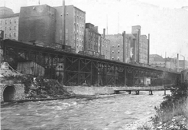
3 1. From the intersection of Main Street South East and Sixth Avenue South East, walk west toward the Stone Arch Bridge. Before you reach the bridge, on your left, will be a small garden with a stone marker. Father Hennepin Bluffs Monument On this spot in 1680, a band of Dakota led Antonine Augalle and his travelling companion, Father Hennepin, by the falls, making them the first Europeans to see the falls. Hennepin received most of the fame for what he called his discovery, when he published an exaggerated account of his travels. 2. Begin your walk across the Stone Arch Bridge. The Stone Arch Bridge Railroad tycoon and mill owner James J. Hill built the Stone Arch Bridge in Dubbed Hill s Folly because of its cost, the Stone Arch Bridge connected the west and east banks of the river, linking Minneapolis milling operations with the agricultural fields of the Dakotas and the barge and rail traffic of St. Paul. The bridge stands eighty two feet in height and has 23 arches with spans ranging from 40 to 100 feet. Built to last, the Stone Arch Bridge is composed of the same rock that forms the waterfalls edge and contains sediment layers, fossils, and fossil burrows, tell-tale reminders of the ancient tropical sea in which the rock formed. The last passenger train passed over it in 1978 and it opened to pedestrians in As you start your walk on the bridge, look to your left, where you will see the Southeast Steam Plant (now known as the Southeast Heating Plant) This steam plant, built in 1903, helped power the electric trolley cars that dominated Minneapolis streets for over forty years. The University of Minnesota purchased the plant in 1974 and set about renovating it while retaining its historic character. It now supplies steam heating to the university.


4 4. Continue walking west on the Stone Arch Bridge. On your left will be Lower Bridge/Tenth Avenue Bridge Remains A single pillar in the Mississippi is the sole remnant of an iron truss bridge that used to cross the river. The Tenth Avenue Bridge was originally built of wood in Soon an iron-truss bridge replaced it. However, the city intended the bridge for wagon use and thus did not make it strong enough to support cars or electric streetcars. Consequently, the city closed the bridge in 1934 and tore it down nine years later to provide scrap metal for use in World War II. 5. Continue walking west on the Stone Arch Bridge. On your right will be St. Anthony Falls Laboratory Located on Hennepin Island, the University of Minnesota s Saint Anthony Falls Laboratory uses water from the Mississippi, which flows underneath the building, to conduct experiments. Construction started in 1936 and ended in 1939 with the help of the Works Progress Administration, Northern States Electric, and the city of Minneapolis. The building uses the foundation of the paper mill built on Hennepin Island in Continue walking west on the Stone Arch Bridge. On your left will be The Lower St. Anthony Falls Lock and Dam Visible from the Stone Arch Bridge, the lower St. Anthony Falls Lock and Dam still produces power. Built in 1895 to 1897 by Washburn-Crosby, it earned the nickname La Barre s Folly after its incredibly high cost (nearly a million dollars) and after the engineer who thought of it, William de La Barre. The dam helped power electric street cars for fifty years


5 7. Continue walking west on the Stone Arch Bridge. On your right will be St. Anthony Falls The face of waterfall has changed over the centuries. Originally a natural waterfall dependent on the Platteville limestone, St. Anthony was in danger of collapse throughout the early years of milling. Logs would fall over it and shatter the Platteville. Also complicating manners was a dam upriver that prevented water from flowing over the falls lip. This caused the limestone to freeze during winter and crack. As early as 1866, mill owners were trying to build a large wood covering, called an apron, to cover the falls and protect it. However, floods destroyed it. Later, another miller decided to build a tunnel underneath the waterfall to increase waterpower. The plan backfired and nearly destroyed the falls. The Army Corps of Engineers stepped in and by 1880 had built a massive wall beneath the falls to prevent further erosion and a concrete apron, a forerunner to the current apron over the falls. 8. Continue walking west on the Stone Arch Bridge. On your left you will see a long man-made pier stretching downstream. At the end of that pier, stood Spirit Island Now gone, Spirit Island was a small treecovered rocky island that once stood downstream of the falls. Although the island held special significance for the Dakota, later Minneapolis residents quarried the island away to use its rock as building stone. The Army Corps of Engineers removed the last remnants of Spirit Island when they installed the lock next to the falls. 9. Continue walking west on the Stone Arch Bridge. In front of you, you will see the Washburn-Crosby A Mill and Complex The Washburn A Mill stood seven and a half stories high, making it the largest mill at the falls when it was built in However, four years later, the mill exploded and killed eighteen men. The explosion, resulting from flammable dust created by the milling process, shot the roof of the building hundreds of feet into the air and leveled a third of the falls industry. A month later, the remains of the Washburn A Mill still smoldered. However, by the next year, Washburn-Crosby rebuilt the Washburn A mill and the other millers rebuilt their mills. The mill produced flour until Its owners abandoned it, and a fire destroyed most of the mill in In 2003, the ruins became part of the Mill City Museum. 10. Continue walking west on the Stone Arch Bridge. On your right will be The Upper St. Anthony Falls Lock Between 1950 and 1963, the Army Corps of Engineers constructed a lock on the west side of the falls, vastly improving upriver navigation. The lock has a drop of 49.2 feet, the largest of any lock on the Mississippi River.


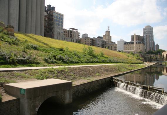
6 11. Follow the Stone Arch Bridge to the end. There, you will find a trail, immediately on your left, leading you to Mill Ruins Park. Don t take it. Walk to West River Park Road, which is the road in front of you, and follow an old wall to the corner of Portland Ave. and West River Parkway. There you will see the ruins of the Cataract Flour Mill , Artic Flour Mill/St. Anthony Mill, , Union Flour Mill, , /Holly Flour Mill, Four mills once stood in this jumble of ruins. The Cataract Mill opened in 1859 and was the first flour mill built on the west side of the river after the construction of the canal. The Artic, Union, and Holly mills became its first neighbors. Each mill was made from Platteville limestone, a rock layer found at the falls, and stood four stories tall. Their owners abandoned them by Today, the Cataract s foundation walls are visible at the corner of Portland Avenue and West River Parkway and one of its millstones rests on a wall. Cataract Millstone 12. Follow Portland Ave. east, towards the Stone Arch Bridge. It should slope downward and underneath the bridge. However, before you reach the bridge, to your left will be two Minneapolis Eastern Railroad Trestles These two stone columns once held the trestle that supported the rails of the Minneapolis Eastern Railroad and gave it access to the flour mills. The huge iron structures over the tailraces also helped support trains. Iron Trestles in Mill Ruins Park Iron Trestle in Mill Ruins Park
 Minneapolis Cotton Mill/ Excelsior Mill/ Minneapolis Flour Mfr. Co. G Mill Originally a linseed-oil mill, these ruins became a cotton mill in 1870.")
7 13. Follow Portland Ave. underneath the bridge and take a right along the pedestrian trail. You will soon be in Mill Ruins Park. Ruins (Note: you must read from right to left to correctly identify the ruins) Minneapolis Cotton Mill/ Excelsior Mill/ Minneapolis Flour Mfr. Co. G Mill Originally a linseed-oil mill, these ruins became a cotton mill in A few years later, it became the Excelsior flour mill. The mill ground flour until the 1930s. Northern States Power Company used its tailraces to produce electricity until 1960 when the mill was torn down. Minneapolis Mill/Washburn Crosby D Mill Humans at this site seem to predate Europeans. A dugout canoe was found during the excavation of the foundation for this mill in The mill was built in It exploded in 1881, starting a fire that destroyed the neighboring mills. Rebuilt by Washburn Crosby, the mill operated until 1931 when its owners tore it down. Minneapolis Paper Mill/ Pillsbury C Warehouse Alaska/Pillsbury B Mill The two-story Minneapolis Paper Mill The five-story limestone Alaska Mill was operated until the early 1890s when the built in It became the first mill owned Pillsbury Company bought the building. They by the future Pillsbury Flour Mill Company tore it down and replaced it with a five-story in After burning in 1881, the Pillsbury warehouse. While the warehouse came down Company replaced it with the six-story in 1931, Northern States Power Company had Pillsbury B Mill The building had pairs of moved into its basement, and the old turbines beautiful arched windows overlooking the of the mill produced electricity until falls. It was torn down in Clapp Woolen Mill/Empire Mill/Pillsbury B Elevator/King Midas Elevator ; Originally a woolen mill, this site became a flour mill in 1878, which burned down three years later. The site remained vacant until 1888 when the Pillsbury Company built a grain elevator for its Pillsbury B Mill. The grain elevator remained in business until 1962 and burned down seven years later. What is a tailrace? Unfortunately, the sole reminder of many of these mills is their tailrace. Tailraces are tunnels from which water exited the mill after turning the water wheel. In 1857, the Minneapolis Milling Company, which leased water to the mills, built a large underground tunnel to serve the mills. The canal, as it was called, focused water and increased its speed and water potential. From this underground tunnel came a whole network of tunnels which water flowed through turning waterwheels. The water left the tunnel through the tailrace. Palisade Mill Leonard Day Company built the Palisade Mill in They named it after the steep ravine it bordered, which still exists today. Washburn-Crosby bought the mill a decade later and doubled its size. The mill operated until 1932, when its owners removed its machinery. A fire destroyed the rest of the mill in Galaxy Flour Mill Zenith Flour Mill Pettit Flour Mill Northwestern Mill/ Northwestern Consolidated D Mill The Buried Ruins Each of these flour mills was made of limestone. The actual mills were destroyed in 1931, but their tailraces and wheel pits became part of the Consolidated Hydro Plant, producing electricity long after flour production ceased. Following their demolition, the ruins were filled with gravel and sand and await future excavation.
8


9 14. Follow the path along the Mill Ruins. You will soon be walking up an incline next to a steep ravine. At the end of this incline will be Gold Medal Park. Take a right and follow the pedestrian path running alongside West River Parkway. You should pass the Guthrie Theatre and then the Pillsbury A Mill. By then, you will be walking on a wooden boardwalk. First Avenue Canal Boardwalk Beneath the boardwalk lies a large canal the Minneapolis Company excavated in The canal started above the falls and ran for more than two hundred feet, helping to focus water flow to increase water power potential. To build the canal, workers removed the St. Peter s Sandstone and had water running beneath the Platteville formation. The canal greatly increased production of lumber and later flour on the west side of the falls. 15. Continue walking on the path. On your left, you should see North Star Woolen Mill A number of entrepreneurs started failed business ventures with cloth at the falls. The only one with any success was the North Star Woolen Mill, which began operations in 1864 and produced scarves, flannels, blankets, and yarns until the 1940s. 16. Continue walking on the path. At the intersection of Portland Ave. and West River Parkway, you will see a set of ruins on your right. Clapp Woolen Mill/Empire Mill/Pillsbury B Elevator/King Midas Elevator ; Ruins These are part of the foundation of the Pillsbury B Elevator. Originally a woolen mill, this site became a flour mill in 1878, burning down three years later. The site remained vacant until 1888 when the Pillsbury Company built a grain elevator for its Pillsbury B Mill. The grain elevator remained in business until 1962 and burned down seven years later. 17. Walk north on Portland Ave. You will see a staircase, and at the top of that staircase will be the Fuji-Ya To see the ruins of the Fuji-Ya, walk around to the east side of the building, the side that faces the river and falls. Before moving to its Lake Street and Lyndale location, this Japanese restaurant was the first of many revitalization efforts at the falls. Built by Reiko Weston in 1968, its parking lot incorporated many parts of the Columbia flour mill, while the restaurant s foundation incorporates parts of the Basset Sawmill which burned down in Basset Sawmill (in foundation of Fuji-Ya) Columbia Flour Mill (parking lot of Fuji-Ya)


10 18. After taking a look around the Fuji-Ya, return to the staircase. At the top of the staircase you will be at the intersection of First Street and Fifth Avenue. At the corner of Fifth and First, you will see the Crown Roller Mill and Boiler House The Crown Roller Mill was the second largest flour mill on the west side. It operated from 1880 until the early 1950s. A fire ripped through it in 1983, destroying the interior. Rather than destroying the rest of the mill, the city of Minneapolis helped rebuild it. It currently leases office buildings. The southern part of the building, with the smoke stack, was a boiler room, which helped power the mill. 19. Walk west on Fifth Avenue, away from the river. Behind the Crown Roller Mill is the Standard Mill Dorilus Morrison, the first mayor of Minneapolis, built this mill in In the 1940s, flour milling ceased and the building was converted into a warehouse. In 1987, the mill became a luxury hotel. It now leases condominiums. 20. Walk west on Fifth Avenue. At the intersection of Fifth Avenue and South 2 nd Street, you will see the Ceresota Elevator Built in 1908, the Northwestern Consolidated Milling Company s Elevator A, also known as the Ceresota Elevator, had a capacity of one million bushels, the largest of any elevator in the milling district. It remained a grain elevator until 1987, when it was converted into office space. 21. Continue on Fifth Ave Southeast. Take a right onto Washington Ave. and continue north until you meet the intersection of Washington and 3 rd Ave. at the corner of Washington and 3 rd will be The Milwaukee Road Railroad Depot Built in 1899, this depot served the Chicago, Milwaukee and St. Paul Railroad. During its peak years, twenty nine trains a day left the station. The last train left the station in 1971 and the building soon became office space. It now features two hotels, an indoor water park, an interpretive museum, a restaurant, a bar, and an underground parking garage. 22. At the intersection of Washington and 3 rd Ave. South East, take a right and walk for a block until the intersection of 3 rd Ave. SE and 2 nd Street S. On your right will be The Milwaukee Road Freight Depot Built in 1875, this building connected to a railroad depot that predated the one that still stands today. It stored freight and served as a package drop-off point until it became vacant in the early 1970s. In 1998, it became a Dunn Bros. Coffee House.
 In 1877, Albert R. Hall and Marcus C.")


 built a wooden suspension bridge connecting their cities.")
11 23. Continue on 3 rd Ave. Southeast and cross South 2 nd St. At the corner of 3 rd Ave. and 2 nd St. you should be able to see Mill Place (Hall and Dann Barrel Factory, 1880) In 1877, Albert R. Hall and Marcus C. Dann formed a partnership to make barrels to ship flour. They moved to this location in 1880 and were reputed to be one of the largest cooperages in the world. By 1890, they had stopped producing barrels and produced cloth bags instead. Like many other mill buildings, it now houses offices. 24. Walk east on 3 rd Ave., past Mill Place, and cross First St. Take a left on First St. and continue until you meet Hennepin Ave. Take a right on Hennepin Ave. and walk towards the extension bridge. On the extension bridge, take the staircase on your left to First Bridge Park, beneath the suspension bridge. 2 nd Bridge Foundation Bridge Anchor with Supporting Cables Remains of the Second Hennepin Ave. Suspension Bridge In 1857, the cities of Minneapolis and St. Anthony (which joined Minneapolis in 1872) built a wooden suspension bridge connecting their cities. It became the first bridge spanning the Mississippi. Over the years, the city has replaced the bridge three times. Beneath the current suspension bridge are the remains of the second bridge; its foundation of limestone blocks, two anchors, and supporting cables. The supporting cables held up the bridge while the anchors kept the cables attached to the ground. 2 nd Bridge Current Bridge


12 25. Take the staircase back up to the Hennepin Ave. Bridge and continue east on Hennepin Ave. Across the bridge you should see the Grain Belt Beer Neon Billboard Grain Belt Beer was a product of the Minneapolis Brewing Company, an enterprise formed by the merger of four local breweries in The company built the sign in 1940 as part of a gambit to increase sales during the Great Depression and the years following prohibition. The Grain Belt Brewery, upstream of Nicollet Island, closed in the 1970s. The city now owns the sign. 26. Continue across the bridge and take the first left you find. It will take you to Hennepin Island. Follow the street and take a left onto Merriam Street. In front of you, you will see Bell of Two Friends Ibarki, Japan, Minneapolis s sister city, presented this twelve foot sculpture based on the design and shape of a 2,000 year old bell found in Ibarki in 2001 to honor their twenty year friendship. 27. Turn around and walk east on Merriam St. On your left you should see Nicollet Island Stock Pavilion This pavilion dates to 1892 and housed the William Bros Boiler Works. A fire destroyed it a year later, but it was rebuilt and added onto to form the Durkee-Atwood Complex. In 1983, the Parks Board purchased the complex and demolished most the buildings except for the pavilion. Director Brian Levant filmed part of Jingle All the Way, starring Arnold Schwarzenegger, here. 28. Continue to walk east on Merriam St. On your right, before you cross the Merriam St. Bridge, you will see Nicollet Island Inn Built in 1893, this building was a sash, door, and blind manufacturing factory. In 1913, the Salvation Army bought the building and ran a men s shelter in it for sixty years. They finally sold it to the Minneapolis Parks Board. The building fell into disrepair until developers bought it, fixed it up, and reopened it as a restaurant and inn.


13 29. Cross the Merriam Street Bridge This Bridge was originally one of four trusses of a railroad bridge that crossed the Mississippi a mile upriver from Nicollet. In 1986, the bridge was demolished and this truss was floated downriver to its current location where it became a pedestrian bridge 30. Immediately in front of you, at 25 Main Street SE will be Brown-Ryan Livery Stable Built in 1880, this stable was originally located at Second St. NE. However, the building was in the way of a high-rise project and the city moved it to this location in The entrance of the originally building does not face the street but faces the plaza shared by the entrance to Riverside Apartments. 31. Take a left onto Main Street SE. In the plaza to the immediate right of the Brown- Ryan Livery Stable, you will see Our Lady of Lourdes First Universalist Society finished construction on this church, built from the Platteville limestone of the falls, in Twenty years later, the Catholic French Canadian community purchased the building. The church is the longest operating church in the Minneapolis area. 32. Walk south on Main Street. Stop at 29 Main St. Kronick Warehouse After a fire destroyed the previous factory at this location, the Levin Brothers built a five story factory and warehouse in By the 1940s, the building was only a warehouse. However, by the 1960s, it had become home to a number of artists until the city bought and sold it to the Riverplace apartment complex, which added the glass and metal arched front. 33. Continue south on Main Street. Stop at 117 Main Street Pracna Frank Pracna built this three-story building in He and his family lived in the upper floors of the building. Downstairs he ran a popular saloon for workmen at the falls until the onset of prohibition. In the following years, the building served as a warehouse and a machine shop until architect Peter Hall bought it and opened it as a restaurant in 1969.


14 34. Walk South on Main Street. Stop at 127 Main Street Morrison/Martin Blocks In 1858, Captain John Martin built a beautiful limestone building with four windows going across. Francis Morrison, who owned the property to the left of it, decided to build a store imitating its design, but only had the space for three windows. The upper floors served as offices for doctors, lawyers, and dentists. The buildings were also home to two newspapers until the Union Iron Works, which occupied the space next door, purchased it and converted it to factory use. In 1985, St. Anthony Main renovated the building and included it in its complex. 35. Continue south. Stop at 129 Main St. Upton Block/Union Iron Works This building is made of Minneapolis brick and first served as a hardware store for the Upton Brothers before they moved their store across the river. It housed various retail stores and a newspaper until the Union Iron Works bought it in The Iron Works produced machinery for the mills and remained in the Upton Block until The building Morrison Block Martin Block Upton became a warehouse until St. Anthony Main renovated it in Take a right into Xcel Energy Waterpower Park. On your left will be Main Street Station The Minnesota General Electric Company built this power station in Water produced a little less than half the electricity from the station. The building burned down in 1911 and was rebuilt. The plant stopped producing power in Walk east and follow the pedestrian trail in the power park. When you have passed Main Street Station, turn around and look at the east bank of the river. In front of the Morrison, Martin, and Upton Blocks you will see the Pillsbury A Headrace To power the Pillsbury A Mill, its owners built a tunnel underneath the building and underneath part of Main Street. Water rushing through this tunnel, called a canal, would turn water wheels, providing power to the mill. The canal focused water, increasing its speed and thus increasing the amount of power it generated. Water would enter through the headrace.


 in 1892 as part of their box spring and mattresses")
15 38. Continue to follow the pedestrian path to the overlook above the falls. As you look, notice the huge v- shaped upriver of the falls. It goes underneath the Third Avenue Bridge Upper St. Anthony Falls Dam In 1856, the west and east side milling interests consolidated their waterpower, forming two companies, the Minneapolis Milling Company and the St. Anthony Waterpower Company. These companies controlled the waterpower and land along the falls and leased the water to mills. However, before they could start leasing, the companies had to evenly divide the water of the falls between themselves. To achieve this, they constructed a v-shaped dam above the falls. By diverting the water into two different millponds, the dam allowed the two power companies of the falls to develop independently. The basic shape of the dam still exists today. Above: Main Street Left: 221 Main Street 39. After you are finished with looking at the falls, exit the park and take a right onto Main Street Southeast. Walk south and stop at 201 Main Street. On your left will be the Salisbury & Satterlee Company Complex Salisbury and Satterlee built the five story red brick building (at 221 Main Street) in 1892 as part of their box spring and mattresses manufacturing business. They added onto it with a small two story addition in 1909 ( Main Street). The Jefferson Company, which owns St. Anthony Main, bought the buildings in 1977 and renovated them. 40. Continue south on Main Street. At the intersection of 3 rd Avenue and Main Street, on the left, you will see the Pillsbury A Mill The Pillsbury A Mill was the largest flour milling operation at the falls and for a short time, the largest flour mill in the world. Built in 1881, the mill stood seven stories tall, cost half a million dollars, and produced four thousand barrels (one barrel = 60 pounds of flour) of flour a day. The last mill operating at the falls, it closed in If you continue south on Main Street, you will come to Father Hennepin Park, where you started the tour.
illing Era power for our society, in this age of alternate forms of energy, falling water may seem like a quaint old-fashioned way to power a mill.
 Saint Anthony Falls Historic Walking Tour The tour starts at the Father Hennepin Park sign shown below, a half block south of the intersection of SE Main Street and SE 3 rd Avenue on the east side of the
Walking/Cycling Tour of Saint Anthony Falls
 UNIVERSITY OF MINNESOTA DEPARTMENT OF EARTH SCIENCES Walking/Cycling Tour of Saint Anthony Falls Name: Lab Instructor: Copyright 2013 - all rights reserved KCK Walking/Cycling Tour of Saint Anthony Falls
Mankato s Transportation Heritage
 Mankato s Transportation Heritage City of Mankato Mankato Heritage Preservation Commission May 11, 2017 1. Union Depot, 112 S. Riverfront Drive, c. 1896. The railroads were Mankato s dominant transportation
The Falls: A Visitor & Interpretive Center for the Upper Lock
 The Falls: A Visitor & Interpretive Center for the Upper Lock Image courtesy of Northern Spark Surface by Aaron Dysart Illuminate the Lock is a program of Mississippi Park Connection The Falls Initiative
WORK NEIGHBORHOOD GUIDE EAST TOWN. Discover Minneapolis's New Indoor / Outdoor Neighborhood SHOP
 WORK NEIGHBORHOOD GUIDE EAST TOWN Discover 's New Indoor / Outdoor Neighborhood SHOP PLAY STAY LIVE EAT WHERE IS EAST TOWN? NORTH LOOP WAREHOUSE DISTRICT MISSISSIPPI RIVER NORTHEAST CBD EAST TOWN LORING
INLAND STEEL COMPANY, INDIANA HARBOR WORKS PHOTOGRAPHS,
 Collection # P 0711 INLAND STEEL COMPANY, INDIANA HARBOR WORKS PHOTOGRAPHS, 1926 Collection Information 1 Historical Sketch 2 Scope and Content Note 3 Contents 4 Processed by Dalton Gackle July 2018 Manuscript
BROWN S RACE - HIGH FALLS
 BROWN S RACE - HIGH FALLS Distance:.6 miles Begin: Kodak Tower (343 State Street) End: Commercial and Mill Streets Welcome to Kodak s neighborhood! Rochester s tradition of repurposing older buildings
ARCHIVES MONTH in Washington!
 ARCHIVES MONTH in Washington! We received an invitation in September from The State Archives to participate in Archives Month : 2014 is the 125th anniversary of Washington reaching statehood. It is a momentous
BACKROADS BICYCLE/AUTOMOBILE TOUR OF MIDDLESEX, VERMONT
 BACKROADS BICYCLE/AUTOMOBILE TOUR OF MIDDLESEX, VERMONT (created and published by the Middlesex Historical Society) Welcome to a 25-mile self-guided historical tour of the backroads of Middlesex. You may
No. 23. Milling Around. Motor Mill Historic Site Newsletter. Larry Stone. Clayton County Conservation Board Osborne Rd.
 Motor Mill Foundation Summer 2016 No. 23 Milling Around Motor Mill Historic Site Newsletter Larry Stone Clayton County Conservation Board 29862 Osborne Rd Elkader, IA 52043 The completion of the new bridge
TOPIC: Flour AYRES NEWSPAPER INDEX
 Paper Day Month Year Column M AD Annotation Arizona (Weekly) Citizen 15 10 1870 3 1 Gen. Allen, flour mill in Altar, Sonora Arizona (Weekly) Citizen 29 10 1870 3 2 Tucson flour mill, Lee and Scott's new
IRONCLAD. MINNEAPOLIS 811 Washington Ave 1. live.work.explore. MINNEAPOLIS 811 Washington Ave
 IRONCLAD live.work.explore. 1 WELCOME TO IRONCLAD neighborhood overview One of the hottest development areas of Downtown, Ironclad offers a high-end, mixed-use development consisting of highrise apartments,
Redesigning The Waterfront
 San Francisco Maritime National Park Service U.S. Department of the Interior National Historical Park California Redesigning The Waterfront A Self-Guided Walking Tour Then & Black Point Cove, ca. 1910.
Sandwiching in History Union Station 1400 W. Markham, LR December 2, 2011 By: Rachel Silva
 1 Sandwiching in History Union Station 1400 W. Markham, LR December 2, 2011 By: Rachel Silva Intro Hi, my name is Rachel Silva, and I work for the Arkansas Historic Preservation Program. Welcome to the
Below is the section of the Byway discussed in the Dickenson County meeting. Primary coal sites are noted on the map.
 APPENDIX H: PUBLIC PARTICIPATION SERIES OF MEETINGS Virginia Coal Heritage Trail Corridor Management Plan Meeting in Haysi on the Dickenson County portions of the Pocahontas Trail September 23 rd 2010
A History of the Detroit Riverfront. From 1760 though to the
 A History of the Detroit Riverfront From 1760 though to the Detroit attracts immigrant workers 176o-1800 AD 1805 AD A devastating fire sweeps through Detroit, destroying all 200 of its structures except
Cataract s Historical Falls BY ANDREW HIND n PHOTOS BY MIKE DAVIS
 20 Niagara Escarpment Views summer 2015 Cataract s Historical Falls BY ANDREW HIND n PHOTOS BY MIKE DAVIS Ontario s most dramatic waterfall is, quite obviously, located at Niagara. It s a world wonder
STATEMENT OF SIGNIFICANCE
 1765 Columbia Avenue - Miners Union Hall Miners Hall 2012 Heritage Register - Building 1) Historical Name: Miners Union Hall 2) Common Name: Miners Hall 3) Address: 1765 Columbia Avenue 4) Date of Construction:
Photographic Log Client: Project Number: Site Location: Site Name: Photograph ID: Date: Location: Direction: Comments: Photograph ID:
 Photograph ID: 1 west View of one of the monitoring well and the large parking lot on the south side of Center Street. Photograph ID: 2 Monitoring well located in the middle of the parking lot located
Feature Article. The Bridges of Fall City
 Feature Article The Bridges of Fall City Some classic Fall City bridge photos were added to our collection in 2015. The eras of Fall City are closely connected to how one got across the Snoqualmie River.
River First Initiative and Waterworks Park
 River First Initiative and Waterworks Park The RiverFIRST proposal is critical to the creation of a larger regional parks and trails network, as well as ecological and infrastructure system. When realized,
Segment 2: La Crescent to Miller s Corner
 goal of the USFWS refuges is to conserve, protect and enhance fish, wildlife and plants and their habitats for the continuing benefit of the American people. Refuge lands are used largely for fishing,
Unit 11: Travel and Trade
 Unit 11: Travel and Trade Today Due: Current Events Article Assignment Quiz: Unit 10 (Value of Land) In class: Unit 11 (Travel and Trade) HW: wkbk 97-102, study for quiz 11, read Unit 12 (155-166) Lesson
Lodsbridge Mill, Selham, West Sussex
 Lodsbridge Mill, Selham, West Sussex A small estate with an 18th Century former watermill on the banks of the River Rother, separate 17th Century cottage, spa complex and stabling, total 18.73 acres (7.58
railroad tracks. In 1932
 238 W. Tampa Avenue: Originally San Marco Hotel This three-story, steel-reinforced, concrete block, stuccoed building was commissioned by the Brotherhood of Locomotive Engineers (BLE) as a 92 room hotel
Turn right at Village St.
 A walk around MEDWAY VILLAGE National Historic District new hall was built in the Second Renaissance style and originally combined commercial uses on the first floor including a grocery and tobacconist,
Economy 3. This region s economy was based on agriculture. 4. This region produced items such as textiles, iron, and ships in great quantities. For th
 Geography 1. This region has a climate of warm summers and snowy cold winters. 2. This region has a climate that is generally warm and sunny, with long, hot, humid summers, and mild winters, and heavy
President Roosevelt and Naturalist John Burroughs at Fort Yellowstone. Ruined Castles of Yellowstone. East Entrance Station
 President Roosevelt and Naturalist John Burroughs at Fort Yellowstone Ruined Castles of Yellowstone East Entrance Station President Roosevelt at Liberty Cap Yellowstone Lake, Mary s Bay Fire Hole River
DEVELOPMENT OPPORTUNITY 630 Central Park Yonkers, NY 10704
 DEVELOPMENT OPPORTUNITY 630 Central Park Yonkers, NY 10704 1 Offering Memorandum 630 Central Park, Yonkers, NY 10704 +/-200,000 Square Feet Industrial Building Redevelopment Opportunity 630 Central Park
RICH RAILROAD HISTORY Along the Virginia Coal Heritage Trail
 APPENDIX M Rich Railroad History In the process of developing a corridor management plan for the Virginia Coal Heritage Trail, it became clear the railroad played a huge role in the development of Southwest
View of History Tour A walking Tour around Hodges Park developed for Buchheit Day, May 24, 2018
 View of History Tour A walking Tour around Hodges Park developed for Buchheit Day, May 24, 2018 We acknowledge Milt Nelson of the Park Ridge Heritage Committee for the inspiration and development of this
The Railway History of St. Thomas
 The Railway History of St. Thomas 23 October 1849: Sod-turning commences in London for the Great Western Railway, the first railroad that will reach from Windsor to Niagara Falls. This is the shortest
Central Mississippi Riverfront Regional Park Master Plan
 9/19/2012 Mill District Neighborhood Association 2 Metropolitan Council Regional Parks & Trails Map (Regional Parks status) + (Met Council approved master plan) = access to funding 9/19/2012 Mill District
The Tacoma Star of Destiny
 The Tacoma Star of Destiny The Tacoma Star of Destiny is an advertising tool that was developed early in the 20th century touting all the advantages of Tacoma, WA. The following is the list of the manufacturers,
Phenix, MO. The History of a Ghost Town
 If the statement is true that a town is only a town when it is on the map, then the only town remaining in Phenix, MO, is in the memories of those few who still call it home. A quick review of two state
Greene Park Historic Walking Tour
 Greene Park Historic Walking Tour Created by Weston J. Myers 2015 Joint Base Lewis-McChord History of Greene Park In 1917, Major General Henry A. Greene had an idea to create an amusement park to provide
STATE OF IOWA. Historical and Architectural Survey for 2008 Flood Projects in Vinton, Benton County
 STATE OF IOWA CHESTER J. CULVER GOVERNOR PATTY JUDGE LT. GOVERNOR DEPARTMENT OF PUBLIC DEFENSE IOWA HOMELAND SECURITY AND EMERGENCY MANAGEMENT DIVISION DAVID L. MILLER, ADMINISTRATOR Historical and Architectural
Historic NIAGARA S SOUTH COAST. Welland Canal. History of the Welland Canal in Port Colborne. Uncharted Unexpected.
 Historic NIAGARA S SOUTH COAST Welland Canal History of the Welland Canal in Port Colborne Uncharted Unexpected www.portcolborne.ca The Welland Canal was originally established as solution to summer water
48 ALBERT STREET ROYAL ALBERT HOTEL
 48 ALBERT STREET ROYAL ALBERT HOTEL HISTORICAL BUILDINGS COMMITTEE 12 December, 1980 48 ALBERT STREET Royal Albert Hotel This hotel has an elusive history shaped by factors of time and place. It was never
Cassadaga HISTORIC WALKING TOUR OF
 HISTORIC WALKING TOUR OF Cassadaga This tour was developed by Citizens for a Better Cassadaga, with the generous financial support of the Chautauqua County Health Network, as part of Creating Healthy Schools
ROUKEN GLEN: BANDSTAND 2015 DATA STRUCTURE REPORT
 ROUKEN GLEN: BANDSTAND 2015 DATA STRUCTURE REPORT Author (s) Ian Hill Editors Report Date June 2015 Working Partners Funders Phil Richardson East Renfrewshire Council East Renfrewshire Council, Heritage
Bridge Collapse. Minneapolis Public Works Department. Presented by Steven Kotke, P.E. - Director of Public Works
 Bridge Collapse Minneapolis Public Works Department Presented by Steven Kotke, P.E. - Director of Public Works 1 St. Anthony Falls I-35W Bridge History Construction started in 1964 Opened to traffic in
POSTCARDS AND OLD PHOTOS OF THE PARK ERA, The Midway
 POSTCARDS AND OLD PHOTOS OF THE PARK ERA, 1885-1911 The majority of these photographs appear to have been taken during the latter period of the park, circa 1905 to 1911. The Midway A lovely afternoon at
Revitalization of the previous Marine Police Headquarters in Tsim Sha Tsui
 Revitalization of the previous Marine Police Headquarters in Tsim Sha Tsui The former Marine Police Headquarters was constructed in 1884, comprises a main building, a stable block and signal tower. The
Presentation Overview
 DON NARROWS Historical and Existing Conditions March 29, 2008 Presentation Overview 1. Project Location and Background 2. Historical Context How did the Don Narrows Come to Be? 3. The Today 4. Next Steps
SOL VS.2a, 2b, 2c, 10b
 What are the characteristics of the Coastal Plain? 1. Also known as Tidewater 2. Located near the Atlantic Ocean and the Chesapeake Bay 3. Includes the Eastern Shore, a peninsula between the Atlantic Ocean
Guadalupe Delta Log Jam History & GBRA Operations in the Lower Basin. March 23, 2017
 Guadalupe Delta Log Jam History & GBRA Operations in the Lower Basin March 23, 2017 Guadalupe Watershed Geographic Regions Guadalupe Watershed Geographic Regions Flat Delta Geomorphology Upper Delta Middle
Difficult Run Stream Valley Park
 Difficult Run Stream Valley Park The more intense mountain bikers have known about for Difficult Run for some time. Equestrians have known it longer. Eight miles of unpaved trail, the Rails to River Trail
THE BLOCK HOUSE. A time where yesterday is not necessarily the day before today: but a past that no longer exists.
 THE BLOCK HOUSE Going around in Tell el Eisa, obvious to those who know where to go, you can cross small areas where there are still many relics from the period of the battles of El Alamein. Some of these
Southwest LRT Alignment Video Narration
 Southwest LRT Alignment Video Narration September 2015 Southwest Light Rail Transit, a proposed extension of the METRO Green Line, will serve Minneapolis, St. Louis Park, Hopkins, Minnetonka and Eden Prairie.
DETROIT, TOLEDO, AND IRONTON RAILROAD PHOTOGRAPHS SUBSERIES, Accession 548
 Finding Aid for DETROIT, TOLEDO, AND IRONTON RAILROAD PHOTOGRAPHS SUBSERIES, 1922-1923 Finding Aid Published: June 2011 20900 Oakwood Boulevard Dearborn, MI 48124-5029 USA research.center@thehenryford.org
Keeseville. A walk through historic. Words and pictures by Lee Manchester, Lake Placid News, October 8, 2004
 A walk through historic Keeseville Words and pictures by Lee Manchester, Lake Placid News, October 8, 2004 A group of about 30 tourists took a stroll last Thursday afternoon through the history of Keeseville,
Coney Island: Visions of an American Dreamland
 Coney Island: Visions of an American Dreamland Coney Island Timeline Here are some key events related to the development of Coney Island and in relation to world s fairs and expositions around the United
RAILROADS IN ACTON THE DEVELOPMENT OF A NEW ENGLAND TOWN. The Acton Historical Society The Friends of Bedford Depot Park.
 RAILROADS IN ACTON THE DEVELOPMENT OF A NEW ENGLAND TOWN The Acton Historical Society The Friends of Bedford Depot Park October 27, 2018 Acknowledgements Bill Klauer, Acton Town Historian Lisa Soo, Acton
Hey, Buddy, Wanna Buy a Piece of the Empire State Building?
 08 December 2011 voaspecialenglish.com Hey, Buddy, Wanna Buy a Piece of the Empire State Building? The Empire State Building in New York Correction attached (You can download an MP3 of this story at voaspecialenglish.com)
I INTRODUCTION AND BACKGROUND
 I INTRODUCTION AND BACKGROUND INTRODUCTION AND BACKGROUND - I I INTRODUCTION AND BACKGROUND a. project setting Looking south to the project site The Davenport Cement Plant (also referred to as the Cemex
The Holes Creek Bridge Replacement By Bradley McClelland
 The Holes Creek Bridge Replacement By Bradley McClelland Each time there is a heavy rainstorm, the folks along Sheffield Road in the Dayton, Ohio suburb of West Carrollton have cause to be concerned. Holes
LOCATION, CLIMATE, AND NATURAL RESOURCES OF MEXICO
 SS6G3 The student will explain the impact of location, climate, distribution of natural resources, and population distribution on Latin America and the Caribbean. a. Compare how the location, climate,
New York City Photo s
 New York City Photo s 05-07-12 Sunlight floods in through windows in the vaulted main room of New York City's Grand Central Terminal, illuminating the main concourse, ticket windows and information kiosk.
301 7½ Street SW
 301 7½ Street SW 104-0213-0072 Primary Resource Information: Single Dwelling, Stories 2.00, Style: Other, ca 1890 July 2006: This late-19th-century, 3-bay, 2-story, hip-roofed frame I-house features projecting
THE USA. The capital of USA is Washington D.C., in the District of Columbia.
 THE USA The United States of America is the richest and one of the biggest countries in the world. It has a population of about 295 million people. It is divided into 50 states; two of them, Alaska and
and plant some trees, but that was only accomplished through state and federal work-relief programs.
 PEAVEY LOCATION AND HISTORY Peavey Park sits in the Phillips Community on a large block bounded by major streets: Franklin Avenue, Chicago Avenue, and Park Avenue. The southern continue through to Chicago
COMMUNITY PROFILE Uptown, Minneapolis
 COMMUNITY PROFILE Uptown, Minneapolis 394 HENNEPIN AVE LYNDALE AVE 94 Uptown DOWNTOWN MINNEAPOLIS 35W W. LAKE STREET 35W 94 Uptown is a vibrant commercial and residential district located two miles southwest
Havelock Station. Atlantic & East Carolina
 Havelock Station Atlantic & East Carolina Edward Ellis Havelock City Historian January 22, 2008 Atlantic & East Carolina Railway Freight Depot, Havelock, N.C., circa 1998, view facing south. A Little History
Monuments of Washington, D.C.
 urmoments/123rf Stock Photo Monuments of Washington, D.C. Shutterstock.com/Gary Blakeley Touring the Cherry Trees There are about 3,000 cherry trees around the Tidal Basin and on the grounds of the Washington
(west) onto Charleston Boulevard. Drive 16 miles on Charleston and turn right into Red Rock
 onto Charleston Boulevard. Drive 16 miles on Charleston and turn right into Red Rock") Hike: North Peak and Ice Box Overlook up and back Trailhead: 2.5 miles up the Rocky Gap Road not mark Distance: 5 miles round trip Elevation gain: 2,694 feet Elevation Peak: 7,094 feet Time: 3 to 5 hours
Hike: North Peak and Ice Box Overlook up and back Trailhead: 2.5 miles up the Rocky Gap Road not mark Distance: 5 miles round trip Elevation gain: 2,694 feet Elevation Peak: 7,094 feet Time: 3 to 5 hours
A Brief History of Williams. by Marlys Hirst
 A Brief History of Williams by Marlys Hirst Williams, Minnesota got its start when the Canadian railway line from Winnipeg to Thunder Bay was built through the area between 1899 and 1900. Two men who worked
A Visit to Cloud Cap Inn
 October 2018 A Visit to Cloud Cap Inn Webfooters Post Card Club PO Box 17240 Portland OR 97217-0240 www.thewebfooters.com A Visit to Cloud Cap Inn Above the Clouds Mountain climbers visit Cloud Cap Inn,
2.1 HISTORIC CONTEXT. View looking South from Main & 6th circa Typical logging scene with bullocks and skid road, 1885
 2.1 HISTORIC CONTEXT View looking North from Main & 7th circa 1889 View looking South from Main & 6th circa 1893 Typical logging scene with bullocks and skid road, 1885 The history of the Mt. Pleasant
Bridgetown. O Briensbridge. Knockadrohid. Ardataggle. Fairyhall. Cappakea. Montpelier. Derryhasna. Aughboy. Drummeen Kildoorus.
 Bridgetown Knockadrohid O Briensbridge had been on the main water- road from Limerick to Dublin from 1799 until the last trading boat passed through in June 1929 From the late eighteenth century it was
Historic Bridge Foundation Facebook Archives
 Historic Bridge Foundation Facebook Archives Did You Know There is only one known surviving Page bascule in the United States, following the recent illegal scrapping of the Page bascule in Hammond, Indiana?
RAY YENKANA Willowbrook Cr, Dawson Creek BC Canada $2,847,000
 1716 Willowbrook Cr, Dawson Creek BC Canada For SALE $2,847,000 This is a rare find, 32 townhomes in Dawson Creek, BC. Excellent investment in a single title multi family complex. Vendor has upgraded this
Stone Mills. Rob Arkell: Trowbridge Archaeology Group
 Stone Mills Rob Arkell: Trowbridge Archaeology Group Stone Mills Main Building 2013 A mill linked to Trowbridge Castle stood on the site of Stone Mills as far back as 1331 and the site was acquired by
SWINGING OVER SCHUYLKILL THE HISTORY OF THE PW&B AND BRIDGE NO. 31
 THE SWINGING OVER SCHUYLKILL THE HISTORY OF THE PW&B AND BRIDGE NO. 31 The Philadelphia, Wilmington & Baltimore Railroad Company (PW&B) was formed in 1836. In 1838, the railroad was enlarged by the joining
Driving Time: 3 hours (allow extra time for stops)
") Scenic Byways loop This journey takes visitors through the eastern edge of Mt. Rainier National Park and along two of Washington s most beloved scenic byways, the Chinook Byway and the White Pass Scenic
Scenic Byways loop This journey takes visitors through the eastern edge of Mt. Rainier National Park and along two of Washington s most beloved scenic byways, the Chinook Byway and the White Pass Scenic
For Sale. Furman Hall Road Greenville, South Carolina / ACRES IN CHERRYDALE AREA. For More Information, Contact: FURMAN HALL RD
 POINSETT HWY FURMAN HALL RD +/- 2.84 ACRES IN CHERRYDALE AREA For Sale Furman Hall Road Greenville, South Carolina 29609 Tabitha Cooper Associate Industrial & Investment Services O 864.334.4145 F 843.725.7201
in the nineteen eighties, France built a freeway linking Paris directly with Spain 5:26
 0:01 This is the Millau viaduct 0:04 The tallest bridge in the world 0:06 It s highest tower stretches a staggering three hundred and 0:09 forty-three meters 0:11 so high 0:12 The bridge glides above the
Vladivostok, Russia Day 12 Oct. 9:
 Vladivostok, Russia Day 12 Oct. 9: The Amsterdam was docked in Vladivostok by 6am. It was still dark outside but the nearby train station that serves as the Eastern Terminal of the Trans-Siberian Railroad
Hwy Retaining Wall/ Sea Wall. Not Eligible, see Statement of Significance Also member of listed NR district: Mantorville Historic District
 Historic Name CS # 2007 Other Name SHPO Inv # Location E and W sides of TH 57 between 6th St and 7th St Hwy District Reference City/Township County Mantorville, City of Dodge Acres Twp Rng Sec 107N 16W
Our Lady and St Edward. Gordon Road, St Ann s, Nottingham NG3. National Grid Reference SK Statement of Importance
 Our Lady and St Edward Gordon Road, St Ann s, Nottingham NG3 National Grid Reference SK 586 409 Statement of Importance The rather unprepossessing exterior of the church contrasts with the reposeful and
Below is the section of the Byway discussed in the Wise County meeting. Primary coal sites are noted on the map.
 APPENDIX H: PUBLIC PARTICIPATION SERIES OF MEETINGS Virginia Coal Heritage Trail Corridor Management Plan Meeting In Big Stone Gap on the Wise County portion of the Norton Loop September 20 th 2010 at
Baslow & Bubnell Page 1 of 5 A Comparison
 Baslow & Bubnell Page 1 of 5 Introduction This paper describes the number of houses in Baslow and Bubnell from 1670 up to the present day. Most of the data was obtained by counting the buildings on a series
Captions/Proof Sheets for 97 Alberta Coal Branch & related images to accompany Kodak PhotoCD and slides; A C Lynn Zelmer, photographer
 A selection of 100 35mm colour slides was sent to Kodak Australia for scanning to PhotoCD format as an experiment in c1997. Since the digital images were intended for use at a conference, appropriate images
FOR SALE : Land. XXXX St. Croix Trail S, Denmark Township, MN ACRES/4 PARCELS - RESIDENTIAL DEVELOPMENT FACTS & FEATURES
 FACTS & FEATURES List Price: $560,000 Property Type: Residential Land for Development Total Site - 10 Acres Currently Could Build 2 Homes on 5 Acres each Being Re-Platted for 4 lots ~2.5 Acres each Zoning:
The Packard plant was known for its big, strong buildings. These structures were famous for their open spaces and use of sunlight. The Packard Plant i
 Hello and welcome back to a special program of As It Is a way for you to learn and improve your American English. I m Jim Tedder in Washington. Today we take you to Detroit, Michigan, and visit what was
Much of the information which follows is included by kind permission of the Tynedale Council (now defunct) and is based on its brochure.
 and is based on its brochure.") The Tyne Green Trail This easy going circular walk is on level ground throughout. It follows the course of the River Tyne between Hexham Bridge and the turning point just past Watersmeet. The return is
The Tyne Green Trail This easy going circular walk is on level ground throughout. It follows the course of the River Tyne between Hexham Bridge and the turning point just past Watersmeet. The return is
 The Atlanta BeltLine is actively transforming Atlanta s neighborhoods, consumption habits, and travel and transit routes. Stream Realty Partners seized the opportunity to invest in the Westside Trail and
Tower Bridge Learning Self-guided visit resources
 Tower Bridge Learning Self-guided visit resources Thank you for booking a visit to Tower Bridge Exhibition, we hope you enjoy your visit. This pack contains information and activity ideas for you to do
THE FORMER GIRLS' HIGH SCHOOL IN MOSTAR A D A P T I V E R E - U S E P R O P O S A L F O R
 THE FORMER GIRLS' HIGH SCHOOL IN MOSTAR A D A P T I V E R E - U S E P R O P O S A L F O R A M A J O R P U B L I C B U I L D I N G I N T H E O L D C I T Y 1. INTRODUCTION Dr. Stefano Bianca, Director, Historic
Trading on the Wilts and Berks Canal
 Vale and Downland Museum Local History Series Trading on the Wilts and Berks Canal Reg Wilkinson Since the formation of the Wilts & Berks Canal Amenity Group in October 1977, attention has focused on the
CHURCH CLIFF HOUSE FILEY NORTH YORKSHIRE YO14 9ET
 CHURCH CLIFF HOUSE FILEY NORTH YORKSHIRE YO14 9ET Scarborough 8 miles / Malton 23 miles, York 41 miles (London Kings Cross 1 hr 55 mins) Beverley 34 miles, M62 46 miles, A1 (M) J45 56 miles A HANDSOME
Columbia River Highway Celebrating 100 Years
 June 2016 Columbia River Highway Celebrating 100 Years Webfooters Post Card Club PO Box 17240 Portland OR 97217-0240 www.thewebfooters.com Columbia River Highway Celebrating 100 Years see page 4. (paid
UMASS CROSS-COUNTRY Trails
 UMASS CROSS-COUNTRY Trails 1) EGG (43 min) (A) From Cage proceed to North Pleasant street (by campus pond). Make left and head toward LGRT and pass School of Education. Pass Puffton Apt complex (on left)
Backdrop Recommendations List for the staging of. Sweet Charity. Over a century of service to the entertainment industry. EST.
 Backdrop Recommendations List for the staging of Over a century of service to the entertainment industry. EST. 1904 TEL: (614) 444-9550 FAX: (614) 444-9554 841 South Front Street Columbus, Ohio 43206 11-B.
Guide to the L. F. Manis Photographs
 This finding aid was produced using ArchivesSpace on February 29, 2016. English 2016 The Regents of the University of Nevada. All rights reserved. University of Nevada, Las Vegas. University Libraries.
NEWSLETTER. The Shakopee Heritage Society s Winter Membership Meeting Will be Held Saturday January 17th at 1:00 PM
 NEWSLETTER Volume 1, Issue 55 Winter 2015 This edition: Notes from the editor page 2 Colored Pictures page 3 Pics Steam ships in Shakopee Page 4 Some Steamboat ads Page 5 Excerpts from Daniel Storer page
Auto Walking Tour of Beavers Bend State Park s Historic Structures
 Auto Walking Tour of Beavers Bend State Park s Historic Structures A guide to some of Beavers Bend State Park s distinctive and important historic structures. Introduction President Franklin Roosevelt
December 2012 Update. I-95 New Haven Harbor Crossing. Corridor Improvement Program
 December 2012 Update I-95 New Haven Harbor Crossing Corridor Improvement Program Prepared by: Connecticut Department of Transportation District 3A 424 Chapel Street New Haven, CT 06511 Prepared for: South
LONDON WALK 9 GROUP 3 LITTLE VENICE & CAMDEN LOCK MARKET ORGANISED BY PAM & BRIAN PRICE Thursday 16 th July 2009
 LONDON WALK 9 GROUP 3 LITTLE VENICE & CAMDEN LOCK MARKET ORGANISED BY PAM & BRIAN PRICE Thursday 16 th July 2009 Fourteen of us met up at Tonbridge Station for yet another brilliant walk organised by Pam
Dogpatch Project Descriptions Summary DRAFT UNDER REVIEW January 11, 2017
 1. OPEN SPACE A. Esprit Park Why : Esprit Park, Dogpatch s only City Park, is already struggling under current use. It was not designed for intensive use and is not sustainable in its current state. What