Community Recreation Plan City of Rockford
|
|
|
- Amanda Janel Boyd
- 5 years ago
- Views:
Transcription
1 Community Recreation Plan City of Rockford Plan Adopted January, 2019
2 2019 Draft Community Recreation Plan City of Rockford ii
3 Community Recreation Plan City of Rockford Rockford City Council Cheryl Scales, Mayor Terry Konkle, Mayor Pro-Tem Tammy Bergstrom Ed Ross Jeff Lewis Rockford Planning Commission Tom Sturr, Chairman Jeff Lipe Tom Mester Jon Miner Dave Rasmussen Jim Scales Frank Nelson Lisa Chamberlain Cliff Hill City Manager Thad Beard, City Manager Planning Consultant P.M. Blough, Inc Draft Community Recreation Plan City of Rockford iii
4 2019 Draft Community Recreation Plan City of Rockford iv
5 Table of Contents Introduction Page 1 Community Description Section Page 3 Regional Location Map. Page 3 Rockford City Limits Page 4 Population Data Page 5 Older Adult Housing Page 6 Disability Status of the Civilian Non-Institutionalized Population Page 6 Administrative Structure Section.. Page 7 City Council Form of Government Page 7 Planning Commission Involvement Page 7 City and Staff Organization and Chart. Page 7 Financial Support. Page 8 Park Maintenance and Security. Page 8 Recreation Programming. Page 8 Park Policies and Rules. Page 8 Parks and Recreation Committee. Page 9 Recreation Inventory and Resource Section Page 11 City of Rockford Parks.. Page 11 Park Facilities Chart Page 11 Park and Schools Location Map Page 12 Park Descriptions. Page 13 Cahill Park Page 13 Glen Park.. Page 14 Heritage Parkland and Nature Trail Page 15 Dam Area, Garden Club, Peppler, Rouge River Trail Parks Page 17 Memorial Park Page 19 Pickett Park. Page 20 Richardson-Sowerby Park Page 21 Rotary/Jaycees Park.. Page 23 Accessibility Assessments Page 24 Trails and Linkages. Page 27 Rockford Public School District Facilities. Page 30 Other Public Park and Recreation Facilities Page 32 Rockford Public Schools Community Education Page 34 Other Special Events.. Page 34 Other Recreation Programs Offered by Non-Profit Organizations Page 34 MDNR Grant Inventory. Page Draft Community Recreation Plan City of Rockford v
6 Goals and Objectives Section.. Page 37 Action Programs Section. Page 41 Land Acquisition. Page 41 Capital Improvement Project List Page 42 Park Project Location Map Page 44 High Priority Project Descriptions Page 45 North End Subarea Plan.... Page 48 Planning and Public Input Section Page 69 Key Persons Involved in the Process. Page 69 Planning Commission. Page 69 Tour of the Parks.... Page 69 Americans with Disabilities Act Review... Page 69 Community Workshops Page 69 Planning Commission Planning Process Page 73 Development of Goals and Objectives.. Page 73 Action Plan.. Page 73 Draft Plan.... Page 73 Thirty Day Public Comment Period and Public Hearing.. Page 73 Planning Commission Recommendation for Adoption Page 73 Public Hearing Notice and Minutes. Page City Council Adoption. Page MDNR Certification Checklist.... Page Submittal to West Michigan Regional Planning... Page Submittal to Kent County.... Page Appendix A - MDNR Post Completion Self Certification of Grant Forms Appendix B- Rockford Community Recreation Public Survey Results November Draft Community Recreation Plan City of Rockford vi
7 Introduction This plan, entitled City of Rockford, Community Recreation Plan replaces the previous plan entitled, Community Recreation Plan , City of Rockford. The plan was developed through the guidance of a City of Rockford Planning Commission. The development of this plan has included an extensive process that incorporated several significant planning efforts and opportunities for public participation and comment which are detailed within the plan. These included a public electronic survey with over five hundred participants, a publicly advertised Pizza and Parks open house, an invited stakeholder meeting of community leaders, a 30 day public review and comment period on the final draft, and a public hearing on the final draft at a City Council meeting. The plan includes a brief description of the community, a description of the administrative structure that supports the public parks, a recreation inventory, and the documentation of the planning process. A key section in this plan is the Goals and Objectives Section which provides written goals for providing recreational opportunities to the residents. The Action Plan Section follows the Goals and Objectives with a listing of proposed projects and programs which will improve and expand recreational opportunities. The final adopted plan will serve to provide an overall vision and direction for the improvement and development of parks and recreation facilities Draft Community Recreation Plan City of Rockford 1
8 2019 Draft Community Recreation Plan City of Rockford 2

9 Community Description Section The Community Description Section provides background information regarding the City of Rockford and the regional area. The City of Rockford is located in Kent County, approximately 10 miles north of downtown Grand Rapids. The settlement of the City of Rockford began in 1843 with the construction of a dam and sawmills by William Hunter and Smith Lapham. The settlement became known as Laphamville. In 1865 the town was replatted as the Village of Rockford. Today the community is vibrant as both a town with local employment as well as servicing as a bedroom community to the larger Grand Rapids Metropolitan Area. The map below shows the City of Rockford and the regional area. City of Rockford Regional Location Map City of Rockford 2019 Draft Community Recreation Plan City of Rockford 3
10 Rockford City Limits The City Limits incorporate approximately 3.2 square miles of area. The City is bounded by Algoma Township on the west and north, Plainfield Township to the south, Cannon Township to the southeast, and Courtland Township to the east. City of Rockford Map with Parks and Public Facilities 2019 Draft Community Recreation Plan City of Rockford 4

11 Population Data Based on the 2010 U.S. Census, the total population of the City of Rockford was 5,719 persons. This represented 23.6% in growth from the 2000 U.S. Census. Residential construction in the city limits is expected to. continue for the next several years. With the increase of residences, it is expected that the population within the City will also continue to increase. The median age is 33.7 years of age within the City Total U.S. Census Data Population Shown for The Townships surrounding the City of Rockford were also experiencing considerable growth from the 1990 to the 2010 U.S. Census. A comparison of these Townships and the City of Rockford is shown below. Comparison of Population Growth of Surrounding Communities Governmental Unit 1990 Census 2000 Census % Dif Census % Dif City of Rockford 3,750 persons 4,626 persons 23.4% 5,719 persons 23.6% Courtland Township 3,950 persons 4,926 persons 47.3% 7,678 persons 55.8% Cannon Township 7,928 persons 12,075 persons 52.3% 13,336 persons 10.4% Algoma Township 5,496 persons 7,596 persons 38.2% 9,932 persons 30.7% Plainfield Township 24,946 persons 30,195 persons 21.0% 30,952 persons 2.5% 2019 Draft Community Recreation Plan City of Rockford 5
12 Older Adult Housing The City of Rockford is primarily a family community of middle-income residents without any apparent ethnic or racially based neighborhoods within the community. Senior housing is concentrated within the community at the Rogue Valley Towers senior apartment building located in the downtown area adjacent to the shopping district, Richardson-Sowerby Park, White Pine and Rogue River Trails, and the Dam Area. A second facility is at Bishop Hills located at 11 Mile Rd. and Courtland Streets. Subsidized apartment housing for lowincome residents is at three locations; Richter Place, Hill View Apartments, and Harvest Hills. Disability Status of Non-Institutionalized Population Although the 2010 U.S. Census did not quantify population having disabilities within the City of Rockford, it did indicate that 6.3% of school aged children have a disability. Additionally, national census data shows that 18.7% of the overall populations are indicated as having a disability. This information regarding disability status provides background information useful in reviewing accessibility needs within the parks Draft Community Recreation Plan City of Rockford 6
13 Administrative Structure Section The Administrative Structure Section includes information describing the administrative structure of the City of Rockford that supports the operation of parks and recreation within the City. City Council-City Manager Form of Government The City of Rockford has a City Council with five council members elected at-large to four year terms of office. The City Council is led by the Mayor who is elected from the City Council membership by the City Council. The City Council selects and retains the City Manager to oversee the implementation of the City budgets and policies through the administration of City staff members. Planning Commission Involvement The Planning Commission participated in the development of this planning document. Through this process, the Planning Commission met in special sessions to review the existing parks, host workshop sessions, and prioritize the future needs and desires for recreation within the community. The Planning Commission, through resolution, supported the draft plan and submittal of the plan to the City Council for formal Adoption. City and Staff Organization and Chart The City Manager administers the staff and day-to-day operations for the City. Staff persons directly related to the operations and maintenance of the parks are twelve persons within the Department of Public Works. An organization chart of the City staff appears on the next page Draft Community Recreation Plan City of Rockford 7

14 City of Rockford Organization Chart Financial Support for Parks Funding for the City of Rockford parks is primarily through general funds of the City. Secondary funding is provided through community donations and grants. For the fiscal year the General Fund budget is $3 million. Within the General Fund, $320, is appropriated for the care and maintenance of the City s parks and an additional $381,000 is budgeted for capital expenditures. Park Maintenance and Security The maintenance and operation of the park facilities is the responsibility of the Department of Public Services. Security for the parks is provided by the Rockford Police Department. Recreation Programming The City of Rockford does not have a recreation division nor a recreation director. Recreation programming is provided by a variety of other sources that can be reviewed in the Recreation Inventory Section of this plan. Park Policies and Rules Within the City of Rockford Zoning Ordinance, the City Manager is given the general supervision of all the City parks. Subject to the approval by the City Council, the City Manager has the power to make and enforce rules and regulations for the maintenance of order, safety, sanitation, protection of trees and other property and the preservation of the natural beauty in all of the City parks Draft Community Recreation Plan City of Rockford 8
15 Parks and Recreation Committee The City does not have a citizen based Parks and Recreation Committee, Commission, nor Advisory Board, but involves citizens in recreation and planning of parks as each park is developed or public input in needed Draft Community Recreation Plan City of Rockford 9
16 2019 Draft Community Recreation Plan City of Rockford 10
17 Recreation Inventory and Resources Section City of Rockford Parks The City of Rockford currently has twelve public parks scattered throughout the City. Below is a Park Facilities Chart providing an inventory of recreational opportunities. A map with park and school locations follows on the next page. Written descriptions with aerial photos of each of the parks is also provided in this section. Park Facilities Chart Picnic Park Cahill Park x x x x Dam Area/ Peppler Rogue River x Garden Club Park Bank Rogue River x Glen Park x x x x Heritage Park x x x Memorial Park /Lodge Rum Creek x Pickett Park x x x Peppler Park Rogue River x Richardson-Sowerby /Shelter Rogue River Riverfront Walkway /Shelter x Rogue River Rotary Park x x x x x Rogue River Rogue River x Nature Trail Play Equipment Park Cahill Park x x x x Street x Dam Area/ Peppler x x x x In Park Garden Club Park x x x x City Lot Glen Park x x Street Heritage Park x Street Memorial Park In Park Pickett Park x x In Park Peppler Park x x x x City Lot Richardson-Sowerby x City Lot Riverfront Walkway x x x x City Lot Rotary Park x In Park Rogue River x x x x Street x Nature Trail Fishing Basketball Water Access Lawn Play Natural Areas Restrooms Parking Pathway Developed White Pine Tr. Access 2019 Draft Community Recreation Plan City of Rockford 11
18 City of Rockford Map with Park and School Locations 2019 Draft Community Recreation Plan City of Rockford 12

19 Cahill Park Cahill Park is an approximately 6-acre park located in the Cahill residential neighborhood. The park is currently undeveloped and covered in natural vegetation. Access to the park is from Cahill Drive and Clayton Court. Parking is available along the adjacent streets. Cahill Park-An Open Green Space 2019 Draft Community Recreation Plan City of Rockford 13

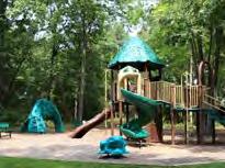
20 Glen Park Glen Park is a nine-acre park located in the northwest section of the City. The neighborhood park has an access walkway, play equipment, picnic tables and benches. Parking is located along Glen Park Drive and Highland Drive. Glen Park 2019 Draft Community Recreation Plan City of Rockford 14

21 Heritage Parkland and Nature Trail Heritage Park is a newer seven-acre park located in the northwest region of the City within the Heritage neighborhood. The park was created as part of the initial sub-division development. Facilities include a play area, restroom building, ½ basketball court, a paved pathway and natural areas. Heritage Parkland and Nature Trail - Prior to Development of Facilities 2019 Draft Community Recreation Plan City of Rockford 15


22 Heritage Park Highland Park is an 8.3 acre park that is an undeveloped natural area. Access to the park is only available from private property at this time. However, it is in the center of proposed future housing developments which will include public access to the park and provide green space within the expected density. Heritage Park 2019 Draft Community Recreation Plan City of Rockford 16
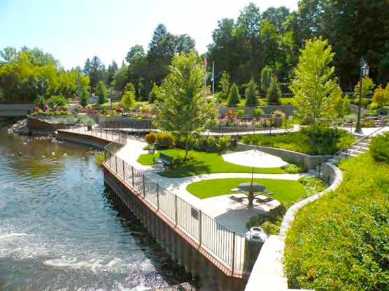
23 The Dam Area Parks: Including Peppler Park, Garden Club Park, the Dam, Portions of the Rogue River Trail and Frederik Meijer White Pine State Trail The Dam Area includes the walkway across the dam which connects to Peppler Park, the Dam Area Park, Garden Club Park, the Rogue River Trail and the Frederik Meijer White Pine State Trail. The dam walkway crosses the dam and provides a unique view up and down the Rogue River as well as the water flowing over the dam. The dam walkway also provides a unique connection between the western neighborhoods and the downtown. Dam Area Park is the small park located on the east side of the Rogue River and dam. This area provides the parking lot for the dam area, picnic tables, as well as a boardwalk overlooking the water. The boardwalk is used for river and dam viewing as well as by people fishing. Just north of the Dam Area Park is Garden Club Park. The Frederik Meijer White Pine State Trail is constructed on the old railroad right of way through Garden Club Park. Garden Club Park provides additional public river frontage above the dam, picnic areas and seating, as well as a small stage for summer concerts. Also located within Garden Club Park is the Michael F. Young Memorial. On the west side of the dam is Peppler Park. Peppler Park is a ½ acre park located on the banks of the river and comprised of a terraced walkway and seating areas. A connecting walkway provides access from the neighborhood to the dam, as well as public access to the river. The park is also the home of the Rockford Area Community Endowment Recognition Plaza. Directly north of Peppler Park is the Rogue River Nature Trail that is approximately 4.5 acres in size and extends as a linear park northward along the Rogue River. The trail has accessible pavement surfaces and boardwalks as well as fishing and wildlife observation platforms. See the aerial image on the next page of these areas. Proposed for construction in 2019 is the extension of the Rogue River Nature Trail to the south on the west side of the Rogue River from the bridge to 10 Mile Rd. This extension will include boardwalks, river access and viewing, and well as fishing opportunities Draft Community Recreation Plan City of Rockford 17


24 Dam Area Parks Peppler Park is located on the left or west side of the Rogue River and Garden Club Park is located on the right, or east side of the river. The Dam Overlook crosses the river in between the parks on each side Draft Community Recreation Plan City of Rockford 18

25 Memorial Park Located on twenty acres of land, Memorial Park is located in the northeast region of the City. The park has a paved pathway along Rum Creek that connects Northland Drive with N. Monroe Street. The pathway provides access to a quiet natural area that was otherwise not accessible to the general public. Facilities within the more active areas of the park include a large green space used for open play, picnic tables, benches, and parking lot. A soccer field used and maintained by the school district is located on the east end of the park. The baseball diamond is no longer in use. The Community Cabin located within the park is available for public events and rentals. The Community Cabin includes public restrooms, kitchen facilities, audio visual equipment, tables and chairs. Adjacent to the park is Parkside Elementary School with a play area and basketball courts. The park and school facilities blend together as a large recreational facility. Memorial Park 2019 Draft Community Recreation Plan City of Rockford 19

26 Pickett Park Pickett Park is a neighborhood park located on Gaylord Drive with play equipment, an open green play space, picnic tables, benches and a parking lot. The park also has a walkway that provides access from the neighborhood and parking lot to the Frederik Meijer White Pine State Trail and Richardson-Sowerby Park. Pickett Park Adjacent to Frederik Meijer White Pine State Trail and Richardson Sowerby Park 2019 Draft Community Recreation Plan City of Rockford 20
27 Richardson-Sowerby Park Richardson Sowerby Park is located south of the main downtown and dam area. The park encompasses nearly 13 acres and is located on both the east and west sides of the Rogue River which is connected by a pedestrian bridge. The park is also located adjacent to the Frederik Meijer White Pine State Trail. The east side of the park is accessible from a public downtown parking lot with a walkway under the Division Street (10 Mile) Bridge. Additional access is via a pedestrian walk from Division St. and from the pedestrian bridge. The east side facility has a large picnic pavilion, play area, restroom building, picnic tables, and benches. The west side of the park is linear along the Rogue River extending southward to the City Limits behind the residential homes. The Rogue River Nature Trail provides a paved pathway with docks for fishing and wildlife observation for public access to the Rogue River and a dog park. Access to the park is from the adjacent Frederik Meijer White Pine State Trail, from Longview Drive, from Pickett Park, or across the pedestrian bridge from the east side of the park. An aerial photo of the park is located on the next page Draft Community Recreation Plan City of Rockford 21

28 East and West Sides of Richardson-Sowerby Park 2019 Draft Community Recreation Plan City of Rockford 22

29 Rotary/Jaycees Park Rotary/Jaycees Park is a small park located within a central neighborhood area of the City. The park has a play area, basketball court, picnic tables, benches, an open green play space with soccer goal, and parking. In 2007 an adjacent lot located on Fremont Street was purchased to expand the park and provide for greater access and visibility from Fremont Street. This area is currently open lawn area. Rotary/Jaycees Park 2019 Draft Community Recreation Plan City of Rockford 23
30 Accessibility Assessments The Guidelines for the Development of Community Park, Recreation, Open Space and Greenway Plans prepared by the Michigan Department of Natural Resources Grant Management Division requires the completion of an Accessibility Assessment. This assessment was completed in each park during the individual park tours and the results are included in this plan section. Appendix D. Barrier Free Accessibility Requirements for Parks, within the guidelines booklet, provides the following written comments regarding parks and accessibility. Recreational areas, facilities, and programs play an important role in the life of the community; therefore it is essential that people with disabilities have an equal opportunity to enjoy these areas and any programs provided. Federal and state laws prohibit discrimination on the basis of disability, and these laws apply to parks and other recreation lands and programs controlled and operated by local units of government. The DNR has a strong commitment to barrier free recreational opportunities in our Departmentmanaged programs and facilities. This commitment extends to those communities that receive recreation grants. Under the state Utilization of Public Facilities by the Physically Limited Act (Public Act 1 of 1966, as amended) all facilities, including improved areas used for recreation, must meet the barrier free design requirements contained in the state construction code. Under this act, the administration and enforcement related to barrier free design requirements are vested in the local or state government agency responsible for issuing a building permit. If the project does not require a building permit, administration and enforcement of barrier free design requirements are 2019 Draft Community Recreation Plan City of Rockford vested in the Department of Labor and Economic Growth. Any request for an exception to the barrier free design requirements of the state construction code must be submitted to the Barrier Free Design Board, with the Department of Labor and Economic Growth ( ). The Barrier Free Design board has the responsibility to receive, review, and process requests for exceptions to barrier free design specifications; require appropriate equivalent alternatives when exceptions are granted; and receive, process, and make recommendations for barrier free design rules. The Department of Justice published revised regulations for Titles II and III of the Americans with Disabilities Act of 1990 ADA in the Federal Register on September 15, These regulations adopted revised, enforceable accessibility standards called 2010 ADA Standards for Accessible Design, 2010 Standards or Standards. The 2010 Stands set minimum requirements both scoping and technical- for newly designed and construed or altered state and local government facilities, public accommodations, and commercial facilities to be readily accessible to and usable by individuals with disabilities. The Federal stands have precedence over State codes. Because the state construction code does not apply to many recreation facilities, it is essential that you also be aware of and understands the existing federal guidelines covering these types of facilities. In July 2004, the federal Architectural and Transportation Barriers Compliance Board (known as the Access Board) issued updated guidelines, entitled the Americans with Disabilities Act Accessibility Guidelines (ADAAG), for new or altered facilities covered by the Americans with Disabilities Act of 1990 (Public Law ) or the Architectural barriers Act of 24
31 1968 (Public Law ). These guidelines should eventually be adopted as enforceable standards. Until that occurs, the existing ADAAG standards must be followed when the two conflict. ADA Accessibility Review of Each Park The MNDR further suggests within its Guidelines that the Recreation Inventory includes that each facility be compared to the 2010 ADA Standards for Accessible Design and at a minimum given a ranking from 1-5 with the following rankings: 1=none of the site elements meet the 2010 ADA Standards for Accessible Design. 2=some of the elements meet the Standards 3=Most of the elements meet the Standards. 4=All of the elements meet the Standards. 5=the facility meets the Principals of Universal Design. A tour of each park was completed regarding ADA accessibility. Parks that have been recently constructed are more accessible than older park improvements. All new park projects are being designed to meet or exceed the U.S. Government Americans with Disabilities Act standards for recreational facilities with an emphasis on Universal Accessibility. A summary of each park is given below. Cahill Park Cahill Park is currently undeveloped. If at some point the park is developed, the new facilities will be constructed to meet or exceed the current ADA standards. Rating: 1=none of the site elements meet the 2010 ADA Standards for Accessible Design Draft Community Recreation Plan City of Rockford Dam Area, Peppler Park and Garden Club Park This area includes all of the recreational lands on both the west side and east side of the dam as well as the walkway which crosses the dam. Facilities include accessible walks, fishing areas, benches, picnic tables, and parking. Most of these areas have been renovated and upgraded to meet ADA design standards. The Garden Club Park has not been renovated and still requires renovation to improve accessibility for picnic tables, benches, and the performance stage. Garden Club Park is the area planned to receive renovations in the future to further improve the overall dam and riverfront areas. Rating: 3=Most of the elements meet the Standards. Glen Park Glen Park is located within a residential neighborhood. Facilities include a walkway and playground. Both the walkway and the playground area are accessible. An informal pathway created over the years by residents in the wooded area is not accessible. If facilities are added, these will also be constructed to meet the current standards. Rating: 3=Most of the elements meet the Standards. Heritage Park Heritage Park is a park within the City developed by the residential developer and deeded to the City. The facilities include new accessible 25
32 restroom building, play area, paved pathway and a ½ court basketball court. The picnic tables are not accessible and require access pathways and concrete surfaces. The entrance pathway also appears to be steeper than 5% and requires a study as to the need of a handrail or other route. 2=some of the elements meet the Standards. Memorial Park Memorial Park is a historical park within the City. Over the last few years many of the facilities have been renovated and new facilities added. These include an accessible riverfront and wetland walkway, picnic tables, and benches. The Community Cabin rental lodge was renovated to include accessible restrooms accessed from the outdoors for park visitors as well as accessible restrooms and facilities within the Lodge. The open sports fields remain open green space. The adjacent playground at the elementary school was recently renovated to include new accessible playground equipment and accessible unitary surfacing. Rating: 3=Most of the elements meet the Standards. Pickett Park Picket Park was developed since the Americans with Disabilities Act and is a totally accessible park. The park has accessible parking, walkway with a connection to the Frederik Meijer White Pine State Trail, playground, benches and picnic tables. 4=All of the elements meet the Standards. south of downtown and adjacent to the Frederik Meijer White Pine State Trail. The east side of the river has accessible restrooms, walkways, and playground. The park is in need of more accessible picnic tables and benches. The riverbank is entirely mowed lawn. Accessible access to the picnic tables, benches, and closer access to the river is desirable. The dog park area could also be more accessible. The west side of the river has an accessible riverfront pathway with accessible fishing and wildlife viewing decks. The dog park is located on an old softball diamond that is retrofitted and is not fully accessible. Rating: 3=Most of the elements meet the Standards. Rotary/Jaycees Park Rotary/Jaycee Park is located within the adjacent residential neighborhood. Facilities include an accessible parking lot, walkways, playground equipment, basketball court, picnic tables and benches. There is also an open green space. 4=All of the elements meet the Standards. Rogue River Nature Trail The Rogue River Nature Trail through a MNRTF grant developed an accessible walkway with fishing and wildlife viewing decks. With these facilities completed in 2008, the facilities within the park meet accessibility guidelines. 4=All of the elements meet the Standards. Richardson-Sowerby Park Richardson-Sowerby Park is located on both sides of the Rogue River just 2019 Draft Community Recreation Plan City of Rockford 26

33 City of Rockford Trails & Linkages Map 2019 Draft Community Recreation Plan City of Rockford 27

34 Cannon Township Non-Motorized Trail Map 2019 Draft Community Recreation Plan City of Rockford 28

35 2019 Draft Community Recreation Plan City of Rockford 29
36 Rockford Public School Facilities The City of Rockford is entirely within the larger Rockford Public Schools System. The School District is very large and extends into several surrounding Townships and incorporates a total of 87 square miles. The school facilities located within the City of Rockford City Limits include the following and are shown on the City of Rockford Park and School Location Map which is located at the beginning of the Recreation Inventory Section. Within City Limits: North Rockford Middle School Located on the eastern edge of the City, facilities available for recreation include a swimming pool, gym, multipurpose room, eight tennis courts, four sand volleyball courts, lighted track, and a football/soccer field. Parkside Elementary School Parkside is located immediately adjacent to Memorial Park. Facilities available for recreational use include a large creative playground, two basketball courts, gym and multipurpose room. River Valley Academy River Valley Academy provides alternative education opportunities for students in grades nine through twelve. Facilities available for recreation include one ball diamond, soccer field, playground, gym, and multipurpose room. Valley View Elementary School Located in the northwest area of the City on thirteen acres of land, the school has a multi-purpose room, gym, ball diamond and a large playground Draft Community Recreation Plan City of Rockford Outside of the City Limits: Belmont Elementary School Located in Plainfield Township. This school has an outdoor hard surface court, a playground, two t-ball fields and an indoor gym. Crestwood Elementary School Located in Courtland Township south of Rockford. This school has a multi-purpose play field and a playground in addition to a gym Cannonsburg Elementary School Located in Cannon Township. This school has a playground and a multipurpose paved court surface and a multipurpose sports field. It also has a gym. Lakes Elementary School This school is located East of Rockford. The facilities include a playground, two baseball diamonds, a fitness course, paved court surface and a gym. Meadow Ridge Elementary School Located in Courtland Township, southeast of Rockford. This facility has a playground and an open lawn area. Roguewood Elementary School Located south of the city limits, This school has a playground, a paved multipurpose court, one full size soccer field and one small size soccer field. East Rockford Middle School This school has nine multi age baseball diamonds, a football field with surrounding track, eight tennis courts, full sized soccer field and four youth soccer fields. It also has a gym and an indoor pool. 30
37 Rockford High School This school is also located south of the City. Facilities include two baseball diamonds, two softball diamonds, eight tennis courts, one full sized soccer fields and two medium sized soccer fields. It also has a football field with surrounding track and practice fields. The indoor facilities include a swimming pool and two gyms. Rockford Freshmen Center Located adjacent to the High School, this facility has a baseball field, softball field, three small practice fields of various sizes, and a gym Draft Community Recreation Plan City of Rockford 31
38 Other Regional Public Recreation Sites and Facilities The City of Rockford is located in the northern region of the Grand Rapids Metropolitan Area within Kent County. Other nearby recreational opportunities include the following: Frederik Meijer White Pine State Trail, State of Michigan The Frederik Meijer White Pine State Trail is part of the statewide trail system under development by the Michigan Department of Natural Resources. The trail connects from the City of Cadillac into Comstock Park on the north side of Grand Rapids, totally approximately 90 miles of trail. The trail currently passes through the City of Rockford. Canonsburg State Game Area, State of Michigan Natural area for public use and hunting. Rogue River State Game Area, State of Michigan Natural area for public use and hunting. Luton Park, Kent County Over nine miles of interconnected trails for mountain biking, hiking, trail running, cross country skiing and snow shoeing with access to Rum Creek. Merrill Trail Six miles of interconnected trails for mountain biking with designated routes. Pickeral Lake County Park, Kent County Lake access including fishing, boardwalks, nature trails and natural areas. Rogue River County Park, Kent County River Access with fishing, picnicking, play area, and ball diamond. Lamoreaux County Park, Kent County Natural area with hiking and cross-country skiing Myers Lake Park, Courtland Twp. Playground, swimming, fishing, picnic area Townsend Park, Cannon Twp. Picnicking, playground, and fishing. Wabasis Park, Oakfield Twp. Picnicking, playground, fishing, swimming, and camping Camp Lake, Algoma Township Public access and fishing Lime Lake, Solon Township Public access and fishing Big Pine Island Lake, Grattan Twp. Public access and fishing Art Van Sports Complex, 10 Mile Road 12 ball fields and support facilities West Michigan Archery Center, 10 Mile Road Archery Range and Tournament facility McCarthy Lake, Gratton Twp. Public access and fishing Big Muskrat Lake, Gratton Twp. Public access and fishing 2019 Draft Community Recreation Plan City of Rockford 32

39 2019 Draft Community Recreation Plan City of Rockford 33
40 Rockford Public Schools Community Education The Rockford Public Schools District also provides numerous enrichment programs and classes through the Rockford Community Services funded through a special school millage and class fees. The types of classes change regularly to meet the interests of the community. Programs are offered for all ages including pre-school, school age, adults and seniors. Examples of programs are fitness, first aid, various arts and crafts, computer classes, cooking classes, after school enrichment classes, and senior trips and tours. Other Special Events Mitchell s Run is sponsored by a grass roots non-profit organization that raises money for Parent Project Muscular Dystrophy. Start of Summer, Harvest Festival, and the Santa Parade are sponsored by the Rockford Chamber of Commerce. Other Recreation Programs Offered by Non-Profit Organizations Rockford Little League The Rockford Little League provides youth baseball and softball leagues. AYSO Soccer, Basketball, and Volleyball Athletic leagues for boys and girls within the community for soccer, basketball, and volleyball. Rocket Football/78 ers Rocket Football provides youth football leagues within the community. Rockford Hockey Association A non-profit association that provides youth ice hockey leagues. Riptide Swimming Club Riptide Swimming Club provides youth swim teams in the Rockford area. SCOR Soccer The Soccer Club of Rockford provides youth soccer leagues. Rockford Boys Lacrosse Club Instruction and play for youths up to eighth grade Rockford Girls Lacrosse Club Instruction and play for youths up to eighth grade 2019 Draft Community Recreation Plan City of Rockford 34
41 MDNR Recreation Grant Inventory The City of Rockford has received numerous grants administered by the Michigan Department of Natural Resources over the last several years. These grants have added many successful facilities for the residents to enjoy. The City of Rockford does not have Project No.: H1 (1980) Project Title: Richardson Park Grant Amount: $35, Status: Completed and Closed Out Constructed: 1981 Current Use: Richardson Park is an active park used daily by residents and is adjacent to the Frederik Meijer White Pine State Trail. Additional facilities have been added to the park since the completion of the grant. Project No.: TF903 (1984) Project Title: Rogue River Frontage Grant Amount: $20, Status: Completed and Closed Out Constructed: Land Purchase Current Use: The river frontage is part of the public park properties and is actively used by residents throughout the year. Project No.: (1986) Project Title: Rockford Peppler Park Grant Amount: $15, Status: Completed and Closed Out Constructed: Boardwalk and walkways, picnic tables and benches. Current Use: Peppler Park is located on the west side of the river at the dam. The park is used for shore fishing from a boardwalk, picnicking, and viewing of the dam and river. In 2007 additional improvements were made to the park which increased ADA accessibility, additional seating, gardens and recreational use Draft Community Recreation Plan City of Rockford any open grant projects at the writing of this plan. Completed Post-Completion Self Certification Report PR1944 sheets are located in Appendix A. A summary of the Projects is given below: Project No. BF (1989) Project Title: Richardson-Sowerby Park Status: Completed and Closed Out Grant Amount: $30, Constructed: Public restrooms, fitness trail, and walkways Current Use: The park is located on the Rogue River and provides public access to the river including picnic areas, a restroom building, and a playground. The park is maintained and used throughout the year. Project No: (1992) Project Title: Dam Island Improvements Grant Amount: $28, Status: Completed and Closed Out Constructed: Walkways, railings and seating to connect both sides of the river bank across the dam. Current Use: The dam remains the focus of downtown Rockford. The dam island connects the east and west sides of the river over the dam. This area is used by people viewing the river and dam as well as people fishing. Additional improvements to both the east and west parklands have also been made after the completion of the grant. 35
42 Project No.: TF (1997) Project Title: Rogue River Overlook & Fishing Improvements Grant Amount: $92, Status: Completed and Closed Out Constructed: Improvements to the east bank of the Rogue River at the dam including fishing access, picnic area, tables, and parking. Current Status: The east side of the dam is used daily by residents and visitors. The park connects to the Frederik Meijer White Pine Trail, the dam and the other riverfront pathways. Project No: CM (2000) Project Title: Rum Creek Nature/Fitness Trail Development Grant Amount: $95, Status: Completed and Closed Out Constructed: Pathway, boardwalk, bridge, picnic tables, benches and drinking fountain. Current Use: The Rum Creek Trail is located within Memorial Park. The park is actively used for youth leagues and by the adjacent elementary school. Additional improvements to the park have included the renovation of the Community Cabin to include accessible restrooms for park visitors as well as a rental lodge. Project No.: TF (2003) Project Title: Rogue River Trail Network Grant Amount: $118, Status: Completed and Closed Out Constructed: Pathway, fishing decks and site amenities Current Use: Riverside pathway along the Rogue River within Richardson-Sowerby Park including fishing docks. The pathway also links to the Frederik Meijer White Pine State Trail, Pickett Park, and the downtown. Project No.: TF (2006) Project Title: Rogue River Trail Network Extension-Peppler Park Grant Amount: $222, Status: Completed and Closed Out Constructed: Boardwalk pathway along the west side of the Rogue River including wildlife and fishing observation decks. Current Use: The pathway is open to the public. Project No.: TF (2010) Project Title: Rogue River Nature Trail Development Grant Amount: $86, Status: Completed and Closed Out Constructed: Continuation of the nature trail and boardwalk with connection to the northwest neighborhoods, White Pine State Trail and the Downtown. Current Use: The pathway is open to the public. Project No.: TF (2017) Project Title: Rogue River Nature Trail Development Grant Amount: $240, Status: Construction Expected in 2019 Constructed: To be Constructed in 2019: Approximately 600 feet of boardwalk, two fishing platforms, some lighting around the parking area, picnic tables, recycle bin, and signage will be constructed. Current Use: Casual Park Use 2019 Draft Community Recreation Plan City of Rockford 36
43 Goals and Objectives Section The Goals and Objectives Section of the plan provides an overriding vision for the future of parks and recreation within the community. These goals are based on public input for current and future recreational opportunities. Each Goal is further defined by the Objectives that follow. The Action Plan section of this plan determines proposed projects and programs that aid in meeting these Goals and Objectives. Goal Number 1: To provide multi-generational recreational opportunities within the community as the City is comprised of persons of all ages. Objectives: a. To provide facilities and open park lands that provide recreational opportunities for all ages. b. To allow for all persons of multiple generations, extended family groups, and large groups to universally enjoy nature preserves parks, facilities, and programs. Goal Number 2: To provide recreational facilities and programs for persons of all mental and physical abilities. Objectives: a. To renovate existing facilities and develop new facilities that meet or exceed the Americans with Disabilities Act (ADA) that will expand recreational opportunities for all residents. b. To renovate existing facilities and develop new facilities that integrate accessible accommodations in such a way that they are seamlessly used by all residents within the community and do not cause separation of users based on abilities. Goal Number 3: As residential growth continues within the City, the outdoor areas owned by the City continue to grow in significance and face increased public usage. The City will continue to provide diversified outdoor experiences for the residents. Objectives: a. The City will retain all dedicated park lands for the use and enjoyment of residents. The City will not convert existing park lands into non-recreational uses. b. The City will continue to protect and plan for the best usage of natural areas including woodlots, natural vegetation, and river frontage. c. The City will purchase, or receive as gifts, additional park lands as deemed appropriate to continue to 2019 Draft Community Recreation Plan City of Rockford 37
44 2019 Draft Community Recreation Plan City of Rockford expand recreational lands for the use of City residents. Goal Number 4: To continue to provide, as much as possible, maximum use of the parks and facilities by residents. Objectives: a. To continue to allow for open use of the park lands and to not charge admission into the facilities to provide for general public recreational opportunities for all residents regardless of economic status. b. To minimally charge, as required, for special events and athletic field maintenance to keep the facilities available for general public use. Goal Number 5: To continue the development of the Non- Motorized Pathway System within the City for the purpose of providing for healthy lifestyles through exercise, enjoyment of the environment, and as a non-motorized transportation system linking homes, schools, parks, and commercial areas. Objectives: a. To continue to expand the system providing additional linkages. b. To whenever possible link the system of pathways and trails to other planned county, state, regional, and surrounding community s non-motorized systems, including the Frederik Meijer White Pine State Trail. c. To maintain a master plan for pathway and sidewalk development which includes both the City system and regional proposed pathways linking parks, schools, neighborhoods, and commercial areas. d. To evaluate on-street bikeways as connectors to meet the growing needs of non-motorized vehicles and to utilize the existing parks and trail access points to leverage economic growth and quality of life within the community. Goal Number 6: To actively manage and maintain the City s park land to maximize appropriate use and appearance of park property. Goal Number 7: To support, as appropriate, non-profit organizations and citizens who choose to provide recreational facilities and programming for the residents. Objectives: a. To support a balance of programming for all ages within the community. b. To support programming to address social concerns such as senior and preschool populations, after 38
45 school programs, and community health. c. To continue to support programs and special events which are jointly supported by public schools, nonprofits, and civic organizations. d. To encourage recreational and cultural events, history, arts, and music within the community, which also support economic development within the community. c. To actively seek grants and other outside funding sources to support existing and new programs and facilities. Goal Number 9: To seek opportunities for collaboration with surrounding governmental agencies to provide recreational facilities and programs which are most appropriate for serving the regional area. e. To encourage and support park facility development within the parks by citizens and community non-profit organizations. Goal Number 8: To effectively provide financial resources for the development and maintenance of the park facilities. Objectives: a. To provide funding for capital development projects which allow the renovation of existing facilities and the development of new facilities that meet changing recreational needs and desires. b. To collect user fees as appropriate to off-set the overall cost of use to the public facilities Draft Community Recreation Plan City of Rockford 39
46 2019 Draft Community Recreation Plan City of Rockford 40
47 Action Program Section The Action Program Section provides a written description of the overall vision for the future development of park lands within the City of Rockford. The Planning Commission participated in the development of the Action Program through leading public participation, review of ideas, development of the Goals and Objectives, and prioritization of future projects and developments. Land Acquisition Several pieces of property have been designated as key pieces for the development of the park system within the City of Rockford. Some of these desired lands have been included in previous plans and remain a priority. At this time these pieces of property are not available for sale, but will be considered as they become available. Residential Property North Side of Pickett Park The residential property with a house and yard, located on the north side of Pickett Park between the park and 10 Mile Road/West Division Street, will be a strong asset to the park. The property will provide additional riverfront property for the City, space for additional park amenities, and room for additional parking. Since the park opened in the 1990's the park has grown in popularity in providing not only a neighborhood park, but also direct access to Richardson-Sowerby Park, the Rogue River Nature Trail, and the Frederik Meijer White Pine State Trail. The acquisition of the property will more than double the existing park. The property owner is aware of the City's interest in the property. Property Between Rogue River and Frederik Meijer White Pine State Trail West of the North Industrial Park is an undeveloped natural wooded parcel with wetlands. The west side of the property has substantial frontage on the Rogue River and the east side of the property is adjacent to the Frederik Meijer White Pine State Trail. The acquisition will also provide a substantial addition to the publicly owned Rogue River frontage and natural areas within the City limits. Squire Property The Squire Property is located adjacent to the City on the south side of 12 Mile Road, west of Northland Drive. The property is adjacent to the Frederik Meijer White Pine State Trail, has natural areas and a pond, and will provide a route for the construction of a pedestrian connector between Shaw Estates and the Frederik Meijer White Pine State Trail. Rotary/Jaycee Park Additional Entrance Acquisition of a piece of land or an easement on another side of the park, other than Fremont St., will provide a second public access into the park and easier access for residents living west of the park Draft Community Recreation Plan City of Rockford 41
48 Capital Development Projects All of the project ideas collected throughout the planning process were reviewed and discussed by the Planning Commission. Based on the discussions, the projects were divided into lists of High Priority Projects, Medium Priority Projects and Low Priority Projects. This prioritization allows the City to best direct its resources towards the projects receiving the highest priority rankings. The Project Priority List reflecting these priorities in the following chart Draft Community Recreation Plan City of Rockford 42


49 2019 Draft Community Recreation Plan City of Rockford 43

50 Park Location Map for Referencing Projects 2019 Draft Community Recreation Plan City of Rockford 44
51 High Priority Project Descriptions Below, a brief written description is provided for each of the High Priority Projects. The High Priority Projects have been determined to be the most important projects to focus on first within the community. The projects are listed in alphabetical order by park. Downtown Riverfront-West Side of Rogue River from Bridge St. to 10 Mile Rd. Located just south of Bridge Street, and on the west side of the Rogue River, the West Riverfront is a popular area of river frontage. The site is currently used by the public for a variety of uses that have increased over time as the popularity of the downtown and the riverfront has increased. Although directly adjacent to the downtown, this area has a more natural character. Improvements and uses of the site include on-street pull off parking, a rough stairway path to the river, shoreline fishing, informal drop-in boat launching, enjoyment of the wooded area, and as a foot pathway connector from the Frederik Meijer White Pine State Trail to the dam area, downtown, and adjacent neighborhoods linking between Richardson- Sowerby Park and the Dam Area Park. In 2013, a new master plan for the proposed refinement of this area was developed. The proposed development will provide for an ADA accessible boardwalk and pathway from the Bridge St. area down the riverbank to the lower river bank area. A Rogue River viewing and fishing platform, or surface, will be provided to provide ADA accessibility to this area. An informal natural pathway, out of materials such as crushed limestone, will be utilized on the wider riverbank area to provide an informal and more natural pathway to the newly renovated Blakeslee Creek, as well as shoreline fishing, and informal picnicking. An informal stairway and pathway will be reconstructed from the parking area to the lower bank to continue to allow informal hand carried canoe and kayak launching in a drop in method, without a dock or launch facility. The naturalized pathway will continue southward until it reaches a point where boardwalk is once again required to continue under the 10-Mile Bridge and connect across the ravine to Pickett Park and the Frederik Meijer White Pine State Trail. Based on the master plan, a MNRTF grant application was developed and approved by the MDNR for the project to develop the pathway from Bridge St to 10 Mile Rd. The project has been designed and bid. Construction of the project is expected to be completed in The last linkage needed will be between 10 Mile Rd and Pickett Park. The City is currently attempting to negotiate for the missing property to make this connection. Garden Club Park Renovation & Power House Garden Club Park is located in the downtown on the east bank of the Rogue River at the dam. It is the hub of downtown activity on the river connecting the downtown, dam areas, and the Frederik Meijer White Pine State Trail. As popularity of the park has grown, so has the desire to redevelop the park. The area within the park has also recently increased with the acquisition and demolition of buildings located on the edge of this park expanding the land within this core area. Proposed as the highest priority for this park is the development of a new master plan for the park which will incorporate a public design process, to develop a new vision for this beloved space. New facilities being considered include a performing arts stage, public restrooms, a fountain/splash play area, outdoor winter skating, outdoor fireplace, river viewing, ADA accessible 2019 Draft Community Recreation Plan City of Rockford 45
52 canoe & kayak launch, retention of shore fishing areas, parking, and other multiseasoned related activities. The new master plan will provide for a phased vision for the park, help identify priorities, provide conceptual cost estimates, and provide planning for future recreational programming. Heritage Park Pathway Expansion, Repair, Signage, and Park Identification An existing paved pathway within Heritage Park will be extended to provide a longer pathway system as well as to link the proposed play field and play area to the rest of the park. The existing pathway system will be improved with pathway way-finding signage to help designate distances and directions to points of interest. The existing park is an irregular shape and it is often difficult to determine the boundaries of the parkland. This will be improved through the addition of boundary signage and signage at the public entrances into the park. The existing pathways are beginning to age and will be requiring repair and renovation over the upcoming years. Pickett Park Improvements Additional tree plantings will be added to Pickett Park to provide both screening of neighboring residential yards and to increase the amount of shade available in the park at the play area and for picnicking. Additional picnic tables and a drinking fountain are desired to increase the enjoyment by both neighborhood and trailhead visitors to the park. Richardson-Sowerby Park Improvements There is the potential of adding a splash pad within Richardson-Sowerby Park with several positives noted, being the downtown location, adjacent parking, existing restrooms, picnic pavilion, and access to the White Pine Trail. Other items to be evaluated include that the park is not as well 2019 Draft Community Recreation Plan City of Rockford known since it is not as visible as other parks, the nearby dog park as to whether this might be a concern, available space within the park, and investigating available utilities needed for the operation. A study needs to be completed for a preliminary design to determine both the public desire for the splash pad at this location and the feasibility for construction. Additional tree plantings will be added to Richardson-Sowerby Park to increase the overall shade canopy within the park. As an older park, some of the trees are declining while some areas have never been planted. The tree plantings will provide additional shade for picnicking and along the Rogue River Nature Trail. A recent new addition to the park has been a Dog Park that is very popular with residents. The addition of a Dog Agility Course within the Dog Park is desired to provide additional exercise and challenges for both the dogs and their partners. Rotary Park Restroom The addition of restroom facilities within Rotary Park is desired within the neighborhood park. A variety of restroom facility options have been discussed for this park including traditional flush toilet buildings as well as seasonal portable toilets located on concrete surfaces with shelters. A final determination will be made at the time of implementation. Pathways-Linkage of Rum Creek Trail to the Frederik Meijer White Pine State Trail and Re-naturalization of Rum Creek This project will provide a pathway connection between two existing trails within the City of Rockford. Rum Creek, between Memorial Park and the Rogue River, is currently contained in underground piping for most of the distance. This proposed project will remove the piping and reestablish the creek as an open, natural water body with a pedestrian and bicycle 46
53 pathway located along the side of the pathway. This project will improve the overall water quality of Rum Creek, provide a more natural environment within the City, and provide a trail connection for neighborhoods along the trail as well as future eastward connections of the trail systems within the City of Rockford and Courtland Township. The re-naturalization of Rum Creek will also provide opportunities for expanding fish habitat including breeding areas for significant game fish, including trout, found within the Rogue River watershed. Pathways-Connecting Bridge over the Rogue River A new bridge is proposed over the Rogue River to provide a northern pedestrian crossing linking the east and west sides of the river. This bridge will make many connections for pedestrian routes easier and provide expanded access to the City s Park System. Pathways-Linkage of Frederik Meijer White Pine State Trail to the Art Van Sports and Archery Complexes Located Near US-131 This project will develop a connecting nonmotorized trail between the existing Frederik Meijer White Pine State Trail, located within the City of Rockford, to the new Art Van Sports Complex area located west of town on 10 Mile Road near the US- 131 expressway. The sports complexes and activities provide a complex of twelve ball fields with supporting facilities, an archery range with tournament facility, BMX competition facilities, off-road bicycle trails, and other related recreational facilities generating non-motorized traffic both into and out of the City and surrounding Townships. Pathways-Linkages to Courtland Township Through master planning efforts, determine potential routes for connecting proposed trails within Courtland Township, on the east side of Rockford, to the trails within the City of Rockford. These trails include Rum Creek, the Frederik Meijer White Pine State Trail, and possibly other routes that have not yet been determined Disc Golf Course A disc golf course within the City has been discussed as a desirable facility available for recreation for a wide variety of ages, but with a particular interest within the youth and young adult age groups. A location that will accommodate a course has not been identified. Extend the Waterfront Development Northward on East Side of River The downtown development can be extended northward along the east side of the river redeveloping old industrial areas into new recreational and commercial uses. This redevelopment can be supported by the redevelopment of the Wolverine Property, waterfront recreational development of Garden Club Park, the Trail, the Rum Creek Connector, and the Northend Sub-Area Plan Draft Community Recreation Plan City of Rockford 47
54 City of Rockford North End Subarea Plan The North End Subarea Plan provides a focused redevelopment master plan for the north end of town on the east side of the Rogue River. This redevelopment includes, and will influence, the development of recreational facilities, trails, residential, and commercial land uses. This plan will oversee the largest integrated redevelopment to take place within the City of Rockford since its beginning. The North End Subarea Plan is included for reference on the following pages Draft Community Recreation Plan City of Rockford 48

55 2019 Draft Community Recreation Plan City of Rockford 49

56 2019 Draft Community Recreation Plan City of Rockford 50

57 2019 Draft Community Recreation Plan City of Rockford 51

58 2019 Draft Community Recreation Plan City of Rockford 52

59 2019 Draft Community Recreation Plan City of Rockford 53

60 2019 Draft Community Recreation Plan City of Rockford 54

61 2019 Draft Community Recreation Plan City of Rockford 55

62 2019 Draft Community Recreation Plan City of Rockford 56

63 2019 Draft Community Recreation Plan City of Rockford 57

64 2019 Draft Community Recreation Plan City of Rockford 58

65 2019 Draft Community Recreation Plan City of Rockford 59

66 2019 Draft Community Recreation Plan City of Rockford 60

67 2019 Draft Community Recreation Plan City of Rockford 61

68 2019 Draft Community Recreation Plan City of Rockford 62

69 2019 Draft Community Recreation Plan City of Rockford 63

70 2019 Draft Community Recreation Plan City of Rockford 64

71 2019 Draft Community Recreation Plan City of Rockford 65

72 2019 Draft Community Recreation Plan City of Rockford 66

73 2019 Draft Community Recreation Plan City of Rockford 67

74 2019 Draft Community Recreation Plan City of Rockford 68
75 Planning and Public Input Section The Planning and Public Input Section includes a description of the process completed in the development of the plan. This information includes the key steps in the process, public input into the plan, prioritization of recreational needs, public review of the adoption, formal adoption of the plan, and distribution of the plan to concerned agencies. Key Persons Involved in the Process Key persons included in the planning process were City staff, the City of Rockford Planning Commission, the general public, and the City of Rockford City Council. The involvement of each of these groups is given in more detail in the information below. City of Rockford Planning Commission The Planning Commission led the process for updating the Community Recreation Plan from initial discussions through recommendation of the plan for adoption by the City Council. Tour of Existing and Potential Parks Properties and Review of Facilities A tour was conducted of each of the park properties and a review was completed of the existing facilities including natural resources, an inventory of facilities, current conditions, ideas for possible future facilities, and a review of Americans with Disabilities (ADA) criteria for universal accessibility within the parks. Also, undeveloped properties desirable for future recreational use were evaluated for potential acquisition. Americans with Disabilities Act and Universal Accessibility Review During the individual park tours, each park was reviewed for providing better universal accessibility to all of the parks. This information was reviewed concerning the MDNR review standards for Community Recreation Plans, as well as a more specific listing of facility upgrades for each park to increase accessibility. The findings of this review are included in the individual park descriptions included in the Recreation Inventory Section of the plan. Two Community Workshops Two workshops were held to invite and collect public input into the planning process. The first, Pizza & Parks Open House, was held on October 18, 2018 from 5:00 p.m.-7:00 p.m. at the Community Cabin in Memorial Park. A full summary of the event appears on the following pages. The second event was held as a stakeholder invited event on November 13, 2018 from 5:00 p.m.-6:30 p.m. which was hosted by the Planning Commission with invited community stakeholders to review the community input and assist with the prioritization of future priorities for the Action Plan. The results of this meeting is incorporated into the formal Action Plan of this document Draft Community Recreation Plan City of Rockford 69


76 Pizza & Parks Open House As part of the planning process the City held a Pizza & Parks Open House to encourage public participation into the planning process for the updating of the Recreation Plan. The event was advertised on the City s Facebook page and through an advertisement in the local paper. The event was held at the Community Cabin located in Memorial Park on October 18, 2018 from 5:00-7:00 with a drop-in open house format for all ages within the community. The event was attended by approximately forty people Draft Community Recreation Plan City of Rockford 70

77 The format for the open house was a casual drop-in format with several different types of opportunities for residents young and old to express their thoughts regarding their visions for the future of parks and recreation within the Rockford community. Ideas and thoughts collected at the meeting included the following desires: An expressed desire for more parks on the East side of the City. A desire for pickle ball courts and stadium A gaga ball pit A Splash Pad The addition of a disc golf course Cement ping pong table Soccer field Kick Ball An ADA Kayak Launch Better play field at Memorial Park Bigger Kid Activities such as a zip line, rock climbing wall, and splash pad Post Park/Trail map at every Park/Trail head Draft Community Recreation Plan City of Rockford 71

78 Heritage Park-provide public access and develop for everyone to use. Memorial Park-Repurpose the baseball diamond with a skateboard park, pickle ball, and splash pad. Provide more benches, zip line over the stream, rock climbing wall, inline skating rink, ninja warrior course, four square. Dam Area Parks-Add hockey rink, splash pad, dances, add a clear wall to see underwater, a city fish cam. Richardson-Sowerby Park-improvements to the steep walk down the hill for safer access, trampoline, a treehouse, pickleball. Pickett Park-Drinking fountain, picnic tables, more play equipment Rotary/Jaycees Park-Access from Ogden or Monroe to park, restrooms, pickleball Cahill Park-We like the park undeveloped. We would like to add a parking lot and walking trails, pickleball Dog Park-Add an agility course. Dog Pool Area by the Dog Park. Numerous potential trail linkages were also discussed for linking neighborhoods, the High School, and regional trails. Public Notice from The Rockford Squire Newspaper, printed October 11, Draft Community Recreation Plan City of Rockford 72
79 Planning Commission Planning Process The Planning Commission met several times during the planning process to review the public comments received, review committee member ideas, develop goals and objectives, and oversee the development of the plan document. These meetings were during Regular and Special Planning Commission meetings. Electronic Public Survey An electronic public survey was conducted using a Survey Monkey format. The survey was made available to the public via the City s Facebook site, City s website, and other public announcements. The survey was open for comment from October 1, 2018 through November 30, A total of 513 responses were received to the survey of which 77% were from City residents and 23% were from non-residents. The complete results of the survey are included in Appendix B. Development of Goals and Objectives and Action Plan Draft Goals and Objectives were reviewed by the Planning Commission and incorporated into the document. The Action Plan was developed by the Planning Commission with input from a Community Stakeholder group that reviewed the proposed projects generated from the Goals and Objectives, park tours, public meetings, public survey and discussions. Development of Plan Draft A draft plan was completed for review by the Planning Commission. After an initial City staff and Planning Commission review was completed, the plan was made available to the public for review. The final draft was made available for the Public Hearing and final adoption by the City Council. 30 day Review Period and Public Hearing The draft plan document was advertised for public comment from December, 2018 through January, 2019 with the plan available for review and comment at the Rockford City Hall, the, and on the City's website. The public notice appears below. INSERT PUBLIC NOTICE Planning Commission Recommendation for Adoption The Planning Commission on passed a motion of support for the plan. INSERT RESOLUTION 2019 Draft Community Recreation Plan City of Rockford 73
80 Public Hearing Notice and Minutes A public hearing was held prior to the adoption of the plan on. A copy of the advertisement and minutes of the meeting are included below. INSERT NOTICE AND MINUTES City Council Adoption The plan was adopted by City Council on February 10, 2014 and a copy of the resolution is included below. INSERT RESOLUTION 2019 Draft Community Recreation Plan City of Rockford 74

81 MDNR Certification Checklist 2019 Draft Community Recreation Plan City of Rockford 75

82 2019 Draft Community Recreation Plan City of Rockford 76
83 Transmittal to West Michigan Planning Commission A copy of the Community Recreation Plan was transmitted to West Michigan Planning Commission for their use in future planning. Transmittal to Kent County Parks A copy of the plan was transmitted to Kent County Parks for their use in future planning efforts. Appendices 2019 Draft Community Recreation Plan City of Rockford 77
84 2019 Draft Community Recreation Plan City of Rockford 78
85 Appendix A Post Completion Certification Forms for Previous MDNR Grants 2019 Draft Community Recreation Plan City of Rockford 79
86 GRANT TYPE: (Please select one) Michigan Department of Natural Resources - Grants Management PUBLIC OUTDOOR RECREATION GRANT POST-COMPLETION SELF-CERTIFICATION REPORT This information required under authority of Part 19, PA 451 of 1994, as amended; the Land and Water Conservation Fund Act of 1965, 78 Stat. 897 (1964); and Part 715, of PA 451 of 1994, as amended. MICHIGAN NATURAL RESOURCES TRUST FUND CLEAN MICHIGAN INITIATIVE LAND AND WATER CONSERVATION FUND RECREATION PASSPORT BOND FUND GRANTEE: City of Rockford PROJECT NUMBER: H1 PROJECT TYPE: Development PROJECT TITLE: Neighborhood Park Improvements PROJECT SCOPE: Playground Development TO BE COMPLETED BY LOCAL GOVERNMENT AGENCY (GRANTEE) Name of Agency (Grantee) Contact Person City of Rockford Thad Beard Address 7 South Monroe Street City, State, ZIP Rockford, MI SITE DEVELOPMENT Telephone tbeard@rockfrod.mi.us Title City Manager Any change(s) in the facility type, site layout, or recreation activities provided? If yes, please describe change(s). Yes No Park facilities include a play area, restroom, and picnic facility with access pathways. All facilities have been renovated from the initial developments. Has any portion of the project site been converted to a use other than outdoor recreation? If yes, please describe what portion and describe use. (This would include cell towers and any non-recreation buildings.) Yes No Are any of the facilities obsolete? If yes, please explain. Yes No Yes, the play area has been replaced with a new walkway, new playground equipment and wood mulch safety surfacing. SITE QUALITY Is there a park entry sign which identifies the property or facility as a public recreation area? If yes, please provide a photograph of the sign. If no, please explain. Yes No Are the facilities and the site being properly maintained? If no, please explain. Yes No The facilities are maintained by the City of Rockford. Is vandalism a problem at this site? If yes, explain the measures being taken to prevent or minimize vandalism. Yes No Page 1 PR1944 (Rev. 07/07/2014)
87 POST COMPLETION SELF-CERTIFICATION REPORT - CONT D Is maintenance scheduled on a regular basis? If yes, give schedule. If no, please explain. Yes No The park receives weekly maintenance throughout the summer and weekly maintenance during fall, winter, and spring. GENERAL Is a Program Recognition plaque permanently displayed at the site? If yes, please provide a photograph. (Not required for Bond Fund Grants) Yes No N/A Is any segment of the general public restricted from using the site or facilities? (i.e. resident only, league only, boaters only, etc.) If yes, please explain. Yes No Is a fee charged for use of the site or facilities? If yes, please provide fee structure. Yes No What are the hours and seasons for availability of the site? The park is open year round from 8:00 a.m. to 10:00 p.m. COMMENTS (ATTACH SEPARATE SHEET IF MORE SPACE IS NEEDED) Page 2 PR1944 (Rev. 07/07/2014)
88 POST COMPLETION SELF-CERTIFICATION REPORT-CONT'D CERTIFICATION I do hereby certify that I am duly elected, appointed and/or authorized by the Grantee named above and that the information and answers provided herein are true and accurate to the best of my personal knowledge, information and belief. Thad Beard Please pri nt ~& f7 Grantee Authorized Signature December 1, 2018 Date Send completed report to: POST COMPLETION GRANT INSPECTION REPORTS GRANTS MANAGEMENT MICHIGAN DEPARTMENT OF NATURAL RESOURCES PO BOX30425 LANSING Ml Page3 PR1944 (Rev. 07/07/2014)
89
90 GRANT TYPE: (Please select one) Michigan Department of Natural Resources - Grants Management PUBLIC OUTDOOR RECREATION GRANT POST-COMPLETION SELF-CERTIFICATION REPORT This information required under authority of Part 19, PA 451 of 1994, as amended; the Land and Water Conservation Fund Act of 1965, 78 Stat. 897 (1964); and Part 715, of PA 451 of 1994, as amended. MICHIGAN NATURAL RESOURCES TRUST FUND CLEAN MICHIGAN INITIATIVE LAND AND WATER CONSERVATION FUND RECREATION PASSPORT BOND FUND GRANTEE: City of Rockford PROJECT NUMBER: PROJECT TYPE: Development PROJECT TITLE: Boardwalk, walkways, picnic tables and benches PROJECT SCOPE: West Side of Dam-boardwalk, walkways, picnic tables and benches TO BE COMPLETED BY LOCAL GOVERNMENT AGENCY (GRANTEE) Name of Agency (Grantee) Contact Person City of Rockford Thad Beard Address 7 South Monroe Street City, State, ZIP Rockford, MI SITE DEVELOPMENT Telephone tbeard@rockfrod.mi.us Title City Manager Any change(s) in the facility type, site layout, or recreation activities provided? If yes, please describe change(s). Yes No Facilities include baordwalk with fishing access, ramped walkway, picnic tables and benches, and walk connectoins. Has any portion of the project site been converted to a use other than outdoor recreation? If yes, please describe what portion and describe use. (This would include cell towers and any non-recreation buildings.) Yes No Are any of the facilities obsolete? If yes, please explain. Yes No SITE QUALITY Is there a park entry sign which identifies the property or facility as a public recreation area? If yes, please provide a photograph of the sign. If no, please explain. Yes No Are the facilities and the site being properly maintained? If no, please explain. Yes No The facilities are maintained by the City of Rockford. Is vandalism a problem at this site? If yes, explain the measures being taken to prevent or minimize vandalism. Yes No Page 1 PR1944 (Rev. 07/07/2014)
91 POST COMPLETION SELF-CERTIFICATION REPORT - CONT D Is maintenance scheduled on a regular basis? If yes, give schedule. If no, please explain. Yes No The park receives daily & weekly maintenance throughout the summer and weekly maintenance during fall, winter, and spring. GENERAL Is a Program Recognition plaque permanently displayed at the site? If yes, please provide a photograph. (Not required for Bond Fund Grants) Yes No N/A Is any segment of the general public restricted from using the site or facilities? (i.e. resident only, league only, boaters only, etc.) If yes, please explain. Yes No Is a fee charged for use of the site or facilities? If yes, please provide fee structure. Yes No What are the hours and seasons for availability of the site? The park is open year round from 8:00 a.m. to 10:00 p.m. COMMENTS (ATTACH SEPARATE SHEET IF MORE SPACE IS NEEDED) Page 2 PR1944 (Rev. 07/07/2014)
92 POST COMPLETION SELF-CERTIFICATION REPORT CONT'D CERTIFICATION I do hereby certify that I am duly elected, appointed and/or authorized by the Grantee named above and that the information and answers provided herein are true and accurate to the best of my personal knowledge, information and belief Thad Beard Please pri nt ~ -e----t~ December 1, 2018 Date Christine Bedford Please print December 1, 2018 Date Send completed report to: POST COMPLETION GRANT INSPECTION REPORTS GRANTS MANAGEMENT MICHIGAN DEPARTMENT OF NATURAL RESOURCES PO BOX LANSING Ml Page 3 PR1944 (Rev. 07/07/201 4)
93
94 GRANT TYPE: (Please select one) Michigan Department of Natural Resources - Grants Management PUBLIC OUTDOOR RECREATION GRANT POST-COMPLETION SELF-CERTIFICATION REPORT This information required under authority of Part 19, PA 451 of 1994, as amended; the Land and Water Conservation Fund Act of 1965, 78 Stat. 897 (1964); and Part 715, of PA 451 of 1994, as amended. MICHIGAN NATURAL RESOURCES TRUST FUND CLEAN MICHIGAN INITIATIVE LAND AND WATER CONSERVATION FUND RECREATION PASSPORT BOND FUND GRANTEE: City of Rockford PROJECT NUMBER: TF (2003) PROJECT TYPE: Development PROJECT TITLE: Rogue River Trail Network PROJECT SCOPE: Pathway and Fishing Docks TO BE COMPLETED BY LOCAL GOVERNMENT AGENCY (GRANTEE) Name of Agency (Grantee) Contact Person City of Rockford Thad Beard Address 7 South Monroe Street City, State, ZIP Rockford, MI SITE DEVELOPMENT Telephone tbeard@rockfrod.mi.us Title City Manager Any change(s) in the facility type, site layout, or recreation activities provided? If yes, please describe change(s). Yes No Grant facilities include riverfront pathway, fishing docks, and benches. Other facilities include a dog park and connections to the Rogue River Nature Trail. Has any portion of the project site been converted to a use other than outdoor recreation? If yes, please describe what portion and describe use. (This would include cell towers and any non-recreation buildings.) Yes No Are any of the facilities obsolete? If yes, please explain. Yes No SITE QUALITY Is there a park entry sign which identifies the property or facility as a public recreation area? If yes, please provide a photograph of the sign. If no, please explain. Yes No Are the facilities and the site being properly maintained? If no, please explain. Yes No The facilities are maintained by the City of Rockford. Is vandalism a problem at this site? If yes, explain the measures being taken to prevent or minimize vandalism. Yes No Page 1 PR1944 (Rev. 07/07/2014)
95 POST COMPLETION SELF-CERTIFICATION REPORT - CONT D Is maintenance scheduled on a regular basis? If yes, give schedule. If no, please explain. Yes No The park receives weekly maintenance throughout the summer and weekly maintenance during fall, winter, and spring. GENERAL Is a Program Recognition plaque permanently displayed at the site? If yes, please provide a photograph. (Not required for Bond Fund Grants) Yes No N/A Is any segment of the general public restricted from using the site or facilities? (i.e. resident only, league only, boaters only, etc.) If yes, please explain. Yes No Is a fee charged for use of the site or facilities? If yes, please provide fee structure. Yes No What are the hours and seasons for availability of the site? The park is open year round from 8:00 a.m. to 10:00 p.m. COMMENTS (ATTACH SEPARATE SHEET IF MORE SPACE IS NEEDED) Page 2 PR1944 (Rev. 07/07/2014)
96 POST COMPLETION SELF-CERTIFICATION REPORT - CONT'D CERTIFICATION I do hereby certify that I am duly elected, appointed and/or authorized by the Grantee named above and that the information and answers provided herein are true and accurate to the best of my personal knowledge, information and belief. _Th_ad_ B_ea_r_d _ ~~ Please print Grantee Authorized Signature December 1, 2018 Date Send completed report to: POST COMPLETION GRANT INSPECTION REPORTS GRANTS MANAGEMENT MICHIGAN DEPARTMENT OF NATURAL RESOURCES PO BOX LANSING Ml Page 3 PR1 944 (Rev. 07/07/2014)
97
98 GRANT TYPE: (Please select one) Michigan Department of Natural Resources - Grants Management PUBLIC OUTDOOR RECREATION GRANT POST-COMPLETION SELF-CERTIFICATION REPORT This information required under authority of Part 19, PA 451 of 1994, as amended; the Land and Water Conservation Fund Act of 1965, 78 Stat. 897 (1964); and Part 715, of PA 451 of 1994, as amended. MICHIGAN NATURAL RESOURCES TRUST FUND CLEAN MICHIGAN INITIATIVE LAND AND WATER CONSERVATION FUND RECREATION PASSPORT BOND FUND GRANTEE: City of Rockford PROJECT NUMBER: BF PROJECT TYPE: Development PROJECT TITLE: Richardson-Sowerby Park PROJECT SCOPE: Restroom and Picnic Facilities TO BE COMPLETED BY LOCAL GOVERNMENT AGENCY (GRANTEE) Name of Agency (Grantee) Contact Person City of Rockford Thad Beard Address 7 South Monroe Street City, State, ZIP Rockford, MI SITE DEVELOPMENT Telephone tbeard@rockfrod.mi.us Title City Manager Any change(s) in the facility type, site layout, or recreation activities provided? If yes, please describe change(s). Yes No Additional play area has been added to the park. Park facilities include the restroom, picnic pavilion, picnic tables, benches,walkways,and play area. Has any portion of the project site been converted to a use other than outdoor recreation? If yes, please describe what portion and describe use. (This would include cell towers and any non-recreation buildings.) Yes No Are any of the facilities obsolete? If yes, please explain. Yes No SITE QUALITY Is there a park entry sign which identifies the property or facility as a public recreation area? If yes, please provide a photograph of the sign. If no, please explain. Yes No Are the facilities and the site being properly maintained? If no, please explain. Yes No The facilities are maintained by the City of Rockford. The City has renovated the restroom building and picnic pavilion. Is vandalism a problem at this site? If yes, explain the measures being taken to prevent or minimize vandalism. Yes No Page 1 PR1944 (Rev. 07/07/2014)
99 POST COMPLETION SELF-CERTIFICATION REPORT - CONT D Is maintenance scheduled on a regular basis? If yes, give schedule. If no, please explain. Yes No The park receives daily & weekly maintenance throughout the summer and weekly maintenance during fall, winter, and spring. GENERAL Is a Program Recognition plaque permanently displayed at the site? If yes, please provide a photograph. (Not required for Bond Fund Grants) Yes No N/A Is any segment of the general public restricted from using the site or facilities? (i.e. resident only, league only, boaters only, etc.) If yes, please explain. Yes No Is a fee charged for use of the site or facilities? If yes, please provide fee structure. Yes No What are the hours and seasons for availability of the site? The park is open year round from 8:00 a.m. to 10:00 p.m. COMMENTS (ATTACH SEPARATE SHEET IF MORE SPACE IS NEEDED) Page 2 PR1944 (Rev. 07/07/2014)
100 POST COMPLETION SELF-CERTIFICATION REPORT-CONT'D CERTIFICATION I do hereby certify that I am duly elected, appointed and/or authorized by the Grantee named above and that the information and answers provided herein are true and accurate to the best of my personal knowledge, information and belief. Thad Beard Please print Grantee Authorized Signature December 1, 2018 Date Christine Bedford Please print December 1, 2018 Date Send completed report to: POST COMPLETION GRANT INSPECTION REPORTS GRANTS MANAGEMENT MICHIGAN DEPARTMENT OF NATURAL RESOURCES PO BOX LANSING Ml Page3 PR1944 (Rev. 07/07/2014)
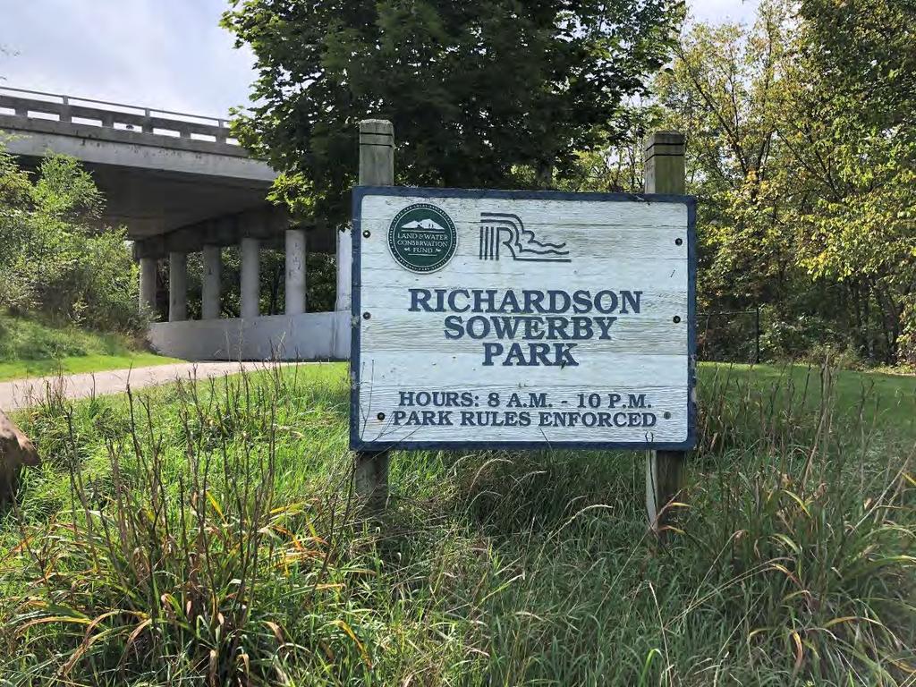
101
102 GRANT TYPE: (Please select one) Michigan Department of Natural Resources - Grants Management PUBLIC OUTDOOR RECREATION GRANT POST-COMPLETION SELF-CERTIFICATION REPORT This information required under authority of Part 19, PA 451 of 1994, as amended; the Land and Water Conservation Fund Act of 1965, 78 Stat. 897 (1964); and Part 715, of PA 451 of 1994, as amended. MICHIGAN NATURAL RESOURCES TRUST FUND CLEAN MICHIGAN INITIATIVE LAND AND WATER CONSERVATION FUND RECREATION PASSPORT BOND FUND GRANTEE: City of Rockford PROJECT NUMBER: (1992) PROJECT TYPE: Development PROJECT TITLE: Dam Island Improvements PROJECT SCOPE: Walkway and Seating on Top of Dam TO BE COMPLETED BY LOCAL GOVERNMENT AGENCY (GRANTEE) Name of Agency (Grantee) Contact Person City of Rockford Thad Beard Address 7 South Monroe Street City, State, ZIP Rockford, MI SITE DEVELOPMENT Telephone tbeard@rockfrod.mi.us Title City Manager Any change(s) in the facility type, site layout, or recreation activities provided? If yes, please describe change(s). Yes No Facilities include walkway on top of dam with benches and dam viewing that also allows fishing. Has any portion of the project site been converted to a use other than outdoor recreation? If yes, please describe what portion and describe use. (This would include cell towers and any non-recreation buildings.) Yes No Are any of the facilities obsolete? If yes, please explain. Yes No The bendches and railings have been replaced from the original installations. SITE QUALITY Is there a park entry sign which identifies the property or facility as a public recreation area? If yes, please provide a photograph of the sign. If no, please explain. Yes No Are the facilities and the site being properly maintained? If no, please explain. Yes No The facilities are maintained by the City of Rockford. Is vandalism a problem at this site? If yes, explain the measures being taken to prevent or minimize vandalism. Yes No Page 1 PR1944 (Rev. 07/07/2014)
103 POST COMPLETION SELF-CERTIFICATION REPORT - CONT D Is maintenance scheduled on a regular basis? If yes, give schedule. If no, please explain. Yes No The park receives daily and weekly maintenance throughout the summer and weekly maintenance during fall, winter, and spring. GENERAL Is a Program Recognition plaque permanently displayed at the site? If yes, please provide a photograph. (Not required for Bond Fund Grants) Yes No N/A Is any segment of the general public restricted from using the site or facilities? (i.e. resident only, league only, boaters only, etc.) If yes, please explain. Yes No Is a fee charged for use of the site or facilities? If yes, please provide fee structure. Yes No What are the hours and seasons for availability of the site? The park is open year round from 8:00 a.m. to 10:00 p.m. COMMENTS (ATTACH SEPARATE SHEET IF MORE SPACE IS NEEDED) Page 2 PR1944 (Rev. 07/07/2014)
104 POST COMPLETION SELF-CERTIFICATION REPORT - CONT'D CERTIFICATION I do hereby certify that I am duly elected, appointed and/or authorized by the Grantee named above and that the information and answers provided herein are true and accurate to the best of my personal knowledge, information and belief. Thad Beard Please print December 1, 2018 Date Christine Bedford '::.:~"!}::.~~L_J~~===~~~: December 1, 2018 Please print Date Send completed report to: POST COMPLETION GRANT INSPECTION REPORTS GRANTS MANAGEMENT MICHIGAN DEPARTMENT OF NATURAL RESOURCES PO BOX30425 LANSING Ml Page 3 PR1 944 (Rev. 07/07/2014)
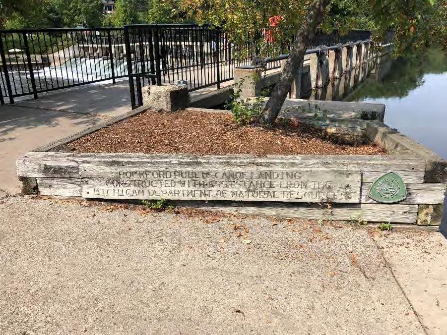
105
106 GRANT TYPE: (Please select one) Michigan Department of Natural Resources - Grants Management PUBLIC OUTDOOR RECREATION GRANT POST-COMPLETION SELF-CERTIFICATION REPORT This information required under authority of Part 19, PA 451 of 1994, as amended; the Land and Water Conservation Fund Act of 1965, 78 Stat. 897 (1964); and Part 715, of PA 451 of 1994, as amended. MICHIGAN NATURAL RESOURCES TRUST FUND CLEAN MICHIGAN INITIATIVE LAND AND WATER CONSERVATION FUND RECREATION PASSPORT BOND FUND GRANTEE: City of Rockford PROJECT NUMBER: TF (1997) PROJECT TYPE: Development PROJECT TITLE: Rogue River Overlook/Fishing PROJECT SCOPE: Improvements to East Side of Dam TO BE COMPLETED BY LOCAL GOVERNMENT AGENCY (GRANTEE) Name of Agency (Grantee) Contact Person City of Rockford Thad Beard Address 7 South Monroe Street City, State, ZIP Rockford, MI SITE DEVELOPMENT Telephone tbeard@rockfrod.mi.us Title City Manager Any change(s) in the facility type, site layout, or recreation activities provided? If yes, please describe change(s). Yes No Boardwalk, walkways, steps, fishing access to river, and picnic tables. Parking is also available on the east side of the dam at this site. A canoe portage site is as well. Has any portion of the project site been converted to a use other than outdoor recreation? If yes, please describe what portion and describe use. (This would include cell towers and any non-recreation buildings.) Yes No Are any of the facilities obsolete? If yes, please explain. Yes No SITE QUALITY Is there a park entry sign which identifies the property or facility as a public recreation area? If yes, please provide a photograph of the sign. If no, please explain. Yes No Are the facilities and the site being properly maintained? If no, please explain. Yes No The facilities are maintained by the City of Rockford. Is vandalism a problem at this site? If yes, explain the measures being taken to prevent or minimize vandalism. Yes No Page 1 PR1944 (Rev. 07/07/2014)
107 POST COMPLETION SELF-CERTIFICATION REPORT - CONT D Is maintenance scheduled on a regular basis? If yes, give schedule. If no, please explain. Yes No The park receives daily and weekly maintenance throughout the summer and weekly maintenance during fall, winter, and spring. GENERAL Is a Program Recognition plaque permanently displayed at the site? If yes, please provide a photograph. (Not required for Bond Fund Grants) Yes No N/A Is any segment of the general public restricted from using the site or facilities? (i.e. resident only, league only, boaters only, etc.) If yes, please explain. Yes No Is a fee charged for use of the site or facilities? If yes, please provide fee structure. Yes No What are the hours and seasons for availability of the site? The park is open year round from 8:00 a.m. to 10:00 p.m. COMMENTS (ATTACH SEPARATE SHEET IF MORE SPACE IS NEEDED) Page 2 PR1944 (Rev. 07/07/2014)

108 POST COMPLETION SELF-CERTIFICATION REPORT CONT'D CERTIFICATION I do hereby certify that I am duly elected, appointed and/or authorized by the Grantee named above and that the information and answers provided herein are true and accurate to the best of my personal knowledge, information and belief Thad Beard Please print Grantee Authorized Signature December 1, 2018 Date Send completed report to: POST COMPLETION GRANT INSPECTION REPORTS GRANTS MANAGEMENT MICHIGAN DEPARTMENT OF NATURAL RESOURCES PO BOX LANSING Ml Page3 PR1944 (Rev. 07/07/2014)
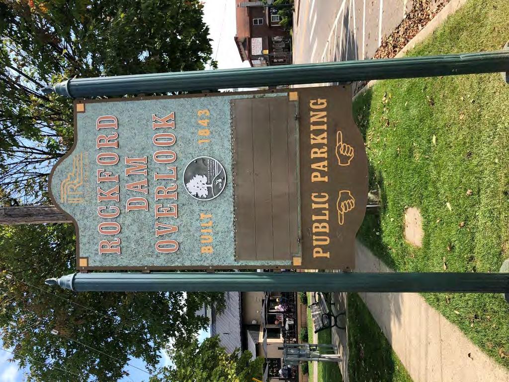
109
110 GRANT TYPE: (Please select one) Michigan Department of Natural Resources - Grants Management PUBLIC OUTDOOR RECREATION GRANT POST-COMPLETION SELF-CERTIFICATION REPORT This information required under authority of Part 19, PA 451 of 1994, as amended; the Land and Water Conservation Fund Act of 1965, 78 Stat. 897 (1964); and Part 715, of PA 451 of 1994, as amended. MICHIGAN NATURAL RESOURCES TRUST FUND CLEAN MICHIGAN INITIATIVE LAND AND WATER CONSERVATION FUND RECREATION PASSPORT BOND FUND GRANTEE: City of Rockford PROJECT NUMBER: CM (2000) PROJECT TYPE: Development PROJECT TITLE: Rum Creek Trail Development PROJECT SCOPE: Pathway, Boardwalk, Bridge, Picnic Tables, Benches, Drinking Fountain TO BE COMPLETED BY LOCAL GOVERNMENT AGENCY (GRANTEE) Name of Agency (Grantee) Contact Person City of Rockford Thad Beard Address 7 South Monroe Street City, State, ZIP Rockford, MI SITE DEVELOPMENT Telephone tbeard@rockfrod.mi.us Title City Manager Any change(s) in the facility type, site layout, or recreation activities provided? If yes, please describe change(s). Yes No Grant facilities include creekside pathway, bridge, picnic tables, benches and drinking fountain. Other site facilities include parking, restroom, and play field. Has any portion of the project site been converted to a use other than outdoor recreation? If yes, please describe what portion and describe use. (This would include cell towers and any non-recreation buildings.) Yes No Are any of the facilities obsolete? If yes, please explain. Yes No SITE QUALITY Is there a park entry sign which identifies the property or facility as a public recreation area? If yes, please provide a photograph of the sign. If no, please explain. Yes No Are the facilities and the site being properly maintained? If no, please explain. Yes No The facilities are maintained by the City of Rockford. The pathway asphalt cracks have been repaired. Is vandalism a problem at this site? If yes, explain the measures being taken to prevent or minimize vandalism. Yes No Page 1 PR1944 (Rev. 07/07/2014)
111 POST COMPLETION SELF-CERTIFICATION REPORT - CONT D Is maintenance scheduled on a regular basis? If yes, give schedule. If no, please explain. Yes No The park receives weekly maintenance throughout the summer and bi-weekly maintenance during fall, winter, and spring. GENERAL Is a Program Recognition plaque permanently displayed at the site? If yes, please provide a photograph. (Not required for Bond Fund Grants) Yes No N/A Is any segment of the general public restricted from using the site or facilities? (i.e. resident only, league only, boaters only, etc.) If yes, please explain. Yes No Is a fee charged for use of the site or facilities? If yes, please provide fee structure. Yes No What are the hours and seasons for availability of the site? The park is open year round from 8:00 a.m. to 10:00 p.m. COMMENTS (ATTACH SEPARATE SHEET IF MORE SPACE IS NEEDED) Page 2 PR1944 (Rev. 07/07/2014)

112 POST COMPLETION SELF-CERTIFICATION REPORT - CONT'D CERTIFICATION I do hereby certify that I am duly elected, appointed and/or authorized by the Grantee named above and that the information and answers provided herein are true and accurate to the best of my personal knowledge, information and belief. Thad Beard Please print Gra&ee Authorized Signature December 1, 2018 Date Send completed report to: POST COMPLETION GRANT INSPECTION REPORTS GRANTS MANAGEMENT MICHIGAN DEPARTMENT OF NATURAL RESOURCES PO BOX LANSING Ml Page 3 PR1944 (Rev. 07/07/2014)
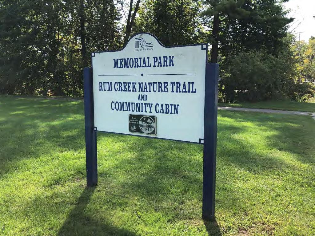
113
114 GRANT TYPE: (Please select one) Michigan Department of Natural Resources - Grants Management PUBLIC OUTDOOR RECREATION GRANT POST-COMPLETION SELF-CERTIFICATION REPORT This information required under authority of Part 19, PA 451 of 1994, as amended; the Land and Water Conservation Fund Act of 1965, 78 Stat. 897 (1964); and Part 715, of PA 451 of 1994, as amended. MICHIGAN NATURAL RESOURCES TRUST FUND CLEAN MICHIGAN INITIATIVE LAND AND WATER CONSERVATION FUND RECREATION PASSPORT BOND FUND GRANTEE: City of Rockford PROJECT NUMBER: TF (2003) PROJECT TYPE: Development PROJECT TITLE: Rogue River Trail Network PROJECT SCOPE: Pathway and Fishing Docks TO BE COMPLETED BY LOCAL GOVERNMENT AGENCY (GRANTEE) Name of Agency (Grantee) Contact Person City of Rockford Thad Beard Address 7 South Monroe Street City, State, ZIP Rockford, MI SITE DEVELOPMENT Telephone tbeard@rockfrod.mi.us Title City Manager Any change(s) in the facility type, site layout, or recreation activities provided? If yes, please describe change(s). Yes No Grant facilities include riverfront pathway, fishing docks, and benches. Other facilities include a dog park and connections to the Rogue River Nature Trail. Has any portion of the project site been converted to a use other than outdoor recreation? If yes, please describe what portion and describe use. (This would include cell towers and any non-recreation buildings.) Yes No Are any of the facilities obsolete? If yes, please explain. Yes No SITE QUALITY Is there a park entry sign which identifies the property or facility as a public recreation area? If yes, please provide a photograph of the sign. If no, please explain. Yes No Are the facilities and the site being properly maintained? If no, please explain. Yes No The facilities are maintained by the City of Rockford. Is vandalism a problem at this site? If yes, explain the measures being taken to prevent or minimize vandalism. Yes No Page 1 PR1944 (Rev. 07/07/2014)
115 POST COMPLETION SELF-CERTIFICATION REPORT - CONT D Is maintenance scheduled on a regular basis? If yes, give schedule. If no, please explain. Yes No The park receives weekly maintenance throughout the summer and weekly maintenance during fall, winter, and spring. GENERAL Is a Program Recognition plaque permanently displayed at the site? If yes, please provide a photograph. (Not required for Bond Fund Grants) Yes No N/A Is any segment of the general public restricted from using the site or facilities? (i.e. resident only, league only, boaters only, etc.) If yes, please explain. Yes No Is a fee charged for use of the site or facilities? If yes, please provide fee structure. Yes No What are the hours and seasons for availability of the site? The park is open year round from 8:00 a.m. to 10:00 p.m. COMMENTS (ATTACH SEPARATE SHEET IF MORE SPACE IS NEEDED) Page 2 PR1944 (Rev. 07/07/2014)
116 POST COMPLETION SELF-CERTIFICATION REPORT - CONT'D CERTIFICATION I do hereby certify that I am duly elected, appointed and/or authorized by the Grantee named above and that the information and answers provided herein are true and accurate to the best of my personal knowledge, information and belief. _Th_ad_ B_ea_r_d _ ~~ Please print Grantee Authorized Signature December 1, 2018 Date Send completed report to: POST COMPLETION GRANT INSPECTION REPORTS GRANTS MANAGEMENT MICHIGAN DEPARTMENT OF NATURAL RESOURCES PO BOX LANSING Ml Page 3 PR1 944 (Rev. 07/07/2014)
117
118 GRANT TYPE: (Please select one) Michigan Department of Natural Resources - Grants Management PUBLIC OUTDOOR RECREATION GRANT POST-COMPLETION SELF-CERTIFICATION REPORT This information required under authority of Part 19, PA 451 of 1994, as amended; the Land and Water Conservation Fund Act of 1965, 78 Stat. 897 (1964); and Part 715, of PA 451 of 1994, as amended. MICHIGAN NATURAL RESOURCES TRUST FUND CLEAN MICHIGAN INITIATIVE LAND AND WATER CONSERVATION FUND RECREATION PASSPORT BOND FUND GRANTEE: City of Rockford PROJECT NUMBER: TF (2006) PROJECT TYPE: Development PROJECT TITLE: Rogue River Trail Network Extension PROJECT SCOPE: Boardwalk Pathway and Fishing TO BE COMPLETED BY LOCAL GOVERNMENT AGENCY (GRANTEE) Name of Agency (Grantee) Contact Person City of Rockford Thad Beard Address 7 South Monroe Street City, State, ZIP Rockford, MI SITE DEVELOPMENT Telephone tbeard@rockfrod.mi.us Title City Manager Any change(s) in the facility type, site layout, or recreation activities provided? If yes, please describe change(s). Yes No Facilities include a riverfront pathway with boardwalk and fishing platforms. Has any portion of the project site been converted to a use other than outdoor recreation? If yes, please describe what portion and describe use. (This would include cell towers and any non-recreation buildings.) Yes No Are any of the facilities obsolete? If yes, please explain. Yes No SITE QUALITY Is there a park entry sign which identifies the property or facility as a public recreation area? If yes, please provide a photograph of the sign. If no, please explain. Yes No Are the facilities and the site being properly maintained? If no, please explain. Yes No The facilities are maintained by the City of Rockford. Is vandalism a problem at this site? If yes, explain the measures being taken to prevent or minimize vandalism. Yes No Page 1 PR1944 (Rev. 07/07/2014)
119 POST COMPLETION SELF-CERTIFICATION REPORT - CONT D Is maintenance scheduled on a regular basis? If yes, give schedule. If no, please explain. Yes No The park receives daily weekly maintenance throughout the summer and weekly maintenance during fall, winter, and spring. GENERAL Is a Program Recognition plaque permanently displayed at the site? If yes, please provide a photograph. (Not required for Bond Fund Grants) Yes No N/A Is any segment of the general public restricted from using the site or facilities? (i.e. resident only, league only, boaters only, etc.) If yes, please explain. Yes No Is a fee charged for use of the site or facilities? If yes, please provide fee structure. Yes No What are the hours and seasons for availability of the site? The park is open year round from 8:00 a.m. to 10:00 p.m. COMMENTS (ATTACH SEPARATE SHEET IF MORE SPACE IS NEEDED) Page 2 PR1944 (Rev. 07/07/2014)
120 POST COMPLETION SELF-CERTIFICATION REPORT - CONT'D CERTIFICATION I do hereby certify that I am duly elected, appointed and/or authorized by the Grantee named above and that the information and answers provided herein are true and accurate to the best of my personal knowledge, information and belief Thad Beard Please print Grantee Authorized Signature December 1, 2018 Date Christine Bedford Please print December 1, 2018 Date Send completed report to: POST COMPLETION GRANT INSPECTION REPORTS GRANTS MANAGEMENT MICHIGAN DEPARTMENT OF NATURAL RESOURCES PO BOX LANSING Ml Page 3 PR1944 (Rev. 07/07/2014)
121
122 GRANT TYPE: (Please select one) Michigan Department of Natural Resources - Grants Management PUBLIC OUTDOOR RECREATION GRANT POST-COMPLETION SELF-CERTIFICATION REPORT This information required under authority of Part 19, PA 451 of 1994, as amended; the Land and Water Conservation Fund Act of 1965, 78 Stat. 897 (1964); and Part 715, of PA 451 of 1994, as amended. MICHIGAN NATURAL RESOURCES TRUST FUND CLEAN MICHIGAN INITIATIVE LAND AND WATER CONSERVATION FUND RECREATION PASSPORT BOND FUND GRANTEE: City of Rockford PROJECT NUMBER: TF PROJECT TYPE: Development PROJECT TITLE: Rogue River Nature Trail and Boardwalk Development PROJECT SCOPE: Continuation of nature trail and boardwalk TO BE COMPLETED BY LOCAL GOVERNMENT AGENCY (GRANTEE) Name of Agency (Grantee) Contact Person City of Rockford Thad Beard Address 7 South Monroe Street City, State, ZIP Rockford, MI SITE DEVELOPMENT Telephone tbeard@rockfrod.mi.us Title City Manager Any change(s) in the facility type, site layout, or recreation activities provided? If yes, please describe change(s). Yes No Facilities include riverside trail and boardwalk with benches. Has any portion of the project site been converted to a use other than outdoor recreation? If yes, please describe what portion and describe use. (This would include cell towers and any non-recreation buildings.) Yes No Are any of the facilities obsolete? If yes, please explain. Yes No SITE QUALITY Is there a park entry sign which identifies the property or facility as a public recreation area? If yes, please provide a photograph of the sign. If no, please explain. Yes No Are the facilities and the site being properly maintained? If no, please explain. Yes No The facilities are maintained by the City of Rockford. Is vandalism a problem at this site? If yes, explain the measures being taken to prevent or minimize vandalism. Yes No Page 1 PR1944 (Rev. 07/07/2014)
123 POST COMPLETION SELF-CERTIFICATION REPORT - CONT D Is maintenance scheduled on a regular basis? If yes, give schedule. If no, please explain. Yes No The park receives daily weekly maintenance throughout the summer and weekly maintenance during fall, winter, and spring. GENERAL Is a Program Recognition plaque permanently displayed at the site? If yes, please provide a photograph. (Not required for Bond Fund Grants) Yes No N/A Is any segment of the general public restricted from using the site or facilities? (i.e. resident only, league only, boaters only, etc.) If yes, please explain. Yes No Is a fee charged for use of the site or facilities? If yes, please provide fee structure. Yes No What are the hours and seasons for availability of the site? The park is open year round from 8:00 a.m. to 10:00 p.m. COMMENTS (ATTACH SEPARATE SHEET IF MORE SPACE IS NEEDED) Page 2 PR1944 (Rev. 07/07/2014)
124 POST COMPLETION SELF-CERTIFICATION REPORT CONT'D CERTIFICATION I do hereby certify that I am duly elected, appointed and/or authorized by the Grantee named above and that the information and answers provided herein are true and accurate to the best of my personal knowledge, information and belief. Thad Beard ~~ Please print Grantee Authorized Signature December 1, 2018 Date Christine Bedford Please print December 1, 2018 Date Send completed report to: POST COMPLETION GRANT INSPECTION REPORTS GRANTS MANAGEMENT MICHIGAN DEPARTMENT OF NATURAL RESOURCES PO BOX LANSING Ml Page3 PR1944 (Rev /2014)
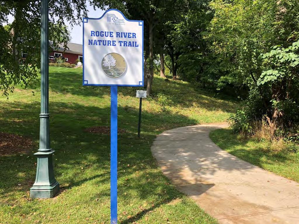
125
126 Appendix B Rockford Parks and Recreation Public Survey Results 2019 Draft Community Recreation Plan City of Rockford 80

127 CITY OF ROCKFORD PARKS AND RECREATION SURVEY DECEMBER 1, 2018 Survey Prepared By: P.M. Blough, Inc.
City of Haslett. City of East Lansing. City of East Lansing
 Central Park North (Nancy L. Moore Park) Lake Park North Expansion White Park Expansion #2 White Park Expansion #1 County East East Haslett East East TF87-212 Acquisition $90,000.00 Park. TF08-138 Acquisition
Chapter 6. Action Program. Heart of the Lakes Area Recreation Plan
 Heart of the Lakes Area Recreation Plan 1. Design and construct the following trails (please see the following map): a. the Speedway Trail 1) primary pathway the main trail 2) secondary pathway the proposed
2. Goals and Policies. The following are the adopted Parks and Trails Goals for Stillwater Township:
 D. PARKS AND TRAILS 1. Introduction Stillwater Township s population is relatively low, with most residents living on rural residences on large lots. The need for active park space has been minimal in
J. Recreation Plan of Conservation and Development. The Town of Hebron. Section 2. Preservation of Unique Assets. 1 P a g e
 The Town of Hebron Section 2 2014 Plan of Conservation and Development Preservation of Unique Assets J. Recreation Open spaces, parks, sports fields, and recreational programs are considered essential
Chapter eight. Parks and Recreation. Introduction. Crystal Lake Park District
 Chapter eight Parks and Recreation Introduction One of the indicators of quality of life in a city is the parks and recreation system. The City of Crystal Lake is fortunate to have an excellent parks and
Public Park System. Township of Derry. Providing natural open space for the recreational use of our residents and guests.
 Township of Derry Public Park System Providing natural open space for the recreational use of our residents and guests. Directory of Recreational Amenities Hershey s Commitment to Recreation Famous candy
Acquisition in fee simple of approximately one-half acre of property on the shore of Spring Lake to expand the Lakeside Beach Park.
 Lakeside Beach TF00-136 $122,550.00 in fee simple of approximately one-half acre of property on the shore of Spring Lake to exp the Lakeside Beach. 2000 River Ravines TF00-150 $910,000.00 in fee simple
PIONEER PARK. City of Des Peres Parks Master Plan. SWT Design 46 INTRODUCTION
 PIONEER PARK INTRODUCTION Pioneer Park is a 7 acre neighborhood park located east of Interstate 270 and south of Manchester Road along Tallie Road. The park is situated in a residential neighborhood with
Dover Park Master Plan. Community Design Event Tuesday, May 22, 5 7 pm
 Dover Park Master Plan Community Design Event Tuesday, May 22, 5 7 pm Agenda I. Introduction / Overview 20 minutes II. Small Group Design Activity 60 minutes III. Small Group Report Out IV. Conclusion
APPENDIX E: SUMMARY OF PUBLIC MEETING QUESTIONNAIRE RESULTS
 Appendices Gwinnett County 2004 Comprehensive Parks and Recreation Master Plan APPENDIX E: SUMMARY OF PUBLIC MEETING QUESTIONNAIRE RESULTS March 2004 Monteith Brown Planning Consultants & The Jaeger Company
Schoolcraft Township is located in northeast Houghton County. A portion of the township borders Keweenaw County and Lake Superior.
 COMMUNITY DESCRIPTION Schoolcraft Township is located in northeast Houghton County. A portion of the township borders Keweenaw County and Lake Superior. The township is largely rural but has one main population
Hampton Township. Community Description
 Hampton Township Community Description Hampton Township is located in southern Bay County, east of Bay City and Essexville. It contains approximately 9 miles of Saginaw Bay shoreline and 1.5 miles of Saginaw
MINUTES FILED WITH TOWN CLERK
 Page 1 of 7 Town of Farmington Parks Master Plan Advisory Committee FILED WITH TOWN CLERK January 28, 2015 TOWN OF FARMINGTON PARKS MASTER PLAN ADVISORY COMMITTEE MINUTES OF THE MEETING OF JANUARY 28,
CHAPTER 5. Chapter 5 Recreation Element
 CHAPTER 5 Recreation Element Chapter 5 Recreation Element The Recreation Element of the Meyers Area Plan is a supplement to the Recreation Element of the TRPA Regional Plan and the El Dorado County General
Northeast Quadrant Distinctive Features
 NORTHEAST QUADRANT Northeast Quadrant Distinctive Features LAND USE The Northeast Quadrant includes all the area within the planning area that is east of Interstate 5 and to the north of State Route 44.
4MRV Parks Master Plan: Site Analysis
 4MRV Parks Master Plan: Site Analysis Lardner/Klein Landscape Architects in association with: RK&K Grimm + Parker Kittelson & Associates Partners for Economic Solutions RIB U.S.Cost Civil Engineering Architecture
Chapter 2: Summary of Existing Open Space System
 Chapter 2: Summary of Existing Open Space System In 1976, the Wake County Board of Commissioners established the Wake County Parks and Recreation Department in order to provide park facilities and programs
Section 5.16 Parks and Recreation Facilities
 Section 5.16 Parks and Recreation Facilities SECTION 5.16 PARKS AND RECREATION FACILITIES This section identifies existing parks and recreational facilities within the City of Buena Park and provides an
Cascade River State Park Management Plan Amendment
 This document is made available electronically by the Minnesota Legislative Reference Library as part of an ongoing digital archiving project. http://www.leg.state.mn.us/lrl/lrl.asp Cascade River State
FY20 BUDGET PRESENTATION
 FY20 BUDGET PRESENTATION Mission Statement: To provide for diverse recreational opportunities and amenities that enhance the quality of life for our residents and visitors to the City of Frederick through
CHAPTER 4 EXISTING PARKS AND RECREATION FACILITIES INVENTORY
 CHAPTER 4 EXISTING PARKS AND RECREATION FACILITIES INVENTORY Existing park and recreation sites and facilities provide the basis upon which to build a park and recreation plan for the city. This inventory
Stambaugh Township 5-Year Recreation Plan - DRAFT
 Stambaugh Township 5-Year Recreation Plan - DRAFT Stambaugh Township GEI Project No. 1702677 January 5, 2018 Table of Contents 1. Community Description 1 2. Administrative Structure 2 3. Recreation Inventory
Southwest Quadrant Distinctive Features
 SOUTHWEST QUADRANT Southwest Quadrant Distinctive Features LAND USE The 31.17 square mile Southwest Quadrant includes all the area within the planning area west of I-5 and south of the Sacramento River.
Classes Other locations & Parks
 Other Parks 1 Classes Other locations & Parks Update: 6/11/2018 Visit us online at www.coconutcreek.net/parks-rec How to register for a class Registration is ongoing until filled, except in cases where
METROPOLITAN COUNCIL 390 North Robert Street, St. Paul, MN Phone (651) TDD (651)
 TDD (651)") DATE: March 27, 2012 METROPOLITAN COUNCIL 390 North Robert Street, St. Paul, MN 55101 Phone (651) 602-1000 TDD (651) 291-0904 TO: Metropolitan Parks and Open Space Commission FROM: Arne Stefferud, Planning
DATE: March 27, 2012 METROPOLITAN COUNCIL 390 North Robert Street, St. Paul, MN 55101 Phone (651) 602-1000 TDD (651) 291-0904 TO: Metropolitan Parks and Open Space Commission FROM: Arne Stefferud, Planning
NORTHWEST SECTION CONTENTS: CLEVELAND PARK FOLWELL PARK RYAN LAKE PARK VICTORY PRAIRIE DOG PARK VICTORY PARK
 NORTHWEST SECTION CONTENTS: CLEVELAND PARK FOLWELL PARK RYAN LAKE PARK VICTORY PRAIRIE DOG PARK VICTORY PARK LUCY LANEY COMMUNITY SCHOOL N 33RD AVE N 33RD AVE SINGLE-FAMILY RESIDENTIAL MULTI-USE DIAMOND
4.0 Context for the Crossing Project
 4.0 Context for the Crossing Project This section provides background information about key features of the North Douglas Crossing project area, and opportunities and constraints. This information is important
City of Keller Parks and Facilities Inventory
 City of Keller Parks and Facilities Inventory April 2013 1. BEAR CREEK PARK 44 ACRES 1 Basketball Court with 2 goals 4 Drinking Fountains 1 Large Pavilion with 4 picnic tables, electricity and fireplace
Lake Myra County Park. Wake County, North Carolina Community Forum #2 June 12, 2008
 Lake Myra County Park Wake County, North Carolina Community Forum #2 June 12, 2008 Welcome and Introduction Meeting Agenda Welcome Introductions of Project Team Master Plan Process Community Forum #1 Updates
Silver Lake Park An Environmental Jewel for the Citizens of Prince William County
 Silver Lake Park An Environmental Jewel for the Citizens of Prince William County The Prince William Park Authority Mission Statement states: The Prince William County Park Authority will create quality
Park Design and Location Criteria
 Park Design and Location Criteria This section is presented in the interest of assisting park and recreation agencies in the development of a system of parks and recreation areas. A recreation system is
Rogue River Access and Management Plan Draft Alternatives
 Rogue River Access and Management Plan Draft Alternatives The Rogue River Access and Management Plan was initiated in December, 2011 and is being led by Jackson County Parks (JCP) and Oregon Department
Blueways: Rivers, lakes, or streams with public access for recreation that includes fishing, nature observation, and opportunities for boating.
 Parks, Open Space and Trails PRINCE WILLIAM COUNTY 2008 COMPREHENSIVE PLAN TRAILS PLAN CONTENTS The components of the trails plan are: Intent Definitions Goals, Policies, and Action Strategies Trails Map
The City of Durango Community Interest and Opinion Survey Executive Summary
 The City of Durango Community Interest and Opinion Survey Executive Summary Overview ETC Institute administered a community interest and opinion survey for the City of Durango between January and March
Business Item No XXX. Proposed Action That the Metropolitan Council approve the Coon Creek Regional Trail Master Plan.
 Business Item No. 2015-XXX Metropolitan Parks and Open Space Commission Meeting date: July 7, 2015 For the Community Development Committee meeting of July 20, 2015 For the Metropolitan Council meeting
MASTER PLAN EXECUTIVE SUMMARY
 Biscuit Run State Park Scottsville Road (State Route 20) Charlottesville, VA 22902 Biscuit Run State Park MASTER PLAN EXECUTIVE SUMMARY Department of Conservation and Recreation Division of Planning and
Committee Report. Community Development Committee For the Metropolitan Council meeting of August 12, Business Item No.
 Committee Report Business Item No. 2015-168 Community Development Committee For the Metropolitan Council meeting of August 12, 2015 Subject: Coon Creek Regional Trail Master Plan, Anoka County Proposed
Rating: 5.0 (scale of 1-10)
") 95 Community Trail System Groundcover: 2-metre paved path, 1- metre grass buffer on either side. Location: Fort St. John Ownership: City of Fort St. John Rating: 5.0 (scale of 1-10) Strategic value: Linear
95 Community Trail System Groundcover: 2-metre paved path, 1- metre grass buffer on either side. Location: Fort St. John Ownership: City of Fort St. John Rating: 5.0 (scale of 1-10) Strategic value: Linear
Section II. Planning & Public Process Planning for the Baker/Carver Regional Trail began in 2010 as a City of Minnetrista initiative.
 Section II Planning & Public Process Planning for the began in 2010 as a City of initiative. city staff began discussions with the Park District on the possibility of a north/south regional trail connection
Parks, Recreation and Cultural Needs Assessment and Facilities Plan. November 21, 2016 City Council Worksession
 Parks, Recreation and Cultural Needs Assessment and Facilities Plan November 21, 2016 City Council Worksession History and Process FY16/17 Budget Appropriation for Needs Assessment, Dean and Stonewall
4.0 FACILITIES INVENTORY
 4.0 FACILITIES INVENTORY 4.1 PARK LEVEL OF SERVICE STANDARDS (LOS) Based on current City of Longview Parks and Recreation Level of Service (LOS) Standards (Figure G), the City currently has a deficiency
Community Advisory Committee Meeting #3 April 21, 2015
 Community Advisory Committee Meeting #3 April 21, 2015 Purpose (charge) of the CAC: Be Knowledgeable, Be an Engaged Representative, Develop Master Plan, & Prioritize Plan 1 Welcome/ Introductions Review
2014 STATEWIDE COMPREHENSIVE OUTDOOR RECREATION PLAN
 2014 STATEWIDE COMPREHENSIVE OUTDOOR RECREATION PLAN SUSTAINING COLORADO S OUTDOOR RECREATION FUTURE SECTION 1: INTRODUCTORY INFORMATION WHAT IS THE SCORP? The SCORP update is required every five years
WEST JORDAN PARKS, RECREATION AND TRAILS MASTER PLAN Advisory Committee Meeting #2
 WEST JORDAN PARKS, RECREATION AND TRAILS MASTER PLAN Advisory Committee Meeting #2 MONDAY, NOVEMBER 5, 2018, 6:00 P.M.; PARKS DEPT. CONFERENCE ROOM ATTENDEES: Lisa Dean Larry Gardner Duane Harding David
AGENDA REGULAR PARKS COMMISSION MEETING May 26, :15 A.M Monticello Public Works Office
 Park Commission Agenda: 05/26/2016 AGENDA REGULAR PARKS COMMISSION MEETING May 26, 2016 9:15 A.M Monticello Public Works Office To enhance community pride through developing and maintaining city parks
Logo Department Name Agency Organization Organization Address Information 5700 North Sabino Canyon Road
 Logo Department Name Agency Organization Organization Address Information United States Forest Coronado National Forest 5700 North Sabino Canyon Road Department of Service Santa Catalina Ranger District
Picture your next event in Novi!
 Picture your next event in Novi! Facility Reservation Guide Why Novi? Thank you for considering Novi as the location for your next event. We look forward to welcoming you at one of our unique venues which
Trail Etiquette. Hours of Operation. Trail Accessibility
 Trail Guide The Elmhurst Park District, with 28 parks and over 460 acres of land, offers nearly six miles of paved or asphalt park trails and maintains an additional 3.6 miles of trails within Elmhurst.
F. Forest Recreation Management
 F. Forest Recreation Management F.1) Park and Recreation Management F.1.A. Program Overview. The park and recreation program has been in existence since 1980. With ever increasing outdoor recreation demands
China Creek North Park Upgrades and Glen Pump Station. Park Board Committee Meeting Monday, July 10, 2017
 China Creek North Park Upgrades and Glen Pump Station Park Board Committee Meeting Monday, July 10, 2017 Purpose The purpose of this presentation is to: Share the results of the public engagement processes;
CITY OF FOUNTAIN INN PARKS
 CITY OF FOUNTAIN INN PARKS Country Chase Fitness Park The Country Chase Fitness Park is located in the Country Chase neighborhood at 136 Catterick Way. The park is also located adjacent to a section of
Chapter 9 Recreation
 Chapter 9 Chapter 9 1.0 INTRODUCTION The Town of Littleton is within one of New England s most important recreation areas. More than three million people live within 100 miles of the area. Local residents
City of Chelan Shoreline Public Access Plan
 City of Shoreline Public Access Plan This City of Shoreline Public Access Plan documents how the City has planned for parks and recreation in the community, particularly along Lake and the River. This
Executive Summary Downtown Park Fund Allocation HEARING DATE: MAY 5, 2016
 Executive Summary Downtown Park Fund Allocation HEARING DATE: MAY 5, 2016 Date: April 28, 2016 Case No.: 2016 004634CWP Project Name: Allocation of $4,000,000 from the Downtown Park Fund for the Renovation
City of Galion Park Satisfaction Survey Results
 City of Galion Park Satisfaction Survey Results Dec. 5, 2016 Goal: To get feedback from the community on: 1. General satisfaction of city-owned parks 2. How to improve park facilities and recreation opportunities
Yuba Creek Natural Area Acquisition. Acme Township. Acme Township. TF Acquisition $1,576, Grand Traverse
 Yuba Creek Natural Area TF00-162 $1,576,021.00 in fee simple of 403 acres of critical wetls upl habitat with over 5,000 feet of frontage on Yuba Creek, a tributary to the east arm of Bay. 2000 Petobago
10/25/2013. What is the SCORP?! 2013 Local Government Survey 2013 Statewide Public Survey Advisory Group Priority Areas Your Suggestions!
 COLORADO OUTDOOR RECREATION TRENDS RESULTS FROM THE SCORP AND STATEWIDE Colorado Outdoor Recreation Resource Partnership September 2013 PRESENTATION What is the SCORP?! 2013 Local Government Survey 2013
IL 390 Station. Wood Dale Open House Summary 5/18/17
 Wood Dale Open House Summary 5/18/17 The first public open house for the Wood Dale Comprehensive Plan took place on May 18 th, 2017. The program was conducted as a fun community event and there were 216
and plant some trees, but that was only accomplished through state and federal work-relief programs.
 PEAVEY LOCATION AND HISTORY Peavey Park sits in the Phillips Community on a large block bounded by major streets: Franklin Avenue, Chicago Avenue, and Park Avenue. The southern continue through to Chicago
Township Superintendent
 EMPLOYMENT OPPORTUNITY Township Superintendent Buena Vista Charter Township Township Superintendent BUENA VISTA CHARTER TOWNSHIP Buena Vista Charter Township, located in Saginaw County, Michigan, strives
City of Durango 5.8 FUNDING TRAILS DEVELOPMENT
 5.8 FUNDING TRAILS DEVELOPMENT The City has been successful in establishing dedicated local funding sources as well as applying for grants to develop the City s trail system, having received nearly $2.4
Parks, Recreation, Trails and Open Space Master Plan Survey Results. October 2018
 Parks, Recreation, Trails and Open Space Master Plan Survey Results October 2018 Conducted by Qualtrics subconsultant 300 completed responses Random attempt to get a balanced response from all four Council
MEDIUM SIZE STADIUM STRATEGY
 MEDIUM SIZE STADIUM STRATEGY Approved by City Council on March 12, 2014 This plan is available online at www.edmonton.ca I. Executive Summary... 4 II. Medium Size Stadium Strategy... 5 1. Background...
CHAPTER 3 PLANNING GOALS
 CHAPTER 3 PLANNING GOALS AND PUBLIC INPUT INTRODUCTION This portion of the Algonac Master Plan is intended to outline a course for action in achieving the community s vision for the future. Throughout
NORTH OF BROADWAY SECTION CONTENTS: COTTAGE PARK FARVIEW PARK GLEN GALE PARK IRVING TRIANGLE JORDAN PARK NEWTON PARK PERKINS HILL PARK
 NORTH OF BROADWAY SECTION CONTENTS: COTTAGE PARK FARVIEW PARK GLEN GALE PARK IRVING TRIANGLE JORDAN PARK NEWTON PARK PERKINS HILL PARK N ILIO NA VE N JAM ES AV E PLAYGROUND PAR K PRO PER TY B OUN DAR Y
Webber Park Master Plan Charrette Summary
 SMALL GROUP #1 - September 29, 2011 Webber Park Master Plan Charrette Summary More trash cans, especially near picnic grounds A year round pool is very needed-physical & mental health are significantly
EMPLOYMENT OPPORTUNITY. Police Chief. Buena Vista Charter Township
 EMPLOYMENT OPPORTUNITY Police Chief Buena Vista Charter Township Police Chief BUENA VISTA CHARTER TOWNSHIP Buena Vista Charter Township is located in Saginaw County, Michigan. The township strives to be
Frederickson LUAC. Community Plan Update. Parks & Recreation. September 25, 2017
 Frederickson LUAC Community Plan Update Parks & Recreation September 25, 2017 Kimberly Freeman Resource Stewardship Superintendent kimberly.freeman@co.pierce.wa.us 253-798-4261 Joseph Coppo Senior Parks
Town of Castle Rock Parks and Recreation 1
 Town of Castle Rock Parks and Recreation 1 The 2018-2020 Strategic Plan will focus on the following items: Neighborhood park planning is the focus of this presentation. Other strategic plan priorities
Georgetown-Lewes Rail/Trail Study. Rail/Trail Study: Cool Spring to Cape Henlopen State Park New Road Extension (House Resolution No.
 Georgetown-Lewes Rail/Trail Study Rail/Trail Study: Cool Spring to Cape Henlopen State Park New Road Extension (House Resolution No. 47) August 22, 2011 Presentation Outline Background Benefits Statewide
PARKS & AMENITIES. Presented by Brad Swanson, Public Works Director Duane Rader, Parks Superintendent
 PARKS & AMENITIES Presented by Brad Swanson, Public Works Director Duane Rader, Parks Superintendent City of North Mankato Incorporated in 1898 Past Tanley Baseball Field 1930s Tanley Baseball Field was
The Master Plan, Walkability, and Trails in the City of Solon. April 23, 2018
 The Master Plan, Walkability, and Trails in the City of Solon April 23, 2018 Tonight s topics 1. Existing trail options in the City of Solon 2. Potential trail options 3. How trails and walkability converge
PARKS AND RECREATION ACTIVITIES GUIDE
 PARKS AND RECREATION ACTIVITIES GUIDE SPRING/SUMMER 2018 http://www.fayetteville-ar.gov/parks Table of Contents Table of Contents 1. Trails 2. s 3. Adult Sports 4. Youth Sports 5. Be Active! Summer Camps
Welcome to the future of Terwillegar Park a Unique Natural Park
 Welcome to the future of Terwillegar Park a Unique Natural Park 1 Introduction The Terwillegar Park Concept Plan study will develop an overall concept plan, management objectives and development guidelines
Appendix B - Undeveloped Parks and Existing Parks with Remaining Development Programming
 Appendix B - Undeveloped Parks and Existing Parks with Remaining Development Programming Table of Contents Appendix B - Undeveloped Parks and Existing Parks with Remaining Development Programming Table
NEW MEADOWS PARK PROPOSED MASTER PLAN
 NEW MEADOWS PARK PROPOSED MASTER PLAN A vision for your neighborhood park, the draft master plan is ready for your review. Tuesday September 12 th, 2017 5:30-7:00 PM Hellgate School District #4 middle
Village of Bellaire. Recreation Plan
 Village of Bellaire Recreation Plan 2013 2017 TABLE OF CONTENTS Page # Community Description... 2 Administrative Structure... 3-4 Recreation Inventory... 5 Craven Park... 6 Holiday Acres... 7 Ohio Street
Business Item No
 Metropolitan Parks and Open Space Commission Meeting date: February 6, 2018 For the Community Development Committee meeting of February 20, 2018 For the Metropolitan Council meeting of February 28, 2018
BRYAN REGIONAL PARK. Presented by: Burditt Consultants November 13, 2018
 BRYAN REGIONAL PARK Presented by: Burditt Consultants November 13, 2018 AGENDA 1. Project Purpose & Mission 2. Project Vision & Goals 3. Stakeholder Feedback 4. Program Overview 5. Phase A Plan Overview
Stony Creek Master Plan Public Meeting #2. May 21, 2016
 Stony Creek Master Plan Public Meeting #2 May 21, 2016 Today s Agenda 10:00 10:20 am Presentation 10:20 10:45 am Q & A 10:45 11:30 am Browse, discuss, and comment Metroparks Master Plan Process 4 months
M. Spina, Councillor J. Cowden, School District No. 73 N. DeCicco, Projects and Planning Supervisor, City of Kamloops
 MINUTES OF A MEETING OF THE KAMLOOPS PARKS AND RECREATION COMMITTEE HELD ON WEDNESDAY, NOVEMBER 26, 2014, AT 7:00 AM IN THE TOURNAMENT CAPITAL CENTRE, MEETING ROOM "D" RECOMMENDATION: That Council authorize
Recreation and Park Commission, Capital Committee
 DATE: March 7, 2018 TO: THRU: FROM: RE: Recreation and Park Commission, Capital Committee Philip A. Ginsburg, General Manager Lisa Bransten, Director of Partnerships New Park at Francisco Reservoir Park
Procedure for the Use of Power-Driven Mobility Devices on Mass Audubon Sanctuaries 1 September 17, 2012
 Procedure for the Use of Power-Driven Mobility Devices on Mass Audubon Sanctuaries 1 September 17, 2012 Background As part of Mass Audubon s mission to preserve the nature of Massachusetts for people and
Municipal Park Descriptions: 1. Bear Hollow Park 4100 Bear Hollow Park Court, Murrysville, PA acres
 MUNICIPAL PARK DESCRIPTIONS Murrysville has a wide variety of parks and recreational facilities including sports fields, neighborhood parks, community parks, a Community Center, and extensive natural areas
Non-Motorized Transportation
 Non-Motorized Transportation Non-motorized facilities are important components to the transportation system. They provide an environmentally-friendly, low-cost mode of travel. Some of the facilities can
Nelson/Tasman Recreation Cross Boundary Partnerships. Presented by Richard Kempthorne Mayor Tasman District
 Nelson/Tasman Recreation Cross Boundary Partnerships Presented by Richard Kempthorne Mayor Tasman District Presentation in two parts Regional Communities Facilities Plan Regional Communities Facilities
City of LA Valley Glen - North Sherman Oaks STUDY AREA PROFILE
 City of LA Valley Glen - North Sherman Oaks STUDY AREA PROFILE STUDY AREA ID #61 BASE MAP PARK METRICS WHERE ARE PARKS MOST NEEDED AMENITY QUANTITIES AND CONDITIONS PARK NEEDS FRAMEWORK PROJECT COST ESTIMATES
CLEVELAND PARK LOCATION AND HISTORY EXISTING CONDITIONS AND CHARACTER LOCATION
 CLEVELAND PARK LOCATION LOCATION AND HISTORY Attempts to create a neighborhood park and playground in the Cleveland neighborhood began in 1926, when the park board designated for acquisition the block
City of Somersworth. Recreation Division
 City of Somersworth Recreation Division 2018 Park Inventory Table of Contents I. Ash Street Park..1-3 II. Jules Bisson Park..6-10 III. Malley Farm Recreational Area.11-12 IV. Mast Point Dam Recreation
YOU CAN MAKE A DIFFERENCE! VISIONING SESSION FOR THREAD LAKE OCTOBER 8, 2013
 YOU CAN MAKE A DIFFERENCE! VISIONING SESSION FOR THREAD LAKE OCTOBER 8, 2013 PEOPLE IN NEIGHBORHOODS & INSTITUTIONS ARE BUILDING A BETTER FLINT RIGHT NOW! DIPLOMAT PHARMACY GENESSEE COUNTY LAND BANK FLINT
ADVENTURE PLAN EXPLORE PARK
 ADVENTURE PLAN ROANOKE COUNTY S EXPLORE PARK ROANOKE COUNTY PARKS, RECREATION AND TOURISM 1206 KESSLER MILL RD SALEM, VA 24153 (540) 387-6078 WHAT S INCLUDED? Explore Park Adventure Plan - Guided by extensive
M E S T I Z O C U R T I S P A R K
 ARAPAHOE CONNECTION TO BUS ROUTE AT ND AND LAWRENCE, FUTURE LIGHT RAIL STATION LEGEND SOCIAL TRAIL FLAGSTONE PAVING TO RESTORE/MAINTAIN CONCRETE PAVING DIAGONAL CURVILINEAR SOCIAL ROUTE IS OUT OF HISTORIC
20 Grant s Trail. Planning Zone 3. Visit Date: September St. Louis County Parks Master Plan
 20 Grant s Trail Planning Zone 3 Visit Date: September 2016 Page 1 20 Grant s Trail Planning Zone 3 Visit Date: September 2016 Page 2 20 Grant s Trail Planning Zone 3 Visit Date: September 2016 Page 3
Criteria Based System for MPRB Regional Park and Trail Capital Project Scheduling
 Criteria Based System for MPRB Regional Park and Trail Capital Project Scheduling July 19, 2017 Background Beginning with the 2017-2022 Capital Improvement Program (CIP), MPRB used equity-driven metrics
Wilds. Headwaters. Lakes. Oxbows. Falls
 56 5 4 3 Wilds Headwaters Lakes Oxbows Falls 57 Zones It could be said the on-the-ground essence of this master plan appears within the next 6 pages of this report. As we learned in the preceding Cultural
Fun Facts. How many Baseball fields do we have? a. 2 b. 14 c. 16 d. 21
 It Starts in Parks Fun Facts How many Baseball fields do we have? a. 2 b. 14 c. 16 d. 21 Fun Facts How many people visit Central Winds Park Annually? a. Over 100,000 b. 20,000 c. 10,000 d. 1,000 It Starts
BASSETTS CREEK SECTION CONTENTS: BASSETTS CREEK BRYN MAWR LUCE LINE
 BASSETTS CREEK SECTION CONTENTS: BASSETTS CREEK BRYN MAWR LUCE LINE GLENWOOD AVE MULTI-USE DIAMONDS VINCENT AVE N MORGAN AVE N PENN AVE N DOG PARK MULTI-USE FIELDS PLAYGROUND AK E RD S CHESTNUT AVE DA
NORTH HEMPSTEAD BEACH PARK MASTER PLAN
 NORTH HEMPSTEAD BEACH PARK MASTER PLAN COMMUNITY DESIGN CHARRETTE Supervisor Judi Bosworth Viviana L. Russell Peter J. Zuckerman Angelo P. Ferrara Anna M. Kaplan Lee R. Seeman Dina M. De Giorgio VISIONING
New Haven-Adams Twp Parks & Recreation Dept Citizen Survey
 New Haven-Adams Twp Parks & Recreation Dept Citizen Survey Monday, October 02, 2017 281 Total Responses Date Created: Thursday, July 13, 2017 Complete Responses: 243 Q1: Do you live in New Haven-Adams
WEST CENTRAL SECTION CONTENTS: FARWELL PARK NORTH COMMONS PARK OLIVER TRIANGLE RUSSELL PARK THEODORE WIRTH REGIONAL PARK VALLEY VIEW PARK WILLARD PARK
 WEST CENTRAL SECTION CONTENTS: FARWELL PARK NORTH COMMONS PARK OLIVER TRIANGLE RUSSELL PARK THEODORE WIRTH REGIONAL PARK VALLEY VIEW PARK WILLARD PARK FARWELL PLACE THOMAS AVE N SWING BENCH PICNIC AREA