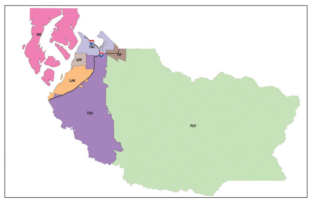
Pierce County Submarket Legend. Pierce County Submarket Boundaries
|
|
|
- Mabel Owen
- 5 years ago
- Views:
Transcription
1
2 Pierce County Submarket Legend FIF Fife PUY Puyallup UPF University Place, Fircrest GIG Gig Harbor TNC Tacoma North, Central LAT Lakewood TSO Tacoma South Pierce County Submarket Boundaries Boundaries start at the northwest corner and read clockwise, following census tract boundaries. FIF Fife North: The northwest corner of the Fife submarket starts at a point in the Port of Tacoma area where there are no roads. This point can be determined by drawing a line due north from where I-5 crosses the Puyallup River. An east/west line can be drawn from the intersection of Taylor Way and Marine View Drive, which is to the east. From this intersection, imagine a line that extends north from 54 th Ave. E to the King County line. The boundary then goes in a southeasterly direction along the county line to I-5, and then due east from I-5 where it parallels 1 ST Street E, and further to the east, Alder Street, which are located in Milton. East: Meridian Ave. E South: Puyallup River West: At a point where I-5 crosses the Puyallup River on a line due north GIG Gig Harbor North: Kitsap County line East: The Narrows South: Puget Sound West: Henderson Bay LAK Lakewood North: Chambers Creek, Chambers Creek Park, 64 th Street W, Orchard Street W, 80 th Street S East: I-5. At a point south of Hwy 512 on I-5, there is a small area of apartments on the east side of I-5 that is contiguous to McChord Air Force Base. It is formed on the east by the Burlington Northern Santa Fe railroad tracks and McChord Drive SW on the south where it intersects I-5. Proceed south of this intersection on I-5 for about 1.5 miles and there is another small apartment area that protrudes east of I-5 into an area bordered by the Fort Lewis Military Reservation. It can only be accessed by I- 5 at Exit 123 where N Thorne Lane SW turns into Murray Road SW. The boundary continues southeasterly along I-5 toward the Thurston County line. South: I-5 near Thurston County, the Tacoma South submarket crosses north into a portion of the south part of the Lakewood boundary. This land belongs to Fort Lewis and is south of Dupont. The southernmost point of the Lakewood submarket crosses into the Nisqually Estuary where it meets the Thurston County line. Dupont and Steilacoom are in this submarket. West: Thurston County line, Puget Sound
3 PUY Puyallup North: Puyallup River where it is crossed by I-5, Meridian Ave. E, King County line East: Cascade foothills South: Thurston County line West: North from the Thurston County boundary in a meandering line that passes through Fort Lewis and connects with 22 nd Ave. E, 152 nd Street E, Waller Rd. E, Brookdale Rd. E, Golden Given Rd. E, 112 th St. E, 22 nd Ave. E, 97 th St. E, 24 th Ave. E, 84 th Street E, 20 th Ave. E, 72 nd St. E, E border of Swan Creek Park north to where I-5 crosses the Puyallup River TNC Tacoma North, Central North: Point Defiance Park, Commencement Bay to the King County line East: King County line to a point that 54 th Ave. E would intersect if it continued north to the county line. At a point where Marine View Drive and Taylor Way intersect, go east to a point in the Port of Tacoma area that would be due north of where I-5 and the Puyallup River intersect. There are no streets to reference the last part of this description. South: I-5, Hwy 16, S 19 th Street West: The Narrows TSO: - Tacoma South North: Hwy 16 at S 19 th Street, I-5 East: Refer to the west boundary of Puyallup South: Thurston County line West: Begin at the Thurston County line in a northeasterly direction on I-5. Close to the county line TSO extends across I-5 to the northwest just south of Dupont. This land belongs to Fort Lewis. Further north on I-5 there are two small areas containing apartments on the east side of I-5, which are in the city of Lakewood (LAK). Refer to Lakewood (East). Continue north on I-5 to 80 th Street S, Orchard Street W, S 19 th Street UPF University Place, Fircrest North: S 19 th Street East: Orchard Street W South: 64 th Street W, Chambers Creek Park, Chambers Creek West: The Narrows
4 SIL PBI BRM POR
5 Kitsap County Submarket Legend BRM Bremerton POR Port Orchard PBI Poulsbo, Bainbridge Island SIL Silverdale Kitsap County Submarket Boundaries Boundaries start at the northwest corner and read clockwise, following census tract boundaries. BRM Bremerton North: Newberry Hill Road, Dyes Inlet, NW Schuyler Road, Holland Road Northwest, NW 64 th Street, Central Valley Road NW, NE Waaga Way, NE Gluds Pond Road, Brownsville Highway east to Port Orchard Bay East: Puget Sound South: Puget Sound West: Area approximately ½ mile west of Highway 3 PBI Poulsbo, Bainbridge Island This submarket is distinct and separated from the closest submarket, Silverdale, by such a long distance, that a boundary description is not necessary. POR Port Orchard North: Puget Sound East: Highway 3 South: Highway 160 in a line due west to Highway 3 West: Puget Sound SIL - Silverdale North: A north boundary has not been delineated due to the great distance to Poulsbo to the north East: Highway 3 South: Newberry Hill Road, Dyes Inlet, NW Schuyler Road, Holland Road Northwest, NW 64 th Street, Central Valley Road NW, NE Waaga Way, NE Gluds Pond Road, Brownsville Highway east to Puget Sound West: Puget Sound
6 OLY LCY TUM \]^I5
7 Thurston County Submarket Legend LCY Bremerton OLY Port Orchard TUM Tumwater Thurston County Submarket Boundaries Boundaries start at the northwest corner and read clockwise, following census tract boundaries. LCY Lacey North: I-5 East: Nisqually River South: South of Yelm Highway West: Rainier Road SE, the railroad tracks in a southwesterly direction for a short stretch north of Country Ridge Drive, Chehalis Western Trail to Yelm Highway, then westerly on Yelm Highway, north on Wiggens Road SE, west on 27 th Avenue SE, north on Hoffman Drive, east on 18 th Avenue SE, north on Fones Road, east on Pacific Avenue, north on Lilly Road until I-5. OLY Olympia North: Puget Sound East: Puget Sound to where South Bay Road NE intersects with Hawks Prairie Road NE, then in a southeasterly direction to Carpenter Road NE, west on I-5, south on Lilly Road SE, west on Pacific Avenue, south on Fones Road, west on 18 th Avenue SE, south on Hoffman Drive, east on 27 th Avenue SE, south on Wiggens Road, southeasterly on Yelm Highway, southeasterly on the Chehalis Western Trail,, northeasterly on the railroad tracks north of Country Ridge Drive, southeasterly on Rainier Road SE to Fort Lewis. South: Rich Road SE, Old Highway 99, Henderson Blvd. SE, west on North Street and Custer Way, north on I-5, northwesterly on Highway 101 West: Eld Inlet TUM Tumwater North: Highway 101, south on I-5, east on Custer Way and North Street East: Henderson Blvd., Old Highway 99 South: Into the countryside West: Black Lake Blvd. SW northeasterly to Highway 101
TACOMA (SEATTLE), WASHINGTON
, WASHINGTON") TACOMA (SEATTLE), WASHINGTON THE TACOMA TRANSFORMATION Nestled between Seattle and Olympia, Tacoma is quickly becoming a beacon for economic growth in the South Sound region. The third largest city in
TACOMA (SEATTLE), WASHINGTON THE TACOMA TRANSFORMATION Nestled between Seattle and Olympia, Tacoma is quickly becoming a beacon for economic growth in the South Sound region. The third largest city in
Washington. Telephone: Ryan Rd Buckley, WA Telephone: Burlington, WA Telephone:
 Washington Aberdeen 516 E 1st St Aberdeen, WA 98520 Telephone: 360-533-0770 Anacortes 2511 29th St Anacortes, WA 98221 Telephone: 360-293-4455 Arlington 6911 188th St NE Arlington, WA 98223 Telephone:
TACOMA (SEATTLE), WASHINGTON
, WASHINGTON") TACOMA (SEATTLE), WASHINGTON THE TACOMA TRANSFORMATION Nestled between Seattle and Olympia, Tacoma is quickly becoming a beacon for economic growth in the South Sound region. The third largest city in
TACOMA (SEATTLE), WASHINGTON THE TACOMA TRANSFORMATION Nestled between Seattle and Olympia, Tacoma is quickly becoming a beacon for economic growth in the South Sound region. The third largest city in
Presbyterian Men's Organizations in the Synod of Alaska-Northwest. Churches in bold are chartered members of Presbyterian Men. Presbytery of ALASKA
 Presbyterian Men's Organizations in the Synod of Alaska-Northwest Churches in bold are chartered members of Presbyterian Men. Presbytery of ALASKA Chapel By The Lake Box 210607 Auke Bay AK 99821 First
Men - 3A - Team Rankings - 17 Events Scored ============================================================================= 1) Mt Spokane 81 2) Shadle
 Mt Spokane 81 2) Shadle") Pacific N.W. Track & Field Officials - Contractor License 5/27/2017-5:59 PM 2A-3A-4A- Washington State Track & Field Meet - 5/25/2017 to 5/27/2017 Mount Tahoma Stadium Men - 2A - Team Rankings - 17 Events
Pacific N.W. Track & Field Officials - Contractor License 5/27/2017-5:59 PM 2A-3A-4A- Washington State Track & Field Meet - 5/25/2017 to 5/27/2017 Mount Tahoma Stadium Men - 2A - Team Rankings - 17 Events
Operating Frequencies and Channel Asignements
 CHANNEL TEAM Operating Frequencies 1 Federal Way 146.760- (103.5) 2 Fire Zone 3 (Repeater 2) 147.04+ 2 Fire Zone 4 147.04+ 2 Federal Way 147.040+ (103.5) 3 King County EOC 145.11-(103.5) 3 King County
* ** Stanwood. Camano. School District. "k'kk
 Stanwood * ** "k'kk Camano School District TO FROM SUBJECT DATE TYPE BOARD OF DIRECTORS DR. JEAN SHUMATE, SUPERINTENDENT GARY PLATT, EXECUTIVE DIRECTOR - BUSINESS SERVICES DIRECTOR DISTRICT REBALANCING
Legend. Air Quality Zone Urban Growth Bndy. Olene. Keno Midland FOOTHILLS. //gis/data/proj/ph/airqualitybnd/aqz_map.
 LAKE KLAMATH RIVER LAKE Legend HIGHWAY 140 HIGHWAY 97 Air Quality Zone Urban Growth Bndy LAKESHORE UPPER KLAMATH LAKE MEADOW LAKE HIGHWAY 140 BIEHN LONG LAKE 5TH CRATER LAKE FOOTHILLS LAKE EWAUNA 6TH ROUND
CITY OF SNOHOMISH Snohomish, Washington ORDINANCE 2019 AN ORDINANCE OF THE CITY OF SNOHOMISH, WASHINGTON ESTABLISHING A NEW LAND USE DESIGNATION MAP.
 OF SNOHOMISH Snohomish, Washington ORDINANCE 2019 AN ORDINANCE OF THE OF SNOHOMISH, WASHINGTON EABLISHING A NEW LAND USE DESIGNATION MAP. WHEREAS, the City Council considers long-range planning as embodied
LAND PARCELS All Counties
 Photo PIERCE COUNTY Narrows Ridge 3230 N Narrows Dr 46.32 Acres $7,900,000 Residential UNDER CONTRACT 62-lot planned high-end residential community with gated access Mix of partial and complete view lots
NORTH BEND, WASHINGTON
 NORTH BEND, WASHINGTON PROPERTY OVERVIEW NORTH BEND PREMIUM OUTLETS NORTH BEND, WA MAJOR METROPOLITAN AREA SELECT TENANTS 405 203 NORTH BEND PREMIUM OUTLETS Seattle: RETAIL GLA (sq. ft.) 224,000; 50 stores
Bill 215 (Private) An Act to amend the charter of the City of Laval
 An Act to amend the charter of the City of Laval") SECOND SESSION THIRTY-SIXTH LEGISLATURE Bill 215 (Private) An Act to amend the charter of the City of Laval Introduced 8 May 2002 Passage in principle 14 June 2002 Passage 14 June 2002 Assented to 14 June
SECOND SESSION THIRTY-SIXTH LEGISLATURE Bill 215 (Private) An Act to amend the charter of the City of Laval Introduced 8 May 2002 Passage in principle 14 June 2002 Passage 14 June 2002 Assented to 14 June
Welcome! This open house provides an early look at: Garage layout and access Potential pedestrian, bicycle and transit improvements
 Welcome! Sound Transit is improving access to Station for drivers, pedestrians, bicyclists and bus riders, including construction of a new garage. This open house provides an early look at: Garage layout
ORDINANCE NO. 612, DESCRIPTION ATTACHED
 Insert BOARD OF TRUSTEES, TOWN or PAGOSA SPRINGS STATE OF COLORADO ORDINANCE NO. 612, AMENDING ORDINANCE NO. 561, ESTABLISHING THE TOWN OF PAGOSA SPRINGS SANITATION ENERAL IMPROVEMENT DISTRICT, TO CLARIFY
DIRECTIONS TO SITES. Arlington School District
 DIRECTIONS TO SITES Arlington School District Haller Middle School (360) 618-6403 600 E. 1 st Street Arlington, WA 98223 1. Off Hwy 9, turn east on E. Highland Drive 2. Turn north on S. French Ave 3. Turn
City of North Liberty
 City of North Liberty City Council Agenda Special Session August 3, 11 AGENDA North Liberty City Council August 3, 11 Special Session :3 p.m. Council Chambers 1. Call to order.. Roll call. 3. Approval
THURSTON COUNTY HERITAGE REGISTER
 THURSTON COUNTY HERITAGE REGISTER Case No. Name & Address of Property Action:* Date Built Area Style TCHR-86- TCHC-86- TCHR-86-3 3 TCHR-86- TCHR-87-5 TCHR-87-6 TCHR-87-3 7 TCHR-87-0 8 Jaaska House/Barn
INDUSTRIAL SPACE Pierce/South Counties
 Photo PIERCE COUNTY LPC Frederickson ONE 38 th Ave E & 200 th St E Frederickson, WA www.fredericksonone.com Frederickson Pacific Industrial Park 38 th Ave E & 200 th St E Frederickson, WA Bldg 1 Bldg 2
NORTH BEND PREMIUM OUTLETS
 NORTH BEND PREMIUM OUTLETS THE SIMON EXPERIENCE WHERE BRANDS & COMMUNITIES COME TOGETHER More than real estate, we are a company of experiences. For our guests, we provide distinctive shopping, dining
Available Land - Pierce County
 Frederickson 4 38 2th St E Frederickson, WA 98446 $. Build to suit for sale or lease. 5, SF - 817, SF. 39.97 acres @ $4.5/SF. SEPA approved.. Building SQFT: 817, Max SF: 1 $7,663,793 Price Per SQFT: $9.38
Title VI Service Equity Analysis
 Pierce Transit Title VI Service Equity Analysis Pursuant to FTA Circular 4702.1B September 2013 Service Change February 2013 Page intentionally left blank PIERCE TRANSIT TITLE VI SERVICE EQUITY ANALYSIS
Here Insert Name and Title of the Officer personally appeared Name(s) of Signer(s)
 of Signer(s)") CALIFORNIA ALL-PURPOSE ACKNOWLEDGMENT CIVIL CODE 1189 A notary public or other officer completing this certificate verifies only the identity of the individual who signed the document to which this certificate
CALIFORNIA ALL-PURPOSE ACKNOWLEDGMENT CIVIL CODE 1189 A notary public or other officer completing this certificate verifies only the identity of the individual who signed the document to which this certificate
Downtown to Defiance Trolley Key Messages Jan. 2017
 Downtown to Defiance Trolley Key Messages Jan. 2017 Overarching Messages This is a demonstration (pilot) project for one summer. We will evaluate how it went to see if we can offer it again in the future.
PETITION TO CONTINUE THE DOWNTOWN DES MOINES SELF-SUPPORTED MUNICIPAL IMPROVEMENT DISTRICT PURSUANT TO CHAPTER 386, CODE OF IOWA
 PETITION TO CONTINUE THE DOWNTOWN DES MOINES SELF-SUPPORTED MUNICIPAL IMPROVEMENT DISTRICT PURSUANT TO CHAPTER 386, CODE OF IOWA We, the undersigned, being at least 25 per cent of all owners of property
PORTS IN WASHINGTON STATE
 PORTS IN WASHINGTON STATE New Market Industrial Campus and Tumwater Town Center Real Estate Development Master Plan Public Meeting #1 March 5, 2015 Founded in 2005, Community Attributes Inc. (CAI) tells
2009 MELL High School Surveys 2007 MELL High School Surveys 2004 WL High School Surveys. # Submitted Survey
 Aberdeen 2 2 100 2 2 100 2 0 0 Adna 1 1 100 1 1 100 1 1 100 Anacortes 3 3 100 3 3 100 3 0 0 Arlington 3 3 100 3 3 100 3 0 0 Asotin Anatone 1 1 100 1 1 100 1 0 0 Auburn 3 3 100 3 3 100 3 2 67 Bainbridge
All that part of Lot 11, Sunset Hill, a subdivision in the City of Overland Park, Johnson County, Kansas, more particularly described as follows:
 NOTICE OF PUBLIC HEARING CITY PLANNING COMMISSION CITY OF OVERLAND PARK, KANSAS Notice is hereby given that the City Planning Commission of Overland Park, Kansas, will hold a public hearing Monday, February
Events Around the Sound - September 25th-October 1st
 Thurston County Through the Decades: 1850-1875 Start 10/1 10:00AM - 4:00PM Tumwater Falls Park http://www.tumwaterhistoricalassociation.org/specialevents.html 110 Deschutes Way SW, Tumwater, WA 98501 360-539-8839
All questions in this survey were voluntary; all results are based on number of respondents who answered the relevant question.
 Online Survey Results Sound Transit 3 Draft Plan Introduction An online survey was one of the primary methods employed to solicit feedback on Sound Transit 3 Draft Plan. The results of the March 29 May
SANBORN FIRE INSURANCE ATLAS COLLECTION CALIFORNIA STATE UNIVERSITY, NORTHRIDGE (CSUN) OVIATT LIBRARY MAP COLLECTION
 OVIATT LIBRARY MAP COLLECTION") SANBORN FIRE INSURANCE ATLAS COLLECTION CALIFORNIA STATE UNIVERSITY, NORTHRIDGE (CSUN) OVIATT LIBRARY MAP COLLECTION The Sanborn Fire Insurance Atlas Collection at contains more than 4,000 individual Sanborn
SANBORN FIRE INSURANCE ATLAS COLLECTION CALIFORNIA STATE UNIVERSITY, NORTHRIDGE (CSUN) OVIATT LIBRARY MAP COLLECTION The Sanborn Fire Insurance Atlas Collection at contains more than 4,000 individual Sanborn
H 7766 AS AMENDED S T A T E O F R H O D E I S L A N D
 ======= LC0 ======= 0 -- H AS AMENDED S T A T E O F R H O D E I S L A N D IN GENERAL ASSEMBLY JANUARY SESSION, A.D. 0 A N A C T RELATING TO STATE AFFAIRS AND GOVERNMENT -- SOVEREIGNTY AND JURISDICTION
Participating Retailers
 Participating Retailers Cedar Grove Facilities cedar-grove.com Maple Valley Seattle Woodinville 3620 36th PL NE, WA 98201 17825 Cedar Grove RD SE, Maple Valley WA 98038 7343 E Marginal Way S, Seattle WA
SPECIAL USE PERMIT - SUP West 159th Street. SBMS cell site 4459, Lot 1, a subdivision in Overland Park, Johnson County, Kansas.
 NOTICE OF PUBLIC HEARING CITY PLANNING COMMISSION CITY OF OVERLAND PARK, KANSAS Notice is hereby given that the City Planning Commission of Overland Park, Kansas, will hold a public hearing Monday, May
CITY COUNCIL AGENDA ITEM CITY OF SHORELINE, WASHINGTON
 Council Meeting Date: August 8, 2016 Agenda Item: 8(a) CITY COUNCIL AGENDA ITEM CITY OF SHORELINE, WASHINGTON AGENDA TITLE: Adoption of Resolution No. 393 Stating the City Council s Support for Sound Transit
JOB PERFORMED NAME ADDRESS PHONE NUMBER APPLIANCES th St SW, #B Lakewood, WA 98499
 COMPANY NAME Lakewood Appliance Appliances none Welches Appliances Appliances none JOB PERFORMED NAME ADDRESS PHONE NUMBER EMAIL APPLIANCES 6111 100th St SW, #B Lakewood, WA 98499 253-584-2277 - office
BROWARD COUNTY MANATEE PROTECTION ZONES
 MANATEE PROTECTION ZONES For description of zone boundaries see: 68C-22.00 F.A.C for State Manatee Protection Zones last amended /4/20 For infomation please call or write to: Fish and Wildlife Conservation
Table B-1: P&RS Park and Facility Inventory by Classification 1 Outdoor Recreation Amenities Park Structures
 Appendix B: Park and Facility inventory APPENDIX B: PARK AND FACILITY INVENTORY Table B-1: P&RS Park and Facility Inventory by Classification 1 Outdoor Recreation Amenities Site Amenities Park Structures
JOB PERFORMED NAME ADDRESS PHONE NUMBER APPLIANCES th St SW, #B Lakewood, WA 98499
 COMPANY NAME Lakewood Appliance Appliances none JOB PERFORMED NAME ADDRESS PHONE NUMBER EMAIL APPLIANCES 6111 100th St SW, #B Lakewood, WA 98499 253-584-2277 - office 253-588-5712 - fax lakewoodappl.workorders@gmail.com
COMPOST Participating Retailers
 COMPOST Participating Retailers Cedar Grove Facilities cedar-grove.com Maple Valley Seattle Woodinville Ace Hardware acehardware.com Fairwood Highlands Maple Leaf North Bend Dunn Lumber dunnlumber.com
CLIENT: CITY OF SUN PRAIRIE 300 EAST MAIN STREET SUN PRAIRIE, WI OWNER: MART ENTERPRISES, LLC SOUTH WILDWOOD STREET TOWN BURKE LOT 1
 SOUTH DRIVE SOUTH DRIVE maxwell shot after standing it up straight texted coordinates XXXXXXXXXX XXX PROJECT NO. DRAWN BY: SURVEYOR: FILE NO. SHEET NO. 00036147 B. TISDALE B. TISDALE 00036147 1 1 ARCHITECTURE
1) AMENDMENTS TO THE ROCKINGHAM ZONING BYLAW MAPS:
 AMENDMENTS TO THE ROCKINGHAM ZONING BYLAW MAPS:") 143 144 145 1) AMENDMENTS TO THE ROCKINGHAM ZONING BYLAW MAPS: a. Changing the zone of that land located on the east side of Westminster Street, Bellows Falls, and bounded on the north by the south property
143 144 145 1) AMENDMENTS TO THE ROCKINGHAM ZONING BYLAW MAPS: a. Changing the zone of that land located on the east side of Westminster Street, Bellows Falls, and bounded on the north by the south property
Puget Sound Trends. Executive Board January 24, 2019
 Puget Sound Trends Executive Board January 24, 2019 Overview Topics covered in today s presentation: How many jobs are there? Housing Trends Where do people work? How long does it take to get to work?
2016 Pharmacy Directory
 Washington Health Alliance Medicare HMO 2016 Pharmacy Directory This pharmacy directory was updated on July 1, 2016. For more recent information or other questions, please contact Health Alliance Medicare
Figure 1: Little Dry Creek Trail Crossing
 Figure 1: Little Dry Creek Trail Crossing Figure 2: Little Dry Creek Trail Crossing Northwest Rail Environmental Evaluation Temporary Trail Detour Concurrence Form Adams County, Little Dry Creek Trail
GUIDE TO THE GREAT EASTERN TRAIL IN TENNESSEE
 GUIDE TO THE GREAT EASTERN TRAIL IN TENNESSEE FIRST EDITION, SEPTEMBER 2011 Covers Section TN1 Base of Lookout Mountain to Soddy Daisy, TN THIS GUIDE IS NOT FOR SALE OR RESALE Guide To The Great Eastern
Spanaway Business Directory
 28 Janitorial & Maintenance to Libraries Janitorial & Maintenance Ann s Janitorial Service 18407 Pacific Avenue So. #24 253-846-3923 Doris Hill Building Maintenance 111 158th Street Court E. 253-537-8960
The Washington DA List
 Andrew K. Miller Benton County 7122 W. Okanogan Place Kennewick, WA 99336 Phone (509) 735-3591 Fax (509) 736-3066 Arthur D. Curtis Clark County P.O. Box 5000 Vancouver, WA 98666 Phone (360) 397-2016 Fax
BE IT ORDAINED by the Mayor and the City Council of the City of Papillion as follows:
 ORDINANCE NO. 1798 AN ORDINANCE TO AMEND CHAPTER 24, SECTION 1 DELINEATING THE VOTING BOUNDARY WARDS FOR THE CITY OF PAPILLION; TO REPEAL THE EXISTING CHAPTER 24, SECTION 1; AND TO PROVIDE FOR AN EFFECTIVE
Most Recent Population, Property Tax, and Sales Tax Distribution Data for Cities/Towns (2017)
") Most Recent Population, Property Tax, and Sales Tax Distribution Data for Cities/Towns (2017) Data sources: Washington State Office of Financial Management, Washington State Department of Revenue, Washington
Most Recent Population, Property Tax, and Sales Tax Distribution Data for Cities/Towns (2017) Data sources: Washington State Office of Financial Management, Washington State Department of Revenue, Washington
SPECIAL USE PERMIT - SUP Blue Valley Parkway
 NOTICE OF PUBLIC HEARING CITY PLANNING COMMISSION CITY OF OVERLAND PARK, KANSAS Notice is hereby given that the City Planning Commission of Overland Park, Kansas, will hold a public hearing Monday, April
City of Tacoma Community and Economic Development Department
 Agenda Item GB-2 City of Tacoma Community and Economic Development Department TO: FROM: SUBJECT: Planning Commission Shirley Schultz, Principal Planner, Current Planning Division Billboard Regulations
ORDINANCE NO. 510 THEREFORE, BE IT ORDAINED BY THE GOVERNING BODY OF THE CITY OF BEL AIRE, KANSAS:
 (Published in The Ark Valley News on July, 2012.) ORDINANCE NO. 510 S-I-1 GILMORE & BELL, P.C. 07/11/2012 AN ORDINANCE CREATING A COMMUNITY IMPROVEMENT DISTRICT IN THE CITY OF BEL AIRE, KANSAS; AUTHORIZING
2016 Regional Transportation Alternatives Program (TAP) Grant Application
 Grant Application") 2016 Regional Transportation Alternatives Program (TAP) Grant Application PROJECT TITLE: Yelm-Tenino Trail Extension Feasibility Study TRPC use only GENERAL PROJECT INFORMATION Agency or Organization City
2016 Regional Transportation Alternatives Program (TAP) Grant Application PROJECT TITLE: Yelm-Tenino Trail Extension Feasibility Study TRPC use only GENERAL PROJECT INFORMATION Agency or Organization City
Exploring Drivers of Fecal Coliform Pollution Trends in the Puget Sound. Washington Commercial Shellfish
 9/22/2016 Exploring Drivers of Fecal Coliform Pollution Trends in the Puget Sound Authors: Lindsey Hamilton, Scott Berbells, Lawrence Sullivan, Jean Snyder Washington State Department of Health Washington
MARTIN COUNTY MANATEE PROTECTION ZONES
 MANATEE PROTECTION ZONES For description of zone boundaries see: 68C-22.024 F.A.C for State Manatee Protection Zones last amended 2/24/990 For infomation please call or write to: Fish and Wildlife Conservation
APPENDIX H Transportation Projects Considered for Cumulative Impact Analysis
 Final Supplemental Environmental Impact Statement on the Regional Transit Long-Range Plan APPENDIX H Transportation Projects Considered for Appendix H Transportation Projects Considered for Cumulative
APHIS Expands the Citrus Greening (Candidatus Liberibacter asiaticus) Quarantined Area in Texas
 Quarantined Area in Texas") FOR INFORMATION AND ACTION DA-2014-47 October 28, 2014 Subject: To: APHIS Expands the Citrus Greening (Candidatus Liberibacter asiaticus) Quarantined Area in Texas State and Territory Agricultural Regulatory
FOR INFORMATION AND ACTION DA-2014-47 October 28, 2014 Subject: To: APHIS Expands the Citrus Greening (Candidatus Liberibacter asiaticus) Quarantined Area in Texas State and Territory Agricultural Regulatory
M I N U T E S OKLAHOMA COUNTY PLANNING COMMISSION
 M I N U T E S OKLAHOMA COUNTY PLANNING COMMISSION March 18, 2004 1:30 p.m. The meeting of the Oklahoma County Planning Commission convened and was called to order by Mr. Will Jones, Vice-Chairperson, at
Albany. Corvallis Florence Green Trees. Philomath Florence Town Hayden Bridge Halsey McKenzie Valley
 Newport Newport Waldport Yachats See Florence/ Dunes City Map Toledo Lincoln County 230 Albany 225 - Florence Coast Village 234 - Pleasant Hill/Oakridge Corvallis 226 - Florence Green Trees Linn County
IOWA ORNITHOLOGISTS' UNION - Birding Sites in Linn County
 IOWA ORNITHOLOGISTS' UNION - Birding Sites in Linn County Printed on 6/15/2018 Bever Park (ebird Hotspot) GPS Coordinates: 41.9851219,-91.6269125 Restrooms Parking Trails ADA Accessible Trails Boyson Trail
WSVMA Member House Call Veterinarians
 ALEA ALLEN - CALM SPIRIT VET SVCS. - (206) 890-5577 STACY - PAWSITIVELY PETS - (206) 890-5577 KATE - DOORSTEP VET - (253) 232-8393 HANNA - AT HOME VET - (425) 402-0187 TINA - MOBILE VET SVCS - (425) 485-7387
STOP INTERSECTIONS. Street Direction Stop Intersection
 APPENDIX A STOP INTERSECTIONS Street Direction Stop Intersection 2nd St. Southbound shall stop at Champion St. 2nd St. Northbound shall stop at Champion St. 2 nd St. Southbound shall stop at Beech St.
APPENDIX A: SCREENLINE SURVEY STATION DETAILS
 and Count Details APPENDIX A: SCREENLINE SURVEY STATION DETAILS Table 12 expands on the Quick Facts in Table 1 by providing count details for all screenlines as well as individual stations. The following
Northwest Consortium of Airports
 Project Abstract The Pacific Northwest is home to two of the country s largest cities Seattle and Portland but outside those cities much of the region is still remote and difficult to access. Driving distances
LOOPED IN WASHINGTON STATE
 LOOPED IN WASHINGTON STATE NOTE: STARRED LOCATIONS ARE AVAILABLE FOR PUBLIC RENTAL. NEW LOCATIONS IN BOLD. Seattle Alijoya Retirement Community* Bagley Wright Theatre* Bertha Knight Landes Room, Seattle
Customer Service:
 Customer Service: 1-877-905-0500 MIAMI - DADE COUNTY Medical Doctors House Calls 1-855-668-8798 8:00am - 5:00pm 1770 NE Miami Gardens Dr. Unit #1 North Miami Beach, FL 33179 (305) 949-4141 12555-C Biscayne
Regional Wayfinding Sign Strategy Thurston County Trails 2017
 Regional Wayfinding Sign Strategy Thurston County Trails 2017 Partners: Members and partnering organizations of the Thurston Thrives Community Design Action Team City of Lacey, City of Olympia, City of
Samuel Treat ( /17)
") Samuel Treat (1648 1716/17) Samuel Treat graduated from Harvard College in 1669. He was the eldest son of Robert Treat who became governor of Connecticut. He was the husband of Elizabeth Mayo who was the
Samuel Treat (1648 1716/17) Samuel Treat graduated from Harvard College in 1669. He was the eldest son of Robert Treat who became governor of Connecticut. He was the husband of Elizabeth Mayo who was the
Draw Your Future Merced 2015 Districting
 Draw Your Future Merced 2015 Districting Presentation by Douglas Johnson Current Timeline 2 1. Commission Organization March/April 2. First Round hearings May 5, 19 & 30 3. Time for public to draw plans
PASSPORT DISCOVERY. Would you like to find out more about the byway? Check us out at Thanks to Our Partners
 Thanks to Our Partners Lewis County Town of Naches City of Morton City of Mossyrock Tacoma Power Lewis County PUD Mount Rainier National Park Mount St. Helens National Monument White Pass Ski Area Visit
FOURTH SCHEDULE BYLAW SPEED LIMITS
 FOURTH SCHEDULE BYLAW SPEED LIMITS (Clause 64) 1. Aldwins from Ferry northerly, generally, along Aldwins to Marlborough Street. 2. Avonhead Park 20 km/h. 3. Avonhead Park Cemetery 20 km/h 4. Avonhead from
HIDALGO COUNTY CLOSED LANDFILL INVENTORY
 HIDALGO COUNTY CLOSED LANDFILL INVENTORY MSWLF ID FAC ID NAME SITE LOCATION PLACE OP_COMPANY 170 TX00170 CITY OF ALAMO 3 MI SE OF CITY HALL & ADJACENT TO EXISTING LANDFILL SITE ALAMO ALAMO, CITY OF 224
GREENSBORO-JAMESTOWN JOINT ANNEXATION AGREEMENT
 NORTH CAROLINA GUILFORD COUNTY GREENSBORO-JAMESTOWN JOINT ANNEXATION AGREEMENT THIS AGREEMENT, made and entered into this the day of, 2011 by and between the City of Greensboro and the Town of Jamestown.
A B D E. SET 2015 Area Map
 SET 2015 Area Map Driving route in blue. Main a rac ons have red stars. General loca ons of restaurants and fast food are outlined with yellow boxes. Miscellaneous stores listed below: A. Haggen s Grocery
Fluoridation Census SEPTEMBER -1993
 Fluoridation Census SEPTEMBER -1993 U.S. DRTMENT OF HEALTH & HUMAN SERVICES Public Health Service Centers for Disease Control and Prevention National Center for Prevention Services Division of Oral Health
GILBERT & WEST TOWN INTERCOUNTY DRAIN Windsor Township, Eaton County and City of Lansing, Delhi Township, Ingham County, Michigan
 GILBERT & WEST TOWN INTERCOUNTY DRAIN Windsor Township, Eaton County and City of Lansing, Delhi Township, Ingham County, Michigan PRELIMINARY ENGINEERING REPORT Abigail Eaton, Chair Intercounty Drains
GRANBY. 2a. From State Highway at south end of Forge Pond southerly to No. 1 Sessions, near Ludlow town line. See 10, 27, 28, 56, 57.
 Book/Year/Vol./Page 1. Road across the southeasterly corner of the town from Ludlow town Sessions, 1754 5 219 line to Belchertown town line. See 10. 2. From South Hadley town line near Cold Hill to the
CAE003 N ', W ' Columbia St. US 80 (and Market St.) once continued straight west from here. Continue east on Market St.
 once continued straight west from here. Continue east on Market St.") West to east. San Diego to Viejas Casino. CAE001 N 32 42.68', W 117 10.26' Harbor Dr and Pacific Hwy. Terminus of US 80 from 1943 to 1953. Pacific Hwy was US 101. CAE002 N 32 42.67', W 117 10.10' Harbor
West to east. San Diego to Viejas Casino. CAE001 N 32 42.68', W 117 10.26' Harbor Dr and Pacific Hwy. Terminus of US 80 from 1943 to 1953. Pacific Hwy was US 101. CAE002 N 32 42.67', W 117 10.10' Harbor
Road Scholar Gopher Science Olympiad Invitational January 6, Team #: Team Name: Names: Score:
 Road Scholar Gopher Science Olympiad Invitational January 6, 2018 Team #: Team Name: Names: Score: Welcome to Road Scholar! Your Science Olympiad team is planning a trip to an invitational tournament in
1 The Cadastral Mapping Fee Order (AR 94/2000) is amended by this Regulation.
 is amended by this Regulation.") Alberta Regulation 21/2005 Surveys Act CADASTRAL MAPPING FEE AMENDMENT ORDER Filed: March 2, 2005 For information only: Made by the Minister of Sustainable Resource Development (M.O. 03/2005) on February
Alberta Regulation 21/2005 Surveys Act CADASTRAL MAPPING FEE AMENDMENT ORDER Filed: March 2, 2005 For information only: Made by the Minister of Sustainable Resource Development (M.O. 03/2005) on February
20. Rainier Beach 3A fewest pts. since Garfield 4A
 HISTORICAL PERSPECTIVE AND STATISTICAL ANALYSIS - WASHINGTON STATE TRACK AND FIELD (through 2014) by Rod Wilcox King s H.S. Since 1924 Washington State has held Track and Field state championships. There
CGV - CSC Arrivals Mall Coomera Sports Centre
 ATHLETES AND TEAM OFFICIALS BUS ROUTE - 480 (DSSA/Coomera) - PRIMARY TO VENUE To Venue CGV - CSC Arrivals Mall Coomera Sports Centre Commence - Arrivals Mall Parklands Dr Left at traffic lights Smith Street
IN THE CHANCERY COURT OF LAMAR COUNTY, MISSISSIPPI CIVIL ACTION NO.: CITY OF HATTIESBURG, MISSISSIPPI
 IN THE CHANCERY COURT OF LAMAR COUNTY, MISSISSIPPI IN THE MATTER OF THE INCORPORATION OF THE CITY OF BELLEVUE, MISSISSIPPI, BELLEVUE INCORPORATORS VS. CITY OF HATTIESBURG, MISSISSIPPI PETITIONERS CIVIL
FHWA Actions on Past Interstate Requests that were approved by the USRN were presented and conditions were lifted. FHWA Approval Date
 SPECIAL COMMITTEE ON US ROUTE NUMBERING MEETING MINUTES FOR OCTOBER 17, 2013 AND REPORT TO SCOH OCTOBER 18, 2013 SHERATON DOWNTOWN DENVER, DENVER, COLORADO ADDENDUM OCTOBER 28, 2013 The meeting of the
Department of Public Works Streets & Grounds Maintenance Division. Ice & Snow Control Manual
 Department of Public Works Streets & Grounds Maintenance Division Ice & Snow Control Manual Schedule I Anti-icing Routes Hot List & Entire System Anti-icing with salt brine is only applicable above pavement
SERVICE AREA BOUNDARIES Beginning SFY2018
 SERVICE AREA BOUNDARIES Beginning SFY2018 Service Area A (1) Boundaries -- all of Ray County Ray County Fellowship Senior Center 1015 West Royle Richmond, Missouri 64085 Service Area B Beginning at I-435
Kitsap Transit Board Workshop January 16, 2018
 Kitsap Transit Board Workshop January 16, 2018 Agenda Phase II Outreach: What We Heard Next Steps TRANSFORM Comprehensive TRANSIT: Route Let s Analysis map our future together Phase II Outreach: What We
Hazardous Materials Technical Report Oregon Department of Transportation. Appendix B. Field Survey Photo Log
 Report Oregon Department of Transportation Appendix B. Field Survey Photo Log No. 1 7/25/17 Southwest View of Site 18, Sherwin- Williams (30 NE Broadway), along NE Victoria Avenue. This building is proposed
RESOLUTION GRANTING A TWO YEAR EXTENSION TO SURE SANITATION SERVICE FOR RESIDENTIAL GARBAGE COLLECTION IN ORANGE counn
 RESOLUTION GRANTING A TWO YEAR EXTENSION TO SURE SANITATION SERVICE FOR RESIDENTIAL GARBAGE COLLECTION IN ORANGE counn WHEREAS, SURE SANITATION SERVICE is currently a licensed franchisee b~ ORANGE COUNTY
SOUTHAMPTON. 4. Road along the Southampton Holyoke town line. Sessions, See 1, 51. Plan on File. (Plan 8)
") Book/Year/Vol./Page 1. Road from Northampton to Westfield, probably along Line Street on Sessions, 1747 5 31 easterly boundary of town. See 4, 12a, 51. 2. Not in Southampton 3. The road from Easthampton
Book/Year/Vol./Page 1. Road from Northampton to Westfield, probably along Line Street on Sessions, 1747 5 31 easterly boundary of town. See 4, 12a, 51. 2. Not in Southampton 3. The road from Easthampton
WASHINGTON CROSS COUNTRY STATE CHAMPIONSHIPS STATISTICAL ANALYSIS
 WASHINGTON CROSS COUNTRY STATE CHAMPIONSHIPS STATISTICAL ANALYSIS 2017 PRESTATE ANALYSIS - (POST STATE ANALYSIS BELOW) By Will Woodward (ran 15:25 at Sun Willows 1993) and Rod Wilcox King s XC Coach since
WASHINGTON CROSS COUNTRY STATE CHAMPIONSHIPS STATISTICAL ANALYSIS
 WASHINGTON CROSS COUNTRY STATE CHAMPIONSHIPS STATISTICAL ANALYSIS 2016 PRESTATE ANALYSIS - (POST STATE ANALYSIS BELOW) By Will Woodward (ran 15:25 at Sun Willows 1993) and Rod Wilcox King s XC Coach since
North Bend. Tanner. Wilderness Rim
 Valley School District - Second Proposed Board Districts as Approximated Using Census 2010 Geography High Bridge Baring Duvall Skykomish Lake Marcel-Stillwater Union Hill-Novelty Hill Carnation Ames Lake
KEWEENAW COUNTY ROADS WITH SEASONAL RESTRICTIONS
 KEWEENAW COUNTY ROADS WITH SEASONAL RESTRICTIONS ALLOUEZ TOWNSHIP PRIMARY ROADS WITH SEASONAL RESTRICTIONS 1ST STREET US 41 AHMEEK NUMBER SIX RD. 0.56 AHMEEK ST. NUMBER SIX RD. COUNTY LINE 0.39 BUMBLETOWN
Bruce Cheever railroad photographs,
 Bruce Cheever railroad photographs, 1890-1977 Overview of the Collection Creator Cheever, Bruce Title Bruce Cheever railroad photographs Dates 1890-1977 (inclusive) 1890 1977 Quantity 3 Linear Ft., ()
Centennial Airport Flight school practice areas. A PowerPoint Presentation By Michael Shannon Chief Flight Instructor Aspen Flying Club
 Centennial Airport Flight school practice areas A PowerPoint Presentation By Michael Shannon Chief Flight Instructor Aspen Flying Club The Denver metro area airspace is very complex and congested. Centennial
Public Notice for Waiver of Aeronautical Land-Use Assurance. AGENCY: Federal Aviation Administration (FAA), DOT
, DOT") This document is scheduled to be published in the Federal Register on 07/18/2016 and available online at http://federalregister.gov/a/2016-16937, and on FDsys.gov [4910-13] DEPARTMENT OF TRANSPORTATION
This document is scheduled to be published in the Federal Register on 07/18/2016 and available online at http://federalregister.gov/a/2016-16937, and on FDsys.gov [4910-13] DEPARTMENT OF TRANSPORTATION
The Geological Pacific Northwest. Wednesday February 6, 2012 Pacific Northwest History Mr. Rice
 The Geological Pacific Northwest Wednesday February 6, 2012 Pacific Northwest History Mr. Rice 1 Free Response #2 Please do not simply list the items for this response. Full sentences!!! Minimum of 3-5
22 Dakota County. Dakota County Advertising List February 4,2019 EVERYTHING IN YELLOW IS PAID AS OF 2/20/19 DISTRICT PARCEL
 22 Dakota County Dakota County Advertising List February 4,2019 EVERYTHING IN YELLOW IS PAID AS OF 2/20/19 DISTRICT PARCEL MULTI YR *** DRAINAGE * LEGAL TOTALDUE 1 5 220068518 THAT PART OF THE W1/2 NW1/4
Wright City Business Park
 Wright City Business Park 51.69 Acres SITE Wright City Business Park is a 51.69 acre site ideal for large distribution or manufacturing uses. Located approximately ¼ mile west of I-70 exit 199, Wright