ROUTE 20 CORRIDOR STUDY ---- Orange County, Virginia
|
|
|
- Miranda Booth
- 5 years ago
- Views:
Transcription
1
2 ROUTE 20 CORRIDOR STUDY ---- Orange County, Virginia Prepared by PARSONS Fairfax, Virginia on behalf of the: Rappahannock-Rapidan Regional Commission in cooperation with Orange County, Virginia Virginia Department of Transportation and Federal Highway Administration July 2006 The contents of this report reflect the views of the authors, who are responsible for the facts and accuracy of the data presented herein. The contents do not necessarily reflect the official views or policies of the Federal Highway Administration (FHWA) or the Commonwealth Transportation Board. This report does not constitute a standard specification or regulation. FHWA acceptance of this report as evidence of fulfillment of the objectives of this planning study does not constitute approval of location and design or a commitment to fund any recommended improvements. Additional project-level environmental impact assessments and/or studies of alternatives may be necessary.
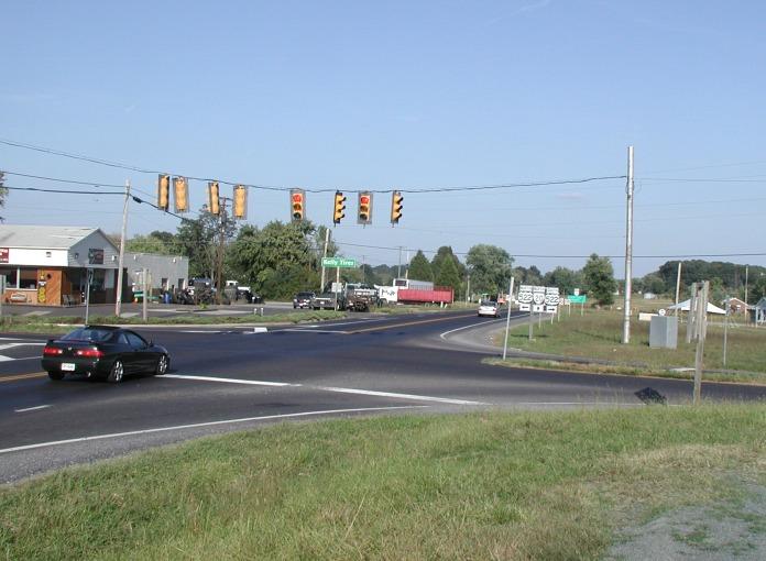
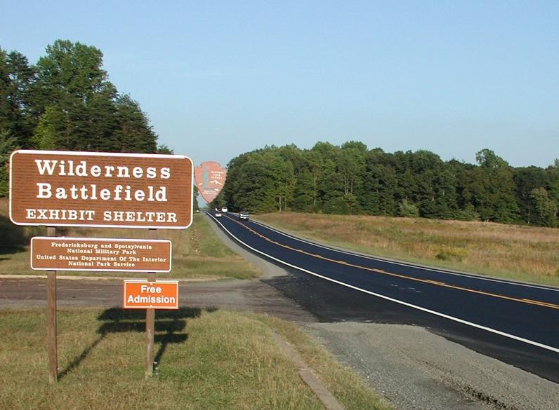
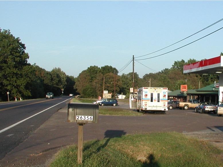
3 Executive Summary This study examined 13.4 miles of Virginia Route 20 in Orange County, extending from US Route 522 at Unionville to Virginia Route 3 at Wilderness. Route 20 is the major east-west highway in Orange County, serving residents and businesses in central and eastern Orange County as well as connecting population centers in Orange County and the Town of Orange with the Fredericksburg region s Route 3 and I-95 corridors. Route 20 is a two-lane rural highway with access to driveways and secondary roads provided by at-grade intersections. Traffic signals are located at two intersections, the US Route 522 (Zachary Taylor Highway) intersection with Route 20; and the Virginia Route 3 (Germana Highway) intersection with Route 20. All other intersections on Route 20 are controlled by stop signs on the side streets. This study seeks to develop a framework for transportation planning in the corridor, and to assist in efforts to provide improvements to better serve traffic flow and safety, as well as to preserve the rights-of-way that will be needed to serve existing and future travel demands. The study identified transportation concerns and recommendations based on existing conditions (traffic and roadway geometrics), and identified recommendations to address these same concerns for a planning horizon of 20 years or more (the planning horizon for the study is 2030). The study process included traffic counts, traffic forecasts, roadway operations analysis, reviews and analyses of traffic accident reports, and observation of roadway operations and safety in the field. Public involvement also played a key role in the study, and outreach meetings to stakeholders and the general public were held early in the study to assist in identifying transportation concerns, and later in the study to allow for public review and comment on preliminary recommendations. Public hearings to take official comment were held as part of the review and adoption process by the Orange County Planning Commission and Board of Supervisors. Existing and future transportation concerns in the study corridor, as identified by the traffic engineering analyses as well as public input, include overall capacity and safety concerns, as well as location-specific concerns. Preserving and enhancing the functionality and safety of the corridor through both growth management and access management are also major issues within the study corridor. The Wilderness Battlefield in the eastern portion of the study corridor is both a local and national historic resource, and balancing transportation needs with the preservation of the battlefield and surrounding areas is also a key concern. Throughout the study corridor, Route 20 is a two-lane undivided rural roadway with generally 12-foot travel lanes. Shoulder widths generally vary from 1 to 3 feet. With the exception of the two signalized intersections in the study corridor, a westbound right turn lane on Route 20 at its intersection with Route 611, and turn lanes for the Locust Grove Elementary and Middle Schools, there are currently no turn lanes at the intersections along Route 20. This lack of turn lanes was cited as a major need in the corridor. ES-1
4 The following locations were identified by the analysis as well as public input as areas of particular concern for existing traffic flow and/or safety: Intersection and vicinity of Route 20 and Route 650 (Independence Road) Intersection and vicinity of Route 20 and Route 621 South (Mine Run Road) Portion of Route 20 east of Route 692 (Burr Hill Road/Grasty Gold Mine Road) Intersection and vicinity of Route 20 and Route 611 (Zoar Road/Gold Dale Road) Intersection and vicinity of Route 20 and Route 601 (Flat Run Road) Route 20 has experienced substantial growth in traffic over the past 10 to 15 years, ranging from annual growth rates of 1.4 percent in the western portions of the study corridor to 4.0 percent at the eastern end. While Orange County is actively managing its growth and seeks to maintain the rural character of the study corridor, it is anticipated that traffic will continue to grow (this study assessed two different growth scenarios). This additional traffic will result in increased congestion on Route 20, and more intersections in the study corridor would operate at deficient service levels, with motorist travel delays well in excess of what VDOT considers acceptable. Increased traffic on both Route 20 and side streets is also expected to exacerbate some of the existing safety concerns that were identified by the study. There are a total of 224 access points along the study corridor today (counting both directions on Route 20); an average of just under 17 access points per roadway mile. The number of access points is a matter of concern because studies have consistently shown that the number of driveways per mile is a key indicator of accident frequency. Safety and traffic flow on Route 20 would, therefore, be enhanced through efforts to consolidate access points and control the number and location of new driveways. Many of the traffic operations and safety issues identified by this study were confirmed and reiterated by those who attended this study s two public meetings. Meeting participants also emphasized the need for better enforcement of speed limits, control of growth, and proactive transportation planning in the corridor to address existing needs and to plan for future improvements. Based on the technical analyses and public input, this study includes recommendations that fall into three broad categories. The first includes improvements to intersections to improve operations and safety. These improvements are generally to add turn lanes at key locations. The second category of improvement relates to the capacity of Route 20 itself. Both moderate and low-growth traffic forecasts indicate a long-term need for widening most or all of Route 20 through the study area by the year This study recommends, therefore, that Orange County work to preserve rights-of-way in order to minimize the future impacts of any widening projects. The third category of recommendations includes actions to manage access along Route 20, as well as transportation planning actions that support land use measures to control and manage growth. Management of access seeks to reduce the growth in access points onto Route 20, and to focus access to a limited number of well-designed entrance points. The access management recommendations in this study also seek to promote the use of secondary roads or parallel circulation roads to provide access to individual parcels, and ES-2
5 to requiring setbacks for new structures. These recommendations will provide additional teeth to regulations to discourage strip development and help to preserve the rural look of the corridor by requiring setbacks. Because access points also require the clearing of vegetation to provide for adequate sight distances, controlling the number, location, and design of access points also preserves and enhances the natural landscaping of a corridor. The access management recommendations of this study would also apply to any future widening of Route 20. One key recommendation is that any widening of Route 20 should incorporate a median, which will provide an important mechanism for limiting and managing access. The implementation of these planning recommendations would be through the Comprehensive Plan overlay zoning, and through the use of this study to guide the local circulation provisions that accompany any new development. This study incorporates short-, mid-, and long-term recommendations. Short-term improvements are recommended to be implemented within the next 5 years. The shortterm recommendations are primarily intersection improvements for safety as well as planning actions that Orange County should take within the same five-year timeframe. Mid-term improvements are those that would be implemented within the 5 to 10 year timeframe. These include some of the larger intersection improvements that require some lead time in terms additional studies, design, and/or accrual of funding for construction. Long-term projects are those that would be implemented over a timeframe of 10 years or more. These include the widening of Route 20 which would require detailed location studies, environmental studies, and design. Several of the long-term recommendations relate to improvements that are contingent on property uses changing, and are intended to guide decisions that would be necessary if and when a property converts to more intensive uses. While the long-term recommendations are many years away, it is important to note that this study does recommend planning actions that set the groundwork for the long-term recommendations (i.e., establishing planning corridors and set-backs to preserve rights-of-way for future widening). Study recommendations are summarized below: Changes to the Orange County Comprehensive Plan to provide the policy foundation for zoning and regulatory procedures that can be used to preserve the functionality and safety of Route 20. Establishment of corridor overlay zoning in the study corridor that will implement access management and preserve rights-of-way in this corridor. Improve the intersections of Route 20 with the following side roads: Route 522: add turn lanes and shift the intersection of Route 522 and Village Road to the south. Route 671: consolidate the two intersections of Route 671 with Route 20 into one single intersection. Route 650: shift intersection to the east to come in across from Route 741 East; add turn lanes. Route 621 East: add turn lanes; over the long-term, consolidate the east and west intersections of Route 621. ES-3
6 Route 692: consolidate the east and west intersections of Route 692 into a single intersection. Route 611: add turn lanes; consider signalization. Route 601: add turn lanes; improve grades; consider signalization; over the long-term, consider access to properties south of Route 20 at this same upgraded intersection. Over the long-term, widen Route 20 to four lanes to provide for needed capacity and safety. It is anticipated that widening would be required between Route 611 and Route 3 first. Establish a planning corridor for a four-lane Route 20 between Route 601 and Route 3. This planning corridor would be located north of existing Route 20. The preservation of this corridor would be needed to provide an alternative roadway alignment to widening along existing Route 20 through sensitive historic areas. Continue to coordinate with the National Park Service to refine the alignment for this planning corridor. ES-4
7 Table of Contents Executive Summary... ES-1 1 Existing Conditions Roadway Geometry Traffic Data Safety Analysis Roadway Operations Analyses Public Participation and Input Year 2030 Traffic Forecasts and Operations Traffic Forecasts No-Build Traffic Operations Corridor Transportation Issues Study Recommendations Short-Term Recommendations Mid-Term Recommendations Long-Term Recommendations Estimated Costs Additional Considerations and Estimated Costs...31 List of Exhibits 1 Study Area Summary of Access Points Summary of Segment Counts 3 4 AM Peak Hour Volumes (Existing) PM Peak Hour Volumes (Existing) Corridor-Wide Accident Summary Accident Summary by Year..8 8 Accident Summary by Type. 9 9 Accident Summary by Light Conditions and Severity Accident Rates Accident Milepost Graphic Summary of Segment Level of Service (Existing Conditions) Summary of Intersection Level of Service (Existing Conditions) Summary of Segment Volumes and Level of Service (Year 2030) Chart of Existing and Projected Traffic Volumes AM Peak Hour Turning Movements (2030) PM Peak Hour Turning Movements (2030) AM Low Growth PM Low Growth Intersection Peak Hour Level of Service (2030) Summary of Corridor Transportation Issues Proposed Major Access Nodes On Route Estimated Costs for Physical Improvements Maps Showing Improvement Recommendations.Following page 32 i
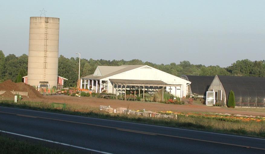
8 Chapter 1 Existing Conditions Virginia Route 20, named the Constitution Route traverses approximately 90 miles through the central part of Virginia in a southwest to northeast direction from Route 15 in central Buckingham County to Route 3 at Wilderness in eastern Orange County. Over most of its length, Route 20 is a rural two-lane highway that not only serves the travel needs of residents, businesses, and visitors; it connects some of Virginia s major historical and cultural resources and is an important scenic asset. There are about 36 miles of Route 20 in Orange County and the Town of Orange. This report documents the study of Route 20 in the eastern portion of Orange County, extending from US Route 522 near Unionville to Route 3 at Wilderness, a distance of approximately 13.4 miles. Route 20 through the study area serves central and eastern Orange County, serving residents and businesses within the corridor as well as connecting population centers in Orange County and the Town of Orange with the Fredericksburg region s Route 3 and I- 95 corridors. Land uses in and near the study corridor are primarily agricultural, with pockets of commercial and residential land uses. The eastern end of the study corridor encompasses a major historic and tourist resource: the National Park Service s Wilderness Battlefield Park, the location of Civil War s Battle of the Wilderness in May of This study incorporates an analysis of traffic growth in the corridor as well as estimates of future travel demands. This important transportation corridor has experienced substantial growth in traffic over the past 10 to 15 years, and this growth is expected to continue. This is particularly true in the historically sensitive eastern portions of the corridor. The Route 20 Corridor Study was performed to develop plans and recommendations to accommodate existing and future travel demands in a safe, efficient, and context-sensitive manner. This study identified transportation concerns and recommendations based on existing conditions (traffic and roadway geometrics), and identified recommendations to address these same concerns for a year 2030 planning horizon. The existing conditions analyses for the corridor study included assessing traffic flow, safety, access, and roadway geometrics. To support these analyses, traffic counts were taken, roadway operations analysis was performed, traffic accident reports were retrieved and analyzed, and field observations were made. In addition, traffic forecasts were developed for the year Study recommendations that address both existing and projected concerns before they become major problems allows for better overall transportation and land use planning. The study, therefore, also seeks to develop a framework for transportation planning in the corridor, and to assist in efforts to preserve the rights-of-way that will be needed to serve existing and future travel demands. 1.1 Roadway Geometry Throughout the study corridor, Route 20 is a two-lane undivided rural roadway with generally 12-foot travel lanes. Shoulder widths generally vary from 1 to 3 feet. Passing 1
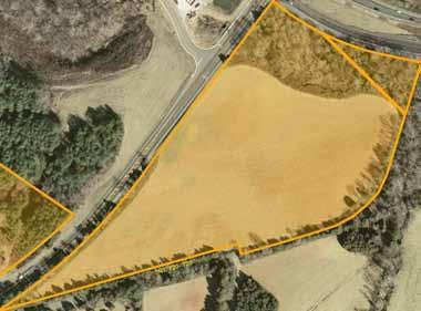
 Zoar Rd (611) Gold Dale Rd (611) Flat Run Rd (601) Parker Rd (611) V 3 Germanna Hwy (3) Spotsylvania County Zachary Taylor Hwy Mine Run Rd (621) Old Plank Rd (621) Independence Rd")
9 V 20 Exhibit 1 Study Corridor Orange County Route 20 Corridor Study Orange County 2 U 522 Pine Stake Rd (621) Lafayette Dr (741) Grasty Gold Mine Rd (692) V 20 Gov. Almond Rd (614) Zoar Rd (611) Gold Dale Rd (611) Flat Run Rd (601) Parker Rd (611) V 3 Germanna Hwy (3) Spotsylvania County Zachary Taylor Hwy Mine Run Rd (621) Old Plank Rd (621) Independence Rd (650) Orange County N Approximate Scale in Miles
10 is not allowed (double yellow line) on approximately 85 percent of Route 20 through the study area. The posted speed limit on most of Route 20 is 55 miles per hour, with speed reductions in several areas due to roadway geometry and/or safety concerns. Traffic signals are located at two intersections with Route 20: US Route 522 (Zachary Taylor Highway), and Virginia Route 3 (Germana Highway). All other intersections on Route 20 are controlled by stop signs on the side streets. With the exception of a westbound right turn lane on Route 20 at its intersection with Route 611, there are currently no turn lanes at the stop-sign controlled intersections in the corridor. Turn lanes have been constructed to serve traffic for the Locust Grove Elementary and Middle Schools in the middle section of the study corridor. Including side roads and driveways, there are 224 access points on Route 20 through the study area. This represents an average of just under 17 access points per mile (combining both directions on Route 20). These access points are shown in Exhibit 2. Exhibit 2 Summary of Access Points Distance Number of access points Number of access points per mile From To (miles) EB WB Total EB WB Total Route 522 Route Route 650 Route 621 East Route 621 East Route 692 East Route 692 East Route Route 611 Route Route 601 Route Totals Note: EB on eastbound lanes; WB on westbound lanes 1.2 Traffic Data Traffic counts were performed on Route 20 in February Forty-eight hour machine counts were performed on three segments of Route 20 and at four locations on side roads off of Route 20. These counts were performed on weekdays (excluding Monday mornings and Friday afternoons) and included classification of vehicles by type (i.e., car and truck). The locations for these 48-hour machine counts, as well as the 24-hour volumes at each location are summarized in Exhibit 3. For all locations in the corridor, the highest daily volumes occurred between the hours of 4:00 and 6:00 p.m. The morning peak period was generally between 7:00 and 9:00 a.m. Traffic on Route 20 itself does exhibit characteristics of commuter flows, with uneven directional flows during peak hours on both the eastern and western portions of the roadway. For the eastern end near Wilderness, peak traffic flows are eastbound in the morning hours heading towards Route 3 and Fredericksburg, with reverse directionality in the evening. Peaking is even more pronounced for the western portion of the study corridor near Unionville, with 74 of all morning peak traffic heading westbound towards the Town of 3
11 Orange and 71 percent of all evening traffic heading eastbound away from the Town of Orange. 24- Hour Traffic Exhibit 3 Summary of Segment Counts AM Peak Hour Volumes PM Peak Hour Volumes East/ West/ East/ West/ North- South- North- Southbound bound bound bound Percent Trucks/Buses Single Unit Multi- Unit Count Location Route 20 between Route 741 West and 7,159 (26%) (74%) (71%) (29%) Route 741 East 4.0% 4.3% Route 20 at Mine Run (between Route 740 7,244 (58%) (42%) (50%) (50%) and Route 729) 7.9% 5.9% Route 20 between Route 611 and Route 9,156 (60%) (40%) (43%) (57%) % 6.1% Route 522 South of ,579 Route 20 (56%) (44%) (43%) (57%) 6.7% 5.1% Route 621 South of ,173 Route 20 (69%) (49%) (50%) (50%) 10.4% 6.5% Route 611 South of ,585 Route 20 (58%) (31%) (36%) (64%) 8.1% 3.8% Route 3 South of ,174 Route 20 (43%) (42%) (35%) (65%) 11.9% 2.5% Notes: The percent of traffic traveling in each direction is shown in parenthesis. Multi-unit trucks are tractor trailers. Intersection turning movement counts were performed at six locations in the corridor. These counts were also conducted in February The counts were conducted on weekdays between the hours of 6:30 and 9:00 a.m. and 4:00 and 6:30 p.m. at the following locations: A. Route 20 at Route 522 (Zachary Taylor Highway) B. Route 20 at Route 650 (Independence Road) C. Route 20 at Route 621 South (Mine Run Road) D. Route 20 at Route 611 (Zoar Road/Gold Dale Road) E. Route 20 at Route 601 (Flat Run Road) F. Route 20 at Route 3 (Germana Highway) Peak hour turning movements for the a.m. and p.m. peak hour are shown in Exhibits 4 and 5, respectively. 1.3 Safety Analysis Roadway safety in the study corridor was assessed based on an analysis of vehicle crash records for the three-year period from January 2002 through December There were a total of 123 vehicular crashes during the three year period from January 2002 through 4
12
13
14 December 2004, with the number of crashes remaining relatively constant between 2002 and 2003 (37 in 2002, 36 in 2003). Between 2003 and 2004, however, there was an increase in crashes of approximately 10 percent (to 50 crashes). The analysis of accidents included assessing the total number of accidents in any calendar year and identifying trends in the number and/or types of accidents at various locations. Locations with high numbers of accidents relative to the entire study corridor were analyzed in conjunction with field investigation to determine potential causes and recommended solutions. The analysis was also supplemented by field observations of traffic safety and by input from the general public, Orange County officials, and VDOT. For comparison with similar roadway facilities across the Commonwealth, accident rates were also calculated based on both total accidents per 100 million vehicle miles (MVM) and for equivalent property damage only (PDO) accidents per 100 million vehicle miles. Accident rates for intersections are based on the number of accidents as compared to the total number of vehicles that enter the intersection. The calculation compares annual accidents to annual entering vehicles (measured in millions). For roadway segments, the calculation compares total annual accidents to total vehicle miles (number of annual vehicles times the length of the segment in miles). The increased severity and cost associated with accidents involving injuries or fatalities is accounted for by calculating the PDO equivalent. Standard methodologies used by VDOT factor a fatal accident by 12, an injury accident by 3, and a PDO accident by 1 to calculate PDO equivalents. For the entire study corridor, there were approximately 108 accidents per 100 million vehicle miles and 230 equivalent PDO accidents per 100 million vehicle miles. This accident rate is less than average within the Commonwealth. In 2000, the average crash rate on Virginia primary arterials was 157 per 100 million vehicle miles. Additional corridor-wide accident statistics are shown in Exhibit 6. Exhibit 6 Corridor-Wide Accident Summary Number of Category Attribute Accidents Percent Total accidents over three years 123 Year Breakdown % % % Accident Type Rear-End 43 35% Angle % Head-On 3 2.4% Sideswipe % Fixed Object 32 26% Other 5 4.1% Time of Day Daylight % Dark % Dawn or Dusk 4 3.3% 7
15 Category Exhibit 6 Corridor-Wide Accident Summary Number of Attribute Accidents Percent Crash Severity Property Damage Only % Injury % Fatality 4 3.3% Exhibits 7 through 10 show accident statistics by segment and intersection. Exhibit 11 summarizes the accidents that occurred in the corridor by VDOT-designated milepost. This graphic sums accidents by half-mile segment centered at every 0.1-mile interval on Route 20. While this results in accidents being counted more than once (the reader is cautioned not to sum all of the accidents in this graph as it will overestimate total accidents), this graphic is useful in identifying geographically where accidents are occurring. Exhibit 11 also shows both the raw number of crashes (shown with the blue line) as well as the PDO-equivalent number of crashes (shown with the red line). As noted above, the PDO-equivalent factors crashes by their severity, with a fatal crash using a factor of 12, an injury crash using a factor of 3, and a PDO crash using a factor of 1. The result provides a composite measure of the relative severity of crashes throughout the study corridor. Exhibits 7 through 10 and Exhibit 11 indicate that, relative to the study corridor as a whole, those locations with potential safety concerns include the following: Intersection and vicinity of Route 20 and Route 650 (Independence Road) Intersection and vicinity of Route 20 and Route 621 South (Mine Run Road) Portion of Route 20 east of Route 692 (Burr Hill Road/Grasty Gold Mine Road) Intersection and vicinity of Route 20 and Route 611 (Zoar Road/Gold Dale Road) Intersection and vicinity of Route 20 and Route 601 (Flat Run Road) Exhibit 7 Accident Summary by Year Location Accidents By Year Type From To All Years Intersection At Route Segment Route 522 Route 619/ Intersection At Route Segment Route 650 Route 621 East Intersection At Route 621 South Segment Route 621 South Route Intersection At Route Segment Route 692 Route Intersection At Route Segment Route 611 Route Intersection At Route Segment Route 601 Route Intersection At Route TOTALS
16 Exhibit 8 Accident Summary by Type Accident Type Location Type From To Rear- End Angle Head- On Sideswipe Fixed Object Other Intersection At Route Segment Route 522 Route Intersection At Route Segment Route 650 Route 621 East Intersection At Route 621 South Segment Route 621 South Route Intersection At Route Segment Route 692 Route Intersection At Route Segment Route 611 Route Intersection At Route Segment Route 601 Route Intersection At Route TOTALS Exhibit 9 Accident Summary by Light Conditions and Severity Time of Day Severity Location Type From To Daylight Dark Dawn/ Dusk Property Damage Only Intersection At Route Segment Route 522 Route Intersection At Route Segment Route 650 Route 621 East Intersection At Route 621 South Segment Route 621 South Route Intersection At Route Segment Route 692 Route Intersection At Route Segment Route 611 Route Intersection At Route Segment Route 601 Route Intersection At Route TOTALS Injury Fatal 9
17 Exhibit 10 Accident Rates Accidents per Million Vehicles* Equivalent Property Damage Only Accidents per Million Vehicles * Location Type From To Intersection At Route Segment Route 522 Route Intersection At Route Segment Route 650 Route 621 East Intersection At Route 621 South Segment Route 621 South Route Intersection At Route Segment Route 692 Route Intersection At Route Segment Route 611 Route Intersection At Route Segment Route 601 Route Intersection At Route * -- For segments, rate is per 100 million vehicle miles traveled (MVMT). For intersections, rate is per 100 million entering vehicles (MEV). 10
18 V 20 Exhibit 11 Location of Crashes ( ) Orange County Route 20 Corridor Study 11 Number of Crashes Along 0.5-Mile Segment Route 741 West Lafayette Dr US Route 522 Route 650 Independence Rd Route 621 East Mine Run Road Route 692 West Grasty Gold Mine Rd Route 729 Tannery Road Route 611 Gold Dale/ Zoar Rd Route 601 Flat Run Road Route 3 Plank Road Notes: The blue line on this chart shows the number of motor vehicle crashes along a 0.5 mile segment of Route 20 centered on a particular milepost. The red line shows the property-damage equivalent number of crashes along 0.5 mile segments. The red line provides a measure of the relative severity of crashes (see text for additional discussion of this concept). Note that for both data sets, the values are for 0.5 mile segments, but are shown every 0.1 mile. Crashes, therefore, are shown in multiple segments VDOT-Designated Milepost
19 1.4 Roadway Operations Analyses Traffic operations in the study corridor were analyzed using the concept of levels of service. The analysis grades traffic operations as a level of service rating from A to F, with A representing excellent traffic flow with minimal delays and F representing failure in traffic operations and very long delays. For most areas in the state, including the section of Route 20 examined in this study, VDOT rates levels of service A, B, or C as acceptable and levels of service D, E, or F as unacceptable. The level of service analysis using grades A through F was used for all the intersections in the study corridor. As shown in Exhibit 12, all of the roadway segments analyzed operate at level of service A, B, or C for existing conditions with the exception of Route 20 between Route 611 and Route 601, which operates at level D during the AM peak hours. The intersection of Route 20 at Route 611 operates at an unacceptable level of service D in the AM peak hours as shown in Exhibit 13. Exhibit 12 Summary of Segment Level of Service (Existing Conditions) 24-Hour AM Peak Hour Traffic Level of Service PM Peak Hour Level of Service Segment Route 20 between Route 741 West and Route 741 East 7,159 C C Route 20 at Mine Run (between Route 740 and Route 729) 7,244 C C Route 20 between Route 611 and Route 601 9,156 D C Route 522 South of Route 20 3,579 B B Route 621 South of Route 20 2,173 A A Route 611 South of Route 20 1,585 A A Route 3 South of Route 20 20,174 B B Exhibit 13 Summary of Intersection Level of Service (Existing Conditions) 2006 Intersection of Route 20 with: AM Peak PM Peak Route 20 at Route 522 A A Route 20 at Route 650 B B Route 20 at Route 621 C C Route 20 at Route 611 D C Route 20 at Route 601 C C Route 20 at Route 3 A A 12
20 1.5 Public Participation and Input The traffic engineering analysis described in this chapter provides an objective and quantitative assessment of transportation operations and safety in the study corridor. Some transportation concerns do not become apparent through engineering analyses, however, and are best identified by speaking with those who live, work, and/or travel the corridor. To collect this important input, public meetings were held in the study corridor on February 22, 2006 and March 29, Approximately 65 people attended the public meetings; several others provided comments either by or telephone. The public meetings provided a forum for questions to be asked and answered and for comments to be taken. At both public meetings, significant portions of the discussion time were spent in answering questions about the study. Questions generally covered the following areas (brief information on responses, where appropriate, is included in parentheses): Study process, as well as how projects proceed through the overall transportation planning process Traffic forecasting process and assumptions (described in this report) Feasibility of decreasing speed limits and increasing enforcement (assessed as part of the development of study recommendations) Availability of data on use of Route 20 by county and non-county residents (origin-destination surveys were not performed as part of this study) Availability of data on number of crashes that involve county and non-county residents (this type of breakdown is not available from the crash data sets) Comments received at the meetings are summarized below. In general, safety was cited frequently as a major concern. It seems like adding turn lanes would be the best solution There are sight distance issues at Route 611 (from signs adjacent to the roadway; these block the view for some types of vehicles and not others) Widening will just bring more traffic (divert from other roads) and encourage more growth Concern that widening would not really improve the roadway s safety The lack of shoulders on Route 20 is an area of concern Should definitely not widen Route 20 through the Wilderness Battlefield area (it really wouldn t be a problem if we just leave the 3 miles through the Battlefield as two lanes) Consider lowering the speed limits Enforce speed limits more thoroughly and consistently There are more crashes than are actually reported, so the crash analysis probably understates some of the safety issues The traffic forecasts are probably low, perhaps by a large margin Widening Route 20 is an economic development issue; younger county residents don t want to have to travel miles for work The intersection at Route 601 near the Wilderness Library is a problem area 13
21 o the northbound lane has a hill which can obstruct oncoming traffic o traffic on Route 601 has greatly increased since the back entrance to Lake of the Woods has been open o Route 601 is used extensively at a cut-through to Route 3 going towards Culpeper o Suggest that a speed reduction to 45 mph with blinking 45 mph signs should be considered The intersection at Route 611 near the Exxon station (Market at Locust Grove) is also a problem area o Concern about how traffic from the new shopping center will safely access Route 20 o Need to strongly consider a traffic light at this location All of these comments were considered in developing and/or revising the recommendations described in Chapter 3 of this report. 14
22 Chapter 2 Year 2030 Traffic Forecasts and Operations The transportation recommendations developed for this study are intended to accommodate both existing travel demands and demands to the year Traffic forecasts for 2030 and analysis of 2030 traffic operations were used to identify future needs and to ensure that the proposed transportation recommendations would adequately and safely accommodate future demand Traffic Forecasts Year 2030 traffic forecasts for this study are based on historic traffic trends along with the traffic expected to be generated by several planned development projects in the corridor. To calculate expected growth in traffic between 2006 and 2030, historic traffic counts collected by VDOT were tabulated along with the 2006 traffic counts performed for this study. Two scenarios were developed, one projecting moderate growth and the second projecting low growth. Based on historic trends, the following annual growth rates were used to forecast traffic to the year 2030: Moderate Growth Scenario o 1.3 percent for the western portion of the study corridor between Route 522 and Route 650 o 1.7 percent for the middle portion of the study corridor between Route 650 and Route 611 o 3.8 percent for the eastern portion of the study corridor between Route 611 and Route 3 Low Growth Scenario o 0.9 percent for the western portion of the study corridor between Route 522 and Route 650 o 1.2 percent for the middle portion of the study corridor between Route 650 and Route 611 o 2.6 percent for the eastern portion of the study corridor between Route 611 and Route 3 As is often typical for studies of this type, the growth rates were not compounded but rather multiplied. By not compounding, the growth rate is effectively a constant volume (rather than a constant percentage) per year. Expected traffic volumes and resulting levels of service for roadway segments on Route 20 are shown in Exhibit 14. In the moderate growth scenario, traffic volumes on Route 20 are expected to be between 9,400 and 17,600 vehicles per day in the year The low growth scenario projects that volumes on Route 20 will range between 8,700 and 14,900 vehicles per day. Exhibit 15 illustrates graphically the expected growth in traffic volume as well as the range of traffic volumes where traffic engineers expect the capacity of a two-lane rural roadway such as Route 20 to be exceeded. The band shown in Exhibit 15 shows the level 15


 10,192 D D 9,258 D C Route 20 between Route 611 and")


23 of service D to E range when traffic volumes enter or exceed the range highlighted by this band, motorists can expect significant delays resulting from traffic congestion. Exhibit 14 Summary of Segment Volumes and Level of Service (Year 2030) Moderate Growth Scenario Low Growth Scenario 24-Hour AM PM 24-Hour AM Traffic LOS LOS Traffic LOS Segment Route 20 between Route 741 West and Route 741 East 9,464 D D 8,734 D C Route 20 at Mine Run (between Route 740 and Route 729) 10,192 D D 9,258 D C Route 20 between Route 611 and Route ,561 E E 14,906 E E Route 522 South of Route 20 4,731 C B 4,366 C B Route 621 South of Route 20 3,057 B B 2,777 B B Route 611 South of Route 20 3,040 B B 2,580 A B Route 3 South of Route 20 38,694 E E 32,843 D D AM LOS = AM peak hour level of service; PM LOS = PM peak hour level of service PM LOS Exhibit 15 Chart of Existing and Projected Traffic Volumes 16
24 Peak hour intersection turning movement volumes for the year 2030 are shown in Exhibits 16 and 17 for the moderate growth scenario, and Exhibits 18 and 19 for the low growth scenario. 2.2 Year 2030 No-Build Traffic Operations The No-Build scenario refers to the situation that would occur if no major improvements, only routine maintenance, were made in the study corridor between now and With increased travel demands and no major improvements, traffic operations and safety in the Route 20 corridor are expected to deteriorate. As shown in Exhibits 14 and 15 on the previous page, regardless of the scenario used, the two-lane portions of Route 20 in most parts of the study corridor would operate at inadequate levels of service by the year 2030 (levels of service D and E). One significant effect of this increased traffic and congestion is substantial delays for motorists turning onto Route 20 from side streets. While inadequate level of service does not necessarily indicate that a traffic signal is warranted (a separate traffic signal warrant analysis is required for signal installation), major delays are indicative of both the potential for signalization and of decreased safety as motorists sometimes take greater risks when frustrated with delays. Exhibit 20 shows the results of the intersection level of service analysis for As this table, shows, 4 of the 6 intersections analyzed are expected to operate at unacceptable levels of service by The highest levels of delay are expected at the Route 20 intersections with Route 611 and Route
25
26
27
28
29 Exhibit 20 Intersection Peak Hour Level of Service (2030) 2030 Moderate Growth 2030 Low Growth Intersection of Route 20 with: AM Peak PM Peak AM Peak PM Peak Route 20 at Route 522 B A A A Route 20 at Route 650 C C C C Route 20 at Route 621 F C E C Route 20 at Route 611 F F F E Route 20 at Route 601 F F F F Route 20 at Route 3 D E B D 2.3 Corridor Transportation Issues Chapter 1 of this report describes existing transportation concerns in the study corridor, identified based on engineering analyses as well as input from the general public. The discussion in previous sections of this chapter highlights that these concerns will be exacerbated by the year 2030 as traffic volumes increase. Exhibit 21 below summarizes some of these existing and projected transportation issues and concerns. Improvements to address these concerns are described in the next chapter. Exhibit 21 Summary of Corridor Transportation Issues Location Transportation Issues Route 20 at Route 522 Accommodating school bus traffic (Zachary Taylor Delays caused by lack of turn lanes Highway) Route 20 at Route 650 Substandard intersection geometrics (Independence Road) Route 20 between Route 650 and Route 621 South Route 20 at and near Route 621 South (Mine Run Road) Route 20 at Route 611 (Zoar Road/Gold Dale Road) Route 20 at Route 601 (Flat Run Road) Route 20 between Route 601 and Route 3 Route 20 at Route 3 (Germana Highway) Safety concerns Narrow shoulders Safety concerns: high number of rear-end crashes suggests need for turn lanes Inadequate levels of service by 2030 Safety concerns and existing capacity concerns: need for turn lanes Anticipated to operate at level of service F in 2030 Commercial development at this location, ensuring continued safe access to this development Safety concerns and existing capacity concerns: need for turn lanes Hill on northbound lane impinges on sight distance Anticipated to operate at level of service F in 2030 Anticipated high level of travel demand in 2030 Historic resources Northbound left turn lane needs to be extended Anticipated to operate at level of service E in
30 Location Overall Exhibit 21 Summary of Corridor Transportation Issues Transportation Issues Lack of shoulders Increased travel demands anticipated to create congestion High number of access points suggests value of plans to consolidate existing access points and control number of new access points Need to control growth through combination of land use and transportation measures Need for increased levels of speed enforcement 23
31 Chapter 3 Study Recommendations As described in previous chapters, this study has identified both existing and future transportation problems in the Route 20 corridor. These concerns were confirmed and reiterated by those who attended the public meetings that were held in the corridor. Meeting participants also supported the need for proactive transportation planning in the corridor to address existing needs and to plan for future improvements. Effective transportation planning in this corridor will provide Orange County, VDOT, and local land-owners with a blueprint for a safe and efficient Route 20. The recommendations of this study fall into three broad categories. The first includes improvements to intersections to improve operations and safety. These improvements are generally to add turn lanes at key locations. The second category of improvement relates to the capacity of Route 20 itself. The traffic forecasts developed by this study indicate a long-term need for widening most or all of Route 20 through the study area by the year The need for widening is based on both a moderate growth scenario (the most realistic scenario) as well as a low-growth scenario. Based on these forecasts, it is prudent for Orange County to preserve rights-of-way in order to minimize the future impacts of any widening projects. Orange County is also a largely rural county with a desire to control growth in order to preserve its rural qualities. It is also prudent, therefore, for the County to implement transportation planning practices in the corridor that support land use measures to control growth. The third broad category of recommendations from this study relate to methods of directing most property access in the corridor to a limited number of well-designed locations (driveways and secondary roads), to making use of parallel secondary roads or parallel circulation roads to provide access to individual parcels, and to requiring setbacks for new structures. These recommendations will provide additional teeth to regulations to discourage strip development and they will preserve the rural look of the corridor by requiring setbacks. Because access points also require the clearing of vegetation to provide for adequate sight distances, controlling the number, location, and design of access points also preserves and enhances the natural landscaping of a corridor. The implementation of these planning recommendations would be through the changes to the Comprehensive Plan, implementation of overlay zoning, and use of this study in terms of guiding the local circulation provisions that accompany any new development. Many of this study s planning recommendations fall under the term access management. Access management is the concept of managing and controlling access in order to preserve the transportation function and safety of a roadway. Access management should also be a key feature of any widening of Route 20. Where it is widened, Route 20 should incorporate a median, as medians provide an important mechanism for limiting and managing access. Limiting of access by controlling the number of driveways and medians promotes safety because it reduces the number of conflict points and reduces the variation in vehicle speeds. Studies have consistently shown that the number of driveways per mile on a roadway is a key indicator of accident frequency. Traffic entering and exiting at driveways, particularly vehicles making left turns, also reduce the 24
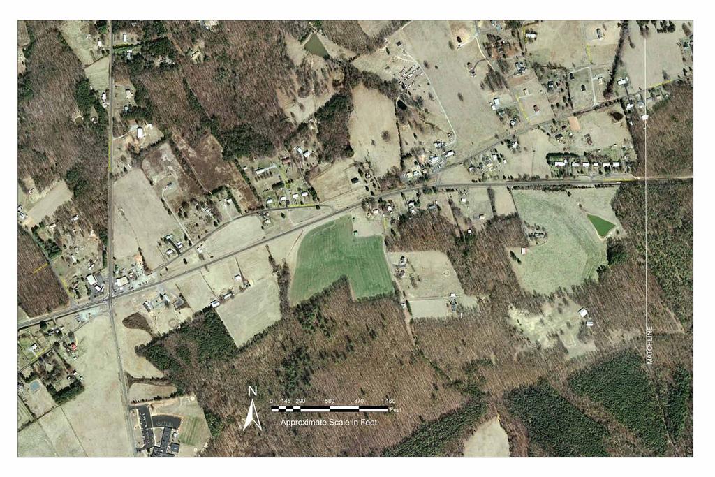
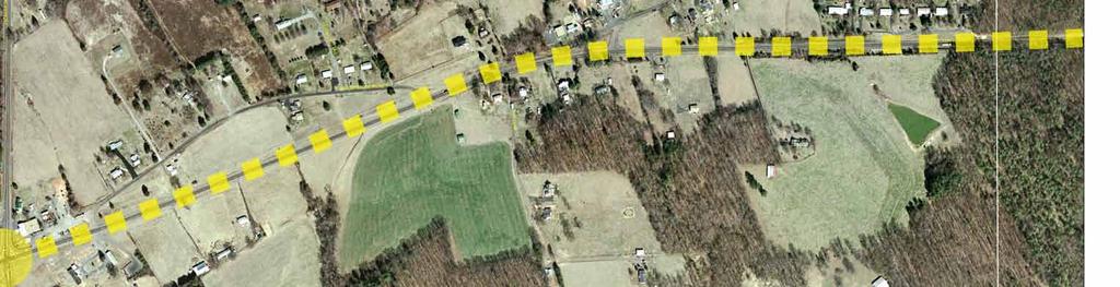
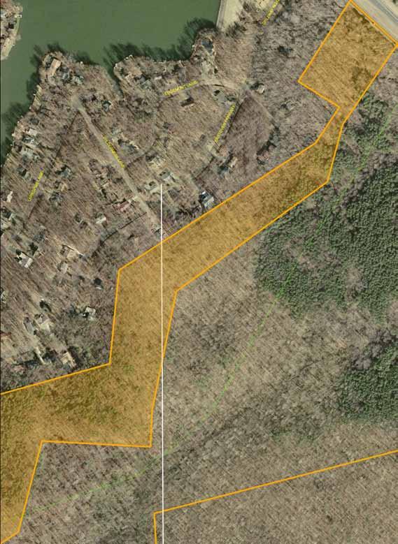
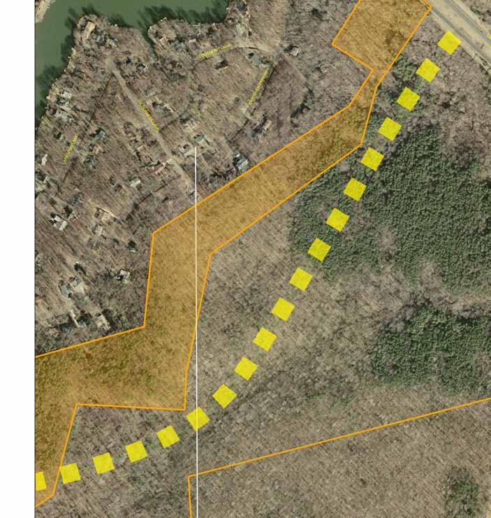
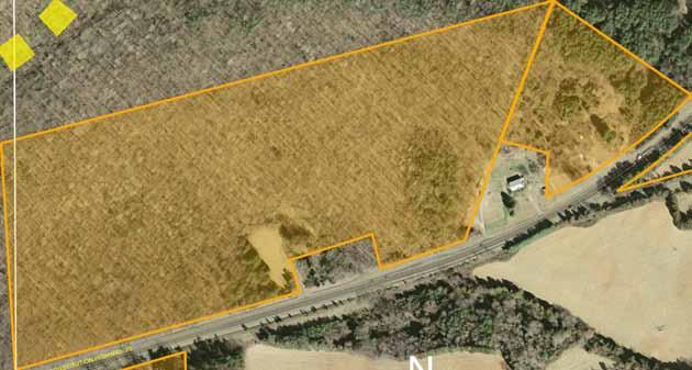
32 flow of traffic. Limiting access will also, therefore, promote long-term smooth traffic flow in the corridor. Pedestrian and bicycle safety is also substantially degraded as the number of entrance points onto a road increases. Finally, limiting access also serves to reduce or eliminate the strip development that extends along a roadway rather than focusing on a limited number of activity nodes. Another key feature of the planning recommendations is the establishment of key access points that are spaced relatively evenly through the corridor. These proposed key access points support a hierarchy of access in the study corridor, which is supportive of both good land use and transportation planning. The key access points are illustrated in Exhibit 22, and are listed below: US Route 522 (Zachary Taylor Highway) Route 650 (Independence Road) Route 621 South (Mine Run Road) Route 692 (Burr Hill Road/Grasty Gold Mine Road) Route 611 (Zoar Road/Gold Dale Road) Route 601 (Flat Run Road) Route 3 (Germana Highway) To the extent possible, access to adjacent properties should seek to access Route 20 at the identified key points (either directly, or indirectly through secondary or parallel road connections). In addition, while Orange County zoning and comprehensive planning foresees much of this corridor as agricultural and other low-density uses, the limited amount of commercial properties in the corridor should be focused on these access nodes. Several of this study s specific roadway recommendations support this concept by shifting existing roadways to come into Route 20 at these key access nodes. Exhibit 22 Proposed Major Access Nodes On Route 20 25
33 This study includes short-, mid-, and long-term recommendations. Short-term improvements are recommended to be implemented within the next 5 years. These improvements include relatively low-cost and low-impact improvements as well as planning actions that Orange County should take within the same five-year timeframe. Mid-term improvements are those that would be implemented within the 5 to 10 year timeframe. These include projects that require some lead time in terms of location and environmental studies, as well as more capital-intensive projects that require some time to accrue funding for construction. Long-term projects are those that would be implemented over a timeframe of 10 years or more. Many long-term recommendations relate to improvements that are contingent on property uses changing. In other words, these recommendations are intended to guide decisions that would be necessary should a property convert to a more intensive use. Improvements such as parallel access roads or shifting entrances should then be part of the re-development. Note that parallel roads are recommended as a planning concept in the Locust Grove area around Route 611. In the sections below, study recommendations are coded by number for each of the timeframes (i.e., Recommendation S1 is the first short-term recommendations). The improvements for all three timeframes are also depicted in Exhibits 24 through 35 using these same improvement codes. 3.1 Short-Term Recommendations The implementation of access management in the Route 20 corridor will require that a planning and regulatory framework be established. Short-term (0 to 5 years) recommendations address this requirement, and incorporate a number of intersection and roadway safety improvements that are relatively low-cost. S1: Adopt changes to the Orange County Comprehensive Plan to provide the foundation for corridor preservation, corridor overlay zoning, and access management in the Route 20 Corridor. Incorporate references to this Route 20 Corridor Management Plan. S2: Begin to implement the access management and local circulation plan by incorporating additional elements into the Corridor Overlay District element of the Orange County Zoning Ordinance. The Corridor Overlay District should extend 1,000 feet on each side of the centerline of Route 20. This will provide Orange County with the mechanism to control the number of access points onto Route 20. The overlay zoning ordinance should: 1. Incorporate minimum frontage requirements commensurate with this state primary highway. This study recommends a minimum parcel frontage of 500 feet for an access point and 800 feet of additional frontage for each additional access point (these requirements were developed based on desirable spacing to accommodate stopping sight distance). 2. Require driveways be located at least 150 feet from the intersections of Route 20 with secondary roads, particularly those roadways identified on page 25 as key access points. 26
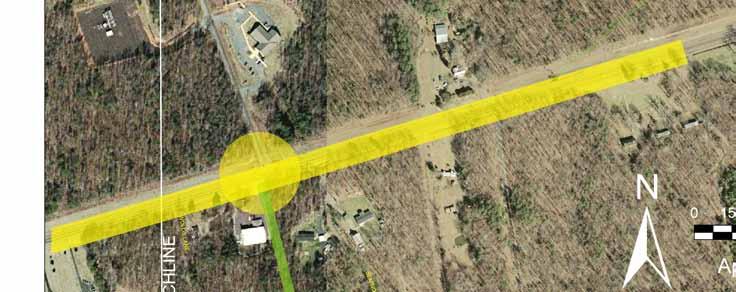
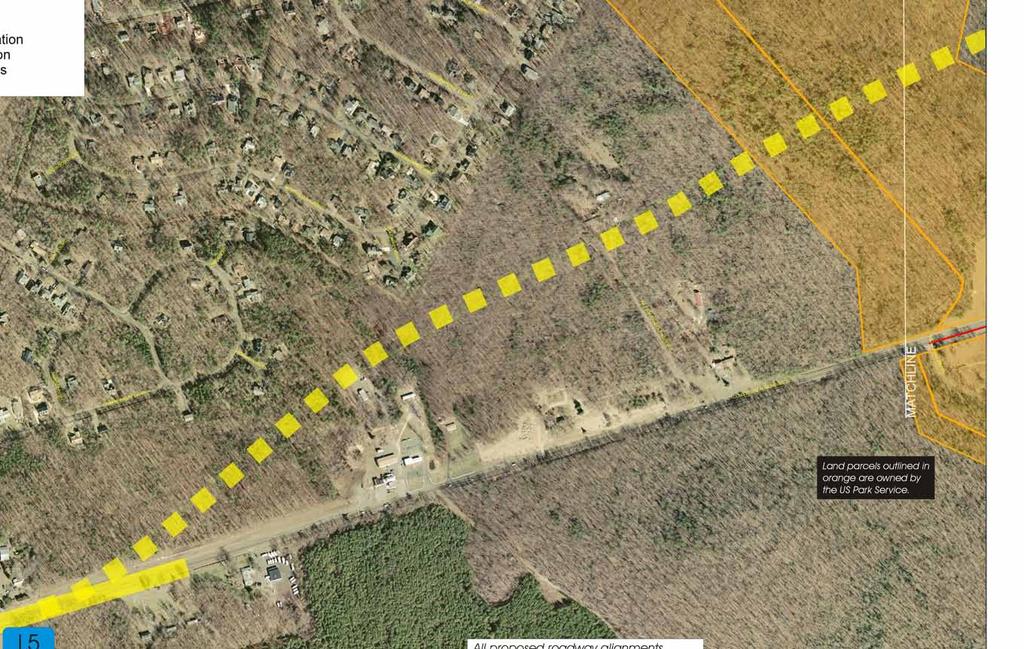
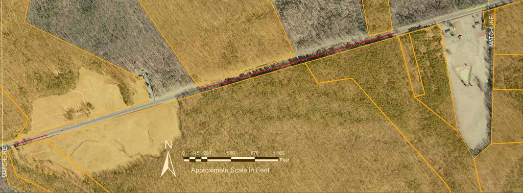
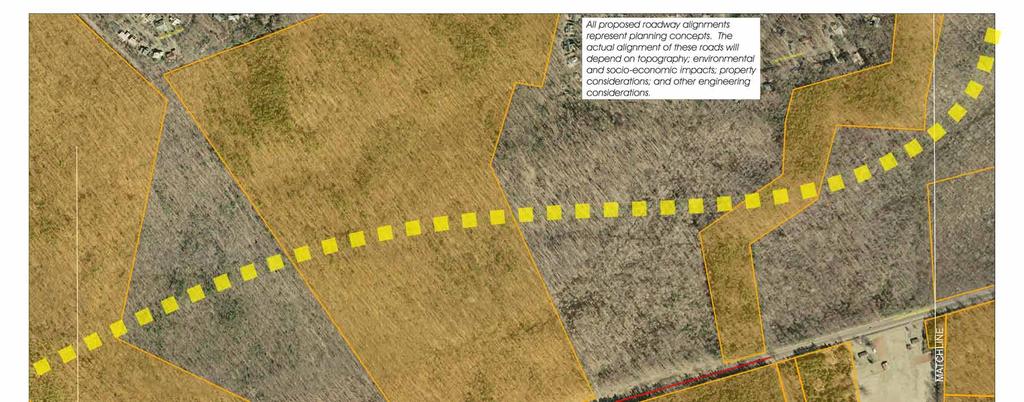
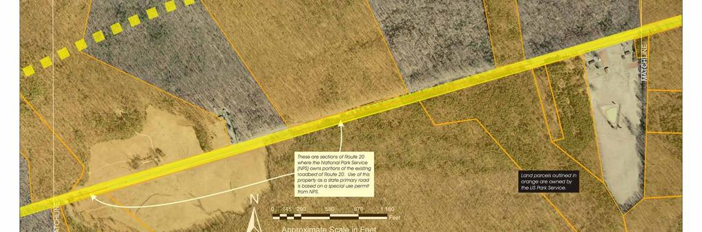
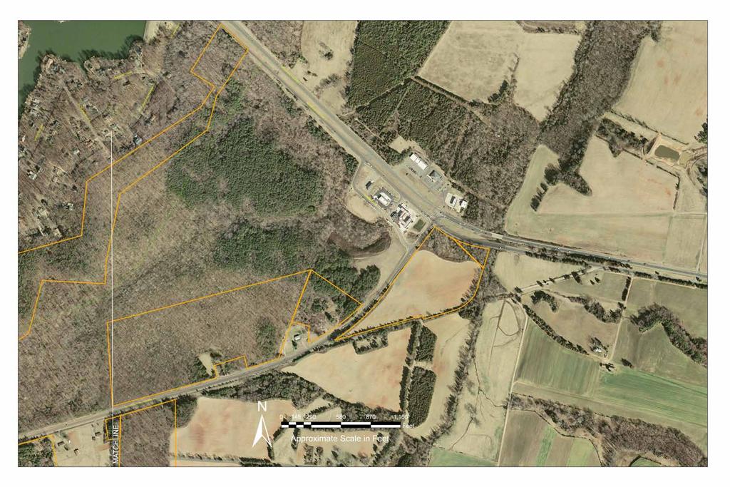
34 3. Provide incentives for shared entrances, inter-parcel access, and/or access via existing or proposed secondary roads, as well as new parallel roads. 4. Promote the design of driveways that come in directly across, rather than offset, from existing driveways on the opposite side of Route Support the construction of the roadway improvements in this study, particularly those that seek to remove intersection offsets (an example in the study corridor of this type of offset occurs at Route 692 Burr Hill Road and Grasty Gold Mine Road). 6. Develop and implement driveway design guidelines that establish the best location for property access as well as measures to enhance the visibility of driveways for motorists. 7. Provide setbacks to ensure right-of-way is available to widen Route 20 at such time that it is deemed necessary. Implementation of access management in the Route 20 Corridor would also include several changes in procedures. These are: 1. New agreements for access onto Route 20 should incorporate language stating that such access is temporary until such time that alternative access via localized internal or parallel roads, or a secondary road, is developed. Orange County will need to coordinate with VDOT to apply these guidelines. Where agreements already exist between VDOT and landowners, both Orange County and VDOT should seek to minimize the impacts that any new access points would have on traffic flow and safety. 2. The goals of the updated Comprehensive Plan, access management, and localized circulation should be integrated into the subdivision, site plan, and negotiation process with landowners and developers. S3: Close western-most entrance of Lafayette Drive (Route 741). S4: Upgrade intersection of Route 20 at Route 611 (Zoar Road/Gold Dale Road); add turn lanes on all approaches and perform warrant analysis for signalization (cost assumes installation of traffic signal). S5: Upgrade intersection of Route 20 at Route 601 (Flat Run Road); add turn lanes on all approaches. S6: Establish Route 20 East Planning Corridor to preserve right-of-way for potential new four-lane alignment of Route 20. This planning corridor would be located north of existing Route 20. The preservation of this corridor would be needed to provide an alternative roadway alignment to widening along existing Route 20 through sensitive historic areas. Continue to coordinate with the National Park Service to refine the alignment for this planning corridor. 27
35 3.2 Mid-Term Recommendations Mid-term improvements are recommended to be implemented in a 5 to 10 year timeframe. M1: Upgrade intersection of Route 20 at Route 522 (Zachary Taylor Highway); add left turn lanes on all approaches and shift intersection of Route 522 at Route 671 (Village Road) south. M2: Relocate intersection of Route 20 at Route 650 (Independence Road) to come in across from the eastern intersection of Route 741 (Lafayette Drive); upgrade this new four-leg intersection. M3: Coordinate with land owners in the area east of existing Route 650 (Independence Road) to improve the definition and design of driveways in this area. M4: Upgrade intersection of Route 20 with Route 621 South (Mine Run Road); add turn lanes on all approaches. M5: Relocate intersection of Route 621 South (Mine Run Road) and Route 742 (Strawberry Hill Road) to come in approximately 300 feet south of Route 20 (across from existing driveway on west side of Mine Run Road). 3.3 Long-Term Recommendations Long-term improvements are anticipated to be constructed within a 10 to 20 year timeframe. L1: Consolidate two entrances of Route 671 (Narrow Gauge Road) onto Route 20 to a single entrance; add turn lanes at this new consolidated entrance. This new consolidated entrance should be located at or just west of the existing Route 671 East intersection (the exact location for this entrance would be determined based on property and site design considerations). L2: Relocate Route 621 North (Pine Stake Road) intersection with Route 20 to come in across from Route 621 South (Mine Run Road); upgrade this new four-leg intersection. L3: Relocate Route 692 South (Grasty Gold Mine Road) to come in across from Route 692 North (Burr Hill Road); upgrade this new four-leg intersection. L4: Construct new parallel roadways in the vicinity of Route 611 to provide for interparcel access within this commercial center; parallel circulation roads should be located 400' to 500' from Route 20 centerline. 28
36 L5: Widen Route 20 to four lanes divided from Route 611 to 0.2 miles east of Route 601. L6: Relocate Wolds Lane to come in across from Route 601 (Flat Run Road); this roadway would be constructed to provide access, if needed, to parcels on the south side of Route 20. L7: Widen Route 20 to four lanes divided from 0.2 miles east of Route 601 to Route 3 (based on further study, a new four-lane divided alignment for Route 20 may be developed). 3.4 Estimated Costs Cost estimates were developed for the physical improvements described in the three previous sections using standard unit costs provided by VDOT. The resulting cost estimates were then reviewed with County and VDOT staff. These costs are in year 2006 dollars. It is important to recognize that the costs are planning-level estimates only and are subject to adjustment following more detailed engineering analysis. Unforeseen environmental impacts can also have a substantial effect on project costs. The estimated costs for each improvement are shown in Exhibit 23. The totals for each timeframe are shown below: Short-term $1.73 million Mid-term $2.49 million Long-term $28.17 million Code S3 S4 S5 S6 Exhibit 23 Estimated Costs for Physical Improvements Estimated Project Description Length (feet) Close western-most entrance of Lafayette Drive (Route 741) Upgrade intersection of Route 20 at Route 611 (Zoar Road/Gold Dale Road); add turn lanes on all approaches and perform warrant analysis for signalization (cost assumes installation of traffic signal) Upgrade intersection of Route 20 at Route 601 (Flat Run Road); add turn lanes on all approaches Establish Route 20 East Planning Corridor to preserve right-of-way for potential new alignment of Route 20 Total Estimated Cost NA $10,000 NA $970,000 NA $750,000 NA NA 29
37 Code M1 M2 M3 M4 M5 Exhibit 23 Estimated Costs for Physical Improvements Description Upgrade intersection of Route 20 at Route 522 (Zachary Taylor Highway); add left turn lanes on all approaches and shift intersection of Route 522 at Route 671 (Village Road) south Relocate intersection of Route 20 at Route 650 (Independence Road) to come in across from the eastern intersection of Route 741 (Lafayette Drive); upgrade this new four-leg intersection Coordinate with land owners in the area east of existing Route 650 (Independence Road) to improve the definition and design of driveways in this area Upgrade intersection of Route 20 with Route 621 South (Mine Run Road); add turn lanes on all approaches Relocate intersection of Route 621 South (Mine Run Road) and Route 742 (Strawberry Hill Road) to come in approximately 300 feet south of Route 20 (across from existing driveway on west side of Mine Run Road) Estimated Project Length (feet) Total Estimated Cost 440 $1,109, $733,000 NA NA NA $500, $150,000 L1 L2 L3 L4 Consolidate two entrances of Route 671 (Narrow Gauge Road) onto Route 20 to a single entrance; add turn lanes at this new consolidated entrance Relocate Route 621 North (Pine Stake Road) intersection with Route 20 to come in across from Route 621 South (Mine Run Road); upgrade this new four-leg intersection Relocate Route 692 South (Grasty Gold Mine Road) to come in across from Route 692 North (Burr Hill Road); upgrade this new four-leg intersection Construct new parallel roadways in the vicinity of Route 611 to provide for inter-parcel access within this commercial center; parallel circulation roads should be located 400' to 500' from Route 20 centerline 300 $500, $717, $600, $1,600,000 30
38 Code L5 L6 L7 Exhibit 23 Estimated Costs for Physical Improvements Description Widen Route 20 to four lanes divided from Route 611 to 0.2 miles east of Route 601 Relocate Wolds Lane to come in across from Route 601 (Flat Run Road); this roadway would be constructed to provide access, if needed, to parcels in this area Widen Route 20 to four lanes divided from 0.2 miles east of Route 601 to Route 3 (based on further study, a new four-lane divided alignment for Route 20 may be developed) Estimated Project Length (feet) Total Estimated Cost $12,554, $292, $11,905, Additional Considerations and Estimated Costs Upgrades to Route 621 As part of this study, consideration was given to upgrading Route 621 (Mine Run Road and Old Plank Road) as an alternative route for traffic traveling to Route 3 towards Fredericksburg. In general, the issue relates to traffic going from the vicinity of Route 20 at Route 621 East to Route 3 at Route 621 (and extending to points further south on Route 3) by one of two paths: Path 1: Via Route 20 to Wilderness and then south on Route 3 (and vice-versa) Path 2: Via Route 621 While travel surveys to quantify the actual amount of traffic taking Path 1 versus Path 2 were beyond the scope of this study, it appears that Path 2 does serve as a viable alternative route for some traffic. Observation, comments from those who travel the corridor on a daily basis, as well as the turning movement counts at Route 20 and Route 621, all support the conclusion that Path 2 is a potential alternative route. For this reason, the study team considered upgrading Route 621 as an alternative to widening Route 20. This concept was not ultimately recommended for the following reasons: 1. Taking into account the relative distance and travel speeds, the travel time on Path 2 is about 20 percent longer than Path 1 (18.5 minutes as compared to 15.3 minutes). Path 2 is also slightly longer in terms of distance (13.5 miles versus 13.3 miles). If Route 20 is relocated to follow the planning corridor described previously as Recommendation S6 (thereby adding 0.4 miles to Path 1), it will continue to be quicker for motorists to use Route 20 rather than Route 621 (15.5 minutes versus 18.5 minutes). 31
39 2. Like Route 20, Route 621 traverses historically sensitive lands and widening it would entail similar levels of potential historic impacts. 3. There is ongoing residential development along Route 621 in Spotsylvania County and the road is increasingly taking on more of a role as a lower-speed residential collector roadway. Changing this road to serve more as a throughtraffic road would run counter to the current character of the roadway and its adjoining land uses. 4. Route 20 is designated a state primary route, while Route 621 is a secondary road. From an overall transportation planning perspective, it is preferable to keep through traffic on primary routes rather than divert it to secondary roads. For these reasons, this study does not recommend that Route 621 be developed as an alternative route for Route 20 traffic. Route 621 between Route 20 and Route 3 is currently substandard in terms of geometrics, however, and increasing traffic demands on this road make it critical that improvements to enhance safety be implemented. This study recommends upgrading Route 621 from Route 20 to the Spotsylvania County line (a distance of 6.5 miles) to meet current standards with 12-foot lanes. The estimated cost for this improvement (also in 2006 dollars) is $9.34 million. Orange County should also coordinate with both Spotsylvania County and the Virginia Department of Transportation to extend the upgrading of Route 621 in Spotsylvania County to its intersection with Route 3. Additional Costs for Widening Route 20 between Route 601 and Route 3 The cost estimates developed for this study are planning-level estimates that are based on statewide averages for similar types of improvements. The cost estimates for widening Route 20 between Route 601 and Route 3 (Recommendation L7) are based on widening the roadway along its existing alignment. As discussed previously, substantial historic impacts may require that Route 20 be relocated along the planning alignment described as Recommendation S6). This alignment will be slightly longer and require larger amounts of rights-of-way as compared to the existing alignment, thereby resulting in increased costs. An additional significant cost for constructing Route 20 on the S6 alignment would be the need for upgrading the dam in Lake of the Woods. This is because the existing dam would not provide for sufficient flood control to ensure that the new alignment of Route 20, which would be closer to Lake of the Woods, would be outside of flood boundaries. Estimates provided by the Lake of the Woods Association indicate that it would cost between $2.5 and $3.0 million to upgrade the dam sufficiently to allow for the S6 alignment to be constructed. This cost would be a required mitigation measure for the new alignment and should be considered as part of the total cost package for this alignment. It is important to emphasize that all estimated costs would be refined as part of the project development process. Detailed environmental impact analyses will be required to develop the most desirable alignments for providing additional capacity for Route 20. Such studies will consider the full range of impacts and costs, including costs to minimize and mitigate the impacts of the upgraded roadway. 32

40

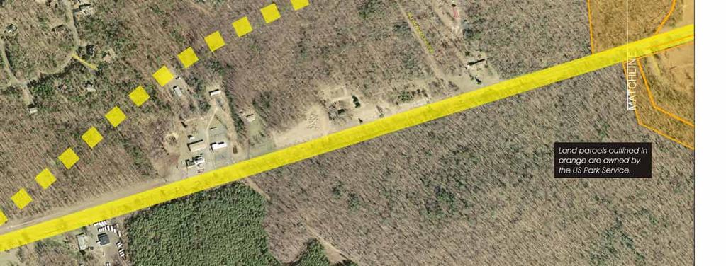
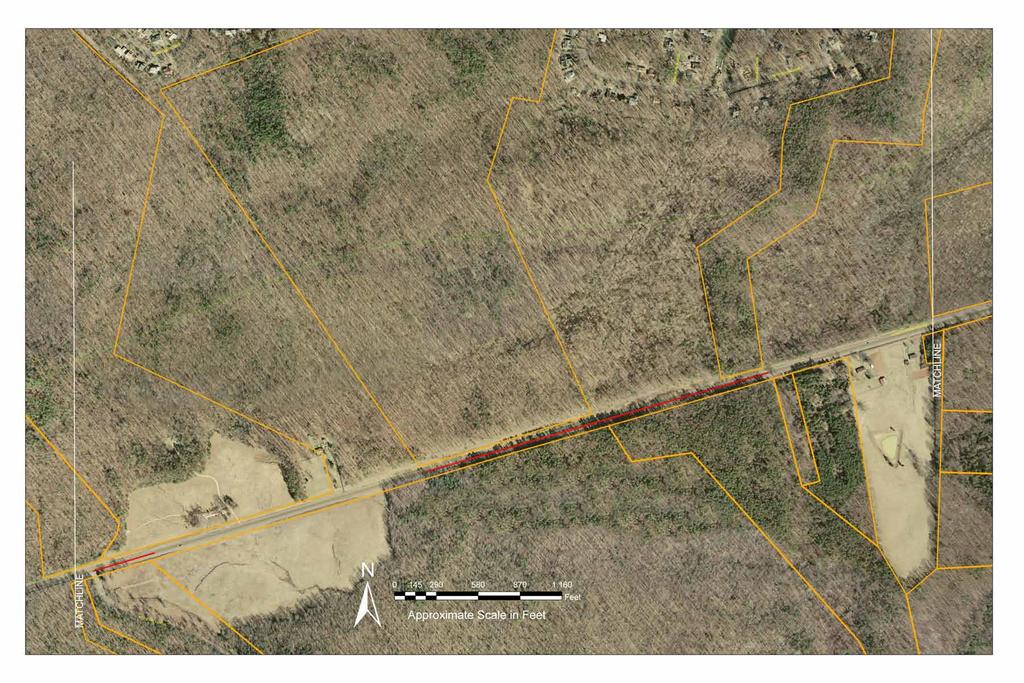
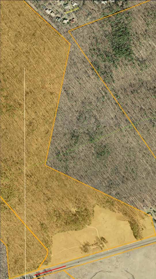
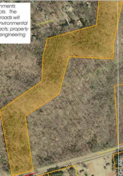
41 M1 Orange County Route 20 Corridor Study Exhibit 25 Improve existing intersection Widen roadway Corridor planning/right-of-way preservation Close existing road or modify connection Proposed new roadways or connections Recommendation number S2 All proposed roadway alignments represent planning concepts. The actual alignment of these roads will depend on topography; environmental and socio-economic impacts; property considerations; and other engineering considerations.


42 M1 Orange County Route 20 Corridor Study Exhibit 26 Improve existing intersection Widen roadway Corridor planning/right-of-way preservation Close existing road or modify connection Proposed new roadways or connections Recommendation number L2 M3 Work with land-owners to improve driveway definition in this area 621 S M2 All proposed roadway alignments represent planning concepts. The actual alignment of these roads will depend on topography; environmental and socio-economic impacts; property considerations; and other engineering considerations.


43 M1 Orange County Route 20 Corridor Study Exhibit 27 Improve existing intersection Widen roadway Corridor planning/right-of-way preservation Close existing road or modify connection Proposed new roadways or connections Recommendation number S2 L2 M4 742 M5 621 All proposed roadway alignments represent planning concepts. The actual alignment of these roads will depend on topography; environmental and socio-economic impacts; property considerations; and other engineering considerations.


44 M1 Orange County Route 20 Corridor Study Exhibit 28 Improve existing intersection Widen roadway Corridor planning/right-of-way preservation Close existing road or modify connection Proposed new roadways or connections Recommendation number 692 L3 S2 All proposed roadway alignments represent planning concepts. The actual alignment of these roads will depend on topography; environmental and socio-economic impacts; property considerations; and other engineering considerations.


45 M1 Orange County Route 20 Corridor Study Exhibit 29 Improve existing intersection Widen roadway Corridor planning/right-of-way preservation Close existing road or modify connection Proposed new roadways or connections Recommendation number 740 S2 All proposed roadway alignments represent planning concepts. The actual alignment of these roads will depend on topography; environmental and socio-economic impacts; property considerations; and other engineering considerations.


46 M1 Orange County Route 20 Corridor Study Exhibit 30 Improve existing intersection Widen roadway Corridor planning/right-of-way preservation Close existing road or modify connection Proposed new roadways or connections Recommendation number S2 All proposed roadway alignments represent planning concepts. The actual alignment of these roads will depend on topography; environmental and socio-economic impacts; property considerations; and other engineering considerations.


47 M1 Orange County Route 20 Corridor Study Exhibit 31 Improve existing intersection Widen roadway Corridor planning/right-of-way preservation Close existing road or modify connection Proposed new roadways or connections Recommendation number L5 611 L4 S4 S2 611 All proposed roadway alignments represent planning concepts. The actual alignment of these roads will depend on topography; environmental and socio-economic impacts; property considerations; and other engineering considerations.


48 M1 Orange County Route 20 Corridor Study Exhibit 32 Improve existing intersection Widen roadway Corridor planning/right-of-way preservation Close existing road or modify connection Proposed new roadways or connections Recommendation number L5 All proposed roadway alignments represent planning concepts. The actual alignment of these roads will depend on topography; environmental and socio-economic impacts; property considerations; and other engineering considerations.


49


50


51
ROUTE 122 CORRIDOR STUDY ---- Bedford County and Bedford City, Virginia
 ROUTE 122 CORRIDOR STUDY ---- Bedford County and Bedford City, Virginia Developed by Region 2000 Regional Commission In cooperation with Bedford County, Virginia City of Bedford, Virginia Virginia Department
A. CONCLUSIONS OF THE FGEIS
 Chapter 11: Traffic and Parking A. CONCLUSIONS OF THE FGEIS The FGEIS found that the Approved Plan will generate a substantial volume of vehicular and pedestrian activity, including an estimated 1,300
FNORTHWEST ARKANSAS WESTERN BELTWAY FEASIBILITY STUDY
 FNORTHWEST ARKANSAS WESTERN BELTWAY FEASIBILITY STUDY EXECUTIVE SUMMARY The 2030 Northwest Arkansas Regional Transportation Plan developed by the Northwest Arkansas Regional Planning Commission (NWARPC)
Lake Erie Commerce Center Traffic Analysis
 LOCATION: East of NYS Route 5 at Bayview Road Town of Hamburg Erie County, New York PREPARED BY: Wendel Companies 140 John James Audubon Parkway Suite 200 Amherst, New York 14228 January 2012 i ii Table
MEMORANDUM. Lynn Hayes LSA Associates, Inc.
 MEMORANDUM To: Lynn Hayes LSA Associates, Inc. Date: May 5, 217 From: Zawwar Saiyed, P.E., Senior Transportation Engineer Justin Tucker, Transportation Engineer I Linscott, Law & Greenspan, Engineers LLG
Rappahannock-Rapidan Regional Commission 2010 Travel Time Survey
 Rappahannock-Rapidan Regional Commission 2010 Travel Time Survey Rappahannock Rapidan Regional Commission 420 Southridge Pkwy. Suite 106 Culpeper, VA 22701 June 16, 2010 Introduction Travel time, or the
4. Safety Concerns Potential Short and Medium-Term Improvements
 NH Route 104 Access Management Study Page 19 4. Safety Concerns Potential Short and Medium-Term Improvements Potential safety improvement strategies are listed by priority based on field observations by
Other Principle Arterials Minor Arterial Major Collector Minor Collector Local
 CHAPTER 10 TRANSPORTATION Introduction The system of public roads in East Pikeland Township is decidedly rural in character. Since the 1984, the road network has remained much the same, with the addition
Arlington County Board Meeting Project Briefing. October 20, 2015
 Arlington County Board Meeting Project Briefing October 20, 2015 Project Map 2 Project Context Only Interstate in the Country limited to HOV only traffic during rush hours Stoplight at the end of I-66
1.2 Corridor History and Current Characteristics
 SECTION 1 Description and Background of Study Area 1.1 Introduction This preliminary engineering report was prepared for the Alaska Department of Transportation and Public Facilities (ADOT&PF). It is part
McLean Citizens Association Transportation Committee Project Briefing
 McLean Citizens Association Transportation Committee Project Briefing November 10, 2015 Project Map 2 Project Context Only Interstate in the Country limited to HOV only traffic during rush hours Stoplight
Interstate 90 and Mercer Island Mobility Study APRIL Commissioned by. Prepared by
 Interstate 90 and Mercer Island Mobility Study APRIL 2017 Commissioned by Prepared by Interstate 90 and Mercer Island Mobility Study Commissioned by: Sound Transit Prepared by: April 2017 Contents Section
5.1 Traffic and Transportation
 5.1 When it opens in 2009, the Bellevue Nickel Improvement Project will increase the number of vehicles able to travel through the study area, improve travel speeds, and improve safety by reducing the
NORTH FRASER PERIMETER ROAD WEST CORRIDOR DEFINITION STUDY
 NORTH FRASER PERIMETER ROAD WEST CORRIDOR DEFINITION STUDY MAY 2011 SW1132SWD NORTH FRASER PERIMETER ROAD WEST CORRIDOR DEFINITION STUDY TABLE OF CONTENTS 1.0 INTRODUCTION... 1 2.0 CURRENT TRAVEL PATTERNS
2008 DEKALB COUNTY TRANSPORTATION PLAN (UPDATE)
") 2008 DEKALB COUNTY TRANSPORTATION PLAN (UPDATE) TABLE OF CONTENTS Introduction 1 Transportation Planning Activities 2 Identification of Problem Areas and Recommended Solutions 7 DeKalb County Projects
2008 DEKALB COUNTY TRANSPORTATION PLAN (UPDATE) TABLE OF CONTENTS Introduction 1 Transportation Planning Activities 2 Identification of Problem Areas and Recommended Solutions 7 DeKalb County Projects
PURPOSE AND NEED (CONCURRENCE POINT 1) NEW CANADA ROAD PROJECT FROM STATE ROUTE 1 (U.S. HIGHWAY 70) TO U.S. INTERSTATE 40
 NEW CANADA ROAD PROJECT FROM STATE ROUTE 1 (U.S. HIGHWAY 70) TO U.S. INTERSTATE 40") PURPOSE AND NEED (CONCURRENCE POINT 1) NEW CANADA ROAD PROJECT FROM STATE ROUTE 1 (U.S. HIGHWAY 70) TO U.S. INTERSTATE 40 Project Description The primary purpose of this project is to improve the major
PURPOSE AND NEED (CONCURRENCE POINT 1) NEW CANADA ROAD PROJECT FROM STATE ROUTE 1 (U.S. HIGHWAY 70) TO U.S. INTERSTATE 40 Project Description The primary purpose of this project is to improve the major
Washington St. & Ash Coulee Dr./43 rd Ave Intersection Study
 430 IACC Building Fargo, ND 58105 Tel 701-231-8058 Fax 701-231-1945 www.ugpti.org www.atacenter.org Washington St. & Ash Coulee Dr./43 rd Ave Intersection Study Final Report April 2007 Prepared for: City
2006 WEEKDAY TRAFFIC PROFILE. June 15, 2007
 June 15, 2007 Mr. Gary Stobb, P.E. Director of Planning/Operations Harris County Toll Road Authority 330 Meadowfern, Suite 200 Houston, TX 77067 Re: Westpark Tollway Value Pricing Analysis Dear Mr. Stobb:
HAMPTON ROADS CROSSINGS PATRIOTS CROSSING AND HRBT
 HRTPO Board Meeting March 21, 2013 Agenda ITEM #9: HAMPTON ROADS CROSSINGS PATRIOTS CROSSING AND HRBT Congestion at the Hampton Roads Bridge-Tunnel (HRBT) on I-64 has long been identified as a problem
Alternatives Analysis City of Newport Beach Sunset Ridge Park Project December 14, 2011
 Alternatives Analysis City of Newport Beach Sunset Ridge Park Project December 14, 2011 Alternatives Analysis for Vehicular Access: This report supplements the project s certified EIR s Alternatives Analysis.
HOV LANE PERFORMANCE MONITORING: 2000 REPORT EXECUTIVE SUMMARY
 Final Report Research Project Agreement No. T1803, Task 4 HOV Monitoring V HOV LANE PERFORMANCE MONITORING: 2000 REPORT EXECUTIVE SUMMARY by Jennifer Nee TRAC Research Engineer John Ishimaru TRAC Senior
B. Congestion Trends. Congestion Trends
 B. Congestion Trends Congestion Trends There are two types of congestion that impact mobility: recurring and non-recurring congestion. Recurring congestion is related to segments of roadway that are over
Section 106 Update Memo #1 Attachment D. Traffic Diversion & APE Expansion Methodology & Maps
 Section 106 Update Memo #1 Attachment D Traffic Diversion & APE Expansion Methodology & Maps I-65/I-70 North Split Interchange Reconstruction Project (Des. Nos. 1592385 & 1600808) Traffic Diversion and
Frequently Asked Questions on the Route 29 Solutions Improvements Projects
 Frequently Asked Questions on the Route 29 Solutions Improvements Projects Background What are the Route 29 Solutions improvement projects? These projects include the Route 29/250 Interchange ( Best Buy
Watts St westbound thru
 Executive Summary At the request of the Hudson Square Business Improvement District, Sam Schwartz Engineering, DPC (Sam Schwartz) has completed a technical analysis of various congestion pricing and/or
FHWA P/N Guidelines. Corridor Relationship. Highway 22 Segment 1 - US 169 to CSAH 2 Relevance / Documentation of Need
 Highway 22 Segment 1 - US 169 to CSAH 2 Vehicle Mobility Congestion Intersection Congestion Existing Conditions - Based on Highway Capacity Manual methodology, corridor level of service is currently LOS
I-66 Inside the Beltway Feasibility Study
 I-66 Inside the Beltway Feasibility Study Feasibility Study Study Process Context Sensitive Dialogues Corridor Assessments / Data Collection Problem Statement Refinement Concept Development Concept Evaluation
November 11, 2009 BY . Planning and Growth Management Department 110 Laurier Avenue West, 4 th Floor Ottawa, Ontario K1P 1J1. Dear Mr.
 November 11, 2009 Planning and Growth Management Department 110 Laurier Avenue West, 4 th Floor Ottawa, Ontario K1P 1J1 BY E-MAIL Attention: Mr. Don Herweyer Dear Mr. Herweyer: Reference: Abbott-Fernbank
LUDWIG RD. SUBDIVISION PROJECT TRAFFIC IMPACT ANALYSIS
 LUDWIG RD. SUBDIVISION PROJECT TRAFFIC IMPACT ANALYSIS Prepared for Skip Coddington GSC Development, Inc PO Box 1623 Woodinville WA 9872 Prepared by 1141 NE 124 th St., #59 Kirkland, WA 9834 425.522.4118
TRANSPORTATION ELEMENT
 Transportation TRANSPORTATION ELEMENT Data, Inventory, and Analysis Prepared by Contents 1.0 INTRODUCTION... 1 2.0 EXISTING CONDITIONS... 1 2.1 Roadways... 1 2.1.1 Jurisdiction... 1 2.1.2 Functional Classification...
Public Information Meetings. October 5, 6, 7, and 15, 2015
 Public Information Meetings October 5, 6, 7, and 15, 2015 Project Map 2 Project Context Only Interstate in the Country limited to HOV only traffic during rush hours Stoplight at the end of I-66 eastbound
Thornton Water Project. Larimer County Route Study and Project Update September 12, 2017
 Thornton Water Project Larimer County Route Study and Project Update September 12, 2017 Purpose of Meeting Provide information on the Thornton Water Project Present the results of the pipeline routing
MEMORANDUM. Bob Zagozda, Chief Financial Officer Westside Community Schools. Mark Meisinger, PE, PTOE Felsburg Holt & Ullevig. DATE: June 11, 2018
 MEMORANDUM TO: Bob Zagozda, Chief Financial Officer Westside Community Schools FROM: Mark Meisinger, PE, PTOE Felsburg Holt & Ullevig DATE: June 11, 218 6-11-18 SUBJECT: Sunset Hills Elementary School
According to FAA Advisory Circular 150/5060-5, Airport Capacity and Delay, the elements that affect airfield capacity include:
 4.1 INTRODUCTION The previous chapters have described the existing facilities and provided planning guidelines as well as a forecast of demand for aviation activity at North Perry Airport. The demand/capacity
FIRST WEEK UPDATE: 66 EXPRESS LANES INSIDE THE BELTWAY Data from first four days shows faster, more reliable trips on I-66
 FOR IMMEDIATE RELEASE Tuesday, December 12, 2017 CONTACT: Michelle T. Holland 703-586-0487 (C) Michelle.Holland@vdot.virginia.gov Jennifer McCord 571-230-2926 Jennifer.McCord@vdot.virginia.gov FIRST WEEK
Pedestrian Safety Review Spadina Avenue
 STAFF REPORT ACTION REQUIRED Pedestrian Safety Review Spadina Avenue Date: October 13, 2015 To: Toronto and East York Community Council From: Director, Transportation Services, Toronto and East York District
MEMORANDUM. Open Section Background. I-66 Open Section Study Area. VDOT Northern Virginia District. I-66 Project Team. Date: November 5, 2015
 MEMORANDUM To: VDOT Northern Virginia District From: I-66 Project Team Date: November 5, 2015 Subject: Open Section Background The purpose of this technical memorandum is to provide narrative and technical
Treasure Island Supplemental Information Report Addendum
 1 1 1 1 0 1 0 1 0 1 Treasure Island Supplemental Information Report Addendum Introduction Purpose The purpose of this Supplemental Information Report (SIR) Addendum is to determine if the current land
EXISTING CONDITIONS A. INTRODUCTION. Route 107 Corridor Study Report
 II. EXISTING CONDITIONS A. INTRODUCTION The Route 107 study area extends from the south at Chestnut Street in Lynn approximately 3.7 miles to the north to Boston Street in Salem. The study area has three
Construction Staging Adelaide Street West
 REPORT FOR ACTION Construction Staging Adelaide Street West Date: October 6, 2016 To: Toronto and East York Community Council From: Acting Director, Transportation Services, Toronto and East York District
# 7. Date of Meeting: September 2, 2015 BOARD OF SUPERVISORS BUSINESS MEETING ACTION ITEM SUBJECT:
 BOARD OF SUPERVISORS BUSINESS MEETING ACTION ITEM Date of Meeting: September 2, 2015 # 7 SUBJECT: ELECTION DISTRICT: CRITICAL ACTION DATE: STAFF CONTACTS: Traffic Congestion and Safety Improvements at
Fairfax County Parkway Widening Fairfax County
 Get Involved VDOT representatives will review and evaluate information received as a result of this meeting. Please fill out the comment sheet provided in this brochure if you have any comments or questions.
Memorandum. Roger Millar, Secretary of Transportation. Date: April 5, Interstate 90 Operations and Mercer Island Mobility
 Memorandum To: From: The Honorable Dow Constantine, King County Executive; The Honorable Ed Murray, City of Seattle Mayor; The Honorable Bruce Bassett, City of Mercer Island Mayor; The Honorable John Stokes,
7272 WISCONSIN AVENUE LOCAL AREA TRANSPORTATION REVIEW
 7272 LOCAL AREA TRANSPORTATION REVIEW AND TRANSPORTATION POLICY AREA REVIEW MONTGOMERY COUNTY, MARYLAND Submitted on behalf of Carr Properties Prepared by: Wells + Associates, Inc. Submission: July 1,
New Hampshire Route 101 Corridor Plan
 Amherst, Milford, Wilton Final Report September 2002 Bedford Amherst Wilton Milford Prepared for the Nashua Regional Planning Comission (NRPC) by: Wallace Floyd Design Group Vanasse Hangen Brustlin, Inc.
FIRST WEEK UPDATE: 66 EXPRESS LANES INSIDE THE BELTWAY Data from first four days shows faster, more reliable trips on I-66
 Subject: FIRST WEEK UPDATE: 66 EXPRESS LANES INSIDE THE BELTWAY From: VDOT-News To: Time: Tuesday, December 12, 2017 9:05:36 AM -08:00 RELEASE: IMMEDIATE Michelle Holland,
Planning. Proposed Development at the Southeast Corner of Lakeshore Road West and Brookfield Road Intersection FINAL.
 Project No. 121-22908 N o v e m b e r 2 0 1 2 Traffic Impact Study Transportation Planning th GENIVAR Inc., 600 Cochrane Drive, 5 Floor, Markham, Ontario L3R 5K3 Telephone: 905.475.7270 Fax: 905.475.5994
12, 14 and 16 York Street - Amendments to Section 16 Agreement and Road Closure Authorization
 REPORT FOR ACTION 12, 14 and 16 York Street - Amendments to Section 16 Agreement and Road Closure Authorization Date: April 27, 2018 To: Toronto and East York Community Council From: Senior Strategic Director,
user s guide to Transportation Improvements in Astoria Planning Efforts outside Astoria for more information, contact:
 The Miles Crossing/ Jeffers Garden transportation plan (underway), will identify needed improvements to the Warrenton Astoria Highway and local street improvements to serve expected growth in the Miles
This report was prepared by the Lake Zurich Police Department Traffic Safety Division. Intersection location and RLR camera approaches identified:
 POLICE DEPARTMENT 200 Mohawk Trail Lake Zurich, Illinois 60047 (847) 719-1690 LakeZurich.org April 1, 2018 This report is being submitted regarding the red-light cameras. According to the Red Light Running
PUBLIC INFORMATION SESSION #2
 Highway 16, Highway 779 to Kapasiwin Road, Planning Study PUBLIC INFORMATION SESSION #2 Wednesday June 20, 2012 4 to 8 pm HIGHWAY 16 Highway 779 to Kapasiwin Road Functional Planning Study Blueberry Community
Rural Rustic Road Program
 Virginia Department of Transportation s Rural Rustic Road Program Prepared by the Local Assistance Division Virginia Department of Transportation 1401 East Broad Street Richmond, Virginia 23219 Michael
HDR itrans Consulting Inc. 100 York Blvd., Suite 300 Richmond Hill, ON L4B 1J8 Tel: (905) Fax: (905)
 Fax: (905)") !" # $ !" # $ Consulting Inc. 100 York Blvd., Suite 300 Richmond Hill, ON L4B 1J8 Tel: (905) 882-4100 Fax: (905) 882-1557 www.itransconsulting.com November 2009 %&'('$&$ 1. West Brampton Road Network...
!" # $ !" # $ Consulting Inc. 100 York Blvd., Suite 300 Richmond Hill, ON L4B 1J8 Tel: (905) 882-4100 Fax: (905) 882-1557 www.itransconsulting.com November 2009 %&'('$&$ 1. West Brampton Road Network...
Westover Metropolitan Airport Master Plan Update
 Westover Metropolitan Airport Master Plan Update June 2008 INTRODUCTION Westover Metropolitan Airport (CEF) comprises the civilian portion of a joint-use facility located in Chicopee, Massachusetts. The
US Route 3 Corridor Study: Phase I. Town of Boscawen & City of Franklin, New Hampshire
 US Route 3 Corridor Study: Phase I Town of Boscawen & City of Franklin, New Hampshire January 27, 2004 US Route 3 Corridor Study: Phase I, NH City of Franklin Franklin Plantation For the Town of Boscawen
TABLE OF CONTENTS. 1 P age
 TABLE OF CONTENTS PROJECT DESCRIPTION... 2 PROJECT LOCATION... 5 PROEJCT PARTIES... 8 GRANT FUNDS AND SOURCES/ USES OF PROJECT FUNDS... 8 PRIMARY SELECTION CRITERIA/ QUALITY OF LIFE... 9 RESULTS OF BENEFIT
TABLE OF CONTENTS. Coral Springs Charter High School and Middle School Job No Page 2
 Job No. 15-019 Page 2 TABLE OF CONTENTS 1.0 INTRODUCTION... 4 2.0 EXISTING CONDITIONS... 5 3.0 TRAFFIC GENERATION... 7 4.0 TRIP DISTRIBUTION... 8 5.0 FUTURE CONDITIONS... 8 6.0 SITE ACCESS...13 7.0 CONCLUSION...13
APPENDIX H MILESTONE 2 TRAFFIC OPERATIONS ANALYSIS OF THE AT-GRADE CROSSINGS
 Draft Environmental Impact Statement/Environment Impact Report Appendix H Milestone 2 Traffic Operations Analysis of the At-Grade Crossings APPENDIX H MILESTONE 2 TRAFFIC OPERATIONS ANALYSIS OF THE AT-GRADE
APPENDIX J MODIFICATIONS PERFORMED TO THE TOR
 APPENDIX J MODIFICATIONS PERFORMED TO THE TOR This appendix summarizes the modifications that were performed in years 2012 and 2017 to rectify calculation errors that were observed in the data presented
Project Deliverable 4.1.3d Individual City Report - City of La Verne
 Pomona Valley ITS Project Project Deliverable 4.1.3d Individual City Report - City of La Verne Prepared by: April 19, 2002 099017000.1 Copyright 2002, Kimley-Horn and Associates, Inc TABLE OF CONTENTS
%g 109 %g 9. %g 99. %g 9. %g 4. %g 4 %g ,95 (/ 1. Route 109 Corridor Study. %g 35. Corridor Study Area Study Area. Sanford.
 %g 4A %g 109 %g 4 Sanford %g 4 %g 109 %g 99 North Berwick Wells 3 0 3 Miles Route 109 Corridor Study %g 9 %g 109 %g 9A %g9a %g 9 Kennebunk.-,95 W N S E EXIT 2 MEETING HOUSE RD BRAGDO N RD 20 2 %g1 1 (/
Strategic Signal Timing Changes = BIG Results. Barbara Jones, PE, PTOE DGL Consulting Engineers, LLC Senior Traffic Engineer
 Strategic Signal Timing Changes = BIG Results Barbara Jones, PE, PTOE DGL Consulting Engineers, LLC Senior Traffic Engineer Pre Signal Timing Updates Signal Timing Updates Average Retiming Interval Percent
Regulations to deter cut-through traffic - Heath Street V\fest, between Spadina Road and Avenue Road. Toronto and East York Community Council
 TORONTO STAFF REPORT ACTION REQUIRED Regulations to deter cut-through traffic - Heath Street V\fest, between Spadina Road and Avenue Road Dnte: February 16,2009 To: From: Toronto and East York Community
Proposed Bicycle Lanes on Yonge Street from Queens Quay to Front Street
 STAFF REPORT ACTION REQUIRED Proposed Bicycle Lanes on Yonge Street from Queens Quay to Front Street Date: March 12, 2007 To: From: Toronto and East York Community Council Director, Transportation Infrastructure
Sky Temporary Car Park Transport Statement
 001 Issue 26 August 2016 This report takes into account the particular instructions and requirements of our client. It is not intended for and should not be relied upon by any third party and no responsibility
Transform66: Inside the Beltway
 Transform66: Inside the Beltway Result of a multi-year planning that started during the McDonnell Administration 2016 compromise reached with General Assembly Convert I-66 to express lanes from 5:30a-9:30a
BUSINESS OF THE CITY COUNCIL CITY OF MERCER ISLAND, WA
 BUSINESS OF THE CITY COUNCIL CITY OF MERCER ISLAND, WA December 1, 2008 Public Hearing TOWN CENTER PARKING TIME LIMITS (FIRST READING) Proposed Council Action: Conduct public hearing and first reading
HIGHWAY RAIL GRADE CROSSING CONSOLIDATION PROGRAM
 HIGHWAY RAIL GRADE CROSSING CONSOLIDATION PROGRAM To decrease unnecessary train traffic exposure to life and property, promote public safety, and improve traffic conditions, the Texas Department of Transportation
rtc transit Before and After Studies for RTC Transit Boulder highway UPWP TASK Before Conditions
 rtc transit Before and After Studies for RTC Transit UPWP TASK 3403-11-14 Before Conditions Report Boulder highway June 2011 Before and After Studies for RTC Transit BOULDER HIGHWAY BEFORE STUDY UPWP Task
DOGWOOD AT VILLA AVENUE PROJECT
 TRANSPORTATION IMPACT ANALYSIS DOGWOOD AT VILLA AVENUE PROJECT El Centro, California September 4, 2018 LLG Ref. 3-17-2782 TABLE OF CONTENTS SECTION PAGE Appendices... ii List of Figures... i List of Tables...
Memorandum. Fund Allocation Fund Programming Policy/Legislation Plan/Study Capital Project Oversight/Delivery Budget/Finance Contract/Agreement Other:
 Memorandum Date: March 23, 2018 To: Transportation Authority Board From: Eric Cordoba Deputy Director Capital Projects Subject: 4/10/18 Board Meeting: San Francisco Freeway Corridor Management Study Update
Executive Summary. MASTER PLAN UPDATE Fort Collins-Loveland Municipal Airport
 Executive Summary MASTER PLAN UPDATE Fort Collins-Loveland Municipal Airport As a general aviation and commercial service airport, Fort Collins- Loveland Municipal Airport serves as an important niche
PORTS TORONTO Billy Bishop Toronto City Airport Summary of 2015 Traffic and Passenger Surveys
 PORTS TORONTO Billy Bishop Toronto City Airport Summary of 2015 Traffic and Passenger Surveys 1 Summary of 2015 BBTCA Traffic and Passenger Surveys Surveys of traffic volumes and pedestrian activity were
Appendix 4.1 J. May 17, 2010 Memorandum from CTPS to the Inter Agency Coordinating Group
 Appendix 4.1 J May 17, 2010 Memorandum from CTPS to the Inter Agency Coordinating Group CTPS CENTRAL TRANSPORTATION PLANNING STAFF Staff to the Boston Region Metropolitan Planning Organization MEMORANDUM
2014 ROUTE 3 NORTHERN NECK CORRIDOR IMPROVEMENTS STUDY
 ROUTE 3 NORTHERN NECK CORRIDOR IMPROVEMENT STUDY Draft VIRGINIA DEPARTMENT OF TRANSPORTATION FREDERICKSBURG DISTRICT PLANNING SECTION JUNE 2015 0 2014 ROUTE 3 NORTHERN NECK CORRIDOR IMPROVEMENTS STUDY
US 380 FEASIBILITY STUDY
 US 380 FEASIBILITY STUDY Denton County CSJ(s): 0135-10-061, 0135-10-062 Public Meeting(s): January 15 & 22, 2019 WELCOME US 380 Denton County Feasibility Study DALLAS DISTRICT PUBLIC MEETING January 15
CONGESTION MONITORING THE NEW ZEALAND EXPERIENCE. By Mike Curran, Manager Strategic Policy, Transit New Zealand
 CONGESTION MONITORING THE NEW ZEALAND EXPERIENCE 26 th Australasian Transport Research Forum Wellington New Zealand 1-3 October 2003 By, Manager Strategic Policy, Transit New Zealand Abstract New Zealand
Stage 2 ION: Light Rail Transit (LRT) from Kitchener to Cambridge
 from Kitchener to Cambridge") Stage 2 ION: Light Rail Transit (LRT) from Kitchener to Cambridge Public Consultation Centre (PCC) No. 3 Please Sign-in Cambridge City Hall November 21, 2017 2:00 to 8:00pm Preston Memorial Auditorium
Stage 2 ION: Light Rail Transit (LRT) from Kitchener to Cambridge Public Consultation Centre (PCC) No. 3 Please Sign-in Cambridge City Hall November 21, 2017 2:00 to 8:00pm Preston Memorial Auditorium
IL 390 Station. Wood Dale Open House Summary 5/18/17
 Wood Dale Open House Summary 5/18/17 The first public open house for the Wood Dale Comprehensive Plan took place on May 18 th, 2017. The program was conducted as a fun community event and there were 216
(This page intentionally left blank.)
") Executive Summary (This page intentionally left blank.) Executive Summary INTRODUCTION The Cache Valley Transit District (CVTD) contracted with the team of Transportation Consultants, Inc. () and Fehr
Executive Summary (This page intentionally left blank.) Executive Summary INTRODUCTION The Cache Valley Transit District (CVTD) contracted with the team of Transportation Consultants, Inc. () and Fehr
Draft Concept Alternatives Analysis for the Inaugural Airport Program September 2005
 Section 10 Preferred Inaugural Airport Concept 10.0 Introduction The Preferred Inaugural Airport Concept for SSA was developed by adding the preferred support/ancillary facilities selected in Section 9
The purpose of this Demand/Capacity. The airfield configuration for SPG. Methods for determining airport AIRPORT DEMAND CAPACITY. Runway Configuration
 Chapter 4 Page 65 AIRPORT DEMAND CAPACITY The purpose of this Demand/Capacity Analysis is to examine the capability of the Albert Whitted Airport (SPG) to meet the needs of its users. In doing so, this
Appendix B Ultimate Airport Capacity and Delay Simulation Modeling Analysis
 Appendix B ULTIMATE AIRPORT CAPACITY & DELAY SIMULATION MODELING ANALYSIS B TABLE OF CONTENTS EXHIBITS TABLES B.1 Introduction... 1 B.2 Simulation Modeling Assumption and Methodology... 4 B.2.1 Runway
Route 29 Solutions Projects
 Your guide to the Route 29 Solutions Projects For full details & continued engagement please visit www.route29solutions.org The Route 29 Solutions Package is a $230 million investment into the improvement
TransAction Overview. Introduction. Vision. NVTA Jurisdictions
 Introduction Vision NVTA Jurisdictions In the 21 st century, Northern Virginia will develop and sustain a multimodal transportation system that enhances quality of life and supports economic growth. Investments
DISTRICT EXPRESS LANES ANNUAL REPORT FISCAL YEAR 2017 JULY 1, 2016 JUNE 30, FloridaExpressLanes.com
 DISTRICT EXPRESS LANES ANNUAL REPORT FISCAL YEAR 2017 JULY 1, 2016 JUNE 30, 2017 FloridaExpressLanes.com This page intentionally left blank. TABLE OF CONTENTS List of Figures... ii List of Tables.... ii
Longmont to Boulder Regional Trail Jay Road Connection DRAFT FINAL REPORT
 Longmont to Boulder Regional Trail Jay Road Connection DRAFT FINAL REPORT December 2018 Project Summary Boulder County, Colorado, in partnership with the City of Boulder, is evaluating options for multi-use
John Betts School Crossing Review
 John Betts School Crossing Review Paddenswick Road London Borough of Hammersmith & Fulham August 2015 DOCUMENT CONTROL Project Centre has prepared this report in accordance with the instructions from the
SAN FRANCISCO MUNICIPAL TRANSPORTATION AGENCY
 THIS PRINT COVERS CALENDAR ITEM NO. : 10.4 DIVISION: Sustainable Streets BRIEF DESCRIPTION: SAN FRANCISCO MUNICIPAL TRANSPORTATION AGENCY Approving various parking and traffic modifications associated
FINAL TERMINAL TRAFFIC MONITORING STUDY
 FINAL TERMINAL 91 216 TRAFFIC MONITORING STUDY Prepared for: Port of Seattle February 15, 217 Prepared by: 12131 113 th Avenue NE, Suite 23 Kirkland, WA 9834-712 Phone: 425-821-3665 www.transpogroup.com
Nashua Regional Planning Commission
 Nashua Regional Planning Commission Congestion Management Program Corridor Overview NH 111 is a major east-west arterial roadway that passes through 3 municipalities in the Nashua region. It enters the
Non-Motorized Transportation
 Non-Motorized Transportation Non-motorized facilities are important components to the transportation system. They provide an environmentally-friendly, low-cost mode of travel. Some of the facilities can
Executive Summary. See Figure ES-5 on page 9. Figure ES-6: Typical At-Grade Alignment. Figure ES-7: Typical Underground Alignment
 Figure ES-5 shows all of the possible LRT routes and stations identified for study in the Draft EIS/EIR. The features and impacts of each of the build alternatives are described in the following section.
JOSLIN FIELD, MAGIC VALLEY REGIONAL AIRPORT DECEMBER 2012
 1. Introduction The Federal Aviation Administration (FAA) recommends that airport master plans be updated every 5 years or as necessary to keep them current. The Master Plan for Joslin Field, Magic Valley
Provincial Railway Technical Standards
 GENERAL: INDEX: The standards and requirements listed in this document are intended for use on provincially regulated railway public grade crossings. These standards are considered the minimum requirements
STAR Bond Development
 STR ond Development Traffic Impact Study Goddard, Kansas Prepared for: Kansas Department of Transportation City of Goddard, Kansas Prepared by TranSystems November 218 November 3, 218 Kansas Department
Site Location and Setting
 Memorandum Date: To: From: Subject: Kristy Le, Gary Black Steve Orem Santa Teresa County Park Historic Area Traffic and Parking Study Hexagon Transportation Consultants, Inc. has completed a traffic and
 Appendix H1 Traffic Study Hill St Obispo Ave Obispo Ave Student Drop-off & Pick-up Area Parking Lot Plaza Level Hill St Fire Lane Access Service Lane Access Redondo Ave Redondo Ave Parking Lot N No
Runway Roughness Evaluation- Boeing Bump Methodology
 FLIGHT SERVICES Runway Roughness Evaluation- Boeing Bump Methodology Michael Roginski, PE, Principal Engineer Boeing Airport Compatibility Engineering ALACPA XI Seminar, Santiago, Chile September 1-5,
CHAPTER 4: ALTERNATIVES
 MSP Long Term Comprehensive Plan Update Metropolitan Airports Commission 4.1 INTRODUCTION CHAPTER 4: ALTERNATIVES Several alternatives were developed and evaluated based on their capability to meet the