CITY COUNCIL AGENDA ITEM CITY OF SHORELINE, WASHINGTON
|
|
|
- Antonia Cain
- 5 years ago
- Views:
Transcription
1 Council Meeting Date: August 8, 2016 Agenda Item: 8(a) CITY COUNCIL AGENDA ITEM CITY OF SHORELINE, WASHINGTON AGENDA TITLE: Adoption of Resolution No. 393 Stating the City Council s Support for Sound Transit s Light Rail, Commuter-Rail, and Bus Service Expansion Proposition No. 1 DEPARTMENT: City Manager s Office PRESENTED BY: Scott MacColl, Intergovernmental Relations Manager ACTION: Ordinance _X_ Resolution Motion Discussion Public Hearing Proclamation PROBLEM/ISSUE STATEMENT: On June 23, 2016, the Sound Transit Board unanimously approved a measure for the November 2016 ballot to expand their regional mass transit system by connecting cities in King, Pierce and Snohomish counties with light rail, bus rapid transit, express busses and commuter rail. Known as Sound Transit 3 (ST3), the measure would cost $53.8 billion and would be funded through new voter-approved sales tax, motor vehicle excise tax (MVET) and property tax. The City has strongly and consistently advocated for Bus Rapid Transit (BRT) service along 145 th Street in coordination with capital improvements to the corridor to ensure transit success in conjunction with the future light rail station at 145 th Street. The Council has recognized that the 145 th Street Corridor is a major east-west corridor that is key to connecting transit riders to the light rail spine and making the overall transit system successful. As the Sound Transit SR 522/145 th BRT line was included in the final ST3 package, the Council has shown support for the ST3 plan. Tonight, Council is considering proposed Resolution No. 393 (Attachment A), which would state the City Council s formal support for the ST3 ballot measure. As this is a proposed Action Item in front of the Council for the first time, as per Council rule, public comment on this resolution shall follow the staff report but precede Council review. As well, as per RCW 42.17A.555, the Council must allow equal opportunity for the public to express views in support and opposition to this resolution. Providing for dedicated public comment following the presentation of the resolution by staff allows for this opportunity. FINANCIAL IMPACT: While there is no financial impact to adopting proposed Resolution No. 393, the ST3 measure would impact Shoreline residents. The measure includes new regional taxes through a 0.05% sales tax increase (in addition to the 0.9% already collected), a 0.8% increase of vehicle value car tab fee (in addition to the 0.3% Sound Transit is collecting through 2028) and 25 cents for each $1,000 of assessed value in property taxes. 8a-1
2 Sound Transit estimates that for a typical adult living in the Sound Transit district, the measure would cost that individual approximately $169 more per year, or a $14 monthly costs increase. RECOMMENDATION Staff recommends Council adopt proposed Resolution No. 393 based on the City s continued support of the ST3 package and inclusion of the SR522/145 th Street BRT project in the package. Approved By: City Manager DT City Attorney MK 8a-2
3 BACKGROUND The initial phase of the regional mass transit system, called Sound Move, was approved by voters in The second phase, Sound Transit 2 (ST2), was approved in Under those plans, the regional light rail system will more than double in length from just over 20 miles today to over 50 miles by The City s light rail stations at 145 th and 185 th Streets were part of the ST2 plan approved in Sound Transit began crafting the third phase expansion plan roughly three and half years ago and has worked with member jurisdictions during that time to create the Sound Transit 3 (ST3) plan approved by the board in June. The ST3 Plan s 23-year, $53.8 billion in investments would be funded through new voter-approved sales tax, motor vehicle excise tax (MVET) and property tax. DISCUSSION The ST3 plan (Attachment B) provides the next phase of high-capacity transit improvements for central Puget Sound. With this plan, the light rail system will more than double again to 116 miles with over 70 stations. Light rail will expand north to Everett, south to Federal Way and Tacoma, east to downtown Redmond, south to Kirkland and Issaquah, and west to Ballard and West Seattle. ST3 will also invest in Bus Rapid Transit (BRT) in two corridors: connecting Lynnwood to Burien via I-405 and SR 518 to serve Eastside cities, as well as Tukwila and Burien; and on SR 522 between Bothell and Shoreline with service extending to Woodinville and connecting to Link light rail via 145 th Street. The ST3 plan was developed through an open public process over a three-year period. During that time, Sound Transit coordinated closely with cities and counties, the state of Washington, the Puget Sound Regional Council (PSRC), and local transit agencies. In addition, Sound Transit received tens of thousands of public comments that helped shape the plan. The Sound Transit Board adopted Resolution R (Attachment C) on June 23, 2016, submitting the adopted ST3 plan to the ballot for the November 8, 2016 election. City Support for SR 522/145 th Street Bus Rapid Transit Service The City has strongly and consistently advocated for BRT service along 145 th Street in coordination with capital improvements to the corridor to ensure transit success in conjunction with the light rail station at 145 th Street. The City Council recognized that the SR523/145 th Street Corridor is a major east-west corridor that is key to connecting riders to the light rail spine and to make the overall transit system successful. To this end, the City worked with Sound Transit staff through the 145 th Street Corridor Study process to find a corridor solution that would work for both the City and Sound Transit. The City also joined with the other cities on the SR 522/523 corridors (Bothell, Kenmore, Lake Forest Park and Woodinville) to form a five-city coalition to provide a joint request to the ST Board for the ST3 package. The cities jointly submitted a letter on January 19, 2016 (Attachment D) to the ST Board requesting BRT on SR 522 and NE 145 th Street, structured parking on the SR 522 Corridor, and a study for future light rail on the 8a-3
4 SR 522 corridor be included in the draft ST3 plan. The City subsequently submitted a letter along with the other coalition cities to the ST Board dated April 6, 2016 supporting the inclusion of the projects requested (Attachment E), along with an individual Shoreline letter to the ST Board dated April 22, 2016 (Attachment F) supporting the draft plan. Proposed Resolution No. 393 Proposed Resolution No. 393 (Attachment A) signifies Council s full support of the ST3 ballot measure. As this is a proposed Action Item in front of the Council for the first time, as per Council rule, public comment on this resolution shall follow the staff report but precede Council review. As well, as per RCW 42.17A.555, the Council must allow equal opportunity for the public to express views in support and opposition to this resolution. Providing for dedicated public comment following the presentation of the resolution by staff allows for this opportunity. If adopted by Council, proposed Resolution No. 393 will be shared with the Sound Transit Board and staff. FINANCIAL IMPACT While there is no financial impact to adopting proposed Resolution No. 393, the ST3 measure would impact Shoreline residents. The measure includes new regional taxes through a 0.05% sales tax increase (in addition to the 0.9% already collected), a 0.8% increase of vehicle value car tab fee (in addition to the 0.3% Sound Transit is collecting through 2028) and 25 cents for each $1,000 of assessed value in property taxes. Sound Transit estimates that for a typical adult living in the Sound Transit district, the measure would cost that individual approximately $169 more per year, or a $14 monthly costs increase. Specifically, a typical adult would pay the following: Motor Vehicle Excise Tax (MVET): An adult owning the median value motor vehicle would pay an additional $43 per year in MVET if ST3 were passed. This calculation reflects an annual median value $5,333 of vehicles in the Sound Transit District. MVET taxes are determined by a state of Washington depreciation schedule for a specific vehicle s model and production year. Property Tax: An adult with a median home value would pay an additional $47 per year in property tax if ST3 were passed. This calculation is based on a median $360,658 assessed value for the Sound Transit District, and 1.93 adults per household. This calculation uses actual median assessed home values for 2015 which are inflated by 9.6 percent to estimate what people would pay in 2017 following the passage of ST3. Sales Tax: An adult at the median income level would pay an additional $79 per year in sales and use taxes if ST3 were passed. This is based on an updated median household income level of $73,359 according to 2015 data from the Washington State Office of Financial Management (OFM) for Snohomish, King and Pierce counties, and 1.93 adults per household. The OFM-estimated amount that a household of that income level pays in sales taxes was then adjusted to an estimate for 2017 by adding two years of inflation at approximately 2.25% annually. 8a-4
5 RECOMMENDATION Staff recommends Council adopt proposed Resolution No. 393 based on the City s continued support of the ST3 package and inclusion of the SR522/145 th Street BRT project in the package. ATTACHMENTS Attachment A Proposed Resolution No. 393 Attachment B ST3 System Plan List Attachment C Sound Transit Board Resolution R Attachment D Coalition ST3 Request Letter Attachment E Coalition ST3 Support Letter Attachment F Shoreline ST3 Support Letter 8a-5
6 RESOLUTION NO. 393 A RESOLUTION OF THE CITY OF SHORELINE, WASHINGTON, STATING THE CITY COUNCIL S SUPPORT FOR SOUND TRANSIT S ST3 BALLOT PROPOSITION NUMBER 1 TO PROIVDE THE EXPANSION OF LIGHT RAIL, COMMUTER RAIL AND BUS RAPID TRANSIT SERVICE THROUGHOUT THE REGION WHEREAS, the Central Puget Sound Regional Transit Authority (Sound Transit) is the regional authority for King, Pierce and Snohomish Counties and is authorized to plan, construct, and permanently operate a high-capacity transit system; and WHEREAS, in general elections held on November 5, 1996 and November 4, 2008, voters approved local funding to implement plans for a regional high-capacity transportation system serving the central Puget Sound region, known as Sound Move (1996) and Sound Transit 2 (2008); and WHEREAS, the local funding approved to implement the Sound Move and ST2 regional transportation plans has been used to plan, build, and operate Link light rail, Tacoma Link light rail, Sounder commuter rail, ST Express buses, and high occupancy vehicle (HOV) access lanes in Pierce, King, and Snohomish Counties; and WHEREAS, although Sound Move and ST2 address current and future regional mobility needs by implementing effective transportation alternatives, local planning agencies predict continued significant population and employment growth for the Central Puget Sound region in the next several decades; and WHEREAS, after a comprehensive outreach process, the Sound Transit Board passed Resolution No. R (June 23, 2016), adopting "Sound Transit 3: The Regional Transit System Plan for Central Puget Sound" (ST3 Plan), and including expanded transportation projects and services to be implemented over an estimated 25-year time frame, along with revised financial and other policies to guide Plan implementation; and WHEREAS, the five-city coalition of the Cities of Shoreline, Lake Forest Park, Bothell, Woodinville and Kenmore worked together in a community-driven effort to encourage South Transit to include in the ST3 Plan projects that address the HCT needs of the North King County area; and WHEREAS, the ST3 Plan includes projects requested by the five-city partnership, which are described in the Plan as "Bus Rapid Transit, SR 522 and NE 145th Street BRT: 145th Street Link station (from Lake Forest Park)" and "New stations/added parking in Lake Forest Park Town Center, Kenmore and Bothell"; and 8a-6
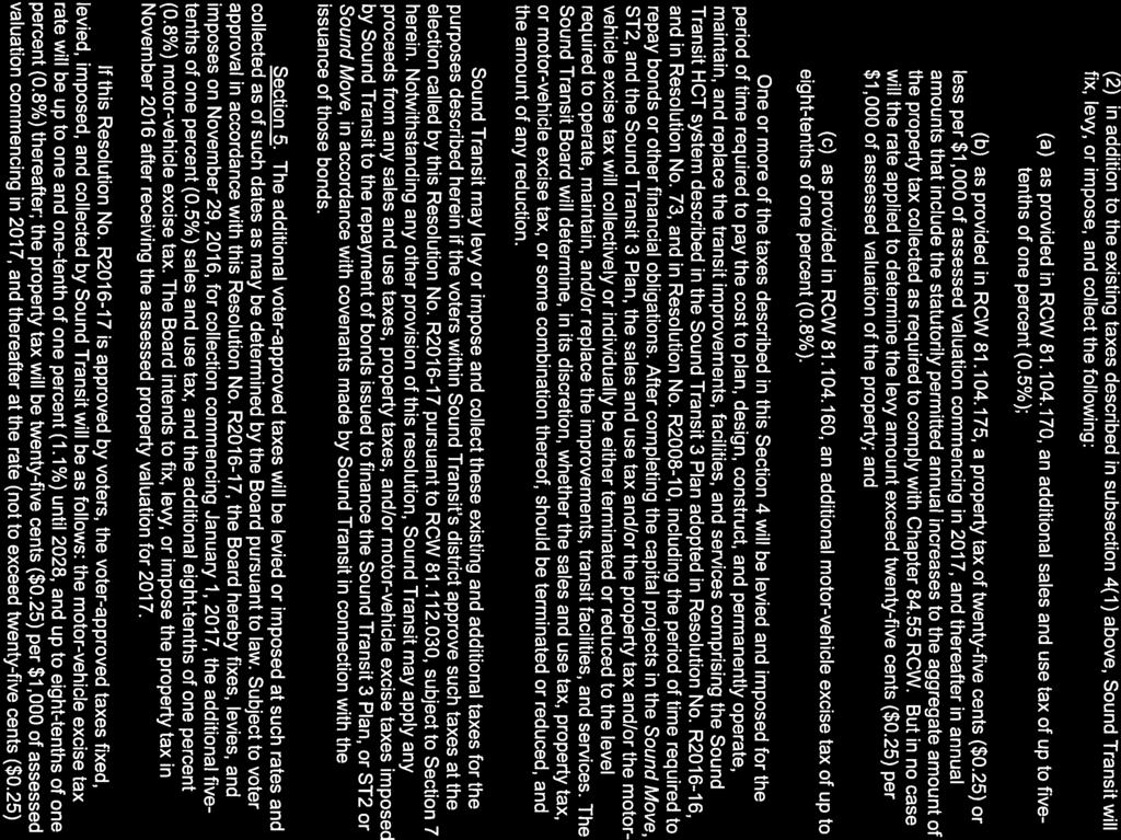
7 WHEREAS, to implement the ST3 Plan, the Sound Transit Board passed Resolution No. R2016-l 7 (June 23, 2016), declaring its intent to implement the ST3 Plan, to continue to develop regional HCT corridors and services by expanding Link light rail, Sounder commuter rail, and bus rapid transit, and to continue interim ST Express bus service; and WHEREAS, Resolution No. R declared the approximate cost of the ST3 Plan to be $53.8 billion and stated that voter approval of the Resolution and the ST3 Plan incorporated by reference in the Resolution will authorize the imposition, levy, and collection of certain taxes to fund the planning, design, construction, and ongoing operations and maintenance of the transportation projects and services that are part of the ST3 Plan, ST2 and Sound Move; and WHEREAS, in Resolution No. R2016-l 7, the Sound Transit Board designated Resolution No. R to be the Proposition that will be submitted to the voters at the general election on November 8, 2016; and WHEREAS, in Section 12 of Resolution No. R2016-l7, the Sound Transit Board directed the Chief Executive Officer of Sound Transit to certify to the Pierce County and Snohomish County Auditors and to the King County Elections Director, a copy of the ballot title for Resolution No.R , which will be in substantially the following form: and; Sound Transit (A Regional Transit Authority) Light-Rail, Commuter-Rail, and Bus Service Expansion Proposition No. 1 The Sound Transit Board passed Resolution No. R concerning expansion of mass transit in King, Pierce, and Snohomish counties. This measure would expand light-rail, commuter-rail, and bus rapid transit service to connect population,employment and growth centers, and authorize Sound Transit to levy or impose: an additional 0.5% sales and use tax; a property tax of $0.25 or less per $1,000 of assessed valuation; an additional 0.8% motor-vehicle excise tax, and continue existing taxes to fund the local share of the $53.8 billion estimated cost (including inflation), with independent audits, as described in the Mass Transit Guide and Resolution R Should this measure be: Approved... Rejected... WHEREAS, in compliance with RCW , the public meeting notice included the title and number of the King County Sound Transit 3 measure and members of the public were given equal opportunity to give testimony on the measure; 8a-7
8 NOW, THEREFORE, THE CITY COUNCIL OF THE CITY OF SHORELINE, WASHINGTON, HEREBY RESOLVES AS FOLLOWS: Section 1: The City Council supports the ballot proposition stated in Section 12 of Sound Transit Resolution No. R , relating to the expansion of light-rail, commuter rail, and bus rapid transit with Sound Transit s boundaries known as the Sound Transit 3 plan to be placed on the November 8 th, 2016 ballot. ADOPTED BY THE CITY COUNCIL ON AUGUST 8, Mayor Christopher Roberts ATTEST: Jessica Simulcik Smith, City Clerk 8a-8
9 SOUND TRANSIT 3 SYSTEM PLAN PROJECT LIST The following list describes projects approved as part of the Sound Transit 3 Plan adopted by the Sound Transit Board of Directors on June 23, PROJECT NAME MODE DESCRIPTION Redmond Technology Center Station to Downtown Redmond Light Rail LIGHT RAIL TRANSIT PROJECTS This project extends East Link to downtown Redmond, as described in Sound Transit Board Resolution R and the FTA and FHWA Record of Decision. The project would include two new stations, one with parking at southeast Redmond and a second in downtown Redmond. Project completion: 2024 Kent/Des Moines to Federal Way Transit Center Federal Way Transit Center to Tacoma Dome Downtown Seattle to West Seattle Ballard to Downtown Seattle Downtown Seattle Light Rail Tunnel Light Rail Light Rail Light Rail Light Rail Light Rail This project extends light rail south from Kent/Des Moines to Federal Way, with stations serving South 272 nd Street and the Federal Way Transit Center. The scheduled opening from Angle Lake to Kent/Des Moines has been adjusted to open at the same time as the extension to Federal Way. Project completion: 2024 This project extends light rail from the Federal Way Transit Center to Tacoma via I-5 with four new stations in the south Federal Way, Fife and east Tacoma areas, and at the Tacoma Dome Station. Project completion: 2030 This project builds light rail from downtown Seattle to the vicinity of West Seattle s Alaska Junction neighborhood with an alignment primarily on an elevated guideway, and a new rail-only fixed span crossing of the Duwamish River. This project includes five new or expanded stations at the Stadium, Delridge, Avalon, and Alaska Junction areas, with a transfer connection at SODO. Project completion: 2030 This project builds light rail from downtown Seattle to Ballard s Market Street area with a new rail-only subway through Seattle Center/Uptown and South Lake Union. The project will be constructed in conjunction with a new downtown Seattle light rail tunnel, which will extend from International District/Chinatown to the Denny Station. The Ballard to downtown Seattle project includes elevated light rail on 15 th Avenue West and Elliott Avenue West and a rail-only movable bridge over Salmon Bay. Five new stations serve the areas of South Lake Union, Seattle Center, Smith Cove, Interbay and Ballard. Project completion: 2035 This project builds a second light rail tunnel in downtown Seattle that provides capacity for the entire system to move through this area. The tunnel will be constructed as part of the Ballard to downtown Seattle light rail project, which includes a subway that extends from downtown Seattle through the Seattle Center/Uptown and South Lake Union neighborhoods. The downtown tunnel will extend from International District/Chinatown to the Denny Station with four new and expanded stations at International District/Chinatown, Midtown, Westlake and Denny. Project Completion: 2035 Lynnwood to Everett Light Rail This project extends light rail from the Lynnwood Transit Center to Everett Station via the Southwest Everett Industrial Center with both elevated and at-grade sections. The project includes six new stations at West Alderwood Mall, Ash Way, Mariner, Southwest Everett Industrial Center, SR 526/Evergreen and Everett Station. The project also includes one provisional station, at SR 99/Airport Road. This provisional station would require identification of additional funding not currently included in the ST3 System Plan in order to be built. Project completion: 2036 South Kirkland to Issaquah Light Rail This project builds light rail from south Kirkland to Issaquah with four new stations at south Kirkland, the Richards Road area, Eastgate near Bellevue College, and central Issaquah, with one provisional station in the Lakemont area. This provisional station would require identification of additional funding not currently included in the ST3 System Plan in order to be built. Project completion: 2041 Infill Light Rail Station: South Graham Street Light Rail This project builds a new infill station on the Link light rail line in the vicinity of South Graham Street. Project completion: 2031 Infill Light Rail Station: Light Rail This project builds a new infill station on the Link light rail line in the vicinity of South Boeing Access Road and I-5. South Boeing Access Road Project completion: 2031 Infill Light Rail Station: Northeast 130 th Street Light Rail This project builds a new infill station at I-5 and NE 130 th Street along the Lynnwood Link Extension. Project completion: 2031 Tacoma Link Extension to Tacoma Community College Light Rail I-405 Bus Rapid Transit Bus Rapid Transit This project extends Tacoma Link system farther west to Tacoma Community College, adding six new stations. Project completion: 2039 BUS RAPID TRANSIT (BRT) & BUS PROJECTS This project establishes Bus Rapid Transit (BRT) from the Lynnwood Transit Center to the Burien Transit Center via I-405 and SR 518. The project relies on the I-405 express toll system where available, and Business Access Transit (BAT) lanes on SR 518 from Tukwila to Burien. Project elements include parking, station access improvements, and 11 stations, including a new transit center in South Renton and new stations at Northeast 85 th Street with BAT lanes extending toward Downtown Kirkland and at Northeast 44 th Street in Renton. Project completion: 2024 Northeast 145 th Street and SR 522 Bus Rapid Transit King County Metro Rapid Ride C and D and Madison Street Capital Improvements Bus Rapid Transit Bus Rapid Transit This project establishes BRT from the Link station at I-5 and Northeast 145 th Street to UW Bothell, with service continuing at lower frequencies to Woodinville. On Northeast 145 th Street, this project includes transit priority spot treatments to facilitate BRT movement through corridor bottlenecks. On SR 522 the majority of the corridor through Lake Forest Park, Kenmore and Bothell will feature BAT lanes, with transit-supportive enhancements on arterials from downtown Bothell to UW Bothell. This project includes nine pairs of stations with additional parking at Lake Forest Park, Kenmore and Bothell and an expanded transit center at UW Bothell. Project completion: 2024 This project provides a capped contribution to help design and implement transit priority improvements along King County Metro s Rapid Ride C and D lines that provide BRT service to Ballard and West Seattle as early deliverables to provide improved speed and reliability in advance of light rail starting operations to these areas. The project also includes a contribution to funding for Madison Street BRT in Seattle. Project completion: a-9
10 PROJECT NAME MODE DESCRIPTION ST Express Service Express Bus This project funds operations for ST Express regional bus service maintaining interim express bus service in future High Capacity Transit (HCT) corridors, with an emphasis on long-haul connections between population and employment centers and providing riders with access to rail hubs. Frequent service between Lakewood and Tacoma Dome Station is included. Project completion: ongoing Proposed Bus on Shoulder Program: Opportunities along I-5, I-405, I-90, SR 518, and SR 167 Bus This program provides opportunities for buses to use shoulders on freeway and state route facilities during periods of congestion in general traffic and/or HOV lanes. This program will require coordination and further study with transit partners, WSDOT and Federal Highway Administration in order to determine locations that may be feasible. Project completion: Capital Enhancements to Improve Bus Speed and Reliability between East Pierce County Cities and Sumner Sounder Station Bus Capital Enhancements for Speed, Reliability and Convenience along Pacific Avenue (Tacoma) North Sammamish Parkand-Ride Sounder South Capital Improvements Program Sounder Expansion to DuPont Bus Bus Bus parking Commuter Rail Commuter Rail This project provides capital improvements to facilitate the efficient flow of new and expanded bus connections to Sumner Station. Project completion: This project provides a capital contribution to Pierce Transit for bus capital enhancements for speed, reliability and convenience along Pacific Avenue in Tacoma. Project completion: This project builds a surface park-and-ride in north Sammamish. The site for the park-and-ride will be determined in coordination with the City of Sammamish. Project completion: 2024 SOUNDER COMMUTER RAIL PROJECTS This project establishes a program of capital elements that would be used to meet growing demand for Sounder South. Access elements could include improvements for pedestrians, bicyclists, buses, and private vehicles, prioritized per Sound Transit s Access Policy. Additional program elements include extending platforms to accommodate trains up to 10 cars in length, track and signal upgrades, and other related infrastructure to facilitate additional capacity. Project completion: This project extends Sounder commuter rail service from Lakewood to DuPont with two new stations with parking at Tillicum and DuPont. Project completion: 2036 Sounder North Parking Future System Planning HCT Study: Light rail extending from West Seattle to Burien, Tukwila and Renton HCT Study: Northern Lake Washington HCT Study: Commuter Rail to Orting HCT Study: Connections from Everett to North Everett HCT Study: Tacoma Dome Station to Tacoma Mall HCT Environmental Study: Bothell to Bellevue System Access Program (Pedestrian and bicycle access, bicycle parking, transit) Commuter Rail This project would provide an early deliverable within the ST3 System Plan by providing additional parking at Mukilteo and Edmonds Sounder Stations. Project completion: 2024 HIGH CAPACITY TRANSIT (HCT) STUDIES, POLICIES & PROGRAMS Policies and Programs Light Rail Light Rail Commuter Rail Light Rail Light Rail HCT Policies and Programs This project includes funds for planning efforts supporting continued progress toward implementing Sound Transit s Long-Range Plan. This study examines a light rail extension from West Seattle to Burien and to Renton via Tukwila International Boulevard Station. The study would be completed in coordination with local transit partners to examine a variety of options for service provision and to maximize opportunities for regional integration. This study would examine options for expanding light rail transit connections across northern Lake Washington that may be needed when ridership demand exceeds available capacity. This study would examine alternatives including and parallel to SR 522 and SR 520, as well as connections from Ballard to Kirkland, Sand Point to Kirkland, and Redmond and/or Bellevue. This study would also examine connections to the University of Washington. This study can consider potential upgrades in existing service and/or improved connections. It should be completed in coordination with local transit partners to examine a variety of options for service provision and to maximize opportunities for regional integration. This study examines a future commuter rail connection from Orting to Sounder south line service. This study examines a future light rail extension from Everett to north Everett. This study examines a future light rail extension from Tacoma Dome Station to the Tacoma Mall area. This study would complete an environmental study to examine HCT options from Bothell to Bellevue. This program would fund access improvements for Sound Transit stations and facilities including non-motorized access, bicycle parking and facilities, bus transit access, and expanded drop-off/pick-up as needed. This program includes a mode of access data collection program and station area access studies. Funds would be prioritized per Sound Transit s System Access Policy. This program would provide funding in addition to the non-motorized access funds included for individual projects. Innovation and Technology Program Transit-Oriented Development Planning Program Light Rail Operations and Maintenance Facilities Bus Operations and Maintenance Facility Policies and Programs Policies and Programs Light Rail Bus This program would fund research, analysis and implementation of innovative best practices, partnerships and technologies to increase ridership, improve service and enhance efficiency of regional mobility outside of new investments in large capital projects. This program would fund Transit Oriented Development (TOD) analysis and support beyond the planning phase of transit capital project development in anticipation of sale, lease, or transfer of surplus properties or air rights to third parties. All analysis and property disposition would be conducted in accordance with applicable board policy including TOD Policy (Resolution No. R ). This program would provide funding in addition in the ST3 funds assumed for regional equitable TOD strategy. This project would construct two new light rail operations and maintenance facilities to accommodate additional fleet capacity; one in the Lynnwood to Everett corridor and one in the Federal Way to Tacoma corridor. Specific locations will be determined as part of light rail development in each corridor. This project would construct a new bus operations and maintenance facility to accommodate a portion of the existing and future bus fleet required for ST3 BRT and ST Express bus service. The facility would be located in the vicinity of the I-405/SR 522 corridors. Light Rail Vehicles Light Rail This project would purchase 226 new light rail vehicles required to operate the ST3 light rail system. 8a-10
11 8a-11
12 8a-12
13 8a-13
14 8a-14
15 8a-15
16 8a-16
17 8a-17

18 8a-18
19 RESOLUTION NO. R EXHIBIT A-1 NARRATIVE DESCRIPTION REGIONAL TRANSIT AUTHORITY BOUNDARY The following description provides a listing of the features that were used as the boundary for the Regional Transit Authority as approved by Resolution No. 37 on September 23, 1994, as amended by resolution No. 53 adopted January 13, 1995, as amended by resolution No. 75 adopted August 23, 1996, as amended by resolution No. 10 adopted June 13, 2002 and as amended by resolution No. R , adopted May 23, Additionally, the boundary of the Regional Transit Authority has been amended by annexations pursuant to Substitute Senate Bill The names for the physical features are those contained in the 2001 Thomas Guide. All references to City Limit boundaries and Corporation boundaries are those that were in force as of August 1996, unless otherwise stated. All references to roads and highways refer to the Right of Way of that road or highway which is farthest from the center of the Regional Transit Authority district as described in this text, unless otherwise stated in the text. All references to railroad Right of Ways refer to the Right of Way which is farthest from the center of the Regional Transit Authority district as described in this text, unless otherwise stated in the text. All references to rivers, creeks and other waterways refer to the center or the centerline of the water body, unless otherwise described. Snohomish County Beginning at the intersection of the shore of Possession Sound and the Snohomish River proceeding easterly following the Snohomish River to the western boundary of the area annexed to Everett by Everett City Ordinance , Continuing northerly, following the western boundary of the area annexed to Everett by Everett City Ordinance to the north shore of Smith Island on Possession Sound, Easterly through Possession Sound to Steamboat Slough, Easterly along Steamboat Slough to Interstate 5, Southerly on Interstate 5 to 12th Street NE, East on 12th Street NE to 51st Avenue NE and the east boundary of Section 16, Township 29N, Range 5E, South along the east boundary of Section 16, Township 29N, Range 5E to Union Slough, Southwesterly following Union Slough to the intersection with the Snohomish River, Generally southerly, following the Snohomish River to the east line of Section 5, Township 28N, Range 5E, South along the west boundary of Section 4, Township 28N, Range 5E to the E-W centerline of Section 4, Township 28N, Range 5E, East along the E-W centerline of Section 4, Township 28N, Range 5E to the N-S centerline of said Section and the western boundary of the Marshland Annexation to Everett, as approved by Everett City Ordinance , North, thence southeasterly, thence west, thence southeasterly, thence southwesterly, thence southerly, thence west along the Marshland Annexation to Everett boundary to west line of the SE Quarter of Section 4, Township 28N, R5E, South along the N-S centerline of Sections 4 and 9, Township 28N, Range 5E to the north boundary of Section 16, Township 28N, Range 5E, 8a-19
20 West along the north boundary of Section 16, Township 28N, Range 5E to Lowell-Larimer Road, Southeasterly on Lowell-Larimer Road to the northern boundary of Section 21, Township 28N, Range 5E, West along the northern boundary of Section 21, Township 28N, Range 5E to the NW corner of the NW Quarter of the NE Quarter of Section 21, Township 28N, Range 5E, South along the west boundary of the NW Quarter of the NE Quarter of Section 21, Township 28N, Range 5E, to the south boundary of the NW Quarter of the NE Quarter of Section 21, Township 28N, Range 5E East along the south boundary of the NW Quarter of the NE Quarter of Section 21, Township 28N, Range 5E to Lowell-Larimer Road, Southeasterly on Lowell-Larimer Road to west boundary of the SE quarter of the NE quarter of Section 21, Township 28N, Range 5E, South along the west boundary of the SE quarter of the NE quarter of Section 21, Township 28N, Range 5E, and the west boundary of the NE of the SE quarter of Section 21, Township 28N, Range 5E to the north boundary of the south half of the SE quarter of Section 21, Township 28N, Range 5E, East along the southern boundary of the north half of the SE Quarter, Section 21, Township 28N, Range 5E to 47th Ave SE Northeasterly along 47th Avenue SE to 112th Street SE, Easterly along 112 th Street SE to 111 th Place SE, Easterly along 111 th Place SE to the north boundary of the Waldenwood 5 plat, Easterly along the north boundary of the Waldenwood 5 plat to Lowell-Larimer Road, Southeasterly on Lowell-Larimer Road to Marsh Road, South on Marsh Road to Seattle Hill Road, Southwesterly on Seattle Hill Road to the northern margin of 132nd Street SE, East along the northern margin of 132nd Street SE to the centerline of 55th Ave SE, South along the centerline of 55th Ave SE to the north boundary of Section 34, Township 28N, Range 5E, East along the north boundary of Section 34, Township 28N, Range 5E to the northwest corner of Section 35, Township 28N, Range 5E, East along the north boundary of Section 35, Township 28N, Range 5E to the NE corner of the NW Quarter of the NW Quarter of section 35, South along the east boundary of the NW and SW Quarters of the NW Quarter of Section 35, Township 28N, Range 5E, and the east boundary of the NW Quarter of the SW Quarter of the Section 35, Township 28N, Range 5E to the SE corner of the NW Quarter of the SW Quarter of Section 35, Township 28N, Range 5E, West to the SW corner of the NW Quarter of the SW Quarter of Section 35, Township 28N, Range 5E, South along the eastern boundary of the SW Quarter of Section 35, Township 28N, Range 5E and the NW Quarter of Section 2, Township 27N, Range 5E to the northern boundary of the south 1/2 of NW Quarter of the NW Quarter of Section 2, Township 27N, Range 5E, East along the northern boundary of the south 1/2 of NW Quarter of the NW Quarter of Section 2, Township 27N, Range 5E to the eastern boundary of the west 1/2 of the NW Quarter of Section 2, Township 27N, Range 5E, South along the eastern boundary of the west 1/2 of the NW and the SW Quarters of Section 2, Township 27N, Range 5E to the northern boundary of the southern 1/2 of the NW Quarter of the SW Quarter of Section 2, Township 27N, Range 5E, 8a-20
21 West along the northern boundary of the southern 1/2 of the NW Quarter of the SW Quarter of Section 2, Township 27N, Range 5E to the eastern boundary of the west 1/2 of the NW Quarter of the SW Quarter of Section 2, Township 27N, Range 5E, South along the eastern boundary of the west 1/2 of the NW Quarter of the SW Quarter of Section 2, Township 27N, Range 5E to south boundary of the NW Quarter of the SW Quarter of Section 2, Township 27N, Range 5E, West along the south boundary of the NW Quarter of the SW Quarter of Section 2, Township 27N, Range 5E, and the south boundary of the north half of the SE Quarter, Section 3, Township 27N, Range 5E, to the east line of the SE Quarter, Section 3, Township 27N, Range 5E, North along the western boundary of the eastern 1/2 of Section 3, Township 27N, Range 5E to the southern boundary of the north half of the south half of the NW Quarter of Section 3, Township 27N, Range 5E, West along the southern boundary of the north half of the south half of the NW Quarter of Section 3, Township 27N, Range 5E to eastern boundary of Section 4, Township 27N, Range 5E, South along the eastern boundary of Section 4, Township 27N, Range 5E to 156 th Street SE, West on 156th Street SE to the southwest corner of SE Quarter of the NE Quarter of Section 4, Township 27N, Range 5 E, North along the eastern boundary of the west half of the NE Quarter of Section 4, Township 27N, Range 5E to the northern boundary of said Quarter Section, North along the eastern boundary of the west half of the SE Quarter of Section 33, Township 28N, Range 5E to the north line of the south half of the south half of the SE Quarter, Section 33, Township 28N, Range 5E, West along the north line of the south half of the south half of the SE Quarter, Section 33, Township 28N, Range 5E to the western boundary of the Olympic Pipeline right of way, Northerly along the western boundary of the Olympic Pipeline right of way to 144th Street SE, West on 144th Street SE to Seattle Hill Road, Southwesterly on Seattle Hill Road to 35th Avenue SE, Southerly on 35th Avenue SE to York Road, Southeasterly on York Road to Jewell Road, South on Jewell Road to Maltby Road, Southeasterly on Maltby Road to the eastern boundary of Section 21, Township 27N, Range 5E, South along the eastern boundary of Section 21, Township 27N, Range 5E, to the southeast corner of said section, West along the southern boundary of Section 21, Township 27N, Range 5E, to 45th Avenue SE extended, South on 45th Avenue SE extended and 45th Avenue SE to 240th Street SE, East on 240th Street SE to 47th Avenue SE, South on 47th Avenue SE to the Snohomish-King County Boundary, 8a-21
22 King County East along the Snohomish-King County Boundary to 170th Avenue NE, Southerly on 170th Avenue NE to NE 195th Street, West on NE 195th Street to 170th Avenue NE, Southerly on 170th Avenue NE and extension extended to NE 190th Street, East on NE 190th Street to 171st Place NE, South on 171st Place NE to NE Woodinville-Duvall Road (NE 185th Street), West on NE Woodinville-Duvall Road to 167th Avenue NE, South on 167th Avenue NE to NE 180th Place, Southwesterly on NE 180th Place to NE 180th Street, West on NE 180th Street to 164th Avenue NE, South on 164th Avenue NE to NE 175th Street, Westerly on NE 175th Street to 155th Place NE, Southerly on 155th Place NE to NE 173rd Street, Westerly on NE 173rd Street to 146th Place NE, Southerly on 146th Place NE to NE 171st Street, Westerly on NE 171st Street to the western margin of 140th Court NE, South following the western margin of 140th Court NE and 140th Court NE extended to the south boundary of the Kyes Annexation to Woodinville, approved by Woodinville City Ordinance No. 132, Westerly, following the south boundary of the Kyes Annexation to Woodinville to 140th Avenue NE, Northerly on 140th Avenue NE to NE 171st Street, Westerly on NE 171st Street to the 1992 Woodinville Corporation Boundary, established by King County Ordinance No , South along the 1992 Woodinville Corporation Boundary, established by King County Ordinance No to the Sammamish River, Southeasterly following the Sammamish River to NE 145th Street, East on NE 145th Street to the 1992 Woodinville Corporation Boundary, established by King County Ordinance No , North, thence east, thence north, thence east, thence south, thence east, thence south along the 1992 Woodinville Corporation Boundary to south line of the SW Quarter, Section 14, Township 26N, Range 5E, South, thence southwesterly, thence southeasterly, thence southwest to Woodinville Redmond Road, Southeast on Woodinville Redmond Road to NE 143rd Street, Southwest on NE 143rd Street to the Sammamish River, Northwest following the Sammamish River to NE 145th Street, West on NE 145th Street to the east margin of the Burlington Northern Railroad Right of Way and the 1992 Woodinville Corporation Boundary, Southerly following the east margin of the Burlington Northern Railroad Right of Way to the E-W center line of Section 22, Township 26N, Range 5E, East along the E-W centerline of Sections 22 and 23, Township 26N, Range 5E to Woodinville Redmond Road (156th Avenue NE), Southeasterly on Woodinville Redmond Road to NE 132nd Street extended, East on NE 132nd Street and NE 132nd Street extended to 172nd Avenue NE, North, thence northeast on 172nd Avenue NE to NE 141st Street, Southeast on NE 141st Street to 178th Ave NE, Southerly on 178th Ave NE tone 139th Street, 8a-22
23 East on NE 139th Street to 180th Avenue NE, Southeasterly on 180th Avenue NE to the west line of the SW quarter, Section 19, Township 26N, Range 6E, North along the west line of Section 19, Township 26N, Range 6E to the southwest corner of Section 18, Township 26N, Range 6E, East along the south line of Section 18, Township 26N, Range 6E to Avondale Road NE, Southwesterly on Avondale Road NE to NE 100 th Court extended, East along the extended centerline of NE 100 th Court to Bear Creek, Southeasterly following Bear Creek to NE Novelty Hill Road, Southwesterly along NE Novelty Hill Road to the western boundary of the Elm Court plat, as recorded by the King County Auditor under recording number , South along the western boundary of the Elm Court plat to the northwestern corner of Lot 7 of said plat, as recorded by the King County Auditor under recording number , Easterly along the northern boundary said Lot 7 and the northern boundary of Elm Court plat Tract B, as recorded by the King County Auditor under recording number to the northeast corner of said Tract B, South along the east line of Tract B and extension to the northern margin of NE 95th Street, East to west line of the NE quarter, Section 6, Township 25N, Range 6E, East along the northern margin of NE 95th Street for a distance of 630 feet, South to the southern margin of NE 95th Street, East along the southern margin of NE 95th Street to the east line of the west half of the of the west half of the NE quarter, Section 6, Range 25N, Range 6E, South along east line of the west half of the west half of the NE quarter, Section 6, Range 25N, Range 6E to the south line of the NE quarter, Section 6, Township 25N, Range 6E, East along the south line of the NE quarter, Section 6, Township 25N, Range 6E to the east line of the west half of the SE quarter, Section 6, Township 25N, Range 6E, South along east line of the west half of the SE quarter, Section 6, Township 25N, Range 6E to the north line of the south half of the SE quarter, Section 6, Township 25N, Range 6E, East along the north line of the south half of the SE quarter, Section 6, Township 25N, Range 6E to the east line of the west half of the east half of the SE quarter, Section 6, Township 25N, Range 6E, South along the east line of the west half of the east half of the SE quarter, Section 6, Township 25N, Range 6E to NE Union Hill Road, East on NE Union Hill Road to 196th Avenue NE, South, thence west, thence southerly, thence east, thence southeasterly following the eastern boundary of the Arthur Johnson Park annexation to Redmond, as approved by Redmond City Ordinance 822, to the boundary of the SE Redmond Neighborhood Annexation to Redmond, as approved by Redmond City Ordinance 1846, Southeasterly along the eastern boundary of the SE Redmond Neighborhood Annexation to Redmond Fall City Road (State Route 202), Easterly on Redmond-Fall City Road to 192nd Drive NE, South on 192nd Drive NE to 192nd Place NE, Southeasterly on 192nd Place NE to NE 50th Street, Easterly on NE 50th Street to Sahalee Way NE, Southeasterly on Sahalee Way NE to the south boundary of Section 22, Township 25N, Range 6E, East along the south boundary of Section 22, Township 25N, Range 6E to the N-S centerline of the west one-half of Section 22, Township 25N, Range 6E, 8a-23
24 North along the N-S centerline of the west one-half of Section 22, Township 25N, Range 6E to NE 25th Way, Easterly on NE 25th Way to 236th Avenue NE, South on 236th Avenue NE to NE 20th Street, East on NE 20th Street to 244th Avenue NE, Northerly on 244th Avenue NE to Redmond Fall City Road, Southeasterly on Redmond Fall City Road to the west boundary of Range 7E, South along the west boundary of Range 7E to the NW corner of the SW Quarter of Section 06, Township 24N, Range 7E, East, thence southeasterly, thence southwesterly, thence westerly, thence southerly along the eastern boundary of the Aldarra/Montaine Annexation to the City of Sammamish, as approved by Sammamish City Ordinance O to the north boundary of the SW Quarter of Section 7, Township 24 N, Range 7E, West along the E-W centerline of Section 7, Township 24N, Range 7E to western boundary of said section, West along the south line of the north half of Sections 12 and 11, Township 24N, Range 6E to SE Issaquah-Beaver Lake Road, Southeasterly on SE Issaquah-Beaver Lake Road to the intersection with SE Duthie Hill Road (264th Place SE), Southeasterly from the intersection of SE Issaquah-Beaver Lake Road and SE Duthie Hill Road (264th Place SE) to the eastern edge of the SE Duthie Hill right of way, Southwesterly along the eastern edge of the SE Duthie Hill right of way to the boundary of the Klahanie Annexation to Sammamish, approved by City of Sammamish Ordinance R , Southwesterly on SE Duthie Hill Road to SE Issaquah Fall City Road to the intersection with the west line of Section 23, Township 24N, Range 6E, Thence south along said west line to the south line of the Klahanie Annexation to Sammamish, Thence following the boundary of the Klahanie Annexation to Sammamish to the boundary of the North Issaquah Annexation to Issaquah, approved by City of Issaquah Ordinance No. 2255, Thence following the easterly boundary of the North Issaquah Annexation to the east line of the SE quarter of Section 22, Township 24N, Range 6E and the boundary of the Grand Ridge Annexation to Issaquah, approved by City of Issaquah Ordinance No. 2112, Northerly, thence easterly, thence southerly, thence easterly, thence westerly along the boundary of the Grand Ridge Annexation to Issaquah, to the boundary of the Issaquah Pointe Annexation to Issaquah, approved by City of Issaquah Ordinance No. 2606, located on the south line of the SE quarter, Section 23, Township 24N, Range 6E, Southerly, thence westerly along the boundary of the Issaquah Pointe Annexation to Issaquah to the boundary of the Grand Ridge Annexation to Issaquah, Southerly, thence westerly along the boundary of the Grand Ridge Annexation to Issaquah to the boundary of the SPAR Annexation to Issaquah, approved by Issaquah City Ordinance No. 2227, Southerly along the boundary of the SPAR Annexation to Issaquah to Interstate 90, Easterly on Interstate 90 to the east line of the SW quarter of the SW quarter of Section 25, Township 24N, Range 6E, South along the east line of the SW quarter of the SW quarter of Section 25, Township 24N, Range 6E to the south line of Section 25, Township 24N, Range 6E, 8a-24
25 West along the south line of Section 25, Township 24N, Range 6E to the NE corner of Section 35, Township 24N, Range 6E, South along the east line of the Section 35, Township 24N, Range 6E to the SE corner of the NE quarter of Section 35, Township 24 N, Range 6E, West along the south line of the NE quarter of Section 35, Township 24N, Range 6E to the SW corner of the NE quarter of Section 35, Township 24N, Range 6E, North along the west line of the NE quarter of Section 35, Township 24N, Range 6E, to the south line of the north half of the NW quarter of Section 35, Township 24 N, Range 6E, West along the south line of the north half of the NW quarter of Section 35, Township 24 N, Range 6E, to the NE corner of the SW quarter of the NW quarter of Section 35, Township 24N, Range 6E, South along east line of the west half of the west half of Section 35, Township 24 N, Range 6 E to the south line of the north half of the NW quarter of the SW quarter of Section 35, Township 24 N, Range 6E, West along south line of the north half of the NW quarter of the SW quarter of Section 35, Township 24N, Range 6E to the east boundary of Section 34, Township 24N, Range 6E, North along the east boundary of Section 34, Township 24N, Range 6E to the northeast corner of Section 34, Township 24N, Range 6E, West along the north boundary of Section 34, Township 24N, Range 6E to the Burlington Northern Railroad Right of Way, Southwesterly following the Burlington Northern Railroad Right of Way to the south line of the north half of the NW quarter, Section 34, Township 24N, Range 6E, East along the south line of the north half of the NW quarter, Section 34, Township 24N, Range 6E to the east line of the NW quarter, Section 34, Township 24N, Range 6E, South along the east line of the NW quarter, Section 34, Township 24N, Range 6E, to the boundary of the ParkPointe Annexation to Issaquah, approved by Issaquah City Ordinance No. 2113, East, thence northeasterly along the boundary of the ParkPointe Annexation to Issaquah to the east line of the west half of the east half of Section 34, Township 24N, Range 6E, South along the east line of the west half of the east half of Section 34, Township 24N, Range 6E to south line of the north half of the SE quarter, Section 34, Township 24N, Range 6E, West along the south line of the north half of the SE quarter, Section 34, Township 24N, Range 6E to the east line of west half of the east half of the west half of the SE quarter, Section 34, Township 24N, Range 6E, South along the east line of west half of the east half of the west half of the SE quarter, Section 34, Township 24N, Range 6E to SE 96th Street, West on SE 96th Street to Issaquah Hobart Road, Southeasterly, thence south on Issaquah Hobart Road to the south line of NE quarter, Section 3, Township 23N, Range 6E, West along south line of the NE quarter and the NW quarter of Section 03, Township 23N, Range 6E to the west line of the east half of the NW quarter, Section 03, Township 23N, Range 06E, North along the west line of the east half of the NW quarter, Section 03, Township 23N, Range 6E to the south line of the north half of the NW quarter, Section 03, Township 23N, Range 6E, West along the south line of the north half of the NW quarter, Section 03, Township 23N, Range 6E. to the west line of Section 03, Township 23N, Range 6E, North along the west line of Section 03, Township 23N, Range 6E to the south line of Section 33, Township 24N, Range 6E, 8a-25
26 West along the south line of Section 33, Township 24N, Range 6E to the SW corner of said section, North along the west boundary of Section 33, Township 24N, Range 6E to the southeast corner of the McCarry Woods annexation to Issaquah, as approved by City ordinance 2694, West, thence north, thence east along the boundary of the McCarry Woods annexation to the east boundary of Section 32, Township 24N, Range 6E, North along the east boundary of Section 32, Township 24N, Range 6E to the northeast corner of said section, North along the east boundary of Section 29, Township 24N, Range 6E to the SE corner of the NE quarter of the SE quarter of said section, Northerly along the east boundary of Section 29, Township 24N, Range 6E for a distance of feet, Westerly, parallel with the south line of the NE quarter of the SE quarter of Section 29, Township 24N, Range 6E, to 17th Ave NW, Southwesterly on 17th Ave NW to Renton Issaquah Road (State Route 900), Southwesterly on Renton Issaquah Road to the east boundary of Section 6, Township 23N, Range 6E, North along the east boundary of Section 6, Township 23N, Range 6E and Sections 31 and 30, Township 24N, Range 6E to the south boundary of Section 19, Township 24N, Range 6E, West along the south line of Section 19, Township 24N, Range 6E to the southwest corner of said section, Continuing west along the south line of Section 19, Township 24N, Range 6E and the southern boundary of the Cougar Glen Annexation to Bellevue approved by Bellevue City Ordinance 4150, Thence following the course of the Cougar Glen Annexation northerly, westerly, and southerly to its intersection with the south line of Section 24, Township 24N, Range 6 E, West along the south line of Section 24, Township 24N, Range 6 E and the Cougar Glen Annexation boundary to a point feet more or less from the southeast corner of said section, Thence northerly along the boundary of the Cougar Glen Annexation to the south margin of SE Cougar Mountain Dr., Thence north to the north margin of SE Cougar Mountain Dr., Thence easterly along the north margin of SE Cougar Mountain Dr. to its intersection with the boundary of the Cougar Glen Annexation, North then following the boundary of the Cougar Glen Annexation in a westerly and southerly direction to its intersection with the north line of SE Cougar Mountain Dr, Easterly along the north margin of SE Cougar Mountain Dr to a point on a line at right angles to the south line of Section 24, Township 24N, Range 6 E and being 158 feet east of the west line of the SW quarter of the SW quarter of the SE quarter of said Section 24, Township 24N, Range 6 E, Thence south along said line to the south line of Section 24, Township 24N, Range 6 E, West along said south line and following the south line of the Cougar Glen Annexation to the Intersection with the south line of the Calhill Annexation to Bellevue, approved by Bellevue City Ordinance 4307, Westerly along the southern boundary of the Calhill Annexation to the eastern boundary of the Mortensen Annexation to Bellevue, as approved by Ordinance 4339, Southerly along the eastern boundary of the Mortensen Annexation to the northern boundary of the Mortensen II Annexation to Bellevue, as approved by Bellevue City Ordinance 4756, East, thence south along the eastern boundary of the Mortensen II Annexation to the boundary of the Mortensen Annexation to Bellevue, 8a-26
27 South, thence east, thence south, thence west, thence north, thence west along the southern boundary of the Mortensen Annexation to the eastern boundary of the Cougar Ridge Annexation to Bellevue, as approved by Bellevue City Ordinance 4425, South along the eastern boundary of the Cougar Ridge Annexation as approved by Bellevue City Ordinance 4425 to the northern boundary of the Cougar Ridge II Annexation, as approved by Bellevue City Ordinance 4733, South, west and southwesterly along the boundary of the Cougar Ridge II Annexation to the east boundary of the Lakemont Blvd. SE Right of Way Annexation, as approved by Bellevue City Ordinance 6069, Northerly and following the east boundary of the Lakemont Blvd. SE Right of Way Annexation to its intersection with the west boundary of the Cougar Ridge II Annexation, North, thence easterly, thence north along the boundary of the Cougar Ridge II Annexation to the southerly boundary of the Cougar Ridge Annexation, as approved by Bellevue City Ordinance 4425, Westerly along the southern boundary of the Cougar Ridge Annexation, as approved by Bellevue City Ordinance 4425 to the Forest Ridge Estates Annexation to Bellevue, as approved by Bellevue City Ordinance 3493, South then generally westerly, thence north along the southern boundary of the Forest Ridge Estates Annexation to Bellevue to the southern boundary of Section 22, Township 24N, Range 5E, West along the southern boundary of Section 22, Township 24N, Range 5E to the N-S centerline of Section 27, Township 24N, Range 5E, South along the N-S centerline of Section 27, Township 24N, Range 5E to the north line of the south half of the NE quarter, Section 27, Township 24N, Range 5E, East along the north line of the south half of the NE quarter, Section 27, Township 24N, Range 5E to the east line of said quarter section, South along the east line of the NE quarter, Section 27, Township 24N, Range 5E to Newcastle Golf Club Road, East along Newcastle Golf Club Road to the east line of the SW quarter, Section 26, Township 24N, Range 5E, South along the east line of the SW quarter, Section 26, Township 24N, Range 5E, and the east line of the NW quarter, Section 35, Township 24N, Range 5E to the north line of the south half of the NW quarter, Section 35, Township 24N, Range 5E, West along the north line of the south half of the NW quarter, Section 35, Township 24N, Range 5E to the east line of the NE quarter, Section 34, Township 24N, Range 5E, South along the east line of the NE quarter, Section 34, Township 24N, Range 5E, to the SE corner of the NE quarter, Section 34, Township 24N, Range 5E, East along the north line of the SW quarter, Section 35, Township 24N, Range 5E to the east line of the west half of said quarter section, South along the east line of the west half of the SW quarter, Section 35, Township 24N, Range 5E to south line of said quarter section, West along the south line of the SW quarter, Section 35, Township 24N, Range 5E to SE May Valley Road, Northwest along SE May Valley Road to east line of SE quarter, Section 34, Township 24N, Range 5E, South along the east line of the SE quarter, Section 34, Township 24N, Range 5E to the south line of said Quarter Section, West along the south line of SE Quarter, Section 34, Township 24N, Range 5E to the eastern boundary of the Stonegate Annexation to Renton, approved by Renton City Ordinance 4510, 8a-27
28 Generally southerly along the eastern boundary of the Stonegate Annexation to Renton, to the south line of the NE quarter, Section 3, Township 23N, Range 5E, West along the south line of the NE quarter, Section 3, Township 23N, Range 5E to the SW corner of the Stonegate Annexation to Renton, said point also being on the N-S centerline of the east half of Section 3, Township 23N, Range 5E, Thence southon the N-S centerline of the E 1/2 Section 3, Township 23N, Range 5E of the NW corner of the Maertins Annexation to Renton, as approved by Renton City Ordinance 5713, Thence east, thence south, thence west, thence northwest, thence north, thence west along the boundary of the Maertins Annexation to the N-S centerline of the E 1/2 of Section 3, Township 23N, Range 5E, South on the N-S centerline of the E 1/2 of Section 3, Township 23N, Range 5E to SE Renton Issaquah Road, Easterly on SE Renton Issaquah Road to boundary of the Windstone V annexation to Renton, as approved by Renton City Ordinance no. 5665, Northerly, thence easterly, thence southerly along the boundary of the Windstone V annexation to Renton to SE Renton Issaquah Road, Easterly on SE Renton Issaquah Road to 148th Avenue SE, South on 148th Avenue SE and Nile Ave NE to NE 4th Street, East on NE 4 th Street and SE 128th Street to 162nd Avenue SE, South on 162nd Avenue SE to northerly margin of SE 132nd Street, East along the northerly margin of SE 132nd Street to the easterly margin of 164th Avenue SE, Thence southerly on said easterly margin of 164th Avenue SE to the north line of the south half of the Northwest quarter of Section 13, Township 23N, Range 5E, Thence easterly on the north line of said south half of the Northwest quarter of Section 13, Township 23N, Range 5E to 175th Avenue SE, Southerly on 175th Avenue SE to SE 136th Street and SE 136th Street extended, East on SE 136th Street and SE 136th Street extended to 182nd Avenue SE, Southerly on 182nd Avenue SE to 183rd Avenue SE, South on 183rd Avenue SE to SE 147th Street, Westerly on SE 147th Street and northerly along 180th Avenue SE to the southeast corner of Lot 30, Renton Suburban Tracts Div. No. 6 plat, Westerly along the southern boundary of Lots 30 and 29, Renton Suburban Tracts Div. No. 6 plat to the SW corner of lot 29, and the southern boundary of the Renton Suburban Tracts Div. No. 6 plat, Continuing Westerly along the south boundary of the Renton Suburban Tracts Div. No. 6 plat to west line of the east half of the NE quarter, Section 24, Township 23N, Range 5E, South along the west line of the east half of the NE quarter, Section 24, Township 23N, Range 5E to the boundary of the Renton Suburban Tracts Div. No. 7 plat, Westerly along the southern boundary of the Renton Suburban Tracts Div. No. 7 plat to the eastern boundary of the Briarwood South No. 6 plat, North along the boundary of the Briarwood South No. 6 plat to SE 149th Street and the corner of Tract A of the Briarwood South No. 6 plat, Westerly along the northern boundary of Tract A of the Briarwood South No. 6 plat to the eastern boundary of the Skyfire Ridge Div. No. 1 plat, North along the eastern boundary of the Skyfire Ridge Div. No. 1 plat to corner of Tract C, Skyfire Ridge Div. No. 1, Westerly along the northern boundary of Tract C, Skyfire Ridge Div. No. 1 to the western boundary of said plat, 8a-28
29 Northerly along the western boundary of the Skyfire Ridge Div. No. 1 plat to the NE corner of Lot C and the SE corner of Lot B, King County Boundary Line Adjustment No. L97L0112, as recorded by King County Auditor under recording number , West along the south boundary of Lot B, King County Boundary Line Adjustment No. L97L0112 to the SW corner of said Lot B, North following the west boundary of the Lot B, King County Boundary Line Adjustment No. L97L0112, continuing north along the west boundary of Lot A of said King County Boundary Line Adjustment to the north line of the south half of the NE quarter, Section 23, Township 23N, Range 5E, Thence west on said north line of the south half of the NE quarter, Section 23, Township 23N, Range 5E to the boundary of the Briarwood West plat, Westerly along the southern boundary of the Briarwood West plat to the eastern boundary of Tract A, Briarwood West plat, Northerly along the eastern boundary of Tract A, Briarwood West Plat to the northern boundary of said plat, West along the northern boundary of said plat to 154th Place SE, Southerly on 154th Place SE to Jones Road, Northwesterly on Jones Road and Jones Place to the Cedar River, Northwesterly along the Cedar River to the Maplewood Golf Course Expansion Annexation to Renton, as approved by Renton City Ordinance 4156, Southwesterly along the eastern boundary of the Maplewood Golf Course Expansion Annexation to Renton to SE Renton Maple Valley Highway (State Route 169), Southeasterly on SE Renton Maple Valley Highway (State Route 169) to 161st Avenue SE, Southerly on 161st Avenue SE to the north boundary of the Valley Faire II plat, Easterly along the north boundary of the Valley Faire II plat to the west line of Section 24, Township 23N, Range 5E, South along the east line of Sections 23, 26 and 35, Township 23N, Range 5E to SE Petrovitsky Road, Westerly on SE Petrovitsky Road to the east line of Section 34, Township 23N, Range 5E, South along the east line of Section 34, Township 23N, Range 5E, continuing south along the east line of Section 3 Township 22N, Range 5E to SE 208th Street, West on SE 208th Street to the eastern boundary of the Panther Lake Annexation to Kent, as approved by Kent City Ordinance 3936, Southerly and southeasterly following the boundary of Panther Lake Annexation to Kent to the north boundary of the Meridian Valley Annexation to Kent, as approved by Kent City Ordinance 3344, Southeasterly, thence south along the boundary of the Meridian Valley Annexation to the Meridian Annexation to Kent, as approved by Kent City Ordinance 3241, Generally southerly, following the east boundary of the Meridian Annexation to Kent to State Highway 18, Southwesterly on State Highway 18 to the Green River, Northwesterly along the Green River to E Main Street extended, West on E Main Street extended and E Main Street to "R" Street SE, South on "R" Street SE to the southern boundary of the Steelhead South District Annexation to Auburn, as approved by Auburn City Ordinance 5732, Easterly, thence south along the southern boundary of the Steelhead South Annexation to 2 nd St SE, West along 2 nd Street SE to T Street SE, 8a-29
30 South along T Street SE to the southern boundary of the Rippey Annexation to Auburn as approved by Auburn City Ordinance 5350, East along to the southern boundary of the Rippey Annexation to the northwest corner of the Ward Annexation to Auburn, as approved by Auburn City Ordinance 4605, Thence east along the north line of said Ward Annexation to the east boundary of said annexation, Thence southeasterly along the east boundary of the Ward Annexation to northern boundary of the Fenster Annexation to Auburn, as approved by Auburn City Ordinance 4998, West, thence south, thence southeasterly along the boundary of the Fenster Annexation to the eastern line of the SW Quarter, Section 17, Township 21N, Range 5E, South along the eastern line of the SW Quarter, Section 17, Township 21N, Range 5E to Auburn Black Diamond Road, Easterly on Auburn Black Diamond Road to the N-S centerline of the west one-half of Section 21, Township 21N, Range 5E, South along the N-S centerline of the west one-half of Section 21, Township 21N, Range 5E to the boundary of the Nevitt-Danielson Annexation to Auburn, as approved by Auburn City Ordinance No. 4716, Generally southeasterly along the boundary of the Nevitt-Danielson Annexation to Auburn, to the north line of the south half of the south half of Section 21, Township 21N, Range 5E, East along the north line of the south half of the south half of Section 21, Township 21N, Range 5E to SE Green Valley Road, Southeasterly along SE Green Valley Road to the west line of the east half of the SE quarter, Section 21, Township 21N, Range 5E, South along the west line of the east half of the SE quarter, Section 21, Township 21N, Range 5E to the south line Section 21, Township 21N, Range 5E, East along the south line Section 21, Township 21N, Range 5E and Section 22, Township 21N, Range 5E to the Green River, Southeasterly along the Green River to the east line of Section 27, Township 21 N, Range 5E, South along the east line of Section 27, Township 21 N, Range 5E to the southeast corner of Section 27, Township 21N, Range 5E, West along the south boundary of Section 27, Township 21N, Range 5E to the White River, Southeasterly along the White River to the King/Pierce County Boundary, EXCEPT the area: From the intersection of SE 136th Street and 162nd Ave SE, east on SE 136th Street extended to 164th Avenue SE, North on 164th Avenue SE and 164th Avenue SE extended to south boundary of the Tess Annexation to Renton, West and south along the boundary of the Tess Annexation to Renton to162nd Avenue SE, South along162nd Ave SE to the intersection with SE 136th Street. Pierce County Westerly along the King/Pierce County Boundary to 182nd Avenue E, South on 182nd Avenue East and 182nd Avenue E extended to Lake Tapps, Southeasterly along the eastern shoreline of Lake Tapps to Island Parkway (E), Southeasterly on Island Parkway (E) to 214th Avenue E, Southerly on 214th Avenue E to 40th Street E, East on 40th Street E to 230th Avenue E, 8a-30
31 South on 230th Avenue E to Buckley Tapps Highway, Southeasterly on Buckley Tapps Highway to the NW corner of the Pierce County short plat , as recorded by the Pierce County Auditor, Northeasterly along the northern boundary of the short plat to the SW corner of Lot 1, in Pierce County short plat , as recorded by the Pierce County Auditor, Northerly along the western boundary of Lot 1, in Pierce County short plat to the NW corner of Lot 1, in Pierce County short plat as recorded by the Pierce County Auditor, Easterly along the northern boundary of Lot 1, in Pierce County short plat to the NW corner of Lot 1, in Pierce County short plat as recorded by the Pierce County Auditor, Easterly along the northern boundary of Lot 1, in Pierce County short plat to the NW corner of Lot 1, in Pierce County short plat , as recorded by the Pierce County Auditor, Easterly along the northern boundary of Lot 1, in Pierce County short plat to the NE corner of said Lot 1 and the east boundary of Range 5E, South along the east boundary of Range 5E to Old Sumner Buckley Highway, West on Sumner Buckley Highway to 234th Avenue E, South on 234th Avenue E to 96th Street E (Carlson Roberts Co. Road), West on 96th Street E (Carlson Roberts Co. Road) to 233rd Avenue E, South on 233rd Avenue E to State Route 410 E, Easterly on State Route 410 E to the east line of the west half of the NW quarter, Section 1, Township 19N, Range 5E, Southerly along the east line of the west half of the NW quarter, Section 1, Township 19N, Range 5E to 234th Avenue E, Southerly along 234th Avenue E and 234th Avenue E extended to the south boundary of Section 12, Township 19N, Range 5E, West along the south boundary of Section 12, Township 19N, Range 5E to the SW corner of said quarter section, Southwesterly on 129th Street East extended and 129th Street East to Cedarview Drive (E), Southwesterly on Cedarview Drive (E) to 133rd Street E, Southwesterly on 133rd Street E to Prairie Ridge Drive (E), Southwest on Prairie Ridge Drive (E) to Cedar Circle (E), Southwesterly on Cedar Circle (E) to Prairie Ridge Drive (E), Northeasterly on Prairie Ridge Drive (E) to Ridgewood Drive, Northwesterly on Ridgewood Drive to 215th Avenue E, Southerly on 215th Avenue E and 216th Avenue E to Prairie Ridge Drive (E), Southerly on Prairie Ridge Drive E to 143rd Street E, Southwesterly on 143rd Street E to 215th Avenue, Southerly on 215th Avenue to 148th Street E, Easterly on 148th Street E to 147th Street E, East on 147th Street E and 147th Street E, as it would be extended to the southeast to State Route 162 (Pioneer Way), Southwesterly on State Route 162 to the south line of the NW quarter, Section 34, Township 19 N, Range 5E, West along the south line of the NW quarter, Section 34, Township 19 N, Range 5E and the south line of the NE quarter, Section 33, Township 19N, Range 5E to the centerline of the utility easement recorded by the Pierce County Auditor under number , 8a-31
32 South along the centerline of the utility easement recorded by the Pierce County Auditor under number to the southern boundary of the northern 1/2 of the abandoned Burlington Northern Railroad Right of Way, Westerly following the southern boundary of the northern 1/2 of the abandoned Burlington Northern Railroad Right of Way to the first intersection with a southbound branch of the Burlington Northern Railroad Right of Way, South following the southbound branch of the abandoned Burlington Northern Railroad Right of Way to State Route 162, Southeast on State Route 162 to Orville Road E, Southerly on Orville Road E to the south line of Section 17, Township 18N, Range 5E, West along the south line of Section 17, Township 18N, Range 5E and the south line of Section 18, Township 18N, Range 5E to Country Drive E, Northerly on Country Drive E to 224th Street E, West on 224th Street E to the northeast corner of the NW Quarter Section 13, Township 18N, Range 3E, South along the east line of the NW Quarter Section 13, Township 18N, Range 3E to the south line of the north half of Section 13, Township 18N, Range 3E, West along the south line of the north half of Section 13, Township 18N, Range 3E to the closest Transmission Line Right of Way, South following the Transmission Line Right of Way to 260th Street E, West on 260th Street E to the southern boundary of the Fort Lewis Military Reservation boundary, Westerly along the southern boundary of the Fort Lewis Military Reservation boundary to 8th Avenue E, South on 8th Avenue E to 288th Street, West on 288th Street S extended and 288th Street S to 56th Avenue S, North on 56th Avenue S to 280th Street S, West on 280th Street S to the Fort Lewis Military Reservation boundary, Westerly, thence southwesterly following the Fort Lewis Military Reservation boundary to the Pierce/Thurston County boundary and the Nisqually River, Northwesterly along the Pierce/Thurston County Boundary to the Fort Lewis Military Reservation northwest boundary, Northwesterly along the west boundary of the Fort Lewis Military Reservation to the Burlington Northern Railroad Right of Way, Northerly following the Burlington Northern Right of Way to the Fort Lewis Military Reservation west boundary, North along the west boundary of the Fort Lewis Military Reservation to Mounts Road, West on Mounts Road to west boundary of the area annexed to the City of DuPont by DuPont City Ordinance 189, Northerly along said western boundary to the southern line of the NE Quarter, Section 33, Township 19N, Range 1E, West along the southern line of the NE Quarter, Section 33, Township 19N, Range 1E to the N-S centerline of Section 33, Township 19N, Range 1E, North along the N-S centerline of Section 33, Township 19N, Range 1E to the shore of Puget Sound, Northerly through Puget Sound passing east of Anderson Island, Ketron Island, McNeil Island, and Fox Island, and west of Day Island to The Narrows, Northerly through The Narrows to Dalco Passage, 8a-32
33 Easterly through Dalco Passage and East Passage passing south of Vashon Island and Maury Island to Puget Sound, Northerly through Puget Sound passing east of Maury Island, Vashon Island, and Blake Island to the west boundary of King County, Northerly following the west boundary of King County and passing east of Bainbridge Island to the Snohomish County boundary, Northerly following the west boundary of Snohomish County and passing east of Whidbey Island to Possession Sound, Northerly through Possession Sound passing east of Hat Island (Gedney Island) and Jetty Island to the point of beginning. 8a-33


34 January 19, 2016 Chairman Dow Constantine and Sound Transit Board Sound Transit 401 South Jackson Street Seattle, WA Dear Chairman Constantine and Members of the Board: The Mayors of Bothell, Kenmore, Lake Forest Park, Shoreline, and Woodinville are jointly writing to acknowledge proposed projects N-09, N-10, and P-08 as system plan candidates for Sound Transit 3. We are pleased to see these projects listed and with the detailed project information provided. As we stated in our July 8, 2015 joint letter requesting inclusion in the ST3 plan, these projects are critical for the SR 522/523 corridor as growth and congestion continues in the North Lake part of the region: 1. Bus Rapid Transit on SR 522 and NE 145 th Street (SR 523) 2. Structured Parking on the SR 522 Corridor 3. Study for Future Light Rail We greatly appreciate that the above requests are addressed in N-09, N-10, and P-08 and we ask that you consider the SR 522 and SR 523 projects as one joint project in your further deliberations. We strongly urge you to retain this joint project in the final ST3 system package. SR 522/NE 145 th Street is a major east-west transit corridor that is key in connecting riders to the light rail spine and making the overall transit system work building a complete network that ensures transit system success. There are additional compelling arguments to keep candidate projects N-09, N-10, and P-08 in the final ST3 package, including the following: Early Win. Given the projected cost and infrastructure already in place along this corridor, projects N-09 and N-10 should be delivered early to connect riders to the light rail spine upon opening in All components of these projects, including the proposed parking structures, will be needed for this early win. One Corridor, One Project. BRT on SR 522 and continuing onto 145th St. will be essential to getting riders to and from the new 145th Street light rail station scheduled to open in a-34
35 Connection of Regional HCT Spines. N-09, N-10, and P-08 will link the two regional High Capacity Transit spines I-5 Light Rail Spine and I-405 Bus Rapid Transit. Low Cost, High Ridership. Looking at cost per rider coupled with its strong market for ridership, BRT on the 522/145 th corridor is a relatively inexpensive project that will yield high ridership. Multi-Jurisdiction Support. The SR522/145th St. corridor projects are interregional and cross over subarea lines. As a result, multiple jurisdictions are united behind proposed projects N-09, N-10, and P-08. Major Cross-Lake Corridor with a Wide Geographic Reach. SR 522 carries 20% of cross lake trips today, connecting north end communities with the region s employment centers on both sides of the Lake. N-09, N-10, and P-08 will provide critical transit services for this major corridor as the region grows. In addition to the cities of Bothell, Kenmore, Lake Forest Park, Shoreline and Woodinville, the project enjoys multi-jurisdiction support from surrounding cities as well as strong grass-roots citizen support. The 522 Transit Now! coalition has formed around this very issue and they have gathered hundreds of signatures and supporters. We strongly believe that N-09, N-10, and P-08 are projects that our communities will be excited about and will rally around. Thank you again for this opportunity to acknowledge these important projects and provide input. These are exciting times for our region, and these transit improvements will go a long way toward building a better future for our communities. Sincerely, Christopher Roberts, Mayor City of Shoreline Jeff Johnson, Mayor City of Lake Forest Park David Baker, Mayor City of Kenmore Andrew J. Rheaume, Mayor City of Bothell Bernie Talmas, Mayor City of Woodinville 8a-35


36 April 6, 2016 Chairman Dow Constantine and Sound Transit Board Sound Transit 401 South Jackson Street Seattle, WA Dear Chairman Constantine and Members of the Board: We, along with our fellow councilmembers, are thrilled to see our requested projects in the Sound Transit 3 draft system plan. On behalf of our five cities, we thank you for listening to us and including Bus Rapid Transit on the SR522/145 th St. corridor, structured parking on the SR 522 corridor, and a light rail study for the corridor in ST3. We also appreciate the proposed timing for these projects, and we see their completion in 2024 as an early win that will reap significant benefits. For the reasons stated in our January 19, 2016 joint letter to you, we strongly urge you to retain our requested projects in the final ST3 system plan. We know there is still a lot of work to be done between now and final adoption in June, and we are here to help and provide any technical or other assistance we can. Again, thank you for your leadership on this important initiative that will mean so much to our region. We strongly support the proposed plan and urge the Sound Transit Board to submit this ST3 system package to the voters. Sincerely, Christopher Roberts, Mayor City of Shoreline Jeff Johnson, Mayor City of Lake Forest Park David Baker, Mayor City of Kenmore Andrew J. Rheaume, Mayor City of Bothell Bernie Talmas, Mayor City of Woodinville 8a-36
37 8a-37
38 8a-38
WELCOME AND AGENDA DOWNTOWN REDMOND LINK EXTENSION
 WELCOME AND AGENDA Welcome At tonight s open house you will have the opportunity to: See updated design plans for the southeast and downtown stations and track Help shape the look and feel of light rail
All questions in this survey were voluntary; all results are based on number of respondents who answered the relevant question.
 Online Survey Results Sound Transit 3 Draft Plan Introduction An online survey was one of the primary methods employed to solicit feedback on Sound Transit 3 Draft Plan. The results of the March 29 May
Welcome! This open house provides an early look at: Garage layout and access Potential pedestrian, bicycle and transit improvements
 Welcome! Sound Transit is improving access to Station for drivers, pedestrians, bicyclists and bus riders, including construction of a new garage. This open house provides an early look at: Garage layout
Updating the vision for regional transit
 Updating the vision for regional transit Sound Transit is beginning the process of analyzing transportation corridors throughout the region to identify which are most appropriate for future high capacity
Table of contents. Sound Transit 2 Plan map... A-2
 Table of contents Sound Transit 2 Plan map... A-2 Total agency Summary of estimated ST2 program costs and revenues... A-3 Total sources/uses of funds... A-4 Financial plan sources and uses summary for
CENTRAL AND EAST CORRIDORS
 HIGH-CAPACITY TRANSIT STUDY CENTRAL AND EAST CORRIDORS SEPTEMBER 2014 CORRIDOR REPORT: UNIVERSITY DISTRICT-KIRKLAND-REDMOND HIGH-CAPACITY TRANSIT CORRIDOR STUDY University District-Kirkland-Redmond Corridor
APPENDIX H Transportation Projects Considered for Cumulative Impact Analysis
 Final Supplemental Environmental Impact Statement on the Regional Transit Long-Range Plan APPENDIX H Transportation Projects Considered for Appendix H Transportation Projects Considered for Cumulative
DRAFT Service Implementation Plan
 2017 Service Implementation Plan October 2016 SECTION NAME 2017 Service Implementation Plan October 2016 2017 SERVICE IMPLEMENTATION PLAN TABLE OF CONTENTS Table of Contents... I List of Tables... III
ORDINANCE NO. 14,723
 ORDINANCE NO. 14,723 AN ORDINANCE providing that general property taxes levied and collected each year on all property located within the Beaverdale Commercial Area Urban Renewal Area in the City of Des
Sound Transit Service Standards and Performance Measures Edition
 Sound Transit Service Standards and Performance Measures 2018 Edition Table of Contents EXECUTIVE SUMMARY....1 INTRODUCTION TO SERVICE STANDARDS AND PERFORMANCE MEASURES....5 SERVICE DESIGN SERVICE PERFORMANCE
Interstate 90 and Mercer Island Mobility Study APRIL Commissioned by. Prepared by
 Interstate 90 and Mercer Island Mobility Study APRIL 2017 Commissioned by Prepared by Interstate 90 and Mercer Island Mobility Study Commissioned by: Sound Transit Prepared by: April 2017 Contents Section
2018 Service Implementation Plan Executive Summary
 2018 Service Implementation Plan Executive Summary March 2018 2018 SERVICE IMPLEMENTATION PLAN Executive Summary 2018 Service Implementation Plan Each year, Sound Transit prepares a Service Implementation
October 12th 2015 DRAFT Service Implementation Plan
 October 12th 2015 DRAFT 2016 Service Implementation Plan Page left intentionally blank 2016 Service Implementation Plan Executive Summary This coming year is shaping up to be one of the most significant
 Contact: Email: BenBroesamle,CoalitionCoordinator, contact@nwseattlecoalition.org / / / / April25,2016 TO: THESOUNDTRANSITBOARD CC: EDMURRAY,Mayor,CityofSeattle SEATTLECITYCOUNCIL KINGCOUNTYCOUNCIL RICIGENFRITZ,ExecutiveDirectorofPlanning,EnvironmentalandProject
ORDINANCE NO. 510 THEREFORE, BE IT ORDAINED BY THE GOVERNING BODY OF THE CITY OF BEL AIRE, KANSAS:
 (Published in The Ark Valley News on July, 2012.) ORDINANCE NO. 510 S-I-1 GILMORE & BELL, P.C. 07/11/2012 AN ORDINANCE CREATING A COMMUNITY IMPROVEMENT DISTRICT IN THE CITY OF BEL AIRE, KANSAS; AUTHORIZING
5.1 Traffic and Transportation
 5.1 When it opens in 2009, the Bellevue Nickel Improvement Project will increase the number of vehicles able to travel through the study area, improve travel speeds, and improve safety by reducing the
ORDINANCE NO. 13,729
 ORDINANCE NO. 13,729 AN ORDINANCE to amend the Municipal Code of Des Moines, 1991, adopted by Ordinance No. 11,651, passed April 15, 1991, and amended by Ordinance No. 13,561, passed January 5, 1998 by
CITY OF SNOHOMISH Snohomish, Washington ORDINANCE 2019 AN ORDINANCE OF THE CITY OF SNOHOMISH, WASHINGTON ESTABLISHING A NEW LAND USE DESIGNATION MAP.
 OF SNOHOMISH Snohomish, Washington ORDINANCE 2019 AN ORDINANCE OF THE OF SNOHOMISH, WASHINGTON EABLISHING A NEW LAND USE DESIGNATION MAP. WHEREAS, the City Council considers long-range planning as embodied
GREENSBORO-JAMESTOWN JOINT ANNEXATION AGREEMENT
 NORTH CAROLINA GUILFORD COUNTY GREENSBORO-JAMESTOWN JOINT ANNEXATION AGREEMENT THIS AGREEMENT, made and entered into this the day of, 2011 by and between the City of Greensboro and the Town of Jamestown.
RESOLUTION GRANTING A TWO YEAR EXTENSION TO SURE SANITATION SERVICE FOR RESIDENTIAL GARBAGE COLLECTION IN ORANGE counn
 RESOLUTION GRANTING A TWO YEAR EXTENSION TO SURE SANITATION SERVICE FOR RESIDENTIAL GARBAGE COLLECTION IN ORANGE counn WHEREAS, SURE SANITATION SERVICE is currently a licensed franchisee b~ ORANGE COUNTY
IN THE CHANCERY COURT OF LAMAR COUNTY, MISSISSIPPI CIVIL ACTION NO.: CITY OF HATTIESBURG, MISSISSIPPI
 IN THE CHANCERY COURT OF LAMAR COUNTY, MISSISSIPPI IN THE MATTER OF THE INCORPORATION OF THE CITY OF BELLEVUE, MISSISSIPPI, BELLEVUE INCORPORATORS VS. CITY OF HATTIESBURG, MISSISSIPPI PETITIONERS CIVIL
ORDINANCE NO. 612, DESCRIPTION ATTACHED
 Insert BOARD OF TRUSTEES, TOWN or PAGOSA SPRINGS STATE OF COLORADO ORDINANCE NO. 612, AMENDING ORDINANCE NO. 561, ESTABLISHING THE TOWN OF PAGOSA SPRINGS SANITATION ENERAL IMPROVEMENT DISTRICT, TO CLARIFY
CITY OF GRAND JUNCTION, COLORADO ORDINANCE NO. AN ORDINANCE ANNEXING TERRITORY TO THE CITY OF GRAND JUNCTION, COLORADO SOUTH TWENTY ANNEXATION
 Public Hearing: February 20, 2019 CITY OF GRAND JUNCTION, COLORADO ORDINANCE NO. AN ORDINANCE ANNEXING TERRITORY TO THE CITY OF GRAND JUNCTION, COLORADO SOUTH TWENTY ANNEXATION APPROXIMATELY 20.18 ACRES
Learn more and comment. See page 10 for details. Proposed Fall 2018 / Spring 2019 SERVICE EXPANSION. and FARE CHANGE
 Learn more and comment. See page 10 for details. Proposed Fall 2018 / Spring 2019 SERVICE EXPANSION and FARE CHANGE Proposed Fall 2018/Spring 2019 Service Expansion & Fare Change Community Transit proposes
East Link Extension. Park-and-ride options during East Link construction
 East Link Extension Park-and-ride options during East Link construction Spring 2017 When East Link opens in 2023, Eastside commuters will be able to travel from downtown Bellevue to downtown Seattle in
PETITION TO CONTINUE THE DOWNTOWN DES MOINES SELF-SUPPORTED MUNICIPAL IMPROVEMENT DISTRICT PURSUANT TO CHAPTER 386, CODE OF IOWA
 PETITION TO CONTINUE THE DOWNTOWN DES MOINES SELF-SUPPORTED MUNICIPAL IMPROVEMENT DISTRICT PURSUANT TO CHAPTER 386, CODE OF IOWA We, the undersigned, being at least 25 per cent of all owners of property
Memorandum. Roger Millar, Secretary of Transportation. Date: April 5, Interstate 90 Operations and Mercer Island Mobility
 Memorandum To: From: The Honorable Dow Constantine, King County Executive; The Honorable Ed Murray, City of Seattle Mayor; The Honorable Bruce Bassett, City of Mercer Island Mayor; The Honorable John Stokes,
East Link Project Update. Maintenance of Traffic During Construction. April 21, 2015
 East Link Project Update Maintenance of Traffic During Construction April 21, 2015 1 Agenda TFP project 242 Bellevue Way HOV Bellevue Way - Maintenance of Traffic During Construction Early Work Utilities
PLEASE READ Proposal for Sustainable Service
 IMPORTANT PLEASE READ 019 Proposal for Sustainable Service 019 Service Change Proposal IMPLEMENT A SUSTAINABLE NETWORK Everett Transit completed its Long Range Plan in May, and the plan was adopted by
Establishes a fare structure for Tacoma Link light rail, to be implemented in September 2014.
 RESOLUTION NO. R2013-24 Establish a Fare Structure and Fare Level for Tacoma Link MEETING: DATE: TYPE OF ACTION: STAFF CONTACT: PHONE: Board 09/26/2013 Final Action Ric Ilgenfritz, Executive Director,
1.2 Corridor History and Current Characteristics
 SECTION 1 Description and Background of Study Area 1.1 Introduction This preliminary engineering report was prepared for the Alaska Department of Transportation and Public Facilities (ADOT&PF). It is part
A RESOLUTION NOW, THEREFORE, BE IT RESOLVED BY THE CITY COUNCIL OF THE CITY OF EL PASO THAT:
 A RESOLUTION EXPRESSING THE CITY OF EL PASO S INTENT TO CREATE TRANSPORTATION REINVESTMENT ZONE NO. 1 TO FINANCE TRANSPORTATION PROJECTS IN SUPPORT OF THE COMPREHENSIVE MOBILITY PLAN FOR EL PASO; SETTING
Transportation 2040 as amended in 2015 Appendix N: Regional Capacity Projects
 Transportation 2040 as amended in 2015 Appendix N: Regional Capacity Projects Note: Project costs are expressed in 2015 dollars and are sorted by sponsor. Sponsor: AUBURN Project ID: 2858 Title: A St Trail
EXHIBIT 1. BOARD AUTHORIZATION FOR PUBLIC HEARING AND SUBSEQUENT ISSUANCE OF A JOINT DEVELOPMENT SOLICITATION
 EXHIBIT 1. BOARD AUTHORIZATION FOR PUBLIC HEARING AND SUBSEQUENT ISSUANCE OF A JOINT DEVELOPMENT SOLICITATION Washington Metropolitan Area Transit Authority Board Action/Information Summary @Action O Information
Community Development
 Community Development City & Borough of Juneau Community Development 155 S. Seward Street Juneau, AK 99801 (907) 586 0715 Phone (907) 586 4529 Fax DATE: February 11, 2016 TO: FROM: Planning Commission
(C)Flexible Fare Effective Date: May 1, 2014
Flexible Fare Effective Date: May 1, 2014") 1 st Revised Page 7 Tariff No. 11 Cancels Original Page 7 Door-to-Door Rate Schedule Fares named are for adults (persons 18 years age and over) stated in dollars and cents. One child 17 and under rides
1 st Revised Page 7 Tariff No. 11 Cancels Original Page 7 Door-to-Door Rate Schedule Fares named are for adults (persons 18 years age and over) stated in dollars and cents. One child 17 and under rides
DEMOGRAPHICS AND EXISTING SERVICE
 EXECUTIVE SUMMARY The Central Corridor light-rail transit (LRT) project will open in 2014 and operate between downtown Minneapolis and downtown St. Paul, serving the University of Minnesota and University
Title VI Service Equity Analysis
 Pierce Transit Title VI Service Equity Analysis Pursuant to FTA Circular 4702.1B September 2013 Service Change February 2013 Page intentionally left blank PIERCE TRANSIT TITLE VI SERVICE EQUITY ANALYSIS
* ** Stanwood. Camano. School District. "k'kk
 Stanwood * ** "k'kk Camano School District TO FROM SUBJECT DATE TYPE BOARD OF DIRECTORS DR. JEAN SHUMATE, SUPERINTENDENT GARY PLATT, EXECUTIVE DIRECTOR - BUSINESS SERVICES DIRECTOR DISTRICT REBALANCING
REPORT TO THE PARKS AND RECREATION COMMISSION rd Avenue NE, Woodinville, WA
 CITY OF WOODINVILLE, WA REPORT TO THE PARKS AND RECREATION COMMISSION 17301 133rd Avenue NE, Woodinville, WA 98072 WWW.CI.WOODINVILLE.WA.US To: From: Subject: Honorable Parks and Recreation Commission
City of North Liberty
 City of North Liberty City Council Agenda Special Session August 3, 11 AGENDA North Liberty City Council August 3, 11 Special Session :3 p.m. Council Chambers 1. Call to order.. Roll call. 3. Approval
Title VI Analysis for Route Based Fares
 ATTACHMENT 2 Title VI Analysis for Route Based Fares BACKGROUND Title VI policy requires analysis of proposed fare changes to identify disparate or disproportionate impacts to minority and low income populations.
ORANGE COUNTY TRANSPORTATION AUTHORITY. Go Local Fixed-Guideway Program History and Project Update. PowerPoint 3
 ORANGE COUNTY TRANSPORTATION AUTHORITY Go Local Fixed-Guideway Program History and Project Update PowerPoint 3 Santa Ana-Garden Grove Fixed Guideway Project OCTA Board of Directors September 26, 2011 Project
Resolution of Support for the Ettrick Site as the Future Location of the Tri-Cities Multimodal Station
 CHESTERFIELD COUNTY BOARD OF SUPERVISORS Page 1 of 3 AGENDA Meeting Date: October 28, 2015 Item Number: 8.B.1.b. Subject: Resolution of Support for the Ettrick Site as the Future Location of the Tri-Cities
Airport Planning Area
 PLANNING AREA POLICIES l AIRPORT Airport Planning Area LOCATION AND CONTEXT The Airport Planning Area ( Airport area ) is a key part of Boise s economy and transportation network; it features a multi-purpose
8 CROSS-BOUNDARY AGREEMENT WITH BRAMPTON TRANSIT
 8 CROSS-BOUNDARY AGREEMENT WITH BRAMPTON TRANSIT The Transportation Services Committee recommends the adoption of the recommendations contained in the following report dated May 27, 2010, from the Commissioner
2017 TBARTA Future Regional Priority Projects Adopted by TBARTA Board, December 9, 2016
 2017 TBARTA Future Regional Priority Projects Adopted by TBARTA Board, December 9, 2016 Project numbers do not signify ranking they are for mapping identification purposes only. 1. 15th Street East The
Purpose and Need for the Proposed Project
 Purpose and Need for the Proposed Project Introduction Snohomish County Airport/Paine Field (PAE) is located in Snohomish County, Washington, approximately 20 miles north of Seattle. Figure A1 depicts
Brad Wetstone. Girish Balachandran General Manager
 AGENDA ITEM NO: 3.F.1 MEETING DATE: 08/16/2010 ADMINISTRATIVE REPORT NO.: 2011-09 To: Honorable Public Utilities Board Submitted by: /s/ Alan Hanger Sr. Energy Resources Analyst From: Brad Wetstone Sr.
ORDI NANC E NO
 ORDI NANC E NO. 13622 AN ORDINANCE to amend the Official Zoning Map of the City of Des Moines, Iowa, set forth in Section 2A-5 of the Municipal Code of the City of Des Moines, 1991, by rezoning and changing
Metrolinx Projects: Temporary Delegation for Long- Term Road Closures
 PW29.1 REPORT FOR ACTION Metrolinx Projects: Temporary Delegation for Long- Term Road Closures Date: April 24th, 2018 To: Public Works and Infrastructure Committee From: General Manager, Transportation
PLAINFIELD TOWN COUNCIL RESOLUTION NO
 KOHL S PLAINFIELD TOWN COUNCIL RESOLUTION NO. 2016-33 RESOLUTION PRELIMINARILY DESIGNATING ECONOMIC REVITALIZATION AREA AND QUALIFYING CERTAIN REAL PROPERTY AND IMPROVEMENTS FOR TAX ABATEMENT - CORPORATION
EAST LINK EXTENSION 2017 SEPA Addendum
 EAST LINK EXTENSION 2017 SEPA Addendum SEATTLE MERCER ISLAND BELLEVUE OVERLAKE REDMOND MERCER ISLAND BELLEVUE OVERLAKE REDMOND Washington State Department of Transportation East Link Extension 2017 SEPA
1) AMENDMENTS TO THE ROCKINGHAM ZONING BYLAW MAPS:
 AMENDMENTS TO THE ROCKINGHAM ZONING BYLAW MAPS:") 143 144 145 1) AMENDMENTS TO THE ROCKINGHAM ZONING BYLAW MAPS: a. Changing the zone of that land located on the east side of Westminster Street, Bellows Falls, and bounded on the north by the south property
143 144 145 1) AMENDMENTS TO THE ROCKINGHAM ZONING BYLAW MAPS: a. Changing the zone of that land located on the east side of Westminster Street, Bellows Falls, and bounded on the north by the south property
I-405 Express Toll Lanes Coming in 2015
 I-405 Express Toll Lanes Coming in 2015 Jennifer Charlebois Roadway Toll Systems PE, Toll Division Anne Broache Public Information, I-405/SR 167 Lynn Peterson Secretary of Transportation Market Neighborhood
23,760 SF ASSEMBLAGE ZONED LR2
 MAPLE LEAF TOWNHOUSE OR MULTI-FAMILY DEVELOPMENT OPPORTUNITY Under Construction: Townhouse Development Under Construction: 6-Story Multifamily Project 23,760 SF ASSEMBLAGE ZONED LR2 2020, 2024, 2100 &
Welcome. Sign in Pick up comment form Visit stations to learn more Submit your comment form
 PROPOSED FARE CHANGES Welcome Sign in Pick up comment form Visit stations to learn more Submit your comment form We re considering a new fare policy The Sound Transit Board of Directors is considering
PUBLIC TRANSIT IN KENOSHA, RACINE, AND MILWAUKEE COUNTIES
 PUBLIC TRANSIT IN KENOSHA, RACINE, AND MILWAUKEE COUNTIES #118404v1 Regional Transit Authority June 19, 2006 1 Presentation Overview Existing Public Transit Transit System Peer Comparison Recent Transit
Fare Revenue Report 2016 FARE REVENUE REPORT
 FARE REVENUE REPORT Table of Contents Overview 3 Sound Transit Key Operational Milestones 4 Fare Structure 5 ST Express 5 Sounder 5 Link 6 Tacoma Link 7 Farebox Recovery 7 ST Express 7 Sounder 8 Link 8
Why we re here: For educational purposes only
 Transportation 2050 Why we re here: For educational purposes only Transportation 2050 Bus Elements PUBLIC TRANSIT DEPARTMENT City of Phoenix Citizens Committee on the Future of Phoenix Transportation (CCFPT)
Huntington Metro Station Joint Development
 Finance and Capital Committee Information Item II-C September 13, 2018 Huntington Metro Station Joint Development Page 120 of 284 Washington Metropolitan Area Transit Authority Board Action/Information
ARLINGTON COUNTY, VIRGINIA
 ARLINGTON COUNTY, VIRGINIA County Board Agenda Item Meeting of April 16, 2005 DATE: March 28, 2005 SUBJECTS: A. Adoption of the Fort Myer Heights North Plan. B. GP-300-04-1 Adoption of the following General
Update on the I-680 Transit Corridor Improvement Project HOV on/off Ramps Environmental Impact Report Community Engagement Plan
 Update on the I-680 Transit Corridor Improvement Project HOV on/off Ramps Environmental Impact Report Community Engagement Plan Presentation Overview Introductions Susan Miller, Director of Projects, Contra
East Link Extension. Redmond stations Open House November 17, 2016
 East Link Extension Redmond stations Open House November 17, 2016 Presentation agenda Overview of East Link Extension light rail project and two stations in Redmond s Overlake area Overlake Village Station
Sound Transit Operations June 2016 Service Performance Report. Ridership
 Ridership Total Boardings by Mode Mode Jun-15 Jun-16 % YTD-15 YTD-16 % ST Express 1,622,222 1,617,420-0.3% 9,159,934 9,228,211 0.7% Sounder 323,747 361,919 11.8% 1,843,914 2,099,824 13.9% Tacoma Link 75,396
1 The Cadastral Mapping Fee Order (AR 94/2000) is amended by this Regulation.
 is amended by this Regulation.") Alberta Regulation 21/2005 Surveys Act CADASTRAL MAPPING FEE AMENDMENT ORDER Filed: March 2, 2005 For information only: Made by the Minister of Sustainable Resource Development (M.O. 03/2005) on February
Alberta Regulation 21/2005 Surveys Act CADASTRAL MAPPING FEE AMENDMENT ORDER Filed: March 2, 2005 For information only: Made by the Minister of Sustainable Resource Development (M.O. 03/2005) on February
HOV LANE PERFORMANCE MONITORING: 2000 REPORT EXECUTIVE SUMMARY
 Final Report Research Project Agreement No. T1803, Task 4 HOV Monitoring V HOV LANE PERFORMANCE MONITORING: 2000 REPORT EXECUTIVE SUMMARY by Jennifer Nee TRAC Research Engineer John Ishimaru TRAC Senior
ORDINANCE NO WHEREAS, Marina District Development, LLC is the fee simple owner of the following described real estate, to wit:
 SPONSOR: Councilman Kalwinski PETITIONED BY: Marina District Development, LLC ORDINANCE NO. 9304 AN ORDINANCE VACATING A 859 FOOT PORTION OF 5 th AVENUE, MORE OR LESS, LYING BETWEEN 112 th STREET INDIANAPOLIS
SAMTRANS TITLE VI STANDARDS AND POLICIES
 SAMTRANS TITLE VI STANDARDS AND POLICIES Adopted March 13, 2013 Federal Title VI requirements of the Civil Rights Act of 1964 were recently updated by the Federal Transit Administration (FTA) and now require
Sound Transit. Tunnels and Underground Structures Committee January 24, 2011
 Sound Transit 1 Tunnels and Underground Structures Committee January 24, 2011 Presentation Outline Overview of ST Construction Completed to date ST2 Plan Summary Construction Underway Commuter Rail Facilities
FILE NO. ANMICALGIC-1
 MUNICIPAL GOVERNMENT BOARD FILE NO. ANMICALGIC-1 IN TEE MATTER OF THE "Municipal Government Act" AND IN THE MATTER OF an application by the City of Calgary, in the Province of Alberta, to annex certain
CITY OF PALMDALE. REPORT to the Mayor and Members of the City Council from the City Manager
 CITY OF PALMDALE REPORT to the Mayor and Members of the City Council from the City Manager DATE: June 4, 2014 SUBJECT: Specific Plan Amendment 14-01; Amending the Use Designation of 23.97 Acres within
Introducing all-electronic tolling in the Puget Sound Region
 Introducing all-electronic tolling in the Puget Sound Region Tolling today in Washington state History 14 bridges financed with bonds and paid for with tolls from the 1930 s through the 1980 s SR 520 Variable
Sound Transit Operations March 2018 Service Performance Report. Ridership
 March 218 Service Performance Report Ridership Total Boardings by Mode Mar-17 Mar-18 % YTD-17 YTD-18 % ST Express 1,622,116 1,47,79-4.6% 4,499,798 4,428,14-1.6% Sounder 393,33 39,6.% 1,74,96 1,163,76 8.3%
FNORTHWEST ARKANSAS WESTERN BELTWAY FEASIBILITY STUDY
 FNORTHWEST ARKANSAS WESTERN BELTWAY FEASIBILITY STUDY EXECUTIVE SUMMARY The 2030 Northwest Arkansas Regional Transportation Plan developed by the Northwest Arkansas Regional Planning Commission (NWARPC)
Director King County Department of Transportation. King County Department of Transportation
 Tolling in Washington State t Harold S. Taniguchi Director Why tolling Why Tolling? Gas tax down Electric collection technology Reduce peak demand and greenhouse gas emissions Tolling today in Washington
Creating Sustainable Communities Through Public Transportation
 Creating Sustainable Communities Through Public Transportation 21 st Transportation Committee January 16, 2008 Keith T. Parker Chief Executive Officer Charlotte Area Transit System (CATS) Charlotte Mecklenburg
State Route 189 Project and Draft Resolution of Support. November 2014
 State Route 189 Project and Draft Resolution of Support November 2014 Corridor Location Image sources: ADOT Statewide and National Importance: CANAMEX Corridor Image source: FHWA Statewide and National
PDF compression, OCR, web optimization using a watermarked evaluation copy of CVISION PDFCompressor
 o U.S. Department Washington Division Suite 501 Evergreen Plaza of Transportation 711 South Capitol Way Olympia, Washington 98501-1284 Federa' Highway (360) 753-9480 Administration (360) 753-9889 (FAX)
APPENDIX B COMMUTER BUS FAREBOX POLICY PEER REVIEW
 APPENDIX B COMMUTER BUS FAREBOX POLICY PEER REVIEW APPENDIX B COMMUTER BUS FAREBOX POLICY PEER REVIEW The following pages are excerpts from a DRAFT-version Fare Analysis report conducted by Nelson\Nygaard
Main Line System Recommendations
 (Existing) Main Line System Recommendations This system recommendation focuses mobility investment in a central main line corridor proximate to I-290. A bus rapid transit (BRT) line at each end of the
2016 Regional Transportation Alternatives Program (TAP) Grant Application
 Grant Application") 2016 Regional Transportation Alternatives Program (TAP) Grant Application PROJECT TITLE: Yelm-Tenino Trail Extension Feasibility Study TRPC use only GENERAL PROJECT INFORMATION Agency or Organization City
2016 Regional Transportation Alternatives Program (TAP) Grant Application PROJECT TITLE: Yelm-Tenino Trail Extension Feasibility Study TRPC use only GENERAL PROJECT INFORMATION Agency or Organization City
Sound Transit Operations January 2018 Service Performance Report. Ridership
 January 218 Service Performance Report Ridership Total Boardings by Mode Jan-17 Jan-18 % YTD-17 YTD-18 % ST Express 1,3,33 1,7,91.3% 1,3,33 1,7,91.3% Sounder 367,33 416,8 13.3% 367,33 416,8 13.3% Tacoma
SPECIAL USE PERMIT - SUP Blue Valley Parkway
 NOTICE OF PUBLIC HEARING CITY PLANNING COMMISSION CITY OF OVERLAND PARK, KANSAS Notice is hereby given that the City Planning Commission of Overland Park, Kansas, will hold a public hearing Monday, April
ENA General Membership Meeting
 ENA General Membership Meeting 1-31-13 1. Welcome 2. Introduce Board Current Board Members: President: Wendy Jones Vice President: Brooks Beaupain Treasurer: Suzanne Dove Secretary: Amy Sirr Sabrina Barton
Research Report Agreement T4118, Task 24 HOV Action Plan HOV ACTION PLAN
 Research Report Agreement T4118, Task 24 HOV Action Plan HOV ACTION PLAN by John M. Ishimaru Senior Research Engineer Duane Wright Systems Analyst Programmer Mark E. Hallenbeck Director Jaime Kang Research
Strategies to keep people and goods moving in and through Seattle. SR 99 Closure and the Seattle Squeeze
 Strategies to keep people and goods moving in and through Seattle SR 99 Closure and the Seattle Squeeze 2018-2024 Puget Sound Regional Council Transportation Policy Board January 10, 2019 How we get around
Puget Sound Trends. Executive Board January 24, 2019
 Puget Sound Trends Executive Board January 24, 2019 Overview Topics covered in today s presentation: How many jobs are there? Housing Trends Where do people work? How long does it take to get to work?
SCOPING INFORMATION PACKET
 SCOPING INFORMATION PACKET Project Description The proposed project would provide a direct link connecting several light rail lines in operation or in construction, including the Metro Gold Line to Pasadena,
Overview CENTER OF IT ALL. Big buying power TUKWILA AIRPORT EASE
 THE CENTER OF IT ALL Incorporated in 1908, Tukwila has long been at the heart of commerce and business in Washington State. 150,000 people visit Tukwila every day. Located at the intersections of Interstate
WSVMA Member House Call Veterinarians
 ALEA ALLEN - CALM SPIRIT VET SVCS. - (206) 890-5577 STACY - PAWSITIVELY PETS - (206) 890-5577 KATE - DOORSTEP VET - (253) 232-8393 HANNA - AT HOME VET - (425) 402-0187 TINA - MOBILE VET SVCS - (425) 485-7387
7:00 p.m. General meeting called to order. Paul Conte, Chair 7:05 p.m. Introductions Reminder: All JWN members should fill out and return a sign-in
 Agenda 7:00 p.m. General meeting called to order. Paul Conte, Chair 7:05 p.m. Introductions Reminder: All JWN members should fill out and return a sign-in card to receive a ballot. All guests are requested
Sound Transit Operations August 2015 Service Performance Report. Ridership
 Ridership Total Boardings by Mode Mode Aug-14 Aug-15 % YTD-14 YTD-15 % ST Express 1,534,241 1,553,492 1.3% 11,742,839 12,354,957 5.2% Sounder 275,403 326,015 18.4% 2,139,086 2,463,422 15.2% Tacoma Link
All that part of Lot 11, Sunset Hill, a subdivision in the City of Overland Park, Johnson County, Kansas, more particularly described as follows:
 NOTICE OF PUBLIC HEARING CITY PLANNING COMMISSION CITY OF OVERLAND PARK, KANSAS Notice is hereby given that the City Planning Commission of Overland Park, Kansas, will hold a public hearing Monday, February
Everett Riverwalk Life style explore
 Life style explore Project Overview The 217-acre Everett Riverfront redevelopment is visible from I-5 with traffic counts charted at 170,000+ vehicles per day with direct freeway access from 4-way interchange.
Bill 215 (Private) An Act to amend the charter of the City of Laval
 An Act to amend the charter of the City of Laval") SECOND SESSION THIRTY-SIXTH LEGISLATURE Bill 215 (Private) An Act to amend the charter of the City of Laval Introduced 8 May 2002 Passage in principle 14 June 2002 Passage 14 June 2002 Assented to 14 June
SECOND SESSION THIRTY-SIXTH LEGISLATURE Bill 215 (Private) An Act to amend the charter of the City of Laval Introduced 8 May 2002 Passage in principle 14 June 2002 Passage 14 June 2002 Assented to 14 June
Memorandum. DATE: May 9, Board of Directors. Jim Derwinski, CEO/Executive Director. Fare Structure Study Fare Pilot Program
 Memorandum DATE: May 9, 2018 TO: FROM: SUBJECT: Board of Directors Jim Derwinski, CEO/Executive Director Fare Structure Study Fare Pilot Program RECOMMENDATION Board action is requested to approve an ordinance
SAN FRANCISCO MUNICIPAL TRANSPORTATION AGENCY
 THIS PRINT COVERS CALENDAR ITEM NO. : 10.4 DIVISION: Sustainable Streets BRIEF DESCRIPTION: SAN FRANCISCO MUNICIPAL TRANSPORTATION AGENCY Approving various parking and traffic modifications associated
Other Principle Arterials Minor Arterial Major Collector Minor Collector Local
 CHAPTER 10 TRANSPORTATION Introduction The system of public roads in East Pikeland Township is decidedly rural in character. Since the 1984, the road network has remained much the same, with the addition
1 SUBWAY EXTENSION TO VAUGHAN CORPORATE CENTRE - OPERATING AGREEMENT UPDATE
 1 Report No. 1 of the Chief Administrative Officer Regional Council Meeting of June 21, 2007 THE REGIONAL MUNICIPALITY OF YORK REPORT NO. 1 OF THE REGIONAL CHIEF ADMINISTRATIVE OFFICER For Consideration