--DRAFT INTRODUCTION. Transportation Land Development Environmental S e r v i c e s
|
|
|
- Beverly Garrison
- 5 years ago
- Views:
Transcription
1 Transportation Land Development Environmental S e r v i c e s Memorandum To: Raymond Faucher, P.E. Project Manager Maine Department of Transportation State House Station 16 Augusta, ME Date: August 5, Walnut Street P. O. Box 9151 Watertown, MA FAX From: Vanasse Hangen Brustlin, Inc. Aroostook County Transportation Study Team Re: Northern Border Crossing & Route 11 Connector Highway This technical memorandum presents our findings related to the siting of a new commercial border crossing in the St. John Valley and the feasibility of connecting a new crossing in Madawaska with Route 11 to provide more direct truck access to points south. We conclude that, based upon our preliminary transportation/environmental perspective, a new commercial border crossing could most easily be established in Van Buren. The location selected for a new border crossing will have a large bearing on the proposed highway improvements in the northern portion of the ACTS Study Area. If a new crossing is established in Van Buren, no new connector between U.S. Route 1 (Route 1) and Route 11 would be needed. 1.0 INTRODUCTION In response to comments received on the Aroostook County Transportation Study (ACTS) Draft Environmental Impact Statement (DEIS), the Maine Department of Transportation (MDOT) requested that we conduct supplemental environmental/engineering studies in the St. John Valley. The primary purpose of these supplemental studies was to identify a suitable location for a new commercial border crossing near Madawaska to replace the existing Bridge Street crossing and further improve mobility to/from the northern portion of the ACTS Study Area. Because of its downtown location, the Bridge Street crossing is congested and difficult for trucks to maneuver through. While examining potential Madawaska locations, we expanded the scope to include the feasibility of constructing a new border crossing in Van Buren. Although Van Buren was not originally included in our scope of work for the investigation of border crossings, we have included it because as we considered the overall recommendation for a Preferred Corridor for the ACTS, we felt strongly that MDOT s decision on the location of the new border crossing, in Madawaska or Van Buren, would also influence our recommendation for the northern portion of the Study Area. In order to make an informed decision regarding a Preferred Corridor, we believe it is necessary to consider the feasibility of a Van Buren crossing compared with one in the Madawaska area. Therefore, we investigated several potential crossing areas in Van Buren in the same manner as we did for those in Madawaska. Mawatr\ev\06520\docs\memos\Madawaska_Border Crossing Recommendation Tech memo.doc
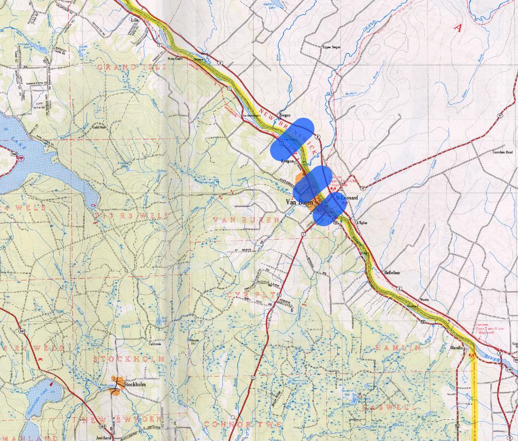
2 2 The second major task of our supplemental work was to review the DEIS corridors for their compatibility with a potential new border crossing in Madawaska and to identify alternative routes, for a new highway connecting Route 11, north of Eagle Lake, with the crossing site(s). The purpose of these new highway connections would be to provide direct trucking access to I-95 via Route 11 from the Canadian border. Ideally, this new connection would maximize the benefits of the significant improvements that MDOT has made to Route 11, and improve freight access to Madawaska (home to Fraser Paper) and the TransCanada Highway (Route 2) (the TransCanada ). The route for the new highway was investigated in three distinct segments: Route 11 to Route 161; Route 161 to 162; and Route 162 to Madawaska/new border crossing This technical memorandum summarizes our preliminary findings. It should be noted that no communications with Canadian officials regarding the location for the border crossing and potential tie in with the TransCanada Highway (Route 2) has occurred. Consultation with the Canadians will be critical to determining the ultimate feasibility of a new border crossing. We assume that a meeting will be scheduled once MDOT has reviewed these preliminary findings. 2.0 METHODOLOGY VHB began the border site selection process and examination of new highway corridors by reviewing available mapping from the ACTS for constraints such as topography, wetlands and s, farmland impacts, Outstanding River Segments, rare species habitat, Section 4(f) properties, historic/archaeological resources, and existing development along the Route 1 east and west of the built up area of Madawaska and in Van Buren. The key environmental factors we considered for the border crossing included and floodway, wetlands, farmlands, and the presence of endangered species. Of particular concern is the Furbishes lousewort (Pedicularis furbishae), a state- and federally-listed endangered species that is known to occur only on the shores of the St. John River. Any new crossing location would have to be investigated for the presence of this species. Note that we have not yet reviewed Canadian environmental constraints (except for obvious constraints observed during site inspections) nor Canadian environmental laws/regulations. A new border crossing was assumed to require approximately 25 acres to accommodate efficient traffic flows (particularly for trucks), inspection areas, control booths, storage areas, administrative facilities, etc on both sides of the border. 1 In addition to topography, the key environmental factors we considered for the highway corridor included wetlands/stream crossings, farmland, rare species habitat, Section 4(f) lands, and land use. Notable constraints within the Study Area for the new corridor include the Fish River, which is an Outstanding River Segment, a large (approximately 1,000 acres) Section 4(f) parcel south of Route 161 owned by the Maine Bureau of Parks and Recreation, and the Northern Aroostook Airport which further constrains the already narrow area available for the corridor to pass through between Long Lake and Route 1. 1 Based upon MDOT studies related to the planned Calais border crossing improvements.
3 3 3.0 CANADIAN BORDER CROSSING REVIEW 3.1 Siting Criteria We looked at two potential areas for a new border crossing into New Brunswick: along Route 1 between Frenchville and Grand Isle, and along Route 1 and Route 1A in Van Buren. Initially, preference was given to the following: sites that offer a shorter, more direct connection to the existing and proposed US transportation network; sites that offer a shorter, more direct bridge and highway connections to the TransCanada Highway; sites nearer to downtown Madawaska and Van Buren (the search extended from Grand Isle to Frenchville for the Madawaska crossing and from the Route 1 and 1A intersection in Van Buren to Keegan for the Van Buren crossing); sites that would be the least disruptive to existing residential and commercial property (and suitably zoned, if applicable); and sites that would have the least environmental/regulatory constraints. Potential sites were more specifically evaluated and screened considering the following criteria: Potential connection to the TransCanada Highway via a new interchange or utilizing existing highways and interchanges Availability of land for a new US customs station (25-acre ± parcel assumed) Availability of land for a new Canadian customs station (25-acre ± parcel assumed) Reasonable bridge length and geometry crossing the St. John River Current land use and development on both sides of the border Proximity and impacts to sensitive environmental and cultural resources 100-year for the St. John River Rail crossing requirements in the US and Canada Based on these criteria, a total of ten potential sites were identified for a crossing: seven in the vicinity of Madawaska and three in Van Buren. These sites are described below and illustrated in Figures 1 and 2. VHB conducted field reviews of the entire border within the Study Area and made site visits at each of the potential sites identified to verify existing conditions and review potential issues related to the St. John River crossing, including bridge alignment and length, highway connections, potential interference with the railroad, etc. The site review was performed by a team consisting of transportation engineers, a structural engineer, and an environmental scientist. An evaluation matrix for the border crossing sites considered is included in Table Madawaska Crossing Site Alternatives Site 1 Frenchville West This site is near Paradis Road in Frenchville (DEIS Corridors C1 and C2). This location has acceptable topography and few environmental constraints. Land use in the area, however, is not as compatible compared with other crossing locations that were reviewed. There are several nearby residential streets and the property between Route 1 and the river is bisected by the railroad, limiting its availability/layout for a Customs facility. This site would be difficult to connect with the TransCanada. The TransCanada approaches Edmunston directly from the north. Therefore any new crossing in Frenchville cannot connect directly with the TransCanada, rather it would have to connect via Route 120. Route 120 is a narrow highway with heavy residential development close to the traveled way in the area just north of Saint Hilaire. To


4 Site 3 r Site 5 nne cto Site 7 Figure 1 Potential Sites Investigated for New Border Crossing Ro ute 11 Co Site 2 Site 1 Site 4 Site 6 C1 C2 Hm Km Miles Source: DeLorme The Maine Atlas and Gazetteer Magis\Gis\06520\Apr\new_concept_corridor
5 2
6 4 accommodate heavy truck traffic, approximately eight miles of Route 120 would need to be upgraded, including one mile within the city limits of Edmundston. Site 2 Frenchville East Between Madawaska and the village area of Frenchville, the area in the vicinity of Route 162 appears to be the most able to accommodate a Customs facility. There is less development in this area and both Route 1 on the US side and Route 120 on the Canadian side are located further from the St. John River, making more land adjacent to the river available for border crossing facilities. The topography on the Canadian side rises rapidly from the river, and would pose a significant problem, particularly as one moves east toward Madawaska. This change in grade (approximately 75 between Route 1 and Route 120) would require a significantly longer and higher bridge crossing and add significantly to the overall projects costs. This site has the same disadvantages as Site 1 in that it would require the upgrade of approximately 7 miles of Route 120 to access the TransCanada Highway. Site 3 West of Fournier Road Two possible sites were located in the vicinity of Fournier Road in Madawaska. The first site would connect into an unnamed gravel road about 0.5 mile west of Fournier Road off Route 1. The area between Route 1 and the St. John River appears large enough to provide 25 acres for a Customs station and is above the 100-year. This site is more developed than Site 4 slightly farther to the east and would affect several homes. The new crossing would need to connect to the TransCanada Highway between the local road overpass over the TransCanada and the grade-separated segment in Saint Basile via a new interchange. The new interchange would be located approximately 1 mile from the nearest interchange. This crossing would require a skewed bridge resulting in a longer crossing. Site 4 Fournier Road This crossing would begin opposite Fournier Road at Route 1 in Madawaska. Between the St. John River and Route 1, there are agricultural fields large enough for a custom station; however, these fields are identified on the FEMA FIRM map as within the 100-year. The FEMA study for Madawaska was an approximate study and no floodway was mapped for the St. John River. Based on our observations, we believe the site is not within the boundary of the floodway, but the elevation of the 100-year flood and the width of the floodway would require confirmation. This site would require upgrading approximately 1.4 miles of Route 1 between the crossing and downtown Madawaska which would also serve to connect it with Corridors Hm and Km from the ACTS. On the Canadian side, there is a narrow band of farm fields that if used for the customs facility could minimize the potential impacts to residential properties. This alternative is close enough to Site 3 such that it would use the same connection with the TransCanada.
7 5 Site 5 - St. David West Site 5 is also in the vicinity of Fournier Road, approximately 1 mile south of Site 4. Route 1 in this area is lined by single-family homes with agricultural fields between them and the river. This crossing could be connected to the ACTS Hm/Km Corridor by traversing the agricultural fields south of Route 1 near Beaulieu Road. The agricultural fields on the east side of Route 1 appear to provide adequate area to locate the Customs facilities; however, similar to Site 4, the floodway location and the 100-year flood elevation will need to be evaluated to assess any impact. The would be at-grade but may require some vertical adjustment of Route 1. On the Canadian side, there appears to be land available for the customs facilities between Route 144 and the railroad, or between the railroad and the river. The floodway and 100-year flood elevation would need to be determined, however, to assess impacts and the viability of locating the custom buildings and parking lots in this area. A connector road through a gravel pit and between two sewage lagoons would be required to connect with the TransCanada in the vicinity of a large barn approximately 2 miles south of Interchange 18. Impacts to this farm as well as agricultural land between Route 144 and the river will be required to complete the crossing connection between Route 1 and the TransCanada. Site 6- St. David East Site 6 is the fourth of the Fournier Road alignments and is located midway between Fournier Road and Beaulieu Road in St. David. Route 1 in this area is lined by single-family homes with agricultural fields between them and the river. This crossing could be connected directly to the ACTS Hm/Km Corridor, which terminates on Route 1 near Beaulieu Road. The agricultural fields on the east side of Route 1 appear large enough to provide adequate area for the Customs facilities. Again, as with Sites 4 and 5, however, the floodway and the 100-year flood elevation will need to be determined. The would be at-grade but may require some vertical adjustment of Route 1. On the Canadian side impacts are the same as discussed for site 5. Site 7 Grand Isle Area Site 7 is located approximately 3 miles east of Site 6, just east of the Route 1 Rest Area. There is a farm field outside the mapped that appears large enough for a new Customs station between the highway and river. There is similar open land on the Canadian side of the river. In addition, there would be few impacts to existing structures on either side of the river as this area is very sparsely developed. A connection with the TransCanada could be accomplished by upgrading approximately 2.5 miles of Route 144, and using the existing TransCanada/Route 144 interchange outside Saint Basile. A disadvantage of this site is its distance from downtown Madawaska which may make it less attractive for trucks going to/from Fraser Paper.
8 6 3.3 Van Buren Crossing Alternatives Site 8 Keegan Site 8 is approximately 3.5 miles northwest of the existing Van Buren border crossing. The crossing site would use an existing railroad log loading area on the US side. The horizontal separation and grade differential between Route 1 and the railroad make a grade separated crossing possible. However, access to the land to be used for the Customs facility would most likely require an at-grade crossing. Observations of the area indicate there is sufficient land available between the river and railroad to meet the needs for the Customs facility which does not appear to be within the. Route 1 would need to be improved to accommodate the increased traffic. A disadvantage of this site is that it would force more truck traffic to travel through Van Buren on its main street unless a bypass route were used. Preliminary investigations indicate that Champlain Road and Castonguay Roads might be suitable for bypass routes, although they would need to be upgraded. On the Canadian side, a wide section of undeveloped land could be used for the customs facility. The roadway would cross Route 144 prior to connection to the TransCanada at a new interchange approximately 2 mile north of Interchange 56. Site 9 - Trans Canada Highway Interchange 56 Connector This site is located approximately 1.5 miles northwest of the existing Van Buren border crossing, just north of an existing (possibly abandoned) railroad bridge. Several residential properties along Route 1 would most likely be affected. There appears to be a narrow area available for the customs facility between the tracks and the river. The would need to be at-grade for this site. Similar to Site 8, this site would also require truck traffic to pass through Van Buren, unless a bypass were developed. On the Canadian side, one or two homes near the river would likely be affected. The route would cross the Canadian rail line using an at-grade crossing prior to crossing Route 144 and connecting into Interchange 56 of the TransCanada. Between the river and the railroad there appears to be sufficient area to accommodate the custom facilities, however, the flooding potential and 100-year flood elevation need would need to be determined. Site 10- US Route One/Canada Route 17 Direct Connection This site is approximately 0.5 miles southeast of the existing border crossing. This site would tie directly into Canadian Route 17 which serves northern New Brunswick, and it would provide a short connection between Route 1 and the TransCanada Highway. In this area, the Route 1 cross section is already designed for truck usage as indicated by the truck climbing lanes southbound out of Van Buren. The available land between Route 1 and the river to accommodate the Customs facilities appears limited. On the Canadian side, there appears to be adequate acreage for a Customs facility between the river and Route 144. However, the would need to be investigated. Some impacts to residential development (2-3 homes) in St. Leonard, New Brunswick would likely occur to construct the roadway that would connect the border crossing with the TransCanada. The TransCanada is two lanes in the crossing area, expanding to a four lane divided highway approximately one mile north of the proposed crossing (between Interchanges 58 and 56). Current highway construction north of the TransCanada indicates that the road will be expanded to a four lane divided highway in the Site 10 crossing area. A bridge over the TransCanada would be required to cross this roadway in order to connect with Route 17. An assessment on interchange and ramp location would need to be made if this site is chosen. The connecting roadway would cross the TransCanada approximately 0.5 mile south of Interchange 58.
9 7 3.4 Border Crossing Recommendation Based upon our preliminary findings, and subject to MDOT review and comment, we find that the border crossing could most easily be established in Van Buren and in particular in the vicinity of Site 10 which would provide a direct connection between Route 1 and both the TransCanada and Route 17, thereby providing access to Quebec and New Brunswick. A new commercial crossing in Van Buren would offer the shortest, most direct route to points within and south of the ACTS Study Area from the St. John Valley. A new border crossing in Van Buren would support the selection of Corridor C-1 or C-2 as the Preferred Corridor in the ACTS and make Corridors Hm and Km less attractive. Of the three Van Buren crossing locations that were looked at, Site 10 offers the best connection with the TransCanada. The site takes advantage of the infrastructure improvements being made by New Brunswick where the TransCanada is being expanded to a 4-lane divided highway. The roadway is already four lanes from Edmundston to within one mile of the proposed connector road at the Site 10 border crossing. This site would connect into the improvements proposed for Route 1 in the ACTS (Corridors C-1and C-2). This crossing location would also help reduce current through truck traffic along Main Street (Route 1) in Van Buren and would not direct as much additional truck traffic along Route 1 as sites 8 & 9 would. Of the crossing sites in Madawaska that were examined, Site 7 appears to be the best option, provided that its distance from downtown Madawaska is deemed to be acceptable. This site would be approximately four miles farther east on Route 1 than Site 5, which also appears feasible, or a total of 7.5 miles east of downtown Madawaska. Thus, it would require a greater amount of upgrading along Route 1. If this distance is unacceptable, then Site 5would become the next most desirable location for a Madawaska crossing. It offers better connections to the TransCanada, more desirable bridge length and geometry, and less disruption to rail crossings than do the Frenchville sites. The next section of this memorandum presents our finding related to the proposal to connect a Madawaska crossing with Route 11.
10 Table 1 Summary Evaluation of New Border Crossing Locations Site Description Connection to TransCanada Madawaska Sites 1 Frenchville (W) 2 Frenchville (E) 3 West of Fournier Road 4 Fournier Road Requires upgrade of 8 +/- miles of Route 120 to Exit 18 Requires upgrade of 7+/- miles of Route 120 to Exit 18 Requires a new interchange to the TransCanada Connection to Route 11 Shortest connection to Route 11 via Route 1 Second shortest connection to Route 11 via Route 1 Connection near Madawaska, but with challenging topography Acreage for US Customs Land area divided by railroad Acreage for Canadian Customs Constrained but probably workable Bridge Length and Geometry Adequate Excellent agricultural use but must cross residential area to access agricultural use, available acreage is within the Moderate crossing (approx foot span) complicated by RR location Long crossing required (approx ft span) at river Skewed bridge crossing. Length will depend upon floodway (approx 1800-ft span). Land Use Canadian Side Residential development along Route 120 to the north Residential development along Route 120 to the north agricultural use with potential for development. Homes would be affected at the new interchange. Land Use US side Residential properties near by agricultural use agricultural use Cultural/ Environmental Resources Rare Species Habitat NHRP Wetland NHRP 4(f) Parcel NHRP Wetlands Maine GIS information not available for this location Maine GIS information not available for this location filling required for approach roadway on each side Rail Crossing (US) Track situated mid-way between Route 1 and River Route 11 Connector must span Route 1 and railroad Potential for grade-separated Rail Crossing (Canada) No railway on Canadian side No railway on Canadian side No railway on Canadian side 5 St. David West Requires a new interchange to the TransCanada Direct connection to TransCanada 1.5 miles southeast of interchange 26 Connection near Madawaska but with challenging topography Connection near Madawaska but with challenging topography agricultural use, available acreage is within the agricultural use, available acreage is within the agricultural use, available acreage is within the agricultural use, available acreage is within the Final Length will depend upon floodway determination (approx ft span) Final Length will depend upon floodway determination (approx. 2,000-ft to 2,500-ft span) agricultural use with potential for development. Homes would be affected at the new interchange. Agriculture agricultural use but within 100-year Agriculture Wetland filling required for US customs and approach roadway on each side Maine GIS information not available for this location Requires at-grade Requires at-grade No railway on Canadian side No railway on Canadian side Mawatr\ev\06520\docs\memos\Madawaska_Border Crossing Recommendation Tech memo.doc
11 9 Table 1 Summary Evaluation of New Border Crossing Locations Connection to Site Description TransCanada 6 St. David East 7 Grand Isle Direct connection to TransCanada 1.5 miles southeast of interchange 26 Connection to Route 11 Connection near Madawaska but with challenging topography Acreage for US Customs fair agricultural use, available acreage is within the Acreage for Canadian Customs agricultural use, available acreage is within the Bridge Length and Geometry Final Length will depend upon floodway determination (approx. 2,000-ft to 2,500-ft span) Land Use Canadian Side Agriculture Land Use US side Agriculture Cultural/ Environmental Resources Maine GIS information not available for this location Rail Crossing (US) Requires at-grade Rail Crossing (Canada) No railway on Canadian side Van Buren Sites 8 Keegan 9 TransCanada Highway Interchange 56 Connector 10 US Route One/Canada Route 17 Direct Connection Connection via rural section of Route 144 and an existing interchange for the TransCanada Requires new interchange 2 miles northwest of the Trans Canada Highway This route would tie directly into interchange 56 New road would go over the TransCanada and connect at Route 17 Requires an additional 5 miles of roadway compared to a connection in Madawaska N/A N/A N/A agricultural use Existing railroad log loading area Residential impacts may occur in Van Buren Space between St. John and Route 1 limited, land acquisition required forested and agricultural use Undeveloped forested upland Adequate space but may impact two residential properties Adequate acreage on the Canadian side for customs facilities Shortest crossing location (approx. 800-ft span) Long crossing (approx. 2,500 ft span) complicated by railroad crossing on Canadian side, span may be able to use small islands in river Moderate crossing (approx. 1,100 ft) complicated by on both sides of the river Long crossing (approx. 2,500 ft) complicated on Canadian side by and floodway = Outstanding River Segment = Deer Wintering Area NHRP = National Historic Register Property 4(f)/6(f) = Location of Potential 4(f) and/or 6(f) Parcel Less Than 130 Acres Abandoned weigh station at tie in to Route 144. Little development on Route 144 to the TransCanada interchange Undeveloped forested upland Potential impacts to two residential properties Residential properties will be impacted by roadway forested and agricultural use Railroad log loading area Potential impacts to multiple residential properties Land acquisition required for vacant lots of limited size Wetland Wetland Wetland 4(f)/6(f) Narrow in this area Maine GIS information not available for this location Maine GIS information not available for this location Maine GIS information not available for this location Requires at-grade Requires at-grade At-grade crossing is the only viable alternative Requires at-grade At-grade crossing preferred. Bridge over railroad would require raising the profile on Route 144. At grade crossing required for access to Canadian customs facilities At grade crossing required for access to Canadian customs facilities At grade crossing required for access to Canadian customs facilities
12 ALTERNATIVE HIGHWAY CONCEPT DEVELOPMENT VHB developed a new highway corridor alternative to connect a border crossing just east of Madawaska to the US and Canadian highway network. Specifically, VHB laid out a corridor (approximately 1,000 feet wide), to better connect the crossing to the TransCanada Highway with Routes 11, 161 and 162. This corridor alternative is shown in Figure 1 as described by segment below. 4.1 Route 11 in Wallagrass to Route 161 in Daigle The constraints for this segment of the corridor include the northern end of Eagle Lake, crossing the Fish River (an Outstanding River Segment), rolling terrain, agricultural land use, and isolated wetlands. To fit within these constraints, this segment of new highway begins in Wallagrass approximately one mile north of the Wallagrass/Eagle Lake town line. It crosses the Bangor & Aroostook Railroad and the Fish River approximately one mile south of Soldier Pond. The highway link then continues northeast towards Route 161 crossing Sly Brook Road, Lamarre Road, Ayotte Road, and Fox Road, finally intersecting Route 161 in Daigle about 0.5 mile west of Daigle Pond. The corridor would then follow Route 161 east for approximately three miles. 4.2 Route 161 in Daigle to Route 162 in Saint Agatha The constraints for this segment include Daigle Pond, a large wetlands complex south of Route 161, rolling terrain, agricultural land use, and isolated wetlands north of Route 161. This segment, as a result, starts approximately two miles north of the intersection of Route 161 and Caribou Road or about 2.5 miles south of Daigle in T17 R5. This highway segment heads northeast to the intersection of Fourth Row Road with Bourgoin Avenue, then Third Row Road, and Second Row Road at Marquis Road. From Second Row Road, the corridor follows Marquis Road north until it ends at Hillside Road. The corridor continues straight from the end of Marquis Road to Route 162 in Saint Agatha. 4.3 Route 162 in Saint Agatha to Route 1 in Madawaska This new highway segment would have a number of constraints to avoid in order to connect with Route 1, including the Northern Aroostook Regional Airport, rare species habitat, rolling terrain, agricultural land use, and residential development along Route 1. The topography near Route 1 in Madawaska is the most significant constraint as it may be impossible to find a feasible route for the corridor that does not exceed 8 percent grades. The proposed alignment was chosen to minimize grades, however, grades in excess of 8 percent could not be completely avoided. This segment of the corridor begins at the intersection of Route 162 in the vicinity of Marquis Road. The corridor continues north, intersecting Cleveland Avenue and Airport Road just west of the Northern Aroostook Airport (the corridor should not impact the airport). The link continues northeast intersecting Dionne Road, Gagnon Road, and Dufour Road. The corridor then meets Fournier Road and follows it more than ½ mile to Route 1 in Madawaska. Mawatr\ev\06520\docs\memos\Madawaska_Border Crossing Recommendation Tech memo.doc
13 11 Table 2 presents preliminary findings of the anticipated impacts for the connector highway described above. The highway would have substantial wetland impact (28 acres) and would affect approximately 14 acres of prime farmland. Table 2 Key Environmental Constraints- Route 11 Connector Corridor Segment Aquatic Habitat Wetlands Upland Forest Community Prime Farmland Soils Wading Bird Habitat Streams Rivers Ponds ha ac ha ac ha ac ha ac Route 1 to Rt 161* Upgrade Route 161** Route 161 to Route 11* Total * Based on 300-foot wide corridor ** Based on 150-foot wide corridor Table 3 presents a comparison of the transportation benefits of the connector highway compared with the use of the existing highways and corridor C1/C2 in the ACTS. Table 3 Route 11 Connection Options Connection Options Distance (miles) Approximate Travel Time (minutes) Route 11* to Border Crossing** via Route 11 and Route 1 Route 11* to Border Crossing** via entirely New Highway Corridor Route 161*** to Madawaska**** via Corridor C1/C2 and Route 1 Route 161*** to Madawaska via Corridor C1/C2 and New Highway Corridor and Route * Beginning in Wallagrass Plantation, just north of Eagle Lake, where proposed Route 11 Connector would intersect Route 11. ** Border Crossing location near Fournier Road off of Route 1 *** Beginning at C1/C2 intersection with Route 161 **** Madawaska downtown. A comparison of the travel time with and without the connector indicate that if the new connector was built, it would save approximately 10 minutes between Route 11 and the border crossing, and 3 minutes between Route 161 and Madawaska.
14 NEXT STEPS If MDOT agrees with the findings presented in this Technical Memorandum, VHB will proceed with a number of additional steps to further advance and refine a concept for the border crossing and highway connection with Route 1 and the TransCanada. These include the following: Coordinate meeting with Canadian transportation officials, and US and Canadian Customs officials, to obtain their feedback concerning the crossing location and connection with the TransCanada. Begin conceptual layouts for the new bridge and connection with Route 1 and the TransCanada, including alternative interchange configurations. Begin conceptual layouts for customs facilities at selected site. Prepare a Technical Memorandum regarding additional findings.
MAIN POINTS OF PRESENTATION BY RUTH BONSIGNORE, JON FEINSTEIN AND TONY GRANDE, VHB
 Maine Department of Transportation Aroostook County Transportation Study Public Advisory Committee (PAC) Meeting Minutes PAC Meeting No. 22 Tuesday, March 16 th, 2004 Caribou Inn and Convention Center
Draft Concept Alternatives Analysis for the Inaugural Airport Program September 2005
 Section 10 Preferred Inaugural Airport Concept 10.0 Introduction The Preferred Inaugural Airport Concept for SSA was developed by adding the preferred support/ancillary facilities selected in Section 9
FEASIBILITY CRITERIA
 This chapter describes the methodology and criteria used to evaluate the feasibility of developing trails throughout the study areas. Land availability, habitat sensitivity, roadway crossings and on-street
Draft Concept Alternatives Analysis for the Inaugural Airport Program September 2005
 Draft Concept Alternatives Analysis for the Inaugural Airport Program September 2005 Section 3 - Refinement of the Ultimate Airfield Concept Using the Base Concept identified in Section 2, IDOT re-examined
Lake Erie Commerce Center Traffic Analysis
 LOCATION: East of NYS Route 5 at Bayview Road Town of Hamburg Erie County, New York PREPARED BY: Wendel Companies 140 John James Audubon Parkway Suite 200 Amherst, New York 14228 January 2012 i ii Table
Alternatives Study of Alignment
 Project: 4-lanning of Barhi Rajauli Section of NH-31 Sheet: 1 of 6 Alternatives Study of Alignment 1 Objectives The following objectives were kept in view while locating the alternative bypass alignments:
CHAPTER FOUR AIRPORT ALTERNATIVES
 4.0 INTRODUCTION CHAPTER FOUR The goal of the master planning process is to provide the City of New Smyrna Beach with an assessment of the adequacy and capabilities of the Airport as well as to identify
AGENDA ITEM 5 D WAKULLA ENVIRONMENTAL INSTITUTE (WEI) TRAIL FEASIBILITY STUDY
 TRAIL FEASIBILITY STUDY") March 19, 2018 AGENDA ITEM 5 D WAKULLA ENVIRONMENTAL INSTITUTE (WEI) TRAIL FEASIBILITY STUDY TYPE OF ITEM: Action STATEMENT OF ISSUE The Wakulla Environmental Institute (WEI) Trail is one of several trails
March 19, 2018 AGENDA ITEM 5 D WAKULLA ENVIRONMENTAL INSTITUTE (WEI) TRAIL FEASIBILITY STUDY TYPE OF ITEM: Action STATEMENT OF ISSUE The Wakulla Environmental Institute (WEI) Trail is one of several trails
C. APPROACH FOR IDENTIFYING THE BEST ROUTES FOR THE NEEDED TRANSMISSION SYSTEM IMPROVEMENTS
 C. APPROACH FOR IDENTIFYING THE BEST ROUTES FOR THE NEEDED TRANSMISSION SYSTEM IMPROVEMENTS CL&P s approach for identifying the best routes for the needed transmission system improvements included a determination
THE ALBERTA GAZETTE, SEPTEMBER
 VILLAGE OF CEREAL Order No. 16915 IN THE MATTER OF THE "Municipal Government Act": File No. 241(A)3 AND IN THE MATTER OF an application by the Council of the Village of Cereal, in the Province of Alberta,
FNORTHWEST ARKANSAS WESTERN BELTWAY FEASIBILITY STUDY
 FNORTHWEST ARKANSAS WESTERN BELTWAY FEASIBILITY STUDY EXECUTIVE SUMMARY The 2030 Northwest Arkansas Regional Transportation Plan developed by the Northwest Arkansas Regional Planning Commission (NWARPC)
Airport Planning Area
 PLANNING AREA POLICIES l AIRPORT Airport Planning Area LOCATION AND CONTEXT The Airport Planning Area ( Airport area ) is a key part of Boise s economy and transportation network; it features a multi-purpose
Appendix F International Terminal Building Main Terminal Departures Level and Boarding Areas A and G Alternatives Analysis
 Appendix F International Terminal Building Main Terminal Departures Level and Boarding Areas A and G Alternatives Analysis ITB MAIN TERMINAL DEPARTURES LEVEL & BOARDING AREAS A & G ALTERNATIVES ANALYSIS
Stage 2 ION: Light Rail Transit (LRT) from Kitchener to Cambridge
 from Kitchener to Cambridge") Stage 2 ION: Light Rail Transit (LRT) from Kitchener to Cambridge Public Consultation Centre (PCC) No. 3 Please Sign-in Cambridge City Hall November 21, 2017 2:00 to 8:00pm Preston Memorial Auditorium
Stage 2 ION: Light Rail Transit (LRT) from Kitchener to Cambridge Public Consultation Centre (PCC) No. 3 Please Sign-in Cambridge City Hall November 21, 2017 2:00 to 8:00pm Preston Memorial Auditorium
At the time, the portion of the line through Eagle County remains wholly under the ownership of Union Pacific Railroad (UP).
.") Chapter 5 The Railroad Corridor as a Trail Corridor The intent of this chapter is to identify how the rail corridor, if available for lease or purchase in all or part, could be incorporated into the core
Chapter 5 The Railroad Corridor as a Trail Corridor The intent of this chapter is to identify how the rail corridor, if available for lease or purchase in all or part, could be incorporated into the core
HAMPTON ROADS CROSSINGS PATRIOTS CROSSING AND HRBT
 HRTPO Board Meeting March 21, 2013 Agenda ITEM #9: HAMPTON ROADS CROSSINGS PATRIOTS CROSSING AND HRBT Congestion at the Hampton Roads Bridge-Tunnel (HRBT) on I-64 has long been identified as a problem
Stage 2 - November 2017 Survey and Map Comments (verbatim)
") Stage 2 - November 2017 Survey and Map Comments (verbatim) Identifying information removed to meet Freedom of Information and Protection of Privacy Act (FOIP Act). Comments are recorded exactly as they
Stage 2 - November 2017 Survey and Map Comments (verbatim) Identifying information removed to meet Freedom of Information and Protection of Privacy Act (FOIP Act). Comments are recorded exactly as they
Macleod Trail Corridor Study. Welcome. Macleod Trail Corridor Study Open House. Presentation of Proposed Design Concepts
 Macleod Trail Corridor Study Welcome Macleod Trail Corridor Study Open House Presentation of Proposed Design Concepts Study Purpose Develop a corridor plan for Macleod Trail that aligns with The City s:
Chapter 4.0 Alternatives Analysis
 Chapter 4.0 Alternatives Analysis Chapter 1 accumulated the baseline of existing airport data, Chapter 2 presented the outlook for the future in terms of operational activity, Chapter 3 defined the facilities
FHWA P/N Guidelines. Corridor Relationship. Highway 22 Segment 1 - US 169 to CSAH 2 Relevance / Documentation of Need
 Highway 22 Segment 1 - US 169 to CSAH 2 Vehicle Mobility Congestion Intersection Congestion Existing Conditions - Based on Highway Capacity Manual methodology, corridor level of service is currently LOS
Preliminary Site Evaluation
 Preliminary Site Evaluation 100 Acre Site, US 72 Piperton, Tennessee Power Distributor: Chickasaw Electric Cooperative August 2010 SITE DATA SHEET PIPERTON US 72 SITE (100 ACRES): LOCATION & GENERAL DESCRIPTION
Engagement Summary Report. Trans-Canada Highway 1 RW Bruhn Bridge Replacement Project. Community Engagement November 15, 2016 to January 15, 2017
 Trans-Canada Highway 1 RW Bruhn Bridge Replacement Project Community Engagement November 15, 2016 to January 15, 2017 Engagement Summary Report February 2017 Prepared by Kirk & Co. Consulting Ltd. Trans-Canada
Bradley Brook Relocation Project. Scoping Notice. Saco Ranger District. United States Department of Agriculture Forest Service
 Bradley Brook Relocation Project United States Department of Agriculture Forest Service Scoping Notice White Mountain National Forest February 2011 For Information Contact: Jenny Burnett White Mountain
SUMMER VILLAGE OF SILVER SANDS. Municipal Development Plan
 SUMMER VILLAGE OF SILVER SANDS Municipal Development Plan Bylaw 253-2014 Adopted August 22, 2014 Summer Village of Silver Sands Municipal Development Plan Bylaw No. 253-2014 Page 2 1 INTRODUCTION 1.1 SETTING
WELCOME US 83 Public Meeting
 WELCOME US 83 Public Meeting From north of the Starr/Zapata County Line to Loma Blanca Road Thursday, June 8, 2017 Roma Middle School Lecture Hall Open House: 5 6 p.m. Presentation and Public Comment:
SECTION 5 ALTERNATIVE DEVELOPMENT CONCEPT ANALYSES
 SECTION 5 ALTERNATIVE DEVELOPMENT CONCEPT ANALYSES 5.1 INTRODUCTION This section investigates Airfield Development Alternatives, generalized Land Use Alternatives, and more detailed General Aviation Alternatives.
CHAPTER 4: ALTERNATIVES
 MSP Long Term Comprehensive Plan Update Metropolitan Airports Commission 4.1 INTRODUCTION CHAPTER 4: ALTERNATIVES Several alternatives were developed and evaluated based on their capability to meet the
White Mountain National Forest Saco Ranger District
 United States Department of Agriculture Forest Service White Mountain National Forest Saco Ranger District 33 Kancamagus Highway Conway, NH 03818 Comm: (603) 447-5448 TTY: (603) 447-3121 File Code: 1950
US 380 FEASIBILITY STUDY
 US 380 FEASIBILITY STUDY Denton County CSJ(s): 0135-10-061, 0135-10-062 Public Meeting(s): January 15 & 22, 2019 WELCOME US 380 Denton County Feasibility Study DALLAS DISTRICT PUBLIC MEETING January 15
US 83 FROM NORTH OF THE STARR/ZAPATA COUNTY LINE TO LOMA BLANCA ROAD
 US 83 FROM NORTH OF THE STARR/ZAPATA COUNTY LINE TO LOMA BLANCA ROAD PUBLIC MEETING JUNE 8, 2017 Talk Text Crash 2 AGENDA TECHNICAL PRESENTATION (Roma Area Engineer Eduardo Gracia, P.E.) PROJECT SCHEDULE
PSP 75 Lancefield Road. Northern Jacksons Creek Crossing Supplementary Information
 PSP 75 Lancefield Road Northern Jacksons Creek Crossing Supplementary Information September 2017 The northern crossing of Jacksons Creek proposed within the Lancefield Road PSP is a key part of the ultimate
Rule Governing the Designation and Establishment of All-Terrain Vehicle Use Trails on State Land
 Rule Governing the Designation and Establishment of All-Terrain Vehicle Use Trails on State Land 1.0 Authority 1.1 This rule is promulgated pursuant to 23 V.S.A. 3506. Section 3506 (b)(4) states that an
A. CONCLUSIONS OF THE FGEIS
 Chapter 11: Traffic and Parking A. CONCLUSIONS OF THE FGEIS The FGEIS found that the Approved Plan will generate a substantial volume of vehicular and pedestrian activity, including an estimated 1,300
Georgetown-Lewes Rail/Trail Study. Rail/Trail Study: Cool Spring to Cape Henlopen State Park New Road Extension (House Resolution No.
 Georgetown-Lewes Rail/Trail Study Rail/Trail Study: Cool Spring to Cape Henlopen State Park New Road Extension (House Resolution No. 47) August 22, 2011 Presentation Outline Background Benefits Statewide
1.2 Corridor History and Current Characteristics
 SECTION 1 Description and Background of Study Area 1.1 Introduction This preliminary engineering report was prepared for the Alaska Department of Transportation and Public Facilities (ADOT&PF). It is part
Bloor Street West Rezoning Application for a Temporary Use By-law Final Report
 STAFF REPORT ACTION REQUIRED 3741 3751 Bloor Street West Rezoning Application for a Temporary Use By-law Final Report Date: June 12, 2007 To: From: Wards: Reference Number: Etobicoke York Community Council
BOSTON REGION METROPOLITAN PLANNING ORGANIZATION
 PLANNING ORGANIZATIO BOSTON REGION MPO NMETROPOLITAN BOSTON REGION METROPOLITAN PLANNING ORGANIZATION Stephanie Pollack, MassDOT Secretary and CEO and MPO Chair Karl H. Quackenbush, Executive Director,
3. COLTA / HUGA CONNECTIONS - PRELIMINARY
 9 3. COLTA / HUGA CONNECTIONS - PRELIMINARY 3.1 COLTA The Chain of Lakes Trail Association (COLTA) trail, formerly identified as the Chester Spur Line, was completed and opened for use in June 2011. The
THOMAS A. SWIFT METROPARK Introductions History Present Conditions Future Development Plans Implementation Strategies Statistics
 THOMAS A. SWIFT METROPARK Introductions History Present Conditions Future Development Plans Implementation Strategies Statistics Introduction As an open meadow park positioned along the Mahoning River,
1803 West Hwy 160 Monte Vista, CO (719) TTY (719)
 TTY (719)") USDA Forest Service Rio Grande National Forest http://www.fs.fed.us/r2/riogrande 1803 West Hwy 160 Monte Vista, CO 81144 (719)852-5941 TTY (719)852-6271 USDI Bureau of Land Management San Luis Valley Center
USDA Forest Service Rio Grande National Forest http://www.fs.fed.us/r2/riogrande 1803 West Hwy 160 Monte Vista, CO 81144 (719)852-5941 TTY (719)852-6271 USDI Bureau of Land Management San Luis Valley Center
APPENDIX 3-I-B. Alternative Route Assessment Around Provincial Parks and Conservation Reserves
 EAST-WEST TIE TRANSMISSION PROJECT ENVIRONMENTAL ASSESSMENT REPORT APPENDIX 3-I-B Alternative Route Assessment Around Provincial Parks and Conservation Reserves Report No. 1536607/2000/2018 TABLE OF CONTENTS
A number of goals were identified during the initial work on this Big Lake Transportation Plan.
 C. Transportation General Background Information Big Lake s transportation system includes all the roads, paths and facilities that allow the movement of private vehicles, trains and planes, as well as
Chuckanut Ridge Fairhaven Highlands EIS Scoping Concerns
 Chuckanut Ridge Fairhaven Highlands EIS Scoping Concerns Coalition of Southside Neighborhoods CSN Comments for Fairhaven Highlands EIS Scope Hearing, Jan 16, 2008 1 Chuckanut Ridge Hilly Terrain: Potential
DRAFT - APRIL 13, 2007 ROUTING STUDY FOR TRAIL CONNECTIONS BETWEEN CALAIS AND AYERS JUNCTION
 DRAFT - APRIL 13, 2007 ROUTING STUDY FOR TRAIL CONNECTIONS BETWEEN CALAIS AND AYERS JUNCTION Abstract The vision for the East Coast Greenway is an off-road urban trail system running from Calais, Maine
4. Safety Concerns Potential Short and Medium-Term Improvements
 NH Route 104 Access Management Study Page 19 4. Safety Concerns Potential Short and Medium-Term Improvements Potential safety improvement strategies are listed by priority based on field observations by
Sudbury to Hudson Transmission Reliability Project
 An independent assessment of routing options Sudbury to Hudson Transmission Reliability Project and use of a rail-banked corridor for this purpose Prepared by: NorthEast Logistics Systems, LLC August 29,
United States Department of the Interior National Park Service. Boundary Expansion Listed in National Register January 11, 2017
 NPS Form 10900-a (Rev. 8/2002) OMB No. 10240018 United States Department of the Interior National Park Service Boundary Expansion Listed in National Register January 11, 2017 National Register of Historic
THE AIRTRAIN AIRPORT ACCESS SYSTEM JOHN F. KENNEDY INTERNATIONAL AIRPORT AIRPORT ACCESS SERVICE
 THE AIRTRAIN AIRPORT ACCESS SYSTEM JOHN F. KENNEDY INTERNATIONAL AIRPORT AIRPORT ACCESS SERVICE The JFK AirTrain airport access system interfaces with two existing regional transit systems; the Long Island
Business Growth (as of mid 2002)
") Page 1 of 6 Planning FHWA > HEP > Planning > Econ Dev < Previous Contents Next > Business Growth (as of mid 2002) Data from two business directories was used to analyze the change in the number of businesses
Page 1 of 6 Planning FHWA > HEP > Planning > Econ Dev < Previous Contents Next > Business Growth (as of mid 2002) Data from two business directories was used to analyze the change in the number of businesses
EXECUTIVE SUMMARY PROGRAM DEVELOPMENT REPORT PURPOSE EXISTING SETTING EXPANDING PARKLAND
 EXECUTIVE SUMMARY PROGRAM DEVELOPMENT REPORT PURPOSE As the culmination of the first phase of the master planning process, this Program Development Report creates the framework to develop the Calero County
November 11, 2009 BY . Planning and Growth Management Department 110 Laurier Avenue West, 4 th Floor Ottawa, Ontario K1P 1J1. Dear Mr.
 November 11, 2009 Planning and Growth Management Department 110 Laurier Avenue West, 4 th Floor Ottawa, Ontario K1P 1J1 BY E-MAIL Attention: Mr. Don Herweyer Dear Mr. Herweyer: Reference: Abbott-Fernbank
White Mountain National Forest
 White Mountain National Forest United States Department of Agriculture Forest Service Eastern Region Boles Brook Snowmobile Bridge Decision Memo Boles Brook Snowmobile Bridge Project Town of Woodstock
Other Principle Arterials Minor Arterial Major Collector Minor Collector Local
 CHAPTER 10 TRANSPORTATION Introduction The system of public roads in East Pikeland Township is decidedly rural in character. Since the 1984, the road network has remained much the same, with the addition
FEDERAL HIGHWAY ADMINISTRATION NEVADA DEPARTMENT OF TRANSPORTATION ENVIRONMENTAL IMPACT STATEMENT RE-EVALUATION
 FEDERAL HIGHWAY ADMINISTRATION NEVADA DEPARTMENT OF TRANSPORTATION ENVIRONMENTAL IMPACT STATEMENT RE-EVALUATION Project Name: Boulder City/US 93 Corridor Study (Boulder City Bypass) Project Location: The
Spencer Environmental Appendix A: Alternative Analysis for Construction Access Route
 Spencer Environmental Appendix A: Alternative Analysis for Construction Access Route February 2015 Valley ine-stage 1 RT EISA Update FINA REPORT Page A1 Memorandum AECOM ConnectEd Transit Partnership 10235
With the first portion of this process complete, we anticipate the general timeline for the remainder of the process to be:
 THE CITY OF FIRE RESCUE E D M O N T O N FIRE RESCUE SERVICES 10351 96 Street Edmonton, Alberta T5H 2H5 April 19, 2013 Dear Rossdale residents: As many of you know, Fire Rescue Services is currently in
FEASIBILITY STUDY. holdings SEPTEMBER 13, prepared for: prepared by:
 FEASIBILITY STUDY SEPTEMBER 13, 2013 prepared for: holdings prepared by: Table of Contents Project Feasibility... 3 Project Background... 4 Project and Community Context... 5 Site constraints... 6 Statement
Treaty Oaks Ranch 323+/- Acres Hood County, Texas $1,776,500
 Bret Polk Mobile: (254) 965-0349 Office: (214) 361-9191 Treaty Oaks Ranch 323+/- Acres Hood County, Texas $1,776,500 LOCATION: The ranch is located in a desirable area 10+/- miles south of Granbury, Texas,
Sawtooth National Forest Fairfield Ranger District
 United States Department of Agriculture Forest Service Sawtooth National Forest Fairfield Ranger District P.O. Box 189 Fairfield, ID. 83327 208-764-3202 Fax: 208-764-3211 File Code: 1950/7700 Date: December
Executive Summary. MASTER PLAN UPDATE Fort Collins-Loveland Municipal Airport
 Executive Summary MASTER PLAN UPDATE Fort Collins-Loveland Municipal Airport As a general aviation and commercial service airport, Fort Collins- Loveland Municipal Airport serves as an important niche
Site Location and Setting
 Memorandum Date: To: From: Subject: Kristy Le, Gary Black Steve Orem Santa Teresa County Park Historic Area Traffic and Parking Study Hexagon Transportation Consultants, Inc. has completed a traffic and
David Johnson. Tom, Attached please find the final scoping letter and figures for your review. David
 David Johnson From: Sent: To: Cc: Subject: Attachments: David Johnson Tuesday, April 12, 2011 4:33 PM Thomas Malecek Dave Dyer; Jason Marks (jmarks@segroup.com) VWC Scoping Letter
Town of Oakfield Agricultural and Farmland Protection Plan
 SECTION III COMMUNITY OVERVIEW A. Regional Setting / Location The Town of Oakfield is located in the northwestern portion of Genesee County. Located west of New York's Finger Lakes, the Town is uniquely
Mt. Hood National Forest
 United States Department of Agriculture Forest Service Mt. Hood National Forest Zigzag Ranger District 70220 E. Highway 26 Zigzag, OR 97049 503-622-3191 Fax: 503-622-5622 File Code: 1950-1 Date: June 29,
Section II. Planning & Public Process Planning for the Baker/Carver Regional Trail began in 2010 as a City of Minnetrista initiative.
 Section II Planning & Public Process Planning for the began in 2010 as a City of initiative. city staff began discussions with the Park District on the possibility of a north/south regional trail connection
PROGRESS PARK CONNECTOR
 PROGRESS PARK CONNECTOR Project No. 9999 098 R65, P102 ALTERNATIVES ANALYSIS 6 April 2015 Revised for updated dates PROGRESS PARK CONNECTOR ROAD ALTERNATIVES ALTERNATIVE # 1 West from the intersection
Mountain Valley Pipeline, LLC Mountain Valley Pipeline Project Docket No. CP
 16. Prior to construction, Mountain Valley shall file with the Secretary, for review and approval by the Director of OEP, a segment-specific construction and operation access plan for the area between
Longmont to Boulder Regional Trail Jay Road Connection DRAFT FINAL REPORT
 Longmont to Boulder Regional Trail Jay Road Connection DRAFT FINAL REPORT December 2018 Project Summary Boulder County, Colorado, in partnership with the City of Boulder, is evaluating options for multi-use
The Transportation Corridor Overlay District
 The Transportation Corridor Overlay District The Transportation Corridor Overlay District is a policy framework under which certain potentially beneficial development proposals may be considered, given
MONTEREY REGIONAL AIRPORT MASTER PLAN TOPICAL QUESTIONS FROM THE PLANNING ADVISORY COMMITTEE AND TOPICAL RESPONSES
 MONTEREY REGIONAL AIRPORT MASTER PLAN TOPICAL QUESTIONS FROM THE PLANNING ADVISORY COMMITTEE AND TOPICAL RESPONSES Recurring topics emerged in some of the comments and questions raised by members of the
SOUTH INTERCHANGE AREA
 Santaquin City General Plan 1 Location and Characteristics The South Interchange Area of Santaquin is located west of Interstate 15 and south of 500 South (Figure 1). It includes properties already annexed
EAST DON TRAIL ENVIRONMENTAL ASSESSMENT. Community Liaison Committee Meeting #3 July 15, :30 to 8:30 pm Flemingdon Park Library
 EAST DON TRAIL ENVIRONMENTAL ASSESSMENT Community Liaison Committee Meeting #3 July 15, 2013 6:30 to 8:30 pm Flemingdon Park Library Agenda 1. Welcome 2. Housekeeping and Updates a) Housekeeping b) CLC
Alternatives Development and Evaluation Report
 Airport Master Plan Alternatives Development and Evaluation Report Prepared by: AECOM Prepared for: Illinois Department of Transportation December 16, 2011 Table of Contents Topic Page Number Cover Sheet...
Chapter 4. Development Alternatives
 Chapter 4. Development Alternatives Chapter 4. DEVELOPMENT ALTERNATIVES This chapter identifies and evaluates airport development alternatives to fulfill the facility requirements for the airport as defined
Pattullo Bridge Replacement Project
 Pattullo Bridge Overview This document will: Explain the challenges facing the Pattullo Bridge today Share how we propose moving forward translink.ca PAGE 1 History By Order of the Lieutenant Governor
A. From I-68 in Monongalia County, West Virginia to SR 6119 in Fayette County, Pennsylvania 1
 Mon-Fayette Transportation Project A. From I-68 in Monongalia County, West Virginia to SR 6119 in Fayette County, Pennsylvania 1 The Mon/Fayette Transportation Project (MFTP) from I-68 in West Virginia
Segment 2: La Crescent to Miller s Corner
 goal of the USFWS refuges is to conserve, protect and enhance fish, wildlife and plants and their habitats for the continuing benefit of the American people. Refuge lands are used largely for fishing,
Draft Concept Alternatives Analysis for the Inaugural Airport Program September 2005
 Draft Concept Alternatives Analysis for the Inaugural Airport Program September 2005 Section 1 - Introduction This report describes the development and analysis of concept alternatives that would accommodate
STAFF REPORT TO COUNCIL
 i CITYOF PRINCE GEORGE STAFF REPORT TO COUNCIL 1100 Patricia Blvd. I Prince George, BC, Canada V2L 3V9 I www.pri ncegeorge.ca DATE: January 24, 2017 TO: NAME AND TITLE: SUBJECT: MAYOR AND COUNCIL Dave
ALBANY-HUDSON ELECTRIC TRAIL FEASIBILITY STUDY. Final Report OCTOBER 2011
 ALBANY-HUDSON ELECTRIC TRAIL FEASIBILITY STUDY Final Report OCTOBER 2011 ALBANY-HUDSON ELECTRIC TRAIL FEASIBILITY STUDY Prepared for: Town of East Greenbush 225 Columbia Turnpike Rensselaer, New York 12144
PULLMAN-MOSCOW REGIONAL AIRPORT Runway Realignment Project
 PULLMAN-MOSCOW REGIONAL AIRPORT Runway Realignment Project GENERAL AIRPORT INFORMATION AIRPORT USERS Airport ownership: Public, owned by the Pullman-Moscow Regional Airport Board Year opened: February
The San Diego Region s Air Transportation Future
 The San Diego Region s Air Transportation Future June 22, 2006 1 Ryan N. Hall, Airport System Planner II San Diego County Regional Airport Authority Presentation Overview 1. The law 2. The ballot measure
This section evaluates the projected traffic operations and circulation impacts associated with the proposed upgrade and expansion of the LWRP.
 4.5 TRAFFIC AND CIRCULATION This section evaluates the projected traffic operations and circulation impacts associated with the proposed upgrade and expansion of the LWRP. 4.5.1 Environmental Setting Existing
Public Notice ISSUED: December 10, 2018 EXPIRES: January 9, 2019
 APPLICANT: REFER TO: St. Louis and Lake Counties Regional Rail Authority 2018-01942-ARC Public Notice ISSUED: December 10, 2018 EXPIRES: January 9, 2019 SECTION:404 - Clean Water Act 1. APPLICATION FOR
Airport Master Plan Update June 15, 2017
 Airport Master Plan Update June 15, 2017 www.harveyfield.com The Master Plan is a 20-year plan to understand the needs of current and future users of the Airport. This is important to ensure that safe
VRE Manassas Park Station Parking Expansion Alternatives Analysis
 VRE Manassas Park Station Parking Expansion Alternatives Analysis Summary Report September 18, 2017 THIS PAGE INTENTIONALLY LEFT BLANK Table of Contents 1.0 Introduction... 1 2.0 Summary of Existing Conditions...3
MEMORANDUM. Lynn Hayes LSA Associates, Inc.
 MEMORANDUM To: Lynn Hayes LSA Associates, Inc. Date: May 5, 217 From: Zawwar Saiyed, P.E., Senior Transportation Engineer Justin Tucker, Transportation Engineer I Linscott, Law & Greenspan, Engineers LLG
Spadina Avenue Built Form Study Preliminary Report
 STAFF REPORT ACTION REQUIRED Spadina Avenue Built Form Study Preliminary Report Date: July 9, 2014 To: From: Wards: Reference Number: Toronto and East York Community Council Director, Community Planning,
Abbey Chesterton bridge Questions & Answers
 Abbey Chesterton bridge Questions & Answers Please click on links below to go to individual subjects: Bridge location and access routes Timescales Bridge details and accessibility Construction compound
Attachment G STREAM IMPACTS. Ridge Road Extension Alternatives Analysis
 Attachment G STREAM IMPACTS for: Ridge Road Extension Alternatives Analysis PREPARED FOR: Pasco County Engineering Services Department PREPARED BY: NV5, INC. 6989 E. FOWLER AVENUE TAMPA, FLORIDA 33617
Agenda Report. Spruce Street Outlet Drainage Improvements Tower Road Relief Sewer
 Agenda Report Subject: Prepared By: Spruce Street Outlet Drainage Improvements Tower Road Relief Sewer Steven M. Saunders, Director of Public Works/Village Engineer Date: August 12, 2012 On March 8, 2012
Presentation Overview
 DON NARROWS Historical and Existing Conditions March 29, 2008 Presentation Overview 1. Project Location and Background 2. Historical Context How did the Don Narrows Come to Be? 3. The Today 4. Next Steps
RW Bruhn Bridge and Approaches Project
 RW Bruhn Bridge and Approaches Project The Trans-Canada Highway 1 RW Bruhn Bridge and Approaches Project involves four-laning approximately 1.9 km of Highway 1 in Sicamous, including replacement of the
LAS VARAS RANCH CA COASTAL TRAIL PROPOSED ALIGNMENT
 LAS VARAS RANCH CA COASTAL TRAIL PROPOSED ALIGNMENT Santa Barbara Trails Council * Prepared by Ray Ford February 1,2012 The following notes accompany the Santa Barbara Trails Council map for the Las Varas
THRESHOLD GUIDELINES FOR AVALANCHE SAFETY MEASURES
 BRITISH COLUMBIA MINISTRY OF TRANSPORTATION & INFRASTRUCTURE AVALANCHE & WEATHER PROGRAMS THRESHOLD GUIDELINES FOR AVALANCHE SAFETY MEASURES British Columbia Ministry of Transportation & Infrastructure
2016 Regional Transportation Alternatives Program (TAP) Grant Application
 Grant Application") 2016 Regional Transportation Alternatives Program (TAP) Grant Application PROJECT TITLE: Yelm-Tenino Trail Extension Feasibility Study TRPC use only GENERAL PROJECT INFORMATION Agency or Organization City
2016 Regional Transportation Alternatives Program (TAP) Grant Application PROJECT TITLE: Yelm-Tenino Trail Extension Feasibility Study TRPC use only GENERAL PROJECT INFORMATION Agency or Organization City
Vista Field Airport. Master Plan Update. February, Prepared for: Port of Kennewick One Clover Island Kennewick, Washington
 Vista Field Airport February, 2006 Prepared for: Port of Kennewick One Clover Island Kennewick, Washington 99336 Prepared by: J-U-B ENGINEERS, Inc. 2810 W. Clearwater Avenue, Suite 201 Kennewick, Washington
JOSLIN FIELD, MAGIC VALLEY REGIONAL AIRPORT DECEMBER 2012
 1. Introduction The Federal Aviation Administration (FAA) recommends that airport master plans be updated every 5 years or as necessary to keep them current. The Master Plan for Joslin Field, Magic Valley
2008 DEKALB COUNTY TRANSPORTATION PLAN (UPDATE)
") 2008 DEKALB COUNTY TRANSPORTATION PLAN (UPDATE) TABLE OF CONTENTS Introduction 1 Transportation Planning Activities 2 Identification of Problem Areas and Recommended Solutions 7 DeKalb County Projects
2008 DEKALB COUNTY TRANSPORTATION PLAN (UPDATE) TABLE OF CONTENTS Introduction 1 Transportation Planning Activities 2 Identification of Problem Areas and Recommended Solutions 7 DeKalb County Projects
SOUTH STRATHCONA COUNTY TRUCK FILL
 SOUTH STRATHCONA COUNTY TRUCK FILL Council Meeting Date: January 14, 2014 Agenda Item #:11.1 Report Purpose To recommend a truck fill location based on technical evaluations and resident feedback. Recommendation