Locations. Emerson Morris Sainte Agathe Saint Adolphe Saint Norbert Winnipeg (The Forks) St. Andrews Lockport Selkirk Netley Creek
|
|
|
- Lydia Jordan
- 6 years ago
- Views:
Transcription

 St.")


1 Locations Emerson Morris Sainte Agathe Saint Adolphe Saint Norbert Winnipeg (The Forks) St. Andrews Lockport Selkirk Netley Creek The water in the Red River has a tendency to fluctuate and even to flood during the spring. This guide will indicate where you can go to observe the Red River s water levels in designated safe locations from Emerson to Lake Winnipeg.


2 Emerson First Stop Boat Ramp Before you enter the town of Emerson, there is an entrance to a boat ramp. Depending on water levels, you can walk right down to the water to see how murky the water is. GPS coordinates: N , W Parking: Just as you are coming into Emerson, right before the bridge, you will see a gravel road on your right, 1Street W. It is located about 1 km from Highway 75. Click here to view the location on a map. CBC


3 Emerson Second Stop - The Bridges There is a railway bridge with a walking path that was built in 1908 which crosses the Red River. The bridge used to swing sideways to let steam boats through. However, the last time it was opened was in GPS coordinates: N , W Parking: To access the railway bridge park behind the hospital and the Scotiabank, which are located on Main Street. Walk west down the gravel road. Between the traffic bridge and the railway bridge there is a swinging bridge that has a 129' span. It crosses Lake Louise Creek and connects to the Red River. During a flood this bridge is under 25 feet of water. The cables strain the other way as the water wants to pull it upward and away. GPS coordinates: N , W Location: There is a pathway from the bridge. Follow the blue trails arrows. Click here to view the location on a map. Flickr


4 Morris When entering the town of Morris from the North on Highway #75, you will come to the bridge that crosses the Morris River (N W ). This will be the first bridge to close when water rises and is the first indication that the flood will be relatively serious. At this location you can observe the Morris River which backs up from the Red River to the East and is about ½ km from the bridge. There is also Scratching River Park, which is a quiet peaceful vantage point from which to observe the river. This park has become completely submerged in water many times over the years as the water has risen to cover the bottom line of the campground sign. GPS Coordinates: N , W Parking: In the town of Morris turn east on Montreal Ave East, also known as PTH #23 East, and drive about 1 km. Here you will find Scratching River Park. Click here to view the location on a map. Metro News


5 Sainte Agathe River Trail Saint Agathe recently built a river trail along the Red River of about 1 km long. On the trail there is a nice wide view of the river with benches, lights and pique-nique tables. You will also find the famous boiler from the Cheyenne River Boat that sunk in the Red River in GPS coordinates: N , W Parking: Turn South off of Highway 305 onto Pembina Trail, also referred to as Main Street. Park on the street in front of the CO-OP. Click here to view location on a map Flood


6 Sainte Agathe - Detour Sainte Agathe manages the Red River Valley Flood Interpretive Center which tells the story of the 1997 flood. There are 16 displays which include descriptive texts, photographs and artefacts. Using videos and interactive displays, it truly highlights the anguish and stress suffered by those who had the misfortune to live below flood level, while applauding the tremendous efforts by the military, volunteers and residents to rebuild their homes and communities. To find out more or make a reservation call (204) or (204) or rrfloods@mts.net. GPS coordinates: N , W Parking: On Highway 305, east of Highway 75, you will find a sign for Cartier Park. The centre is located inside the park.

.")
7 Saint Adolphe Pierre Delorme Bridge Pierre Delorme Bridge, located in Saint Adolphe, connects the town to Highway 75. When water levels are high, it can be one of the only access into town; highway 200 coming in from the north is usually closed due to low lying areas. Viewing of high water levels is also recommended at the end of St. Paul Road located approximately 200 meters south of the ESSO. GPS coordinates: N , W Parking: Park your vehicle at the ESSO on the corner of Highway 210 and Highway 200 (Main Street). To reach the bridge, cross Highway 200 (Main Street) and walk West on Highway 210. Click here to view location on a map.
8 Saint Norbert Floodway Inlet Control Structure Courchaine Road, located along the top of the dike, houses the Floodway Inlet Control Structure. It may be possible to drive across, but this road is frequently closed to vehicles, particularly in seasons of high water. Pedestrian tragic is generally permitted. It s a short and worthwhile walk to the Control Structure where there is an excellent view of the inlet and the man-made floodway channel. In times of high water, the power of the river is palpable here. GPS coordinates: N , W Parking: You can either leave your car on Courchaine Road or on either of two roads that connect to it. Those roads include Highway 200 (St. Mary s Road), and Turnbull Drive, which are both east of Highway 75. They are located 4 km south of the Winnipeg perimeter. Click here to view location on a map.


9 Winnipeg The Forks The Forks is the meeting place of the two rivers: the Red River and the Assiniboine River. Here you will find a big round canopy between the Forks Market and the Johnson Terminal. One of the posts supporting the canopy has markers on it to show the level of water during past floods. The bottom marker represents the 1950 flood, the middle marker represents both the 1852 and 1997 floods, and the top marker is for the flood of There are plaques with information on the posts as well. Take a walk on the River Trail to get close to the water but note that the trail can sometimes be flooded in the spring. In winter, once the rivers freeze, you can skate, walk, ski or sled your way down the Red River Mutual Trail. GPS coordinates: N , W Parking: The Forks is frequently busy, be prepared to explore the parking areas to find a spot. There is 3 hour parking in surface lots and in the parkade. There are also metered spaces near The Forks Market. There are two main roads at The Forks: Forks Market Road runs east/west and Waterfront Drive runs north/south. Click here to view location on a map. Toronto Sun


10 St. Andrews Heritage Centre St. Andrews The Red River caresses the municipality of St. Andrews on the east side of Highway 9 or Main Street. River Road commences in St. Andrews and, although the road changes names, it follows the River until it spills into Lake Winnipeg. There are many historic sites along the Red River in St. Andrews such as the St. Andrew s Anglican Church. GPS coordinates: N , W Parking: There is parking at the St. Andrews Rectory which now houses the St. Andrews Heritage Centre. If it is after hours and the gates are close, you can park across the street at the St. Andrew s Anglican Church. Click here to view location on a map.


11 Lockport St. Andrew s Lock and Dam A riverside marker provides information about this famous Caméré lock and dam, which has been functioning since it was opened by Prime Minister Sir Wilfred Laurier in Depending on the season you may see hundreds of white pelicans in this area. It is also a very popular spot for people to fish. GPS coordinates: N , W Parking: East of the bridge on Highway 44, turn north towards the Lockport Heritage Park and the A & W. Park your vehicle here and walk down to the water s edge or walk on the bridge. Another option is to drive on River Road located west of the river and the bridge. Here you can drive under Hwy 44 and park just north of the bridge to observe the locks and the water from your vehicle. Click here to view location on a map.


12 Selkirk Selkirk Waterfront From Selkirk s waterfront you can see the river flowing towards you from the south. In times of high water the bridge to the east of Selkirk has been closed and has been occasionally engulfed by water and ice. Now, special amphibious excavators, or amphibex, are used to break up the ice in this area to allow continuous flow to Lake Winnipeg, significantly reducing ice damage and flooding. GPS coordinates: N , W Parking: At the four-way stop of Eaton Avenue, Eveline Street and River Road, drive north on Eveline Street. Take a right on Superior Avenue, located north-east from that intersection. Find a place to park and walk to the water s edge. Click here to view location on a map.


13 Netley Creek Netley Creek Provincial Park Neltey Creek Provincial Park is the last stop where one can view the Red River before it flows into Lake Winnipeg. GPS coordinates: N , W Parking: Drive down Highway 320 or Breezy Point Road until the road ends. You can park your vehicle here. Click here to view location on map.
14
2018 SPRING ROAD RESTRICTIONS (SRR) ORDER # 1 RESPECTING THE OPERATION OF VEHICLES ON HIGHWAYS IN THE PROVINCE OF MANITOBA
 ORDER # 1 RESPECTING THE OPERATION OF VEHICLES ON HIGHWAYS IN THE PROVINCE OF MANITOBA") 2018 SPRING ROAD RESTRICTIONS (SRR) ORDER # 1 RESPECTING THE OPERATION OF VEHICLES ON HIGHWAYS IN THE PROVINCE OF MANITOBA Pursuant to subsections 86(1), 86(2) and 86(3), The Highway Traffic Act (C.C.S.M.
2018 SPRING ROAD RESTRICTIONS (SRR) ORDER # 1 RESPECTING THE OPERATION OF VEHICLES ON HIGHWAYS IN THE PROVINCE OF MANITOBA Pursuant to subsections 86(1), 86(2) and 86(3), The Highway Traffic Act (C.C.S.M.
undertaking activities. Places where high water may be viewed safely are marked.
 Welcome to the Routes on the Red self-directed tour: THE RED RIVER ITS FLOODS AND FLOODWAY This itinerary guides you through the history and the geography of the beautiful and interesting Red River Valley
Work in 2015 and Annual Mobility- Management Plan
 Work in 2015 and Annual Mobility- Management Plan KPH-Turcot July 14, 2015 2 Presentation Outline Division into sectors Work in 2015 without disruptions West sector Center sector East sector South sector
Telluride-to-Moab Alternative Singletrack Options
 Telluride-to-Moab Alternative Singletrack Options Day 1 Day 1 Alternate 1: Galloping Goose to Deep Creek. 18.4 miles, ascent 3,530ft, descent 1,388ft. This is fun, flowey, moderate to intermediate singletrack
NDG-Westmount Neighbourhood Committee. November 16, 2015
 NDG-Westmount Neighbourhood Committee November 16, 2015 2 Feedback on previous questions Order-in-Council 890-2010 - condition 8 The ministère des Transports must : Establish a buffer zone at the foot
Gorgeous Relay Driving Directions September 16, 2018
 2018 Gorgeous Relay Legs 1-3 Gorgeous Relay Start: Mark O. Hatfield Trailhead, Mosier Take I-84 to Exit 69, Mosier. Follow the brown signs for the Historic Columbia River Hwy State Trail. The Start Line
Lake Manitoba Lake St. Martin
 Lake Manitoba Lake St. Martin Outlet Channels Public Information Session June 29, 2017 July 13, 2017 Background & History 2011 Spring Flood Event High flows recorded on most streams and rivers in the Assiniboine
Friendly, WV. Paden City, Sistersville, Pursely. Middlebourne, Key Flood Insurance Rate Map (FIRM) for Tyler County.
 for Tyler County.") Friendly, WV Sistersville, Paden City, Pursely Middlebourne, Key Flood Insurance Rate Map (FIRM) for Tyler County. The major population areas are noted on this map as well as Pursely. Pursely is located
Friendly, WV Sistersville, Paden City, Pursely Middlebourne, Key Flood Insurance Rate Map (FIRM) for Tyler County. The major population areas are noted on this map as well as Pursely. Pursely is located
TRAFFIC ALERT FOR FEBRUARY 4-8, 2019 Highway Work Zones in the Staunton District
 RELEASE: IMMEDIATE February 1, 2019 CONTACT: Sandy Myers 540-332-9201 (office) STA19 020 540-292-2500 (cell) Sandy.Myers@VDOT.virginia.gov Ken Slack 540-332-9264 (office) 540-414-5670 (cell) Ken.Slack@VDOT.virginia.gov
Merritts Traverse. 1928m
 Merritts Traverse 3 hrs Hard track 5.8 km Circuit 4 167m This walk starts with a scenic journey to the top of the hill on the chairlift. Starting along Merritts Nature walk, this walk soon detours down
appendix E WATER FRONT KINGSTON Project Feasibility
 KINGSTON WATER FRONT Project Feasibility appendix E Kingston s Waterfront Master Plan Project Forecast The following tables organize the 138 projects into their viability as High, Moderate, Low and in
Tenders. Manitoba Infrastructure
 Tenders Manitoba Heavy Construction Association Unit 3-1680 Ellice Ave. Winnipeg, MB R3H 0Z2 Tel: (204) 947-1379 Fax: (204) 943-2279 www.mhca.mb.ca Email: jocelyn@mhca.mb.ca Manitoba Infrastructure Reference
IOWA ORNITHOLOGISTS' UNION - Birding Sites in Linn County
 IOWA ORNITHOLOGISTS' UNION - Birding Sites in Linn County Printed on 6/15/2018 Bever Park (ebird Hotspot) GPS Coordinates: 41.9851219,-91.6269125 Restrooms Parking Trails ADA Accessible Trails Boyson Trail
TRAFFIC ALERT FOR FEBRUARY 11-15, 2019 Highway Work Zones in the Staunton District
 RELEASE: IMMEDIATE February 8, 2019 CONTACT: Sandy Myers 540-332-9201 (office) STA19 027 540-292-2500 (cell) Sandy.Myers@VDOT.virginia.gov Ken Slack 540-332-9264 (office) 540-414-5670 (cell) Ken.Slack@VDOT.virginia.gov
SAN RAFAEL City Council January 20, 2015
 SONOMA MARIN AREA RAIL TRANSIT SMART CENTRAL SAN RAFAEL STATUS UPDATE SAN RAFAEL City Council January 20, 2015 CENTRAL SAN RAFAEL SMART SOUTH OF PUERTO SUELLO TUNNEL 1. Active Construction 2. Construction
Bridges and Structures
 Bridges and Structures Commitment: $2. million over five years Manitoba Infrastructure and Transportation has a five-year plan to invest $2 billion in Manitoba s road system. Of this, $.2 billion is for
SCHEDULED TUESDAY HIKES As at May 17, 2017
 Tuesday May 23: Beaver Valley Section, Eugenia, Map 26, This 14 km shuttle hike will take approximately 4.5 hours and is at a medium pace over There is no dropout point. No dogs please. There will be a
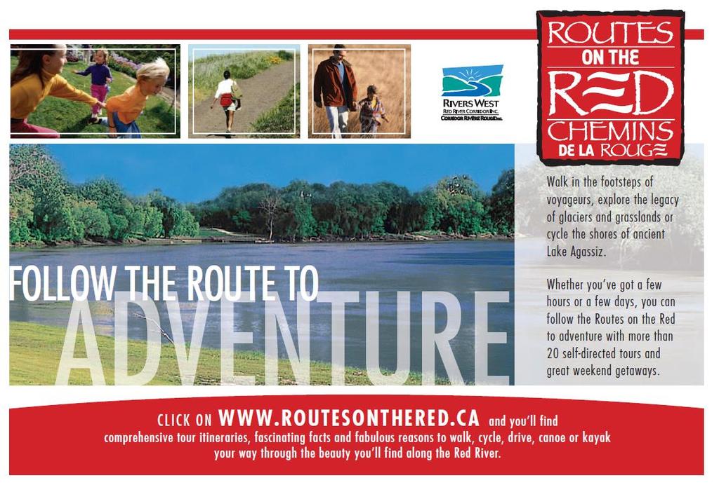
IN THE FOOTSTEPS OF THE VOYAGEURS Self-Directed Walking Tour
 IN THE FOOTSTEPS OF THE VOYAGEURS Self-Directed Walking Tour Welcome to a Routes on the Red self-directed tour of the Red River Valley. These itineraries guide you through the history and the geography
Lake Wissota Access Locations within the LaFayette Township. By Chad Martin
 Lake Wissota Access Locations within the LaFayette Township By Chad Martin Anson/ Wissota Access Point # 1 Road: 195 th St. Associated Fire Numbers: 13294 Defining Characteristics: Forested from road
Portage Spillway Provincial Park. Draft Management Plan
 Portage Spillway Provincial Park Draft Management Plan 2 Portage Spillway Provincial Park Table of Contents 1. Introduction... 3 2. Park History... 3 3. Park Attributes... 4 3.1 Natural... 4 3.2 Recreational...
Driving Time: 3 hours (allow extra time for stops)
") Scenic Byways loop This journey takes visitors through the eastern edge of Mt. Rainier National Park and along two of Washington s most beloved scenic byways, the Chinook Byway and the White Pass Scenic
Scenic Byways loop This journey takes visitors through the eastern edge of Mt. Rainier National Park and along two of Washington s most beloved scenic byways, the Chinook Byway and the White Pass Scenic
WEEKLY HIGHWAY ALERT RICHMOND DISTRICT
 CONTACT: VDOT Customer Service 1-800-367-7623 November 18, Richmondinfo@VDOT.virginia.gov WEEKLY HIGHWAY ALERT RICHMOND DISTRICT COLONIAL HEIGHTS Below is a forecast of road construction that is expected
STITCH TRANSFORMATIVE IDEA 3. SHORELINE STITCH. Re-connect the city to the waterfront and link the east and west Core Circle landscapes
 SHORE STITCH TRANSFORMATIVE IDEA 3. SHORELINE STITCH Re-connect the city to the waterfront and link the east and west Core Circle landscapes 126 LINE PUBLIC WORK 127 TRANSFORMATIVE IDEA 3. SHORELINE STITCH
Iberville International Maritime Terminal and Alexandra Pier
 PLANNING & COMPETITION Location: Montreal, Canada Iberville International Maritime Terminal and Alexandra Pier Design Date: 2013 Master Planning: Provencher_Roy Last April 25, the Montreal Port Authority
Directions to Soil Judging Practice Pits. Lost call Jim Turenne cell , pit location are posted at:
 Directions to Soil Judging Practice Pits. Lost call Jim Turenne cell 401-255-6206, pit location are posted at: http://maps.google.com/maps/ms?hl=en&ie=utf8&msa=0&ll=41.508577,- 71.523743&spn=0.447349,0.829468&z=10&msid=113798583893585652288.0
Public Review on Proposed Changes to Trapping Policy
 Public Review on Proposed Changes to Trapping Policy in Manitoba s Provincial Parks and Other Crown Lands With Recreational Developments In December 2012, two dogs were killed in traps while they were
RIDGEFIELD PARKS February 2016
 RIDGEFIELD PARKS February 2016 Hayden Park Neighborhood Park Amenities Sign with Name of Park and City of Ridgefield Logo Lamp Post Parking Area Play Set Swings Sign with Playground Rules Durable Benches
To Wellness. To Wellness PASSPORT PASSPORT. Partners. Partners. Ashland County Health & Human Services 630 Sanborn Avenue, Ashland, WI
 Partners Ashland County Health & Human Services 630 Sanborn Avenue, Ashland, WI Ashland Bretting Center 320 4th Avenue W., Ashland, WI PASSPORT Bayfield County Health Department 117 E. 6th Street, Washburn,
Tsize group. The Lodge at Fontana has 91 inn rooms.
 The Lodge at Fontana Cabins in the Forest Riverside Camping Accomodations here are a variety of accommodations available throughout the 400 acre valley to fit any budget or Tsize group. The Lodge at Fontana
2 7 5 L O O P 2 5 : : E
 275 loop 25 :: Eden Park 125 Eden Park 25 In Brief Eden Park offers an array of activities, including a playhouse, amphitheater, conservatory, art museum, outdoor sculptures, and gardens. Plan to spend
READ THIS If YOU WANT TO TAKE GREAT PHOTOGRAPHS OF SYDNEY S CLASSIC SKYLINE.
 READ THIS If YOU WANT TO TAKE GREAT PHOTOGRAPHS OF SYDNEY S CLASSIC SKYLINE. URBAN WALKABOUTS Issue #1 2018 SYDNEY, AUSTRALIA URBAN WALKABOUTS SYDNEY SKYLINE FIELD GUIDE Standing on Circular Quay in Sydney,
M. Spina, Councillor J. Cowden, School District No. 73 N. DeCicco, Projects and Planning Supervisor, City of Kamloops
 MINUTES OF A MEETING OF THE KAMLOOPS PARKS AND RECREATION COMMITTEE HELD ON WEDNESDAY, NOVEMBER 26, 2014, AT 7:00 AM IN THE TOURNAMENT CAPITAL CENTRE, MEETING ROOM "D" RECOMMENDATION: That Council authorize
Alexandra pier: New terminal in an old port
 TOPOS Alexandra pier: New terminal in an old port 30.08.201630.08.2016 < GO TO BLOG OVERVIEW Last April the Montreal Port Authority (MPA) officially unveiled its plans for the restoration of Alexandra
AOTA ArtTrek Locations
 AOTA ArtTrek Locations ArtTrek is a summer-long Grand County, CO art adventure. Highlighted by snow-covered mountain vistas and rolling meadows threaded with sparkling streams and rivers, numerous sites
MANITOBA FLOODWAY AND EAST SIDE ROAD AUTHORITY
 MANITOBA FLOODWAY AND EAST SIDE ROAD AUTHORITY 2012 ANNUAL REPORT FOR THE YEAR ENDED MARCH 31, 2012 TABLE OF CONTENTS TABLE OF CONTENTS... 1 CEO S MESSAGE... 3 LEGISLATION... 4 GOVERNANCE... 4 THE MANITOBA
TRAFFIC ALERT FOR DECEMBER 10-14, 2018 Highway Work Zones in the Staunton District
 RELEASE: IMMEDIATE December 7, 2018 CONTACT: Sandy Myers 540-332-9201 (office) STA18 187 540-292-2500 (cell) Sandy.Myers@VDOT.virginia.gov Ken Slack 540-332-9264 (office) 540-414-5670 (cell) Ken.Slack@VDOT.virginia.gov
Bowring Park Self-Guided Walking Tour
 Page 1 of 11 Bowring Park Self-Guided Walking Tour This walk starts at the Bob Whelan Field and continues into the old section of the park towards the east entrance by the duck pond. Walking instructions
Hiawatha National Forest St. Ignace Ranger District. File Code: 1950 Date: August 5, 2011
 United States Department of Agriculture Forest Service Hiawatha National Forest St. Ignace Ranger District W1900 West US-2 St. Ignace, MI 49781 906-643-7900 File Code: 1950 Date: August 5, 2011 Dear National
NEWBORO AND PORTLAND HARBOUR REDVELOPMENT PLANS
 INTRODUCTION The Municipal docks in both Newboro and Portland were transferred to the Township of Rideau Lakes by Parks Canada in 2002. Little has been done to improve the docks physical condition or role
Highway Speed Regulation, amendment
 THE HIGHWAY TRAFFIC ACT (C.C.S.M. c. H60) Highway Speed Regulation, amendment Regulation 55/2000 Registered May 9, 2000 Manitoba Regulation 204/92 amended 1 The Highway Speed Regulation, Manitoba Regulation
Rating: 5.0 (scale of 1-10)
") 95 Community Trail System Groundcover: 2-metre paved path, 1- metre grass buffer on either side. Location: Fort St. John Ownership: City of Fort St. John Rating: 5.0 (scale of 1-10) Strategic value: Linear
95 Community Trail System Groundcover: 2-metre paved path, 1- metre grass buffer on either side. Location: Fort St. John Ownership: City of Fort St. John Rating: 5.0 (scale of 1-10) Strategic value: Linear
Ocean Way at U.S. #1 (Town of Jupiter) Installation of a new traffic signal.
 Installation of a new traffic signal.") PALM BEACH COUNTY TRAFFIC DIVISION UPDATE OF ROAD AND BRIDGE CONSTRUCTION LIST DATE OF ISSUE: FEBRUARY 13, 2013 STATUS FOR FEBRUARY 18, 2013 THROUGH FEBRUARY 24, 2013 *** CONSTRUCTION WORK ZONES ADDED
PALM BEACH COUNTY TRAFFIC DIVISION UPDATE OF ROAD AND BRIDGE CONSTRUCTION LIST DATE OF ISSUE: FEBRUARY 13, 2013 STATUS FOR FEBRUARY 18, 2013 THROUGH FEBRUARY 24, 2013 *** CONSTRUCTION WORK ZONES ADDED
Getting to The Family Centre
 Getting to The Family Centre 65 Hanson Avenue, Kitchener, Ontario, N2C 2H6 Click the links below to jump to the transportation option you want to use! We ll see you soon! Cycling Directions by Bus From
WATER PETALUMA TRAIL WATER WAYS PROJECT PORTFOLIO. petalumawaterways.org OVERVIEW
 WATER TRAIL PROJECT PORTFOLIO OVERVIEW Thirteen miles upstream of San Pablo Bay, Petaluma is the northern point on the San Francisco Bay Water Trail, a network of access points throughout the region. Most
Where can I find the caches?
 SGA GeoTour Rules 2 Where can I find the caches? To find Spring Grove Area GeoTour Caches: 1) Visit www.geocaching.com/adventures/geotours/spring-grove-area 2) Scroll to the bottom of the screen for a
Welcome to the Cross County Trail Public Input Session!
 Welcome to the Cross County Trail Public Input Session! Please sign in on the table below! What are we doing here? Camden County has proposed a bicycle and pedestrian trail spanning across the entire county.
Rail Trail Walking Challenge!
 Included with these routes is the Municipality of the District of Lunenburg s trail brochure. This map gives a rough estimate of the locations of our 6 rail trails, all managed by volunteer associations!
Mt Kuring-gai Track to Berowra station
 Mt Kuring-gai Track to Berowra station 4 hrs 15 mins 9.7 km One way Hard track 4 553m This walk explores three valleys, with great displays of wild flowers in spring, and some nice sandstone overhangs.
Greater Grand Forks I 29
 Example Itinerary: 9:30am- [1] Arrive at Butterfly Garden & Grasslands EXIT onto Demers Ave. heading East. Take a RIGHT on County Road 2. Take a RIGHT on Highway 72 S. Garden is 3 miles on RIGHT side of
RAINBOW TRAIL epoint.edu.vn RAINBOW TRAIL. page 1 / 5
 page 1 / 5 page 2 / 5 rainbow trail pdf Interactive Map of Greater Sudbury Trails. We are working towards a future digital trail map upgrade. To use the current map, click on a desired Rainbow Routes'
TRAFFIC ALERT FOR JANUARY 15-19, 2018 Highway Work Zones in the Staunton District
 RELEASE: IMMEDIATE January 11, 2018 CONTACT: Sandy Myers 540-332-9201 (office) STA18-007 540-292-2500 (cell) Sandy.Myers@VDOT.virginia.gov Ken Slack 540-332-9264 (office) 540-414-5670 (cell) Ken.Slack@VDOT.virginia.gov
191 LOMBARD AVENUE (387 MAIN STREET) UNION TOWER BUILDING HISTORICAL BUILDINGS COMMITTEE
 UNION TOWER BUILDING HISTORICAL BUILDINGS COMMITTEE") 191 LOMBARD AVENUE (387 MAIN STREET) UNION TOWER BUILDING HISTORICAL BUILDINGS COMMITTEE 9 July 1983 191 LOMBARD AVENUE (387 MAIN STREET) UNION TOWER BUILDING A bronze plaque on the side of the Union Tower
191 LOMBARD AVENUE (387 MAIN STREET) UNION TOWER BUILDING HISTORICAL BUILDINGS COMMITTEE 9 July 1983 191 LOMBARD AVENUE (387 MAIN STREET) UNION TOWER BUILDING A bronze plaque on the side of the Union Tower
CORNWALL WATERFRONT PLAN 2007
 CANAL LANDS CANAL LANDS Page 58 Introduction This chapter details areas of possible development or redevelopment, and lands to be protected from any form of development in the Canal Lands area. As outlined
Race Booklet
 Race Booklet www.gorgeousseries.com GORGEOUS RUNNER REWARDS! 5% off a 2 nd relay in 2018 10% off a 3 rd 20% off a 4 th and 30% off your 5 th relay in 2018! Saturday, May 19 Gorgeous Portland Pub Relay
Manitoba Unforgettable Arctic Experiences
 Great Drives to Great Places Manitoba Unforgettable Arctic Experiences With stunning landscapes, dancing Northern Lights, rural fairs and festivals, warm hospitality and majestic wildlife, any trip to
2.1 HISTORIC CONTEXT. View looking South from Main & 6th circa Typical logging scene with bullocks and skid road, 1885
 2.1 HISTORIC CONTEXT View looking North from Main & 7th circa 1889 View looking South from Main & 6th circa 1893 Typical logging scene with bullocks and skid road, 1885 The history of the Mt. Pleasant
Androscoggin River Trail Access Sites. North Woods. 168 miles from its source at Lake Umbagog to Merrymeeting Bay
 Androscoggin River Trail Access Sites North Woods 168 miles from its source at Lake Umbagog to Merrymeeting Bay Trail Under Construction More than 40 Public Access Sites Available Androscoggin River Watershed
The Narrows Waterfront Park A Crown Jewel for Southern Brooklyn
 The Narrows Waterfront Park A Crown Jewel for Southern Brooklyn In New York, the unquestioned popularity of urban spaces such as Riverside Park, the High Line, Brooklyn Bridge Park and others has demonstrated
Falls Lake Nature Trail
 Falls Lake Nature Trail By Walker Blanchard May 05, 2008 Introduction I have lived in this area for over 22 years. I have hiked / biked (back when you used to be allowed) the falls lake nature trail, too
Kingston Islands. Your Ticket to Kingston. and the ktic.ca kingstontrolley.ca kpass.ca. Kingston Ontario Canada
 Kingston and the Trip Planner 1000 Islands Kingston Ontario Canada 21 National Historic Sites Canada s First Capital UNESCO World Heritage Sightseeing Cruises Dining Cruises Trolley Tours Your Ticket to
Wild Pacific Trail Society
 Wild Pacific Trail Society Section H Completion Report January 24, 2014 Project Manager: Tel: Email: Jim Martin 250-726-7565 oysterjim@hotmail.com Project Report: Tel: Email: Heather Grimshire 250-266-2053
TRAFFIC ALERT FOR MARCH 26-30, 2018 Highway Work Zones in the Staunton District
 RELEASE: IMMEDIATE March 23, 2018 CONTACT: Sandy Myers 540-332-9201 (office) STA18 057 540-292-2500 (cell) Sandy.Myers@VDOT.virginia.gov Ken Slack 540-332-9264 (office) 540-414-5670 (cell) Ken.Slack@VDOT.virginia.gov
Norris Lake Provincial Park. Draft Management Plan
 Norris Lake Provincial Park Draft Management Plan 2 Norris Lake Provincial Park Table of Contents 1. Introduction... 3 2. Park History... 3 3. Park Attributes... 4 3.1 Natural... 4 3.2 Recreational...
RW Bruhn Bridge and Approaches Project
 RW Bruhn Bridge and Approaches Project The Trans-Canada Highway 1 RW Bruhn Bridge and Approaches Project involves four-laning approximately 1.9 km of Highway 1 in Sicamous, including replacement of the
Hickman s (Diamond) Mills
 Mills") Hickman s (Diamond) Mills On the east branch of Naaman's Creek, near the northwest boundary of Lower (and Upper) Chichester townships, was the saw- and grist-mill of Samuel Hickman, which was one of the
Hickman s (Diamond) Mills On the east branch of Naaman's Creek, near the northwest boundary of Lower (and Upper) Chichester townships, was the saw- and grist-mill of Samuel Hickman, which was one of the
SOUTHBOUND YONGE STREET TO EASTBOUND HIGHWAY 401 F L Y -UNDER
 SOUTHBOUND YONGE STREET TO EASTBOUND HIGHWAY 401 F L Y -UNDER Proposal to Eliminate Traffic Gridlock in South North York Centre Area With Southbound Yonge Street to Eastbound Highway 401 Fly-UNDER A much
KING STREET TRANSIT PILOT
 KING STREET TRANSIT PILOT Update toronto.ca/kingstreetpilot #kingstreetpilot HIGHLIGHTS TRANSIT RIDERSHIP TRANSIT CAPACITY To respond to this growth in ridership, the TTC has increased the capacity of
NFTA Access Enhancement Study for Canalside and Cobblestone Alternatives Discussion. Alternative A South Park Avenue
 Alternative A South Park Avenue Alternative A Summary Alternative A extends Metro Rail service around the foot of Main Street east along South Park Avenue to serve a new station platform located along
GETTING TO KNOW GLADYS, THE BUS AT CLAYTON S DAIRYAIRE STRIP Fireweed Airstrip (0AK8) West McCarthy, Alaska
 West McCarthy, Alaska") GETTING TO KNOW GLADYS, THE BUS AT CLAYTON S DAIRYAIRE STRIP Fireweed Airstrip (0AK8) West McCarthy, Alaska July 13-15, 2018 Al and Beth Clayton 500 L Street, Ste. 200 Anchorage, AK 99501 Al.clayton@cdlaw.pro
GETTING TO KNOW GLADYS, THE BUS AT CLAYTON S DAIRYAIRE STRIP Fireweed Airstrip (0AK8) West McCarthy, Alaska July 13-15, 2018 Al and Beth Clayton 500 L Street, Ste. 200 Anchorage, AK 99501 Al.clayton@cdlaw.pro
 BROWARD DEANERY 1 ALL SAINTS (954) 467-6496 333 Tarpon Dr. Ft. Lauderdale, FL 33301 4 INTERCESSION (954) 763-5986 501 N.W. 17 St. Ft. Lauderdale, FL 33311 I-95 to Broward Blvd. exit. Go east on Broward
PLACES TO WALK IN PORT COQUITLAM
 Places to Walk in Port Coquitlam Port Coquitlam is a walker s paradise, whether you re looking for a leisurely stroll or a challenging trek. Lace up your sneakers and try out these 18 walks submitted by
Corridor Management Plan for Virginia Coal Heritage Trail WMTH Corporation, 2011, trailsrus.com
 CHAPTER IV: HIGHLIGHTS Along the The St. Paul loop travels over 80 miles through the counties of Russell, Scott, Lee and Wise before ending back at St. Paul. As noted earlier, St. Paul holds the distinction
3529 Souris River Flood Plan (Phase MI-1)
") Date: September 28, 2018 To: Derek Hackett, Public Information Officer From: Grant Goldader, Civil Engineering Specialist Re: Traffic Control Report for the week of 10/01/2018 3529 Souris River Flood Plan
Date: September 28, 2018 To: Derek Hackett, Public Information Officer From: Grant Goldader, Civil Engineering Specialist Re: Traffic Control Report for the week of 10/01/2018 3529 Souris River Flood Plan
Henry s Fork Angler Access. Above Mesa Falls
 Henry s Fork Angler Access Above Mesa Falls Table of Contents 1. Frome Park 2. Henry s Lake Fish Hatchery 3. Henry s Lake State Park 4. Highway 20 Bridge 5. Flat Ranch 6. Big Springs 7. Big Springs Water
I CE Interpretation. Floods Pathways, Loops, Spurs, and Gateway Communities
 AGE F LOODS I CE Floods Pathways, Loops, Spurs, and Gateway Communities 88 Ice Age Floods Study of Alternatives F l o o d s Well-Traveled Meteorite The Willamette meteorite is the largest ever found in
200, 200B. Route descriptions. Useful information
 Route:, B Effective 4 March 17 This timetable covers bus services linking: Eliza Place Hyde City Destination:, & to city Also shows C W N S E Useful information Website adelaidemetro.com.au on-line journey
Chapter 2: Entire US287 Corridor
 Chapter 2: Entire US287 Corridor The US287 Study Area spans four incorporated jurisdictions and two counties. Due to the length and density of infrastructure along the US287 Study Area, corridor-wide maps
HIKING/BIKING IN MERRITT AREA
 HIKING/BIKING IN MERRITT AREA Coquihalla Lakes: Just inside the southern boundary of BC Park's Coquihalla Summit Park, a nice little twin lakes paddle with a private campground & lodge is the Coquihalla
Calgary River Access Strategy Priority Sites and Proposed Funding
 Calgary River Access Strategy Priority Sites and Proposed Funding CPS2017-0103 ATTACHMENT 2 A total of $7,660,000 (Class 5 estimate) is required to implement all sites within the Calgary River Access Strategy;
Neighbourhood Committee NDG - Westmount. September 12, 2016
 Neighbourhood Committee NDG - Westmount September 12, 2016 2 Presentation Outline Requests from the committee members Feedback on previous questions Work update and hindrance of the Turcot Project Ministry
IMPROV OF THE NORTH May 2-4, 2008 Ottawa, Canada
 THE HENDRICKS INSTITUTE PRESENTS IMPROV OF THE NORTH May 2-4, 2008 Ottawa, Canada Location Junior Ranks Mess 4 Queen Elizabeth Dr. Ottawa, Ontario Canada K2P 2H9 Schedule Friday, May 2, 9:30 am 6:00 pm
TRAFFIC ALERT FOR DECEMBER 25, 2017 to JANUARY 5, 2018 Highway Work Zones in the Staunton District
 RELEASE: IMMEDIATE December 21, 2017 CONTACT: Sandy Myers 540-332-9201 (office) STA17-204 540-292-2500 (cell) Sandy.Myers@VDOT.virginia.gov Ken Slack 540-332-9264 (office) 540-414-5670 (cell) Ken.Slack@VDOT.virginia.gov
2 Moose Lake & Birch Point. Provincial Parks. 3 Whiteshell Provincial Park. 4 Whitemouth Falls Provincial Park. 5 Pinawa Dam Provincial Park.
 12 68 14 13 Lake Winnipeg 1 Main Route Buffalo Point First Nation 2 Moose Lake & Birch Point Provincial Parks 3 Whiteshell Provincial Park 4 Whitemouth Falls Provincial Park 5 Pinawa Dam Provincial Park
Location Photography 13
 13 Location Photography CONTEMPORARY WINNIPEG 1 2 3 4 14 CONTEMPORARY WINNIPEG 5 6 7 8 9 10 11 15 CONTEMPORARY WINNIPEG 12 13 14 15 16 CONTEMPORARY WINNIPEG 16 17 EXCHANGE DISTRICT, DOWNTOWN 18 17 19 20
WEEKLY HIGHWAY ALERT RICHMOND DISTRICT
 HIGHWAY ALERT VirginiaDOT.org CONTACT: Public Affairs Jan. 5, 2009 Richmondinfo@VirginiaDOT.org WEEKLY HIGHWAY ALERT RICHMOND DISTRICT COLONIAL HEIGHTS Road construction that is expected to cause delays
Design and Construction of the Lake St. Martin Emergency Outlet
 Design and Construction of the Lake St. Martin Emergency Outlet Background 2011 was the largest flood event experienced in the last 200 years Flood Fighting required some difficult decisions by the Manitoba
Chocolate Bar GOLD Mining Claim Oro Grande, California 92368
 Gold Mining Claim 20 Acres Chocolate Bar GOLD Mining Claim Oro Grande, California 92368 Sale Highlights Formerly: Branch Gold Mine Heavy GOLD & Silver Concentrations: Remaining 300' Horizontal Tunnel with
THE ST. ANDREWS TIMES
 R.M. of St. Andrews Box 130 500 Railway Avenue Clandeboye, Manitoba R0C 0P0 Phone: 204-738-2264 1-866-738-2264 (toll free) Fax: 204-738-2500 E-Mail: office@rmofstandrews.com Website: www.rmofstandrews.com
Presentation Overview
 DON NARROWS Historical and Existing Conditions March 29, 2008 Presentation Overview 1. Project Location and Background 2. Historical Context How did the Don Narrows Come to Be? 3. The Today 4. Next Steps
Cascading Rivers Scenic Bikeway
 Milo McIver State Park Main Clackamas Start Estacada Faraday Rd 5 Promontory Park Estacada Start ESTACADA CHAMBER OF COMMERCE (parking in back) SE 4 th Ave Stay west to take Faraday Rd. (closed to motorized
World War II Secret City Gates (As published in The Oak Ridger s Historically Speaking column on April 5, 2006)
") From 1943 to 1949 the city of Oak Ridge (fifth largest city in Tennessee) was not on any maps and existed as a secure gated community. The installation of fences and guard portals at the various roads
From 1943 to 1949 the city of Oak Ridge (fifth largest city in Tennessee) was not on any maps and existed as a secure gated community. The installation of fences and guard portals at the various roads
ATTACHMENT B. Reference No.
 ATTACHMENT B Projects in the Five-Year Capital Improvement Program for Fiscal Years Ending 2014-2018 GOVERNMENT CODE SECTION 65402 GENERAL PLAN CONFORMITY ANALYSIS 1 4 Orcutt GS Station 21 (Orcutt) Rebuild
2 4 3 Registration 5 6 1
 2 4 Registration 3 5 1 6 4 2 Registration 3 5 1 6 1 NC43- Contest Participants South Parking 2 NC48 & 21- Contest Participants North Parking 3 NC60- Grading and Tech Volunteers parking ( Spill Over for
Long water shutdown scheduled for Tuesday, September 18
 Thank you for your interest in the Center City Connector Streetcar. In this weekly update, you ll find information about ongoing construction for the 1st phase of utility work in Pioneer Square. Utility
BEAVER LAKE ACCESS AREA SUMMARY 2017 Edition
 BEAVER LAKE ACCESS AREA SUMMARY 2017 Edition DEVELOPED BY THE BEAVER LAKE PROPERTY and SAFETY COMMITTEE 2 October 2017 1 NOTICE: This document supersedes and nullifies all previous versions of Beaver Lake
South Dakota RV Parks and Campgrounds
 1 South Dakota RV Parks and Campgrounds Three Flags RV Park and Camp Brief Description: Large pull thru RV sites 30' wide by 80' long. Park offers coin laundry, free cable TV with full hookups, free WiFi,
Canada Rocky Mountain Adventure Into the Wild
 Canada Rocky Mountain Adventure Into the Wild Itinerary Canada Rocky Mountain Adventure Into the Wild 15 days / 14 nights Calgary Kananaskis Country Spray Lake Canmore Banff Lake Louise Moraine Lake Jasper
Eakin Community Park. Getting There
 Eakin Community Park Quiet woods along the Accotink Creek are the hallmark of Eakin Community Park. Actually a string of smaller parks, Eakin is made-up of Mantua Park, Kern Drive Park, Eakin Park, Woodburn
ROBERTS CREEK PROVINCIAL PARK MASTER PLAN. November, 1981
 Ministry of Lands, Parks and Housing Parks and Outdoor Recreation Division Park Operations Branch North Vancouver, B. C. ROBERTS CREEK PROVINCIAL PARK MASTER PLAN November, 1981 Mr. G. Trachuk Director
Directions to Gathering/other Events:
 Directions to Gathering/other Events: Scroll down the list below (churches are in alphabetical order)!! Andrews Chapel UMC: From Conway: From Conway: Take 501 to Highway 31 North. Take the Highway 9 exit