Andean uplift and Atacama hyper-aridification: A climate modeling perspective + some new ideas to test
|
|
|
- Ariel Gaines
- 6 years ago
- Views:
Transcription
 Departamento de Geofísica (2) Departamento de Geología Universidad de Chile 120 W 90 W 60 W 30")
1 Andean uplift and Atacama hyper-aridification: A climate modeling perspective + some new ideas to test 0 S 30 S René Garreaud 1, Alejandra Molina 1, Marcelo Farias 2 (1) Departamento de Geofísica (2) Departamento de Geología Universidad de Chile 120 W 90 W 60 W 30 W 60 S
 In long time scales (>10000 years), climate-geomorphology coupled Geomorphology is not fixed an can alter climate Climate changes modifies")
2 My word-cloud based on paper s abstract ( ) and constructed using Wordle Paleoclimate In short time scales (days-centuries), climate-geomorphology uncoupled Geomorphology is a fixed BC for climate Climate doesn t alter landscape (actually, it does) In long time scales (>10000 years), climate-geomorphology coupled Geomorphology is not fixed an can alter climate Climate changes modifies geomorphology
 Precipitation (green shadow)")
3 General circulation in an aqua-planet Perpetual Equinox NE trades ITCZ: Intertropical Convergence Zone SE trades Surface wind (arrows) Precipitation (green shadow)
4 Idealized (zonally symetric) circulation disturbed by continents 0 S Midlat. Precip. Tropical rainfall SCu & Cold SST Continental depression & Low Level Jet S. Atlantic Anticyclone 30 S SE Pacific Anticyclone Midlatitude Storm track 60 S 120 W 90 W 60 W 30 W

5 High Andes & dry Atacama Factor I: Subtropical Location SLP, V sfc 1015 hpa 1020 hpa SST 28 C 23 C 17 C 10 C

6 High Andes & dry Atacama Iquique 6 mm/década Calama 12 mm/decada Condiciones actuales hiper-áridas a lo largo del desierto costero. Sin embargo, abundante evidencia geológica de un pasado remoto (Ma) menos extremo en cuanto a déficit de precipitación
7 High Andes & dry Atacama Factor II: Rain shadow effect Hartley and Houston 2003
8 High Andes & dry Atacama Posicionamiento de Sud América en rango actual de latitudes ( Ma)

9 Andean uplift Atacama hyper-aridification
10 Andean uplift Atacama hyper-aridification

11 Atacama hyper-aridification Andean uplift Lamb and Davis; Nature 2003
12 Atacama hyper-aridification Andean uplift Sea level Plenty of sediment transport Abundant rainfall Nazca Plate Wet slip Sea level Little sediment transport Deficient rainfall Nazca Plate Dry slip Adapted from Lamb and Davis; Nature 2003

13 Southeast Pacific Cooling Atacama hyper-aridification Perpetual ENSO Strong Humboldt Philander et al. 2004
14 Conceptually, both Andean uplift (enhanced bloking of moist air) and SEP cooling (less evaporation from ocean) may increase dryness of the Atacama desert it would be nice to use a simple climate model to study these two conditions. We use PLASIM, an Earth System Model of Intermediate Complexity from Hamburg University: Atmospheric component: PUMA Simple slab model for SST and Sea Ice SIMBA for biosphere Coarse resolution: 3ºx3º lat-lon We performed 50 year long simulations altering one Boundary condition at a time
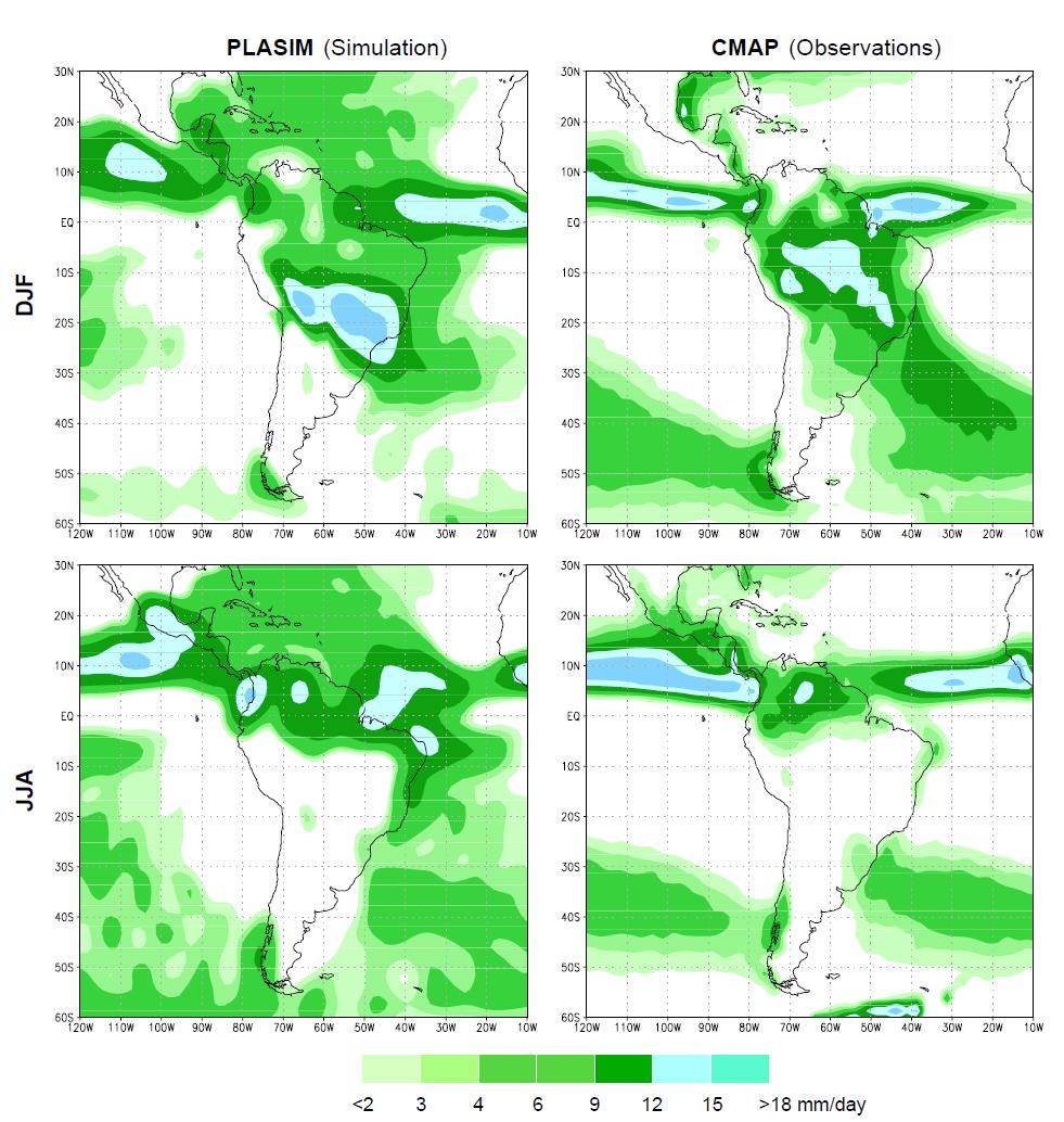
15 Model Validation
16 Model Validation Long-term meandjf 900 hpa wind 0.3*Topo (red) and Control (blue) LLJ

 900 hpa winds and")
17 PLASIM Topography Experiments 0.3*Topo minus Control (DJF) 900 hpa winds and Precip % Precip ( P/Pc)

18 REGCM Topography Experiments CTL Low Andes Insel et al. 2009, Climate Dynamics Ehlers and Poulsen 2009, EPSL
 and Control (blue) Lower Andes Less lee-side subsidence Weaker continental low Weaker LLJ")
19 PLASIM Topography Experiments Long-term meandjf 900 hpa wind 0.3*Topo (red) and Control (blue) Lower Andes Less lee-side subsidence Weaker continental low Weaker LLJ Reduced moist transport toward subtropics LLJ
 only wsep: warmer Southeast")
20 PLASIM Humboldt Experiments usst: SST(ϕ) only wsep: warmer Southeast Pacific


21 PLASIM Humboldt Experiments wsep minus Control (DJF) 900 hpa winds and Precip % Precip ( P/Pc)
: Precip Evap = Convergence + Advection + Transient Differences between wsep minus CTL for a")

22 PLASIM Humboldt Experiments Large scale field allows diagnostic of Precipitation (Lenters and Cook 1995): Precip Evap = Convergence + Advection + Transient Differences between wsep minus CTL for a grid box over the SEP: +2.5 mm +1.4 mm +0.7 mm +0.2 mm In human terms, shallow, non-precipitating stratus embedded in a cool MBL are replaced by moderate-precipitating, trade wind cumulus in warmer MBL. SST


23 Barreiro et al. 2005, Climate Dynamics GFDL GCM Humboldt Experiments
24 Summary 0 S The Andes does organize precipitation over South America and is responsible for the existence of a low level jet that feeds convection at subtropical latitudes east of the Andes Climate model experiments show that removal of the Andes doesn t increase rainfall over the Atacama desert, but rather dries up interior of the continent 30 S Hyper-aridity there is much likely produced by the cold SST along the coast, and hence related with the intensification of the Humboldt current 60 S 120 W 90 W 60 W 30 W
 Western cordillera Pampa del Tamarugal (absolute desert, 1000-1500 m ASL) Coastal scarp ( 1000 m ASL) Pacific ocean Picture")
25 Some new questions: how does remote-past changes in northern Chile relief (specially coastal scarp) affected the Altiplano climate? Altiplano ( 4000 m ASL) Western cordillera Pampa del Tamarugal (absolute desert, m ASL) Coastal scarp ( 1000 m ASL) Pacific ocean Picture courtesy of Aurelie Coudurier

26 Lower troposphere over the SE Pacific Cloud topped marine boundary layer (MBL) capped by a strong temperature inversion driven by subsidence Simulated MBL Height x 2 Oct-Nov mean

27 MBL height 1000 m ASL nearly constant along the coast. This value results from a balance between large-scale subsidence and turbulence driven turbulence atop MBL Low T, high q


28 High Andes & dry Atacama Factor III: Diurnal circulations


29 South America monsoonal regime and Altiplano rainfall Mean annual cycle Colors: OLR (proxy of precipitation) Streamlines: 200 hpa (~12 km) wind Bolivian High


30 South America monsoonal regime and Altiplano rainfall VIS and IR2 GOES images during an active summer afternoon

31 Geographical distribution and diurnal cycle of the convective clouds over the central Andes

32 Ciclo anual y distribución espacial de PP

33 Summer Altiplano rainfall variability An {Easterly flow (continental advection) wet conditions} relationship is seen at synoptic, seasonal and interannual scales Falvey and Garreaud 2005
34 Inversion 1 km ASL Current climate Summer afternoon Large-scale easterly flow Dry, warm air from the free troposhere Dry zone Moist, warm air Moist, cool MBL Inversion 1 km ASL ca 10 Ma Summer afternoon Large-scale easterly flow Moist, warm air Moist, cool MBL
35 Reduction of the coastal cordillera height likely produces more humid conditions in the western cordillera (westward expansion of the Altiplano winter regime) but how much? Numerical simulations with high horizontal resolution Wait about a year to find out. Merci!
The Andes Chap. 1 - Geographical context Chap. 2 - Large scale climate
 The Andes Chap. 1 - Geographical context Chap. 2 - Large scale climate René D. Garreaud Geophysics Department Universidad de Chile Center for Climate and Resilience Research, CR2 We all love the Andes..
Friday, November 10, 2017
 Friday, November 10, 2017 Andes and Midlatitude Countries Objective: Summarize the main physical features and regions of the Southern Cone. Identify and locate the urban centers and understand the pattern
A funny sounding lake. South American Landforms, Climate, and Vegetation
 A funny sounding lake South American Landforms, Climate, and Vegetation 3 4 Essential Question: How have physical features and climate affected the population distribution of Latin America? 5 I. Landforms
Latin America. Physical Geography
 + Latin America Physical Geography + I. Landforms A. Caribbean & Central America 1. Mexico is dominated by two mountain chains, collectively called the Sierra Madre. A high plateau is situated in between.
Summertime Precipitation Variability and Atmospheric Circulation over the South American Altiplano: Effects of Lake Titicaca and Salar de Uyuni
 Summertime Precipitation Variability and Atmospheric Circulation over the South American Altiplano: Effects of Lake Titicaca and Salar de Uyuni Maura Hahnenberger Oklahoma Weather Center Research Experiences
Actual Climatic Conditions in ERB. Online Resource 1 corresponding to:
 Actual Climatic Conditions in ERB. Online Resource 1 corresponding to: Article Title: Climatic Trends and Impact of Climate Change on Agriculture in an Arid Andean Valley. Journal Name: CLIMATIC CHANGE
The Lesser Antilles. Dominican Republic), and Puerto Rico
, and Puerto Rico") The Caribbean Islands are archipelagoes or groups of islands. The major archipelagoes are: The Greater Antilles - Cuba, Jamaica, Hispaniola (Composed of Haiti and the Dominican Republic), and Puerto Rico
The Caribbean Islands are archipelagoes or groups of islands. The major archipelagoes are: The Greater Antilles - Cuba, Jamaica, Hispaniola (Composed of Haiti and the Dominican Republic), and Puerto Rico
LAST TIME (Happy 300 th Birthday Ben Franklin!)
") LAST TIME (Happy 300 th Birthday Ben Franklin!) Latin American Diversity: Introduction Physical Geography of Mexico, Caribbean, and Central America: 1. Mexican drylands 2. Mesoamerican Highlands 3. Coastal
LAST TIME (Happy 300 th Birthday Ben Franklin!) Latin American Diversity: Introduction Physical Geography of Mexico, Caribbean, and Central America: 1. Mexican drylands 2. Mesoamerican Highlands 3. Coastal
Integrated remote and in situ analysis of a playa lake groundwater system in northern Chile. Katherine H. Markovich The University of Texas at Austin
 Integrated remote and in situ analysis of a playa lake groundwater system in northern Chile Katherine H. Markovich The University of Texas at Austin Hydrogeology of Arid Environments March 15 th, 2012
Chapter 20. The Physical Geography of Africa South of the Sahara
 Chapter 20 The Physical Geography of Africa South of the Sahara Chapter Objectives Identify the major landforms, water systems, and natural resources of Africa south of the Sahara. Describe the relationship
Latin America. Physical Geography
 Latin America Physical Geography Regions Latin America can be divided into separate regions based on physical geography or cultural geography. Regions If we look at physical geography Latin America has
The Geography of Climate
 The Geography of Climate Objective for Today: Today we will examine ways that latitude and landforms influence climate The focus of our study will be the South American Continent in the Formal Region known
South American Countries. Capital Location Population Terrain Climate
 South American Countries Capital Location Population Terrain Climate Andes Mountains Four large areas that make up the Central Plains: Llanos, the Selva, the Gran Chaco, and the Pampas Brazilian Highlands
Latin America. Introduction
 Latin America Introduction What are the 5 Themes of Geography? Draw lines to connect the theme to the definition: Location How humans and the environment impact each other Physical and human characteristics
Ten Day Climate Watch Bulletin N 27 Dekad 21 st to 30 th September, 2014
 African Centre of Meteorological Application for Development Centre Africain pour les Applications de la Météorologie au Développement Ten Day Climate Watch Bulletin N 27 Dekad 21 st to 30 th September,
ENSO Influence on Coastal Fog-Water Yield in the Atacama Desert, Chile
 Aerosol and Air Quality Research, 18: 127 144, 2018 Copyright Taiwan Association for Aerosol Research ISSN: 1680-8584 print / 2071-1409 online doi: 10.4209/aaqr.2017.01.0022 ENSO Influence on Coastal Fog-Water
ICPAC. IGAD Climate Prediction and Applications Centre Monthly Bulletin, February 2017
 IGAD CLIMATE PREDICTION AND APPLICATIONS CENTRE ICPAC Bulletin Issue March 2017 Issue Number: ICPAC/02/299 IGAD Climate Prediction and Applications Centre Monthly Bulletin, February 2017 For referencing
STUDY GUIDE. The Land. Physical Features of Latin America. Chapter 8, Section 1. Terms to Know DRAWING FROM EXPERIENCE ORGANIZING YOUR THOUGHTS
 For use with textbook pages 193 198. The Land Terms to Know cordillera A mountain range that runs parallel to another mountain range (page 194) altiplano A high plain (page 194) escarpment A steep cliff
Objective. Students will familiarize themselves with the physical features and climates of Latin America.
 Journal Write KWL What do you KNOW about Latin America? What do you WANT TO KNOW about Latin America? What did you LEARN today that you didn t know before? Latin America Objective Students will familiarize
African Centre of Meteorological Applications for Development Centre Africain pour les Applications de la Météorologie au Développement
 African Centre of Meteorological Applications for Development Centre Africain pour les Applications de la Météorologie au Développement Ten Day Climate Watch Bulletin N 26 Dekad 11 th to 20 th September,
Modification of the Stratification and Velocity Profile within the Straits and Seas of the Indonesian Archipelago
 DISTRIBUTION STATEMENT A. Approved for public release; distribution is unlimited. Modification of the Stratification and Velocity Profile within the Straits and Seas of the Indonesian Archipelago Arnold
World Geography Ch. 7.2 Climate Regions of Latin America
 World Geography Ch. 7.2 Climate Regions of Latin America BR: D10 When you think of Latin America, what types of climates do you think are down there? Write down which of the following you believe are there:
African Centre of Meteorological Applications for Development Centre Africain pour les Applications de la Météorologie au Développement
 African Centre of Meteorological Applications for Development Centre Africain pour les Applications de la Météorologie au Développement Ten Day Climate Watch Bulletin N 15 Dekad 21 st to 31 st May, 2015
Lecture #1: Introduction
 Anthropology G4210 The Rise of Andean Civilization T. D'Altroy September 8, 1999 Lecture #1: Introduction 1. purposes of the course a. examination of the nature and development of societies in the Andes
Chapter Objectives. Describe the dominant landforms and natural resources of Southeast Asia. Discuss Southeast Asia s climate and vegetation.
 Chapter Objectives Describe the dominant landforms and natural resources of Southeast Asia. Discuss Southeast Asia s climate and vegetation. The Land Section 1 Objectives Describe how tectonic plates and
ANDEX: A Regional Hydrology Program for the Andes
 ANDEX: A Regional Hydrology Program for the Andes Silvina Solman CIMA (CONICET-UBA) - Universidad de Buenos Aires Argentina Germán Poveda Universidad Nacional de Colombia, Medellín Colombia TPE-GHP/GEWEX
Moisture variability over the South American Altiplano during the South American Low Level Jet Experiment (SALLJEX) observing season
 observing season") JOURNAL OF GEOPHYSICAL RESEARCH, VOL. 110,, doi:10.1029/2005jd006152, 2005 Moisture variability over the South American Altiplano during the South American Low Level Jet Experiment (SALLJEX) observing
JOURNAL OF GEOPHYSICAL RESEARCH, VOL. 110,, doi:10.1029/2005jd006152, 2005 Moisture variability over the South American Altiplano during the South American Low Level Jet Experiment (SALLJEX) observing
Latin America. Chapter 9 Physical Geography
 Latin America Chapter 9 Physical Geography Latin American Regions Middle America includes Mexico and the Central American countries The Caribbean Islands South America Mexico Landforms Sierra Madre Oriental
TRENDS IN MAXIMUM AND MINIMUM TEMPERATURE IN THE CENTRAL ANDES OF PERU (MANTARO RIVER BASIN)
") TRENDS IN MAXIMUM AND MINIMUM TEMPERATURE IN THE CENTRAL ANDES OF PERU (MANTARO RIVER BASIN) Grace Trasmonte *, Yamina Silva, Raúl Chavez and Berlin Segura Instituto Geofísico del Perú ABSTRACT * 1 1.
TRENDS IN MAXIMUM AND MINIMUM TEMPERATURE IN THE CENTRAL ANDES OF PERU (MANTARO RIVER BASIN) Grace Trasmonte *, Yamina Silva, Raúl Chavez and Berlin Segura Instituto Geofísico del Perú ABSTRACT * 1 1.
Geographic Qualities of South America
 Geographic Qualities of South America 1. South America is the fourth largest continent in area. It is located in the Western Hemisphere, lying southwest of North America. Most of South America lies in
CLIMATE DIAGNOSTIC BULLETIN FOR AFRICA
 CLIMATE DIAGNOSTIC BULLETIN FOR AFRICA N 02 FEBRUARY, 2019 OCEAN-ATMOSPHERE MONITORING & PREDICTION 1 SUMMARY FEBRUARY 2019 The precipitation for the month of February, 2019 was above to well above average
African Centre of Meteorological Applications for Development Centre Africain pour les Applications de la Météorologie au Développement
 African Centre of Meteorological Applications for Development Centre Africain pour les Applications de la Météorologie au Développement Ten Days Climate Diagnostics Bulletin N 03 Dekad 3, 21 st to 31 st
How stable or variable is the climate of Amazonia?
 How stable or variable is the climate of Amazonia? Frank Mayle Mitch Power Bronwen Whitney University of Edinburgh Mark Bush Florida Institute of Technology Paul Baker, Sheri Fritz etc etc etc Glacial-interglacial
Optical Seeing and Infrared Atmospheric Transparency in the Upper Atacama Desert
 **Astronomical Site Evaluation in the Visible and Radio Range** ASP Conference Series, Vol. **VOLUME**, **2001** **Jean Vernin et al.** Optical Seeing and Infrared Atmospheric Transparency in the Upper
Regional Atlas: Introduction to Latin America
 Chapter 9, Section World Geography Chapter 9 Regional Atlas: Introduction to Latin America Copyright 2003 by Pearson Education, Inc., publishing as Prentice Hall, Upper Saddle River, NJ. All rights reserved.
2.1 What is the climate like?
 José Medeiros This fact sheet allows you to see how varied the countryside is across Brazil. 2.1 What is the climate like? Most of Brazil is in the Southern Hemisphere, where the seasons are the opposite
African Centre of Meteorological Applications for Development Centre Africain pour les Applications de la Météorologie au Développement
 African Centre of Meteorological Applications for Development Centre Africain pour les Applications de la Météorologie au Développement Ten Day Climate Watch Bulletin N 34 Dekad 1 st to 10 th December,
Atacama, floods and the inevitable Harvey
 { Atacama, floods and the inevitable Harvey A climate-related disaster a day for earth WHEN THE breathtaking news arrived, everybody mourned. Desierto florido, or flowering desert, returned to the Atacama
The Geological Pacific Northwest. Wednesday February 6, 2012 Pacific Northwest History Mr. Rice
 The Geological Pacific Northwest Wednesday February 6, 2012 Pacific Northwest History Mr. Rice 1 Free Response #2 Please do not simply list the items for this response. Full sentences!!! Minimum of 3-5
GEOGRAPHY AND HISTORY
 GEOGRAPHY AND HISTORY YEAR 1, PART 1 www.vicensvives.es Contents 01 Our planet Earth 02 The representation of the Earth: maps 03 The Earth s relief 04 Rivers and seas 05 Weather and climate 06 Climates
THE TWENTY FIRST ANNUAL SOUTHERN AFRICA REGIONAL CLIMATE OUTLOOK FORUM MID-SEASON REVIEW AND UPDATE
 STATEMENT FROM THE TWENTY FIRST ANNUAL SOUTHERN AFRICA REGIONAL CLIMATE OUTLOOK FORUM (SARCOF-21) MID-SEASON REVIEW AND UPDATE, SADC HEADQUARTERS, GABORONE, BOTSWANA, 5 8 DECEMBER 2017. SUMMARY The bulk
DISTRIBUTION OF CHILEAN JACK MACKEREL EGGS AND LARVAE IN THE SOUTHEASTERN PACIFIC OCEAN CHILEAN JACK MACKEREL WORKSHOP (CHJMWS)
") INSTITUTO DE INVESTIGACIÓN PESQUERA DISTRIBUTION OF CHILEAN JACK MACKEREL EGGS AND LARVAE IN THE SOUTHEASTERN PACIFIC OCEAN Sergio Núñez, Sebastián Vásquez, Patricia Ruiz & Aquiles Sepúlveda Instituto
INSTITUTO DE INVESTIGACIÓN PESQUERA DISTRIBUTION OF CHILEAN JACK MACKEREL EGGS AND LARVAE IN THE SOUTHEASTERN PACIFIC OCEAN Sergio Núñez, Sebastián Vásquez, Patricia Ruiz & Aquiles Sepúlveda Instituto
SHARE-Asia Project: Meteoclimatic Research in Himalaya and Karakorum
 SHARE-Asia Project: Meteoclimatic Research in Himalaya and Karakorum Gianni Tartari, Vuillermoz E., Verza GP., Schommer B. Ev-K 2 -CNR Committee, Bergamo, Italy 4 th CEOP International Meeting, Tokyo 28
VARIABILITY OF PRECIPITATION IN THE ATACAMA DESERT: ITS CAUSES AND HYDROLOGICAL IMPACT
 INTERNATIONAL JOURNAL OF CLIMATOLOGY Int. J. Climatol. 6: 8 98 (6) Published online 6 July 6 in Wiley InterScience (www.interscience.wiley.com) DOI:./joc.59 VARIABILITY OF PRECIPITATION IN THE ATACAMA
CHAPTER 12. South America. Section 1: Natural Environments Section 2: History and Culture Section 3: South America Today. HOLT World Geography
 CHAPTER 12 South America Section 1: Natural Environments Section 2: History and Culture Section 3: South America 1 Section 1 Natural Environments Objectives: What are the major landforms and rivers of
The Arequipa (Peru) earthquake of June 23, 2001
 earthquake of June 23, 2001") Journal of Seismology 6: 279 283, 2002. 2002 Kluwer Academic Publishers. Printed in the Netherlands. 279 The Arequipa (Peru) earthquake of June 23, 2001 H. Tavera 1, E. Buforn 2,I.Bernal 1, Y. Antayhua
Journal of Seismology 6: 279 283, 2002. 2002 Kluwer Academic Publishers. Printed in the Netherlands. 279 The Arequipa (Peru) earthquake of June 23, 2001 H. Tavera 1, E. Buforn 2,I.Bernal 1, Y. Antayhua
Water masses and circulation in the North Atlantic
 Ocean and Climate Change, March 30, 2012, Paris Water masses and circulation in the North Atlantic Monika Rhein, Universität Bremen Dagmar Kieke, Christian Mertens, Achim Roessler, and Reiner Steinfeldt
The Coasts Of Chile, Bolivia, And Peru By Anon
 The Coasts Of Chile, Bolivia, And Peru By Anon If you are searching for a book by Anon The Coasts of Chile, Bolivia, and Peru in pdf format, then you have come on to the faithful site. We furnish full
SIMULATION OF URBAN GROWTH NEAR THE GREEN AREA OF AVENIDA BRASIL IN ANTOFAGASTA MIDTOWN, CHILE
 SIMULATION OF URBAN GROWTH NEAR THE GREEN AREA OF AVENIDA BRASIL IN ANTOFAGASTA MIDTOWN, CHILE M. PALME UNIVERSIDAD CATÓLICA DEL NORTE ESCUELA DE ARQUITECTURA 2nd World Sustainability Forum 1-30 November
Rainfall Appendix. Summary Statistics of Rainfall Data for Sites in the West-Central Florida. A Simple Conceptualized Rainfall/Discharge Relationship
 Rainfall Appendix Summary Statistics of Rainfall Data for Sites in the West-Central Florida A Simple Conceptualized Rainfall/Discharge Relationship Stream or river flows are, of course, integrally associated
UNIT 5 AFRICA PHYSICAL GEOGRAPHY SG 1 - PART II
 UNIT 5 AFRICA PHYSICAL GEOGRAPHY SG 1 - PART II III. CLIMATE & VEGETATION A. The four main climate zones are tropical wet, tropical wet/dry (split into monsoon & savanna), semiarid, and arid. Other climate
Videosonde Observation in the Tropics
 Videosonde Observation in the Tropics The Third International SOWER Meeting Lake Shikotsu July 18-2, 26 Kyukamura Shikotsuko, Lake Shikotsu, Japan Kenji Suzuki Yamaguchi University, Japan 1 Table of Contents
Modification of the Stratification and Velocity Profile within the Straits and Seas of the Indonesian Archipelago
 DISTRIBUTION STATEMENT A. Approved for public release; distribution is unlimited. Modification of the Stratification and Velocity Profile within the Straits and Seas of the Indonesian Archipelago Arnold
Chapter 7 Snow and ice
 Chapter 7 Snow and ice Throughout the solar system there are different types of large ice bodies, not only water ice but also ice made up of ammonia, carbon dioxide and other substances that are gases
Latin America s Physical Geography. EQ: What are characteristics of Latin America s physical features?
 Latin America s Physical Geography EQ: What are characteristics of Latin America s physical features? Your Task: We are going to participate in a Museum Walk! You will travel around the room with a partner
EXPLORING BIOMES IN GORONGOSA NATIONAL PARK
 EXPLORING BIOMES IN GORONGOSA NATIONAL PARK ABOUT THIS WORKSHEET This worksheet complements the Click and Learn Gorongosa National Park Interactive Map (http://www.hhmi.org/biointeractive/gorongosa-national-park-interactive-map),
Research scientist at Rossby Centre, Swedish Metorological and Hydrological Institute
 CURRICULUM VITAE CONTACT INFORMATION Name: RAMON FUENTES FRANCO Date/Place of Birth: December 5th, 1982. Aguascalientes, Mexico. Address: Generalsgatan 43, lgh 1602 Norrköping, Sweden. Telephone: +46 76
South America: Physical Geography
 This website would like to remind you: Your browser (Apple Safari 4) is out of date. Update your browser for more security, comfort and the best experience on this site. Encyclopedic Entry South America:
CRYOSPHERE ACTIVITIES IN SOUTH AMERICA. Bolivia. Summary
 WORLD METEOROLOGICAL ORGANIZATION GLOBAL CRYOSPHERE WATCH (GCW) CryoNet South America Workshop First Session Santiago de Chile, Chile 27-29 October 2014 GCW-CNSA-1 / Doc. 3.1.2 Date: 20 October 2014 AGENDA
GEOGRAPHY OF THE WESTERN HEMISPHERE
 GEOGRAPHY OF THE WESTERN HEMISPHERE LEARNING LOG Write clear directions that describe how to get from one place to another. Choose 2 locations that other people might not know about. Did you use a map
Location, Climate, & Natural Resources
 Location, Climate, & Natural Resources UK is a country of islands off the coast of mainland Europe. It consists of England, Northern Ireland, Scotland, & Wales. UK s location makes it a HUB for trade.
Region 1 Piney Woods
 Region 1 Piney Woods Piney Woods 1. This ecoregion is found in East Texas. 2. Climate: average annual rainfall of 36 to 50 inches is fairly uniformly distributed throughout the year, and humidity and temperatures
Essential Questions. 1. How have historical figures and events affected South America today?
 South America Essential Questions 1. How have historical figures and events affected South America today? 2. How has location affected the development of countries in South America? 3. How has the role
Chapter 17. North Africa, Southwest Asia and Central Asia
 Chapter 17 North Africa, Southwest Asia and Central Asia Chapter Objectives Describe the major landforms and natural resources of North Africa, Southwest Asia, and Central Asia. Discuss the climate and
Social Studies: The World
 Social Studies: The World What is the name of the continent that is labeled #1 on the map? North America What is the name of the continent that is labeled #2 on the map? South America What is the name
GEOGRAPHY OF GLACIERS 2
 GEOGRAPHY OF GLACIERS 2 Roger Braithwaite School of Environment and Development 1.069 Arthur Lewis Building University of Manchester, UK Tel: UK+161 275 3653 r.braithwaite@man.ac.uk 09/08/2012 Geography
Report on the Tasks Scheduled for the July-December 2002 period Task numbers according to the working plan.
 PROJECT LA 26: PROGRESS REPORT ABSTRACT The mean water level of the Rio de la Plata responds to mean sea level, wind field and discharge of its tributaries. Models HADCM3, ECHAM4/OPYC3, CSIRO-mk2 and GFDL-R30
Exploring South America Learning Lapbook with Study Guide
 A J T L Grades 1-4 Exploring South America Learning Lapbook with Study Guide A Journey Through Learning www.ajourneythroughlearning.com Copyright 2013 A Journey Through Learning 1 Authors-Paula Winget
South America. pg. 520 (5 th) pg. 523 (6 th )
 pg. 523 (6 th )") South America pg. 520 (5 th) pg. 523 (6 th ) Venezuela Rich in Oil Lake Maracaibo Called Little Venice pg. 572 (5 th) pg. 574 (6 th ) Caracas 8 miles Inland 3000 pg. 572 (5 th) pg. 574 (6 th ) Caracas
South America pg. 520 (5 th) pg. 523 (6 th ) Venezuela Rich in Oil Lake Maracaibo Called Little Venice pg. 572 (5 th) pg. 574 (6 th ) Caracas 8 miles Inland 3000 pg. 572 (5 th) pg. 574 (6 th ) Caracas
YALE PEABODY MUSEUM OF NATURAL HISTORY. Number 69 October 10, 1962 New Haven, Conn. NOTES ON SOUTH AMERICAN FLAMINGOS. Luis E. PENA* INTRODUCTION
 YALE PEABODY MUSEUM OF NATURAL HISTORY Number 69 October 10, 1962 New Haven, Conn. NOTES ON SOUTH AMERICAN FLAMINGOS Luis E. PENA* INTRODUCTION During the Chilean winter of 1957 we had our first contact
THE ANDEAN AREA....How does the rich countries development affect some poor and 1. distant countries
 THE ANDEAN AREA...How does the rich countries development affect some poor and 1 distant countries 1. Geographical situation of the Andean area South America view 2 Andes mountain range Amazonian basin
Monitoring the marine environment
 Monitoring the marine environment D. Velaoras & E. Krasakopoulou Hellenic Center for Marine Research (HCMR) Seasera Mediterranean Workshop 27-28 September 2012 Ifremer Toulon POSEIDON multi parametric
Copyright 2013 by Mónica Abarca. Published by The Mars Society with permission
 Copyright 2013 by Mónica Abarca. Published by The Mars Society with permission ESTABLISHMENT OF A MARS ANALOGUE RESEARCH STATION IN PAMPAS DE LA JOYA (ATACAMA DESERT IN SOUTHERN PERU) Abarca, Monica 1
Weekly Performance Update
 Pr. Rupert Vancouver Grain Monitoring Program Weekly Performance Update February 19, 19 For Grain (18-19 CY) Summary 1. Stocks in Store (' tonnes) Country Elevators % of Working T his Week Last Week Var.
STUDY GUIDE. The Land. Chapter 29, Section 1. Both. Terms to Know DRAWING FROM EXPERIENCE ORGANIZING YOUR THOUGHTS
 Chapter 29, Section 1 For use with textbook pages 719 724. The Land Terms to Know cordilleras Parallel mountain ranges and plateaus (page 719) archipelago A group of islands (page 720) insular Relating
Watershed Runoff Analysis
 CREATING SOLUTIONS FOR A CHANGING WORLD Watershed Runoff Analysis April 18, 2017 John Melack, UCSB Ed Beighley & Dongmei Feng, Northeastern University Study Workflow Civil and Environmental Engineering
Huilo Huilo Wildlife Safari
 Huilo Huilo Wildlife Safari Day 1: Arrival at Huilo Huilo Biological Reserve: the adventure begins! En route from airport to Huilo Huilo Biological Reserve, Chile The trip begins when our team picks up
Portuguese Language - Fostering National Unity
 Geography Brazil Brazil Portuguese Language - Fostering National Unity 11 dialects of Portuguese Influenced by Amerindian and African languages, creating differences between Portuguese spoken in Brazil
Hg0 trends in the North and South Atlantic Marine Boundary Layer: the importance of the subsurface ocean mercury reservoir
 Hg trends in the North and South Atlantic Marine Boundary Layer: the importance of the subsurface ocean mercury reservoir ICHMET Anne Laerke Soerensen Daniel J. Jacob, Robert Mason, Melanie Witt, Ralf
Glaciers. Clicker Question. Glaciers and Glaciation. How familiar are you with glaciers? West Greenland. Types of Glaciers.
 Chapter 21 Glaciers A glacier is a large, permanent (nonseasonal) mass of ice that is formed on land and moves under the force of gravity. Glaciers may form anywhere that snow accumulation exceeds seasonal
Assessing the Impacts of ENSO on South American Agriculture
 Assessing the Impacts of ENSO on South American Agriculture Mark Brusberg United States Department of Agriculture Office of the Chief Economist / Presented to: The International Symposium on Synergistic
Selection of Potential Sites in Argentina for the Deployment of new Nuclear Power Plants
 Selection of Potential Sites in Argentina for the Deployment of new Nuclear Power Plants Common User Consideration (CUC) by Developing Countries for Future Nuclear Energy Systems Region 1 (Americas and
Glider exploration of the SW Pacific: Towards monitoring the meridional circulation
 Glider exploration of the SW Pacific: Towards monitoring the meridional circulation W.S.Kessler, R.E.Davis, J.Sherman and L.Gourdeau (NOAA/PMEL, Scripps, IRD Nouméa) The LLWBCs of the Pacific: Are a major
AFRICAN PHYSICAL GEOGRAPHY
 AFRICAN PHYSICAL GEOGRAPHY Here are some factoids about Africa: world s second largest continent (11,700,000 miles). Home to 52 countries, 1,000 languages, 800 million people. 10% of the world s population
Mapping the Snout. Subjects. Skills. Materials
 Subjects Mapping the Snout science math physical education Skills measuring cooperative action inferring map reading data interpretation questioning Materials - rulers - Mapping the Snout outline map and
Community resources management implications of HKH hydrological response to climate variability
 Community resources management implications of HKH hydrological response to climate variability -- presented by N. Forsythe on behalf of: H.J. Fowler, C.G. Kilsby, S. Blenkinsop, G.M. O Donnell (Newcastle
Glaciers. Glacier Dynamics. Glaciers and Glaciation. East Greenland. Types of Glaciers. Chapter 16
 Chapter 16 Glaciers A glacier is a large, permanent (nonseasonal) mass of ice that is formed on land and moves under the force of gravity. Glaciers may form anywhere that snow accumulation exceeds seasonal
Huilo Huilo Multi-Adventure
 Huilo Huilo Multi-Adventure Day 1: Arrival in Huilo Huilo: the adventure begins Transportation from airport to Huilo Huilo Biological Reserve, Chile The journey begins when your group is picked up by our
UNIT 5 PHYSICAL GEOGRAPHY SG 1 - PART I
 UNIT 5 PHYSICAL GEOGRAPHY SG 1 - PART I Africa is HUGE! I. LANDFORMS A. Plateaus - an area of relatively level high ground. 1. Africa s interior is dominated by series of plateaus and elevated basins such
Morning Star Peak Avalanche Accident
 Morning Star Peak Avalanche Accident Saturday, December 4, 2010 Date: 2010-12-13 Submitted by: Oyvind Henningsen Everett Mountain Rescue and Mark Moore NWAC Place: Morning Star Peak, north-central WA Cascades
An Example of Small Scale Geothermal Energy Sustainability: Chena Hot Springs, Alaska. Mink, Leland; Karl, Bernie; and Karl, Connie
 Proceedings World Geothermal Congress 2015 Melbourne, Australia, 19-25 April 2015 An Example of Small Scale Geothermal Energy Sustainability: Chena Hot Springs, Alaska Mink, Leland; Karl, Bernie; and Karl,
ECOREGIONAL ASSESSMENT EQUATORIAL PACIFIC EXECUTIVE SUMMARY
 ECOREGIONAL ASSESSMENT EQUATORIAL PACIFIC The Nature Conservancy, Fundación Agua, EcoCiencia, Fundación Jatun Sacha, CDC Ecuador, CDC UNALM 2004. Portafolio de Sitios Prioritarios para la Conservación
Climate change impacts on stand production and survival, and adaptation strategies to build resilience
 Climate change impacts on stand production and survival, and adaptation strategies to build resilience Jody Bruce, Michael Battaglia and Libby Pinkard July 14 CSIRO LAND AND WATER Potential impact Exposure
Active Glacier Protection in Austria - An adaptation strategy for glacier skiing resorts
 in Austria - An adaptation strategy for glacier skiing resorts Presented by Marc Olefs Ice and Climate Group, Institute of Meteorology And Geophysics, University of Innsbruck Centre for Natural Hazard
Noise Oversight Committee
 Noise Oversight Committee May 8, 2014 Audio/Video recordings are made of this meeting 1 Item 1 Review and Approve Draft Meeting Minutes Minutes from March 19, 2014 2 Item 2 Review of Operations Report
The El Niño episode: associated impacts in South America
 Climatic Change (9) 9:89 46 DOI.7/s584-8-947-5 The 877 878 El Niño episode: associated impacts in South America Patricio Aceituno María del Rosario Prieto María Eugenia Solari Alejandra Martínez Germán
TEL: +27 (0) USA Toll Free: UK Toll Free:
 USA Toll Free: UK Toll Free:") Travel to the crystal-clear waters of the Seychelles, in the warm Indian Ocean and contribute to critical marine conservation projects. While getting your PADI Advanced and PADI Coral Reef Research Diver
Travel to the crystal-clear waters of the Seychelles, in the warm Indian Ocean and contribute to critical marine conservation projects. While getting your PADI Advanced and PADI Coral Reef Research Diver
Shaded relief map of Egypt
 PHYSICAL LANDSCAPES OF ANCIENT EGYPT EGYPT: GIFT OF THE NILE - HERODOTUS MODIS (Moderate Resolution Imaging Spectroradiometer) image of the Nile River Valley, from NASA. Dr. John Paul Stimac Honors College
Just how big is Africa?
 The United States China India The United Kingdom Portugal Spain France Belgium Germany The Netherlands Switzerland Italy Eastern Europe Japan 11.7 million sq. miles Just how big is Africa? Chapter 18 Section
1. CLIMATIC AND ENVIRONMENTAL CONDITIONS OVER AFRICA. 1.1 Inter-Tropical Discontinuity (ITD)
") African Centre of Meteorological Application for Development Centre Africain pour les Applications de la Météorologie au Développement DECEMBER 2011 HIGHLIGHT: Cholera, Yellow fever, Avian Influenza, typhoid
African Centre of Meteorological Application for Development Centre Africain pour les Applications de la Météorologie au Développement DECEMBER 2011 HIGHLIGHT: Cholera, Yellow fever, Avian Influenza, typhoid