How stable or variable is the climate of Amazonia?
|
|
|
- Warren Mathews
- 6 years ago
- Views:
Transcription

1 How stable or variable is the climate of Amazonia? Frank Mayle Mitch Power Bronwen Whitney University of Edinburgh Mark Bush Florida Institute of Technology Paul Baker, Sheri Fritz etc etc etc Glacial-interglacial climate change The last glacial period The Holocene High-frequency oscillations & teleconnections 1


2 Temperature Carbon dioxide Precipitation Temporal patterns Spatial patterns Drivers Palaeoclimate proxies Pollen Diatoms Stalagmites/stalactites Ice-cores Charcoal 2

3 Last Glacial Maximum (LGM) 21,000 years ago Sea-level 120 m below present CO ppm Temperature 3
4 LGM ca. 5 C colder Only 2 records from Amazon interior! Andean taxa move downslope m Podocarpus Drimys Alnus Weinmannia Hedyosmum Reduced greenhouse effect due to low atm CO 2? More frequent polar incursions associated with expanded ice-sheets? Was cooling synchronous across Amazonia? Modified ecoregion map Olson et al., 2000 Precipitation 4
 Titicaca Chaplin Speleothems Similar to present Salar de Uyuni La Gaiba Much higher than present Lower than present Modified ecoregion map Olson")
5 Precipitation during the LGM Only 2 records from Amazon interior! Amazon Fan Pata Porto Velho Forested Amazon Basin (Haffer was wrong!) Titicaca Chaplin Speleothems Similar to present Salar de Uyuni La Gaiba Much higher than present Lower than present Modified ecoregion map Olson et al.,

6 Precipitation during the LGM Titicaca Similar to present Salar de Uyuni Much higher than present Lower than present Modified ecoregion map Olson et al., 2000 Umayo satellite image Lake Titicaca 6


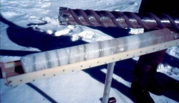
7 Salar de Uyuni 130 m deep at the LGM Baker et al., 2001 Salar de Uyuni drill core sedimentology Salts (halite) Lacustrine Muds Courtesy of Sheri Fritz 7
8 Salar de Uyuni Wet dry cycles 130 m deep lake at the LGM Holocene Eemian Lake Salt pan Courtesy of Sheri Fritz Precipitation during the LGM Titicaca Similar to present Salar de Uyuni La Gaiba Much higher than present Lower than present Modified ecoregion map Olson et al.,

9 Laguna La Gaiba Precipitation during the LGM Titicaca Chaplin Similar to present Salar de Uyuni La Gaiba Much higher than present Lower than present Modified ecoregion map Olson et al.,
 Quaternary Research 61, 215-230. Delta 13 C TOC vs. PDB -30-25 -20-15 0 50 100 Wet?")
10 Noel Kempff Mercado National Park, NE Bolivia Laguna Chaplin Mayle et al. (2000) Science 290, Outline NKMNP Burbridge et al. (2004) Quaternary Research 61, Delta 13 C TOC vs. PDB Wet? 150 LGM


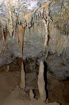
11 Speleothems & travertines, caatinga, NE Brazil LGM Wang et al., 2004 Nature, 432 Auler et al., 2004 JQS, 19 Ice-Age Amazonia was both wet and dry! But Amazon remained forested! 20,000-yr periodicity correlates with the precession orbital cycle change in seasonal amplitude of insolation change in strength of South American summer monsoon LGM Bush et al.,


12 The Holocene Early-Mid Holocene aridity Arid episode between 9 & 3 ka BP Ecotonal areas Modified ecoregion map Olson et al.,
13 Lake Titicaca Umayo satellite image Mid-Holocene lowstand ca. 8,000 to 3,000 yrs ago 90 m below present 6,000 years ago (shown by seismic data) Mid Holocene aridity Delta 13 C TOC vs. PDB


14 Early-mid Holocene aridity Biomass burning 21,000 yr BP to present Northern Bolivia, Sep 14 th 2004 Courtesy of Yadvinder Malhi 14
15 High-frequency climatic oscillations & inter-hemispheric teleconnections Holocene record of Lake Titicaca Baker et al., 2005, JQS, 20 Centennial-scale fluctuations in organics Tipping points?? Correlate with North Atlantic SST fluctuations 15
16 Salar de Uyuni Wet dry cycles Synchronous with North Atlantic sea-surface temp oscillations Tipping points?? Holocene Eemian Lake Salt pan Courtesy of Sheri Fritz Speleothems caatinga, NE Brazil Wang et al., 2004, Nature, 432 Millennial-scale glacial pluvial phases Synchronous with: Cold episodes in Greenland & North Atlantic Decreased river runoff in Cariaco Basin Weak East Asian summer monsoon 16

17 Salar de Uyuni Glacial-Holocene transition Wet period synchronous with North Atlantic Younger Dryas cold period? Lake Salt pan Courtesy of Sheri Fritz Laguna La Gaiba Correlative with European Younger Dryas cooling? 17
18 Conclusions The orbital 20-kyr precession cycle drives longterm Amazon climate change via changes to seasonal amplitude of insolation contrasts with 100-kyr eccentricity cycle in mid-high latitudes Short-term (centennial/millennial-scale) climatic variations inter-hemispheric connections Amazonia s climate has never been stable!! Stable Holocene climate in Oxford but high amplitude climate change during Holocene in Amazonia Mid-Holocene aridity best analogue for future mid-21 st C Amazon?? Questions please 18
Glaciers. Clicker Question. Glaciers and Glaciation. How familiar are you with glaciers? West Greenland. Types of Glaciers.
 Chapter 21 Glaciers A glacier is a large, permanent (nonseasonal) mass of ice that is formed on land and moves under the force of gravity. Glaciers may form anywhere that snow accumulation exceeds seasonal
Glaciers. Glacier Dynamics. Glaciers and Glaciation. East Greenland. Types of Glaciers. Chapter 16
 Chapter 16 Glaciers A glacier is a large, permanent (nonseasonal) mass of ice that is formed on land and moves under the force of gravity. Glaciers may form anywhere that snow accumulation exceeds seasonal
Glaciers. Glacier Dynamics. Glacier Dynamics. Glaciers and Glaciation. Types of Glaciers. Chapter 15
 Chapter 15 Glaciers and Glaciation Glaciers A glacier is a large, permanent (nonseasonal) mass of ice that is formed on land and moves under the force of gravity. Glaciers may form anywhere that snow accumulation
Summertime Precipitation Variability and Atmospheric Circulation over the South American Altiplano: Effects of Lake Titicaca and Salar de Uyuni
 Summertime Precipitation Variability and Atmospheric Circulation over the South American Altiplano: Effects of Lake Titicaca and Salar de Uyuni Maura Hahnenberger Oklahoma Weather Center Research Experiences
Friday, November 10, 2017
 Friday, November 10, 2017 Andes and Midlatitude Countries Objective: Summarize the main physical features and regions of the Southern Cone. Identify and locate the urban centers and understand the pattern
Laboratoire Mixte Internacionale GREATICE Glaciers and Water Resources in the Tropical Andes, Climatic and Environmental Indicators
 Laboratoire Mixte Internacionale GREATICE Glaciers and Water Resources in the Tropical Andes, Climatic and Environmental Indicators Phase I 2011-2014 (Results) Phase II 2016-2020 (Perspectives) Álvaro
Latin America. Physical Geography
 Latin America Physical Geography Regions Latin America can be divided into separate regions based on physical geography or cultural geography. Regions If we look at physical geography Latin America has
THE TWENTY FIRST ANNUAL SOUTHERN AFRICA REGIONAL CLIMATE OUTLOOK FORUM MID-SEASON REVIEW AND UPDATE
 STATEMENT FROM THE TWENTY FIRST ANNUAL SOUTHERN AFRICA REGIONAL CLIMATE OUTLOOK FORUM (SARCOF-21) MID-SEASON REVIEW AND UPDATE, SADC HEADQUARTERS, GABORONE, BOTSWANA, 5 8 DECEMBER 2017. SUMMARY The bulk
Glaciers. Valley or Alpine glaciers. Ice sheets. Piedmont - foot of the mountain glaciers. Form in mountainous areas Move downslope in valleys
 Glaciers & Ice Ages Glaciers Valley or Alpine glaciers Form in mountainous areas Move downslope in valleys Ice sheets Move outward from center Continental glaciers - large scale, ice age type. Presently
Development of Sea Surface Temperature in the Baltic Sea in 2009
 Development of Sea Surface Temperature in the Baltic Sea in 2009 Authors: Herbert Siegel and Monika Gerth, Baltic Sea Research Institute Warnemünde (IOW) Key message The development of the sea surface
GEOGRAPHY OF GLACIERS 2
 GEOGRAPHY OF GLACIERS 2 Roger Braithwaite School of Environment and Development 1.069 Arthur Lewis Building University of Manchester, UK Tel: UK+161 275 3653 r.braithwaite@man.ac.uk 09/08/2012 Geography
Name Team Number. 1. The famous question: What percent of Earth's surface is covered by glaciers? A) 5% D) neve
 5% D) neve") Part I: Multiple Choice (30pts) Directions: Please choose the best answer for each question. There is only one correct answer for each question unless otherwise stated. There are 30 questions. Each one
Part I: Multiple Choice (30pts) Directions: Please choose the best answer for each question. There is only one correct answer for each question unless otherwise stated. There are 30 questions. Each one
Glaciers. Chapter 17
 Glaciers Chapter 17 Vocabulary 1. Glacier 2. Snowfield 3. Firn 4. Alpine glacier 5. Continental glacier 6. Basal slip 7. Internal plastic flow 8. Crevasses 9. Glacial grooves 10. Ice shelves 11. Icebergs
The Lesser Antilles. Dominican Republic), and Puerto Rico
, and Puerto Rico") The Caribbean Islands are archipelagoes or groups of islands. The major archipelagoes are: The Greater Antilles - Cuba, Jamaica, Hispaniola (Composed of Haiti and the Dominican Republic), and Puerto Rico
The Caribbean Islands are archipelagoes or groups of islands. The major archipelagoes are: The Greater Antilles - Cuba, Jamaica, Hispaniola (Composed of Haiti and the Dominican Republic), and Puerto Rico
Development of Sea Surface Temperature in the Baltic Sea in 2010
 HELCOM Baltic Sea Environment Fact Sheets 2011 1 Development of Sea Surface Temperature in the Baltic Sea in 2010 Authors: Herbert Siegel and Monika Gerth Baltic Sea Research Institute Warnemünde (IOW)
Origin and Extraction of Andean Salars
 Think Simulation! Adventures in Electrolytes Origin and Extraction of Andean Salars Lithium and Boron Recovery from Salt brines and Salt flats in Chile and Bolivia http://tunari.tripod.com/landscapes.html
ACER 1 -INTIMATE 2 joint workshop on Last Glacial Abrupt Climate Changes and Sea Surface Temperature Response
 ACER 1 -INTIMATE 2 joint workshop on Last Glacial Abrupt Climate Changes and Sea Surface Temperature Response Bordeaux, 2 nd to 6 th October 2011 Château de Castelterrefort, University Bordeaux 1 (Talence)
Fifty-Year Record of Glacier Change Reveals Shifting Climate in the Pacific Northwest and Alaska, USA
 Fact Sheet 2009 3046 >> Pubs Warehouse > FS 2009 3046 USGS Home Contact USGS Search USGS Fifty-Year Record of Glacier Change Reveals Shifting Climate in the Pacific Northwest and Alaska, USA Fifty years
Climate Change and State of Himalayan Glaciers: Issues, Challenges and Facts
 Climate Change and State of Himalayan Glaciers: Issues, Challenges and Facts D.P. Dobhal dpdobhal@wihg.res.in Wadia Institute of Himalayan Geology Dehra Dun Major Issues Are the Himalayan glaciers receding
Geographic Qualities of South America
 Geographic Qualities of South America 1. South America is the fourth largest continent in area. It is located in the Western Hemisphere, lying southwest of North America. Most of South America lies in
I. Types of Glaciers 11/22/2011. I. Types of Glaciers. Glaciers and Glaciation. Chapter 11 Temp. B. Types of glaciers
 Why should I care about glaciers? Look closely at this graph to understand why we should care? and Glaciation Chapter 11 Temp I. Types of A. Glacier a thick mass of ice that originates on land from the
Paso Robles Groundwater Basin: Effects of Geothermal Waters on Water Quality and Availability
 Paso Robles Groundwater Basin: Effects of Geothermal Waters on Water Quality and Availability Jim Rytuba and Daniel Goldstein U.S. Geological Survey, Menlo Park, CA Paso Robles Intake from Lake Nacimiento
Early Andean Civilizations. Origins and Foundations
 Early Andean Civilizations Origins and Foundations Environmental Context Basic divisions: east/west, north/south Mountains, deserts, and rivers Vertical archipelago : adapting to climate diversity based
Latin America. Physical Geography
 + Latin America Physical Geography + I. Landforms A. Caribbean & Central America 1. Mexico is dominated by two mountain chains, collectively called the Sierra Madre. A high plateau is situated in between.
Rainfall Appendix. Summary Statistics of Rainfall Data for Sites in the West-Central Florida. A Simple Conceptualized Rainfall/Discharge Relationship
 Rainfall Appendix Summary Statistics of Rainfall Data for Sites in the West-Central Florida A Simple Conceptualized Rainfall/Discharge Relationship Stream or river flows are, of course, integrally associated
Canon Of Insolation And The Ice-Age Problem By Milankovic (Milankovitch) Milutin READ ONLINE
 Milutin READ ONLINE") Canon Of Insolation And The Ice-Age Problem By Milankovic (Milankovitch) Milutin READ ONLINE If you are searching for a book by Milankovic (Milankovitch) Milutin Canon of Insolation and the Ice-Age Problem
Canon Of Insolation And The Ice-Age Problem By Milankovic (Milankovitch) Milutin READ ONLINE If you are searching for a book by Milankovic (Milankovitch) Milutin Canon of Insolation and the Ice-Age Problem
Chapter 7 Snow and ice
 Chapter 7 Snow and ice Throughout the solar system there are different types of large ice bodies, not only water ice but also ice made up of ammonia, carbon dioxide and other substances that are gases
Dynamic response of glaciers of the Tibetan Plateau to climate change
 Christoph Schneider 1/23 Christoph Schneider Yao, Tandong Manfred Buchroithner Tobias Bolch Kang, Shichang Dieter Scherer Yang, Wei Fabien Maussion Eva Huintjes Tobias Sauter Anwesha Bhattacharya Tino
Long term mass and energy balance monitoring of Nepalese glaciers (GLACIOCLIM project): Mera and Changri Nup glaciers
: Mera and Changri Nup glaciers") Long term mass and energy balance monitoring of Nepalese glaciers (GLACIOCLIM project): Mera and Changri Nup glaciers ICIMOD IRD collaboration Cryosphere team Who? o o o o The cryosphere team of ICIMOD,
Long term mass and energy balance monitoring of Nepalese glaciers (GLACIOCLIM project): Mera and Changri Nup glaciers ICIMOD IRD collaboration Cryosphere team Who? o o o o The cryosphere team of ICIMOD,
THE TWENTY SECOND SOUTHERN AFRICA REGIONAL CLIMATE OUTLOOK FORUM MID-SEASON REVIEW AND UPDATE
 STATEMENT FROM THE TWENTY SECOND SOUTHERN AFRICA REGIONAL CLIMATE OUTLOOK FORUM (SARCOF-22) MID-SEASON REVIEW AND UPDATE, CRESTA MAUN HOTEL, MAUN, BOTSWANA, 13 14 DECEMBER 2018. SUMMARY The bulk of the
GEOSPATIAL ANALYSIS OF GLACIAL HAZARDS PRONE AREAS OF SHIGAR AND SHAYOK BASINS OF PAKISTAN. By Syed Naseem Abbas Gilany
 GEOSPATIAL ANALYSIS OF GLACIAL HAZARDS PRONE AREAS OF SHIGAR AND SHAYOK BASINS OF PAKISTAN By Syed Naseem Abbas Gilany PRESENTATION OUTLINE Introduction Problem Statement / Rationale Objectives Material
Glacial lakes as sentinels of climate change in Central Himalaya, Nepal
 Glacial lakes as sentinels of climate change in Central Himalaya, Nepal Sudeep Thakuri 1,2,3, Franco Salerno 1,3, Claudio Smiraglia 2,3, Carlo D Agata 2,3, Gaetano Viviano 1,3, Emanuela C. Manfredi 1,3,
Using of space technologies for glacierand snow- related hazards studies
 United Nations / Germany international conference on International Cooperation Towards Low-Emission and Resilient Societies Using of space technologies for glacierand snow- related hazards studies Bonn,
2.1 What is the climate like?
 José Medeiros This fact sheet allows you to see how varied the countryside is across Brazil. 2.1 What is the climate like? Most of Brazil is in the Southern Hemisphere, where the seasons are the opposite
Dynamic Planet C Test
 Northern Regional: January 19 th, 2019 Dynamic Planet C Test Name(s): Team Name: School Name: Team Number: Rank: Score: Dynamic Planet B/C Glaciers (87 total points) Multiple choice/fill in the blank (23
Explore Bolivia's Salt Flats & Lakes. 7 Days
 Explore Bolivia's Salt Flats & Lakes 7 Days Explore Bolivia's Salt Flats & Lakes There are few places on Earth as dazzling and dreamlike as Bolivia, South America's landlocked gem. Your quest begins in
TRENDS IN MAXIMUM AND MINIMUM TEMPERATURE IN THE CENTRAL ANDES OF PERU (MANTARO RIVER BASIN)
") TRENDS IN MAXIMUM AND MINIMUM TEMPERATURE IN THE CENTRAL ANDES OF PERU (MANTARO RIVER BASIN) Grace Trasmonte *, Yamina Silva, Raúl Chavez and Berlin Segura Instituto Geofísico del Perú ABSTRACT * 1 1.
TRENDS IN MAXIMUM AND MINIMUM TEMPERATURE IN THE CENTRAL ANDES OF PERU (MANTARO RIVER BASIN) Grace Trasmonte *, Yamina Silva, Raúl Chavez and Berlin Segura Instituto Geofísico del Perú ABSTRACT * 1 1.
A funny sounding lake. South American Landforms, Climate, and Vegetation
 A funny sounding lake South American Landforms, Climate, and Vegetation 3 4 Essential Question: How have physical features and climate affected the population distribution of Latin America? 5 I. Landforms
ANDEX: A Regional Hydrology Program for the Andes
 ANDEX: A Regional Hydrology Program for the Andes Silvina Solman CIMA (CONICET-UBA) - Universidad de Buenos Aires Argentina Germán Poveda Universidad Nacional de Colombia, Medellín Colombia TPE-GHP/GEWEX
LAST TIME (Happy 300 th Birthday Ben Franklin!)
") LAST TIME (Happy 300 th Birthday Ben Franklin!) Latin American Diversity: Introduction Physical Geography of Mexico, Caribbean, and Central America: 1. Mexican drylands 2. Mesoamerican Highlands 3. Coastal
LAST TIME (Happy 300 th Birthday Ben Franklin!) Latin American Diversity: Introduction Physical Geography of Mexico, Caribbean, and Central America: 1. Mexican drylands 2. Mesoamerican Highlands 3. Coastal
ENVIRONMENTAL HAZARDS OF AVALANCHES: PRELIMINARY RESEARCH IN GLACIER NATIONAL PARK
 ENVIRONMENTAL HAZARDS OF AVALANCHES: PRELIMINARY RESEARCH IN GLACIER NATIONAL PARK Site Focus: Balu Pass, Glacier National Park, B.C. Avalanche path near Balu Pass. (Photo Courtesy of: www.leelau.net/2007/rogerspass/day1/1)
Community resources management implications of HKH hydrological response to climate variability
 Community resources management implications of HKH hydrological response to climate variability -- presented by N. Forsythe on behalf of: H.J. Fowler, C.G. Kilsby, S. Blenkinsop, G.M. O Donnell (Newcastle
GRANDE News Letter Volume1, No.4, March 2013
 GRANDE News Letter Volume1, No.4, March 2013 New technologies for the study of tropical glaciers Prof. Edson RAMIREZ Institute of Hydraulics and Hydrology, Universidad Mayor de San Andres, Bolivia Techniques
APPENDIX E GLACIERS AND POLAR ICE CAPS
 APPENDIX E GLACIERS AND POLAR ICE CAPS GLACIERS The dictionary defines a glacier as a large mass of ice and snow that forms in areas where the rate of snowfall constantly exceeds the rate at which the
Seasonal Variability of the Groundwater Regime for Several Aquifers in Bulgaria Tatiana Orehova 1
 Seasonal Variability of the Groundwater Regime for Several Aquifers in Bulgaria Tatiana Orehova 1 The purpose of the paper is to analyse the seasonal variability of the groundwater regime for several aquifers
4 *Contours generalized for estimating average watershed precipitation; adopted from larger map by Geomatrix, 1999.
 Selected USGS Stream Gaging Stations San Lorenzo River watershed A. Pescadero Ck B. San Lorenzo R. Waterman Switch C. Boulder Ck D. Zayante Ck E. Bean Ck F. San Vicente Ck G. San Lorenzo R. at Big Trees
Snow, Glacier and GLOF
 Snow, Glacier and GLOF & Report on Demonstration River Basin Activities Upper Indus Basin The 5th International Coordination Group (ICG) Meeting GEOSS Asian Water Cycle Initiative (AWCI) Tokyo, Japan,
ESS Glaciers and Global Change
 ESS 203 - Glaciers and Global Change Friday January 5, 2018 Outline for today Please turn in writing assignment and questionnaires. (Folders going around) Questions about class outline and objectives?
Integration Of Reflectance To Study Glacier Surface Using Landsat 7 ETM+: A Case Study Of The Petermann Glacier In Greenland
 Integration Of Reflectance To Study Glacier Surface Using Landsat 7 ETM+: A Case Study Of The Petermann Glacier In Greenland Félix O. Rivera Santiago Department Of Geology, University Of Puerto Rico, Mayaguez
Rapid decrease of mass balance observed in the Xiao (Lesser) Dongkemadi Glacier, in the central Tibetan Plateau
 Dongkemadi Glacier, in the central Tibetan Plateau") HYDROLOGICAL PROCESSES Hydrol. Process. 22, 2953 2958 (2008) Published online 8 October 2007 in Wiley InterScience (www.interscience.wiley.com).6865 Rapid decrease of mass balance observed in the Xiao
HYDROLOGICAL PROCESSES Hydrol. Process. 22, 2953 2958 (2008) Published online 8 October 2007 in Wiley InterScience (www.interscience.wiley.com).6865 Rapid decrease of mass balance observed in the Xiao
Glaciers and Glaciation Earth - Chapter 18 Stan Hatfield Southwestern Illinois College
 Glaciers and Glaciation Earth - Chapter 18 Stan Hatfield Southwestern Illinois College Glaciers Glaciers are parts of two basic cycles: 1. Hydrologic cycle 2. Rock cycle A glacier is a thick mass of ice
Measures of Urban Trail Use in Minneapolis
 Measures of Urban Trail Use in Minneapolis Midtown Greenway @ Hennepin Ave Midtown Greenway @ Cedar Ave Midtown Greenway @ West River Pkwy Lake Calhoun Pkwy trail Why Measure Trail Use? Document use of
Testing Results of the Ecocina Cooking Stove from El Salvador By Nordica MacCarty March 5th, 2008
 Testing Results of the Cooking Stove from El Salvador By Nordica MacCarty March 5th, 28 Introduction The Stove, developed by Larry Winiarski and Nancy Hughes, was received at the Aprovecho laboratory in
Impacts of climate change on the hydrological processes in the Mekong River. Hui Lu & Wei Wang Tsinghua University
 1 Impacts of climate change on the hydrological processes in the Mekong River Hui Lu & Wei Wang Tsinghua University Outline Backgrounds Method and data Model calibration Temperature and rainfall trends
RESPONSE OF RANDOMIZED SUBSETS OF RAINFALL GAUGES OVER A PARANÁ RIVER SUB-BASIN
 RESPONSE OF RANDOMIZED SUBSETS OF RAINFALL GAUGES OVER A PARANÁ RIVER SUB-BASIN Thais Fujita, A. P. Rudke, M. V. B. de Morais, S. A. A. Rafee, R. A. F. de Souza, R. V. A. de Souza, E. D. de Freitas, L.
Considerations for the Long-Term Atmospheric Observing Network
 Considerations for the Long-Term Atmospheric Observing Network 1. Land Cover / Land Use & Change 2. Spatial & temporal scale of climate anomalies 3. Climatological wind patterns 4. Expected signals vs.
Habitat of Large Glaciers and Snow Leopards
 Headwaters of High Mountain Asia - Habitat of Large Glaciers and Snow Leopards International Snow Leopard Day A Collaborative Effort to Assess the Role of Glaciers and Seasonal Snow Cover in the Hydrology
Serengeti Fire Project
 Serengeti Fire Project Outline Serengeti Fire Project Colin Beale, Gareth Hempson, Sally Archibald, James Probert, Catherine Parr, Colin Courtney Mustaphi, Tom Morrison, Dan Griffith, Mike Anderson WFU,
Glaciers and Glaciation
 Chapter 18 Lecture Earth: An Introduction to Physical Geology Eleventh Edition Glaciers and Glaciation Tarbuck and Lutgens Glaciers: A Part of Two Basic Cycles A glacier is a thick mass of ice that forms,
Assessment of glacier water resources based on the Glacier Inventory of China
 104 Annals of Glaciology 50(53) 2009 Assessment of glacier water resources based on the Glacier Inventory of China KANG Ersi, LIU Chaohai, XIE Zichu, LI Xin, SHEN Yongping Cold and Arid Regions Environmental
South American Countries. Capital Location Population Terrain Climate
 South American Countries Capital Location Population Terrain Climate Andes Mountains Four large areas that make up the Central Plains: Llanos, the Selva, the Gran Chaco, and the Pampas Brazilian Highlands
A Comparison of the Salar de Atacama and Clayton Valley Lithium Ore Deposits: Groundwater Mining in the some of the Driest Places on Earth
 A Comparison of the Salar de Atacama and Clayton Valley Lithium Ore Deposits: Groundwater Mining in the some of the Driest Places on Earth Melissa Jennings Geologist & Environmental Engineer This presentation
The impact of climate change on glaciers and glacial runoff in Iceland
 The impact of climate change on glaciers and glacial runoff in Iceland Bergur Einarsson 1, Tómas Jóhannesson 1, Guðfinna Aðalgeirsdóttir 2, Helgi Björnsson 2, Philippe Crochet 1, Sverrir Guðmundsson 2,
DOWNLOAD OR READ : MAPPING SOUTH AMERICA PDF EBOOK EPUB MOBI
 DOWNLOAD OR READ : MAPPING SOUTH AMERICA PDF EBOOK EPUB MOBI Page 1 Page 2 mapping south america mapping south america pdf mapping south america South America PDF maps Free South America maps for students,
ECORREGIONAL ASSESSMENT: EASTERN CORDILLERA REAL ORIENTAL PARAMOS AND MONTANE FORESTS
 ECORREGIONAL ASSESSMENT: EASTERN CORDILLERA REAL ORIENTAL PARAMOS AND MONTANE FORESTS The Nature Conservancy, EcoCiencia y Fundación AGUA. 2005. Evaluación Ecorregional de los Páramos y Bosques Montanos
A high resolution glacier model with debris effects in Bhutan Himalaya. Orie SASAKI Kanae Laboratory 2018/02/08 (Thu)
") A high resolution glacier model with debris effects in Bhutan Himalaya Orie SASAKI Kanae Laboratory 2018/02/08 (Thu) Research flow Multiple climate data at high elevations Precipitation, air temperature
A high resolution glacier model with debris effects in Bhutan Himalaya Orie SASAKI Kanae Laboratory 2018/02/08 (Thu) Research flow Multiple climate data at high elevations Precipitation, air temperature
The palaeohydrology of the Late Pleistocene Lake Tauca on the Bolivian Altiplano and recent climatic fluctuations
 Sonderdrucke aus der Albert-Ludwigs-Universität Freiburg ALBRECHT KESSLER The palaeohydrology of the Late Pleistocene Lake Tauca on the Bolivian Altiplano and recent climatic fluctuations Originalbeitrag
Status of Mangroves in Belize
 Status of Mangroves in Belize State of the Coastal zone Summit June 7 th 2012 Nadia Bood*, Emil Cherrington and Tim Smith Outline Introduction to mangroves Importance of mangrove to Belize National status
Load-following capabilities of nuclear power plants
 Downloaded from orbit.dtu.dk on: Sep 18, 2018 Load-following capabilities of nuclear power plants Nonbøl, Erik Publication date: 2013 Link back to DTU Orbit Citation (APA): Nonbøl, E. (2013). Load-following
KAYAKING LAKE TITICACA
 KAYAKING LAKE TITICACA FROM $520 4 days / 3 nights MODERATE TRIP Knowmad specializes in private and custom travel. Itineraries and physical difficulty are often flexible. TRIP HIGHLIGHTS Kayak to remote
Part 1 Glaciers on Spitsbergen
 Part 1 Glaciers on Spitsbergen What is a glacier? A glacier consists of ice and snow. It has survived at least 2 melting seasons. It deforms under its own weight, the ice flows! How do glaciers form? Glaciers
Terminal Archaic Settlement Pattern and Land Cover Change in the Rio Ilave, Southwestern Lake Titicaca Basin, Perú
 From the SelectedWorks of Nathan M Craig 2010 Terminal Archaic Settlement Pattern and Land Cover Change in the Rio Ilave, Southwestern Lake Titicaca Basin, Perú Nathan M Craig, Pennsylvania State University
Section 2 North Slope Ecoregions and Climate Scenarios
 Section 2 North Slope Ecoregions and Climate Scenarios North Slope Ecoregions The geographic/ecological scope of the workshop will be freshwater and terrestrial systems of the North Slope of Alaska, with
Geomorphology. Glacial Flow and Reconstruction
 Geomorphology Glacial Flow and Reconstruction We will use simple mathematical models to understand ice dynamics, recreate a profile of the Laurentide ice sheet, and determine the climate change of the
The 2nd Glacier Inventory of China
 The 2nd Glacier Inventory of China LIU Shiyin Guo Wanqin, Xu Junli, Shangguan Donghui, Wei Junfeng, Wu Lizong, Yu Pengchun, Li Jing, Liu Qiao State Key Laboratory of Cryospheric Sciences, Cold and Arid
THE PHYSICAL AND CULTURAL GEOGRAPHY OF SOUTH AMERICA
 THE PHYSICAL AND CULTURAL GEOGRAPHY OF SOUTH AMERICA 1 Global location Relative to European capitals Relative to US cities Time zones Two oceans Pacific rim countries - farther to Asia than USA Not on
Single and mass avalanching. Similarity of avalanching in space.
 Single and mass avalanching. Similarity of avalanching in space. Pavel Chernous* Center for Avalanche Safety, "Apatit" JSC, Kirovsk, Russia ABSTRACT: Sometimes it is possible to observe only single avalanche
The Geography of Climate
 The Geography of Climate Objective for Today: Today we will examine ways that latitude and landforms influence climate The focus of our study will be the South American Continent in the Formal Region known
Latin America. Chapter 9 Physical Geography
 Latin America Chapter 9 Physical Geography Latin American Regions Middle America includes Mexico and the Central American countries The Caribbean Islands South America Mexico Landforms Sierra Madre Oriental
One World Lithium Inc. (OWL) is a lithium exploration company that is a compelling investment opportunity with its Salar del Diablo lithium property:
 is a lithium exploration company that is a compelling investment opportunity with its Salar del Diablo lithium property:") One World Lithium Inc. (OWL) is a lithium exploration company that is a compelling investment opportunity with its Salar del Diablo lithium property: The Salar del Diablo is a 75,000 hectare lithium property
One World Lithium Inc. (OWL) is a lithium exploration company that is a compelling investment opportunity with its Salar del Diablo lithium property: The Salar del Diablo is a 75,000 hectare lithium property
Integrated remote and in situ analysis of a playa lake groundwater system in northern Chile. Katherine H. Markovich The University of Texas at Austin
 Integrated remote and in situ analysis of a playa lake groundwater system in northern Chile Katherine H. Markovich The University of Texas at Austin Hydrogeology of Arid Environments March 15 th, 2012
Long term Forecast of Glaciation and Evaluation of Glacial Resources of the Central Asia with the Use of Isotopic Methods
 Long term Forecast of Glaciation and Evaluation of Glacial Resources of the Central Asia with the Use of Isotopic Methods Vladimir I. SHATRAVIN, Tamara V. TUZOVA, Institute of Water Problems and Hydropower
ICPAC. IGAD Climate Prediction and Applications Centre Monthly Bulletin, February 2017
 IGAD CLIMATE PREDICTION AND APPLICATIONS CENTRE ICPAC Bulletin Issue March 2017 Issue Number: ICPAC/02/299 IGAD Climate Prediction and Applications Centre Monthly Bulletin, February 2017 For referencing
Escalating Queensland Bushfire Threat: Interim Conclusions
 Escalating Queensland Bushfire Threat: Interim Conclusions Authors: Professor Lesley Hughes, Greg Mullins, Dr Martin Rice and Dr Annika Dean. Introductory note: The Climate Council will publish a report
VOLUME CHANGES OF THE GLACIERS IN SCANDINAVIA AND ICELAND IN THE 21st CENTURY
 VOLUME CHANGES OF THE GLACIERS IN SCANDINAVIA AND ICELAND IN THE 21st CENTURY Valentina Radić 1,3 and Regine Hock 2,3 1 Depart. of Earth & Ocean Sciences, University of British Columbia, Vancouver, Canada
Andean uplift and Atacama hyper-aridification: A climate modeling perspective + some new ideas to test
 Andean uplift and Atacama hyper-aridification: A climate modeling perspective + some new ideas to test 0 S 30 S René Garreaud 1, Alejandra Molina 1, Marcelo Farias 2 (1) Departamento de Geofísica (2) Departamento
Chapter 17. North Africa, Southwest Asia and Central Asia
 Chapter 17 North Africa, Southwest Asia and Central Asia Chapter Objectives Describe the major landforms and natural resources of North Africa, Southwest Asia, and Central Asia. Discuss the climate and
Thermal efficiency improvement and technology transfer of chimney stove for producing stove; Amphoe Bo Kluea, Nan Province
 Available online at www.sciencedirect.com Energy Procedia 9 (2011 ) 238 244 9 th Eco-Energy and Materials Science and Engineering Symposium Thermal efficiency improvement and technology transfer of chimney
THE ANDEAN AREA....How does the rich countries development affect some poor and 1. distant countries
 THE ANDEAN AREA...How does the rich countries development affect some poor and 1 distant countries 1. Geographical situation of the Andean area South America view 2 Andes mountain range Amazonian basin
Water masses and circulation in the North Atlantic
 Ocean and Climate Change, March 30, 2012, Paris Water masses and circulation in the North Atlantic Monika Rhein, Universität Bremen Dagmar Kieke, Christian Mertens, Achim Roessler, and Reiner Steinfeldt
Maine Puffins Rebound
 Maine Puffins Rebound Cooler water and more phytoplankton in spring of 2014 favor return of favorite forage fish Maine puffins experienced a dramatic increase in nesting success in 2014 following two years
GEOGRAPHY OF THE WESTERN HEMISPHERE
 GEOGRAPHY OF THE WESTERN HEMISPHERE LEARNING LOG Write clear directions that describe how to get from one place to another. Choose 2 locations that other people might not know about. Did you use a map
UNIT 5 PHYSICAL GEOGRAPHY SG 1 - PART I
 UNIT 5 PHYSICAL GEOGRAPHY SG 1 - PART I Africa is HUGE! I. LANDFORMS A. Plateaus - an area of relatively level high ground. 1. Africa s interior is dominated by series of plateaus and elevated basins such
YALE PEABODY MUSEUM OF NATURAL HISTORY. Number 69 October 10, 1962 New Haven, Conn. NOTES ON SOUTH AMERICAN FLAMINGOS. Luis E. PENA* INTRODUCTION
 YALE PEABODY MUSEUM OF NATURAL HISTORY Number 69 October 10, 1962 New Haven, Conn. NOTES ON SOUTH AMERICAN FLAMINGOS Luis E. PENA* INTRODUCTION During the Chilean winter of 1957 we had our first contact
J.M.Alveirinho Dias * R. Gonzalez * Ó. Ferreira * * Universidade do Algarve Faculdade de Ciências do Mar e do Ambiente
 J.M.Alveirinho Dias * R. Gonzalez * Ó. Ferreira * * Universidade do Algarve Faculdade de Ciências do Mar e do Ambiente 4ª bacia hidrográfica (em área) da Península Ibérica Area: 66 960 km 2 Comprimento:
Statistical Evaluation of BMP Effectiveness in Reducing Fecal Coliform Impairment in Mermentau River Basin
 Statistical Evaluation of BMP Effectiveness in Reducing Fecal Coliform Impairment in Mermentau River Basin Z.-Q. Deng 1 and H. Chowdhary 2 1 Assistant Professor, Department of Civil and Environmental Engineering,
Analysis of Sea Turtle Nest Temperatures and Future Global Warming Effects on Two Coasts of Mexico
 Analysis of Sea Turtle Nest Temperatures and Future Global Warming Effects on Two Coasts of Mexico Nick Furst, Allison Baxter, Armando Lorences Camargo, Carla Cristina Sanchez Salazar, Katherine Comer
Glaciers Earth Chapter 18 Chapter 18 Glaciers & Glaciation Glaciers: A Part of Two Basic Cycles Glaciers: A Part of Two Basic Cycles Valley Glacier
 1 2 3 4 5 6 7 8 9 10 11 12 Glaciers Earth Chapter 18 Chapter 18 Glaciers & Glaciation A glacier is a thick mass of ice that forms, over hundreds and thousands of years, by the accumulation, compaction,
Observation of cryosphere
 Observation of cryosphere By Sagar Ratna Bajracharya (email: sagar.bajracharya@icimod.org) Samjwal Ratna Bajracharya Arun Bhakta Shrestha International Centre for Integrated Mountain Development Kathmandu,
Actual Climatic Conditions in ERB. Online Resource 1 corresponding to:
 Actual Climatic Conditions in ERB. Online Resource 1 corresponding to: Article Title: Climatic Trends and Impact of Climate Change on Agriculture in an Arid Andean Valley. Journal Name: CLIMATIC CHANGE