AMETHYST BRAZIL & URUGUAY. ENTICEMENT The Draw of. Reinhard Balzer Germany. Brazil & Uruguay 23
|
|
|
- Chester Mervin Flynn
- 6 years ago
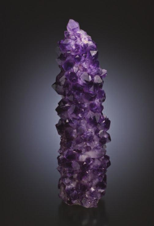
- Views:
Transcription

1 22 AMETHYST
 Michael Bainbridge photo Brazil & Uruguay 23")
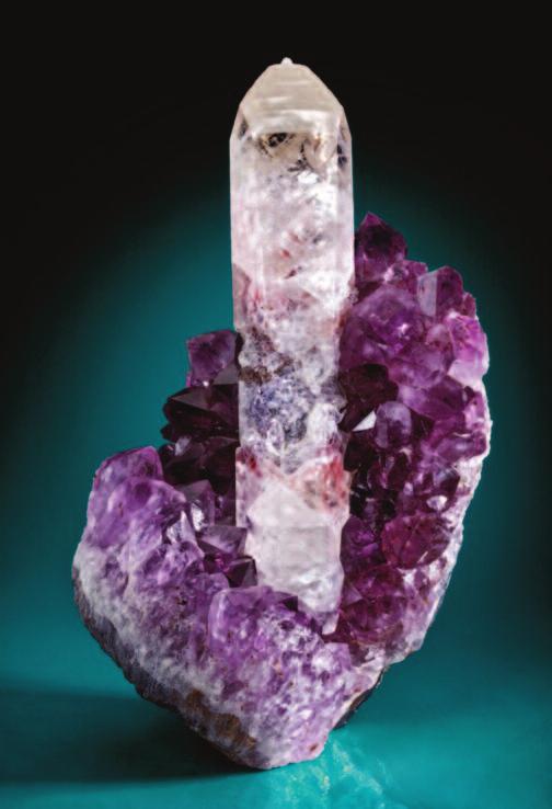
2 AMETHYST ENTICEMENT The Draw of BRAZIL & URUGUAY Reinhard Balzer Germany Amethyst-lined cavity, 39 cm wide Rio Grande do Sul, Brazil Canadian Museum of Nature collection (Cat. No. CMN 52998) Michael Bainbridge photo Brazil & Uruguay 23
 attracted many Germans, particularly those from the Hunsrück, Eifel, and Palatinate")

3 Brazil gained its independence from Portugal in A huge realm, now the largest country in South America, Brazil sought European immigrants to help settle the enticing country overseas. The thinly populated country, with virgin, primeval forests and a mild climate (at least in the southern provinces) attracted many Germans, particularly those from the Hunsrück, Eifel, and Palatinate mountain regions, to which decades of war, robbery, pillage had brought endless suffering. Brazil was new territory: farming, handicraft, trade could unfold freely there. In their wake, science, art, and culture also blossomed. The country had an open class system, and did not levy the same excruciating taxes as were charged in Europe. Farmers without land were allocated a plot as well as start-up capital and the seeds to grow their first crops. Individuals were the masters of the land that their own work had cultivated. German laborers and farmers left their homeland in droves to build a new life in the Brazilian promised land. After many years of arduous work and a lifestyle that was distinctive for its deprivation, most of the immigrants were rewarded, for the fertile land in Brazil brought above-average yields, and the mountains abounded in raw materials, including gemstones. The first Brazilian states in which Europeans found gem deposits were Rio Grande do Sul, Minas Gerais, Bahia, and Espírito Santo. The finds were like a gift from heaven for the lapidary industry in Hunsrück, Above: Life was not easy for the nineteenth century immigrants who came to South America to seek freedom and fortune. The conditions are exemplified in this circa 1923 photo of a miner s shelter in Uruguay. Rheinhard Balzer collection Right: Map of South America; William Besse cartography 24 AMETHYST

4 The various lava sheets the vast Paraná Basin have different makeups and thus erode at different rates, making for some dramatic, stepped waterfalls such as the world famous 1.7- kilometer-long Cataratas do Iguaçu on the border between Argentina and Brazil. Marcio Cabral photo, 2010 suffering as it was from a lack of raw materials. Consequently many young people from the gemstone carving and cutting center of Idar-Oberstein (page xx) were drawn to Brazil to secure rough material for processing back in the old country. GEOLOGY The gem deposits had been evolving since ancient times. Some 200 million years ago in the early Jurassic, the southern hemisphere was dominated by the Gondwana supercontinent. About 185 million years ago, Gondwana began to break up, and the modern day landmasses of South America and Africa slowly separated as the southern Atlantic Ocean opened. The opening of the ocean was accompanied by a massive outpouring of flood basalts, which began around 135 million years ago. These basalts can be found in South America s Paraná Basin and Africa s Kalahari Basin (in Namibia). In South America the basalts extend across the Brazilian states of Rio Grande do Sul, Santa Catarina, Paraná, São Paulo, Mato Grosso do Sul, and portions of Minas Gerais, as well as parts of Uruguay, Paraguay, and Argentina. The scale of the flood basalts is impressive: they cover some 1.2 million square kilometers an area 3½ times larger than that of Germany! Their total volume is estimated to be at least 1.8 million cubic kilometers. The basalts are made up of layers of individual flows, some up to 100 meters thick, that record a 10-million-year eruptive history. Earlier studies suggested that circulating hydrothermal waters driven by the cooling of the thick lava pile precipitated the amethyst, but as described by Dr. Gilg on page xx, the infilling of the geodes has been shown to have occurred long after and quite independently of the cooling of the host lava. Mineral deposition is more likely related to tectonic events that ultimately flooded the basalts with seawater. The seawater leached the various minerals, including silicon dioxide (SiO 2 ), from the basalts and upon crystallization produced fine-grained, cryptocrystalline chalcedony and agate. The fine-grained silica was often reactivated and redeposited as larger crystals, including amethyst. In addition to silica, cavities in the basalt host a suite of other minerals including calcite, gypsum, anhydrite, barite, goethite, and various zeolites. Through history the cavities were pulsed with fluids, resulting in an abundance of pseudomorphs as one mineral was replaced by another. The pockets are typified by green to blue-green clinochlore rinds, which are covered with a microcrystalline layer of quartz or chalcedony, and then lined with larger crystals. Quartz crystals occur in a variety of colors, but amethyst dominates. Individual basalt flood events were separated in time by hundreds of thousands of years, and the weathering of the surface during quiet times resulted in a sedimentary horizon that was often covered by subsequent flood basalts. These sedimentary layers are rich in quartz pods and opal. It is not well understood why the flood basalts in the Paraná Basin in South America are an order of magnitude larger than those in the Kalahari Basin in Africa. One theory suggests that after the Gondwana breakup and separation, Africa moved more swiftly away from the fixed hotspot, or mantle plume, which was responsible for the flood basalts, than did the continental mass of South America. The volcano above the hotspot is active today. It is situated on the island of Tristan da Cunha on the mid-oceanic ridge. Brazil & Uruguay 25

5 THE SEARCH FOR PRECIOUS STONES IS ON! Legend has it that in 1827 the son of one of the stonecutters who had emigrated from Idar-Oberstein happened upon some agate pebbles in a riverbed in Rio Grande do Sul. The find was a godsend for the cutters in the old country because toward the end of the eighteenth century, their local stocks of agate rough had been depleted. The first consignment of agate material was shipped over the Atlantic in Initially it was considered dead weight, since at the time there were few cargo shipments for Europe. Later it became regular freight, which was offloaded to barges and transported up the Rhine and Mosel rivers, then carried by oxcart to Idar-Oberstein. The finds in Brazil not only rescued but also revived the industry in Idar-Oberstein, helping to make the region the international carving and cutting center that it is today. Gemstone cutters from the Hunsrück region sailed to Brazil to secure sources of raw materials. The ensuing systematic exploration resulted in discoveries not only of the much-sought agates but also of large amethyst deposits. And it was not long before even more valuable gemstones the aquamarine and emerald varieties of beryl, tourmalines to span the spectrum, spodumene, topazes, and even diamonds were discovered in Brazil s northern states. Prospecting quickly led to finds in the adjacent Provincia Oriental, which is present-day Uruguay. A German scientist, Dr. Sellow, was among the first to find agate and amethyst in the province. Unfortunately, the precise knowledge of the localities was lost when Sellow drowned while he was traveling through the province. The deposits in Uruguay were later rediscovered in 1857 by August Becker (Falz, von Menschen, and Steinen 1939). The fact that some amethyst can be heated to create the saturated yellow quartz variety citrine has been known since ancient times, but was anecdotally discovered in Brazil in the early 1880s. Legend has it that German August Lamberts and a group of other Idar-Oberstein prospectors were in Brazil in search of cutting material. The group used pieces of amethyst to contain their campfire and woke in the morning to find that the amethyst had changed from purple to yellow. The process of heating amethyst to produce citrine has since become a commercial enterprise; the formulas for burn times and temperatures are trade secrets. MINING DISTRICTS The amethyst that has made the region famous comes primarily from three districts. The Médio Alto Uruguai district crosses the Brazilian state of Rio Grande do Sul, reaches into the state of Santa Catarina, and includes the towns of Frederico Westphalen, Iraí, Ametista do Sul, Planalto, Rodeio Bonito, and Trindade do Sul. The Salto de Jacuí district encompasses the mines at Campos Borges, Salto de Jacuí, and Santa Maria and around Espumoso, and Soledade. The Fronteira Sudoeste district includes the area 26 AMETHYST


6 Upper left: Quartz variety amethyst on calcite, 5 cm tall Dos Irmaos, Bortoluzzi, Iraí, Rio Grande do Sul, Brazil Christian Weise collection Jeff Scovil photo Upper right, middle right: Amethyst gems cut from rough from Rio Grande Do Sul, Brazil The upper carat stone is amethyst heated treated to citrine; the lower carat stone was cut from natural amethyst. Both stones are in the collection of Ekkehard Schneider; both are Jeff Scovil photos. Right: Amethyst heat-treated to citrine, field of view 6 cm wide Rio Grande do Sul, Brazil Herb Obodda collection Jeff Scovil photo Facing page: Agate and Amethystlined cavity, xx cm wide Rio Grande do Sul, Brazil Canadian Museum of Nature collection (Cat. No. CMN 52998) Michael Bainbridge photo Brazil & Uruguay 27

7 around the Rio Grande do Sul town of Quaraí and the famous Artigas Mine in Uruguay s Artigas Department. Agate and amethyst deposits are strewn throughout the Paraná Basin; it is thus difficult to assess the economic reserves. There are, however, patterns: mining concentrates primarily on amethyst geodes in the Médio Alto Uruguai and Fronteira Sudoeste, and agate geodes are targeted in the central Salto de Jacuí district. MINING IN THE TWENTIETH CENTURY In spite of the richness of the deposits, business between Hunsrück and southern Brazil was frustratingly bipolar between from 1860 to Numerous uprisings and civil wars in South America, problems between Germany and France that culminated in Franco-Prussian War of 1870, then World War I and the ensuing inflation interrupted the trade between central European and South America. But between the times of strife, the bounty of the New World flowed. During the first third of the twentieth century, the Uruguayan peso was one of the hardest currencies in the world. It was even more stable than the U.S. dollar, prompting people to refer to Uruguay as the Switzerland of South America. However, given the slow means of communication between the two continents, the shifting political climates in both Uruguay and Germany, and the Above: Regular Zeppelin service between Germany and Brazil in the 1930s eased travel and communication between traders in the old and new worlds. Right: Map of the Brazilian state of Rio Grande do Sul and the country of Uruguay, and that country s Artigas department The major amethyst mining regions Medio Alto Uruguai, Salto de Jacui, and Fronteira Sudoeste and principle mining towns are indicated. Bill Besse cartography (after Besse and Currier, 1997) Facing page, upper: An emu investigates a pile of agate geodes Reinhard Balzer photo, 2007 Facing page, lower: A river divides the road en route to the mines Reinhard Balzer photo, 2007 tina Salto nos Aires Uruguaiana Quarai Artigas Departement Artigas Paysandú Colonia Uruguay Minas Montevideo Irai Brazil Ametista do Sul Soledade Rio Grande do Sul State Porto Alegre Santana do Livramento Melo Punta del Este 0 50 km 28 AMETHYST


8 fluctuating German and U.S. currencies, it was all but impossible for Germans and Uruguayans to engage in meaningful trade. As a result only people who owned the land on which stones were found were able to sustain regular exports. This portion of the population included a few German families and companies, but many of the Germans living in Uruguay slipped into poverty. In time, however, catapult aircraft and the Zeppelin brought airmail, and the telegraph connected the two countries. As a result, it became easier to react to market changes and more effectively negotiate prices. While communication between the continents improved, the infrastructure within South America remained primitive. There were no roads or bridges. In the wet and rainy season, it was impossible to reach the mines. The beginning of the twentieth century saw the first automobiles and even a regular bus route between Artigas and the border city of Rivera; yet horses, donkeys, and ox-carts were still the most common means of transport. MINING TODAY These days reaching the mines in and around the provincial capital of Artigas is relatively easy. There are flights from the Uruguayan capital of Montevideo and from Porto Alegre in Brazil. Good roads connect Artigas to the established mines in neighboring Rio Grande do Sul. But access to many of the mines such as Catalan Grande, Catalan Chico, and Tres Cerros in the 100 square kilometers around the Catalan River southeast of Artigas requires all-wheel drive vehicles with high clearance. The mines in the Catalan region are reached by dirt spurs off of the main paved road from Artigas. The spurs are impassable during the rainy season as the bridgeless Catalan Grande and Catalan Chico rivers are too high to cross. When water levels are low or the rivers dry, however, small to medium-sized geodes and tumbled agate, amethyst, and other quartz varieties litter the riverbeds and tracks. To reach many areas, it is necessary to cross pastures and private property. Permission to cross or collect on private property and respect for local laws and customs are obviously required. Developing a mine in this region is difficult, costly, and time consuming. Prospective miners must first negotiate permission from landowners and then gain consent from the appropriate environmental and mining authorities. Only then can roads be built and the appropriate equipment brought in. Open pits are dug to recover crystals and agate from the weathered basalts. But amethyst-lined vugs and agate nodules Brazil & Uruguay 29


9 30 AMETHYST Above: Huge tunnels are driven into the lava sheets at the La Bolsa Mine Reinhard Balzer photo, 2004 Left: A cavity is illuminated so that it can be assessed Reinhard Balzer photo, 2004 Below: A amethyst-lined cavity frozen in solid basalt Reinhard Balzer photo, 2004 Facing page, upper: A man-sized crystal-lined cavity, which has been extracted intact, Reinhard Balzer photo, 2004 Facing page, lower: Mineral dealer Rock Currier stands in a warehouse full of amethyst cathedrals Photo courtesy of Rock Currier, year?
, from the matrix.")

10 are also found solidly enveloped in unweathered basalt. To extract these, horizontal tunnels are driven into the lava sheets to reach the geodes. Explosives loosen the rock, but drills, hammers, and chisels are used to release crystal-lined cavities, locally referred to as druses (see page xx), from the matrix. The waste rock is tipped onto the rock pile in front of the mine. To keep the path to the dumpsite short, several gallery entrances are driven, one next to the other. Inside massive props secure the mine. Once a druse has been partially freed, a small hole is drilled into it, and it is illuminated to enable a miner to evaluate the quality and decide whether it is worth the cost of careful extraction or whether it should be quickly broken up and removed in pieces for sale as rough or as wholesale material. If the druse is to be extracted intact, it is opened and stabilized. Minor damage and the initial drill hole are repaired with suitable crystal tips. Of the broken material, crystal tips to be used or sold as gem rough are broken out of the host stone and sorted by color and size. They are then chipped to remove the parts of the crystal that are unsuitable for faceting. Non-gemmy portions of larger crystals are removed with a diamond saw. In order to evaluate the quality of the various pieces, everything first has to be cleaned. In general this is done chemically, under supervision of factory management in the town. Repairs are also carried out at the factory. The repair processes are not always in keeping with what collectors generally find acceptable, so it is important to inquire about repairs before making a purchase. Brazil & Uruguay 31

11 32 AMETHYST

12 From the Famous Artigas Department in Uruguay Right: Polished cross section of an amethyst stalactite, 21 cm tall Tim and Holly Smith collection Holly Smith photo Facing page, upper: Quartz variety amethyst encrusting and associated with calcite 14.6 cm wide Santiño Mine Helmut Brückner collection Jeff Scovil photo Facing page, lower left: Calcite on amethyst, 20.5 cm tall Santiño Mine Stonetrust specimen Joe Budd photo Facing page, lower right: Amethyst pseudomorph after calcite stalactite, 14.3 cm tall Scott Rudolph collection Jeff Scovil photo In earlier times prospecting was mainly concentrated on agates and amethysts that were worked into jewelry. Today, however, there is a huge market for decorative formations derived from the various stages of mineralization. For decades, miners only recovered the amethyst, discarding the wonderful calcite crystals that are frequently found in the near-surface vugs. With increased collector demand over the last 20 years, however, well-formed, intact calcite crystals are now gently removed from the druses and packed for the collector market. Specific features of the amethyst geodes of the Artigas area are the so-called stalactites, which largely form on the bed and the ceiling areas of the cavities. They generally begin as carbonate stalagmites and stalactites, which are later overgrown by crystals as large as 5 centimeters. These speleothems are sometimes sliced and polished to produce attractive cross sections. At times amethyst crystals envelop well-formed calcite crystals as well as stalagmites and stalactites. The calcite is later etched away, leaving amethyst-encrusted casts that can reach lengths up to 30 centimeters. Amethyst from the Artigas area can also selectively include tiny hematite or goethite crystals resulting in gray or red faces on some crystals. New techniques and collector interest are continuing to enhance the flow of mineralogical specimens from Rio Grande do Sul and the surrounding regions. Brazil & Uruguay 33
Fact Sheet ELANBiz: Country Profile Brazil 1
 Fact Sheet ELANBiz: Country Profile Brazil 1 Prepared by ELANBIZ Trade Expert in Brazil. Updated to February, 2018 For additional information, use our service Ask the Expert Basic Information Official
Latin America Logistics Overview. Brazil, Argentina and Chile
 Latin America Logistics Overview Brazil, Argentina and Chile Brazil Country Overview Brazil has the largest and most modern industrial park in Latin America. Brazil's diverse industries range from automobiles,
2.1 What is the climate like?
 José Medeiros This fact sheet allows you to see how varied the countryside is across Brazil. 2.1 What is the climate like? Most of Brazil is in the Southern Hemisphere, where the seasons are the opposite
Infrastructure Developments in Brazil s Northern Arc
 THIS REPORT CONTAINS ASSESSMENTS OF COMMODITY AND TRADE ISSUES MADE BY USDA STAFF AND NOT NECESSARILY STATEMENTS OF OFFICIAL U.S. GOVERNMENT POLICY Voluntary - Public Date: 9/20/2017 GAIN Report Number:
Latin America. Chapter 9 Physical Geography
 Latin America Chapter 9 Physical Geography Latin American Regions Middle America includes Mexico and the Central American countries The Caribbean Islands South America Mexico Landforms Sierra Madre Oriental
Death Valley Is a Beautiful but Dangerous Place
 Death Valley Is a Beautiful but Dangerous Place Welcome to This Is America with VOA Learning English. Today we visit one of America s great national parks. It is a place of strange and silent beauty. As
Submission of REPUBLICA ORIENTAL DEL URUGUAY. to the COMMISSION ON THE LIMITS OF THE CONTINENTAL SHELF
 Submission of REPUBLICA ORIENTAL DEL URUGUAY to the COMMISSION ON THE LIMITS OF THE CONTINENTAL SHELF pursuant to provisions of article 76, paragraph 8, of the United Nations Convention on the Law of the
Economy 3. This region s economy was based on agriculture. 4. This region produced items such as textiles, iron, and ships in great quantities. For th
 Geography 1. This region has a climate of warm summers and snowy cold winters. 2. This region has a climate that is generally warm and sunny, with long, hot, humid summers, and mild winters, and heavy
Geographic Qualities of South America
 Geographic Qualities of South America 1. South America is the fourth largest continent in area. It is located in the Western Hemisphere, lying southwest of North America. Most of South America lies in
Option 2. Iguazu Falls. 2 night extension
 Option 2. Iguazu Falls 2 night extension GENERAL INFORMATION CLIMATE: Brazil is marked by highly varied climates. It goes from the humidity of the Amazon Region, the dry heat of the Northeastern region
Macmillan Cultural Readers ELEMENTARY LEVEL. Brazil MACMILLAN
 Macmillan Cultural Readers ELEMENTARY LEVEL SUSAN HOLDEN AND Alberta White Brazil MACMILLAN Macmillan Cultural Readers ELEMENTARY LEVEL Founding Editor of the Macmillan Readers: John Milne The Macmillan
Infrastructure Report Uruguay 2014
 Page 1 Market Research Infrastructure Report Uruguay 2014 Prepared by Your guide to doing business in Latin America Miryam Lazarte, Founder & CEO Page 2 EXECUTIVE SUMMARY Despite Uruguay's small size and
Blue Barite from the Wide Open Spaces of Colorado by Dave Lines
 Blue Barite from the Wide Open Spaces of Colorado by Dave Lines Sometimes we are fortunate enough to be able to travel to different areas. And sometimes we are even more fortunate to be able to fit a rock
Chapter 20. The Physical Geography of Africa South of the Sahara
 Chapter 20 The Physical Geography of Africa South of the Sahara Chapter Objectives Identify the major landforms, water systems, and natural resources of Africa south of the Sahara. Describe the relationship
Latin America. Physical Geography
 + Latin America Physical Geography + I. Landforms A. Caribbean & Central America 1. Mexico is dominated by two mountain chains, collectively called the Sierra Madre. A high plateau is situated in between.
CH. 1 Europe and Russia: Physical Geography. Section 1 Land and Water p Europe and Russia are part of the world s largest landmass called.
 CH. 1 Europe and Russia: Physical Geography Section 1 Land and Water p.10-16 Europe and Russia are part of the world s largest landmass called. The country of Russia stretches over both continents. About
Paso Robles Groundwater Basin: Effects of Geothermal Waters on Water Quality and Availability
 Paso Robles Groundwater Basin: Effects of Geothermal Waters on Water Quality and Availability Jim Rytuba and Daniel Goldstein U.S. Geological Survey, Menlo Park, CA Paso Robles Intake from Lake Nacimiento
Assessing the Impacts of ENSO on South American Agriculture
 Assessing the Impacts of ENSO on South American Agriculture Mark Brusberg United States Department of Agriculture Office of the Chief Economist / Presented to: The International Symposium on Synergistic
Introduction. We hope you find these materials useful and would welcome any feedback.
 Introduction This planning pack was produced with teachers from County Durham following a visit to São Paulo. The materials support the teaching of geography at key stage one and two within the context
Essential Questions. 1. How have historical figures and events affected South America today?
 South America Essential Questions 1. How have historical figures and events affected South America today? 2. How has location affected the development of countries in South America? 3. How has the role
Brazil. Population & Culture
 Brazil Population & Culture Population of Brazil Largest country in South America 200 million people (2012 est) Growing population - approximately 1% per year Life expectancy - approx 72 years Population
Introduction to Africa
 Introduction to Africa Did you know? Africa has more countries than any other continent. The Sahara is a desert that is the size of the U.S. It s the world's largest desert. Most of the world s gold and
Here you will find out how Brazil developed over the centuries and why people travelled to live in the country.
 Here you will find out how Brazil developed over the centuries and why people travelled to live in the country. The people of Brazil are descended from people who came from many other parts of the world.
Objective. Students will familiarize themselves with the physical features and climates of Latin America.
 Journal Write KWL What do you KNOW about Latin America? What do you WANT TO KNOW about Latin America? What did you LEARN today that you didn t know before? Latin America Objective Students will familiarize
Chapter 7 Snow and ice
 Chapter 7 Snow and ice Throughout the solar system there are different types of large ice bodies, not only water ice but also ice made up of ammonia, carbon dioxide and other substances that are gases
Friday, November 10, 2017
 Friday, November 10, 2017 Andes and Midlatitude Countries Objective: Summarize the main physical features and regions of the Southern Cone. Identify and locate the urban centers and understand the pattern
Mighty Glaciers. Mighty Glaciers. Visit for thousands of books and materials.
 Mighty Glaciers A Reading A Z Level M Leveled Reader Word Count: 684 LEVELED READER M Mighty Glaciers Written by Ned Jensen Visit www.readinga-z.com for thousands of books and materials. www.readinga-z.com
*Latin America spans 7,000 miles, from Mexico to Tierra Del Fuego. *3 Regions: Central America, South America, and the Caribbean.
 Physical Geography Latin America spans 7,000 miles, from Mexico to Tierra Del Fuego *3 Regions: Central America, South America, and the Caribbean. *Intro clip: http://www.youtube.com/watch?v=cffp6rza3
STUDY GUIDE. The Land. Physical Features of Latin America. Chapter 8, Section 1. Terms to Know DRAWING FROM EXPERIENCE ORGANIZING YOUR THOUGHTS
 For use with textbook pages 193 198. The Land Terms to Know cordillera A mountain range that runs parallel to another mountain range (page 194) altiplano A high plain (page 194) escarpment A steep cliff
Gold Coast Airport Aircraft Noise Information Report
 Gold Coast Airport Aircraft Noise Information Report Quarter 2 2014 (April to June) 1 Version Control Version Number Detail Prepared by Date 1 - Environment September 2014 Airservices Australia. All rights
ASCENDING RIBEX SOUTH AMERICA. 6500km from South to North in inflatable boats Argentina. Paraguay. Bolivia. Brazil WORLD WIDE EXPEDITIONS
 2018 ASCENDING SOUTH AMERICA 6500km from South to North in inflatable boats Argentina. Paraguay. Bolivia. Brazil RIBEX WORLD WIDE EXPEDITIONS Ascending South America Expedition is an unprecedented and
Recrystallization of snow to form LARGE. called FIRN: like packed snowballs. the weight of overlying firn and snow.
 Chapter 11 Glaciers BFRB P. 103-104, 104, 108, 117-120120 Process of Glacier Formation Snow does NOT melt in summer Recrystallization of snow to form LARGE crystals of ice (rough and granular) called
IATA ECONOMICS BRIEFING AIRLINE BUSINESS CONFIDENCE INDEX OCTOBER 2010 SURVEY
 IATA ECONOMICS BRIEFING AIRLINE BUSINESS CONFIDENCE INDEX OCTOBER SURVEY KEY POINTS Results from IATA s quarterly survey conducted in October show business conditions continued to improve during the third
The Cutting Edge. Membership renewal is due! Kerry Day. Monthly Newsletter of the Ottawa Lapsmith and Mineral Club. In this month s Newsletter:
 The Cutting Edge In this month s Newsletter: Monthly Newsletter of the Ottawa Lapsmith and Mineral Club President s Message p. 1 OLMC Meeting p. 2 MiG Meeting p. 3 We had a very good January auction, which
Created by Bobbie Kalman
 Created by Bobbie Kalman For my longtime friend Tony Zinnanti and his Brazilian family, Alba and Bianca, with much love to you all Author and Editor-in-Chief Bobbie Kalman Editors Kathy Middleton Crystal
Geography 120, Instructor: Chaddock In Class 13: Glaciers and Icecaps Name: Fill in the correct terms for these descriptions: Ablation zone: n zne:
 Geography 120, Instructor: Chaddock In Class 13: Glaciers and Icecaps Name: Fill in the correct terms for these descriptions: Ablation zone: The area of a glacier where mass is lost through melting or
Latin America and The Caribbean. A Closer Look.
 Latin America and The Caribbean A Closer Look. Mexico Capital: Mexico City The Location of Mexico Mexico is the second-largest country by size and population in Latin America.but the Largest Spanish -
Latin America. Physical Geography
 Latin America Physical Geography Regions Latin America can be divided into separate regions based on physical geography or cultural geography. Regions If we look at physical geography Latin America has
MAPPING ELDERLY MIGRATION IN BRAZIL USING DATA OF 2000
 MAPPING ELDERLY MIGRATION IN BRAZIL USING DATA OF 2 INTRODUCTION: Brazil finds itself in an advanced phase of the process of demographic transition. The shrinking of the base of the aging pyramid and the
Mapping the Snout. Subjects. Skills. Materials
 Subjects Mapping the Snout science math physical education Skills measuring cooperative action inferring map reading data interpretation questioning Materials - rulers - Mapping the Snout outline map and
-Dr Panambi Abadie Executive Secretary, AUGM
 Workshop 3: Perceptions of the Erasmus Mundus programme in third-countries. -Dr Panambi Abadie Executive Secretary, AUGM EM-iDEA Conference, Ghent 23/11/2011 1 PERSPECTIVES OF AUGM ON THE EM PROGRAMME
2. The most important crop in Mexico. 3. The Priest who spoke against Spain. 5. Ancient Aztec city, now Mexico City
 Name: Date: Did you hear about what happened at the laundromat last night? Three clothespins held up two shirts! Clues are listed below. Print the word that matches the clue on the blank line by the clue.
The Rosetta Stone. Writing in Ancient Egyptian
 Writing in Ancient Egyptian The Rosetta Stone The hieroglyphic writing system used more than 600 symbols, mostly pictures of objects. Each symbol represented one or more sounds in the Egyptian language.
Rivers. Highlights of some of the World s Most Famous Rivers!
 Rivers Highlights of some of the World s Most Famous Rivers! Directions This Power Point presentation contains information about some of the most famous rivers in the world! Students should use this presentation
Public Concession Opportunities in Brazil
 Public Concession Opportunities in Brazil This folder presents information on certain public bids expected to occur throughout 2018. Some of these bids aim at granting concessions, while others are part
Glaciers. Reading Practice
 Reading Practice A Glaciers Besides the earth s oceans, glacier ice is the largest source of water on earth. A glacier is a massive stream or sheet of ice that moves underneath itself under the influence
CHAPTER 12. South America. Section 1: Natural Environments Section 2: History and Culture Section 3: South America Today. HOLT World Geography
 CHAPTER 12 South America Section 1: Natural Environments Section 2: History and Culture Section 3: South America 1 Section 1 Natural Environments Objectives: What are the major landforms and rivers of
2nd International Summer School on Sustainability and Responsibility Curitiba - Brazil Date: 6th-10th August 2018
 2nd International Summer School on Sustainability and Responsibility Curitiba - Brazil Date: 6th-10th August 2018 https://www.isaesummercourse.com/summerprogramssustainability Our partner in Brazil Signatory
The Glenmary Coke Ovens
 The Glenmary Coke Ovens By MAGGIE BARGER Coke, not for quenching thirst or getting high on, but as a byproduct of coal production. With the coming of the railroad the abundant coal deposits in the area
TREK BRAZIL THE GOLD TRAIL 1
 TREK BRAZIL THE GOLD TRAIL 1 ITINERARY OUTLINE FOR BESPOKE TRIPS The most famous of trails in Brazil is in a trekkers paradise and dates back hundreds of years. Used initially by the Guaianazes Indians
Chapter 7. Geography and the Early Settlement of Egypt, Kush, and Canaan
 Chapter 7 Geography and the Early Settlement of Egypt, Kush, and Canaan Chapter 7 Geography and the Early Settlement of Egypt, Kush, and Canaan How did geography affect early in Egypt Kush, and Canaan?
Location, Climate, & Natural Resources Brain Wrinkles
 Location, Climate, & Natural Resources Standards SS6G10 The student will explain the impact of location, climate, natural resources, and population distribution on Europe. a. Compare how the location,
The hemispheric program for the eradication of foot and mouth disease challenges and lessons learned
 The hemispheric program for the eradication of foot and mouth disease challenges and lessons learned OIE/FAO Global Conference on Foot and Mouth Disease. The Way Towards Global Control 24 26 June 2009
1 What do you know about Brazil? What. 2 What would you like to know about Brazil? 3 Look at the short movie clips below to see
 This fact sheet introduces you to the beautiful country of Brazil with its varied scenery. 1 What do you know about Brazil? What is Brazil famous for? Make a list of the facts that you know about the country
Get Your Kicks on Route 66
 Get Your Kicks on Route 66 This week, we go for a ride through the colorful history of Route 66, a road that has been called "The Main Street of America. The idea for Route 66 started in Oklahoma. Citizens
North Africa. Chapter 25. Chapter 25, Section
 Chapter 25, Section World Geography Chapter 25 North Africa Copyright 2003 by Pearson Education, Inc., publishing as Prentice Hall, Upper Saddle River, NJ. All rights reserved. Chapter 25, Section World
Nicaragua versus Costa Rica?
 Nicaragua versus Costa Rica? Overview: Today I want to look at Nicaragua versus Costa Rica from both a destination for retiree s standpoint and for potential investment interest. First I'll provide some
FORTALEZA- CEARÁ- BRAZIL
 FORTALEZA- CEARÁ- BRAZIL WELCOME ALL PARTICIPANTS WORLD KARATE CHAMPIONSHIP IKU 2019 The CITY Fortaleza is a large city, with more than 2.5 million inhabitants is attractive day and night, and in five
South American Silica Corp. adds a second concession block in Uruguay on receipt of favourable frac sand test results
 OTCQX: UWEFF South American Silica Corp. adds a second concession block in Uruguay on receipt of favourable frac sand test results Building a dominant frac sand position with potential to supply the Vaca
Glaciers Earth 9th Edition Chapter 18 Mass wasting: summary in haiku form Glaciers Glaciers Glaciers Glaciers Formation of glacial ice
 1 2 3 4 5 6 7 8 9 10 11 12 13 14 15 Earth 9 th Edition Chapter 18 Mass wasting: summary in haiku form Ten thousand years thence big glaciers began to melt - called "global warming." are parts of two basic
The geographic landscape of Brazil varies greatly within the nation. The total area of Brazil is
 Brazil Location, geography, and climate The geographic landscape of Brazil varies greatly within the nation. The total area of Brazil is approximately 8,547,403.5 square kilometers and borders every South
RESPONSE OF RANDOMIZED SUBSETS OF RAINFALL GAUGES OVER A PARANÁ RIVER SUB-BASIN
 RESPONSE OF RANDOMIZED SUBSETS OF RAINFALL GAUGES OVER A PARANÁ RIVER SUB-BASIN Thais Fujita, A. P. Rudke, M. V. B. de Morais, S. A. A. Rafee, R. A. F. de Souza, R. V. A. de Souza, E. D. de Freitas, L.
3.3 COST ESTIMATION OF THE MAIN PROJECTS. (1) Main projects. 1) Improvement of export corridor
 Main projects. 1) Improvement of export corridor") 3.3 COST ESTIMATION OF THE MAIN PROJECTS (1) Main projects 1) Improvement of export corridor The promotion of exports is indispensable for the development of the Paraguayan economy, and improvement of
3.3 COST ESTIMATION OF THE MAIN PROJECTS (1) Main projects 1) Improvement of export corridor The promotion of exports is indispensable for the development of the Paraguayan economy, and improvement of
The Geological Pacific Northwest. Wednesday February 6, 2012 Pacific Northwest History Mr. Rice
 The Geological Pacific Northwest Wednesday February 6, 2012 Pacific Northwest History Mr. Rice 1 Free Response #2 Please do not simply list the items for this response. Full sentences!!! Minimum of 3-5
Chapter 7 Geography and the Early Settlement of Egypt, Kush, and Canaan
 Chapter 7 Geography and the Early Settlement of Egypt, Kush, and Canaan How did geography affect early settlement in Egypt, Kush, and Canaan? Section 7.1 - Introduction RF/NASA//Corbis This satellite photograph
English Edition. Issue 02/12 CDF 26/10/11
 2012 English Edition SOUTH AMERICA Issue 02/12 CDF 26/10/11 IMPORTANT INFORMATION Documentation It is the sole responsibility of the passenger to have all personal documentation as well as of the vehicle
Namibia. Land of the Desert
 Namibia Land of the Desert Namibia is a destination like no other. It has three hundred days of sunshine per year, some of the most beautiful landscapes on the continent, remote and largely unexplored
Brine Lithium Properties Chile For Sale/Option
 Brine Lithium Properties Chile For Sale/Option 3 Brine Lithium Properties 10,800 Ha (25,686 acres) on 3 Salars 2 Salar de Atacama The highest grade lithium salar in the world Salar de Atacama is the world's
Meeting of. Rio de. Janeiro, Brazil. the Integration. System (CMS) Continuous. 3, 4 and 5. obstacles and
 Continuous. 3, 4 and 5. obstacles and") Meeting of the Executive Technical Group on the Integration Priority Project Agenda (API) and the Continuous Monitoring System (CMS) August 27 and 28, 2013 Rio de Janeiro, Brazil NOTES OF THE MEETING On
Meeting of the Executive Technical Group on the Integration Priority Project Agenda (API) and the Continuous Monitoring System (CMS) August 27 and 28, 2013 Rio de Janeiro, Brazil NOTES OF THE MEETING On
Volume 6, Issue 3 March 2013
 Little Gem s Volume 6, Issue 3 March 2013 General Meeting: Second Tuesday of the month Katherine Heidenreich Senior Center 1776 Airway Ave., Kingman, AZ 86401 General Meeting 7:00 PM Trent Szabo, president
Just how big is Africa?
 The United States China India The United Kingdom Portugal Spain France Belgium Germany The Netherlands Switzerland Italy Eastern Europe Japan 11.7 million sq. miles Just how big is Africa? Chapter 18 Section
Life in Ancient Egypt
 Life in Ancient Egypt Text: http://www.ancientegypt.co.uk/ Photos: Google Images (public domain) The civilization of ancient Egypt lasted for over three thousand years. During this time there were many
Glaciers and Glaciation Earth - Chapter 18 Stan Hatfield Southwestern Illinois College
 Glaciers and Glaciation Earth - Chapter 18 Stan Hatfield Southwestern Illinois College Glaciers Glaciers are parts of two basic cycles: 1. Hydrologic cycle 2. Rock cycle A glacier is a thick mass of ice
2012. Proceedings of the 11 European Geoparks Conference. AGA Associação Geoparque Arouca, Arouca, 5-6.
 References to this volume It is suggested that either the following alternatives should be used for future bibliographic references to the whole or part this volume: th Sá, A.A., Rocha, D., Paz, A. & Correia,
A Successful Case of University-Government Cooperation Aiming at the Development of the Brazilian-Uruguayan Border
 A Successful Case of University-Government Cooperation Aiming at the Development of the Brazilian-Uruguayan Border The Federal University of Pelotas, located at the southernmost state of Brazil, Just 250
Latin America s Physical Geography. EQ: What are characteristics of Latin America s physical features?
 Latin America s Physical Geography EQ: What are characteristics of Latin America s physical features? Your Task: We are going to participate in a Museum Walk! You will travel around the room with a partner
Urban Climate Change Research Network and ARC3.2
 Urban Climate Change Research Network and ARC3.2 1 UCCRN Mission Provide knowledge that enables cities and metropolitan regions to fulfill their climate change leadership potential in both mitigation and
Australian Geography. Standards:
 Australian Geography Standards: SS6G12 The student will be able to locate selected features of Australia. a. Locate on a world and regional political-physical map: the Great Barrier Reef, Coral Sea, Ayers
4th Grade Social Studies 2nd Nine Weeks Test
 4th Grade Social Studies 2nd Nine Weeks Test Multiple Choice Identify the choice that best completes the statement or answers the question. 1 Which is the largest city in the United States? A Philadelphia,
The Nile Valley For use with pages 38 46
 READING ESSENTIALS AND STUDY GUIDE 2-1 The Nile Valley For use with pages 38 46 Key Terms cataract: spot of rapid waters in a river (page 39) delta: area of fertile soil at a river s end (page 39) papyrus:
Development Projects. Turner River Hub Project. centralised processing facility drawing feed from nearby satellite mines.
 ...the best way to grow production is to construct a centralised processing facility drawing feed from nearby satellite mines. Development Projects Turner River Hub Project The Company has been conducting
Gas y Petróleo del Neuquén S.A.
 Gas y Petróleo del Neuquén S.A. THE DECISION TO GROW WITH ENERGY INVESTMENT OPPORTUNITIES IN THE OIL & GAS SECTOR IN NEUQUEN PROVINCE V Bidding Round Plan Nuevos Horizontes & Quarterly open Biddings under
Great Science Adventures
 Great Science Adventures Lesson 18 How do glaciers affect the land? Lithosphere Concepts: There are two kinds of glaciers: valley glaciers which form in high mountain valleys, and continental glaciers
Terms to Know. artesian well coral atoll krill lagoon
 Chapter Objectives Describe the diverse landforms and natural resources of Australia, Oceania, and Antarctica. Discuss the wide range of climates and vegetation throughout the region. The Land Section
URUGUAY. Issuing Authorities
 URUGUAY Issuing Authorities Uruguayan Consulate Office W3 Brooklyn Court, 361 Veale Street Brooklyn P O Box 14818, Hatfield 0028 Tel: (012) 362-6521/2 Fax: (012) 362-6523 E-mail: cdpretoria@mree.gub.uy
Why is the US industry and agriculture prosperous? The US industry and agriculture is so prosperous because it has many different natural resources.
 Ch. 1-7 Study Guide Why is the US industry and agriculture prosperous? The US industry and agriculture is so prosperous because it has many different natural resources. What likely drew immigrants to the
EUROPEAN COMMISSION DIRECTORATE-GENERAL HUMANITARIAN AID AND CIVIL PROTECTION - ECHO
 EUROPEAN COMMISSION DIRECTORATE-GENERAL HUMANITARIAN AID AND CIVIL PROTECTION - ECHO Monthly report number 2013/10 Month OCTOBER Country South America (except Colombia for HA) Date of submission 08/11/13
Discover. Take a seat in the front row, watching the theatre of mother nature unfold. IGUAZÚ ENJOY THE EXPERIENCE
 Discover IGUAZÚ ENJOY THE EXPERIENCE Take a seat in the front row, watching the theatre of mother nature unfold. ARGENTINA, SOUTH AMERICA Iguazú WELCOME Please don t forget to bring the following items
Location, Climate, & Natural Resources
 Location, Climate, & Natural Resources UK is a country of islands off the coast of mainland Europe. It consists of England, Northern Ireland, Scotland, & Wales. UK s location makes it a HUB for trade.
Geography: Unit 2. Map. Rivers. Major Physical Features. Slide 1. Slide 2. Slide 3. Slide 4. North America United States and Canada.
 Mississippi River Slide 1 Slide 2 Slide 3 Slide 4 Geography: Unit 2 North America United States Map Major Physical Features Mountain Ranges Brooks Range Mackenzie Mountains Coast Mountains Cascades Sierra
Mexico. Chapter 10. Chapter 10, Section
 Chapter 10, Section World Geography Chapter 10 Mexico Copyright 2003 by Pearson Education, Inc., publishing as Prentice Hall, Upper Saddle River, NJ. All rights reserved. Chapter 10, Section World Geography
Glaciers. Chapter 17
 Glaciers Chapter 17 Vocabulary 1. Glacier 2. Snowfield 3. Firn 4. Alpine glacier 5. Continental glacier 6. Basal slip 7. Internal plastic flow 8. Crevasses 9. Glacial grooves 10. Ice shelves 11. Icebergs
INTRODUCTION ITINERARY ARGENTINA - HIGHLIGHTS OF ARGENTINA & URUGUAY TRIP CODE LATSHAUB DEPARTURE
 INTRODUCTION This tour will offer you an in-depth experience of Northern Argentina and Uruguay. Discover the vibrancy and passion of Buenos Aires, explore the cobbled streets of historical Colonia de Sacramento,
Chapter 8. Knives and Hand Tools in the Professional Kitchen
 Chapter 8 Knives and Hand Tools in the Professional Kitchen Objective Explain the elements of knife construction and how they relate to quality Knives The knife is the chef s most important tool The cutting
Chapter Objectives. Describe the dominant landforms and natural resources of Southeast Asia. Discuss Southeast Asia s climate and vegetation.
 Chapter Objectives Describe the dominant landforms and natural resources of Southeast Asia. Discuss Southeast Asia s climate and vegetation. The Land Section 1 Objectives Describe how tectonic plates and
Comprehension Questions:
 Unit 3: Central & South america Comprehension Questions: 1. What is the driest desert on earth? Atacama Desert 2. What two water routes were discovered in the 1500s to get around the tip of South America?
ITINERARY EXPEDITION TO THE AMAZON RAINFOREST (NORTHBOUND)
") EXPEDITION TO THE AMAZON RAINFOREST Hurtigruten Cruises 18 DAYS / 17 NIGHTS This incredible expedition combines sensations of both tropical beaches and metropolitan city life with excursions into the Amazon
EXPEDITION TO THE AMAZON RAINFOREST Hurtigruten Cruises 18 DAYS / 17 NIGHTS This incredible expedition combines sensations of both tropical beaches and metropolitan city life with excursions into the Amazon
South America. Land of Color and Contrast
 South America Land of Color and Contrast Home to: *The world s largest river system *The longest mountain chain, and second tallest mountains *Earth s driest desert *One of the world s great grassland
HIGHLIGHTS. Iceland Expedition Guide
 ICELAND 14 DAYS Iceland represents nature at its most fearsome and beautiful. Tales of Viking Sagas loom large in this remote, snow-blasted wilderness of spectacular geysers, ash cones, noisy steam vents
COUNTRY DATA: BRAZIL: Information from the CIA World Factbook INTRODUCTION
 COUNTRY DATA: BRAZIL: Information from the CIA World Factbook INTRODUCTION Following more than three centuries under Portuguese rule, Brazil gained its independence in 1822, maintaining a monarchical system